Iraq
TERTIARY
_
R.C. van
MESOZOIC and PALAEOZOIC
_
H.V. , R.
& D.M.
The stratigraphical nomenclature for Iraq, presented here, includes terms already introduced in literature quoted, and a large number of new terms, supported by much detailed information, which have not been available till now in published form. The definitions include those of all rock-units which are recognized currently (as at 31.1.58) within the geological organizations of the Iraq Petroleum and Associated Companies operating in Iraq.
Nomenclature for the oilfields of the Basrah area, published in a recent paper by R.M.S. and S.N. (1958), has been incorporated, and supplemented to some extent.
Most of the included rock-units are defined from localities in northern Iraq. Positions of type localities are indicated on Plate
I ![]() (Mesozoic and Palaeozoic) and Plate V
(Mesozoic and Palaeozoic) and Plate V ![]() (Tertiary), which include also the more important of the place names referred to in the Lexicon entries.
(Tertiary), which include also the more important of the place names referred to in the Lexicon entries.
Spellings of place names are drawn from either the 1:100,000 or the "Quarter Inch" map sheets: geographical coordinates of localities are derived from the former, where published, and from the latter where 1:100,000 sheets are not available.
Full geological papers covering parts of the stratigraphical succession in parts of the region are projected. Earlier publication of rock-unit definitions is desirable because many of the terms now in use already have wide currency in Iraq, and some have found mention in the literature without substantiation by any authentic descriptions.
In these cases the rule of publication priority is modified to the extent that original authorship of terms is accepted, and premature records without definition are placed in synonymy.
A similar course is followed where definitions in press have been anticipated by the use of the terms defined in subsequent papers.
The system of rock-unit classification and naming employed by I.P.C. authors is that advocated in a set of rules compiled by G.H. and others (1939) as supplemented in a recent paper by H.D. (1952).
The stratigraphical concepts of which the nomenclature is one expression have evolved over the past 33 years, almost entirely as a result of the geological activities of the I.P.C. and Associated Companies (I.P.C., M.P.C. and B.P.C.) and of the now defunct British Oil Development Company (B.O.D.). Very many geologists in the past and present employ of these Companies have subscribed directly or indirectly to the fund of information on which the present interpretations are based
Palaeozoic units are exposed only in the remote mountain zone of northern Iraq, close to the frontier with Turkey, north and northwest of Amadia. Mesozoic units are widely exposed throughout the fold-mountain zone of northern and northeastern Iraq, in the western desert region in the vicinities of the Wadi Hauran and of the Ga'ara depression, and in the crestal portions of the Jebel Sinjar. By far the greater part of Iraq is covered with Tertiary sediments. Exposures of low Tertiary age are generally concentrated in the northeastern mountain zone and in the west, surrounding the Ga'ara depression. Pliocene deposits cover most of the plains and foothill ranges, with Miocene units appearing at surface in the eroded crestal parts of the larger folds.
Extensive reconnaissance of the mountain zone by G.M. , M.J.T. , T.A. and F. (1929-1930 *) and of the Wadi Hauran-Ga'ara areas by E.W.K. (1927 *), T.F. and M.J.T. (1931 *) and T. , H.H. and A. (1937 *) laid the foundations for detailed stratigraphic investigation in the region.
(*) Unpublished reports of Oil Companies.
The most active phase of surface investigation commenced in 1946 when a planned campaign of stratigraphical research in the field was set afoot. During the field seasons of the years 1946 to 1952, extensive surveys were carried out in Kurdistan, the Sinjar area and the western desert region. Such surveys were made under the active direction of R. , usually with the collaboration of D.M. or of one or other of a succession of geologists, including C. , K.M. , J.M. and P.M.V. .
Carefully selected sections in widely scattered areas were measured by instrumental traverses, studied in the field, and closely sampled on a bed-by-bed basis. Bed thicknesses and location of positions of samples within the surveyed frameworks established by the traverses were determined by tape measurement. Lateral field-relationships of mappable, exposed rock-units were ascertained, and unexposed gaps in the succession were filled in, either by recourse to laterally-equivalent sections or by trenching.
Study and sampling of additional field sections has been called for, from time to time, to clarify doubts which have arisen during compilation of results, or during laboratory examination of samples. Since 1952, most of such additional field studies have been made by K. , who has also extended observations into remote and formerly unexplored areas.
Whilst the broad objective of the field research project has been to build up a detailed knowledge of stratigraphy, palaeontology, sedimentology and related tectonics of the exposed areas, the systematic approach has been through the development, in each area, of collateral and regionally co-ordinated rock-stratigraphic and time-stratigraphic systems of classification and nomenclature.
Control sections, sampled during the period 1946-1958, are spread over more than 110 localities, positions of which are indicated on Plates
I ![]() and V
and V ![]() . About 19,000 field samples have been collected, of which the majority are of Cretaceous or older age. The aggregated thickness of the closely-investigated, sampled surface sections exceeds 60 kilometres.
. About 19,000 field samples have been collected, of which the majority are of Cretaceous or older age. The aggregated thickness of the closely-investigated, sampled surface sections exceeds 60 kilometres.
Pre-war collectors had already amassed some 3,500 field samples from northern Iraq, principally of Mesozoic rocks and often from isolated localities, but including suites from a limited number of fully sampled and measured sections of particular formations in a few localities.
As is customary in geological laboratories of the I.P.C. and Associated Companies, all samples have been studied by means of thin section preparations: about 140,000 thin sections of field samples from northern Iraq, and a much smaller but still considerable number of microfossil separates have been scrutinized during such studies, carried out by H.V. and R.C. van for determination of microfauna and age and for appraisal of microfacies. Sample material from a number of sections has also been examined and reported upon by T.F. and by A.H. .
In addition, some 10,500 macrofossils, collected during the field surveys, have been dispatched for examination to the Companies' Regional Geological Laboratory in London. Most of these macrofossils have been determined by R.G.S. , with occasional collaboration of J. and G.F. .
A small proportion (but still a large number) of the fossils has been submitted to consultant palaeontologists. J.A. , J. , C.P. , and P. determined many collections prior to 1940. Subsequently the late L.F. reported upon numerous Jurassic and a few Cretaceous ammonites, mostly from Kurdistan; H. determined critical Jurassic brachiopod assemblages; and K.A. identified echinoids from the Middle Jurassic Muhaiwir formation. Apart from two papers by L.F. (1950, 1952) on Tithonian and Berriasian ammonites from Chia Gara, Kurdistan, the findings of these specialists have not been published. Algae from the Middle East are being studied by G.F. , who has published several short papers on floras from northern Iraq (1955a, 1955b, 1956a, 1956b, 1956c). Radiolaria from a few units were reported upon by A.G. . R.G.S. (1954a) has described a new stromatoporoid genus from the Qamchuqa limestone formation of Bekhme. Publications on Middle East Foraminifera which stem from or relate to the region, include those of P. and E.J. (1930), P. (1930), D.A. (1935), F.R.S. (1947a, 1947b, 1947c, 1948, 1950a), T.F. (1952), F.E. and A.H. (1955), A.H. (1955) and H.V. (1955).
The definitions of the rock-units which are exposed at surface in northern Iraq are based upon the field studies and observations of field stratigraphers and of earlier observers, on laboratory studies of macrofauna, microfauna and microfacies, and on free interchange of opinions and prolonged discussion amongst all interested parties. Responsibility for interpretation and definition of most surface-exposed Palaeozoic and Mesozoic rock-units is shared by and though the majority of the actual definitions were prepared originally by .
78 wells reaching into the Mesozoic have been drilled in northern Iraq, though only one of these has penetrated the entire Mesozoic and entered the Permian. In addition, about 190 wells have been drilled into the Tertiary reservoirs but have not entered Mesozoic formations; about 110 of these wells are situated in the Kirkuk field.
Samples from all wells, representing a total drilled thickness of over 750,000 feet from 40 separate structures (with numerous wells on each of a few of these structures), are on file at Kirkuk. The corresponding collections of preparations total about 360,000 thin sections, with several thousand microfossil separates and "insoluble" mineral digests.
Definitions of subsurface rock-units of northern Iraq are based on laboratory examination of this material and especially of the thin sections of rock samples. Account has been taken of the sample descriptions and opinions of the geologists responsible for the original well-logging, and due weight has been allowed to records of electric logs, rates of penetration, and other mechanical operations.
Many of the B.O.D. Company's wells drilled prior to 1940 were extensively cored, and rich macrofaunas were obtained and determined by A. . The original macrofossil material is no longer available, owing to war-time losses. 's palaeontological and age determinations have been accepted, without possibility of verification, where no contrary evidence has come to light during repeated examination of the sample material.
The volume of material and data on which the rock-unit classification for southern Iraq was based has been indicated by and (1958).
The method of rock-unit identification most commonly employed throughout the work requires some explanation. Differentiation of outcropping rock-units of the same general type, e.g. limestones, may be simple on the basis of weathering forms or of nuances in colour or texture; but criteria which are dependent upon exposure are not applicable to subsurface sections.
The ages of outcropping units may be determined by a combination of macrofossil and microfossil evidence, but microscopic forms alone are preserved in well-cuttings; and these can be isolated from the matrix only in a minority of cases because hard, calcareous rocks predominate in the Iraq succession.
In these circumstances, the need for a consistent basis for correlation, applicable to both hard and soft rocks from surface and well sections alike, led long ago to the adoption of thin-section examination as the principal method of sample study in the laboratories of the I.P.C. and Associated Companies.
The value of the thin section does not end with age-determination of the sample. Thin sections provide the ideal means of assessing what J. (1951) has termed the "microfacies" of the rock. This term implies, to the authors, the sum total of lithological and organic characteristics of a rock as seen in thin-sections (or polished surfaces) under the microscope, i.e. it is interchangeable with the term "facies" but stipulates the method of facies appraisal. Since facies reflect closely the physical conditions and ecology of the environments of deposition, the range of facies-variations in any genetically simple rock-unit is generally small, often surprisingly so. In consequence it is often practicable to identify thin-sections of rocks with particular known rock-units, even though no single organism visible in the sections is specifically identifiable.
Further, since facies reflect closely the environmental conditions at the time of deposition, the appraisal of vertical and lateral variations of microfacies is simultaneously an appraisal of palaeogeographical and stratigraphical factors, which themselves controlled the nature and distribution of rock-units.
Age assessments indicated for the various formations and members in their type-localities are naturally of variable value, depending upon the quality of available faunal evidences. The tendency towards illegitimate equation of boundaries of formations with "time-lines" representing the limits of European stages is admitted.
This tendency is especially apparent in the graphic illustrations of Plates
II ![]() , III
, III ![]() and IV
and IV ![]() , and a warning note is subscribed to each plate to the effect that coincidence in place of formation-boundaries and time-stage limits is to be regarded as a convenient approximation, generally unsupported by any precise and unequivocal palaeontological evidence.
, and a warning note is subscribed to each plate to the effect that coincidence in place of formation-boundaries and time-stage limits is to be regarded as a convenient approximation, generally unsupported by any precise and unequivocal palaeontological evidence.
It has been customary, in Iraq, to include the Coniacian, Santonian, Campanian and Maestrichtian stages within the Senonian. This procedure is followed in the Lexicon. The terms Upper and Lower Senonian are applied to units lying respectively above and below the intra-Campanian discontinuity.
Age determination of the Tertiary rock units and especially the strict correlation of such units with European stages is often difficult. For this reason age determinations in such cases have been linked deliberately to unconformities.
There is one such unconformity within the Palaeocene-Eocene of Iraq which coincides most probably with the unconformity which occurs elsewhere in the Mediterranean province at the base of the Lutetian.
Local fossil ranges are frequently controlled not only by time but also by presence or absence of suitable depositional environments. Thus a fossil which is bound to a shoal facies cannot be expected to occur in beds above such shoal facies when these beds are in offshore facies, deposited after a transgression.
Moreover, the lapse of time represented by regression and transgression may vary in different places, thereby cutting short the life ranges of particular fossils to a variable extent.
In order to correlate strictly, physical continuity of an unconformity should be proved from one locality to another and eventually to the type areas of the overlying and underlying formations. Also, proof should exist that the time lapse between the deposition of the underlying and overlying beds is the same or nearly so in various localities. Facies and facies differences above and below the discontinuity should be more or less identical in the areas concerned.
As such conditions are seldom fulfilled in Iraq, it is considered preferable for the time being to attribute beds below the above-mentioned unconformity to the Palaeocene and "lower" Eocene, and beds above it to the "middle" and "upper" Eocene. The use of the informal term "lower" Eocene is intended to suggest that the sediments so designated may include some of early Lutetian age in some localities and that in other localities some late Ypresian sediments may lie above the recognized break and hence be excluded from the "lower" Eocene. The terms "middle" and "upper" Eocene are applied similarly to subdivisions of the Eocene which correspond approximately, but not necessarily exactly, with the Middle and Upper Eocene subdivisions of the European time-scale.
Similar subdivisions have been applied to the Oligocene for similar reasons (see also van , 1956). The terms "lower", "middle" and "upper" Oligocene do not imply strict correlation with the Lattorfian, Rupelian and Chattian. They may very well coincide with these European stages but proof is lacking.
The much discussed question as to whether the Aquitanian should be considered as Oligocene or Miocene has not been touched upon. In view of the major unconformity between "upper" Oligocene and "lower" Miocene, it is possible that Aquitanian rocks are absent from the whole of the area under discussion. The Aquitanian stage may correspond to part of the interval between the retreat of the Oligocene sea and the beginning of "lower" Miocene sedimentation. There is no evidence for the existence of Aquitanian sediments in Iraq, indisputable index fossils being absent. The facies of the Aquitanian in the type locality differ considerably from those of such sediments as might be of Aquitanian age in this country.
Informal notation of age terms also has been applied in the Miocene. Strata below the Lower Fars and its basal conglomerate have been termed "lower" Miocene, largely on algal evidence.
G.F. , in unpublished reports, has determined from the Govanda limestone formation an algal flora which suggests Burdigalian age for this formation. The formation also contains Borelis melo ( and ) var. curdica in quantity.
The Jeribe limestone, below the Lower Pars, contains the same fossil. This formation has therefore been correlated with the Govanda limestone. Such correlation implies a "lower" Miocene age for the sediments below the Lower Fars.
The second, middle, part of the Miocene is occupied by the Lower Fars formation ("middle" Miocene). It is separated from the underlying "lower" Miocene by an anhydrite where the succession is complete. An important conglomerate occurs where the "lower" Miocene is wholly or partly absent.
The Lower Fars, in its turn, is terminated by another unconformity, which introduces the "upper" Miocene Middle and Upper Fars formations.
Although it is likely that the Govanda limestone and therefore also the Jeribe limestone is of Burdigalian age, viz. the occurrence of the above-mentioned algal flora and its value as an index of that particular age, it is not claimed that the "middle" Miocene correlates strictly with the Vindobonian, nor that the "upper" Miocene is of Pontian age.
In a number of cases, long-standing usage in the region has required departure from the rules of nomenclature as given by et al. (1939). The terms Lower Fars, Middle Fars, Upper Fars, Lower Bakhtiari and Upper Bakhtiari have been maintained despite Article 16, Remark (c) in the above-mentioned rules and in accordance with Article 9. The same applies to the use of the term "Fars" as a group and as a formation.
In order to stress the informality of the "beds" distinguished in certain formations (e.g. Dammam formation, Lower Fars formation) the unit term "bed" has been capitalized as "Bed". Article 1, Remark (c) of the rules in et al. (1939) prohibits capitals for the initial letters of terms designating units.
Individual entries in the stratigraphic index are arranged alphabetically. A term like "Undifferentiated Fars" appears only as such in this index. In the rock unit descriptions it is entered also as "Fars, Undifferentiated".
The term "unconformity" has been applied to all non-sequential contacts, whether or not corresponding to erosional surfaces, and whether or not associated with angular discordance. "Disconformity" has been taken to infer non-sequence, without erosion and without associated angular discordance.
It will be clear from the foregoing passages that the authors have drawn upon the work of a large number of colleagues and predecessors, some of whom find mention in accounts of individual formations, or in the reference list, but many of whom must remain nameless.
Particular thanks are extended to F.R.S. for his constant encouragement and constructive criticism during all stages of development of the current nomenclature, and for his own early clarifications of the rock-unit stratigraphy; to R.G.S. for his numerous unpublished reports on the macrofauna and for his contributions to stratigraphic interpretation in the field and in the laboratory; to J. , who subscribed the definition of the Karimia mudstone formation; to P.F.F. who provided the type-locality information for the Gulneri shale and Dokan limestone formations; and to C. and K.M. for their painstaking field work in the mountain areas.
The authors are indebted to the Management and to the Chief Geologist of the Iraq Petroleum and Associated Companies for permission to publish this contribution to the Lexicon.
The oldest known rock-unit in Iraq is the Khabour quartzite-shale formation, which is of Ordovician age, at least in its upper parts. Palaeozoic units are known at surface only from exposures of very limited areal extent, in the up-faulted cores of anticlines at Ora and Chalki, north and northwest of Amadia, and in the Gel-i-Sinat and Av-i-Masis areas to the north and northwest of Shiranish formation.
The recognized units follow in direct superposition in a straightforward succession, which is complicated in the field by rather extensive faulting and thrusting.
| PERMIAN | Chia Zairi limestone (with Satinah evaporite member) |
|
| unconformity | ||
| LOWER CARBONIFEROUS (? Uppermost Devonian) |
Harur limestone Ora-shale Kaista formation |
|
| unconformity | ||
| ? ORDOVICIAN | Pirispiki red beds with Chalki volcanics | |
| ORDOVICIAN | Khabour quartzite-shale |
The Chalki volcanics occur within and towards the top of (or at the top of) the Pirispiki red beds. They are not found, in situ, in the Ora anticline.
There is no evidence of angular discordance at either of the indicated unconformities.
Only the Permian Chia Zairi formation has been encountered during drilling operations, and that only in a single well section (M.P.C. Well Atshan No. 1).
The basal unit of the Triassic, the Mirga Mir formation, is known from the Ora, Shish and Chalki areas, north and northwest of Amadia, and from the single deep well section of Atshan Well No. 1.
The next younger Beduh formation appears in an additional area, at the Sirwan Gorge, on the Iraq-Iran frontier east of Halabja.
The Middle Triassic Geli Khana formation is known from all these five areas, and the Ga'ara sandstone and underlying Nijili formation, which are exposed in the Ga'ara Depression, north of Rutbah, are considered to be of approximately the same age as the Geli Khana.
The Upper Triassic is believed to be unconformable on Middle Triassic in all known localities, though there is no apparent angular discordance at any exposure.
The Upper Triassic Kurra Chine formation is widely exposed in the Ora-Shish area and near to the Sirwan. It appears also in the cores of two additional anticlines -- Chia Gara, south of Amadia, and Shawr Valley, near Rania -- and in four additional subsurface sections in the M.P.C. area: Wells Butmah No. 2, Alan No. 1, Qalian No. 1 and Mileh Tharthar No. 1.
In the Ga'ara Depression, the place of the Kurra Chine is taken by the Mulussa formation, which has not been found in any well section.
Green argillaceous rocks, with associated limestones and evaporites, defined as the Baluti shale formation, and regarded tentatively as of Rhaetic age, appear in all the localities in which the Kurra Chine formation is known. The Zor Hauran formation, deemed to be equivalent in age to the Baluti formation, is known only from exposures in the Wadi Hauran.
The recognized units may be tabulated thus:
| Ga'ara-Wadi Hauran area | Kurdistan exposures and well sections | |
| (?) RHAETIC | Zor Hauran fn. | Baluti shale |
| UPPER TRIASSIC | Mulussa fn. | Kurra Chine fn. |
| unconformity | ||
| MIDDLE TRIASSIC | Ga'ara sandstone | Geli Khana fn. |
| Nijili fn. | ||
|
(LOWER TRIASSIC) (UPPER PERMIAN) |
(not exposed) | (Beduh fn./mirga Mir fn.) (Chia Zairi limestone) |
The equation of formation boundaries with limits between the recognized age-units is a device of convenience, and is not attested by palaeontological evidence. But such evidence of age as is available is compatible with the attributions shown for the formations.
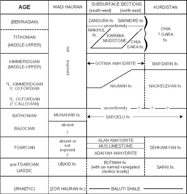
Jurassic rocks are known from many localities in the Kurdistan mountain belt, from many subsurface sections (mostly lying west of the Tigris) and from the Wadi Hauran, between H-l and H-2 pipeline stations.
Unfortunately, with rare exceptions, the rock-units which are identifiable in any one of these areas cannot be identified, by the same criteria, in either of the other areas. It is therefore necessary to recognize three more or less independent successions of rock-units of Jurassic age. Relationships of the units comprising these successions are illustrated in the following table:
Click on the image to enlarge it.
It is possible that other formations remain to be discovered, in the Wadi Hauran area, between the presumedly Lower Liassic Uba'id formation and the Bathonian Muhaiwir formation.
Only one major unconformity of any significant regional extent has been detected in the Jurassic successions. This lies between Bathonian Sargelu formation and Upper Jurassic (perhaps Callovian) Najmah formation. It is demonstrable in the subsurface sections as an erosional hiatus. At the corresponding stratigraphical position in Kurdistan, the Naokelekan appears to follow conformably upon the Sargelu, but the palaeontological sequence is either incomplete or extremely condensed in the Naokelekan, and a depositional hiatus, at least, most probably exists here.
There is no detected unconformity or sedimentary break at the Cretaceous/Jurassic boundary, but the subsurface sections show an erosional unconformity lying within the Berriasian. In Kurdistan the Tithonian-Berriasian Chia Gara formation appears to be continuous in some sections, and the formation is limited arbitrarily at the Valanginian/Berriasian stage-limit, as determined from fauna. In other Kurdistan sections there is unconformity, without angular discordance, between Valanginian Balambo formation and Tithonian Chia Gara formation.
Parts of the Jurassic succession in Kurdistan are characterized by rich ammonite faunas, but much additional collection and study of these faunas will be required before the precise age-limits of the formations can be fully known.
Only one well in southern Iraq has entered the Jurassic, and this (B.P.C. Well Ratawi No. 1) did not extend beyond the Tithonian. But one deep test in Kuwait (Burgan Well No. 113) is believed to have reached to the base of the Liassic. The Jurassic succession in this well is closely comparable with those met with in the subsurface of central Iraq (Makhul, Mileh Tharthar, etc.). Unusual features are the occurrence of thick beds of rock salt within the equivalent of the Upper Jurassic Gotnia anhydrite formation, the intercalation of a tongue of pellety neritic limestones within a unit of euxinic shales and Posidonia limestones which is equatable with the Sargelu formation of Iraq, and the appearance of vari-coloured shales and clastics within (or at the base of) the Liassic (similar vari-coloured clastics occur as an intercalation within the Lower Liassic Butmah formation in M.P.C. Well Mileh Tharthar No. 1).
Whereas the Jurassic section is thick and almost complete in the exposed anticlines of northeastern Iraq (where the single suspected discontinuity has not been demonstrated in the field), that in the western area of exposures is very incomplete. The Bathonian Muhaiwir formation is the only remnant of the Middle-Upper Jurassic transgression, and the upper and major part of the Liassic is unrepresented. In the sector lying west and northwest of Mosul the Upper Jurassic, if ever present, was removed during late Jurassic or early Cretaceous emergence: Albian Sarmord formation rests on eroded Bathonian or older Sargelu formation over a very large area.
Forty of the seventy five formations recognized in the Palaeozoic and Mesozoic succession within Iraq are entirely of Cretaceous age and four other formations range over the Cretaceous/Jurassic boundary. The complexity of the nomenclature reflects complex tectonic and depositional events, during Cretaceous times, which determined a rather rapidly changing pattern of localized sedimentational environments, each of which produced its peculiar rock assemblages.
The Palaeozoic to Jurassic succession is made up of units which preserve their identity over large regions, in which the only significant variations relate to position within a basin of large area, of which the limits other than in the southwest are unknown. The erosional unconformities which are detected appear to relate to epeirogenetic withdrawals, and there is no evidence of local structural adjustments accompanying or preceding the regressions and transgressions.
Whereas the Jurassic succession contains only a single demonstrated erosional unconformity, the Cretaceous succession is affected by no less than five major erosional unconformities, which are manifested over much or all of the region. There are also several minor erosional or non-depositional breaks, which acquire importance only locally.
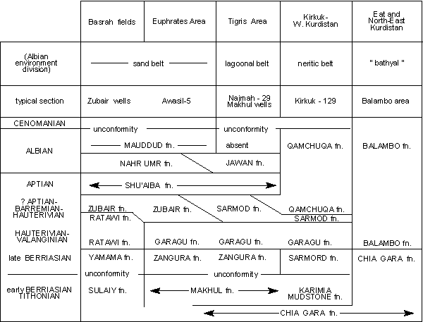
Sedimentation was continuous from Tithonian into Berriasian times in some areas, and the Makhul and Karimia mudstone formations, which are treated as Jurassic units, include Berriasian rocks in their upper parts. Both these formations are terminated by the intra-Berriasian unconformity. The Chia Gara formation of northern Iraq was also deposited continuously from Tithonian into Berriasian times, and in some areas in Kurdistan, until about the time of the Berriasian-Valanginian transition. Similarly, in the deep sections of Ratawi Well No. 1 (southern Iraq) and Burgan Well No. 113 (Kuwait) the Tithonian-Berriasian interval is represented by the succession of the Yamama formation on the Sulaiy formation. These units, introduced from the Saudi Arabian stratigraphical classification, equate approximately with the Zangura and Makhul formations of northern Iraq.
The Cretaceous rock-sequence ends, more or less abruptly in most localities (possibly throughout the region), at a major erosional unconformity of post-Maestrichtian (or very late Maestrichtian) date, which is succeeded by Palaeocene or younger sediments.
Between the limits set by the Tertiary/Cretaceous and intra-Berriasian (or "Cretaceous/Jurassic") unconformities, the succession is partitioned by a ubiquitous erosional and depositional hiatus post-dating the deposition of the Turonian, but preceding the onset of Lower Senonian sedimentation. The sequence is divided further by less important and less widespread unconformities of Albian/Aptian, Cenomanian/Albian, Turonian /Cenomanian, and early Maestrichtian or late Campanian ages.
It is convenient to consider the Lower and Middle Cretaceous units separately from those of Upper Cretaceous (post-Turonian) age.
Sedimentation in "bathyal" facies was continuous, or almost so, from Valanginian (locally from Berriasian) to late-Turonian times in the extreme eastern part of the region. The Valanginian-Turonian Balambo formation is defined to accommodate the finely bedded limestones and shales, characterized successively by ammonite, belemnite, radiolarian and globigerinal faunas, which make up the "bathyal" succession.
Passing westwards and northwestwards from the type-area of the Balambo formation (Sirwan River, Halabja, etc.), the basal sediments of the formation change laterally and very gradationally into neritic marls and marly limestones of the Sarmord formation, at the base of which the oolitic, arenaceous, biostromic Garagu formation is found in some areas.
In the Awasil and Makhul areas, the Garagu conformably overlies late-Berriasian sediments, represented by chemical limestones and calcareous shales of the Zangura formation, and in Kirkuk Well No. 109 the Garagu is conformably underlain by Sarmord formation, also of Berriasian age.
The middle portion of the Balambo formation (Hauterivian-Albian) passes laterally, westwards and northwestwards, through a variable development of Sarmord formation, into massive, neritic limestone of the Qamchuqa formation. The Balambo formation- Sarmord and Sarmord-Qamchuqa formation-boundaries are markedly diachronous (the base of the Qamchuqa, for instance, ranges in age from Hauterivian to Albian).
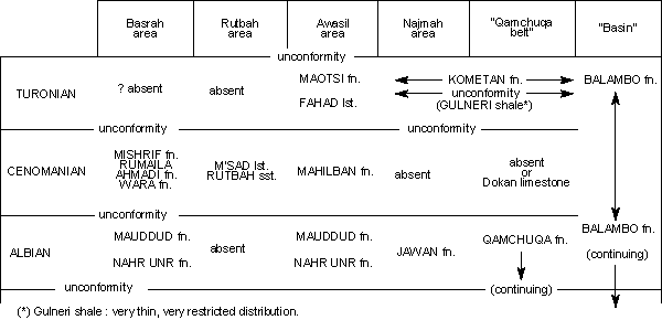
West and southwest of the broad belt in which the Qamchuqa formation is typically represented, the sediments of the Hauterivian-Albian interval are differentiated into separate rock-units. The Garagu formation, which is principally of Valanginian age, extends upwards, locally, into the Hauterivian. It is succeeded by the Sarmord formation, which is of Hauterivian-Barremian age in the area west of the Tigris, between Mosul and Makhul, but the neritic marls of the Sarmord are replaced, west of Makhul, by the sands, silts and shales of the Zubair formation. The Zubair sands provide the reservoir from which oil is produced in the Zubair and Rumaila fields of southern Iraq. They are thickly represented (but unproductive) in deep wells of Awasil, etc. The succeeding neritic limestones of the Shu'aiba formation, Aptian in age, are conformable upon the Zubair or its calcareous equivalents, and are recognizable from Qatar into northern Iraq (Najmah well No. 29). The Shu'aiba formation loses its identity, within the longer-enduring Qamchuqa formation, to the north and east of Najmah.
In the area between Najmah and Makhul, the Shu'aiba formation is overlain, probably with slight unconformity but without detectable angular discordance, by the shaly, anhydritic lagoonal Jawan formation, which is of Albian age. The Jawan passes laterally, westwards and southwestwards, into the sandstones, shales and siltstones of the Nahr Umr formation. The Nahr Umr is known in the Awasil, Nafatah, Fallujah and Mileh Tharthar wells of central Iraq, and through the oilfield region of southern Iraq into Kuwait, where it acquires great thickness and importance as the main sandstone reservoir of the oilfields of the Burgan area.
The Nahr Umr is conformably overlain by the late Albian Mauddud (limestone) formation in all areas where it has been recognized. The Mauddud is erosionally terminated at least in some parts of Iraq, the overlying units being of Cenomanian or younger age. It is discernible at Makhul, but north of the Makhul wells it is cut out at the erosional unconformity underlying the Turonian Kometan formation. To the northeast of Makhul the Mauddud is represented, but inseparable, within the neritic limestones of the Gamchqa limestone.
Relationships of the several Berriasian-Albian units of the main successions may be tabulated, thus:
Click on the image to enlarge it.
The intra-Berriasian break expands westwards from Kirkuk to Najmah (where Hauterivian Garagu formation rests on eroded Upper Jurassic) and northwestwards from Najmah through Qalian (where Albian Jawan formation lies on eroded Upper Jurassic) into the Ain Zalah-Alan area, where Aptian or younger Sarmord formation lies unconformably on eroded Bathonian to Bajocian Sargelu formation.
Thus in the region north of Najmah and west of the Tigris the lower part of the Cretaceous is not represented by sediments. The Sarmord formation is thinly represented, and the Qamchuqa formation, here of Albian age, rests conformably upon the Sarmord. The Qamchuqa passes southwards from Atshan into Jawan formation at Qalian. The Middle Cretaceous succession is terminated by an erosional unconformity of pre-Cenomanian or intra-Cenomanian age, and the sediments succeeding the Qamchuqa are of Lower Senonian or younger age in this region.
Siltstones and shales, presumedly of Albian age, intervene between the Sarmord and Qamchuqa formations in M.P.C. Well Alan No. 1. These arenaceous measures are recognized in the nomenclature as the Rim siltstone formation.
The upper part of the Balambo formation, in the northeastern zone of continuous "bathyal" sedimentation, includes thick Cenomanian and Turonian components. But as the margin of the belt of Qamchuqa limestone formation sedimentation is approached, the Cenomanian thins, and an erosional unconformity appears between Cenomanian and Albian. Very thin, patchily distributed remnants of Cenomanian Dokan limestone formation occur, locally, lying unconformably upon eroded Qamchuqa formation, in the Pir-i-Mugurun-Dokan area, and also beneath the Avanah "dome" of the Kirkuk oilfield.
Similarly, an erosional hiatus appears between the Cenomanian and Turonian globigerinal sediments as the Qamchuqa neritic limestone belt is approached, and over large parts of the zone in which the Qamchuqa is represented, its eroded top is overlain, without angular discordance, by oligosteginal-globigerinal limestones of Turonian age, which are recognized in the rock-unit classification as the Kometan formation. The Kometan is lacking from the northwestern parts of Kurdistan, where it or its equivalents were eliminated during pre-Upper Campanian emergence (or else were not deposited). However, a small remnant of contemporaneous limestones, but in rudistiferous, littoral or neritic facies, appears at Shiranish formation Islam: this isolated limestone unit is defined as the Mergi limestone formation.
The Kometan extends to the west and southwest of its type area, always in unconformable relationships with underlying units, as far as Makhul. To the southwest of Makhul its place in the sequence is taken by the neritic Fahad limestone and overlying Maotsi formations of the wells of the Awasil district. In the Kirkuk area and around Dokan, on the Lesser Zab river, a sporadic shale unit is found between the Kometan limestone and the Dokan limestone (or Qamchuqa formation where the Dokan is lacking). This shale unit, defined as the Gulneri shale, is bounded by erosional unconformities: it is of Turonian age.
Cenomanian neritic limestones are absent from most of northern Iraq. They are recognized, however, in the extreme north of the region, in the Mushorah and Gullar wells (Gir Bir formation), and in the Awasil-Nafatah-Mileh Tharthar area (Mahilban formation).
Both the Gir Bir and the Mahilban formations rest unconformably on eroded Albian units, and both are unconformably overlain by younger units. Both probably owe their survival to localized subsidences bounded by buried faults, and it may even be that the Cenomanian neritic limestones were deposited, in northern Iraq, only in contemporaneous troughs or graben which were of very limited extent.
In view of the general absence of Cenomanian shallow water sediments from most of the region, it is somewhat surprising to encounter a late-Cenomanian littoral limestone deposit as far to the west as the Rutbah area. This limestone unit, the M'sad limestone formation, is found conformably overlying and probably interdigitating with the Rutbah sandstone formation in the western rim of the Ga'ara depression. The Rutbah sandstone itself, which transgresses extensively across the eroded extremities of Bathonian to Triassic units in the Wadi Hauran to Ga'ara area, is regarded as being of Cenomanian age, but could be considerably older at its base.
In the Basrah oilfield area, as in Awasil, Fallujah, Nafatah, Mileh Tharthar, etc., the Cenomanian is represented by a limestone unit, the Mishrif formation (probably to be equated with the Mahilban limestone). Whereas the Mahilban lies unconformably on Albian Mauddud formation in the Awasil area, additional units enter between the base of the Mishrif and the top of the Mauddud in the Basrah wells. The Wara formation is a shale and siltstone unit, with a thin sporadic sandstone bed at its top in the Basrah wells. It lies with slight disconformity on the Mauddud formation, and it thickens into an important and productive reservoir unit in the Burgan field of Kuwait. It grades conformably into the shales of the overlying Ahmadi formation. The Rumaila formation, comprising globigerinal marls and limestones, is conformable upon the Ahmadi and conformably overlain by the Mishrif.
It is not yet established whether the Rumaila/Ahmadi/War a succession is represented laterally by neritic limestone equivalents within the Mahilban limestone of Awasil, or whether these formations correspond to the hiatus between the Mahilban and the Mauddud at Awasil. The second alternative is considered the more probable.
The age of the upper part of the Mishrif in the Basrah area is not firmly established. It could include Turonian components, and thus (if age attributions are correct) equivalents for all or part of the Fahad limestone and/or Maotsi formation of the Awasil area of central Iraq. Alternatively and more probably, equivalents for the Fahad and Maotsi formations may be absent from the Basrah succession in a major non-sequence separating the Mishrif formation from the overlying Khasib formation.
The preferred interpretations of relationships of the several component units of the main Turonian/Cenomanian/Albian successions are shown in tabulation below:
Click on the image to enlarge it.
Even in the northeastern part of northern Iraq, where the Lower-Middle Cretaceous succession is essentially complete, in "bathyal" facies, there is an erosional break and depositional hiatus between the Turonian top of the Balambo formation and the base of the ensuing Shiranish formation.
Over most of the country, the oldest represented Upper Cretaceous sediments are of Upper Campanian age. They transgress over an erosion surface which exposed rock-units ranging in age from Albian to Turonian.
The area north of Mosul and west of the Tigris is exceptional, for Lower Campanian and perhaps also Lower Senonian sediments occur in this area, beneath the widely transgressive, open-sea, globigerinal sediments of the Shiranish formation, and above eroded Qamchuqa formation of Albian age. The Lower Campanian-? Lower Senonian sediments comprise limestones, cherts and shales, lithology and fauna of which indicate deposition under conditions of anomalous salinity: they are defined as the Mushorah formation, and are known only from subsurface sections.
The sediments of the Upper Campanian-Maestrichtian transgression are most often the open-sea, globigerinal limestones and marls of the Shiranish formation, but these are replaced laterally by neritic or littoral limestones in some settings.
Where the transgressive Upper Senonian laps on to residual elevations of Qamchuqa formation, in the Rania-Shiranish region of northern Iraq, the Upper Campanian sediments are rudist-bearing, organic-detrital limestones, accomodated within the Bekhme limestone formation.
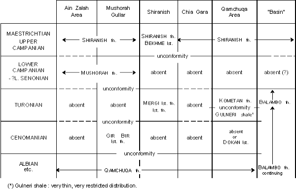
Click on the image to enlarge it.
In the area between the Tigris at Mosul and the Euphrates at Ramadi, the basal sediments of the Upper Cretaceous are neritic limestones with orbitoid and rudist debris, recognized in the nomenclature as the Pilsener limestone. They grade upwards and pass laterally eastwards into normal open-sea sediments of the Shiranish formation, which intervene, everywhere, between the areas of occurrence of the Pilsener and Bekhme limestones.
Far to the west of the Euphrates, in the area south of Rutbah, the only Upper Cretaceous unit represented at outcrop is the Tayarat limestone, a neritic-littoral formation of Maestrichtian age. The Tayarat may pass laterally and diachronously eastwards into the Pilsener limestone of the Awasil area, but this remains to be demonstrated or denied by subsurface sections.
In the Basrah area the Tayarat is represented, more or less as at outcrop, in the wells of the Zubair and Rumaila fields, etc. It forms here the uppermost unit of a sixfold succession intervening between the base of the Tertiary and the top of the Middle Cretaceous Mishrif formation. The oldest of the six units, the Khasib formation, comprises globigerinal and oligosteginal calcareous shales, marls and marly limestones, which are considered to be of basal Upper Campanian age (H.V.D.) (though ? Lower Senonian age is indicated by R.M.S. and S.N. , 1958). The contact of Khasib on Mishrif is said to be disconformable in the Basrah wells, the disconformity expanding to a major erosional unconformity over the crest of the Burgan "high" in neighbouring Kuwait ( and , op. cit.).
The Khasib is succeeded conformably by black, fissile shales of the Tanuma formation, which are conformably overlain by white, chalky, marly, globigerinal limestones of the Sa'di formation. The Sa'di also contains organic limestones with a highly characteristic fauna which is widely distributed in the lower part of the Pilsener limestone of the wells of the Tigris area, in central Iraq. Upper Campanian age for the Sa'di seems certain.
The Sa'di is overlain by glauconitic detrital limestones of the Hartha formation, characterized by a Monolepidorbis-Cosinella fauna and seemingly attributable to the Upper Campanian. However, the contact between the Hartha and Sa'di formations is an erosional unconformity, lying within or perhaps at the extreme top of the Upper Campanian succession.
The globigerinal marls and marly limestones of the Qurna formation intervene between the top of the Hartha formation and the base of the Tayarat in the Basrah area. In northern Iraq practice the Qurna, Sa'di (part), and Khasib formations could all be regarded as parts of the Shiranish formation.
Shortly after the onset of Upper Cretaceous transgression, in Upper Campanian time, important tectonic movements commenced in northern Iraq. These influenced considerably not only the thickness of the subsequent sedimentary units, but also the types of rocks which were deposited.
West of the Tigris, two rapidly subsiding troughs developed, on east-west alignments, presumably as a consequence of deep-seated faulting. In the most northerly trough, which courses below Jebel Sinjar and Sasan into the Butmah area, open-sea, globigerinal sedimentation persisted through Upper Cretaceous times, more or less in pace with subsidence. The trough-filling sediments are the normal rock-types of the Shiranish formation (though with unusual features, as intraformational conglomerates, slumped beds, etc., which reflect locally steep gradients towards the shallower margins of the trough, where fringing developments of neritic Pilsener limestone were deposited).
The southern trough, which runs beneath the Anah anticline, along the upper reaches of the Euphrates in Iraq, appears to have developed under conditions forbidding free communication with the open sea to the east. The thick sediments of the lower part of the Upper Cretaceous are marls and marly limestones, lithologically comparable with the Shiranish formation, but characterized by impoverished and restricted faunas. These sediments are included in the Jib'ab marl formation, and separated from the superficially similar Shiranish formation because of the characteristic faunal impoverishment, which reflects important genetic and geographical differences between these two formations.
The Jib'ab marl grades upwards into normal neritic Pilsener limestone at Anah, and the Pilsener is succeeded by Maestrichtian phosphatic and glauconitic marls, with abundant but highly specialized faunas, which are accorded separate recognition as the Digma formation.
Whilst the east-west troughs of the Anah and Sinjar areas were developing, another tectonic-depositional regime was initiated in eastern Kurdistan. Beyond the eastern borders of Iraq considerable uplift occurred, and older rocks, including great thicknesses of Middle-Lower Cretaceous and older radiolarian cherts and limestone, were laid open to rapid erosion. At the same time, green-rock effusive and depositional conditions were introduced. Meanwhile, in Iraq itself, a broad and rapidly deepening trough developed, on a rather sinuous but generally north-northwest to south-southeast alignment. The copious detritus derived from the uplift in the northeast was poured into the developing trough, to accumulate in great thickness. The flysch-like clastics of the trough, with their intercalations of more normal, globigerinal marls, are treated collectively as the Tanjero clastics formation.
The Tanjero usually succeeds and grades downwards into Shiranish formation, the rock-unit boundary being markedly diachronous. The successively later increments of the Tanjero were spread successively further towards the southwest.
The shifting southwestern margin of the Tanjero trough is marked locally by developments of neritic limestones of Maestrichtian age, which are accommodated within the definition of the Aqra limestone. The Aqra also occurs as far-spread tongues or lentils within the main mass of the Tanjero formation, and especially towards its top. But the fullest representation of the Aqra is in its type area, where it is founded upon massive neritic Upper Campanian limestones of the Bekhme formation. In this area the Aqra is a very thick, neritic-littoral limestone unit, from which tongues of fore-reef-shoal limestones run, northeastwards, into the marls and flysch-like clastics of the Shiranish and Tanjero formations.
The Aqra limestone/ Bekhme limestone contact is a minor erosional unconformity in some sections. The Upper Campanian Hadiena limestone formation, known only from a narrow, tectonically complicated outcrop which runs east-west from the Ora area into the Chalki-Banik area, is recognized as distinct from the contemporaneous Bekhme limestone because of the characteristic haematitic, conglomeratic and sandy nature of the Hadiena sediments. The relationships between this and other Upper Cretaceous units are somewhat obscure, save that lateral passage by interdigitation into normal globigerinal Shiranish formation is demonstrated between Chalki and Banik.
The Upper Cretaceous rock-unit succession is cut short in all studied sections in northern Iraq by the post- (or late-) Maestrichtian, pre- (or intra-) Palaeocene erosional unconformity, which expands locally to throw "lower" Miocene units into transgressive relationship with underlying eroded Maestrichtian, Upper Campanian or older formations.
Conformable relations between the Maestrichtian Tayarat formation and the overlying Palaeocene Umm er Radhuma formation are accepted in the Basrah area by most authorities (e.g. R.M.S. and S.N. , 1958). Conformity seems improbable in view of the widespread evidence of erosional unconformity between Tertiary and Cretaceous units, even in the "basinal" areas, in northern Iraq.
After this major unconformity, sedimentation started anew with the deposition of a Palaeocene - "lower" Eocene sequence. The facies distribution within this sequence was controlled by a row of islands and shoals along the eastern shore of the area of deposition. The proximity of the Arabian shield and the influence of a high in the Ga'ara area determined the facies along the western frontier of Iraq.
The row of islands and shoals separated the open sea in the west from a more or less lagoonal area in the east. The offshore sediments are grey and light brown argillaceous marls (the Aaliji formation) with a rich foraminiferal fauna of definite Palaeocene and "lower" Eocene age. The row of islands and shoals conditioned neritic sedimentation with nummulitic, alveolinid, assilinid and discocyclinid limestones (the Sinjar limestone formation). The islands are now represented by a number of small and irregularly placed breaks within this formation.
Behind this partial barrier a semi-barred lagoon developed. Erosional products from rising highs towards the east were brought down torrentially to form the marine clastic Kolosh formation, which is concentrated largely in a deep trough running from Shiranish formation in the northwest to Kashti in the southeast.
Between this clastic belt and the row of islands and shoals a more lagoonal environment prevailed, in which the Khurmala formation was deposited. Primary dolomites and chemical limestones with miliolids, valvulinids and subooliths form the bulk of this unit. The formation occurs roughly from slightly west of Mosul to slightly west of Sulaimaniya, occupying the northwestern part of the above-mentioned deep trough.
This comparatively simple picture of clastic Kolosh formation, lagoonal Khurmala formation, shoal Sinjar limestone formation and offshore Aaliji formation is complicated, however, by frequent interfingering and intergrading as well as by the existence of reef knolls of Sinjar limestone within the lagoon. The inefficiency of the islands and shoals to separate the lagoon from the open sea, and the continuous changing of position of islands, shoals and reef knolls in the shoal belt and the lagoon, resulted in a great degree of vertical and horizontal variability of the sedimentation during this period.
The lack of proper separation by the shoal belt enabled clastics to be sedimented within the offshore Aaliji formation.
The Khurmala formation interfingers and intergrades with the Kolosh formation, and the Sinjar limestone interfingers and intergrades with both the Aaliji formation (with or without Kolosh clastic elements) and the Khurmala formation (generally with clastic elements).
This pattern of sedimentation applies to eastern and northeastern Iraq. It is quite probable that, because of lack of supply of detritus and also perhaps because of scouring, the central area of Iraq, roughly between Baghdad and Hadhr, is devoid of any Palaeocene and "lower" Eocene sediments, or shows these sediments very thinly developed. Such is the case in a number of wells in this region.
The sequence then increases in thickness again towards the Euphrates and beyond, still in the offshore facies.
The proximity of the Ga'ara high, however, introduces a garland of neritic reef and shoal deposits to the east of it (the Umm er Radhuma formation).
Towards the south, Aaliji formation is still found in M.P.C. Well Fallujah No. I and B.P.C. Well Musaiyib No. 1. But lack of exposures or well sections between the last named well and the northernmost of the Basrah wells, B.P.C. Well Nahr Umr No. 1, prevents delineation of a limit or of a zone of transition between the offshore Aaliji formation of Musaiyib No. 1 and a shoal facies which is found in the Nahr Umr and Zubair areas.
This shoal facies, represented by the Umm er Radhuma formation, occurs in all B.P.C. wells and is also found at surface, further to the west. Its characters were determined by the proximity of the Arabian shield. Neither a row of islands and shoals nor a supply of clastics from this shield has been demonstrated in Iraq. Thus there is, in this southern area, no equivalent to the northern lagoonal Khurmala and clastic Kolosh formations. It is probable that the Umm er Radhuma formation changes towards the east into a more offshore deposit but there are at present no wells to test this probability.
Anhydritic measures occur above the Umm er Radhuma formation in the wells. These constitute the Rus anhydrite formation. It is likely that this formation is still of "lower" Eocene age, at least in part. The formation does not occur at surface.
Over these formations a major transgression between "lower" and "middle" Eocene brought new sediments. These again can be subdivided into a number of formations.
Sedimentation in the north and northeast was again controlled by a belt of shoals and islands, evidenced by nummulitic limestones (the Avanah limestone formation). This separated the offshore area -with open-sea sedimentation (the Jaddala formation) from a lagoonal area. Erosional products from highs in the east produced, in a deep trough, the clastic Gercüş formation, which is comparable with the older Kolosh formation. The lagoonal Khurmala formation was replaced by the similar Pila Spi limestone formation, occurring generally somewhat further east than its Palaeocene-"lower" Eocene equivalent, and occupying the northwestern part of the "middle" and "upper" Eocene trough.
Interfingering and intergrading was again prominent due to shifting positions of the shoals and islands in the partly protecting belt and in the lagoon. The supply of detritus which produced the Gercüş formation was smaller during this than during the previous period. It also seems that the belt of islands and shoals formed a more effective barrier, as Gercüş material rarely occurs within the offshore Jaddala formation.
The transgression which occurred between the two sequences is marked in the offshore area generally by a concentration of glauconite. Further inshore, sediments which were deposited in the belt of shoals and islands during the "middle" Eocene partly overlie sediments which were deposited in the lagoon during the "lower" Eocene. The lagoonal "middle" Eocene limestones overlie in part the clastic "lower" Eocene.
The controlling belt of shoals and islands moved slightly eastwards, and the trough behind it, which is filled with lagoonal and clastic sediments, moved with it. Evidence of the existence of this major transgression is provided by consequent shorewards shifting of facies belts. The Palaeocene-"lower" Eocene Khurmala formation, for instance, occurs in a broad belt between Shiranish formation and Kashti, as already mentioned. The "middle" Eocene Pila Spi limestone formation extends much further towards the northeast. Sinjar limestone, the shoal facies of the Palaeocene-"lower" Eocene, is well-developed in the area around Jebel Sinjar. In the "middle" and "upper" Eocene the more offshore Jaddala formation occupies this area.
The numerous interdigitations and intergradings within each set of formations, tend of course to obscure this picture. But on the whole each lower formation finds its facies-equivalent in the higher sequence eastwards and is itself covered by a more offshore formation.
A decrease in thickness of the Jaddala formation is apparent towards the west, into the centre of the depositional area roughly between Makhul and Baghdad. Thickness increases again from there towards the Euphrates area. The influence of the Ga'ara high is indicated first in a decrease in thickness of the Jaddala formation and further west by its replacement by a shoal facies, which can be termed either the Dammam formation or the Avanah formation. The transgression did not succeed in flooding the Ga'ara high itself.
Further towards the south the equivalent part of the Eocene is largely represented as a shoal or neritic limestone, the already mentioned Dammam formation. This formation occurs both in wells and at surface. Its relationships with the Umm er Radhuma formation and with the Rus anhydrite formation are explained fully in the "Remarks" on the formations concerned.
The age of part of the Dammam formation is uncertain. Proof exists in Arabia that the equivalent formation in that area embraces only the Middle Eocene. The Upper Eocene is absent. No such evidence exists in southern and southwestern Iraq where Upper or "upper" Eocene may thus be present, covering "middle" Eocene.
After the deposition of the Eocene a regression of some importance occurred, to be followed by a transgression of smaller extent. In a few wells on the Kirkuk structure conglomerates occur between Eocene and Oligocene, evidencing this emergence. Such conglomerates are found, however, only close to the coast. Further offshore, the seaward facies of these ages can only be separated on the basis of their microfauna.
The sedimentation during the Oligocene was governed by immigrating and emigrating organic reefs. Full details of the Oligocene stratigraphy are given in van (1956) so that a short review can suffice here.
There are three reef "cycles", each with its back-reef and reef, its fore-reef and its offshore sediments.
The first "cycle" includes the back-reef and reef facies which are represented as the Shurau limestone formation, the fore-reef which is named the Sheikh Alas limestone formation, and offshore sediments which are known as the Palani formation. The age of this "cycle" is considered to be "lower" Oligocene.
A transgression which produced a significant landwards shift of the shoreline was followed by a second "cycle", again with its back-reef and reef (the Bajawan limestone formation), its fore-reef (the Baba limestone formation) and its offshore sediments (the Tarjil formation). This "cycle" is dated as "middle" Oligocene. The various facies belts are displaced shorewards relative to the corresponding belts of the "lower" Oligocene, and the Bajawan limestonen rests partly on pre-Oligocene sediments, which formed the foreshore during the deposition of the first "cycle". Thus in Kirkuk the Bajawan limestonen rests on Avanah limestone formation of "middle" and "upper" Eocene age. Similarly the Baba limestone rests partly on "lower" Oligocene back-reef and reef deposits of the Shurau limestone. The transitional zone between Baba limestone and Tarjil formation is found further towards the shore than the transitional zone between the "lower" Oligocene fore-reef (Sheikh Alas limestone formation) and offshore sediments (Palani formation). In areas where Tarjil formation covers Palani formation directly, glauconite concentration marks the transgressional level.
A regression terminated this second "cycle" and resulted in the positioning of a third shore line seawards of the shore lines of both the first and the second "cycle".
Landwards of this third shore line Baba and Bajawan limestonen now became subject to erosion, whereas the Eocene Avanah limestone was still exposed.
Seawards of the shore line, deposits of a third "cycle" of sedimentation are found, with back-reef and reef (Anah limestone formation), fore-reef (Azkand limestone formation) and offshore sediments (Ibrahim formation). But whereas the two former "cycles" were governed by emigrating reefs, this third "cycle" shows in its thickness distribution etc. that a small transgression took place during its formation, resulting in immigration of the reef.
All three offshore facies show a decrease of thickness seawards and eventually all disappear, so that in the centre of the depositional area, Miocene Serikagni formation rests directly on Eocene Jaddala formation.
Such is the case for instance at Bara. Another example can be found in a number of wells on Najmah. In M.P.C. (ex B.O.D.) Well Qasab No. 3, Ibrahim formation rests directly on Tarjil formation which in turn covers Palani formation. In wells between Qasab No. 3 and M.P.C. (ex B.O.D.) Well Najmah No. 23 these formations vanish, and, in the last mentioned well, Euphrates limestone of "lower" Miocene age overlies Jaddala formation of "middle" Eocene age.
Occasionally there is evidence that anhydrite occurs above Eocene and below Miocene. It is likely that it replaces in such cases normal Oligocene sediments. The Iranian "Basal Anhydrite" (see , 1958, MS.) may be the equivalent of this facies of the Oligocene. It has not received a formal name in Iraq because of its sporadic occurrence.
Oligocene sedimentation is absent over the Ga'ara high. The shore of this high conditioned a belt of reef-controlled sediments around it, very similar to the reef belts in the east and northeast and comprised of the same formations as far as can be ascertained.
No Oligocene is found in any known section south of B.P.C. Well Musaiyib No. 1.
A conglomerate covers the Oligocene in the Kirkuk area as well as in sections along the Euphrates river. This conglomerate is fairly thin between Oligocene Anah or Bajawan limestonens and Euphrates limestone in the Kirkuk area. It is developed considerably more thickly in sections along the Euphrates river, where it occurs between Anah limestone and Euphrates limestone. It marks a regressional period (during which the Anah limestone was subjected to erosion as well) followed by an important transgression which introduced "lower" Miocene lagoonal sediments (the Euphrates limestone formation), along the shore of a wide sea arm or gulf. The central parts of this depositional area are occupied by contemporaneous deposits in a more or less offshore facies, the Serikagni formation. Interfingering between these two formations is frequent and transitional facies exist.
The separation between the lagoonal sediments and the offshore deposits was probably effected by a low belt of bryozoan and algal reefs. There is no well-expressed shoal facies, although certain facies in the Serikagni formation do contain fairly coarse lithophyllid detritus. The reef was low, so that breakers had little effect.
Most interfingering can be explained by frequent channels through the reef which allowed easy communication between offshore and lagoonal areas.
The Euphrates limestone was followed by an evaporitic unit, the Dhiban anhydrite. This was precipitated from sea water after the access to the gulf or sea arm, probably in the south, became wholly or partly closed.
Re-opening of this way of access brought anhydritic precipitation to an end and introduced lagoonal sedimentation once again. The Jeribe limestone formation was deposited. The original ease of access was not fully restored, as proper offshore sediments, comparable with the Serikagni formation, were not developed. It is possible that this shallowing was the result of the deposition of the Dhiban anhydrite and not of tectonic movements.
The entire "lower" Miocene (Euphrates limestone, Serikagni formation, Dhiban anhydrite and Jeribe limestone) is absent in the west, over the Ga'ara high. But Euphrates limestone and Jeribe limestone occur some 100 miles west of the Euphrates river, far beyond the westernmost limits of the Oligocene, thus stressing the importance of the basal Miocene transgression. Dhiban anhydrite is absent in this western area but the base of the Jeribe limestone is subconglomeratic in many cases.
In the Basrah area the situation is obscured by lack of knowledge about the stratigraphical position of a number of formations. There appears to be no equivalent of the "lower" Miocene.
A regression followed at the end of the "lower" Miocene. It is apparent in the Kirkuk area that, between the end of the Eocene and the end of the "lower" Miocene, Avanah limestone was exposed to erosion continuously and it is not surprising therefore that the thick conglomerate which covers the "lower" Miocene, and the entire Oligocene, and the Eocene, is composed mainly of Eocene material. Pebbles of Baba limestone formation and Bajawan limestone formation also occur, but no material of the Anah-Azkand "cycle" has been found, no doubt because these formations were protected from erosion by the overlying "lower" Miocene sediments. This conglomerate, known informally as the Basal Fars Conglomerate, marks the very important transgression which introduces the Lower Fars formation.
During the deposition of the Lower Fars formation, sedimentation was governed by events near the exit of the gulf in which it was deposited. Restriction of this exit occasioned deposition of anhydrite and salt. Opening resulted in limestone and siltstone sedimentation. The formation is considered to be of "middle" Miocene age.
After the deposition of the Lower Fars, rapidly rising mountains in the northeast of the region produced large quantities of detritus. This material was at first still deposited in a marine environment in the northern part of the depositional area. It formed the clastic Upper Fars formation of "upper" Miocene age. Meanwhile, it would seem, less clastic Middle Fars formation, consisting of limestones and siltstones, was deposited in the southern parts of the depositional region. The large quantity of mountain-derived detritus rapidly forced the sea into retreat. Continental environmental conditions spread south-wards and sands, sandstones, gravels and finally thick conglomerates (the Lower and Upper Bakhtiari formations, of Pliocene age) spread over the marine Upper and Middle Fars formations.
In the area of the Ga'ara high, the Lower Fars formation is missing. The western known limit of occurrence of this formation lies a little to the west of the Euphrates river in the Awasil area.
In the south the position is not clear. It seems that the clastic Ghar formation might be considered as a somewhat detrital facies of the basal beds of the Lower Fars formation, whereas the Zahra formation might have been deposited as lacustrine, and Chara limestones in landlocked depressions at the end of the period during which Lower Fars was being deposited. Further field work is needed to clarify the stratigraphy in this area.
Land-derived detritus subsequently formed here the thick Dibdibba formation, roughly comparable in lithology to the Bakhtiari formations of the north. Part of the Dibdibba may represent part or all of the Middle and Upper Fars formations of northern Iraq.
Middle Fars, Upper Fars, Lower Bakhtiari and Upper Bakhtiari are all absent from the area of the Ga'ara high.
Alluvium, in the form of partly lacustrine, partly estuarine, partly fluviatile deposits, overlies the Upper Bakhtiari and the Dibdibba formations. In the southern part of Iraq, however, indications of a small subrecent transgression are present between the Dibdibba formation and Alluvium. These have found recognition in recent definition of the Hammar formation.
(H.V.D.) (R.C.v.B.).
|
Palaeocene-Eocene |
Author.- R.C. van , unpublished report to Syria Petroleum Company, 1950.
Synonymy.- "Silty argillaceous globigerinal marls", van , 1956.
Type locality and section.- The type locality of this formation is in northwest Syria (Meidannki, lat. 36°29'25" N, long. 36°53' 32" E). A supplementary type locality has been chosen for Iraq.
Location.- I.P.C. Well K. 109, at lat. 35°33'08" N, long. 44°18'55" E, between drilled depths 2487 feet and 3035 feet (elevation 1193 feet; completed 6.2.53).
Brief description of supplementary section.-
Thickness: 548 feet (167 metres).
Lithology: Generally grey and light-brown argillaceous marls, marly limestones and shales with occasional microscopic fragments of chert. Rare generally scattered glauconite.
Fossils: Alabamina wilcoxensis , Ammodiscus incertus d', Anomalinoides granosa (), Cibicides beaumontianus (d'), Dorothia gibbosa (d'), Gaudryina soldadoensis and , Globigerina triloculinoides , Globorotalia angulata (), Globorotalia aragonensis , Globorotalia membranacea (), Globorotalia spinulosa , Globorotalia velascoensis (), Gyroidina naranjoensis , Karreria fallax , Parrella culter ( and ), Pullenia coryelli , Quadrimorphina allomorphinoides (), Vulvulina pectinata (), and others.
Age.- Palaeocene (2827 feet-3035 feet) and Lower Eocene (2487 feet-2827 feet).
Underlying formation and details of contact.- The Upper Cretaceous Shiranish formation underlies the Aaliji formation unconformably. This unconformity is marked by a complete change of fauna and lithology.
Overlying formation and details of contact.- The Middle Eocene Jaddala formation overlies the Aaliji formation unconformably. Here again a complete change of fauna and lithology mark the unconformity. See also R.C. van , 1956.
Other localities.- This formation occurs west and southwest of a line running roughly northwest-southeast, just north of Kirkuk, between the Tigris and the Persian frontier to the north of Chia Surkh. It is found in M.P.C. Wells Anah No. 1, Hit No 1, Abu Jir No. 1, Fallujah No. 1 and wells in the Awasil area as well as in Mileh Tharthar No. 1. The formation is absent or only very thinly represented in the wells west of the Tigris between Qalian and Makhul, and in the Azkand section on the southern dome of the Qarah Chauq Dagh.
Remarks.- The formation includes the offshore sediments of the Palaeocene and Lower Eocene interval. Although it is not in direct contact with the Kolosh formation, clastics of this formation do occur in the Aaliji occasionally. Presence of such clastics can only be explained by the ineffectiveness of the Sinjar limestone and Khurmala formation as a barrier between the landwards lagoonal area and the open sea.
Further away from the shore the supply of argillaceous matter, which largely makes up the formation, runs out, and the formation then decreases markedly in thickness. It is replaced in the area west of the Tigris and south of Mosul by a globigerinal sediment without any sedimentary matter but glauconite and numerous shells of globigerinids and other pelagics. This "facies" of the formation is also encountered in the Syrian type section, so no additional formation for this expression is necessary.
Towards the shore, interfingering takes place between the Aaliji and the Sinjar limestone over a fairly broad belt. It is especially pronounced in the wells of the Ain Zalah and Mushorah area.
(R.C.v.B.).
|
Jurassic |
Author.- H.V. , 1953; unpublished report.
Synonymy.- None.
Type locality and section.-
Location.- M.P.C. (ex B.O.D.) Well Adaiyah No. 1; lat. 30°10.5' N, long. 42°49' E; elevation 1246 feet; completed 14.3.1938. The formation is between drilled depths 3732-4029 feet, and takes its name from this well.
Brief description of type section.-
Thickness: 297 feet.
Lithology: Bedded anhydrites, with subordinate intercalations of brownish chemical limestones with anhydrite, and also of black calcareous shales and of greenish marls with anhydrite nodules.
Fossils: Nodosaria sp. (rare); Glomospira spp. (rare); lituolids indet. (very rare); rare minute ostracods; gastropod debris (small forms); echinoid elements (in 3931-3935 feet).
Age.- Not determined in type-section; presumed Liassic (probably Upper, but not uppermost) on regional correlation evidence.
Underlying formation and details of contact.- Butmah formation; contact gradational, conformable, at bottom of the lowest considerable bedded primary anhydrite above the highest oolitic or organic-detrital Butmah limestone.
Overlying formation and details of contact.- Mus limestone formation; contact gradational, conformable, at top of highest considerable bedded primary anhydrite below the lowest typical Mus limestone.
Other localities.- In M.P.C. Wells Mileh Tharthar No. 1; Makhul No. 2; Qalian No. 1; Najmah No. 29; Alan No. 1; Butmah No. 2; Ibrahim No. 1; Ain Zalah No. 16 and Fallujah No. 1.
Remarks.- The Adaiyah formation is defined as the anhydrite-dominated sedimentary unit which lies between the distinctive neritic Mus limestone, and the heterogeneous Butmah formation in subsurface sections west of the Tigris.
There are no outcrops of the Adaiyah, but the "Lithiotis limestone" of the outcropping Sehkaniyan formation at its type section equates with the Mus limestone, so that the Adaiyah may be correlated quite confidently with the lower dolomitic division of the Sehkaniyan. The Sehkaniyan is considered to be of Upper (but not uppermost) Liassic age, and the corresponding Alan anhydrite/Mus limestone/Adaiyah anhydrite sequence is similarly dated.
The base of the unit is probably slightly diachronous, due to primary lateral change of the topmost few pseudo-oolitic limestones of the Butmah into bedded anhydrites. There is also some secondary anhydritization of the topmost Butmah formation: where the secondary nature of the anhydrite is not realized, an anomalously low position is accepted for the Adaiyah/Butmah contact.
Thicknesses range from 95 feet (in Mileh Tharthar Well No. 1) to about 310 feet (in Makhul Well No. 2), this range being perhaps in part due to true diachronism and in part to false identification of the base of the unit.
The Mus formation/Adaiyah anhydrite contact is believed to be essentially
isochronous. The freshening episode, which is reflected in the change from inorganic anhydrite sedimentation to deposition of the richly fossiliferous Mus limestone, appears to have been abrupt in its commencement, widespread in its effects, and uniform in its sedimentary manifestation over a wide area. It is considered probable that the Mus is broadly correlative with the transgressive Lower Toarcian Lower Marrat formation of the Nejd exposures of Saudi Arabia, described by R.A. and M.
(1952). This assessment of age, tentative at present, has been adopted in construction of Plates
II ![]() [III
[III ![]() ]
to IV
]
to IV ![]() .
.
The Adaiyah anhydrite has not been reached in wells drilled in southern Iraq, but anhydritic measures in the Kuwait Oil Company's deep well Burgan No. 113, between drilled depths 12317 and 12410 feet, are believed to be correlative (Plate
IV ![]() ).
).
(H.V.D.).
|
Cretaceous |
The Stratigraphy of the Kuwait-Basrah Area (publication pending) (Spec. Pub., Amer. Assoc. Petrol. Geol.). "Habitat of Oil" Symposium.
Authors.- R.M.S. and S.N. , 1958.
Remarks.- The Ahmadi formation is defined from the Kuwait Oil Company's Well Burgan No. 62, but a reference section in southern Iraq is stipulated by the authors in B.P.C. Well Zubair No. 3, where the formation lies between drilled depths 8072 and 8420 feet.
In its type section and area the formation is comprised principally of shales, green, greenish grey or chocolate brown in colour in the upper parts and grey in the lower parts. A marly limestone unit at the base of the formation has been called the "Cythereis bahraini limestone": it is characterized by an abundance of ostracoda including a form identified in Oil Company practice as Cythereis bahraini (manuscript name, nomen nudum).
The Ahmadi formation in Kuwait has been termed for many years the "Cap Rock Shale", since it forms the seal retaining oil within the underlying sands of the Burgan sub-group in the Kuwait oilfields.
In the Basrah oil fields area of southern Iraq, according to and (op. cit.), "the Ahmadi formation is well developed though it does not assume the all-important economic status of a "cap-rock". In B.P.C. Well Zubair No. 3 it occurs between drilled depths 8072 and 8420 feet and consists of black silty shales at the top, with ostracods, followed by a well developed limestone member, very fine grained and unfossiliferous, grading downwards into a grey slightly detrital spicular limestone with occasional Praealveolina. Laterally this formation passes completely into either marl or limestone or any possible ratio of the two".
In both the Basrah and Kuwait areas the underlying rock-unit is the Wara formation, and in Basrah wells the overlying formation is the Rumaila. Both upper and lower contacts are gradational and conformable.
Fauna of the lower part of the formation, mostly determined from Kuwait wells (by R.G.S. , in unpublished report) includes Turritella spp., Corbula sp., Exogyra conica (J. ), Exogyra luynesi (), Neolobites sp., Parasmilia sp., and Aspidiscus (Helladastaea) juv. cf. Aspidiscus semhae . "Foraminifera and ostracoda are present throughout and become increasingly varied and abundant with increasing depth. Species of Haplophragmoides, Flabellina, Vaginulina, Ammobaculites, Gümbelina, Lenticulina, Frankeina, Haplophragmium and many others have been identified" ( and , op. cit.).
R.G.S. (unpublished report) has identified the ammonite Metoicoceras, and Exogyra luynesi () from the basal "Cythereis bahraini limestone".
The recorded ammonites suggest late Cenomanian age for the lower parts of the formation in which they are found, but the overlying Rumaila and Mishrif formations in the Basrah area are also attributed to the Cenomanian, so that Lower Cenomanian age is probable for the Ahmadi. W. (1958, MS.) argues for upper Albian age for the presumedly correlative lower parts of the Khatiyah formation of Qatar.
The limestone member occurring within the Ahmadi of Basrah wells has been termed the Tuba member, and this name is in current use, though it has not been published. This member thickens towards Nahr Umr at the expense of the argillaceous parts of the Ahmadi.
The underlying Wara formation is rather insignificant and difficult of distinction in some parts of southern Iraq. In early unpublished rock-unit classifications of the succession in the Basrah area, the combined Ahmadi and Wara formations of the current nomenclature were included within the Asara formation: this formation name, though obsolescent, still enjoys some currency in southern Iraq.
The "Cythereis bahraini limestone" subdivision of the Ahmadi has not been identified in the Basrah oilfield area, though the characteristic fauna occurs in thin limestones and in shales at the base of the formation.
(H.V.D.).
|
Palaeocene-Eocene |
Obsolete term (A'idah formation), formerly used by B.P.C. and quoted by R.C. , 1956. See Umm er Radhuma formation.
(R.C.v.B.).
|
Palaeocene-Eocene |
See Formation d'Aidah.
(R.C.v.B.).
|
Cretaceous |
Obsolete name, originally applied in unpublished Oil Company reports to the Shiranish formation encountered in the Ain Zalah oilfield of northern Iraq. The Shiranish formation is a producing reservoir formation for this and the nearby Butmah oilfield, the oil being held in fractures in the upper part of the unit (E.J. , 1954).
The Ain Zalah limestone was never defined as a formation, but the name has appeared in occasional published papers (as N.E. , 1953).
(H.V.D.).
|
Jurassic |
Author.- H.V. , 1953; unpublished report.
Synonymy.- None.
Type locality and section.-
Location.- M.P.C. (ex B.O.D.) Well Alan No. 1; lat. 36°28'N, long. 42°49' E; elevation 1229 feet; completed 2.9.1955. The formation is between drilled depth 4656 – 4841 ± 5 feet, and is named from the well.
Brief description of type section.-
Thickness: 195 ± 5 feet (drilled).
Lithology: Bedded anhydrite, with subordinate pseudo-oolitic limestone with indeterminate gastropod debris.
Fossils: None determinable.
Age.- Not known; presumed Liassic, probably Upper, on regional correlation evidence.
Underlying formation and details of contact.- Mus limestone formation; samples obscure, contact presumed gradational, at the base of the lowest bedded anhydrite.
Overlying formation and details of contact.- Sargelu formation; contact gradational, conformable, at the top of the highest bedded anhydrite.
Other localities.- M.P.C. Wells-Najmah No. 29; Qalian No. 1; Adaiyah No. 1; Butmah No. 2; Ain Zalah No. 16; Makhul No. 2; Gullar No. 1; Mileh Tharthar No. 1; K.O.C. Well Burgan No. 113.
Remarks.- This formation accommodates the bedded anhydrites and associated sediments which intervene in subsurface sections between the overlying euxinic Sargelu formation and the underlying highly characteristic Mus limestone formation. Where the Alan anhydrite is present, the Sargelu and Mus formations are sharply set apart by this intervention, but in some sections, where the Alan is not found, the boundary between Mus and Sargelu is obscure and gradational.
Lateral passage of Alan anhydrite undoubtedly occurs into both the Sargelu and the Mus formations, and is held partly responsible for the wide variation in thickness of the unit from section to section. Considerable intertonguing of anhydrite with the adjacent formations also occurs, raising difficulties in the exact recognition of formation boundaries.
It is possible that the Mus may pass laterally into anhydrite in some areas, thus producing a continuous Adaiyah-Alan anhydrite, in which differentiation of separate formations would be impossible. No such case has been encountered in any well section.
The Alan anhydrite is not found at outcrop, and yields no direct evidence of its age. It is thought, however, that the top of the Alan anhydrite (Pls.
II ![]() & III
& III ![]() ) corresponds approximately with the top of the Sehkaniyan formation, which is considered to be of Upper but not uppermost Liassic age, and that the Sargelu / Alan anhydrite / Mus limestone sequence represents the Bathonian-Bajocian-late Upper Liassic time-interval.
) corresponds approximately with the top of the Sehkaniyan formation, which is considered to be of Upper but not uppermost Liassic age, and that the Sargelu / Alan anhydrite / Mus limestone sequence represents the Bathonian-Bajocian-late Upper Liassic time-interval.
Close correlative of the Alan are found in somewhat atypical development, with anhydrites as only a minor constituent, between drilled depths 11066 and 11238 feet in the Kuwait Oil Company's deep test well Burgan No. 113 (Plate
IV ![]() ).
).
(H.V.D.).
|
Recent |
The Geographical History of the Mesopotamian Plains. Geogr. Journal, vol. CXVIII, pp. 24-39, figs. 1-8, pls. 1-4.
In G.M. and N.L. , 1952, See Hammar formation.
(R.C.v.B.).
|
Recent |
The Geographical History of the Mesopotamian Plains. Geogr. Journal, vol. CXVIII, pp. 24-39, figs. 1-8, pls. 1-4.
In G.M. and N.L. , 1952. See Hammar formation.
(R.C.v.B.).
|
Oligocene |
The Stratigraphy of the "Main limestone" of the Kirkuk, Bai Hassan and Qarah Chauq Dagh Structures in North Iraq. Journ. Inst. Petrol., vol. 42, n° 393, pp. 233-263, figs. 1-34.
Author.- R.C. van , 1956.
Synonymy.- "Formation of limestone with cerithiae", , 1838 (part); "Dolomitic limestone", de et al., 1929; "Kara Tchauq Dagh Series", , 1933 (part); "Série d'Asmari", , 1938 (part); "Calcaire d'Asmari", , 1938 (part); "Série d'Asmari", , 1938 (part); "Calcaire de l'Euphrate", , 1938 (part); "U. Oligocene limestone", , 1950b (part); "U. Oligocene-? Lower Miocene Miliola limestone", , 1950b (part).
Type locality and details of section.-
Location.- About 15 kilometres east of Nahiyah on the Euphrates river, on the southern side of the road.
Brief description of type section.
Thickness: 148 feet (45 metres).
Lithology: Limestone, grey, breccious, recrystallized, detrital and coralline.
Fossils: Algae, Anthozoa, Bryozoa, Echinoidea, Mollusca and abundant Foraminifera: Archaias sp., Austrotrillina howchini (), Borelis pygmaea , Heterostegina cf. assilinoides , Miogypsinoides complanata (), Rotalia viennoti . Numerous undetermined miliolids.
Age.- The formation is probably of "upper" Oligocene age. No strict age correlation is suggested with the Upper Oligocene of Europe.
Underlying formation and details of contact.- Azkand limestone formation, conformable.
Overlying formation and details of contact.- The Euphrates limestone formation overlies the Anah limestone formation unconformably. The contact is marked by a thick conglomerate.
Other localities.- The formation is also found at Dara Khurma, Ali Rash and the Azkand cirque on the southern dome of the Qarah Chauq Dagh. A number of wells along the southern flank of the Bai Hassan structure show it also. No Anah limestone occurs further southwards, due to facies changes. Westwards, the formation is found once more in M.P.C. Well Mileh Tharthar No. 1, in a number of sections along the Euphrates river, mostly where this river runs approximately west-east, and also in M.P.C. Well Anah No. 1. Far towards the north outliers of the formation have been found at Shiranish formation where it covers Pila Spi limestone formation of Middle and Upper Eocene age unconformably.
Remarks.- The fore-reef equivalent of the Anah is the Azkand limestone (Pl. VI ![]() ). The original material on which this rock unit is based is very badly recrystallized and dolomitized, effectively obscuring details of lithology and fauna. In such cases it is useful to describe a supplementary type section which shows better material and which moreover is better accessible. This supplementary section can be found two and a half miles from the village of Ali Rash on a bearing of 43°30', on the southern dome of the Qarah Chauq Dagh.
). The original material on which this rock unit is based is very badly recrystallized and dolomitized, effectively obscuring details of lithology and fauna. In such cases it is useful to describe a supplementary type section which shows better material and which moreover is better accessible. This supplementary section can be found two and a half miles from the village of Ali Rash on a bearing of 43°30', on the southern dome of the Qarah Chauq Dagh.
Brief description of supplementary type section.-
Thickness: 197 feet (60 metres).
Lithology: Generally white or grey dolomitized and recrystallized limestone. Massive in the lower part, becoming thinner-bedded upwards. Dolomitization is strongest in the upper part.
Fossils: In the top 128 feet (39 metres), Austrotrillina howchini (), rare Miogysinoides complanata (), rare Meandropsina anahensis , numerous undetermined miliolids.
In the middle 23 feet (7 metres), Anthozoa predominant, with rare Miogypsinoides complanata ().
In the basal 45 feet (14 metres), Anthozoa, Bryozoa and the following Foraminifera occur: Lepidocyclina s.l. spp., Miogypsinoides complanata (), Rotalia viennoti and undetermined miliolids.
Age.- An "upper "Oligocene age is accepted though no claim is made for precise correlation with the European Upper Oligocene.
Underlying formation and details of contact.- The underlying formation is not exposed here but is without doubt the Azkand limestone formation, which should underlie the Anah limestone formation conformably.
Overlying formation and details of contact, -- The Euphrates limestone formation overlies the Anah limestone formation unconformably, the contact being marked by a conglomerate.
Remarks.- Extensive and additional remarks on this formation will be found in van , 1956. One faunal zone, the Miogypsinoides zone (which see) is recognized in the formation.
(R.C.v.B.).
|
Miocene |
An informal notation (pronounced Ay nought) marking the top of a thick anhydrite occurring at the top of the Lower Fars formation in wells and in outcrops. Used for mapping purposes by geologists of the Iraq Petroleum Company. The thick anhydrite bed itself is termed, informally, the A0 anhydrite. It generally overlies limestones and marls with Ostrea latimarginata . See Lower Fars formation, Middle Fars formation.
(R.C.v.B.).
|
Cretaceous |
Author.- J. , 1945; unpublished report.
Synonymy.- None.
Type locality and section.-
Location.- Aqra, northeastern Iraq. Section runs along the Geli Sheikh Abdul Aziz, with base in the lowest exposed beds, about 1 kilometre northwest of Aqra, at lat. 36°46'43" N; long. 43°55'26" E, and with top at about 300 metres northwest of the Aqra Police Post, at lat. 36°45'58" N; long. 43°53'29" E. The uppermost beds and contact with the overlying Khurmala/Kolosh formations are better exposed about 90 metres northwest of the stream course.
Brief description of type section.
Thickness: 739.5 metres (base of formation not seen ?).
Lithology: Reef-limestone complex, with massive rudist-shoal reefs, detrital fore-reef limestone; locally dolomitized, locally siliceous, locally impregnated with bitumen.
Fossils: (Top) Plagioptychus sp., cf. Biradiolites sp.; Arcopagia cf. numismalis (d'); Bournonia aff. judaica var. laevis ; Praeradiolites saemanni ; Rhyncopygus cf. thebensis de ; R. sp.; Ampullospira incerta ; Solarium; Cardita sp.; Cyclolites sp., Elphidiella multiscissurata ; Loftusia persica ; Omphalocyclus macropora (); ? Chrysalidina sp.; Cymopolia tibetica , Cymopolia sp. nov. MS ...: (Base) Plagioptychus sp.; Bournonia cf. excavata d'; Sauvagesia sp.; cf. Radiolites sp.; ? Sphaerulites sp.; Actaeonella sp., Praeradiolites haydeni (); ? Vanikora cf. osiatica ; Natica (Lunatia) cf. judaica (); Tylostoma cf. rochaiti (d'); Omphalocyclus macropora (); Monolepidorbis sp.; Orbitoides media (d'); Dicyclina schlumbergeri ; Cuneolina cylindrica ; Dictyoconella complanata ; Elphidiella sp.; Loftusia cf. coxi ; L. spp.; ? Chrysalidina sp.; Globotruncana stuarti (de ); Cymopolia tibetica ; Cymopolia sp. nov. MS.
Age.- Probably Maestrichtian throughout.
Underlying formation and details of contact.- Probably not seen in type section (see Remarks).
Overlying formation and details of contact.- Kolosh clastic formation; very thin, passing upwards into Khurmala formation (see Remarks). The contact is unconformable, the Kolosh being conglomeratic at its base, and transgressive over eroded Aqra limestone.
Other localities.- Zinta Gorge, Bekhme, Diza, Gund-I-Shikavt, Zibar, Chalki, Ser Amadia, Hadiena, Rowanduz, etc....
Remarks.- The Aqra limestone in its type area is a massive, cliff-forming limestone unit, much dolomitized, and generally characterized by rudist, Omphalocyclus-Loftusia-Orbitoides, and gastropod faunas. The Aqra limestone is usually of Maestrichtian age.
At its type locality, the possibility exists that the lower part of the thick reef-limestone sequence may be of Upper Campanian age, and continuous with the Bekhme limestone formation. At Dar-e-Tesu, and other locations, the Aqra limestone is developed as isolated tongues and lentils of neritic rudist-bearing limestones, at the top of or within the Tanjero clastic formation, a variable thickness of Tanjero clastic formation and/ or Shiranish formation intervening between the base of the Aqra limestone and the top of the Bekhme limestone.
Where the Aqra limestone is superimposed directly upon the Bekhme limestone, without intervention of Shiranish or Tanjero formations, the composite name Aqra/Bekhme limestone may be used. The justifications for recognition of the Aqra and Bekhme formations as separate units lie in the general occurrence of marl and clastic tongues between the two limestones in the area of outcrop, and in suggestions of a minor erosional break terminating the Bekhme limestones in some sections.
The faunas of the upper and lower parts of the type section indicate near-continuity in facies and in fossil assemblages, and no proven break occurs within the sequence, so that it is probable that the base of the Aqra limestone is not exposed.
The Aqra exists as the uppermost of three superimposed units of thick-bedded Lower to Upper Cretaceous limestones on Aqra Dagh, and in the Jebel Gara and Ser Amadia areas, etc. The Shiranish formation which comprises globigerinal marls and marly limestones of Upper Campanian-Maestrichtian age, takes the place of the Aqra in the areas lying to the south and west of the type section. It is presumed that the passage from Aqra to Shiranish formations is by interdigitation, since the Aqra-Shiranish transition in isolated sections is often gradational and alternating. Similar passage from massive neritic Aqra to globigerinal Shiranish formation occurs between Ser Amadia and the Shiranish formation type section, where Maestrichtian globigerinal limestones (Shiranish formation) overlie neritic Bekhme limestone of Upper Campanian age.
In the area between Aqra and Dar-e-Tesu, at the northern end of the Bekhme gorge, the Aqra passes laterally eastwards into Shiranish formation (at the base) and also by interdigitation into the Maestrichtian Tanjero formation, which overlies the Shiranish formation.
Occasional tongues or lentils of reef-type limestones occur, within the Tanjero, at Dar-e-Tesu, and elsewhere in the area lying to the northeast of the main development of the Aqra. Similar lenses, often attaining considerable thickness, appear intermittently within the thick Tanjero clastics in areas far removed from Aqra.
Since all such lentils and tongues of reef-type limestones present similar lithological and faunal characteristics, it is considered unnecessary to distinguish amongst them by separate names: all are referred to the Aqra limestone formation. They frequently contain shoals of rudists, especially Trechmanella persica , etc., or of Cyclolites spp., and they usually carry rich foraminiferal faunas with Loftusia persica , L. morgani , L. spp., Omphalocyclus macropora (), Siderolites calcitrapoides , etc....
The relationships of the Aqra formation to the partly-contemporaneous Hadiena (conglomeratic limestone) formation of the Ora-Chalki area remain somewhat obscure, but lateral passage between these two units must occur in the unexposed area between Ser Amadia and the Hadiena outcrops. Typical Aqra limestone limestone overlies the Hadiena in its type section, grading down into Hadiena by alternation.
In the Aqra section, there are several evidences of unconformity at the top of the Aqra limestone.
The Loftusia-bearing uppermost beds of the Aqra are extremely dolomitized limestones, without any trace of far-travelled clastics. The top of these beds is slightly irregular, suggesting but not proving erosion. The immediately overlying beds are marly, calcareous siltstones with abundant chert and green-rock detritals, typical of the clastics which contribute to the Tanjero and Kolosh clastic formations: these beds are also markedly conglomeratic, containing minute to bean-sized recrystallized limestone pebbles in some thin beds, whilst intervening beds are pseudoconglomeratic, as a result of penecontemporaneous disturbance of alternating silty and silt-free limestones.
The silty beds contain abundant fragments of derived Omphalocyclus and other Maestrichtian forms, some of which are bitumen-impregnated, in addition to rare Tertiary index fossils, including Globorotalia sp., typical miliolids (which do not occur in the Aqra), and occasional Tertiary algae. The silty conglomeratic Kolosh clastic formation is only a few feet thick, and grades upwards into the primarily dolomitic limestone of the overlying Khurmala formation, which is of Palaeocene age, and which contains derived Maestrichtian fossils at Aqra, and also at Dar-e-Tesu, Bekhme and elsewhere.
The uppermost beds of the Aqra limestone are fore-reef-detrital limestones, whereas the Khurmala formation is a lagoonal formation. Hence a considerable regression, at least, must be argued between the times of deposition of the Aqra and Khurmala units. But it is clear that there was here no gentle regression, since there is an abrupt transition from Loftusia limestones to Kolosh clastic formation (without any intervening reef-limestone deposition), and since derived Maestrichtian fossils enter in the same beds as the coarse clastics of distant (north-eastern) derivation.
The Aqra type-section is noteworthy for spectacular bitumen impregnation, to be seen in the upper beds of the Aqra limestone (, 1950b). Derived Maestrichtian fossils in the basal Kolosh formation are bitumen-filled, whilst indigenous Palaeocene fossils are usually free from bitumen. Hence it may be inferred that the Aqra limestone of Aqra already contained a heavy-oil accumulation at the time of post-Maestrichtian emergence.
Stranded pebbles of bitumen, which appear sporadically in the basal Palaeocene conglomerates in some localities in northern Iraq and in southwestern Persia (P.F. , F.C. and A.N. , 1951), may have originated from seepages from this or similar pre-Palaeocene oil accumulations, after breaching of cap-rock seals during post-Maestrichtian erosion.
The Pilsener limestone of subsurface sections west of the Tigris is in some ways comparable with the Aqra, being neritic, rudist-bearing, and massive. The upper part of the Pilsener was deposited contemporaneously with the lower part of the Aqra. The two formations are afforded separate recognition because they occur in different areas, and are genetically distinguishable.
The Aqra, as a massive, tabular, limestone unit, is restricted to the Rowanduz-Aqra-Ser Amadia area, and, as a tonguing complex of lenticular limestones, is found only in the deep clastics-filled trough of the northeast.
The Pilsener appears, as a tabular limestone formation, fringing the western margins of the Upper Campanian-Maestrichtian basin, and as tongues, extending from the basin-margins and from near-marginal highs, into globigerinal marly sediments of clastic-free troughs within the main basin.
The palaeogeographical limitations controlling these formations are reflected in the microfauna, the Pilsener being generally characterized by restricted Monolepidorbis-Pseudedomia faunas only, whilst the Aqra has much more varied and numerous faunas.
The Tayarat formation, described from the Western Desert area, is more closely comparable with the Aqra, in age, fauna and facies, than is the Pilsener, but the Aqra and Tayarat formations are given separate recognition because they are palaeogeographically and genetically distinct.
The Aqra is limited to the tectonically-active, northeastern margin, and the Tayarat to the more quiescent, gently-shelving, southwestern margin of the broad Upper Senonian basin. There are no comparable, linking, neritic rock-units connecting the two formations across the central zone of the basin.
In the subsurface sections of the Basrah area the equivalents of the Aqra limestone, in comparable facies, are the Tayarat and Hartha formations. The Qurna formation, which separates the Tayarat from the Hartha, is a marly globigerinal unit which would be interpreted in northern Iraq as a Shiranish formation tongue. The unconformity between the Hartha and the underlying Sa'di formation in the Basrah-Kuwait area is equated, tentatively, with that which separates the Aqra and Bekhme limestones in some sections in northern Iraq. This unconformity is accepted, for the purposes of plate construction, as embracing the Maestrichtian/Campanian stage boundary, but at its narrowest expression it could lie within the Lower Maestrichtian or, more probably, within the Upper Campanian.
(R.W. and H.V.D.).
|
Cretaceous |
Mesozoic Rocks of Eastern Saudi Arabia (abstract). Bull. Amer. Assoc. Petrol. Geol., vol. 36, n° 5, p. 909.
In eastern Saudi Arabia the outcropping Upper Cretaceous (? Upper Campanian-Maestrichtian) rock succession, comprising limestones, dolomites, and calcareous and dolomitic shales, has been termed the Aruma formation (M. and R.A. , 1952). In southern Iraq and Kuwait the Aruma has been ranked as a group (R.M.S. and S.N. , 1958) which, in the Basrah area of southern Iraq comprises, in descending stratigraphical order, the Tayarat, Qurna, Hartha, Sa'di, Tanuma and Khasib formations.
According to and (op. cit.). the lowest formation of the group rests disconformably on the Mishrif formation in southern Iraq, but the contact between the Tayarat and the overlying Umm er Radhuma formation is conformable.
In view of the widespread evidence of discontinuity between the Maestrichtian and Tertiary units elsewhere in Iraq, conformity between the Tayarat and Umm er Radhuma in the Basrah area may be doubted, despite the lack of evidence of any stratal convergence at this boundary.
The Aruma group as employed by and embraces an important erosional unconformity, between the Hartha and Sa'di formations, which probably occurs throughout the Basrah oilfields (E. , 1957; unpublished reports). The same unconformity has been recognized for some years in southern Kuwait between the Hartha and the Gudair formation, which replaces the Sa'di formation in this area (R.M.S. and S.N. , 1958).
In northern and central Iraq the Aruma group is not recognized in the classification of units, and the lithologies of some correlative sediments differ considerably from those of the constituent formations of the group as found in the Basrah area. But the corresponding rock unit succession in northern Iraq is clearly set apart from the Tertiary and Middle Cretaceous formations by erosional unconformities.
(H.V.D.).
|
Cretaceous |
Author.- P.M.V. , 1952; unpublished report.
Remarks.- The Asara formation is an obsolescent name, originally applied in the subsurface classification in the Basrah area of southern Iraq to the succession which is now subdivided into the Ahmadi and Wara formations (R.M.S. and S.N. , 1958). Although the Asara formation is not included in the classification of and , it is still recognized by some workers in southern Iraq, and it has some utility in areas where distinction between the Ahmadi and Wara is difficult.
(H.V.D.).
|
Miocene |
Sur la Géologie de l'Irak. C.R. Acad. Sci., vol. 189, p. 1000.
In H. de et al., 1929. See Euphrates limestone formation, Jeribe limestone formation.
In C.P. , 1933. See Euphrates limestone formation, Jeribe limestone formation.
See also Asmari limestone.
(R.C.v.B.).
|
Miocene |
See Bancs de l'Asmari.
(R.C.v.B.).
|
Oligocene-Miocene |
See Calcaire d'Asmari.
(R.C.v.B.).
|
Miocene |
See Calcaire de l'Asmari.
(R.C.v.B.).
|
Eocene-Oligocene-Miocene |
Some notes on the Geology of the Persian Oilfields. Journ. Inst. Petr. Techn., London, vol. 5, n° 17, pp. 3-26.
Originally this term was introduced in Iran by H.G. and H.T. (1918). See also (1958, MS.). The name "Asmari" has been used in Iraq by several authors, with various qualifications (q.v.), for limestone sections wholly or partly equivalent to the type section at Asmari Mountain in S.W. Iran. In Iraq the term is obsolete. See Avanah limestone formation, Pila Spi limestone formation, formations of the Kirkuk group, Euphrates limestone formation, Jeribe limestone formation.
(R.C.v.B.).
|
Eocene |
(R.C.v.B.).
|
Palaeocene |
Aspects géologiques du désert occidental de l'Irak. Bull. Soc. Géol. France, 6° serie, t. VI, fasc. 4-5, pp. 391-406, figs. 1-3, table.
Author.- R.C. , 1956.
Description (from R.C. , op. cit.).- "Dans l'Oued Auja, à l'intérieur de la dépression de Ga'ara, des sables marneux et des grès, des calcaires dolomitiques, des lentilles et des chapelets de cherts et quelques flints viennent en concordance sur le calcaire de M'sad. La formation est en général très fossilifère, la plupart des fossiles étant silicifiés ou formés de dolomies."
Remarks.- attributes this formation to the Cretaceous, but the authors' interpretation of the stratigraphy in this area is that the M'sad formation is unconformably overlain by the Palaeocene Umm er Radhuma formation, which corresponds in lithology to the quoted description. The Auja formation is therefore excluded from consideration as a Cretaceous unit and treated as a synonym of the Umm er Radhuma (R.M.S. and S.N. , 1958).
(H.V.D.).
|
Eocene |
Author.- J. , in unpublished work, 1953.
Synonymy.- "Qarah Chauq group", , 1948 (part); "FEM", , 1954; "FEU", , 1954; "Middle Eocene shoal facies", van , 1956; "Upper Eocene shoal facies", van , 1956.
Type locality and details of section.-
Location.- I.P.C.-well K-116, lat. 35°47'28".99 N, long. 43°59'06".34 E, on the Avanah dome of the Kirkuk structure; elevation 1290.83 feet; completed 17.1.48. The formation lies between drilled depths 2205 and 2899 feet.
Brief description of type section.
Thickness: 694 feet (212 metres).
Lithology: Limestones, generally dolomitized and recrystallized, of shoal facies, with occasional intercalations of lagoonal dolomitized limestones (Pila Spi limestone). The top part is less recrystallized and dolomitized than the part below 2394 feet drilled depth.
Fossils: Alveolina elliptica () var. flosculina , Asterigerina rotula (), Asterocyclina sp., Baculogypsinoides sp. (only above 2394 feet drilled depth), Dictyoconus aegyptiensis (), Discocyclina spp., Nummulites atacicus , Nummulites bayhariensis (only below 2394 feet drilled depth), Nummulites discorbinus (), Nummulites fabiani (), Nummulites gizehensis (), Operculina sp., Orbitolites complanatus , Pellatispira madaraszi (), Sphaerogypsina sp.
Age.- The age of this formation is undoubtedly "upper" and "middle" Eocene. In rare cases it is possible that part of the "lower" Eocene is represented as well. It is almost certainly in all other cases directly correlatable with the European Upper and Middle Eocene. The limit between Upper and Middle Eocene at the type locality occurs between 2394 feet drilled depth and 2439 feet drilled depth. The interval the age of which is in doubt is too strongly recrystallized.
Underlying formation and details of contact.- The Khurmala formation underlies this formation, probably unconformably. For details on this contact see the "Remarks" on the Khurmala formation.
Overlying formation and details of contact.- The Lower Fars formation covers the Avanah limestone formation unconformably. The contact is marked by a conglomerate, the Basal Fars conglomerate. The Lower Fars transgression has truncated the Upper Eocene and Middle Eocene to some extent.
Other localities.- A belt of Avanah limestone formation known for the most part only from wells, trends roughly N-135°-E from M.P.C. Well Mushorah No. 1 in the northwest to the Baski Zanur Dagh in the southeast, where the unit occurs at outcrop. This belt has a width of the order of twenty to twenty five miles (thirty two to forty kilometres).
On the western side of the Eocene basin Avanah limestone formation is found in water wells near the I.P.C. Pipeline station of H/l and in Wadi Shagoul.
Remarks.- This formation is the shorewards equivalent of the Jaddala formation with which it interfingers. Its interdigitation with the formation representing a still more coastward formation, the Pila Spi formation, can be observed in a number of wells on the Kirkuk structure. The fauna varies but remains typical of the shoal realm, with numerous nummulites and discocyclinids. Mixed faunas occur in the area of interdigitation, e.g. numerous alveolinids are found.
At Shiranish formation the limit between Avanah sedimentation and Pila Spi sedimentation has probably been reached as it is here that the easternmost mixed faunas occur.
The upper contact varies a great deal, dependent on the geographical position of the point of observation. Within the Kirkuk structure Bajawan limestone formation can rest unconformably on the Avanah limestone formation, the contact again being marked by a conglomerate. This conglomerate is not the same as the Basal Fars conglomerate mentioned above. Details can be found in R.C. van , 1956.
(R.C.v.B.).
|
Cretaceous |
Obsolete name, originally applied by H. (1940, unpublished report) to the Zubair formation as encountered in B.O.D. Well Awasil No. 5. The name was never published.
(H.V.D.).
|
Oligocene |
The Stratigraphy of the "Main limestone" of the Kirkuk, Bai Hassan and Qarah Chauq Dagh Structures in North Iraq. Journ. Inst. Petrol., vol. 42, n° 393, pp. 233-263, figs. 1-34.
Author.- R.C. van , 1956.
Synonymy.- "Dolomitic limestone", de et al., 1929 (part); "Kara Tchauq Dagh Series", , 1933 (part); "Calcaire d'Asmari", , 1938 (part); "Série d'Asmari", , 1938 (part); ? "Calcaire de l'Euphrate", , 1938 (part).
Type locality and details of section.-
Location.- Northeast face of the Azkand cirque, three miles N-65°-E of the village of Azkand on the southern dome of the Qarah Chauq Dagh.
Brief description of type section.
Thickness: 340 feet (104 metres).
Lithology: Generally massive, dolomitic and recrystallized limestones, generally with high porosity.
Fossils: Heterostegina cf. assilinoides , Miogypsinoides complanata (), Rotalia viennoti . Added to this assemblage are Lepidocyclina s.l. spp. in the lower 250 feet (76 metres).
Age.- The formation is probably of "upper" Oligocene age, but this does not imply strict correlation with the Upper Oligocene of Europe.
Underlying formation and details of contact.- Baba limestone underlies the formation unconformably. The two formations are separated by a regression which has been discussed in van (1956).
Overlying formation and details of contact.- The Anah limestone formation, which is the reef and lagoonal equivalent of this unit, overlies the Azkand conformably.
Other localities.- In the western part of Iraq, the Anah limestone formation overlies the Azkand conformably. Azkand limestone formation is developed in sections along the Euphrates. It also occurs in M.P.C.-Well Mileh Tharthar No. 1.
In the eastern part of Iraq, a few isolated occurrences (isolated because wells were not drilled in areas where this formation should occur extensively below surface) are found in the Qaiyarah structure in M.P.C. (ex-B.O.D.) Wells Qaiyarah Nos. 13 and 21 and in M.P.C. Wells Gusair No. 1 and Ibrahim No. 1.
Remarks.- For extensive remarks on the stratigraphic position of this formation and its relation to other formations, see van , 1956. It suffices here to say that the Azkand limestone formation is considered to be the fore-reef equivalent of the reef and lagoonal Anah limestone formation and that it interfingers towards the southwest with the Ibrahim formation as in M.P.C. Well Ibrahim No. 1.
The Azkand limestone formation has been subdivided tentatively into an older Lepidocyclina-Miogypsinoides zone and a younger Miopypsinoides zone, which see.
(R.C.v.B.).
|
Miocene |
Informal notations for markers in the Seepage Beds. See Lower Fars formation.
(R.C.v.B.).
|
Oligocene |
The Stratigraphy of the "Main limestone" of the Kirkuk, Bai Hassan and Qarah Chauq Dagh Structures in North Iraq. Journ. Inst. Petrol., vol. 42, n° 393, pp. 233-263, figs. 1-34.
Author.- R.C. van , 1956.
Synonymy.- "Rubbly limestone", de et al., 1929; "Limestones containing Lepidocyclina cf. formosa", de et al., 1929; "Kara Tchauq Dagh Series", , 1933 (part); "Calcaire d'Asmari", , 1938 (part); "Série d'Asmari", , 1938 (part); ? "Calcaire de l'Euphrate", , 1938 (part); "Nummulite limestone", , 1948; "Qarah Chauq group", , 1948 (part); "FO/2", , 1954.
Type locality and details of section.-
Location.- I.P.C. Well K-109 on the Baba dome of the Kirkuk structure; elevation 1193 feet; completed 6.2.53; lat. 35°33'08" N, long. 44°18'55" E. The formation lies between the drilled depths of 1545 feet and 1615 feet.
Brief description of type section.
Thickness: 65 feet (20 metres).
Lithology: Porous dolomitized limestone.
Fossils: Rare Bryozoa, rare Lepidocyclina s.l. spp., Nummulites intermedius-fichteli d' and , Operculina sp. Occasionally Rotalia viennoti and Heterostegina cf. assilinoides also occur.
Age.- A "middle" Oligocene age has been adopted for this formation, without claiming, however, that it is strictly correlatable with the European Middle Oligocene.
Underlying formation and details of contact.- The Shurau limestone formation underlies this formation unconformably. The nature of the contact is extensively commented upon in van (1956).
Overlying formation and details of contact.- The formation is covered conformably by the extension of its lagoonal equivalent, the Bajawan limestone formation. Some claim a local unconformity between the two formations, but the evidence brought for this is not considered convincing.
Other localities.- In eastern Iraq the formation occurs widespread in all wells southeast of the Lesser Zab, on the Kirkuk structure. It also occurs on the northeast flank of the Bai Hassan structure, and at surface on the northern dome of the Qarah Chauq Dagh. Northwards, the Baba limestone formation is found in a number of M.P.C. wells, including Qalian No. 1, Gullar No. 1, Gusair No. 1 and wells on the Ain Zalah structure. To the west of its type locality the formation changes its facies into the Tarjil formation which disappears further west. The Baba limestone re-appears on the western side of the Oligocene basin in M.P.C. Wells Hit No. 1, Fallujah No. 1, and Anah No. 1. A number of surface sections along the Euphrates river, where its course is predominantly west-east, also show this formation (e.g. Wadi Fuhaimi, near the village of Anah, and Wadi Kheskeh es Sharqi).
Remarks.- Extensive remarks on this formation can be found in van 1956. The formation forms the fore-reef equivalent of the lagoonal Bajawan limestone formation and changes its facies seawards into Tarjil formation. Interfingering of the Tarjil formation with the Baba limestone formation takes place extensively in the Bai Hassan structure and in the southern part of the Kirkuk structure. No such interfingering of the Baba has been noted with the Bajawan limestone formation. The Baba limestone generally covers Shurau or Sheikh Alas limestone formation but, as it is part of a transgressive sequence of sediments, it can occur immediately on eroded Eocene units.
The formation is subdivided into two faunizones, separated on the basis of their faunal content. The oldest one is the Nummulites-Lepidocyclina zone, the younger one the Lepidocyclina zone. More details may be found under those headings.
(R.C.v.B.).
|
Cretaceous |
See Qurna formation. Remarks.
|
Palaeocene-Eocene |
In G.E. , 1908.
See Hasa group.
(R.C.v.B.).
|
Oligocene |
The Stratigraphy of the "Main limestone" of the Kirkuk, Bai Hassan and Qarah Chauq Dagh Structures in North Iraq. Jour. Inst. Petrol., vol. 42, n° 393, pp. 233-263, figs. 1-34.
Author.- R.C. van , 1956.
Synonymy.- "Kara Tchauq Dagh Series", , 1933 (part); "Calcaire d'Asmari", , 1938 (part); "Série d'Asmari", , 1938 (part); ? "Calcaire de l'Euphrate". , 1938 (part); "Qaraq Chauq Group", , 1948 (part); "Miliola and reef limestones", , 1948 (part); "Oligocene limestone", , 1950b (part); "U. Oligocene Miliola limestone", , 1950b (part); "Oligocene Miliola limestone", , 1950b (part); "Miliola limestone", , 1950b (part); "MR/2", , 1954.
Type locality and details of section.-
Location.- I.P.C. Well K-109 at lat. 35°33'08" N and long. 44°18'55" E; elevation 1193 feet; completed 6.2.53. The formation lies between drilled depths of 1410 feet and 1545 feet.
Brief description of type section.
Thickness: 128 feet (39 metres).
Lithology: Tight, cream-coloured, back-reef miliolid limestones, alternating with more porous, partly dolomitized, rotalid-algal reef limestones -with fairly abundant coral fragments. The reef beds become thicker and more abundant towards the base of the formation. Thin wisps of unfossiliferous green marl occur throughout.
Fossils: Actinacis sp., Anthozoa spp. indet., Bryozoa spp. indet., Corallinacaea spp. indet. and the following Foraminifera: Archaias kirkukensis , Austrotrillina howchini (), Peneroplis evolutus , Peneroplis thomasi , Praerhapidionina delicata . Occasionally Borelis pymaea , Meandropsina anahensis and Rotalia viennoti also occur.
Age.- The age of this formation is most probably "middle" Oligocene. Evidence for precise correlation directly with the Middle Oligocene of Europe is lacking.
Underlying formation and details of contact.- The Baba limestone formation; contact conformable, although some claim a local unconformity between the two formations. The evidence for this is not considered convincing.
Overlying formation and details of contact.- The Lower Fars formation overlies the Bajawan limestone formation unconformably and is separated from it by the Basal Fars conglomerate.
Other localities.- The formation occurs at outcrop on the northern dome of the Qarah Chauq Dagh. Southwards and westwards from this locality the formation disappears because of facies-changes via fore-reef sediments (Baba limestone formation) into offshore sediments (Tarjil formation). The coast line follows roughly a west-northwest to east-southeast course, however, and the Bajawan limestone formation is therefore met with in all wells drilled on the northern flank of the Bai Hassan structure and in all wells drilled on the Kirkuk structure south of the Lesser Zab river. It is then lost because no wells were drilled in the area to the southeast of Kirkuk but it occurs finally at surface in Baski Zanur Dagh, Aj Dagh and Derbannd-i-Sagirrma. There the formation was deposited very close to the shore line and consequently is very thin and conglomeratic.
North of the Qarah Chauq Dagh the formation can be found in a number of M.P.C. wells, including Qalian No. 1, Gullar No. 1 and Ain Zalah No. 9.
Westwards the Bajawan also occurs on the southwestern side of the Oligocene basin, in M.P.C. Wells Hit No. 1, Fallujah No. 1 and Anah No. 1.
Absence of the formation in the area between Qarah Chauq Dagh and the last mentioned wells is due to facies changes.
Remarks.- Extensive remarks on this formation can be found in van 1956. The formation is considered to be the back-reef equivalent of the Baba limestone formation. Towards the shore it overlaps older Oligocene and even Eocene sediments.
The formation is subdivided into two faunizones distinguished on the basis of their faunal content. The oldest one is the delicata zone, the younger one the kirkukensis zone. More details are found under those headings.
(R.C.v.B.).
|
Pliocene |
Term introduced by A.H. (1926); synonymous with Bakhtiari group, which see.
(R.C.v.B.).
|
Pliocene |
Group of fluviatile and estuarine sediments, resulting from erosion off rising mountains into sinking basins. It comprises the Upper and Lower Bakhtiari formations.
(R.C.v.B.).
|
Pliocene |
The Geology of the Persian Gulf and the Adjoining Portions of Persia and Arabia. Mem. Geol. Survey, India, vol. XXXIV, pl. 4, pp. 1-177.
Under the nomenclatural rules followed ( et al., 1939), the term should be replaced by Bakhtiari group. As a series this term was introduced first by G.E. (1908) for Iran.
See Bakhtiari group, and (MS., 1958).
(R.C.v.B.).
|
Cretaceous |
Author.- R. , 1947; unpublished report.
Synonymy.- None.
Type locality and section.-
Location.- Sirwan Valley, near Halabja, North Iraq. Southern scarp-face of Jebel Balambo, about 3 kilometres due east of the village of Kawata, which lies on the north bank of the Sirwan at the confluence of the Sirwan and Zimkan rivers. The section runs south to north up the scarp, approximately on long. 45°57'12" E, with base in the Sirwan at about lat. 35°5'7.8" N, and with top at about 2900 feet.
The lower part of the section was sampled in subsidiary type-sections to the east: i) basal 65 metres on line running north from the path from Hawar to Dalamar, with base at 1.3 kilometres N 70° E from Dalamar, at about lat. 35°9'30" N, long. 46°3'12" E, ii) succeeding 61.4 metres in scarp, 1 kilometre southwest of Kosawa and 2 kilometres southeast of Sazan police post, at about lat. 35°5'6" N, long. 46°4'8" E.
Brief description of type section.-
Thickness: 762 metres.
Lithology: Upper division of 503 metres; thin-bedded globigerinal, passing downwards to radiolarian limestones, grey, weathering white, forming smooth weathered slopes without marked features. Lower division of 259 metres; thin-bedded, blue ammonitiferous limestones with intercalations of olive green marls and dark blue shales.
Fossils: Turonian: 315 metres; rich planktonic foraminiferal fauna with: (at top) Globigerina cretacea d', Globigerina aspera (), Globigerina spp., Rugoglobigerina spp., Globotruncana cf. cretacea , G. lapparenti bulloides , G. lapparenti tricarinata (), G. lapparenti , G. lapparenti coronata (near middle), Gümbelina spp., Gyroidina sp., Pseudotextularia cf. elegans (); also Inoceramus debris, ostracods, Oligostegina: (at base) Globotruncana lapparenti subspp.(as above, declining downwards), G. sigali , G. renzi , G. alpina , G. helvetica , Rotalipora appenninica (), Gümbelina spp., Shackoina cenomana (), Oligostegina, etc., rare Bulimina sp., rotalids, etc. Cenomanian: 168 metres; Rotalipora appenninica () typica (), R. appenninica (), R. alpha (), Globigerina spp., Globigerinella sp., Hastigerinella simplex , H. sp., Globotruncana cf. alpina , Thalmanninella ticinensis (), Mantelliceras sp.; Radiolaria, etc., and Oligostegina. Albian: 90 metres; (near top), Oxytropidoceras sp., Prohystoceras sp. and (near base) Hilobites sp., Idiohamites sp., Hibolites subfusiformis auctt., Pachydesmoceras denisonianus auctt. non : also, at base, Ticinella roberti (), Planulina pustulosa , Valvulineria spp., Radiolaria. Aptian-Barremian: 62 metres; belemnites indet., Radiolaria; Pseudohoploceras sp., at base. Hauterivian-Valanginian: 126 metres; upper unit ("Duvalia zone" of 66 metres); Hibolites sp., Phylloceras tethys (d'). Radiolaria; middle unit ("Hoplites zone" of 41 metres); ? Crioceras plicatilis (), Crioceras sp., ? Neocomites houdardi , Olcostephanus sp., Distoloceras sp., Acanthodiscus sp., Thurmannites sp., Holcodiscus sp., Hoplites karakashi , etc.; lower unit ("Crioceras zone" of 19 metres); Crioceras plicatilis (), Crioceras raricostatum (), Neocomites houdardi , Olcostephanus sp.
Age.- Turonian, at top, to Valanginian, probably Upper Valanginian, at bottom.
Underlying formation and details of contact.- Chia Gara formation; contact non-sequential, without sign of angular discordance or erosion, but with absence of basal Valanginian and probably most or all of the Berriasian. Contact taken at base of a thick succession of fine-grained, thin-bedded limestones, of dark blue colour (weathering pink), with abundant ferruginous nodules and common Crioceras spp., Hoplites sp., etc. The immediately underlying beds are brown, shaly marls and shales, with subordinate bands of shaly, dark blue and brown limestones, some of which are bituminous: no ammonites have been observed in the upper 25 metres of these beds.
Overlying formation and details of contact.- Shiranish formation; contact an erosional or non-depositional unconformity, with ? Upper Campanian sediments resting directly on ? Upper Turonian globigerinal limestones, taken at the base of dark blue, shaly marls with subordinate thin globigerinal limestones, which weather into typical french-blue colour, and at top of fine grained, continuous, globigerinal limestones, grey, pinkish and white, weathering white to cream.
Other localities.- Hills flanking the Shahr-I-Zur plain between Sulaimaniya and Halabja; Zimkan valley, Barsarin, Dokan, Endezah area, Hajiawa, Kurrek, Naokelekan, Pir-I-Mugurun sections, Qala'Gah, Rania area, Ru Kuchuk, Sarchinar, Sarmord, Surdash, etc. I.P.C. Wells Chemchemal No. 1, Injana No. 5.
Remarks.- The Balambo formation embraces the so-called "bathyal" calcareous-argillaceous sediments, characterized by globigerinal or radiolarian microfaunas and by ammonites, but lacking neritic components, which were deposited during Lower and Middle Cretaceous times in northern Iraq. The formation attains its maximum development in the extreme eastern sector of the region.
The sediments comprise light-weathering, globigerinal limestones at the top, grading downwards through grey, thin-bedded limestones into darker coloured alternations of shales and limestones at the base.
The upper boundary of the formation is marked by a non-sequence in the type section. Generally, throughout northern Iraq, the Upper Cretaceous rests unconformably upon eroded Middle Cretaceous units. Over most of the region the oldest transgressive sediments of the Upper Cretaceous are Upper Campanian globigerinal marls and marly limestones of the Shiranish formation, which rest unconformably on beds as young as Turonian in the Surdash -- Pir-I-Mugurun area etc., and on low Campanian in Ain Zalah, etc.
In the Balambo area, and perhaps in Injana Well No. 5, which lie far out into the Middle-Upper Cretaceous basins of North Iraq and southwestern Persia, the Shiranish may include sediments older than Upper Campanian, and the Balambo formation may incorporate rocks which are younger than Turonian.
Nevertheless, at the type section there is a marked faunal change at the Shiranish formation / Balambo formation contact, and sediments of Santonian-Coniacian-? Lower Campanian age appear to be lacking. The basal beds of the Shiranish are crowded with planktonic foraminifers, and are glauconitic, but there is no clear field evidence of erosional unconformity.
The lower lithological boundary in the type section also corresponds with a stratigraphical non-sequence, since the rich ammonite faunas do not include Lower Valanginian forms, and the usual numerous ammonite faunas of the upper (Berriasian) part of the Chia Gara formation are not observed.
However, there is some suspicion that the contact of Balambo formation on Chia Gara formation may be tectonically disturbed. A supplementary section studied near Dalamar shows that the basal beds of the Balambo formation contain numerous Valanginian ammonites [including Bochianites neocomiensis (d'), Kilianella aff. bochianensis (), Kilianella cf. ischnotera (), Neocomites sp., Neocosmoceras aff. sayni (), Olcostephanus spp., Protancyloceras sp., Thurmannites aff. salientinum (), etc.]. These Valanginian beds are found directly overlying dolomitized, brown-purplish stained, ammonite-bearing limestones of Tithonian age. Again, the Berriasian is absent, and the dolomitization and staining in this section suggest pre-Valanginian or intra-Valanginian emergence.
The Berriasian is similarly absent at Rania, between Valanginian Balambo formation and Upper Tithonian Chia Gara formation, both ages being amply attested by rich ammonite faunas. Here also there is a sharp lithological change, corresponding to the faunal break, and stratal failure due to non-deposition, or an erosional unconformity, must be assumed at the formation contact.
The Balambo formation passes westwards, from the area of thick and full development, into the massive neritic limestones of the Qamchuqa formation or into the marly, transitional, neritic Sarmord formation. The boundaries between Balambo formation and Qamchuqa or between Balambo formation and Sarmord are frequently gradational and intercalatory: they are also extensively diachronous.
The passage from massive, dolomitized Qamchuqa formation, through Sarmord formation tongues, into smooth-weathering Balambo formation is spectacularly exposed in the southwestern scarp-face of Pir-I-Mugurun, near Sulaimaniya (illustrated and described by F.R.S. , 1950b).
The lowest (Valanginian) ammonite-bearing beds of the Balambo formation have a wider geographical distribution than any other part of the formation. They persist as far to the northwest as the Bekhme Gorge (R.G.S. , 1954a, "Valanginian") and are well evidenced through the Rowanduz-Barsarin-Naokelekan area. At Bekhme, the Valanginian Balambo formation is directly overlaid by Hauterivian Qamchuqa formation. Further southeast, at Surdash, the lower Hauterivian is also in ammonite-shale facies, attributable to the Balambo formation, and the overlying late Hauterivian-Barremian unit is the Sarmord formation. The upwards transgression of the top of the Balambo formation continues south-eastwards and northwards from Surdash, so that at the southeastern pitch of Pir-I-Mugurun, and at Naokelekan, almost the entire Lower-Middle Cretaceous is occupied by the Balambo formation.
In Pir-i-Mugurun, and sections to the northwest, Berriasian sediments occur between the Tithonian ammonite faunas of the Chia Gara, and the Valanginian "Crioceras zone" faunas of the Balambo formation. The Tithonian-Valanginian succession appears to be continuous in these sections, though the palaeontological evidence could readily admit of one or more non-sequences in most of them.
By convention, in cases where the Balambo formation follows upon Chia Gara formation without evidence of any break within the Berriasian or at the Balambo formation/Chia Gara contact, the formation boundary is taken arbitrarily at the base of the "Crioceras beds" (which is a recognizable, mappable horizon in the field) the Berriasian sediments falling, therefore, within the Chia Gara.
Though practicable and useful, this boundary may be unnatural. There is suggestion from regional correlation that the natural division, corresponding to the stratigraphical position of the "Cretaceous/Jurassic" break at its narrowest extent, lies within the Berriasian, rather than at the Berriasian-Valanginian contact (see Sarmord formation, Karimia mudstone formation, etc.).
In a broad zone, adjacent to the northeastern limit of occurrence of the massive Qamchuqa limestone formation of Aptian-Albian age, the upper part of the Balambo formation is represented by thick oligosteginal limestones of Turonian and Cenomanian age (Naokelekan, Endezah-Balki area, etc.).
Where these oligosteginal sediments overlap the limits of the Albian Qamchuqa, the Cenomanian component is usually cut out in an erosional unconformity, below widely transgressive Turonian limestones, which generally overlie eroded Qamchuqa formation. In these circumstances the Turonian oligosteginal-globigerinal limestones are recognized as a formation separate from the Balambo formation (Kometan formation). The Kometan passes laterally into the upper part of the Balambo formation, eastwards, and its recognition as a formation in the area of continuous "bathyal" sediments hinges upon the recognition of erosional unconformity between the Turonian and Cenomanian. It also extends far to the west, through Kirkuk, into the region west of the Tigris, grading laterally into an oligosteginal marl westwards.
At Dokan, Hajiawa, Pir-I-Mugurun, Sarchinar, etc., small eroded remnants of a Cenomanian oligosteginal unit, with Rotalipora appenninica (), etc., and Acanthoceras sp., occur beneath transgressive Turonian Kometan, and above dolomitized, eroded Albian-Aptian Qamchuqa formation. This Cenomanian unit is separated as the Dokan limestone where the basal unconformity can be distinguished. In the vicinity of Dokan itself and in the Avanah Dome of the Kirkuk field, a bituminous shale unit of Lower Turonian age, bounded at top and bottom by erosional unconformities, intervenes between the Kometan and Dokan limestones. This shale unit is defined as the Gulneri shale.
The relationships of the Kometan and of the Gulneri and Dokan limestones to each other and to the Qamchuqa at Dokan, Hajiawa, etc., demonstrate three important emergent episodes, in this area of "shallow-water" deposition, during the time-span of the deposition of the type Balambo formation. No corresponding breaks have been detected, yet, in the more basinal areas in which the type-section lies.
The thickest continuous succession of oligosteginal limestones encountered in Iraq is that sampled at Naokelekan, where the upper 226 metres of the Balambo formation are comprised largely of such sediments: Cenomanian-Turonian planktonic foraminifers occur through this sequence. The middle part of the Balambo formation, in the Naokelekan section, also includes thin stringers of Sarmord formation, with Orbitolina cf. concava (). Orbitolina spp. of the O. concava group have been considered indicative of Cenomanian age in the past (F.R.S. , 1948). In this section they appear in association with Planulina pustulosa , which is an Albian foraminiferal index, far below the lowest occurrence of Cenomanian Rotalipora spp., and bracketed between Upper and Middle Albian ammonites (above Lyelliceras sp., and below a Hysteroceras-Prohysteroceras-Pervinqueria-Hamites fauna). Rich radiolarian and ammonite faunas have been determined from the Balambo formation in this section (in unpublished reports by A.G. and L.F. respectively). The lower part of the Balambo formation is closely comparable with the "Ammonite-shale group" of south-western Persia, described by P.E. , F.C. and A.N. (1951), and the upper part of the Balambo formation corresponds quite closely with the "thin-bedded limestone facies" of the "Middle Cretaceous" discussed by these authors.
(R.W. and H.V.D.).
|
? Rhaetic |
Author.- R. , 1950; unpublished report. Amended D.M. , 1951; unpublished report.
Synonymy.- None.
Type locality and section.-
Location.- Chia Gara, south of Amadia, North Iraq. The formation was first named and described from an incomplete outcrop, situated 800 metres southwest of Zeiwa and 2 kilometres west-northwest of Baluti, in the core of the Chia Gara anticline, at about lat. 36°59'56" N, long. 43°27'12" E (A subsidiary type-section, in which the full formation is exposed, was discovered later near Sarki, 9 kilometres east of Baluti -- see Remarks).
Brief details of type section.
Thickness: 36.2 metres (base not exposed).
Lithology: Grey and green shales, calcareous, dolomitic, with intercalations of thin-bedded dolomitized limestones, silicified limestones, solution-recrystallization breccias (? following solution of anhydrites), pseudo-oolitic limestones, etc.
Fossils: Glomospira sp., ostracods, indeterminate molluscs.
Age.- Rhaetic (from regional correlation, etc.).
Underlying formation and details of contact.- Not seen in type section. See under Remarks.
Overlying formation and details of contact.- Sarki formation; contact conformable and gradational, taken at top of inter-bedded green and grey shales and dolomitic limestones, and at base of dark brown, massive dolomites.
Other localities.- Sarki, Chia Gara (subsidiary type-section), ? Ora, ? Chalki, Shawr valley, Sirwan, etc....
Remarks.- The Baluti formation is shale-dominated in its type locality, and characteristically weathers to an olive green colour with some bluish and yellow components. Interbedded limestones and dolomites are usually thin bands, not exceeding 10 centimetres thickness, and often of the near-evaporitic type (fine grained primary dolomites, dense finely crystalline limestones, fluffy-textured limestones, etc.). Thin beds of solution-recrystallization breccias suggest the one-time presence of thin interbedded anhydrites.
The formation is named from the village of Baluti, near to the type-section, but the base and lower part of the unit are not exposed in this area.
A supplementary type-section at Sarki, 9 kilometres west of Baluti, shows a total thickness of 58.5 metres, of which the upper 43.5 metres closely resemble the succession found in the type section. The lower part of the unit is made up of green and yellow-green marls and shales, with thin dolomites, fluffy-textured limestones, etc., some autoclastically brecciated.
The basal contact at Sarki is with the (Triassic) Kurra Chine formation, and is regarded as conformable. The topmost beds of the Kurra Chine are here thin-bedded dolomites with silicified bands.
The Baluti shale has yielded few fossils. Poorly preserved Archaediscus spp. and Problematina spp., occur at Sarki.
Identification of the Baluti formation at Sirwan is somewhat inconfident, as there are two green, shale-dominated intervals in that area, either of which could be correlative with the type Baluti. In general, however, the formation is widely identifiable as a green shale unit separating the Sarki and Kurra Chine formations.
The formation is not identified in the Mesozoic succession exposed in the western region, along the Wadi Hauran. But the Zor Hauran formation of that region may be broadly correlative with the Baluti.
The Baluti formation has been identified, tentatively, in M.P.C. Wells Butmah No. 2, Alan No. I, Atshan No. 1 and Qalian No. 1. In these subsurface sections the sediments include ferruginous, fluffy-textured and gastropodiferous limestones, but the characteristic green colour is either subdued or lacking. Subsurface thickness ranges between 59 and 79 metres.
The Baluti shale formation is homotaxial and probably correlative with the "Green shales with estuarine plant and fish debris" recorded from the Persian Zagros (P.E. , F.C. and A.N. , 1951, p. 143). These shales are placed in the Triassic by et al., but the evidence for this age determination is not stated.
In Iraq, the age of the Baluti may lie within the range Liassic-Rhaetic-Ladinic, but the unsatisfactory faunas from the overlying Sarki formation are attributed to the Liassic-? Rhaetic, whilst those from the underlying Kurra Chine have late Triassic or Rhaetic affinities. As a convenience, for purposes of plate portrayal, etc., it is accepted that the Baluti formation is of Rhaetic age, and that the Baluti and Zor Hauran are the only sedimentary units of this age in the Iraq succession (as at present known).
(R.W. and D.M.M.).
|
Miocene |
Gisements pétrolifères de l'Irak. Publ. Presses Modernes, Paris, 1933, pp. 1-221, fig. 1-17, 7 tables.
Now obsolete term, originally introduced by C.P. , 1933. See Euphrates limestone formation and Jeribe limestone formation.
See also Asmari limestone.
(R.C.v.B.).
|
Eocene |
Author.- H. , 1944; unpublished report.
Remarks.- Informal term; see Dammam formation.
(R.C.v.B.).
|
Jurassic |
Author.- R. , 1950; unpublished report.
Synonymy.- None.
Type locality and section.-
Location.- Barsarin, Rowanduz district, NE Iraq. The section is in road cuttings, opposite the village, at about lat. 36°37'13" N, long. 44°39'18" E. The formation is named after the village.
Brief description of type section.-
Thickness: 17 metres.
Lithology: Laminated limestones and dolomitic limestones, some fluffy-textured, locally cherty, alternately in normal beds and in brecciated, crumbled and contorted beds. The autoclastically brecciated beds show admixed shaly and marly material with "melikaria" structures.
Fossils: None.
Age.- Not demonstrated. Upper Jurassic, ? Kimmeridgian, possibly Lower or Middle Kimmeridgian (i.e. Lower Tithonian), since it occurs below Middle Tithonian and above Lower Kimmeridgian ammonite faunas.
Underlying formation and details of contact.- Naokelekan formation; contact apparently gradational and conformable, taken at top of laminated dolomitized, normally bedded, slightly fragmented limestones, with thin whitish layers, and at base of an intraformational breccia, 1.3 to 1.8 metres trick, with angular blocks of dolomitized limestones, of different weathered appearances, but probably monogenetic. The breccia bed contains angular, pebble-size fragments of laminated dolomitized limestones at the base.
Overlying formation and details of contact.- Chia Gara formation; contact apparently conformable but marked by a sharp lithological contact between fragmented, black, crystalline limestones below and shaly limestones, with phacoids, above.
Other localities.- Most sections in Kurdistan which expose as deep as the Middle Jurassic, including measured and sampled sections at Shiranish, Chalki, Ora, Ser Amadia, Chia Gara, Ru Kuchuk, Kurrek, Naokelekan, Mederah, Rania, Sargelu, Qal'Gah and Sirwan. Also in I.P.C. Well Kirkuk No. 109.
Remarks.- Although neither anhydrite nor gypsum is apparent in the majority of outcrops of the Barsarin, it is believed that it was deposited as an alternating sequence of chemical limestones or dolomites and bedded anhydrites. Removal of anhydrite by solution, at some stage in the history of the unit, is held to have caused the characteristic brecciation which is found in all outcrop sections.
The formation appears in the field as thick and irregular beds of fragmented or brecciated limestones with alternations of practically undisturbed but otherwise similar limestones. Such of the limestones as are not dolomitic show fine crystalline texture, or else are fluffy-textured or vaguely pseudo-oolitic. Microfaunas are very restricted, and confined to forms which are tolerant of high salinities and which are associated with anhydrite deposits in other areas.
The formation contains some gypsum at Ser Amadia and in the Kurrek anticline, and it comprises alternations of bedded anhydrites, black calcareous shales and fluffy-textured and dolomitic limestones in the deep well-section of Kirkuk No. 109, where the topmost beds are brecciated and carry bipyramidal quartz. At Chia Gara the formation shows the character of a residual rubble intermixed with marly material showing "melikaria" (box work) structures. At Sirwan and Sargelu, large nodules of finely fractured chert occur, with locally abundant bipyramidal quartz crystals.
The age of the Barsarin is not attested by any contained fauna. The immediately overlying beds of the Chia Gara at Barsarin contain Middle Tithonian ammonites similar to those described by L.F. (1950) from Chia Gara, including numerous Oxylenticeras lepidum and Nothostephanus kurdistanensis . The age range of the underlying Naokelekan formation is accepted as ? Callovian-Oxfordian-Lower Kimmeridgian. Hence the age of the Barsarin must lie within the range Lower Kimmeridgian-Middle Tithonian, and the most probable age is Upper Kimmeridgian (i.e. Lower Tithonian, v. W.J. , 1956).
The Barsarin is approximately homotaxial with and broadly correlated with the upper part of the Gotnia anhydrite of the Awasil-Makhul area, and thence with the Hith anhydrite formation of Arabia and Qatar (W. , 1958, MS.). However, the Gotnia anhydrite formation of Awasil and Makhul, etc., also includes, in its lower parts, lateral equivalents for much of the Najmah formation of Najmah Well No. 29, etc., which is believed to be itself laterally equivalent to the Naokelekan formation.
There is no equivalent for the Barsarin in the subsurface sections of the area north of Makhul and west of the Tigris.
Although the contacts of the Barsarin with overlying and underlying formations appear to be conformable, it is possible that one or more non-sequences may occur at top or bottom of (or within) the formation.
Thicknesses range between 10 metres (at Rania and Sargelu) and 59 metres (at Ru Kuchuk), but only five of the fifteen measured sections show more than 20 metres of the formation.
This order of thickness is surprisingly small for a rock-unit that spans an age range involving most of Kimmeridgian time, and extreme stratal condensation, at least, is indicated between the top of the Naokelekan and the base of the Chia Gara formations (L.F. , 1950).
(R.J.)
|
? Oligocene |
Term in use in the Naft Khaneh oil field. Probably of Oligocene age. Anhydrites in a similar position have been found in wells in eastern North Iraq but have not been persistent enough to warrant a formal name. The unit does not occur at surface in Iraq. See (1958, MS.).
(R.C.v.B.).
|
Miocene |
Conglomerate marking the unconformity at the base of the Lower Fars formation in Iraq. Informal term; see Lower Fars formation.
(R.C.v.B.).
|
Eocene |
Author.- H. and R.M. , 1945; unpublished report.
Remarks.- Informal term; see Umm er Radhuma formation.
(R.C.v.B.).
|
Palaeocene-Eocene |
See Basita Beds and Umm er Radhuma formation.
(R.C.v.B.).
|
Triassic |
Author.- R. , 1950; unpublished report.
Synonymy.- None.
Type locality and section.-
Location.- Along the Geli Khana (Amadia District, North Iraq), which runs east-west, approximately on latitude 37°15'55" N, from long. 43°24'08" E (about 1 kilometre west of Beduh) to long. 43°22'24" E (about 2.5 kilometres southeast of Ora). The formation is named after the village of Beduh, but it is ill-exposed in the stream section.
A subsidiary type section has been measured and sampled on the north flank of the Ora fold. This is situated about 600 metres west of the Geli Khana, in the tributary valley draining into the Geli from the southern slopes of Mirga Mir.
The formation outcrops on the southern slopes of the Mirga Mir, and the base, in the subsidiary type section, lies about 100 metres north-northwest of the stream, at about lat. 37°18'4" N, long. 43°21'25" E.
Brief description of type section.-
Thickness: 64 metres.
Lithology: Red-brown and purplish shales and marls, some silty, with subordinate thin ribs of limestones with sandy streaks.
Fossils: Anodontophora fassaensis , A. fassaensis var. bittneri , Myophoria praeorbicularis , M. balatonis , Gervillia sp., ? Palaeoneilo distincta , Nucula sp., Gonodon sp.
Age.- Lower Triassic, Werfenian (probably Upper Werfenian).
Underlying formation and details of contact.- Mirga Mir formation; contact gradational, conformable, placed at an abrupt colour change from purple and red (above) to yellow and grey (below). The colour change corresponds to a change in lithological constitution from shales and silty marls with only subordinate limestones, some sandy (above), to thin-bedded limestones with subordinate shales and marls (below).
Overlying formation and details of contact.- Geli Khana formation; contact conformable and gradational, taken at the colour change from grey (above) to purple and reddish-brown (below), which corresponds to a lithological change from predominant limestones (above) to predominant shales (below).
Other localities.- Khabour valley exposures; Sirwan Gorge (lowest exposed beds, base not seen); M.P.C. Well Atshan No. 1.
Remarks.- Because of its constant and highly characteristic colour and lithology, the Beduh ranks as a prominent formation in a Mesozoic succession -which is largely comprised of calcareous rocks.
The significance of the red colour is not certain: it may be accounted for by some indirect influence of Triassic vulcanicity.
The Lower Triassic age of the Beduh is adequately established by its contained fauna. Upper Werfenian age is fairly certain. The overlying Geli Khana is of Middle Triassic age at its top (but may be of Lower Triassic age at its base). The Mirga Mir formation is of Lower Werfenian age.
The Beduh was encountered in M.P.C. Well Atshan No. 1, in more arenaceous and calcareous development, and probably thicker than in surface exposures. The characteristic red and purple colours are not well developed in the subsurface samples, and differentiation of the Beduh from overlying and underlying units is only tentative.
Closely comparable and probably correlative rocks occur in southeastern Turkey, within the "Goyan formation" (C.E. , 1949), which also includes probable equivalents of the older Mirga Mir formation.
(R.W.).
|
Cretaceous |
Author.- R. , 1950; unpublished report.
Synonymy.- "Bekhme limestone", R.G.S. , 1954a.
Type locality and section.-
Location.- Bekhme Gorge, Greater Zab River, North East Iraq. The section lies on the eastern bank, at the northern end of the gorge along the mule parth to Dar-e-Tesu. The base of the section is at lat. 36°41'45" N; long. 44°16'30" E, and the top at lat. 36°41'57" N; long. 44°16'37" E.
Brief description of type section.-
Thickness: 315 metres.
Lithology: Upper division of 211 metres of bituminous secondary dolomites with dispersed glauconite, replacing glauconitic, organic, detrital limestones: some globigerinal limestone intercalations with macrofossil detritus, etc. Middle division, recognized informally as the "Cosinella zone", 94 metres thick, comprising reef-detrital limestones with rudist debris, etc., alternating with fore-reef shoal limestones with rich foraminiferal faunas. Basal conglomeratic division, 10 metres thick, comprising globigerinal and foraminiferal limestones and polygenetic breccia-conglomerates, with ferruginous globigerinal marls locally.
Fossils: Although the upper division is richly fossiliferous, the macrofossils are represented by unidentifiable detritus. The globigerinal limestone intercalations yield Globigerina cretacea d', Rugoglobigerina spp., Gümbelina spp., Globotruncana stuarti (de ), G. lapparenti cf. tricarinata (), G. lapparenti subspp., G. spp., Textularia sp. Macrofossils of the middle division have not been collected, do not weather out and are mostly represented by rudist fragments, etc.... Foraminifers include Cosinella sp. nov. MS., Dicyclina schlumbergeri , Cuneolina cylindrica , Pseudosiderolites cf. heracleae (), Orbitoides cf. media (d'), Omphalocyclus cf. macropora (), Massilina spp., elongate Textularia sp. indet., Globotruncana cf. stuarti (de ), G. leupoldi , etc., miliolids indet.; ostracods, siphonate algae. Foraminifers of the matrix of the basal conglomeratic division include Globigerina cretacea d', G. aspera (), Globotruncana leupoldi , G. lapparenti subspp., Pseudotextularia varians , Pseudosiderolites heracleae (), Orbitoides sp., Omphalocyclus cf. macropora ().
Age.- Upper Campanian at base, Upper Campanian or perhaps Lower Maestrichtian at top.
Underlying formation and details of contact.- Qamchuqa formation; contact an erosional unconformity, without appreciable angular discordance, but with polygenetic conglomerate at the base of the Bekhme formation and extensive dolomitization below. The contact is placed at the base of the conglomerate beds and is clear-cut.
Overlying formation and details of contact.- Shiranish formation; contact abrupt, marked by condensation of planktonic foraminiferal fauna and by glauconite concentration, doubtfully conformable and without any angular discordance. The contact is placed at the base of the blue-grey, siliceous, globigerinal limestones and at the top of dark brown, dolomitized organic detrital limestones.
Other localities.- Shiranish Islam, Chalki, Amadia, Chia Gara, Zibar (Isumaran), Alana Su (Rowanduz Gorge), Diyana, Kurrek, Ru Kuchuk.
Remarks. The Bekhme limestone is defined to include the reef limestones, fore-reef shoal limestones, and associated facies of the Upper Campanian-? Lower Maestrichtian interval.
The formation is very similar to the younger Aqra limestone formation with which it may be continuous in the type section of the Aqra, where the age of the base of the exposed sequence of massive Upper Cretaceous limestones is in slight doubt. Thus the basal beds of the Aqra limestone at Aqra and Zinta could correspond to part of the upper division of the Bekhme limestone in its type section.
In most sections in which both Bekhme and Aqra limestones occur, these two units are widely separated by an intervening tongue of Shiranish formation and/or Tanjero clastics formation. Also, in several sections, there is suggestion of a depositional break at the top of the Bekhme limestone. These circumstances justify the treatment of the Aqra and Bekhme limestones as independent formations. The two are readily distinguished on faunal grounds, presence of the Cosinella-Pseudosiderolites cf. heracleae assemblage being characteristic for the Bekhme, and presence of Loftusia spp. indicating the Aqra.
The Bekhme is most characteristically and thickly developed only in areas where it succeeds eroded, neritic Qamchuqa limestone formation, of Albian or older age. But far-reaching extensions of the formation probably occur sporadically, towards Rania, above globigerinal Middle-Lower Cretaceous limestones (Balambo formation) and perhaps separated from them, locally, by Turonian Kometan formation. Fragments of derived Bekhme limestone appear in the basal conglomerates of the Shiranish formation, overlying Kometan formation, in the Endezah area, northeast of Rania, indicating that the original area of distribution of the formation was probably much greater than that in which it is now found.
Exceptionally, in the area of thick development of the Bekhme, the overlying Shiranish and Tanjero formations may be represented laterally by Aqra limestone, so that a continuous massive limestone body of Upper Cretaceous age is found, as at Chia Gara, Ser Amadia, and (perhaps) Aqra. In such cases, employment of the conjoint term "Aqra/Bekhme limestone" is advocated, unless the two formations can be separated by recognition of a depositional break or unconformity between them.
At the type-locality, unconformable relations between the Bekhme limestone and the underlying Albian Qamchuqa formation are demonstrated by the basal conglomerate, which is very variable in thickness and character, even over the very small exposed areas in the gorge sections. Thus on the mule track on the eastern bank of the river the conglomerate is 3 metres thick, passing laterally into marls, whilst in the river bed, above autumn flow level, the conglomerate is a massive bed about 20 metres thick. The derived elements in the conglomerates include Qamchuqa formation dolomites and limestones, globigerinal limestones of Upper Campanian age, rare pebbles with Pseudosiderolites cf. heracleae (), and several types of recrystallized and dolomitized limestones of uncertain attribution.
Closely similar conglomerates are found between the Qamchuqa and Bekhme limestone formations at Ser Amadia, Chia Gara, and Ru Kuchuk. At Shiranish Islam, where ? Turonian Mergi limestone intervenes between the Qamchuqa and the Bekhme, the basal conglomerate includes pebbles of Mergi limestone with Praealveolina sp., and further lenticular pebble beds, passing laterally into marls with plant debris, occur higher up within the lower part of the Bekhme.
The Bekhme formation is of similar age to the Pilsener limestone of subsurface sections west of the Tigris and south of Butmah. Both formations are neritic limestones, with abundant rudist debris, and both pass similarly, by interdigitation, into the lower part of the globigerinal Shiranish formation. The two formations are recognized as separate units because they are separated by a broad zone, in which the Upper Cretaceous sediments are exclusively in globigerinal facies: as a consequence of differences in physical environment the facies and microfaunas of the two formations differ sufficiently to allow confident distinction between hand specimens of the two units.
Relationships of the Bekhme limestone to the partly-contemporaneous Hadiena (conglomeratic limestone) formation remain obscure. A lateral passage from Bekhme into Hadiena may be argued between Ser Amadia and the Hadiena outcrops. But the Hadiena owes its individuality and its recognition as a formation to the presence of extensive haematitic limestone breccias and Lopha conglomerates. There is no danger of confusion between these two units in the Kurdistan outcrops.
The Bekhme limestone is homotaxial and correlative with part of the Mardin limestone of Southeastern Turkey (C.E. , 1947). At Ramandag (C.E. and N. , 1951) the uppermost part of the Mardin is correlative, and a stratigraphic break of some nature separates the reef-detrital unit from the later Upper Cretaceous sediments, there represented by globigerinal marls (lower part of Germav formation, S.W. , 1941). Elsewhere in Turkey, rudist-reef limestones, comparable to and homotaxial with the Aqra limestone, develop above this break.
In the Basrah area, the equivalents of the Bekhme limestone are probably to be sought for in the section lying between the base of the Hartha formation and the top of the Middle Cretaceous Mishrif formation. The sediments of this interval in the well sections are mostly globigerinal or oligosteginal deposits, but the Sa'di formation includes organic detrital limestone components which are comparable with parts of the Bekhme and contemporaneous Pilsener limestones. The slight unconformity between the Hartha and underlying Sa'di formations of southern Iraq is perhaps to be correlated with that which separates the Bekhme limestone from the overlying Aqra limestone in some sections.
The formation is named from the Bekhme Gorge, but the type section lies at the northern end of the gorge, whilst Bekhme village, which lent its name to the gorge, is on the western bank of the river, outside the gorge, at its southern end.
(R.W.).
|
Palaeocene-Eocene |
(R.C.v.B.).
|
Cretaceous-Palaeocene-Eocene |
The Geology and Oil Measures of South West Persia. Jour. Inst. Petrol. Tech., vol. 10, n° 43, pp. 256-283, pp. 293-294.
Obsolete term, used by R.K. , 1924. See Kolosh formation and Shiranish formation, also Tanjero clastic formation.
(R.C.v.B.).
|
Jurassic |
Author.- H.V. , 1953; unpublished report.
Synonymy.- None.
Type locality and section.-
Location.- M.P.C. Well Butmah No. 2; lat. 36°38' N; long. 42°39'E; elevation 1880 feet; completed 1.6.54. The formation is between drilled depths 7756 and 9522 feet, and is named from the well.
Brief description of type section.-
Thickness: 1766 feet (drilled).
Lithology: 21 feet -- limestones, oolitic, oolitic-detrital, and argillaceous; 135 feet -- shales and argillaceous limestones, finely interbedded in parts, with subordinate thin beds of oolitic, pseudo-oolitic and organic-detrital limestones; 180 feet -- limestones, various, with interbedded anhydrites; 90 feet -- limestones, some recrystallized, oolitic and pseudo-oolitic, with conspicuous chert; 180 feet -- limestones, with common oolitic and pseudo-oolitic bands; 34 feet -- interbedded anhydrites and limestones; 135 feet -- limestones, oolitic and pseudo-oolitic, locally sandy, locally glauconitic; 19 feet -- shales and limestones; 47 feet -- limestones, some oolitic, and anhydrites; 92 feet -- argillaceous limestones and shales, with subordinate other limestones; 43 feet -- limestones, including oolitic, pseudo-oolitic and organic detrital bands; 18 feet -- shales and shaly limestones; 190 feet -- limestones, commonly pseudo-oolitic at top, with sand and some anhydrite and dolomite in lower parts; 84 feet -- shales, shaly limestones, and anhydrite, with subordinate oolitic, pseudo-oolitic and detrital limestones. 468 feet -- limestones, various, with some bedded anhydrites at top.
Fossils: Gastropod debris indet. (generally present in organic, detrital limestones); comminuted macrofossil debris (rare, except in association with gastropod detritus); rare sponge spicules; rare indeterminate fish debris; ostracods; coprolithic pellets (Favreina spp. of , etc.); Glomospira spp. (throughout), Archaediscus sp. (not in uppermost beds); rare Problematina sp., small textularids (sporadically common).
Age.- Not established in type-section. Liassic (probably Lower and Middle Liassic) from evidence of regional correlation.
Underlying formation and details of contact.- Baluti shale formation, contact conformable, gradational, taken at the top of shale-dominated section, and below thick limestones.
Overlying formation and details of contact.- Adaiyah anhydrite formation, contact faulted, taken at the base of the lowest considerable primary bedded anhydrite of the Adaiyah, and above the highest oolitic limestones of the Butmah (See Remarks).
Other localities.- M.P.C. Wells Mileh Tharthar No. 1; Makhul No. 2; Najmah No. 29; Qalian No. 1; Adaiyah No. 1; Ibrahim No. 1; Alan No. 1; Butmah No. 1. Also in Kuwait Oil Company's Well Burgan No. 113.
Remarks.- The Butmah formation is a heterogeneous aggregate of sediments of the calcareous-argillaceous and evaporitic rock-suites. It is set off more or less sharply from the Adaiyah anhydrite formation, which concordantly overlies it, and less sharply from the Baluti (shale) formation, which it overlies.
Amongst the numerous lithofacies variants which are represented in the Butmah, many are highly characteristic and vertically restricted in individual sections, and, of these, some are recognizable in several wells and over considerable areas. The gross lithology varies considerably from area to area, however, and it is only by reference to position of restricted, marker-type, lithofacies variants or to electric log characteristics in the different sections that correlation can be made, within the formation, from well to well.
It has been demonstrated recently by R.M. (in unpublished reports) that there is a faulted contact between the Adaiyah and the Butmah in the type section of the latter. Some 200-300 feet of the succession at the top of the Butmah in other wells is missing in M.P.C. Well Butmah No. 2. The interval which is cut out in Butniah No. 2 comprises, in other sections, limestones and shales which are closely comparable with those of the upper part of the type section.
The upper limit of the formation is fairly clear-cut in sections other than the type section, though there is some diachronism of the Adaiyah anhydrite/Butmah formation boundary, due to lateral passage of the uppermost pseudo-oolitic and oolitic limestones of the Butmah into primary bedded anhydrites in some areas. Also, in some sections, the uppermost beds of the Butmah have been secondarily anhydritized, and an artificially low position for the Adaiyah/Butmah contact may have been accepted where the secondary nature of anhydrites has not been recognized.
The recognition of the Baluti formation limits in subsurface sections is somewhat inconfident. At outcrops, in Kurdistan, this unit is a shale-dominated unit of green colour, but in the subsurface sections the characteristic green colour is not well developed and may be absent.
At outcrop the Baluti includes breccias which are believed to be due to solution of originally interbedded anhydrites. In all the subsurface sections, interbedded anhydrites do occur in the shale-containing unit which is accepted as the equivalent of the Baluti. Usually it is possible to differentiate a unit, about 200-300 feet thick, in which argillaceous sediments are prevalent, but the boundary with the overlying Butmah formation is gradational, and indefinite within fairly wide limits, due to the alternation of shales with oolitic and fluffy-textured limestones in both the upper part of the Baluti and the lower part of the Butmah.
Limestones with subordinate scattered sand and silt are recorded from the type Butmah formation over an interval of about 150 feet, with the highest occurrence about 600 feet below the top of the formation. Similar sand and silt detritals occur in Qalian Well No. 1, about 625 feet below the top of the formation, and reddish marls with silt were found, in some preponderance, over about 150 feet of section, with top about 300 feet below the top of the formation, in M.P.C. Well Makhul No. 2.
In Mileh Tharthar Well No. 1, a thick series of variegated and mottled red, green and purple shales, with siltstones and haematitic sandstones, occupies the middle part of the represented Butmah formation, which contains scattered silt and sand through most of its thickness. The top of the variegated marls and silts occurs about 370 feet below the top of the Butmah.
Although the Butmah is defined as a heterogeneous unit, the clastic interval in Mileh Tharthar Well No. 1 is not really admissible within the definition, and a separate formation will probably require description to accommodate these beds. At Mileh Tharthar the clastics appear as a tongue, within the Butmah, and the red marls of Makhul-2 and sandy and silty beds in other wells assuredly represent the same clastic incursion.
In Kuwait, the deep test well Burgan No. 113 encountered a Jurassic section which is rather closely comparable with that found in central and northern Iraq. The interval between depths 12410 and 13850 feet in this well correlates excellently with the Butmah formation of Mileh Tharthar No. 1, and includes an intercalation of variegated marls, shales, sandstones and quartzites, between depths of about 13180 and 13740 feet, which are correlated with the unnamed clastics of Mileh Tharthar No. 1. If this correlation is accepted the Burgan deep test terminated within the Liassic, though the variegated clastics have been assigned tentatively to the Triassic (R.M.S. and S.N. , 1958) on the evidence of Estheria minuta ? and Lingula tenuissima var. zenkeri (determined by R.G.S. ). These fossils do not suffice to deny the possibility of early Liassic age for the mottled shales in which they occur.
The variegated clastics of the Mileh Tharthar and Burgan wells are closely comparable with those of the Suwei formation of subsurface sections in the Persian Gulf region (W. , 1958, MS.) which underlie the Gulailah formation of Qatar (idem). The lower part of the Gulailah bears comparison with the Butmah formation and Adaiyah anhydrite, but attributes the Gulailah to the Bajocian and the Suwei, less confidently, to the same stage. Hence long-distance correlation of the Suwei with the un-named clastic intercalation in Mileh Tharthar No. 1 must be abandoned unless either the age attributions for the Gulailah and Suwei are at fault or an improbable degree of diachronism in formation boundaries is admitted.
The Butmah formation is not recognized in surface exposures, though it is clearly homotaxial with and approximately equivalent in age to the Sarki formation of Kurdistan. These formations are sufficiently different in gross lithology to justify retention of the two units in the nomenclature, though numerous lithofacies variants, common to both, serve to strengthen the homotaxial correlation.
The Uba'id formation of the Wadi Hauran area (Pl. III ![]() ) may be equivalent in age to the lower part or to all of the Butmah, but the Uba'id formation is distinguished from other units in the western exposures by general absence of argillaceous components and by abundance of chert. If the Uba'id formation is correlative with the entire Butmah formation it is difficult -to account for the entry of the variegated argillaceous and clastic elements into the Butmah at Mileh Tharthar, since the source of the
clastics must lie to the west or southwest of Mileh Tharthar, and they must have passed over or near to the present area of outcrop of the Uba'id formation in order to reach the Mileh Tharthar area.
) may be equivalent in age to the lower part or to all of the Butmah, but the Uba'id formation is distinguished from other units in the western exposures by general absence of argillaceous components and by abundance of chert. If the Uba'id formation is correlative with the entire Butmah formation it is difficult -to account for the entry of the variegated argillaceous and clastic elements into the Butmah at Mileh Tharthar, since the source of the
clastics must lie to the west or southwest of Mileh Tharthar, and they must have passed over or near to the present area of outcrop of the Uba'id formation in order to reach the Mileh Tharthar area.
The age of the Butmah is not evidenced from its known fauna, but is taken to be Liassic (excluding the upper part of the Liassic) since it lies below the Upper Liassic Mus limestone, and immediately above the presumedly Rhaetic Baluti shale formation.
(H.V.D.).
|
Oligocene-Miocene |
Les gisements de pétrole. Publ. Masson et Cie, Paris, pp. 1-502.
Obsolete term used by G. , 1938. See Kirkuk group, Euphrates limestone formation, and Jeribe limestone formation.
See also Asmari limestone.
(R.C.v.B.).
|
Miocene |
Gisements pétrolifères de l'Irak. Publ. Presses Modernes, Paris, 1933, pp. 1-221, figs. 1-17, 7 tables.
Obsolete term used by C.O. , 1933. See Euphrates limestone formation and Jeribe limestone formation.
See also Asmari limestone.
(R.C.v.B.).
|
Oligocene-Miocene |
Les gisements de pétrole. Publ. Masson et Cie, Paris, pp. 1-502.
In G. , 1938. See Kirkuk group, Euphrates limestone and Jeribe limestone.
(R.C.v.B.).
|
Miocene |
Aspects géologiques du désert occidental de l'Irak. Bull. Soc. Géol. France, 6e Série, t. VI, fasc. 4-5, pp. 393-406, fig. 1-3, table.
Obsolete term, used by R.C. , 1956. See Euphrates limestone formation and Jeribe limestone formation. See also Qara Chauq limestone.
(R.C.v.B.).
|
Palaeocene-Eocene |
Premières recherches sur les Hydrocarbures minéraux dans les États du Levant sous mandat français. Ann. de l'Office national des combustibles liquides, n° 5, pp. 877-899, 1934; n° 1, pp. 3-54, 1935, pls. I-IV, 1 map.
Informal term, used by L. , 1935. See Sinjar limestone formation.
(R.C.v.B.).
|
Miocene |
Informal term, in use in Iran and the Transferred Territories; see S. , 1958 (MS.). This anhydrite can perhaps be correlated with the anhydrite which occurs at the base of the Lower Fars formation in Iraq, where it covers Jeribe limestone formation. See Jeribe limestone formation.
(R.C.v.B.).
|
Cretaceous |
Informal name, applied in Kuwait and formerly and to a lesser degree in southern Iraq, to the shales comprising the currently recognized Ahmadi formation.
See Ahmadi formation.
(H.V.D.).
|
Cretaceous |
It was considered formerly that the Cenomanian stage was thickly represented in the upper part of the massive Lower-Middle Cretaceous limestones of the northeastern mountain folds, and many scattered references to the Cenomanian in the literature and in unpublished reports relate to this early view (e.g. F.R.S. , 1948; C.T. , 1948; H.V. , 1958).
The massive Lower-Middle Cretaceous limestones are now denned as the Qamchuqa limestone formation, and it is believed that this does not range in age into the Cenomanian, which stage is unrepresented by sediments over much of northern Iraq (see: Qamchuqa limestone formation).
Rock units of the current nomenclature, for which Cenomanian age is accepted, are the Balambo formation (part), Dokan limestone, Gir Bir limestone, M'sad formation, Rutbah sandstone, Mishrif formation, Rumaila formation and Ahmadi formation.
(H.V.D.).
|
Cretaceous |
Contribution to the Stratigraphy and Tectonics of the Iranian Ranges, pp. 58-177, plates I-XXII, in "The Structure of Asia", ed. J.W. , publ. Methuen, London.
Authors.- H. de , G.M. and F.D.S. , 1929. (Referred to also in C.T. , 1948).
Now considered to be of Upper Albian age, these limestones are included within the Qamchuqa limestone formation.
(H.V.D.).
|
Eocene |
Author.- H. , 1944; unpublished report.
Remarks.- Informal term, see Dammam formation.
(R.C.v.B.).
|
Eocene |
Aspects géologiques du désert occidental de l'Irak. Bull. Soc. Géol. France, 6e Série, t. VI, fasc. 4-5, pp. 391-406, fig. 1-3, table.
In R.C. , 1956. See Chabd Beds and Dammam formation.
(R.C.v.B.).
|
? Ordovician |
Author.- R. , 1952; unpublished report.
Synonymy.- None.
Type locality and section.-
Location.- Near Kaista (Khabour Valley, Amadia District, North Iraq). The Chalki volcanics occur as basalt intercalations, of 2 to 5 metres in thickness, within the Pirispiki red beds. The type-section lies along the spur which runs downwards from the western peak of Chia Zinnar (7090 feet) in a northeast to southwest direction, about 2 kilometres northwest of Kaista village. The top of the Pirispiki formation lies about 2 kilometres west-northwest of Kaista village, at about lat. 37°16'36" N; long. 43°10'3" E, and the base occurs on the ridge, about 2.7 kilometres north of the village of Chalki Nasara. The basalt beds and associated ash-containing shales, etc., occupy most of the uppermost 20 metres of the section.
Brief description of type section.-
Thickness: 16 metres, in aggregate.
Lithology: Dull green and greyish green, red- and white-speckled, altered olivine basalts, in beds 2 to 5 metres thick (flows or intrusions) alternating with intercalations of bright red, ash-containing, soft siltstones and shales.
Age.- ? Ordovician, from consideration of position in the sequence of rock-units.
Other localities.- Not encountered in Iraq, except in the exposures of the Khabour valley, around Kaista and Chalki, and (reputedly) in the vicinity of Shish, northwest of Shiranish. The Chalki volcanics occur widely in Turkish territory, north of Ora, etc.
Remarks.- The igneous materials have been determined petrologically by K.C. (unpublished reports). The bulk of the material consists of olivine basalts or fine-grained dolerites, with haematite-magnetite rimmed pseudomorphs, in chlorite, replacing the olivine; there are albitized plagioclase laths and considerable amounts of chlorite and ankeritic carbonates in the ground mass; locally the basalts are criss-crossed by numerous veins of white ankerite with fibrous chalcedony.
In spite of apparent conformity between the Chalki volcanics and the overlying Kaista formation which is of very late Devonian age at its top, a break must be suspected if the underlying Pirispiki red beds are in depositional continuity with the ? Cambro-Ordovician quartzites, as they seem to be. Since igneous activity was penecontemporaneous with Pirispiki sedimentation, as shown by the occurrence of weathered igneous materials in the conglomerates from the red beds, it is arguable that a ? Caledonian break occurs at the top of the Chalki volcanics, though field evidence for such a break is lacking.
The flows (or sills) of basalts or dolerites wedge out into normal red beds of the Pirispiki between Kaista and Ora, where the only evidences of contemporaneous igneous activity are provided by thin conglomerates containing small pebbles of basalts, etc., comparable with those of the Chalki volcanics.
The Chalki volcanics are of much smaller thickness and significance in Iraq than in southeastern Turkey, where it is possible that much of the Pirispiki may be represented laterally by igneous rocks. The preponderance of dolerite/basalt pebbles in the present-day shingles, which are brought down the Geli Khana from the southern slopes of the Ser Ashuti (north of Ora in southeastern Turkey), indicates that the Chalki volcanics must be widely exposed within the upper catchment of the Geli (though observations from within Iraq indicate that dykes and ? sills of these same volcanics also occur within the thick mass of Khabour quartzite-shale formation on the slopes of Ser Ashuti).
The Chalki volcanics are at present attributed to the Ordovician, because this age is accepted for the enclosing Pirispiki formation. It is possible that the ages of both formations may require revision, perhaps to Devonian.
(R.W.).
|
Miocene |
Obsolete name. See Govanda limestone formation.
(R.C.v.B.).
|
Palaeocene-Eocene |
The Stratigraphy of the "Main limestone" of the Kirkuk, Bai Hassan and Qarah Chauq Dagh Structures in. North Iraq. Jour. Inst. Petrol., vol. 42, n° 393, pp. 233-263, fig. 1-34.
In R.C. van , 1956. See Khurmala formation.
(R.C.v.B.).
|
Jurassic-Cretaceous |
Author.- R. , 1950; unpublished report.
Synonymy.- "Middle Tithonian", "Upper Tithonian" and "Berriasian", also "beds (i) to (x)"; L.F. , 1950. "Berriasian", also "beds 1 to 35"; L.F. , 1952. "Chia Gara formation", R.G.S. , 1954b. "Tithonian", W.J. , 1956 (p. 376).
Type locality and section.-
Location.- Chia Gara, south of Amadia, North Iraq. The formation outcrops extensively in the core of the anticline. The type section is compiled from two separate areas. The upper 197 metres are measured along the Gel-i-Garagu, from the base of the Garagu formation (at about lat. 37°00'50" N; long. 43°23'38" E), about 600 metres north of Garagu village, to the vicinity of the axial fault, about 200 metres northeast of Garagu (at about lat. 37°00'40" N; long. 43°23'47" E). The lower 35 metres of the formation are exposed in a small stream running northeastwards across the southern flank of the structure, the top of the lower unit of the Chia Gara formation being about 1.5 kilometres west-southwest of Gara village, at about lat. 36°59'55" N; long. 43°24'44" E.
Brief description of type section.-
Thickness: 232 metres.
Lithology: Unbroken succession of thin-bedded limestones and shales, containing rich ammonite faunas, and grading upwards to yellowish marly limestones and shales. Consistent zone of "phacoid" (bullion) beds, 21 metres thick, at base.
Fossils (from top to base): a) 14,4 metres: echinoid debris, Tylostoma cf. depressa , Cyclammina sp., Pseudocyclammina kelleri , Trocholina sp., cristellarids, ostracods. b) 6.6 metres: ("Bed 33" of ,
1952: "Subthurmannites boisseri zone", part). Groebericeras spp. nov. (5), Protacanthodiscus spp. nov. (4), new Himalayitid, ? Craspedites sp., Natica pidanceti , Exogyra latissima , Terebratula carteroniana d', echinoid debris, Pseudocyclammina kelleri , Cyclammina spp. c) 5.5 metres: Exogyra latissima , Zeilleria sp. cf. tamarindus . d) 4 metres: ("Bed 28" of ,
1952). Acanthodiscus sp., ? Dalmasiceras sp., Berriasella sp., Neocomites praeneocomiensis (), Exogyra latissima , Zeilleria sp. cf. tamarindus , Cyclammina spp., Pseudocyclammina kelleri . e) 47.8 metres: ganoid fish indet., Exogyra latissima , gastropods indet., echinoid elements, Cristellaria sp., Cyclammina sp., "globigerinids", Pseudocyclammina kelleri , ostracods, tintinnids indet. f) 4.0 metres: ("Bed 13" of ,
1952), ammonites indet. (including Paradontoceras ? sp. indet., ? Berriasella sp., Acanthodiscus spp.), Exogyra latissima , Cyclammina spp. g) 39.2 metres: Exogyra latissima (at top only), Ammodiscus sp., "globigerinids", cristellarids, Cyclammina sp., Pseudocyclammina kelleri , tintinnids indet. h) 4.8 metres: (Bed "x" of ,
1950 = "Bed 1" of , 1952), Paradontoceras calisto (d'), Berriasella sp. aff. alpilensis , Berriasella sp. aff. carpathica (); tintinnids indet. i) 16.9 metres:
Radiolaria, ostracods, tintinnids. j) 9.5 metres: (Bed "s" of ,
1950: "Berriasella privasensis zone"). Ancyloceras sp., Berriasella aff. privasensis (d'), ? Kossmatia sp., "Leptoceras" spp., Paradontoceras aff. calistoides (), Paradontoceras spp., Protacanthodicus sp. aff. perornatus (), Protancyloceras spp.; cristellarids,
Radiolaria, tintinnids indet. k) 44.2 metres: Radiolaria. Poor impression, of ammonites in lower half. 1) 14.5 metres: (Bed "j" of ,
1950: "Proniceras pronus zone"-part). Grayiceras ("Simbirskites") sp., Haploceras spp., Paradontoceras sp. cf. beneckei (), Spiticeras sp. cf. S. (Kilianiceras) chomeracense , Substeuroceras ? striolatum (), Substeuroceras sp. cf. ellipsostomum (), Substeuroceras sp. aff. lamellicostatum (),
Radiolaria. m) 10.0 metres: (Bed "i" of , 1950: "Pseudolissoceras beds" of ,
1950: "phacoid zone" -- upper part).
Oxylenticeras lepidum Glochiceras (?) sp. juv. indet.
Pseudolissoceras zitteli ()
Phanerostephanus subsenex Phanerostephanus hudsoni Phanerostephanus dalmasiformis Cochliocrioceras turriculatum Virgatosimoceras sp. nov. indet.
Nannostephanus subcornutus Nothostephanus kurdistanensis Proniceras garaense Proniceras simile Proniceras sp. nov. ? indet.
Protancyloceras kurdistanense Protancyloceras sp. aff. gracile ().
Etc., etc.
n) 11.0 metres: No fossils observed.
Age.- Upper Jurassic-Lower Cretaceous; "Mesotithonian" at base, Berriasian at top. Berriasian/Tithonian contact at base of unit h), 126.3 metres below the top and 106.1 metres above the base of the formation.
Underlying formation and details of contact.- Barsarin formation; contact conformable, with sharp lithological contact between fine-grained, laminated, dark blue, thin-bedded, shaly, papery limestones, weathering pale grey (above) and cherty, dolomitic, autoclastically brecciated, grey limestones, weathering grey to yellow (below).
Overlying formation and details of contact.- Garagu formation; contact gradational and conformable, taken at top of a series of alternating blue and brown (grey and yellowish-grey weathering), foraminiferal limestones and yellow and dark brown, locally ochreous marls, and at base of a 7 metres bed of yellow and brown marls, with subordinate thin limestones, and with scattered ferruginous ooliths and sand grains.
Other localities.- All mountain-zone sections exposing Upper Jurassic, including measured and sampled sections at Shi-ranish, Banik, Chalki, Ora, Ser Amadia, Chia Gara, Ru Kuchuk, Bekhme, Kurrek, Barsarin, Naokelekan, Rania, Surdash, Qal'Gah, Dalamar and Sirwan Gorge. Also in I.P.C. Well Kirkuk No. 109.
Remarks.- The Chia Gara formation is defined to include the rather uniform and quite distinctive succession of thin-bedded ammonitiferous limestones and shales which intervenes between the top of the widely distributed Barsarin (residual breccia) formation and the Valanginian/Berriasian (or ? intra-Berriasian) unconformity, where this is detected.
In some areas and sections, where sedimentation appears to have been continuous from Lower Berriasian into Valanginian times, an arbitrary upper boundary to the formation is drawn at the Valanginian/Berriasian contact, as determined from ammonite faunas.
Although the rocks of the upper beds of the Chia Gara, in the type section, show a transition towards the arenaceous, oolitic, neritic sediments of the overlying Garagu, the abrupt entry of ferruginous ooliths and sand provides a clear-cut formation change at which to place the upper boundary of the Chia Gara.
In sections lying southeast and east of Chia Gara, the neritic development at the base of the Valanginian is lacking, and the Chia Gara passes up, seemingly gradationally in most sections, into similar-appearing ammonitiferous limestones and shales of the Balambo formation. In such conditions the contact of Balambo formation on Chia Gara is placed at the base of the Valanginian "Crioceras beds", which can usually be located fairly readily in the field, though other horizons than the basal Valanginian are characterized by abundances of uncoiled ammonites, so that some confusion may arise if ammonite-preservation is not good.
Though continuity of sedimentation from Berriasian into Valanginian times is argued for most sections, unconformable relations exist between the Balambo formation and the Chia Gara in the Rania, Qal'Gah, Dalamar and Sirwan sections, where most or all of the Berriasian component of the Chia Gara is absent. Since there is no obvious indication of unconformity or stratal failure in most of these sections, where non-sequence must exist, it is possible that similar non-sequential relations hold in some or all of the areas where continuity is at present accepted.
The studied sections of the formation which lie in the area west and north of Chia Gara either are tectonically disturbed (at Ora, Chalki, etc.) so that relations with the overlying unit remain unknown, or show erosional removal of the uppermost Chia Gara, and convergent transgression of the overlying Garagu. Angular discordance has not been observed at the contact.
The type section of the Garagu (adjacent to that of the Chia Gara) is anomalous in the presence of a specimen of "Neocomites" occitanicus () in the base of the formation (L.F. , 1952). This ammonite is a late (but not uppermost) Berriasian index form, and its presence here in presumed Valanginian sediments requires comment. Setting aside the possibilities that the form is misidentified, or that the species ranged later than the Berriasian, the alternatives remain that the basal Garagu, in the type section, is of Berriasian age (which remains possible), or that the ammonite in question is derived from a nearby, eroded source.
The second alternative is adopted, provisionally, since the rock from which the ammonite was collected is a coarsely detrital organic limestone, with abundant derived sand, etc. Furthermore, the eroded uppermost Chia Gara at Banik indicates that there is an adequate and not too distant source from which the ammonite could have been derived.
In the Hadiena area, south of Ora, the Upper Berriasian part of the Chia Gara (here silty, and neritic, with Pseudocyclammina kelleri and Terebratula carteroniana d') is unconformably overlain by the presumedly Upper Campanian basal beds of the Hadiena formation.
The base of the Chia Gara formation includes prtominent "phacoid" or "bullion" beds, which provide a constant and readily recognized field-marker throughout the exposed area of Kurdistan. In the type section these "phacoids" (bread-loaf or tea-cake shaped lenses of concretionary origin) contain ammonites in exceptional condition, preserved in almost pure bitumen (manjak).
Rich ammonite faunas from these and other beds of the Chia Gara formation in this and other Kurdistan sections were studied and reported upon by L.F. (unpublished reports) and a detailed account of the ammonites of the Middle-Tithonian "phacoid bed" in the type section has been published (L.F. , 1950). (1952) also discussed in brief the significance of some of the Berriasian ammonites from the Chia Gara section. Ammonite determinations listed in the definition are culled from 's publications and unpublished reports.
The Chia Gara is rich in Radiolaria in some sections(Naokelekan, Rania, etc.) and in the Upper Tithonian part of the type section. Tintinnids are also represented, sometimes in important numbers, in both the Berriasian and Tithonian parts of the formation, but these have not been studied in sufficient detail for publication of findings.
In the western sections, including Chia Gara, the upper part of the formation shows a gradation towards shallow-water, near-shore sedimentation, and Pseudocyclammina kelleri and associated cyclamminids are important elements in the fauna. P. kelleri was described from M.P.C. (ex B.O.D.) Well Awasil No. 5, from limestones which were mistakenly believed to be of Argovian-Callovian age (, 1948). It is now believed that this foraminifer is limited to rocks of Berriasian and very early Valanginian age in northern Iraq.
The Chia Gara is not represented in any well section in Iraq other than I.P.C. Well Kirkuk No. 109. In this well a radiolarian limestone, dolomite and shale sequence, some 440 feet thick, was encountered above anhydrites and thin-bedded limestones and shales which are confidently correlated with the Barsarin formation. The radiolarian faunas equate with those of the lower part of the Chia Gara formation of Naokelekan, and indicate Tithonian age. The limestone-dolomite-shale sequence of the Chia Gara is overlain, seemingly conformably, by over 600 metres of monotonous calcareous mudstones, without significant observed fauna, which are defined as the Karimia mudstone formation. This formation is not known from other well sections or from outcrop. The Karimia mudstone is overlain unconformably, but without recognized angular discordance, by Berriasian Sarmord formation, with Spirocyclina sp. at the base, and with a higher Pseudocyclammina kelleri -- Cyclammina fauna, identical with that of the Upper Berriasian parts of the Chia Gara formation.
The relationships of the three Berriasian-to-Tithonian units in the Kirkuk deep well indicate an important pre-Berriasian or intra-Berriasian unconformity, despite the great thicknesses of "bathyal" sediments which are represented. This unconformity expands westwards and northwestwards from Kirkuk, however, so that west of the Tigris, and north of Makhul, Hauterivian to Albian units lie unconformably on eroded (pre-Kimmeridgian) Upper Jurassic to Bajocian units, there being thus no equivalent for the Chia Gara formation over this large area.
Southwestwards from Kirkuk, in Makhul wells, Mileh Tharthar Well No. 1, and Awasil Well No. 5, the post-unconformity Berriasian of the Kirkuk well is represented in the calcareous Zangura formation, and the combined Karimia mudstone and Chia Gara formation have equivalents in the Makhul formation. The Zangura lies unconformably on the Makhul in Makhul Well No. 2 and in Mileh Tharthar Well No. 1 (and possibly also in the other two wells cited). The Berriasian-Tithonian or intra-Berriasian break is therefore of wide distribution in the central and western parts of the region. In spite of the richly fossiliferous nature of the exposed Chia Gara, it remains possible that its apparently continuous sediments may conceal, within the Berriasian, a break corresponding to that known from the subsurface sections.
The thickness of the Chia Gara in the studied surface sections ranges from 30 metres at Sirwan to 232 metres in the type section (perhaps as much as 290 metres in the Geli Kurrek). The true thickness of the Tithonian Chia Gara formation in I.P.C. Well Kirkuk No. 109 is of the same order as in the type section (133 metres, but the total Berriasian-Tithonian thickness in this well exceeds 780 metres).
The age of the base of the formation is not known, since the lowest 11 metres in the type section (and corresponding beds in nearby sections) have yielded no useful fossils. L.F. (1950) argued for a large gap in the succession somewhere between the base of the "phacoid beds" and the top of the Naokelekan formation which underlies the unfossiliferous Barsarin formation, and which is of Lower Kimmeridgian age. The field evidence does not confirm or deny the existence of any such large break.
(R.W., supplemented H.V.D.).
|
Upper Permian |
Author.- R. , 1950; unpublished report.
Synonymy.- None.
Type locality and section.-
Location.- North flank of the Ora fold, along Geli Khana, and over the mountain to Ora in a north-south line. The top of the section lies 2.9 kilometres north of Ora Police Post, at about lat. 37°18'07" N, long. 43°21'36" E, and the base at 1.3 kilometres northwest of the Police Post, at about lat. 37°17'15" N, long 43°21'08" E.
Brief description of type section.-
Thickness: 811 metres.
Lithology: Upper unit of 318 metres: thin-bedded, dark blue limestones, dominantly of organic-detrital type, with groups of harder, more massive, silicified, scarp-forming limestones. Bands with chert nodules occur at several horizons. The upper 25 metres are partly oolitic and streaked with false-bedded wisps of sandstone. Stylolithic bedding planes occur all through the succession. Middle unit of 61 metres (Satinah evaporite member): vacuolar dolomites with solution and recrystallization breccias, and recrystallized marls with block-work; some thin bands of microfossiliferous limestone at base. Lower unit of 432 metres: alternating thin-bedded, dark blue, organic-detrital limestone and fine-grained, argillaceous, often nodular, dark blue limestones, with groups of harder, massive, cliff-forming, silicified limestones. Coral bed in the middle. Intercalations of black micaceous shale and marl occur in the lowest 25 metres.
Fossils: Upper unit: colonial corals, crinoids, "Marginifera fauna", brachiopods, Halobia sp., goniatites, Archaediscus spp., Problematina sp., Gymnocodium bellerophontis (), Mizzia velebitana , Permocalculus compressus (), P. digitatus , P. forcepinus (), P. fragilis (), P. plumosus , P. tenellus (); (microfauna not studied). Middle unit (Satinah evaporite member): Epimastopora minima (microfauna not studied). Lower unit: corals, including Michelinia aff. syangensis , M. spp., Polythecalis sp., etc.; crinoids, brachiopods, goniatites; Reticularia indica , Cribrogenerina sp., Geinitzia sp., Archaediscus sp., Polydiexodina sp., textularids, trochamminids, lagenids, etc.; Fenestella sp., Fistulipora sp.; Anthracoporella sp., Diplopora spp., Epimastopora sp., Gymnocodium bellerophontis (), Macroporella sp., Mizzia velebitana , Permocalculus compressus (), P. fragilis (), P. solidus (), P. tenellus (), etc.; Engoniolina johnsoni ; (microfauna not studied).
Age.- Permian.
Underlying formation and details of contact.- Harur limestone formation (Lower Carboniferous); unconformable but without detectable angular discordance, at the top of ferruginous crystalline limestone, 2 metres thick, and at the base of soft grey marl bed, 3 metres thick, with red and ochreous, ferruginous intercalations.
Overlying formation and details of contact.- Mirga Mir formation; with rather rapidly gradational and conformable contact, at the base of a succession of thin-bedded, soft limestones and marls.
Other localities.- Jebel Satina, northeast of Ora; Harur, near Chalki (Khabour valley); Chia-i-Zinnar, 2 kilometres northeast of Kaista, near Chalki; other localities in the vicinity of the Khabour river, north of Chalki; Av-i-Massis and Geli Sinat areas, north and northwest of Shiranish; M.P.C. Well Atshan No. 1.
Remarks.- The Chia Zairi formation is defined to include the sequence of neritic limestones which was introduced by Permian transgression over an eroded surface of Lower Carboniferous rocks, and which ended with the progressive restriction of the sea in earliest Triassic times.
The formation comprises generally shallow-water sediments throughout, indicating that deposition proceeded more or less in pace with the considerable subsidence of Upper Permian times.
However, in the type area and also at Harur, 16 kilometres west of Ora, temporary "relict sea" conditions were established, permitting deposition of inorganic dolomites, together with anhydrites which are believed to have constituted an important part of the Satinah evaporite member, which lies within the formation. Some thin sandstones occur near the base of this member in the Harur area.
Correlations of thickness between Harur and the type section are as follow:
Upper unit: 296 metres at Harur, 318 metres at Ora 1.
Satinah member: 77 metres at Harur, 61 metres at Ora.
Lower unit: 387 metres at Harur, 432 metres at Ora2.
There is no apparent angular unconformity between the Chia Zairi and the underlying Harur formation, in any studied section. The very considerable hiatus (Variscan break) between these formations is evidenced by the marked age difference shown by the faunas. At Ora, the top of the Harur limestone is marked by ferruginous crusts, sporadic haematitization and sporadic sandstones. At Kaista, the basal Chia Zairi follows upon a pitted, ferruginous-coated limestone surface at the top of the Harur.
There is a fairly abrupt lithological junction of the Chia Zairi formation with the overlying, marly, chemical sediments of the Triassic (Mirga Mir formation). But the upper beds of the Chia Zairi, though retaining the general characteristics of the formation, contain oolitic bands and false-bedded wisps of sandstone, indicating progressive shallowing. The evidences of shallowing are shown best in the Harur section at Darari (approximately lat. 37°16'20" N, long. 43°15'48" E).
The Triassic/Permian contact has been taken to correspond with the lithological boundary between a succession of soft, thin-bedded, grey and yellowish limestones and marls of the Mirga Mir (above), and the highest, dark blue limestones of the Chia Zairi (below). This horizon may transgress across the time-plane over a wide area, but in the field it adequately separates these clearly distinguishable," mappable formations.
The uppermost beds of the Chia Zairi formation yield a macrofauna, not yet fully investigated, which contains Triassic elements ("Marginifera fauna" of R.G.S. , unpublished reports), suggesting faunal intergradation from Permian to Triassic times.
Coral-algal-brachiopod-crinoid reef-facies prevail intermittently in the lower part of the formation. The initiation of conditions favouring chemical precipitation, manifested in the Satina "evaporites", may have been due to lagoon formation due to reef growth.
The top of the formation is fractured locally, and mineralized with calcite, with azurite and malachite staining.
Direct correlation of the Chia Zairi limestone with the type Permian of the Urals is not possible on the basis of the coral-brachiopod faunas, which differ greatly in the two areas. Polydiexodina is a zone-fossil of the Upper Permian Capitan reef of Texas, but this genus is believed not to occur in the Urals.
Approximate correlatives of the Chia Zairi limestone, in similar facies, are recorded from Persia, Afghanistan, Armenia, etc., and from southeast Turkey (C.E. , 1949).
According to R.G.S. (unpublished reports), the coral fauna of the lower unit of the formation (obtained from close to the base) is closely comparable with Yangsinian ("Middle" Permian) faunas of China, and the coral-brachiopod faunas in general indicate that the Chia Zairi as a whole is broadly equivalent to the Middle and Upper Productus Limestones of the Salt Range. The algal floras, described by G.F. (1955a, etc.), were considered to be indicative of Upper Permian age for the whole formation.
For later discussion of age see R.G.S. , 1958, Permian Corals from Northern Iraq, Palaeontology, vol. 1, part 3, pp. 174-192, and G.F. , in press; Fossil Calcareous Algal Floras of the Middle East, to appear in Quart. Journ. Geol. Soc. London.
(R.W.).
|
Jurassic |
of Mileh Tharthar Well No. 1. (Liassic)
Variegated and mottled green, red and purple shales, with associated siltstones and haematitic sandstones, which occur as an intercalation within the upper part of the Liassic Butmah formation in M.P.C. Well Mileh Tharthar No. 1, require recognition as a separate unit. They are not defined at present, since little is known of their lateral relationships.
Very similar variegated clastics occur in the deep test well Burgan No. 113 of Kuwait, over a range of more than 500 feet of section. As in Mileh Tharthar, these clastics appear to lie within the Liassic, though they have been assigned tentatively to the Triassic by R.M.S. and S.N. (1958).
It is possible that these un-named clastics are correlative and connected with those which make up the Suwei formation of Qatar, etc. (W. , 1958, MS.).
See Butmah formation.
(H.V.D.).
|
Jurassic |
This informal designation has been applied for many years to the intensely bituminous, thin-bedded limestones and dolomites, which constitute the lowest subdivision of the currently recognized Naokelekan formation.
The "Coal horizon" has been exploited locally by quarrying, etc., to provide fuel supplies for communities dwelling near to outcrops at Shiranish, and elsewhere in the fold-mountain zone of northern Iraq.
See Naokelekan formation.
(R.W.).
|
Pliocene |
Geological Notes on Mesopotamia with special Reference to Occurrences of Petroleum. Mem. Geol. Survey India, vol. XLVIII, pp. 1-90, pls. 1-10.
Obsolete term, introduced by E.H. , 1922. See Upper and Lower Bakhtiari formations.
(R.C.V.B.).
|
Cretaceous |
Informal name applied to the middle of three subdivisions of the Upper Campanian- ? Lower Maestrichtian Bekhme limestone formation of northern Iraq.
See Bekhme limestone.
(R.W.).
|
Eocene |
Gisements pétrolifères de l'Irak. Publ. Presses Modernes, Paris, 1933, pp. 1-221, fig. 1-17, 7 tables.
Obsolete term, introduced by C.O. , 1933. See: Avanah limestone formation and Jaddala formation.
(R.C.v.B.).
|
Cretaceous-Eocene |
The Subsurface Water Resources of Iraq. Printed at Government Press, Baghdad, pp. 1-30, pls. 1-3.
Author.- A.H. , 1926.
Remarks.-The name was applied by to the shales, marls, marly limestones and flysch-like calcareous clastics occurring above the "Mountain limestone" (Qamchuqa limestone, locally with superimposed Bekhme and Aqra limestones, etc.) and below the Eocene limestones. In the current rock unit classification the Cretaceous portion of these sediments, is included within the Shiranish and Tanjero clastics formations. The upper part of the "series" as differentiated by comprises the Palaeocene-Lower Eocene Kolosh clastics formation of the current nomenclature.
Obsolete term. See Shiranish formation, Tanjero clastics formation, etc.
(H.V.D.).
|
Cretaceous |
Lower of three palaeontologically differentiated subdivisions of the Hauterivian-Valanginian portion of the Balambo formation of northeastern Iraq.
See Balambo formation.
(R.W.).
|
Jurassic |
Informal name, applied in unpublished reports, etc., to the lower part of the Sarki formation of the exposed areas of northern Iraq, where this is fossiliferous, with Eomiodon spp., etc.
See Sarki formation.
(R.W.).
|
Cretaceous |
See Ahmadi formation.
|
Cretaceous |
See Nahr Umr formation.
|
Eocene |
La stratigraphie de l'Éocène le long du rivage occidental du Golfe Persique. Thèse, Paris.
Author.- N.J. , 1952.
Synonymy.- "Damman formation", , 1956; "Dammam formation", and , 1958.
Type locality and section.- The type locality of this formation can be found in Saudi Arabia at lat. 26°17'.3 N, long. 50°07'.7 E. A supplementary type section has been chosen by and (1958) from the Basrah area.
Location.- In B.P.C. Well Zubair No. 3 at lat. 30°23'01" N, long. 47°43'29" E; elevation 51.9 feet; completed 21.2.51. The formation lies between drilled depths of 1935 and 2673 feet.
Brief description of supplementary type section.-
Thickness: 738 feet (225 metres).
Lithology: Whitish grey porous dolomitized limestone. These limestones are sometimes chalky. At or near the base of the drilled sections a persistent grey-green waxy shale body is encountered. (After and , 1958).
Fossils: Badly preserved Lockhartia hunti var. pustulosa and Nummulites discorbinus ().
Age.- Middle Eocene; absence of Upper Eocene has not been proved in the area under consideration. Such absence has been proved in Saudi Arabia (N.J. , 1952). The possibility that, at surface, the base of the formation is high Lower Eocene cannot be excluded.
Underlying formation and details of contact.- The Rus formation underlies the Dammam formation, possibly unconformably, see Remarks on the Rus formation.
Overlying formation and details of contact.- The Ghar formation overlies the Dammam formation unconformably, the former being of Miocene age, the latter Eocene.
Other localities.- The formation occurs at surface in southwestern Iraq and in all deep wells drilled in southern Iraq. It outcrops in a northwest-southeast belt of 125 kilometres average width, between the outcrop area of the Umm er Radhuma formation to the southwest and that of the Dibdibba and Fars formations to the east and northeast.
Remarks.- The formation as now understood was originally subdivided into ten informal field units (G.H. et al., 1939, rule 16) for mapping purposes by H. and R.M. (unpublished reports, 1944-1945).
The informal units had no status as formations or even as members (and still have no such status). But it is convenient to stipulate type localities for each of them, as follows (in descending stratigraphical order):
Tuqaiyid Beds: type locality about 5.6 miles (9 kilometres) west of Tuqaiyid waterwell on the Tuqaiyid scarp.
Ghanimi Beds: type locality east of triangulation point C. 26 near Khashm ad Duda on the At Traq' scarp.
Barbak Beds: type locality in prominent hills at Barbak ad Diud in the southeastern part of the Galaib area.
Rudhuma Beds: type locality in the cliff to the northwest of Chabd west of Abu Rudhuma.
Chabd Beds: type locality at the north end of the Chabd "structure".
Shawiya Beds: type locality in a small stream course, north-northwest of triangulation point S. 2, north of the Shawiya depression. R.G.S. describes in an unpublished report (1951) from this formation oyster agglomerates with Meretrix (Cordiopsis) incrassata , Ostrea (Pycnodonta) brongniarti , cf. Ostrea multicostata .
Huweimi Beds: type locality 4.3 miles (7 kilometres) along the Nukhaib track west of the Shabicha police post.
Shabicha Beds: type locality as for Huweimi Beds.
Sharaf Beds: type locality northeast of the Jil waterwells along the track leading to Sulman.
Wagsa Beds: type locality about 3.1 miles (5 kilometres) north of the Wagsa waterwells.
These informal units generally stand out as scarps in the terrain in an ascending sequence towards the east, and with an overall north-northwest -- south-southeast trend. There are minor irregularities in this pattern due to the existence of local topographical depressions (see below), where younger rocks have escaped erosion and thus occur in anomalous "positions".
Subsequently, a number of these informal units were combined by R.M. and C.A. (1953, unpublished report) so that four informal units were left, as follows: Tuqaiyid/Ghanimi/Barbak/Rudhuma unit, consisting of bryozoan-peneroplid limestones and shelf limestones, with a rich fauna containing Coskinolina balsillei , Dictyoconus kohaticus , Opertorbitolites douvillei , Orbitolites complanatus , Peneroplis damesini , Peneroplis dusenburyi , Praerhapidionina huberi , Rhapidionina urensis , Rhapidionina urensis var. minima , Rhipidionina williamsoni , Somalina danieli var., Spirolina cylindracea .
Chabd/Shawiya/Huweimi (nummulitic) unit, consisting of nummulitic limestone with Alveolina elliptica (), Dictyoconus kohaticus , Halkyardia minima (), Nummulites discorbinus (), Nummulites gizehensis (), Orbitolites complanatus , Peneroplis dusenburyi , Rhapidionina urensis , Rhapidionina urensis var. minima , Somalina danieli .
Huweimi (chalk)/Shabicha/Sharaf unit, which shows chalks alternating with chalky limestones. The latter contains badly preserved lamellibranchs. The former are white or pinkish and have a freshwater appearance.
Wagsa unit, which is a chalky, moderately fossiliferous limestone, with Operculina libyca occurring as a prominent fossil.
As mentioned above, these units have been recognized in the field. They can not be differentiated in any of the wells further towards the east. In that direction the entire Dammam formation disappears under younger beds. In the well sections nummulitic limestone forms the base of the Dammam formation. Hence no direct correlative can be recognized for the ? Lower Eocene Operculina libyca beds of the Wagsa unit of the outcrops. The reader is referred to the remarks on the Rus formation for further discussion of this problem.
The formation as a whole is markedly cavernous, probably owing to the prolonged solution activity during the regressional period between Eocene and Miocene (Ghar formation). These caverns are considered to be responsible to a large extent for the numerous depressions and pseudo-structures found in the area.
R.C. (1956) spells the name of this formation incorrectly, in his mention of the Dammam formation.
His "Terme de Radhuma" is not the equivalent of the Umm er Radhuma formation, which is of Palaeocene and Lower Eocene age, but of the abovementioned Rudhuma unit, one of the informal subdivisions of the Dammam formation, which is of Middle Eocene age.
(R.C.v.B.).
|
Eocene |
Aspects géologiques du désert occidental de l'Irak. Bull. Soc. Géol. France, 6e Série, t. VI, fasc. 4-5, pp. 391-406, figs. 1-3, table.
In R.C. , 1956. See Dammam formation.
(R.C.v.B.).
|
Permian |
See Chia Zairi limestone formation (footnote).
|
Oligocene |
The Stratigraphy of the "Main limestone" of the Kirkuk, Bai Hassan and Qarah Chauq Dagh Structures in North Iraq. Jour. Inst. Petrol., vol. 42, n° 393, pp. 233-263, figs. 1-34.
Author.- R.C. van , 1956.
The older zone of the Bajawan limestone formation, distinguished by the absence of Archaias kirkukensis . The name-giving fossil is Praerhapidionina delicata , which, however, also occurs in the younger kirkukensis zone. Additional fauna comprises Austrotrillina howchini (), Peneroplis evolutus , Peneroplis thomasi and numerous undetermined miliolids. See van , 1956.
(R.C.v.B.).
|
Oligocene |
The Stratigraphy of the "Main limestone" of the Kirkuk, Bai Hassan and Qarah Chauq Dagh Structures in North Iraq. Jour. Inst. Petrol., vol. 42, n° 393, pp. 233-263, figs. 1-34.
Author.- R.C. van , 1956. See Subterraniphyllum zone.
(R.C.v.B.).
|
Miocene |
Author.- F.R.S. in unpublished report, 1940.
Emended by R.C. van in unpublished report, 1957.
Synonymy.- None.
Type locality and section.-
Location.- Near Umm ad Dhiban, 4590 feet (1 400 metres) east of a ruined caracol, at lat. 36°16'25" N, long. 41°21'32".
Brief description of type section.-
Thickness: 235.6 feet (72 metres).
Lithology: 139 feet (42.5 metres) of gypsum, overlying 1.6 feet (0.5 metres) of brecciated and recrystallized limestone. This in its turn rests on 85 feet (26 metres) of gypsum and thin bands of creamy marl, which overlies a basal unit of 10 feet (3 metres) of gypsum.
Fossils: None.
Age.- A "lower" Miocene age is indicated for this formation, as it occurs between the Euphrates limestone formation and the Jeribe limestone formation, both of "lower" Miocene age. In none of these cases is strict correlation with the European Lower Miocene implied.
Underlying formation and details of contact.- The underlying formation in the type locality is unknown, but in the immediate neighbourhood the Dhiban is underlain by the Serikagni formation, which is the lateral and seaward equivalent of the Euphrates limestone formation. The contact is conformable, as interfingering takes place between the Dhiban anhydrite formation and the Euphrates limestone elsewhere. The contact between the Serikagni formation and the Dhiban is generally somewhat sharper but there is no evidence for an unconformity at this boundary.
Overlying formation and details of contact.- The overlying formation is the Jeribe limestone formation. The contact between the two formations appears to vary a good deal and is more fully discussed in the Remarks. In all cases, however, it seems that the contact can be considered to be unconformable.
Other localities.- In wells and outcrops in northern Iraq. Southern Iraq shows no equivalent of this formation in anhydritic facies.
Remarks.- The Dhiban anhydrite formation is probably represented by a featureless (? chemical) limestone in some areas, as in M.P.C. wells on the Qaiyarah, Jawan, Najmah and Qasab structures. In rare cases the formation is absent altogether, as in M.P.C. (ex-B.O.D.) wells Abu Jir No. 1, Awasil No. 1, Gusair No. 1, Hit No. 1, and M.P.C. well Mileh Tharthar No. 1. In such cases the base of the overlying formation, the Jeribe limestone, is slightly sub-conglomeratic, marking the unconformity which is considered to be present between the Dhiban anhydrite formation and the Jeribe limestone formation. The top of the underlying Euphrates limestone may also be conglomeratic.
In some cases, however, anhydrite was being deposited in alternation with thin limestones in residual depressions, whilst sedimentation of Jeribe limestone formation went on in surrounding areas. In such instances the Dhiban anhydrite formation may appear to interfinger not only with the Euphrates limestone formation but also with the Jeribe limestone formation. The contact between Dhiban below and the anhydrites with thin limestones above must be determined from consideration of the contained limestones.
For further details about this formation and its relationships to the Euphrates limestone formation and the Jeribe limestone formation, the remarks appended to the definitions of these two units should be consulted.
It is possible that the Dhiban anhydrite formation can be correlated directly with the Kalhur gypsum (, MS., 1958). Both occur below limestones with Borelis melo ( and ) var. curdica .
(R.C.v.B.).
|
Miocene-Pliocene-Pleistocene |
Water Supplies in Iraq. Govt. of Iraq, Ministry of Economics and Communications. Iraq Geol. Dept., Pub. No. 1, pp. 1-206.
Term used by W.A. (1938). See Dibdibba formation.
(R.C.v.B.).
|
Miocene-Pliocene-Pleistocene |
Water Supplies in Iraq. Govt. of Iraq, Ministry of Economics and Communications. Iraq Geol. Dept., Pub. No. 1, pp. 1-206.
Author.- W.A. , 1938 (as Dibdibba Beds). Emended by R.M.S. and S.N. (1958).
Synonymy.- "Dibdibba Beds", , 1938.
Type locality and section.-
Location.- mentions Birjisiya at lat. 30°22' N, long. 47°38' E. But since the time of his account the thickness of the material exposed in a handdug waterwell has been exceeded by far in nearby Zubair, where numerous B.P.C. wells have penetrated over 1000 feet (305 metres). and do not specify a type locality but merely mention presence of this formation at surface and in all drilled wells on the Dibdibba plain.
Brief description of type area.-
Thickness: Up to 1160 feet (354 metres) in the northernmost wells of the Zubair oilfield.
Lithology: "Mainly sand and gravel of igneous rocks, including pink granite, various liver-coloured and slate-grey intrusives, dolerites, etc., and white quartz pebbles. Not infrequently the rock is cemented to a hard grit" (after ).
Fossils: None.
Age.- This formation probably ranges from "upper" Miocene through Pliocene to low Pleistocene, but no fossil evidence has been produced to support or add precision to this age range.
Underlying formation and details of contact.- The Lower Fars formation underlies this formation conformably and the contact is gradational. Upper Fars has not been recognized in the subsurface sections of southern Iraq, where equivalents are probably included within the lower parts of the Dibdibba formation.
Overlying formation and details of contact.- The formation is older than the subrecent and recent terrace- and residual gravels, which it underlies unconformably.
Other localities.- The formation occurs at surface in extensive areas of southern Iraq dipping gently under alluvium in the northeast. In wells it attains great thickness.
Remarks.- The formation thickness decreases towards the west, from the 1160 feet (354 metres) measured in the northernmost wells of the Zubair oilfield to some 500 feet (153 metres) in the Rumaila oilfield. Further west it disappears completely. Thinning takes also place towards the south were only 700 feet (213 metres) occur in the southern wells of the Zubair oilfield.
It is considered likely that the formation is the equivalent of the Upper Fars formation and the Lower and Upper Bakhtiari formations in northern Iraq. The position of the Middle Fars formation as regards this problem is not understood at present. Palaeogeographical considerations make it unlikely that this unit, which is marine in northern Iraq, should be represented as a continental formation -- which the Dibdibba is in the southern area.
(R.C.v.B.).
|
Cretaceous |
Author.- H.V. , 1953; unpublished report.
Synonymy.- None.
Type locality and section.-
Location.- M.P.C. (ex B.O.D.) Well Makhul No. 1; lat. 35°36" N, long. 43°22'16" E; elevation 1505 feet; completed 5.6.39. The member is situated between drilled depths 1692 and 1816 feet.
Brief description of type section.-
Thickness: 124 feet.
Lithology: Fluffy-textured and finely crystalline, chemical-type limestones, with abundant anhydrite nodules, alternating with bedded, primary anhydrites (limestone and anhydrite about equal in volume in the preserved samples), with very subordinate dolomitic limestone intercalations.
Fossils: A single ? Valvulammina, and indeterminate trochamminids at 1703-1718 feet (part). Vestiges of small gastropods in limestone intercalations (rare, obscure).
Age.- Upper Campanian or Lower Maestrichtian, from position in the sequence.
Underlying formation and details of contact.- Mushak oolite member of the Pilsener limestone formation; contact gradational, conformable.
Overlying formation and details of contact.- Pilsener limestone formation; contact gradational, probably by alternation, diagenetically obscured, presumed conformable.
Other localities.- None known.
Remarks.- The Dibs member is defined to include the alternations of chemical-type limestones and anhydrites which intervene in M.P.C. Well Makhul No. 1 between the Mushak oolite member of the Pilsener limestone formation and the upper portion of the Pilsener limestone proper, deposition of which followed the cessation of evaporitic-lagoonal sedimentation in the Makhul area.
The upper limit is placed atop the highest bedded anhydrite: there is rapid gradation from this point upwards into dolomitized and recrystallized limestones which carry vestiges of neritic macrofauna (rudist traces, Bryozoa, etc.).
The lower boundary is set at the highest appearance of well formed ooliths, but there is gradation between the Mushak and Dibs members, limestones in the base of the latter showing pseudo-oolitic and fluffy textures and vestiges of original oolitic structures. The Mushak oolite member contains a banal and rare textularid-miliolid-trochamminid fauna throughout, and rudist detritus sands are associated. The Dibs anhydrite member shows only small gastropod vestiges and the isolated Valvulammina -trochamminids faunule found in one sample within the depth range 1703-1718 feet.
The Dibs anhydrite and the underlying Mushak oolite demonstrate the occurrence of lagoonal conditions at Makhul (only) during the time when normal marine-neritic Pilsener limestone was being deposited in surrounding sections, though the restricted fauna marls of the Jib'ab may be the time-equivalent formation in Anah Well No. 1. Since the underlying Mushak oolite contains beds almost wholly comprised of rolled rudist detritus, it is considered probable that the water-restriction which favoured evaporite deposition was occasioned by development of a reef or reef-shoal to the north or west of or surrounding Makhul No. 1 Well. The possibilities that the barrier condition imposed on circulation was due to land encirclement, or tectonic uplifts, encouraging reef development in localized but unknown areas around Makhul, are also apparent. The size of the area of deposition of the Dibs-Mushak (lagoonal) members remains conjectural, but both units have very real individualities in the type section.
Subordinate anhydrites within the Pilsener formation of Awasil area wells and/or in the Jib'ab marl formation of Anah may indicate partial enclosure of these areas, contemporaneous with the more effective isolation in Makhul which resulted in deposition of the thick Dibs anhydrite member.
The geographical name is taken from Ain Dibs, the spring situated some 3 km northwest of the well location, from which is named also the village and railway-halt on the Baghdad-Mosul Branch of the Iraq State Railways.
(H.V.D.).
|
Cretaceous |
Not indicated on Plates II ![]() or III
or III ![]() .
.
Author.- H.V. , 1953; unpublished report.
Synonymy.- None.
Type locality and section.-
Location.- M.P.C. (ex B.O.D.) Well Anah No. 1; lat. 34°20'24" N, long. 41°15'48" E; elevation 996 feet, completed 10.8.35. The formation lies between drilled depths 2104 and 2238 ± 20 feet.
Brief description of type section.-
Thickness: 134 ± 20 feet.
Lithology: Locally phosphatic-glauconitic and locally sili-cified marls.
Fossils: Corax pristadontus (fide A. ); Lamna cf. appendiculata (fide A. ); ostreid debris; Globotruncana stuarti (de ); G. lapparenti bulloides ; G. lapparenti subspp.; Globigerina cretacea d'; Gümbelina globulosa (); G. spp. indet.; Uvigerina sp.; Bulimina sp.; Vaginulina plummerae (); V. spp. indet.; Siphogenerinoides sp. nov. MS.; abundant Nodosaria spp.; cristellarids, etc.; locally abundant ostracods.
Age.- Maestrichtian.
Underlying formation and details of contact.- Pilsener limestone, contact obscure due to poor sample recovery, but probably gradational.
Overlying formation and details of contact.- Aaliji formation, contact obscure due to poor sample recovery, believed erosional.
Other localities.- None known.
Remarks.- The Digma formation, in its type and only known locality, comprises a calcareous marl sequence, locally intensely phosphatic and glauconitic, with very abundant micro-foraminiferal faunules, very largely made up of very small numbers of species. Although the actual contact with the underlying Pilsener formation is not seen in samples, and the two formations are in sharp contrast, the upper part of the Pilsener is glauconitic, suggesting transition towards "Digma formation" conditions, and implying a gradational contact between the Digma marl and the Pilsener limestone.
The fauna is too specialized and too poor in recognized age-indicators to permit any very close evaluation of age. It is considered to be Maestrichtian, since it overlies Pilsener limestone with Lepidorbitoides minor (), Orbitoides apiculata , etc.(probably the Pilsener is somewhat younger at its top than in the eroded remnant found in the Awasil area). The poor planktonic fauna of the Digma formation, even at its represented top, is not a very late Maestrichtian fauna, however, and it is probable that the uppermost Maestrichtian is absent.
There is a 30 foot sample-void, separating the Digma formation from the overlying (Palaeocene) Aaliji formation, and it is possible, in view of the nature of the sediments, that a continuous, condensed, phosphatic marl passage, from mid-Maestrichtian to early Palaeocene, may be represented in this break in sample representation, particularly as the Anah well shows evidence of long continued subsidence through Upper Cretaceous and Lower Tertiary time. However, in view of the evidence from the Awasil-Nafatah area, and from the region as a whole, of post-Maestrichtian and pre-Palaeocene regression, emergence and erosion, a terminal break is postulated in the definition.
The formation bears a marked superficial resemblance in parts to the "Bulimina beds" of the lower Campanian-Lower Senonian Soukhne formation (unpublished) of Syria. Local concentrations of Bulimina sp., excluding all other microfossils, are closely matched in this Syrian formation, though the other represented species are different in these similar sediments of different ages. Siphogenerinoides sp. nov. (MS.) occurs in similar profusion in some limited parts of the formation, whilst in other samples Vaginulina spp., or Nodosaria spp. are extremely common, and other microfossils are rare. The environmental conditions favouring these local superabundances of individuals of certain foraminiferal species appear to be related frequently to those favouring deposition of glauconitic-phosphatic marls of this type, regardless of age of the sediments involved.
The formation name is taken from the village of Digma, on the north bank of the Euphrates (opposite the pumping station for the T.I water pipeline), and situated a little less than 9 kilometres northwest of Anah Well No. 1.
(H.V.D.).
|
Upper Cretaceous-Eocene |
This term was originally applied (F.R.S. , unpublished report) to the composite clastic section in Kurdistan, which intervenes between dominantly limestone sections of the overlying Tertiaries and underlying Cretaceous. Used in a published report (Anon., 1955). Now subdivided into Gercüş formation, Kolosh formation and Tanjero formation (q.v.).
(R.C.v.B.).
|
Cretaceous |
Author.- P.F.F. , unpublished report.
Synonymy.- "Lower Shiranish limestone", Anon., 1955, Dokan Dam Project Report, vol. 1, p. 21.
Type locality and section.-
Location.- Dokan Dam, Sulaimaniya Liwa, NE Iraq, lat. 36° N, long. 45° E. The section examined in detail was in the excavation for the Bellmouth Spillway shaft, its coordinates on the site grid being 768,510 N, 660,670 E. This exposure, together with others examined during excavation, is now concealed behind concrete, but the formation can still be seen immediately below the Gulneri Shale (q.v.) in the Right Bank tunnel and on the sides of the gorge downstream of the dam.
Brief description of type section.-
Thickness: 3.75 metres.
Lithology: Light grey or white, white-weathering oligosteginal limestones. Locally rubbly, with glauconitic coatings of constituent pebble-like masses. Locally worm-riddled.
Fossils: "Oligostegina", in great abundance. Acanthoceras sp., Mantelliceras sp., Calycoceras sp., Gastropoda indet. Rotalipora appenninica Renz, Thalmanninella sp., ? Ticinella sp., Anomalina sp., arcuate skeletal elements cf. Paleotrix.
Age.- Cenomanian, possibly Upper (but not uppermost) or Middle.
Underlying formation and details of contact.- Qamchuqa limestone formation; contact an erosional unconformity, attested by small but definite differences in dip, particularly round the perimeter of the Bellmouth Shaft.
Overlying formation and details of contact.- Gulneri shale; contact an erosional unconformity, attested by abrupt lithological change, by brecciation of the upper part of the Dokan and infiltration or intrusion of black shale into crevices below the contact, by microconglomeratic nature of the basal part of the shale, which includes phosphatized microfossils and micropebbles derived from the Dokan limestone, and by solution effects seen on the surface of the formation after removal of the shale during dam construction.
Other localities.- Surface exposures at and in the vicinity of Dokan, and along the southwest flank of the Surdash and Pir-i-Mugurun anticlines. Also in I.P.C. Well Kirkuk No. 116.
Remarks.- This unit was formerly included within and as the basal part of the Kometan formation, which it closely resembles in lithology, weathering characteristics, etc. The black bituminous shale, which intervenes in the Dokan area between the Kometan limestone formation and the Dokan limestone formation as now defined, is sporadic in its distribution at outcrop, and very thin when seen.
Since it is now known that the black bituminous shale unit (now defined as the Gulneri shale formation) is bounded at both top and bottom by erosional unconformities, of which the lower is known to embrace the time interval corresponding to the earliest Turonian and latest Cenomanian, it is no longer permissible to include the two white-weathering oligosteginal -globigerinal limestones within the same unit.
The Dokan limestone comprises the sediments of an intra-Cenomanian transgression, and follows upon an eroded surface which was dictated by post-Albian or late-Albian regression. It is followed by the Gulneri shale, which contains the sediments of a later (early but probably not earliest Turonian) transgression, following a second probably intra-Cenomanian regression. The Kometan comprises the sediments of a Turonian transgression following a very early Turonian emergence.
No nomenclatural difficulties arise in areas where the unconformities bounding the units are recognizable. If in some areas the Gulneri is unconformably overlain by the Kometan, or the Dokan is conformably overlain by the Gulneri, the relationships can be reflected in the naming by referring to the Kometan/ Gulneri formations or to the Gulneri/Dokan formations. Complications do arise as the three units are followed eastwards into the region of continuous "basinal" sedimentation. Here the Kometan, Gulneri and Dokan formations are all represented by contemporaneous sediments, in somewhat similar fades, which are included within the Lower Cretaceous to Turonian Balambo formation. In order to avoid confusion the Dokan, Gulneri and Kometan formations are recognized only in the areas in which the limiting unconformities are present. This practice places the arbitrary lateral cut-off in territory which is largely obscured, and no practical difficulties are likely to result from this expedient solution of the nomenclatural problem.
Although the Dokan limestone is thin in its type locality it is an important unit in this area, where its distribution has bearing on the dam building problems. The Dokan and overlying Gulneri pinch out, between the limiting unconformities, towards the north and northwest from the type localities, but the unit are not purely local formations, since both have now been identified in a deep test well on the Avanah Dome of the Kirkuk structure, where thicknesses are considerably greater than in the Gulneri-Dokan area.
(H.V.D.).
|
Oligocene |
In H. de et al., 1929. Obsolete term; see Anah limestone formation, Azkand limestone formation.
(R.C.V.B.).
|
Cretaceous |
Upper of three palaeontologically differentiated subdivisions of the Hauterivian/Valanginian portion of the Balambo formation of northeastern Iraq.
See Balambo formation.
(R.W.).
|
Oligocene-Miocene |
(R.C.v.B.).
|
Miocene |
See Série de l'Euphrate.
(R.C.v.B.).
|
Miocene |
Sur la Géologie de l'Irak. C.R. Acad. Sci., vol. 180, p. 1000.
Author.- H. de et al., 1929 (part), emended R.C. van , unpublished report, 1957.
Synonymy.- "Asmari", , 1926; "Euphrates limestone", , 1926; "Kara Tchauq Dagh Series", , 1933; "Strates de Kara Tchauq Dagh", , 1933; "Asmari", , 1933 (part); "Série de l'Euphrate", , 1933 (part); "Calcaire de l'Euphrate", , 1933 (part); "Série d'Asmari", , 1938 (part); "Calcaire de l'Euphrate", , 1938 (part); "Série de l'Euphrate", , 1956 (part).
Type locality and section.-
Location.- Near Wadi Fuhaimi, at lat. 34°15'58" N, long. 42°08'09" E.
Brief description of type section.-
Thickness: 26 feet (8 metres), somewhat eroded.
Lithology: Shelly, chalky, well-bedded, recrystallized limestone.
Fossils: Dendritina sp., Rotalia beccarii , miliolids, gastropods, lamellibranchs, rare Bryozoa (Cellepora sp.). Mostly badly preserved and indeterminable.
Age.- Although no indices have been found, interfingering of this formation with the Serikagni formation and its position above the well-defined Oligocene-Miocene unconformity strongly suggest a "lower" Miocene age.
Underlying formation and details of contact.- Anah limestone underlies this unit. Presence of a thick conglomerate between these two formations indicates an erosional unconformity.
Overlying formation and details of contact.- Euphrates limestone is covered by Jeribe limestone formation, which occurs in small hillocks surrounding the type area itself.
Other localities.- In numerous wells and at outcrop in northern Iraq. In southern Iraq, where this formation occurs at surface, the facies is slightly different, as it contains sand. The formation has not yet been recognized in wells in southern Iraq, although equivalents of it may well be present. The interpretation of the position of this unit in relation to similar limestones in the Lower Fars formation, the Ghar formation and the Zahra formation, in this southern area is not yet properly understood. Reference is made here to the Remarks given for the Ghar formation.
Remarks.- The development of the formation at its type locality is not entirely representative, largely because of strong recrystallization and dolomitization, which masks effectively most of the original characteristics. There cannot be any doubt that the formation is of lagoonal facies. But it varies markedly in lithology within the limitations of such facies.
There is abundant evidence that the base of the Euphrates limestone interfingers with the Serikagni formation, by which it is entirely replaced, laterally, towards the centre of the depositional area. There is equally abundant proof that the top of the formation interfingers with the Dhiban anhydrite.
The lower contact of the Euphrates limestone is invariably an erosional one where it is not covering Serikagni formation. In Wadi Haglan, for instance, a conglomerate of varying thickness occurs between the Anah limestone and the Euphrates.
In some areas a thin anhydrite occurs between the Euphrates limestone and underlying offshore Oligocene. It is possible that this thin anhydrite is the equivalent of the Kalhur gypsum (anhydrite) as known from the Naft Khaneh area and regions in Iran (see S. , 1958, MS.). In Iraq this thin anhydrite does not seem to have any regular distribution. From north to south it is found in M.P.C. wells Ibrahim No. 1, Qasab No. 2, Qasab No. 3 and Qasab No. 5a, wells on the Najmah structure, Sadid No. 1 and Khanuqah No. 1, in I.P.C. wells on the Jambur structure and in wells near Naft Khaneh and Chia Surkh. Perhaps its distribution is related to position on rising structures. There is in fact a strong suggestion that Euphrates limestone was deposited over the crests of existing or rising highs whilst anhydrite (the above thin anhydrite) was deposited in the neighboring lows and on the flanks. The distribution of thicknesses of Euphrates limestone in a number of wells on some anticlines indicates that rising structures existed at the time of deposition.
Similar situations have been described from elsewhere, e.g. by (Proc. Geol. Ass., liii, prt. 3, 4, 1942) from the Permo-Triassic of northern England, and by and from the Devonian of Montana (Stratigraphy and Sedimentation, p. 294, fig. 10-3).
The upper contact of the Euphrates limestone is normally marked by the Dhiban anhydrite. Here again, there are indications that crestal wells show either less anhydrite or no anhydrite at all. This again may be explained in the way outlined above.
Where the Dhiban anhydrite is absent, Jeribe limestone rests directly on Euphrates limestone. The contact in such case is subconglomeratic.
Palaeogeographically the relationships between Euphrates limestone, Serikagni formation and Dhiban anhydrite are fairly clear.
An eastern limit for the Euphrates limestone sea is formed by a line roughly following the Tigris from the extreme northwest of the country to its confluence with the Greater Zab river. From there the coastline runs towards Kirkuk. No Euphrates limestone occurs on the Kirkuk structure, which must therefore have lain landwards and to the northeast of the coast. Presence of Euphrates limestone in the Jambur area and in Chia Surkh indicates that the margins of the Euphrates sea must lie to the north of these areas.
Seawards of this coastline, Euphrates limestone without Serikagni formation or Dhiban anhydrite occurs in a belt which lies roughly parallel to the coastline (Kor Mor, Bai Hassan, Qarah Chauq Dagh, Butmah). The width of this belt varies slightly from about 10 kilometres in the south to about 20 kilometres in the north (6-12 miles).
West of this belt a strip occurs in which Euphrates limestone overlies Serikagni formation (with interfingering at the contact), the directly overlying unit being Jeribe limestone. This situation exists in the Qaiyarah, Jawan, and Qasab wells, and in the M.P.C. wells Qalian No. 1, Adaiyah No. 1, Ibrahim No. 1 and Gusair No. 1.
Still further west the top of the Euphrates limestone changes into Dhiban anhydrite, forming a third zone, with the complete succession of Dhiban, Euphrates and Serikagni. This succession is found in the Injana, Pulkhana and Jambur areas and in M.P.C. (ex-B.O.D.) well Hibbarah No. 1.
Beyond this zone, all Euphrates limestone has disappeared and Dhiban anhydrite rests directly on Serikagni. This situation occurs near Jebel Sinjar, within Iraq, and in two structures directly west of this range in Syria. It perhaps also occurs in the Pusht-i-Kuh area of southwestern Iran.
Inevitably these belts overlap, largely because of intricate interdigitation.
Information on the western side of the depositional area is too scant to be of much use.
The ecology of the formations involved suggest a shallow sea bordered by a fairly wide lagoon which is probably most ineffectively separated from more open water by a low lithophyllid, algal and bryozoan reef.
In the field, and in examination of thin section material of the Euphrates limestone formation and the Jeribe limestone formation, differences between the two formations appear to be slight. Predominance of chilostomellids over miliolids in the Jeribe limestone and the reverse situation in the Euphrates limestones provides one possible aid in differentiating between them. Another criterion is presence of Borelis melo ( and ) var. curdica in the Jeribe limestone, and absence of this fossil from the Euphrates limestone. Recrystallization is dominant in the Jeribe limestone, dolomitization in the Euphrates limestone. Nevertheless there are undoubtedly recrystallized limestones in the latter formation and dolomitized ones in the former. Oolithic and suboolithic limestones are virtually confined to the Euphrates limestone but do occur on a limited scale in the Jeribe limestone.
See also Jeribe limestone formation, Middle anhydrite(s), Kalhur gypsum.
(R.C.v.B.).
|
Cretaceous |
Author.- H.V. , 1953; unpublished report.
Synonymy.- None.
Type locality and section.-
Location.- M.P.C. (ex B.O.D.) Well Nafatah No. 1, lat. 35°27'55" N, long. 43°08'19" E; elevation 290 feet, completed 18.2.39. The formation lies between drilled depths 2637 and 2881 feet.
Brief description of type section.-
Thickness: 244 feet (drilled thickness).
Lithology: Limestones with variable organic detritus, with echinoid, bryozoan and molluscan debris, algal elements, and spicules. Matrix fine-grained, marly in part, with minute globigerinids, globorotalids, Oligostegina, rotaline Foraminifera indet. Also fine-grained oligosteginal limestone, without macrofossil detritus. Glauconitic and conglomeratic at base, with sand and silt, and recrystallized limestone micropebbles. Proportion of fine-grained to detrital limestones increases upwards. Locally recrystallized, with production of dispersed carbonate rhombs: rarely dolomitized. Locally siliceous.
Fossils: Cardium productum (identified by A. ) (2622-2692 feet); Lima cf. grenieri (identified by A. ) 2716 feet; Spondylus aff. calcaratus (identified by A. ) (2786-2805 feet); annelids indet. (2848-2863 feet); Trocholina spp. (2865 feet); Cyclammina sp. nov. MS.; Cyclammina sp.; Begia spp.; orbitolinid indet. ( ? Dictyoconus sp.) (2820-2834 feet); Praealveolina sp. (2826 feet); Valvulammina sp. (2820-2834 feet); Oligostegina (throughout); minute globigerinids (throughout); minute gümbelinids (throughout); minute rotaline foraminifers (throughout); lagenids; ostracods, various, not determined.
Age.- Turonian, on evidence of macrofossils as interpreted by A. , in unpublished reports, and of Praealveolina-Trocholina-Begia-Cyclammina assemblage without identified Cenomanian forms. Also from position within the succession, and from regional correlation.
Underlying formation and details of contact.- Mahilban limestone formation; with erosional and depositional break marked by glauconitization, and with basal conglomerate in the Fahad formation.
Overlying formation and details of contact.- Maotsi formation; conformable, gradational. Contact taken at change from continuous, white-creamy limestone below to marls-with-lime-stones above.
Other localities.- M.P.C. (ex B.O.D.) Well Awasil No. 5, between drilled depths 2030 and 2259 feet, and M.P.C. Well Mileh Tharthar No. 1, between drilled depths 3030 and 3285 feet (approximately).
Remarks.- The Fahad formation includes the rather featureless succession of limestones lying between the eroded top of the underlying Mahilban limestone, and the gradational base of the Maotsi formation: the Fahad limestone is differentiable only in the Awasil-Fallujah area, in the well sections of Nafatah No. 1, Awasil No. 5, Mileh Tharthar No. 1 and Fallujah No. 1.
Lithologically, the Fahad limestone resembles rather closely the finer-grained portions of the older Mahilban, and the banal but characteristic microfauna of the matrix limestones is identical in the Fahad, in the Mahilban and in the overlying Maotsi formation. Justification for separation of the Mahilban and Fahad formations lies principally in the demonstration of a depositional and erosional break between them: this break is evidenced in Nafatah Well No. 1 (and less clearly in Awasil Well No. 5) by the sandy, glauconitic, conglomeratic nature of the basal beds of the Fahad limestone.
Since the combined Fahad and Maotsi formations are regarded as constituting the approximately contemporaneous correlative of the Kometan formation of the M.P.C. wells, the break between the Fahad and Mahilban formations may be equated with that which separates the Albian Mauddud formation from the Turonian Kometan formation in the Makhul Well No. 1 section. This break expands to place Kometan formation atop eroded (Albian) Jawan formation in the Jawan, Sadid, Hibbarah, Najmah, and Qalian wells: the Fahad/Mahilban break is thus a local expression of an important regional unconformity, and recognition of the two formations for the generally similar included rocks is desirable.
Although both the Fahad and the Mahilban formations are thicker in Nafatah Well No. 1 than in Awasil Well No. 5, no local convergent cut-out is detected, either above or below the separating unconformity.
The Fahad limestone grades upwards into the Maotsi formation, the limit between the two being placed at the change from the dominantly limestone deposits of the Fahad to the alternating limestone-marl-marly limestone succession of the Maotsi formation.
In the type section the top of the Fahad formation is taken at 2637 feet, within the cored interval 2626-2646 feet from which 9 feet recovery was obtained, all of which is attributable to the Fahad limestone. The formation boundary could occur higher, however, up to 2621 feet. The boundary so determined is marked by a change from white-creamy, fossiliferous Fahad limestone below to greenish-greyish, marly limestones of the Maotsi formation (above). The base of the Maotsi formation is rather markedly glauconitic, the top beds of the Fahad contain little or no glauconite.
A. argued Turonian age for the rocks here concerned, on the basis of the macrofauna, no longer available for study. Turonian age is supported, though indecisively, by the microfauna, and more decisively by correlation with the Kometan formation.
A Cyclammina species, obtained from the top of the Fahad formation in both the wells concerned (and also from the base of the overlying Maotsi formation) is identified with Cyclammina sp. from near the base of the Kometan formation in Sadid Well No. 1, strongly supporting the lithological and homotaxial correlation of the Kometan and combined Fahad/Maotsi formations: the facies of these correlated units are not markedly dissimilar, and continuity seems probable between the Awasil and Makhul-Qalian areas.
A second distinctive Cyclammina species, undescribed, persists in the Awasil and Nafatah wells from low in the Mahilban formation to within the lower beds of the Maotsi formation, suggesting that the age difference between the Mahilban and Maotsi formations cannot be very great: this suggestion supports early Turonian rather than late Turonian age for the Fahad formation, a suggestion which accords with Cenomanian affinities of the macrofossils identified by , and with the accepted lower Turonian age of the presumedly correlative Kometan formation, which is determined from consideration of the contained Globotruncana species.
The formation name is taken from the Qarah Fahad, the topographically high feature which crosses the Abu Jir branch of the Rutba-Ramadi road about nine miles southwest of Nafatah Well No. 1, and about nine miles southeast of Awasil Well No. 1.
(H.V.D.).
|
Miocene |
The Geology of the Persian Gulf and the Adjoining Portions of Persia and Arabia. Mem. Geol. Survey, India, vol. XXXIV, pl. 4, pp. 1-177.
This group, originally used as a series by G.E. (1908) in Iran, occurs widely in Iraq. It consists of the Upper, Middle and Lower Fars formations.
It corresponds to the basal part of ' "Gypsiferous series" as published in 1855 (not consulted) and to 's (1922) Fars series.
(R.C.v.B.).
|
Miocene |
The Geology of the Persian Gulf and the Adjoining Portions of Persia and Arabia. Mem. Geol. Survey, India, vol. XXXIV, pl. 4, pp. 1-177.
Under the nomenclature rules followed ( et al., 1939) the term should be replaced by Fars group. As a series the term was first introduced by G.E. (1908) for Iran. See Fars group, see (MS., 1958).
|
Miocene |
See Undifferentiated Pars.
(R.C.v.B.)
|
Eocene |
Fractured Reservoirs of Middle East. Bull. Amer. Assoc. Petrol. Geol., vol. 38, n° 5, pp. 774-815, figs. 1-12.
Informal notation applied by E.J. , 1954.
See Avanah limestone formation.
(R.C.v.B.)
|
Eocene |
Fractured Reservoirs of Middle East. Bull. Amer. Assoc. Petrol. Geol., vol. 38, No. 5, pp. 774-815, figs. 1-12.
Informal notation applied by E.J. , 1954.
See Avanah limestone formation.
(R.C.v.B.)
|
Cretaceous |
Fractured Reservoirs of Middle East. Bull. Amer. Assoc. Petrol. Geol., vol. 38, No. 5, pp. 774-815, figs. 1-12.
Author.- E.J. , 1954, pp. 778-784.
This designation, in current use in the Ain Zalah and Butmah oilfields of northern Iraq, is applied to the uppermost few hundred feet of the Shiranish formation, which is developed in limestone facies in the Ain Zalah area, and which is productive of oil from a fracture network which is preferentially developed towards the top of the formation. Although primarily defined on the presence of producible oil, and thus not essentially a stratigraphic term, the name has been utilized loosely, in published reports, etc., for the upper part of the Shiranish formation, whether or not fractured and oil containing.
(H.V.D.).
|
Eocene-Oligocene |
Informal term applied to the highest major oil-producting unit in the Kirkuk field. See Main limestone, Kirkuk group.
(R.C.v.B.).
|
Miocene |
Informal name, applied in published reports and occasional publications to Lower Fars sands and limestones, impregnated with heavy asphaltic oil, encountered at depths of about 1000 feet in the Zubair oilfield, Basrah area.
(R.C.V.B.).
|
Cretaceous-Eocene |
Contribution to the Stratigraphy and Tectonics of the Iranian Ranges, pp. 58-177, plates i-xxii, in "The Structure of Asia", ed. J.W. , publ. Methuen, London.
Authors.- H. de , G.M. and F.D.S. , 1929.
This name was originally applied to the thick sequence of silty and conglomeratic calcareous marls, with abundant green rock and chert detritus derived from the northeast, which intervenes between non-arenaceous Upper Cretaceous marls (Shiranish formation) or neritic limestones (Bekhme limestone, Aqra limestone) and the Middle Eocene or younger formations, in the mountain-fold zone of northern Iraq and southwestern Iran. The facies is thickly developed in extreme northeastern Iraq, adjacent to the front of the thrusted mountain zone (S. , 1958, MS.).
Once widely referred to as the Germav formation (in published reports), the flysch-like clastics are now subdivided into the Tanjero clastics formation (Upper Campanian-Maestrichtian) and the Kolosh clastics formation (Palaeocene-"lower" Eocene). This subdivision is justified by recognition of a widespread erosional unconformity and sedimentary hiatus separating the Maestrichtian clastics from overlying formations.
Obsolete name. See: Germav formation, Tanjero clastics formation, Kolosh clastics formation.
(H.V.D.).
|
Oligocene |
Fractured Reservoirs of Middle East. Bull. Amer. Assoc. Petrol. Geol., vol. 38, No. 5, pp. 774-815, figs. 1-12.
Informal notation used by E.J. , 1954.
See Shetkh Alas limestone formation.
(R.C.v.B.).
|
Oligocene |
Fractured Reservoirs of Middle East. Bull. Amer. Assoc. Petrol. Geol., vol. 38, No. 5, pp. 774-815, figs. 1-12.
Informal notation used by E.J. , 1954.
(R.C.v.B.).
|
Palaeocene-Eocene |
Aspects géologiques du désert occidental de l'Irak. Bull. Soc. Géol. France, 6e Série, t. VI, fasc. 4, 5, pp. 391-406, fig. 1-3, table.
In R.C. , 1956.
See Umm er Radhuma formation and Aidah formation.
(R.C.v.B.).
|
Miocene |
Aspects géologiques du désert occidental de l'Irak. Bull. Soc. Géol. France, 6e Série, t. VI, fasc. 4-5, pp. 391-406, fig. 1-3, table.
In R.C. , 1956.
See Zahra formation.
(R.C.v.B.).
|
Cretaceous |
This name is applied to the lower of two productive oil-filled sandstone reservoirs lying within the Zubair formation of the Zubair oil-field, southern Iraq. Although the Fourth Pay is not a stratigraphical unit in the strict sense, since the acceptance of the term "pay" presupposes the presence of oil, there is an inevitable tendency to utilize the name rather than to refer to the stipulated sandstone interval within the Zubair formation. The term has appeared in occasional publications, e.g. G.M. , 1953, p. 69.
(H.V.D.).
|
Middle Triassic |
Author.- H.H. , 1938; unpublished report.
Synonymy.- "Grès de Ga'ara", R.C. , 1956.
Type locality and section.-
Location.- Tel Aafair, Ga'ara depression, W Iraq; lat. 33°31' N, long. 42°28' E.
Brief description of type section.-
Thickness: About 50 metres exposed, base not seen.
Lithology: Coarse grade, current bedded, variegated sandstones, creamy red to white in fresh exposure, weathering through rusty red-brown to violet, black, etc., with some beds of white sandstones. Locally quartzitic. Subordinate bands of purple and red sandy marls, and in uppermost part of the unit, grey and greenish sandy or silty marls.
Fossils: None.
Age.- Not known; presumed Triassic (probably Middle).
Underlying formation and details of contact.- Not exposed in type locality.
Overlying formation and details of contact.- Mulussa formation, contact gradational, concordant, but possibly involving erosional or non-depositional hiatus, at the top of greenish marls directly underlying the lowest limestone bed of the Mulussa formation, and a few feet above the highest sandstone bed of the Ga'ara sands.
Other localities.- Throughout the Ga'ara depression, of which the formation forms the floor, and in the lowest exposures of the high cliffs encircling the southern limits of the depression.
Remarks.- The base of the formation is not exposed at the type locality, but an exposure of yellow and green marls and shales, with subordinate sands, has been found, below the Ga'ara sandstone, some 7 kilometres east-northeast from Bir Mulussa, at lat. 33°32'10" N, long. 40°11'50" E approx. These marls and shales are excluded from the Ga'ara sandstone and provide the type section for the Nijili formation, which here underlies the Ga'ara sandstone concordantly, though haematitization and concentration of indeterminate plant debris at the sandstone/marl contact suggest a depositional break and emergence between the two formations. At the type locality of the Nijili formation, the total thickness of Ga'ara sandstone is calculated to be about 85 metres (by subtraction of the site-elevation from the projected base of the Mulussa limestone).
The underlying Nijili formation is correlated very tentatively with the Geli Khana or Beduh formations of Kurdistan, which are considered to be respectively of Anisian-Ladinic and Werfenian age. Should this general rock-unit correlation be confirmed, and a corresponding age-correlation be admitted, Middle Triassic or younger age would be indicated for the lower part of the Ga'ara sandstone. The age of the overlying Mulussa limestone has not been firmly determined, but it includes some sediments for which Upper Triassic age seems assured. The Ga'ara sandstone could thus be of Middle or low Upper Triassic age, or both: Middle Triassic age is most probable.
The Ga'ara sandstone has not yet been found in subsurface sections in North Iraq, and it is absent from the exposed sections of Kurdistan, where its place in the succession is believed to be occupied by the upper part of the Geli Khana formation, which terminates in a widespread non-depositional and perhaps erosional gap, marked by a prominent ferruginous horizon.
(H.V.D.).
|
Cretaceous |
Author.- R. , 1950; unpublished report.
Synonymy.- None.
Type locality and section.-
Location.- Garagu, in core of the Chia Gara anticline, Amadia District, N Iraq. The section runs along the Gel-i-Garagu, the top being situated at the foot of the massive cliff. The base lies at approximately lat. 37°00'50" N; long. 43°23'38" E, about 600 metres north of Garagu village, from which the formation takes its name.
Brief description of type section.-
Thickness: 92 metres.
Lithology and fossils: Upper oolitic division, 24 metres thick, consisting of ferruginous oolitic marls and sandstones with Stylina subtabulata , Calamophyllia sp., Pseudocyclammina lituus (). Middle division of organic detrital limestones, 22 metres thick, weathering into a brown cliff, with Terebratula cf. waldensis de , gastropods, lamellibranchs, Cuneolina sp., cyclamminids. Lower oolitic division with coarse sandstones and sandy, oolitic limestones, 46 metres thick, with rich fauna, including Trichites aff. suprajurensis , Subthurmannia occitanica (), Neocomites sp., Hexacoralla, including Axosmilia neocomiensis , Lochameosmilia sp. nov., Stylina sp.; Corbulomina cf. aligera (), Eonavicula cf. whitfieldi , Thracia neocomiensis d', Ampullina cf. syriaca , Terebratula carteroniana d', T. russellensis de , Pseudocyclammina lituus (), Trocholina cf. elongata (), Nautiloculina oolithica , etc.
Age.- Valanginian and ? Hauterivian (lower).
Underlying formation and details of contact.- Chia Gara formation; contact gradational and conformable, at the base of oolitic sandy beds, and above dark, brownish, silty limestones and marls.
Overlying formation and details of contact.- Sarmord (marl) formation; contact gradational and conformable, placed at the top of oolitic marls and sandstones and immediately below thick continuous yellow-brown marls with organic detrital limestones.
Other localities.- Known in exposed areas of Kurdistan only from Chia Gara, Amadia, Banik and Ru Kuchuk. Subsurface occurrences include I.P.C. Well Kirkuk No. 109, and M.P.C. Wells Najmah No. 29, Makhul Nos. 1 and 2, Mileh Tharthar No. 1 and Awasil No. 5.
Remarks.- The Garagu formation, in its type locality, is a heterogeneous succession of sediments of shallow-water origin which is widely distributed in Iraq. It represents the deposits of the culminating phase of widespread regression, and the coarse ferruginous clastics, ferruginous oolites and coral banks, which are typical for the formation, may bracket an actual emergence for which there is no field evidence to date. In spite of its heterogeneity it is a readily mappable unit because of the common shallow-water nature of all its component sediments.
In I.P.C. Well Kirkuk No. 109, where ferruginous clastics, oolites and coral-algal banks are typically developed, the formation occurs as a tongue within the Sarmord formation. The part of the Sarmord lying below the Garagu is considered to be of late-Berriasian age. The Sarmord rests here on the Karimia mudstone. The base of the Sarmord formation is markedly glauconitic, locally conglomeratic and very fossiliferous, and the change to Karimia mudstone is abrupt. A significant Berriasian/Tithonian or intra-Berriasian break is suggested here.
In M.P.C. Well Najmah No. 29, sandy oolitic ? Hauterivian sediments, with coral and algal debris, which are identified with the Garagu formation, immediately overlie the erosionally terminated Najmah limestone formation, which is reckoned to be of pre-Kimmeridgian Upper Jurassic age. Only the upper part of the Garagu formation is here represented.
In M.P.C. Wells Makhul No. 1 and Awasil No. 5, the Garagu formation overlies a thick limestone-calcareous mudstone unit of early Valanginian-Berriasian age (Zangura formation). It is succeeded, apparently gradationally, by the sand and shale measures of the Zubair formation. In Makhul No. 2 and Mileh Tharthar No. 1 the Garagu and Zangura are difficult to separate, since typical lithofacies of these two units interdigitate over a considerable thickness of the column. In these and similar cases, it is expedient to recognize the transitional beds by application of the hyphenated rock-unit term Garagu-Zangura formation.
In all the cited localities, the Garagu formation corresponds in age with most or part of the range of Pseudocyclammina lituus (), though it is recognized that the limits of the formation are appreciably diachronous. Valanginian age for the bulk of the type section is firmly controlled by the rich macrofauna.
The Garagu formation passes eastwards from its known exposures into the partly neritic, marly Sarmord formation in some areas, and into the wholly neritic massive limestones of the Qamchuqa formation in other areas, or it may occur, ideally, but not in any known exposure, as a separate formation between these two units. Although the Garagu loses its individuality eastwards, the characteristic fauna is represented locally, occasionally associated with scattered sand-grains, far beyond the limits of the area within which it can the distinguished as a rock-unit. Thus the stratigraphical equivalents of the Garagu can be picked out within the thick Hauterivian-Valanginian Ratawi formation (R.M.S. and S.N. , 1958) of the Basrah-Kuwait region, and in the basal Ratawi and upper Yamama formations of the Qatar region (W. , 1958, MS.).
To the west of the type locality, in the area west of the Tigris and north of Najmah, extending as far as Ghouna Well No. 1 in northeast Syria, Aptian or Albian Sarmord formation rests unconformably upon Middle Jurassic Sargelu formation or on eroded Najmah formation of Upper Jurassic age.
The Banik section shows an unusual predominance of silt in the upper part of the Chia Gara formation, in which there is also a marked concentration of fossils. In this section, locally, there are large stranded pebbles of bitumen in the sandstones of the Garagu, some sandstones have an original matrix of sedimented bitumen, and some contain abundant spherulites of bitumen, simulating ooliths. These indications of bitumen sedimentation, contemporary with the deposition of the Garagu, are evidence of the breaching of some early and voluminous oil accumulation, possibly by erosion, and perhaps in a distant area, following late Jurassic or early Cretaceous uplift. The Cretaceous/Jurassic break, which becomes so important in the area west of the Tigris, is probably manifested as a slight break between the Garagu and the Chia Gara formations at Banik.
At Banik, also, there is unconformity without angular discordance between the Qamchuqa formation (of Barremian or Aptian age at its base) and the top of the Garagu.
There is one anomaly in the definition of the formation. Although Valanginian age is accepted for the basal oolitic division, Subthurmannia occitanica () is identified from low down within this unit. This ammonite is a zone fossil of the Upper Berriasian. The anomaly is explained, provisionally, by the supposition that the single confidently identified specimen was derived from eroded Berriasian rocks, in some not distant area, during Valanginian times. The unconformable relations between the Garagu and the Chia Gara at Banik lend credibility to this account, as does the coarsely detrital, richly fossiliferous, arenaceous nature of the limestone bed from which the specimen was collected.
The alternative explanation, that the basal Garagu is Berriasian in age, is still tenable, but the weight of the evidence is against such age.
(R.W.).
|
Triassic |
Author.- R. , 1950; unpublished report.
Synonymy.- None.
Type locality and section.-
Location.- Along the Geli Khana, north flank of Ora fold(Amadia District, North Iraq). The top of the formation occurs in the stream, about 1 kilometre south of the Turkish frontier, at about lat. 37°19'6" N, long. 43°21'30" E, and the outcrop occupies about 1 kilometre of the watercourse. The lower beds are better exposed, and were measured and sampled about 600-700 metres to the west, in the gentle scarp-face of Mirga Mir, with base at about lat. 37°18'5" N, long. 43°21'25" E.
Brief details of type section.-
Thickness: 575 metres.
Lithology: Uppermost unit of laminated ferruginous dolomites, 3.5 metres thick, with streaks of black chert and bands of nodular haematite; 58 metres.- Dark, foetid dolomites with bands of grey, dolomitic limestones containing abundant recrystallized gastropods; 138 metres.- Hard, fine-grained, dark-grey, scarp-forming limestones, alternately thin- and thick-bedded, with intercalations of olive green shales and yellow-brown marls in the lower part and occasional bands of flint nodules near the top; 154 metres.- Bluish shales, with intercalations of yellowish limestones and occasional sandy bands: 65 metres.- Greyish and yellowish thin-bedded limestones and shales with bands of recrystallization breccias; 156 metres.- Greyish thin-bedded limestones and hard, limy shales, with streaks and ribs of ripple-marked sandstones.
Fossils: Myophoria spp., Lingula tenuissima var. zenkeri , Spirorbis cf. valvata , gastropods indet.; Glomospira spp., ? Trocholina sp., ? Archaediscus sp., Problematina sp., trochamminids indet., frondicularids indet.; ostracods.
Age.- Middle Triassic, from correlation with the better-dated Sirwan Gorge succession.
Underlying formation and details of contact.- Beduh shale formation, contact conformable, gradational, taken at the colour change from grey above to purple below, which corresponds to a lithological change from dominant limestone above to dominant shale below.
Overlying formation and details of contact.- Kurra Chine formation, contact an erosional unconformity, without angular discordance, marked by extensive haematitization and silicification of the uppermost bed (3.5 metres) of the Geli Khana.
Other localities.- Sirwan gorge, Chalki; M.P.C. Well Atshan No. 1.
Remarks.- The Geli Khana is defined to include the sequence of heterogeneous but dominantly "chemical" sediments, which is limited at the base by the red and purple Beduh shale formation, and at the top by the weathered, ferruginous surface, which is taken to evidence an emergent episode of Upper/Middle Triassic age.
Taken as whole, the represented facies are not very different from those of the older Mirga Mir, but the intervention of the red and purple shales between these two formations renders them readily distinguishable in the field.
In surface sections, the break at the top of the Geli Khana is consistently ferruginous, being represented at the Sirwan by a bed of red and ochreous marl with ferrugineous crusts and limonitized pisolites, and at Chalki (Nazdur) by ferruginous staining and impregnation of soft, saccharoidal dolomites.
At Sirwan the Geli Khana is represented much as it is in the type section. It differs in showing lentils of bedded gypsum at outcrop, but this difference is probably due to loss of gypsum by solution in the type-section, where recrystallization breccias suggest original presence of evaporites.
The upper part of the formation at Sirwan has yielded a useful fauna, including.- Daonella indica , D. cf. indica, D. lomelli (), D. lomelli-taramelli auctt, Myophoria sp., Spiriferina sp., terebratulids, athyrids and other brachiopods indet., Archaediscus spp., Problematina spp., Trocholina sp. 2. 1947a, Trocholina spp., Glomospira spp., frondicularids, etc.
This fauna indicates Ladinic age, and the poor fauna from lower in the formation at Geli Khana suggests Anisian age. The Geli Khana formation is therefore dated as Anisian-Ladinic. The ferruginous horizon falls between Ladinic and Upper Triassic (Noric-Carnic) faunas, and is interpreted, provisionally and somewhat arbitrarily, as representing an Upper/Middle Triassic unconformity.
The Geli Khana is believed to have been deposited approximately contemporaneously with the Ga'ara sandstone formation of the western desert area. The Nijili formation, which underlies the Ga'ara, closely resembles the basal beds of the Geli Khana, and the Ga'ara itself is overlain, probably unconformably, by ? Upper Triassic Mulussa limestone which is correlated fairly confidently with the Kurra Chine formation.
In M.P.C. Well Atshan No. 1, the Geli Khana is represented by about 265 metres of dolomites, limestones, anhydrites and ferruginous shales, with some silt towards the base. The Upper/Middle Triassic unconformity is witnessed by extensive leaching and development of vacuolar porosity at the top of the formation, which is a massive dolomite in this section.
Thicknesses of the formation at outcrop increase northwestwards from 435 metres at Sirwan, through the 575 metres measured in the type-section, to a measured 758 metres at Nazdur (Chalki), but the measured thicknesses may be misleading, since the formation is much contorted locally.
The formation is homotaxial and closely comparable with the lower part of the Tanin Tanin formation of Turkey (C.E. , 1949).
(R.W.).
|
Eocene |
Fractured Reservoirs of Middle East. Bull. Amer. Assoc. Petrol. Geol., Vol. 38, No. 5, pp. 774-815, figs. 1-12.
Informal notation in E.J. , 1954.
See Jaddala formation.
(R.C.v.B.).
|
Eocene |
Author.- J.H. , unpublished report for Petrol Grubu (Turkey), 1936 (fide S.W. , 1941).
Synonymy.- "Purple shale group", , 1924; "Série d'Imam Hassan", , 1933 (part).
Type locality and section.- Gercüş, 12.5 miles (20 kilometres) north of Midyat in Turkey (see: , l. c.). A supplementary type section in Iraq has been chosen by R. (unpublished reports) at Dohuk, between lat. 36°52'52" N, long. 43°00'50" E, and lat. 36°52'27" N, long. 43°00'36" E.
Brief description of supplementary type section.-
Thickness: 2750 feet (838 metres).
Lithology: Generally red and purple shales, mudstones, sandy and gritty marls with or without pebbles. Some soft pebbly sandstones and conglomerates. Lenticles of gypsum, especially towards the top. Rare lignite in a sandstone near the base. Rock salt occurs sporadically. The lower 850 feet (259 metres) consist of variegated marls, siltstones, sandstones and conglomerates, still predominantly red in colour but with green material also occurring.
Fossils: Radiolaria and occasionally Ostracoda.
Age.- Probably "middle" Eocene. See Remarks.
Underlying formation and details of contact.- The formation covers Kolosh formation. The contact appears to be gradational but the two formations are separated by a well marked conglomerate in the supplementary type section and elsewhere (see Remarks). A colour change from predominantly green (Kolosh formation) to predominantly red (Gercüş formation) may also mark the contact. But the Gercüş includes green beds and the Kolosh includes red beds.
Overlying formations and details of contact.- The Pila Spi limestone formation covers this unit. In the supplementary type locality a lens of gypsum separates the two formations; elsewhere interfingering between the two indicates equal approximate age. See Remarks.
Other localities.- This formation occurs throughout the Kurdistan mountain zone, west and southwest of a line running roughly from Shiranish, via the Chia-i-Baradost to Pila Spi. It is found in I.P.C. Well Chemchemal No. 2 and in the M.P.C. wells on the Ain Zalah and Mushorah structures. The northern limit of the unit can be located in the field along the western slopes of the Chia-i-Baradost in a section from Dar-e-Tesu via Diza to Zibar. In Dar-e-Tesu, the most southeasterly locality, there are 290 feet (88 metres) of Gercüş formation, between proved Palaeocene and Middle/Upper Eocene Pila Spi formation. Further northwest, in Diza, there are only 80 feet (24.5 metres) between proved Upper Cretaceous and Miocene. At the northwestern end of the exposures, in the Zibar section, Miocene rests directly and unconformably on Upper Cretaceous. At most other localities in Kurdistan the northern and eastern limits of the convergent wedge of the Gercüş are hidden beneath large overthrust sheets.
Towards the west the formation loses its identity, partly through interfingering with marls, and partly because, although it may occur in a number of wells, the characteristic red colours of the unit are ill-developed in subsurface samples that have not been extensively oxidized.
Remarks.- The age of this formation is still controversial. In many places interfingering takes place with the overlying Pila Spi formation as at Derbannd-i-Sagirrma, Surdash and I.P.C. Well Chemchemal No. 2. In other places a conglomerate separates the two formations, as at Shaqlawah, or a possible unconformity is marked by a gypsum lens, as at Dohuk, the supplementary type locality.
In the first case the Gercüş formation is roughly of the same age as the Pila Spi limestone formation. The Pila Spi formation is most probably of "middle" Eocene, if not of Middle Eocene age at its base. In the second and third cases a pre-Pila Spi age must be adopted for the Gercüş, although evidence of a definite Lower Eocene age is lacking. It is of interest that in the supplementary type locality, Dohuk, the Gercüş formation shows rare definitely reworked Lower (or "lower") Eocene Foraminifera, including Dorothia subglabra () and Globorotalia aragonensis .
Rocksalt occurs within the formation at Malakhta, north-northeast of Amadia (R. , unpublished report, 1950). Presence of a gypsum lenticle even at the top of the formation therefore does not necessarily mark an unconformity.
In several sections, however, there are clear indications of a break below the Gercüş formation. A number of conglomerates occur in the Gercüş. and Kolosh formations. Nearly all of these consist of pebbles of green rock, chert and flint, originating from a thrust sheet or "nappe" -which was uplifted in the northeast during Upper Cretaceous-Eocene times.
A few conglomerates, however, show pebbles of older rocks. These have therefore probably more than the rather local significance which is attached to the normal pebble suite.
In the Kokoyi section, pebbles of Sinjar limestone and of limestones of probably Lower Cretaceous age are included in such a conglomerate. Also present are numerous pebbles of beige, much broken flint which, although it cannot be traced to any particular formation, nevertheless does not appear to belong to the thrust sheet or "nappe" suite.
In the Nador North section, a particularly important conglomerate of this sort occurs, with pebbles of Jurassic limestone, Mesozoic oolithic limestone, Oligostegina-limestone and the noted beige flint.
In the Derbannd-i-Bazian section again there is one conglomerate outstanding amongst others. This contains Lower Cretaceous pebbles and pebbles of the above mentioned beige flint, in addition to the usual pebbles of green rocks, red cherts and flints.
Other indications of discontinuity can be found in the Ghili-zarda section where a lower limestone sequence without detritus changes abruptly into a higher detrital sequence with abundant red chert. The lithological change is marked by a thin conglomerate.
In the Kashti section, Sinjar limestone of Lower or at most low Middle Eocene ("lower") Eocene age is separated from the overlying Gercüş formation by an oyster lumachelle and a conglomeratic limestone with chert pebbles.
In the Surdash section, Khurmala formation underlies indubitable detrital Gercüş red beds without transition.
Finally, in I.P.C. Well Chemchemal No. 2, a red bed conglomerate covers Khurmala formation and interfingers upwards with the Pila Spi formation.
In Iraq, and elsewhere in the Middle East, there is persistent evidence of a break of some sort between the high Lower Eocene ("lower" Eocene) and the low Middle Eocene ("middle" Eocene). It seems but logical, given the Lower ("lower ") Eocene age of the Sinjar limestone in for instance the Kashti section, to correlate the indication of discontinuity there with this regionally established break. The more is this true because the noted discontinuity appears to be the only one of any importance in the Kashti section.
The same remarks apply to other cases of discontinuity that have been noted. For this reason a tentative "middle" Eocene age has been adopted for this formation although it must be admitted that the evidence is inconclusive.
This age attribution is at variance with the Lower Eocene age that is accepted by A. ten and others in Turkey for the Gercüş formation in its type area. ten records a possibly Lower Eocene fauna of larger Foraminifera from below the typical Gercüş red beds. It seems possible that above this fauna, which appears to have been obtained from the Begirman limestone (no doubt the equivalent of the Sinjar limestone in Iraq) an unconformity occurs, in a position similar to that found in the Kashti section, where "lower" Eocene Sinjar limestone underlies Gercüş, formation, with an oyster lumachelle and conglomeratic limestone forming the base of the Gercüş.
The situation in Turkey is not precisely comparable with that in Iraq, however. ten (1955, p. 142) remarks that there is positive evidence of unconformity between Gercüş and the "Midyat limestone" in Turkey. From published information it is apparent that the "Midyat limestone" corresponds to units which can be identified as the Pila Spi limestone and Avanah limestone formations of the Iraq succession. And in several localities in Iraq the passage from Gercüş into Pila Spi is gradational and alternating.
Conglomerates between the Turkish Gercüş and the Turkish Midyat have been explained as due to erosion from local uplifts (, 1949, p. 29).
As far as the ecology of the formation is concerned, fossils found include a few reworked smaller Foraminifera, numerous Radiolaria, which may have come from haematitic red radiolarian chert (and would therefore have been derived), and rare ostracods.
There is, despite these suggestions, no direct evidence that the formation is continental. ten 's idea (l.c., p. 152) that the formation represents a marine mudflat may well be correct. It is possible that the Radiolaria are "in situ" and in fact A.G. , in an unpublished report determined a low Middle Eocene radiolarian fauna from the Pila Baur section. In his report, however, it is not clear whether the fauna is considered to be low Middle Eocene because of the Radiolaria or whether the radiolarian fauna is considered to be of that age because the fauna occurs in the Gercüş formation. He quotes but one unnamed species: Cenosphaera sp.
(R.C.v.B.).
|
Cretaceous-Eocene |
(Also spelt Kirmav, Kermav, etc.; and classed variously as a formation and as a series).
Author.- J.H. , 1936; unpublished report for Petrol Grubu, Turkey (fide S.W. , 1941, p. 25).
Remarks.- This unit was originated in southeastern Turkey to accommodate the grey, silty marl series which underlies the Gercüş red beds formation in its type region. Later its limits were extended to include all sediments lying between the top of the massive rudist-bearing Upper Campanian limestone and the base of the red beds in the Tigris valley area of southeastern Turkey.
The name was adopted into the stratigraphic classification for northern Iraq, where it was applied originally to the flysch-like calcareous clastics and marls which intervene, in the mountain area, between the top of the Shiranish formation, or its neritic limestone equivalent, and the base of the Gercüş red beds.
Subdivision of the Germav, and its abandonment as a recognized rock unit followed the discovery that in many sections and perhaps throughout northern Iraq the Cretaceous portion of the calcareous clastics is separated from the Tertiary portion by an important non-sequence. This is expressed, at least locally, as an erosional unconformity, which eliminates much of the upper part of the Maestrichtian rock-sequence. In the current classification the Cretaceous portion of the erstwhile Germav is recognized as the Tanjero clastics formation, and the Tertiary portion as the Kolosh clastics formation.
Obsolete name (in Iraq).
See Tanjero clastics formation, Kolosh clastics formation.
(H.V.D.).
|
Eocene |
Fractured Reservoirs of Middle East. Bull. Amer. Assoc. Petrol. Geol., vol. 38, n° 5, pp. 774-815, figs. 1-12.
Informal notation in E.J. , 1954.
See Jaddala formation.
(R.C.v.B.).
|
Eocene |
Informal term introduced by H. in 1944 (unpublished report).
See Dammam formation.
(R.C.v.B.).
|
Miocene |
The Stratigraphy of the Kuwait-Basrah Area (publication pending) (Spec. Pub., Amer. Assoc. Petrol. Geol.). "Habitat of Oil" Symposium.
Authors.- R.M.S. and S.N. , 1958.
Synonymy.- None.
Type locality and section.-
Location.- B.P.C. Well Zubair No. 3, at lat. 30°23'01" N, long. 47°43'29" E; elevation 51.9 feet; completed 21.2.51. The formation occurs between drilled depths 1513 and 1935 feet.
Brief description of section.-
Thickness: 422 feet (129 metres).
Lithology: Sands and gravels, rare sandy limestone, rare clay and anhydrite.
Fossils: None.
Age.- Unknown because of absence of fossils, but considered to be Miocene.
Underlying formation and details of contact.- The Ghar formation is underlain unconformably by the Dammam formation. The unconformity is marked by the absence of proved Oligocene.
Overlying formation and details of contact.- Lower Fars formation overlies the Ghar. The contact appears gradational without evidence of unconformity.
Other localities.- The formation is recognized only in wells drilled in southern Iraq. It cannot be separated from the Dibdibba formation in the field, where no intervening Lower Fars occurs, but in subsurface sections, where the Lower Fars does occur, the Ghar is fairly well defined.
Remarks.- The Ghar formation is known to pass gradationally upwards into Lower Fars in B.P.C. wells in the Basrah area. Hence it is logical to assume that it is the clastic equivalent of the basal part of the Lower Fars formation of other areas. In northern Iraq there is unconformity between the Lower Fars and underlying formations: similarly in southern Iraq and Kuwait the Ghar rests unconformably on eroded "middle" or "upper" Eocene Dammam formation.
On the other hand, the Zahra formation is known to overlie the Lower Fars formation in the Shaib Hisb ( and , unpublished report, 1953) and it is reasonable to assume that in this area the Zahra is the equivalent of the upper part of the Lower Fars.
These are the relationships portrayed on Plate VI ![]() , but other alternatives are possible. Thus the Ghar could be the clastic marginal equivalent of the Euphrates limestone, and the Zahra could be of different ages in different areas (see Zahra formation). There is at present no decisive evidence as to precise age of the Ghar or as to its relationships to the Lower Fars and Zahra formations.
, but other alternatives are possible. Thus the Ghar could be the clastic marginal equivalent of the Euphrates limestone, and the Zahra could be of different ages in different areas (see Zahra formation). There is at present no decisive evidence as to precise age of the Ghar or as to its relationships to the Lower Fars and Zahra formations.
(R.C.v.B.).
|
Palaeocene-Lower Eocene |
Informal term introduced by H. and R.M. in an unpublished report in 1945.
(R.C.v.B.).
|
Palaeocene-Eocene |
See: Ghurra Beds and Umm er Radhuma formation.
(R.C.v.B.).
|
Cretaceous |
Author.- H.V. , 30.11.56; unpublished report.
Synonymy.- None.
Type locality and section.-
Location.- M.P.C. Well Mushorah No. 1, lat. 36°57'03".46 E; long. 42°25'41".75 N elevation 1531 feet; completed 10.9.49. The formation lies between drilled depths 6655 and ? 7612 feet.
Brief description of type section.-
Thickness: 7957 + feet (base not reached ?).
Lithology: Limestones of various types, variously recrystallized and/or dolomitized in parts. Organic detritus occurs throughout.
Fossils: Praealveolina cretacea ; Ovalveolina ovum (d'); Cyclammina aff. whitei ; Dicyclina qatarensis ; Cuneolina aff. cylindrica ; Dictyoconella cf. minima ; Pseudochrysalidina cf. arabica (); P. conica (); Dictyoconus cf. arabicus ; Cuneolina pavonia var. parva .
Age.- Cenomanian-? Turonian.
Underlying formation and details of contact.- Unknown; base not reached ? (see Remarks).
Overlying formation and details of contact.- Mushorah formation; transgressive over erosional unconformity but without noticeable angular discordance; contact taken at the top of dolomitized neritic limestone and immediately below recrystallized oligosteginal limestones.
Other localities.- M.P.C. Well Gullar No. 1.
Remarks.- The Gir Bir limestone formation embraces neritic limestones of Cenomanian age, which have been encountered in the two subsurface sections of M.P.C. Wells Mushorah No. 1 and Gullar No. 1, but not in other sections in northern Iraq.
In both sections the formation underlies oligosteginal limestones of the Mushorah formation of probable Lower Campanian-Lower Senonian age, the contact being unconformable, but without angular discordance. Unconformity is indicated by intensive dolomitization and leaching of the top of the Gir Bir, and by the occurrence of dolomitized pebbles, presumed to originate from erosion of the Gir Bir, in the lower parts of the Mushorah formation in the type section.
The base of the Gir Bir is probably not reached in the type section, which shows a drilled thickness of 957 feet. However, by correlation with Ain Zalah wells, etc., the Gir Bir should overlie the superficially similar Qamchuqa formation, beneath present hole-bottom, in Mushorah Well No. 1. There remains a slight possibility that the lower parts of the succession in Mushorah No. 1, here attributed to the Cenomanian Gir Bir formation may be equivalent to the upper part of the Qamchuqa formation of Ain Zalah wells, which is believed to be of Albian age.
In M.P.C. Well Gullar No. 1, the Gir Bir formation is only 250 feet thick. It rests upon extensively dolomitized Qamchuqa formation which is about 480 feet thick, and unconformable relations are inferred from the extreme dolomitization and leaching of the Qamchuqa formation top, and from the occurrence of polygenetic conglomerates at and immediately above the base of the Gir Bir.
The rich and only partially studied microfauna of the Gir Bir bears close comparison with that of the Khatiyah formation of Qatar (W. , 1958, MS.), but contains novel forms, including Dictyoconus cf. arabicus , ? Orbitolinopsis sp., etc. Cenomanian age is regarded as fairly certain for most of the unit, but the upper beds, in which fauna is somewhat obscured by dolomitization, could be as young as Turonian in age. The Gir Bir is approximately equivalent in age to the Mahilban limestone formation of the Awasil area, but the areas of occurrence of the two formations are separated by a distance of about 300 kilometres over which Cenomanian rocks are absent. The Gir Bir is probably restricted to the confines of a local buried pre-Senonian trough. Whether or not Cenomanian neritic limestones were ever widely deposited in Kurdistan and the northern parts of northern Iraq is not known. They are generally absent now, either because of original non-deposition or as a result of pre-Turonian and/or intra-Senonian emergence and erosion.
The only unit known in the Kurdistan mountain area which could be correlative with the Gir Bir is the Mergi limestone formation, known only from the Shiranish anticline. However, since this appears to be of Turonian age only, whereas the Gir Bir is Cenomanian (for the most part, and perhaps exclusively) it is preferable to treat these two units as separate formations.
The name of the formation is taken from the village of Gir Bir, situated about 6½ kilometres southwest of Mushorah Well No. 1, which is the named locality lying closest to the type subsurface section and south of the River Tigris.
(H.V.D.).
|
Cretaceous |
Contribution to the Stratigraphy and Tectonics of the Iranian Ranges.- p. 58-177, plates I-XXII, in "The Structure of Asia", ed. J.W. , publ. Methuen, London.
This term was employed as a rock-unit designation in early published works on the Iraq-Iran mountainous folded area (e.g. H. de , G.M. and F.D.S. , 1929). It was applied usually, though not invariably, to globigerinal marls now known to be of Upper Campanian-Maestrichtian age in northeastern Iraq. Such marls are now included within the Shiranish formation, and the term is no longer applied as a rock unit name.
(H.V.D.).
|
Eocene-Oligocene |
Review of Middle East Oil. Petroleum Times (June), pp. 48-62, 87-90, etc.
In C.T. , 1948. See Jaddala formation and Palani formation.
(R.C.v.B.).
|
Eocene |
The Stratigraphy of the "Main limestone" of the Kirkuk, Bai Hassan and Qaraq Chauq Dagh Structures in North Iraq. Jour. Inst. Petrol., vol. 42, n° 393, pp. 233-263, figs. 1-34.
In R.C. van , 1956. See Jaddala formation.
(R.C.v.B.).
|
Eocene-Oligocene |
Iraq, Qatar, Cyprus, Lebanon, Syria, Israel, Jordan, Trucial Coast, Muscat, Oman, Dhofar and the Hadramaut. Science of Petroleum, vol. II, Part. I, pp. 83-92, figs. 1-6.
In N.E. , 1953. See Jaddala formation, Palani formation, Tarjil formation.
(R.C.v.B.).
|
Oligocene |
Fractured Reservoirs of Middle East. Bull. Amer. Assoc. Petrol. Geol., vol. 38, n° 5, pp. 774-815, figs. 1-12.
Informal notation introduced by E.J. , 1954. See Palani formation.
(R.C.v.B.).
|
Oligocene |
Fractured Reservoirs of Middle East. Bull. Amer. Assoc. Petrol. Geol., vol. 38, n° 5, pp. 774-815, figs. 1-12.
Informal notation introduced by E.J. , 1954. See Tarjil formation.
(R.C.v.B.).
|
Upper Jurassic |
Author.- H.V. , 30.6.53; unpublished report.
Synonymy.- None.
Type locality and details of section.-
Location.- M.P.C. (ex B.O.D.) Well Awasil No. 5; lat. 33°26'24" N; long. 42°54'30" E; elevation 323 feet; completed 26.3.40. The formation lies between drilled depths 5337 and 5969 feet.
Brief details of type section.-
Thickness: 632 feet.
Lithology: Bedded anhydrites with subordinate intercalations of brown calcareous shales and thin black bituminous shales, and of recrystallized, fluffy-textured and rare pseudo-oolitic limestones.
Fossils: Fish debris, rare, in shales (fide A. , unpublished records). Glomospira sp., thin-walled miliolids, small textularids, ostracods, all rare, usually in thin limestone intercalations.
Age.- Not determined on internal evidence. Upper Jurassic, pre-Middle Tithonian through Lower Kimmeridgian to ? Upper ? Callovian from regional correlation evidence.
Underlying formation and details of contact.- Najmah formation; contact conformable, gradational, taken at the base of the lowest considerable bedded anhydrite. The part of the Najmah formation encountered beneath the Gotnia corresponds to the basal beds only of the type Najmah, and comprises calcareous, shales with alternations of pseudo-oolitic and coprolithic limestones, and some beds of highly characteristic oolitic limestones.
Overlying formation and details of contact.- Makhul formation; contact conformable, gradational, taken at the top of the highest considerable bedded anhydrite.
Other localities.- M.P.C. Wells Makhul Nos. 1 and 2, and Mileh Tharthar No. 1.
Remarks.- The Gotnia anhydrite is a clearly differentiated and indivisible rock unit in its type locality, the shale and limestone intercalations within it marking only minor and insignificant departures from evaporitic deposition. The limestones and shales are mostly of the chemical-deposition suite. The contained faunas, which are extremely rare, are either dwarfed, restricted faunas of forms tolerant of excessive water-salinity, or death-assemblages which do not necessarily indicate even temporary re-assertions of normal salinities.
The Gotnia passes laterally, northwards from Awasil and Makhul, into the oolitic-pseudo-oolitic limestones of the Najmah formation, this change being associated with an increase in thickness. Thus the Gotnia, which is 632 feet thick at Awasil and perhaps 600 feet thick (true thickness) in Makhul Well No. 2, may be equated with 1118 feet of Najmah formation found in Najmah Well No. 29.
The disparity in thickness between Makhul No. 2 and Najmah 29 becomes more emphatic when some allowance is made for the fact that the Najmah formation was reduced by erosion in the Najmah, Qalian and Atshan well sections, during late Jurassic and/or early Cretaceous emergence. The nature of the eroded rocks, which once existed above the present top of the Najmah formation in Najmah and Qalian, is not known. But it is probable that a considerable thickness of Gotnia anhydrite extended over the top of the Najmah formation prior to erosion.
The equivalent of the Gotnia formation in the Kurdistan succession is taken to be Barsarin formation, which is characterized by collapse structures in black foetid limestones. The collapse structures are deemed due to removal of gypsum by solution, and anhydrites are confirmed locally, within the Barsarin, as at Kurrek.
The Barsarin underlies Middle Tithonian Chia Gara formation (L.F. , 1950) apparently without discontinuity, and it rests with seeming conformity upon the Naokelekan formation, for the upper parts of which Lower Kimmeridgian age seems assured on the evidence of ammonite faunas from several localities (identified by L.F. , unpublished reports). Hence the age of the Barsarin is taken to lie within the Kimmeridgian.
The Naokelekan and the Najmah formations both lie upon Middle Jurassic Sargelu formation, the Najmah unconformably, without detectable angular discordance but with erosional convergence in the top of the Sargelu, and the Naokelekan with apparent conformity. The Makhul formation, which overlies the Gotnia conformably, is dated as Tithonian-? Berriasian.
Thus the Naokelekan is homotaxial and approximately correlative with the Najmah formation, where this is fully developed, and the Barsarin is homotaxial and correlative with the upper part of the Gotnia formation. The lower part of the Gotnia formation, where fully developed, is correlative with all but the lowest part of the Najmah formation.
From such far-reaching considerations into lateral relationships of the rock-units concerned, it is concluded that the type section of the Gotnia anhydrite is of Middle Tithonian or older age at its top, probably of Lower Kimmeridgian age near its top and perhaps of Oxfordian or more probably Callovian age at its base.
Further insight into the age of the Gotnia may be gained from comparison with the succession in the Persian Gulf and western Arabia. The Makhul formation of Awasil is homotaxial and probably approximately correlative with the Sulaiy formation of Qatar and Bahrein (described by W. , 1958, MS.), so that the upper part of the Gotnia anhydrite may be considered correlative with the Hith anhydrite formation (, op. cit.) of Qatar and Arabia (R.A. and M. , 1952).
The Najmah formation carries microfaunas which indicate broad age-equivalence with the Darb and Diyab formation of Qatar, etc. (described by , op. cit.), but there are no equivalents for the faunas of the Qatar and Fahahil formations of Qatar, for which argues Kimmeridgian age. Sediments of these ages were doubtless deposited in the Najmah-Qalian area, in continuity with the Najmah and perhaps in anhydritic facies. Similarly, age equivalents of these formations must exist, certainly in anhydrite facies, fairly high up in the continuous anhydrites of the Gotnia, at Awasil and Makhul, etc....
Again on the evidence of foraminiferal faunas from higher, fossiliferous parts of the formation, the basal beds of the Najmah formation at Najmah are probably correlative with part of the Diyab formation of Qatar (, 1958, MS.) for which Callovian age is inferred by from correlations between the Qatar succession and that of the ammonitiferous, exposed succession of Arabia (W.J. , 1952; R.A. and M. , 1952). These basal beds of the Najmah formation are recognized beneath the Gotnia in the type section, so that by this argument the Gotnia is not older than Callovian, at its base, in Awasil.
Thus correlation between Awasil-Najmah and Qatar and Arabian successions can be taken to support the conclusions as to age of the Gotnia which are drawn, independently, from correlation between the Awasil-Najmah and the Kurdistan successions.
Neither the Gotnia anhydrite nor any correlative, other than the Najmah formation, is known in any subsurface section north and northwest of Makhul, where the Cretaceous/Jurassic break eliminates late Jurassic and early Cretaceous sediments. The basal Najmah formation persists as far to the north as Atshan, but north and west of this locality the break widens to throw Aptian or Albian Sarmord formation against Bathonian (and locally Bajocian) Sargelu formation. Pre- or intra-Tithonian anhydrites, limestones and shales, identified as the Barsarin formation, were encountered in I.P.C. Well Kirkuk No. 109.
West of Awasil the Gotnia anhydrite is probably eliminated, by erosion, at the unconformity at the base of the Zangura formation, or else by erosion at the unconformity underlying the widely transgressive Rutbah sandstone. No Gotnia anhydrite (or equivalent) outcrops in the Wadi Hauran east of Muhaiwir, where the youngest rock-unit lying exposed, beneath the Rutbah sandstone, is the Bathonian Muhaiwir formation.
The "salt-anhydrite series" of the Kuwait deep well Burgan No. 113, which lies between drilled depths 8475 and 9985 feet, is perfectly homotaxial with the Gotnia anhydrite and is assigned to this formation on Plate
IV ![]() . In this well, as in Makhul Well No. 2, etc., the evaporites grade down by alternation into calcareous shales with highly characteristic oolites and coprolithic and pseudo-oolitic limestones, identical with those of the basal Najmah formation of the M.P.C. wells. The Najmah formation lies unconformably upon eroded Middle Jurassic Sargelu formation, as in the sections described from central Iraq.
. In this well, as in Makhul Well No. 2, etc., the evaporites grade down by alternation into calcareous shales with highly characteristic oolites and coprolithic and pseudo-oolitic limestones, identical with those of the basal Najmah formation of the M.P.C. wells. The Najmah formation lies unconformably upon eroded Middle Jurassic Sargelu formation, as in the sections described from central Iraq.
The formation is named after the village of Gotnia, on the south bank of the Euphrates river, opposite to and southwest of the Ain al Naft seepage.
(H.V.D.).
|
Miocene |
Authors.- H.V. , K.M. and D.M. , 1957; unpublished report.
Synonymy.- "Chama limestone", D.M. , 1951 (unpublished reports). "Lailuk limestone", H.V. , 1956 (unpublished reports).
Type locality and section.-
Location.- In the northwestwards-facing scarp of the Govanda Plateau, south of Mawata village and east of Argosh at approximately lat. 37°07'58" N, long. 44°12'53" E. The section was sampled and measured up the scarp face, a little to the northeast of the footpath, and up to the lip of the scarp which marks the political boundary between Iraq and Turkey.
Brief description of type section.-
Thickness: 122 metres (uppermost 4 metres inaccessible).
Lithology: Uppermost 101.8 metres of fore-reef shoal and algal reef limestones, overlying 19 metres of silty and sandy detrital limestones with abundant derived Maestrichtian fossils, overlying 6 metres of red conglomeratic sands and silts which include a basal conglomerate 1.2 metres thick. The basal conglomerate is made up of rounded pebbles of red to buff radiolarian and other cherts.
The uppermost 4 metres of the formation is not exposed within Iraq at the type locality, where the crest of the Govanda ridge marks the frontier between Iraq and Turkey (see Remarks).
Fossils: Amphistegina spp., Borelis melo ( and ) var. curdica , Elphidium cf. crispum () (upper part), globigerinids (especially in upper part), Gypsina cf. globulus (), Heterostegina spp., Meandropsina cf. anahensis , miliolids, Operculina spp., peneroplids, Rotalia beccarii (). Undetermined lamellibranchs, gastropods, echinoids and corals. Kuphus sp., serpulids, and undetermined scaphopods. ? Balanus sp. Fish teeth and scales. Bryozoa, locally abundant, including Tubucellaria sp. ? lekythoporid, celleporids. Rich algal flora, identified by G.F. , including Archaeolithothamnium cyrenaicum (upper part). A. sp., Corallina sp., Halimeda spp., Lithophyllum spp., Lithoporella cf. glangeaudi , L. melobesoides , Mesophyllum laffitei , M. savornini , etc....
Also, in the lower part of the section, abundant derived Omphalocyclus macropora (), Siderolites calcitrapoides , Orbitoides sp., rudist detritus, etc..
Only derived faunas and occasional miliolids and peneroplids in the basal 4 metres.
Age.- Miocene, "lower" (see Remarks).
Underlying formation and details of contact.- Un-named formation of the Kirkuk group (R.C. van , 1956), of "middle" Oligocene age. Contact an erosional unconformity, demonstrated by southwards cut-out of the Oligocene along the Govanda scarp, and by the thick polygenetic basal conglomerate.
Overlying formation and details of contact.- Not seen in the type section (see Remarks).
Other localities.- Ru Kuchuk valley at Shirwan Mazin, Kani Linja, etc. Northeastern slopes of Rubar-i-Mergassor valley, etc., with measured sampled sections at Mergassor, Zhazhok, Mazna, Naoruen, Razan, Lailuk. Also at Chwarta, Cholan River, Penjwin, etc....
Remarks.- This formation, which is widely distributed in extreme northeastern Iraq, thickens eastwards and northeastwards into Iran and Turkey. Although the uppermost beds of the formation and the nature of the overlying unit have not been ascertained in the type locality, other sections in the area show gradational upwards passage into red-brown marly and silty clastics with occasional thin marine limestones. These sediments have been termed "undifferentiated Fars" in unpublished reports. Though lithologically comparable with the Upper Fars formation, they are probably stratigraphically equivalent to part of the Lower Fars formation of the main Miocene sedimentary basin of Iraq. They are usually overthrust by metamorphosed Tertiary or Upper Cretaceous rocks of the "thrust-mountain zone".
Relations of the Govanda to underlying units are unconformable in all areas, and the Govanda transgresses westwards and southwestwards over an erosion surface which cuts through Oligocene, Eocene-Palaeocene and Upper Cretaceous units, and into massive limestones of Middle Cretaceous age. The Govanda rests unconformably upon eroded Albian Qamchuqa limestone formation at Zaita, only a few miles to the south of the type locality.
Over most of the area of occurrence of the Govanda the underlying unit is the Maestrichtian Tanjero clastics formation, and the Govanda is often characterized by a great abundance of derived Maestrichtian fossils, sometimes predominating greatly over the indigenous fauna. Visible angular discordance between the Govanda and underlying units is recorded in several localities.
An account of the relations of the Govanda limestone to older rock units is in preparation (H.V. , K.M. and D.M. , 1958, MS.).
The age of the formation is not definitely established. The algal association infers Burdigalian age (G.F. , unpublished reports).
See also Jeribe limestone formation.
(H.V.D., K.M. al N., and D.M.M.).
|
Cretaceous |
Author.- P.F.F. , 1957, unpublished report.
Synonymy.- "Shiranish shale", Anon., 1955, Dokan Dam Project Report, vol. 1, p. 20.
Type locality and section.-
Location.- Dokan Dam, Sulaimaniya Liwa, NE Iraq, lat. 36° N, long. 45° E. The section examined in detail is in the southern branch of the Right Bank grouting tunnel, its coordinates on the site grid being 768,400 N, 659,860 E. The formation is also well exposed at present in the northern end of the Gulneri Gorge, 4 kilometres northwest of the dam, and the name is taken from this locality. This exposure will be submerged when the reservoir is filled. The formation outcrops along the edge of the cliff on the left bank of the river downstream of the dam and on the side of the old road on the right bank opposite the diversion tunnel outlet. Other excellent exposures examined at the site have since been hidden behind concrete.
Brief description of type section.-
Thickness: 1.1-1.2 metres.
Lithology: Black, bituminous, finely laminated calcareous shale, with some glauconite and cellophane in the lower part.
Fossils: Rotalipora cf. appenninica , Globotruncana helvetica , minute globigerinids, gümbelinids, fish detritus indet, small bicarinate Globotruncana spp.
Age.- Lower Turonian.
Underlying formation and details of contact.- Dokan limestone; contact an erosional unconformity.
Overlying formation and details of contact.- Kometan limestone; contact an erosional unconformity, marked by solutional pitting of the upper surface of the shale and by conglomeratic elements in the base of the overlying Kometan.
Other localities.- Dokan, ? Hajiawa, I.P.C. Well No. K-116.
Remarks.- Although this unit is very thin in its type locality, it is a very significant formation, since it is bounded by erosional unconformities, the lower of which probably corresponds to a fairly long non-sequence embracing the Turonian/ Cenomanian boundary.
The formation is also strikingly different, in its black colour, lithology and bituminous content, from the overlying and underlying formations, which are light grey limestones, weathering chalky white. Because of its impermeability, relative to the Kometan and Dokan limestones, the Gulneri shale has played an important part in locating springs and underground drainage channels in the area around its type section. Because of this control of drainage, and also because of its inherent weakness as a weathered shale, this formation has received considerable attention from the engineers responsible for the construction of the dam and flood-disposal works.
Eastwards from its type area the Gulneri must have equivalents in the continuous "basinal" sediments of the Balambo formation, which were deposited in possibly unbroken succession from Lower Cretaceous to late Turonian times. It should be recognized as a separate formation on the basis of the nature of the basal contact. Where this is an unconformity the Gulneri shale can be recognized. Where the unconformity is lacking and the Gulneri grades downwards into the Dokan formation the two should be conjoined and referred to, jointly, as the "Gulneri/Dokan formations". If the Gulneri equivalent overlies Balambo formation conformably in any section, it should form there a part of the Balambo formation and should not be attributed to the Gulneri formation. Similarly if the contact with the overlying Kometan equivalent is conformable the sequence should be attributed to the conjoined "Kometan/Gulneri formations".
The lateral distribution of the Gulneri and of the underlying Dokan in the neighbourhood of its type locality is limited. These formations must wedge out between the limiting unconformities towards the north, where Turonian Kometan rests on eroded Balambo formation (as at Kometan), and towards the northwest where Kometan rests upon eroded Albian Qamchuqa formation (as at Koi Sanjak). The Gulneri formation has been definitely located on the P.W.D. road four miles northwest of Dokan dam, but is absent at the entrance to Qamchuqa Gorge, a similar distance southeast of the site. But both the Gulneri and Dokan formations have been confirmed recently beneath the Avanah Dome of the Kirkuk structure, some 60 miles west of the type area, demonstrating a widespread if patchy extension of the units.
The bitumen content of the Gulneri is sufficient to render the rock combustible, and volatile hydrocarbons are still present in fresh outcrop samples of the shale.
Lower Turonian age is considered probable because of the presence in the shale of rare Rotalipora cf. appenninica (), and of rare bicarinate Globotruncana species which usually accompany this form in the early Turonian but not in the uppermost Cenomanian sediments. The minute and indeterminate globigerinids and gümbelinids resemble those of the underlying Dokan formation which is of Cenomanian age, however, whereas they differ from commensurate forms seen in the overlying Turonian Kometan. The basal beds of the Kometan limestone are of Lower Turonian age, but not of lowermost Turonian age since the characteristic Globotruncanidae of the lowermost Turonian are lacking and the fauna includes some elements which are characteristic of the Middle Turonian and which do not range down to the Turonian/Cenomanian boundary.
(H.V.D.).
|
Miocene-Pliocene |
Quart. Journ. Geol. Soc., vol. XI, pp. 247-344, figs. 1-23, pl. IX; not consulted.
Obsolete term from Iran nomenclature, originated by W.K. in 1855. It included what is now known as the Fars and the Bakhtiari groups.
(R.C.v.B.).
|
Cretaceous |
Author.- R. , 1950; unpublished report.
Synonymy.- None.
Type locality and section.-
Location.- Due south of Hadiena village (Amadia District, North Iraq), approximately along longitude 43°20'54" E, with base at about lat. 37°14'29" N, 700 metres south of the stream which runs east-west, immediately to the north of the village, and with top at lat. 37°14'02" N, about 1380 metres south of stream.
Brief description of type section.-
Thickness: 755 metres.
Lithology: Upper division 644 metres conglomeratic, fragmental and brecciated limestones, alternating with fragmental shelly limestones, with frequent haematite breccias, consisting of angular fragments of haematite in matrix of ferruginous limestone: some quartz grains present in occasional beds. Bands of marly globigerinal limestones are of common occurrence. Middle division of 51 metres silty detrital calcareous marls, ferruginous, locally with detrital haematite and phosphatic chert grains, overlying 20 metres marly and sandy limestones, with detrital chert, etc., locally fragmental and conglomeratic, with detrital and ? authigenic haematite. Lower division of 40 metres dolomitized limestones, saccharoidal, massive, with vestiges of conglomeratic and fragmental elements, chert detritus, etc.
Fossils: Upper divisions: Inoceramus inconstans , Lopha sollieri , Plicatula ferrysi ; Globotruncana spp. (not studied), Orbitoides media (d'), Pseudedomia complanata and , Pseudosiderolites vidali (), Valvulina sp.; Oligostegina; Amphiroa sp.; Archaelithothamnium provinciate , Archaeolithothamnium batalleri , Cymopolia tibetica ? ; Pseudolithothamnium album, , Solenomeris sp. Middle division: abundant fine detritus of Inoceramus; smaller Foraminifera, including Globigerina spp., Gümbelina spp., Anomalia spp., Valvulineria sp., Valvulina sp.; rare Globotruncana spp., including G. leupoldi , G. fornicata , Oligostegina; Pseudedomia complanata and (rare), Cuneolina cylindrica (rare, near base). Lower division: no microfauna; fragments of rudists, obscure.
Age.- Upper Campanian (upper and middle divisions) possibly with early Maestrichtian at extreme top. Age of lower division not determined.
Underlying formation and details of contact.- Chia Gara formation or neritic equivalent (Berriasian); contact probably an erosional unconfo/mity or possibly faulted. Obscure, at base of massive dolomitized limestones (40 metres thick) and at top of ferruginous yellow and red marls with oyster lumachelles.
Overlying formation and details of contact.- Aqra limestone formation; contact conformable, gradational, at base of massive, saccharoidal, scarp-forming dolomite unit (20 metres thick) and at top of grey-brownish, detrital, organic limestones.
Other localities.- Chalki; occasional lenses at Banik.
Remarks.- The Hadiena (fragmental limestone and marl) formation is defined to accommodate the curious sequence of Upper Cretaceous rocks which is encountered, in its full development, only in the thin east-west trending thrust-slice which runs from south of Hadiena village, through Chalki and across the Khabour river towards Shiranish.
The characteristic features of the rock-types included in the formation are the prevalence of lamellibranch detritus (especially of Inoceramus spp. and Lopha spp.) throughout, the frequent appearance of haematite and haematitic chert as detritus of all grades, the common occurrence of detrital quartz grains, frequent occurrence of conglomeratic and fragmental limestones made up of penecontemporaneous materials, and, in general, the absence of the familiar rock-types and microfacies which are normally encountered in other Upper Campanian-Maestrichtian rock-units.
Typical Shiranish formation marls and limestones occur intermittently in the middle division of the formation, grading vertically into detrital marls with haematite and chert detritus, but the Shiranish components are not sufficiently thick or numerous to detract from the individuality of the unit as a whole.
Westwards from Hadiena and Chalki the formation passes laterally, by interdigitation, into normal globigerinal Shiranish formation, a few atypical Hadiena tongues in the Shiranish of Banik bearing witness to this transition.
Lateral relationships with the contemporaneous Bekhme limestone formation of the area to the south (Ser Amadia, Chia Gara, etc.) are not shown by exposures and remain obscure.
Similarly, the relationships between the Hadiena and the flysch-like Tanjero formation of the area to the east are obscure. These contemporaneous units join in being composed largely of detritus, but the resemblance is purely a superficial one, since the detritals making up the Tanjero are largely green rocks, radiolarites and pre-Senonian limestones and cherts, derived from the distant uplifted region to the east, whereas the Hadiena detritals are wholly or mostly of local and penecontemporaneous origin, and the "flysch-type" clastics are entirely lacking.
The peculiar characteristics of the Hadiena may be attributed to rapid sedimentation in an intermittently sinking but occasionally emergent area, in which rather unusual environmental conditions prevailed. Unfortunately the area of exposure is very limited, and there are no outcrops within Iraq, to the north of the Hadiena-Chalki strip, from which clues could be gleaned as to the nature of the conditions which governed the deposition of the unit.
The identification of the Aqra limestone as the overlying unit rests on lithological correlation, since no fauna has been determined from this unit.
The inclusion of the lower division within the Hadiena also lacks palaeontological proof, since the rocks are extensively dolomitized and all faunal detail has been obliterated. The division is accepted as the basal portion of the Hadiena because it contains locally abundant chert detritus entirely comparable with that found higher up in the formation.
The underlying formation is of Berriasian age, on the evidence of Terebratula cf. carteroniana d' and of Pseudocyclammina kelleri . If the contact is unfaulted, as appears to be the case, Hadiena is the only studied section in Iraq in which the sediments of the Valanginian to Albian stages are cut out beneath a transgressive Upper Senonian formation. It is also the only section in which the sandy neritic facies of the Chia Gara is fully developed within the Berriasian.
(R.W.).
|
Recent |
The Fauna of some Recent Marine Deposits near Basrah, Iraq. Geol. Magazine, vol. XCIV, pp. 393-401, 1 fig.
Author.- R.G.S. et al., 1957.
Synonymy.- "Alluvium at Amara", and , 1952; "Alluvial clay and sands", and , 1952; "Lightly consolidated marine silty mud", and , 1952.
Type locality and section.-
Location.- In B.P.C. Well Zubair No. 31 at lat. 30°31'00" N, long. 47°36'34" E; elevation 20.3 feet, completed 24.10.53, between 20 and 41 feet drilled depth.
Brief description of the section.-
Thickness: 21 feet (6.5 metres).
Lithology: "In the boring the lower part, 14 feet thick
of this formation consists of coarse and very coarse ill-graded sand, rarely cemented, and some silt; some of the sand is wind-blown".
"The upper part, 7 feet thick, of the Hammar formation consists of grey clay and thin washes of shells".
Fauna: In the lower 14 feet "small shells, mainly concentrated in thin bands and washes, are abundant. They are mainly small marine gastropods and lamellibranchs, common in the Indo-Pacific province where they normally live in relatively quiet clear water. Though fragile, they are generally well preserved and could not have been transported far. Crab and echinoid fragments were, sporadically, not uncommon. The shells are more numerous and more varied in the upper part of these sands, otherwise there is no significant difference in their distribution".
In the upper seven feet "there is a significant change in the composition of the shell beds. The lowest foot is practically a shell-marl with a fauna as varied or more so than the beds below and with also an abundance of echinoid debris. In the remainder of the shell washes the shells are practically limited to one species only, Abra cadabra, with occasional crab debris. This suggests that the fauna was almost entirely killed off by the introduction of clay sediment and that only Abra cadabra was able to accommodate itself to the changed environment".
"The common fossils, in order, are: Lamellibranchs: Pitar belcheri (), Brachidontes variabilis (), Corbula sulculosa , Abra cadabra and ; Gastropods: Minolia edyma , Hinia idyllia ( and )".
Numerous other species occur which have been mentioned in the original literature on this formation.
Age.- "The fauna of the Hammar formation is without doubt of Recent age, all forms existing in the present seas, some of them now living in the shallow coastal waters of the Red Sea, Trucial Coast, Oman Coast and Persian Gulf".
Underlying formation and details of contact.- The Dibdibba formation is covered by the Hammar formation. The contact is probably unconformable.
Overlying formation and details of contact.- Alluvium overlies the Hammar formation conformably.
Other localities.- The formation occurs in wells on the Zubair and Nahr Umr structures, in shallow wells near Fao and probably also further north, near Amara.
Remarks.- The general succession of events was:
"The gradual silting-up of the sea shown by the replacement of the shell-marl of the Hammar formation by a silt or clay (7 feet thick at Zubair No. 31; 15 feet at Nahr Umr No. 2) with a progressively restricted marine fauna due to influx of sediment or change of salinity. The silting-up is considered to be due to cessation of general subsidence, possibly accompanied by an overwhelming increase of land sediment. It is possible that a local land surface followed the sedimentation of this clay and silt".
"The replacement over the area of the Hammar sea, and beyond it, of marine sediments by fluviatile, lacustrine, and estuarine sediments with fresh-water or estuarine plants, molluscs, and ostracods indicates the establishment of the present geography".
(R.G.S. et al., 1957).
|
Miocene |
Geological Notes on Mesopotamia with Special Reference to Occurrences of Petroleum. Mem. Geol. Survey India, Vol. XLVIII, pp. 1-90, pls. 1-10.
Now obsolete term, originally introduced by E.H. , 1922, to cover what are now called the Lower and Middle Fars formations. See the definitions of these formations.
(R.C.v.B.).
|
Cretaceous |
See Sa'di formation.
(H.V.D.).
|
Palaeocene-Eocene |
Discarded term, used formerly by Iraq Petroleum Company geologists, in unpublished reports. Used and revived (but misspelt) in published report, Anon., 1955.
See Khurmala formation.
(R.C.v.B.)
|
Palaeocene-Eocene |
Misspelling (Anon., 1955).
(R.C.v.B.).
|
Cretaceous |
Author.- P.M.V. , 1952 (unpublished report).
Synonymy.- "Hartha formation", R.M.S. and S.N. , 1958 (first published account).
Type locality and section (from and , 1958).-
Location.- B.P.C. Well Zubair No. 3; lat. 30°23'01" N, long. 47°43'29" E; elevation 51.9 feet; completed 21.2.51. The formation lies between drilled depths 5590 and 6013 feet.
Brief description of type section.-
Thickness: 423 feet.
Lithology: Organic detrital glauconitic limestone with grey marls and green shales. The limestones are strongly dolomitized in places.
Fossils: Globotruncana cf. stuarti (de ), Cosinella sp., Valvulammina sp., Ammobaculites sp., Monolepidorbis sp., Pseudedomia complanata and , 1955; Brachycythere spp.; Bryozoa.
Age.- Maestrichtian-Upper Campanian.
Underlying formation and details of contact.- Sa'di formation; contact stated to be conformable by and (but see Remarks), placed at the top of clean, fine grained chalky limestone and at base of dirty detrital limestones with abundant Monolepidorbis.
Overlying formation and details of contact.- Qurna formation; contact stated to be disconformable by and , taken at the top of white chalky glauconitic limestones and at the bottom of soft grey marl.
Other localities.- All deep subsurface sections in the Basrah area and Kuwait (but see Remarks). Supplementary reference section in Kuwait in Burgan Well No. 10, between drilled depths 3365 and 3440 feet ( and ).
Remarks.- According to and , this formation extends to Kuwait with little change in facies. The Bahra formation, never formally defined in publication, has been employed in southeastern Kuwait as a term to embrace the combined lateral equivalents of the Hartha and overlying Qurna formations, which are less distinguishable in that area than in the Basrah fields or in northern Kuwait due to the lateral southwards passage of the marly Qurna formation into limestones. The Bahra formation is included in a recently published diagram showing the stratigraphical succession in southeastern Kuwait (A.F. , 1957).
Thickness of the Hartha formation varies in the Basrah area between 370 and 765 feet.
"In the Burgan-Magwa-Ahmadi area erratic variation in thickness from 50-300 feet suggests that the earliest deposits of this formation were laid down in hollows eroded at the top of the underlying Gudair formation and the lithology suggests a transgressive phase in this area ( and ).
Although the published definition indicates that the Hartha is conformable on the Sa'di formation in the Basrah area, recent detailed work by E. (unpublished report) has demonstrated that the Hartha lies unconformably on eroded Sa'di in the Basrah fields as it does on eroded Gudair in Kuwait.
In sections other than the type section, the Hartha has yielded Omphalocyclus macropora () and Orbitoides media in association with Monolepidorbis spp., from close to the base of the formation. The lower part of the Hartha and the unconformity at its base may be dated fairly closely on the basis of this association as being of basal Maestrichtian or uppermost Campanian age, probably the latter.
In subsurface sections in the Awasil-Fallujah area of northern Iraq, the Hartha has closely comparable equivalents within the Pilsener limestone formation, but the equivalents of the overlying Qurna and underlying Sa'di, Tanuma and Khasib formations are also neritic limestones, and included within the Pilsener limestone in this area.
(H.V.D.).
|
Lower Carboniferous |
Authors.- R. and D.M. , 1952; unpublished report.
Synonymy.- None.
Type locality and section.-
Location.- Ora fold (Amadia District, northern Iraq). The section lies on the southern flank of the fold, in the cliff-face, with base about 1500 metres N 250° E of Ora Police Post (which is at approximately lat. 37°16'56" N; long. 43°21'55" E).
Brief description of type section.-
Thickness: 62 metres.
Lithology: Thin-bedded, black, organic detrital limestone, with intercalations of black calcareous micaceous shales in the lower and upper parts.
Fossils: Abundant coral and brachiopod faunas, awaiting description (see Remarks), including Caninia cornucopias () emend. , Fasciculophyllum (Zaphrentis) cf. omaliusi ( and ), Michelinia megastoma , Vaughania cleistoporaides , etc. Also crinoids, Bryozoa, Foraminifera, etc.
Age.- Lower Carboniferous, Lower Tournaisian.
Underlying formation and details of contact.- Ora shale formation; contact gradational by alternation, taken at the transition from dominant limestone above, to dominant shale below.
Overlying formation and details of contact.- Chia Zairi limestone formation; contact a major unconformity, without discernible angular discordance, but marked by oxidized ferruginous-crusted marls, haematite impregnation and sporadic ferruginous sandstone at the top of the Lower Tournaisian Harur formation and below the Permian Chia Zairi limestones.
Other localities.- Kaista and Harur near Chalki, Khabour valley, and in the Geli Sinat and Shish areas northwest of Shiranish, Amadia district, northern Iraq.
Remarks.- There is no need to enter into detailed consideration of this unit, since the Palaeozoic stratigraphy of Kurdistan will be fully discussed in a forthcoming paper by R. , D.M. and R.G.S. (1958, in preparation). Publication of a comprehensive account of the rich fauna of the Palaeozoic units is also projected (R.G.S. , et al., 1958, in preparation).
The Harur limestone is known in Iraq only from the Ora, Harur and Kaista sections and from other exposures in the northern tip of Kurdistan. The unconformity between Permian and Lower Tournaisian is found at Harur and at Kaista, very much as at Ora. At Kaista the break is marked by a pitted limestone surface, with a surficial coating of ferruginous minerals. In spite of the magnitude of the non-sequence, no angular discordance is observable in any studied section.
The formation is named after the village of Harur, 11.5 kilometres west-southwest of Ora. Lower Carboniferous units are exposed in the stream section about 0.5 to 1 kilometre northwest of Harur. But these units have not been extensively studied at Harur, and the formation is perforce defined from the better-known, sampled and measured section at Ora.
(R.W.).
|
Palaeocene-Eocene |
La stratigraphie de l'Éocène le long du rivage occidental du Golfe Persique. Thesis, Paris.
Author.- N.J. , 1952.
Synonymy.- "Bahrein series", , 1908.
Remarks.- The term Hasa group has been introduced by to include, originally in Saudi Arabia, the Umm er Rahuma formation, the Rus formation and the Dammam formation. The group serves a useful purpose also in southern Iraq and it has been adopted by and (1958). The age is Palaeocene to Eocene. In Saudi Arabia absence of Upper Eocene has been proved. Such is not the case as yet in southern Iraq.
The original term "Bahrein series", introduced by in 1908 in Bahrein, is rejected by , because the Hasa area of eastern Saudi Arabia shows a better succession of the formations involved than the Bahrein peninsula.
(R.C.v.B., after and ).
|
Cretaceous |
Obsolete name, originally applied to the Rutbah sandstone formation in the Wadi Hauran near Muhaiwir (A. and H.H. , etc.; unpublished reports). When the name was introduced, it was thought that the calcareous Muhaiwir formation, which underlies the Rutbah sandstone unconformably in this area, was of Aquitanian age. The sandstone was therefore regarded as of Miocene age, and the name was later applied to sandy beds, actually of Miocene age, in other areas. So far as is known the name has never been published. The Hauran sandstone should not be confused with the Zor Hauran formation, which is a currently recognized rock unit of Liassic age. See also Rutbah sandstone formation.
(H.V.D.).
|
HIBBARAH ANHYDRITE MEMBER (of the Jawan formation) |
Cretaceous |
Author.- H.V. , 30.6.53; unpublished report.
Synonymy.- None.
Type locality and section.-
Location.- M.P.C. (ex B.O.D.) Well Hibbarah No. 1, lat. 35°48'30" N; long. 43°0'49" E; elevation 841.6 feet, completed 2.7.35. The member is situated between drilled depths 3510 and 3537 feet, and takes its name from the well.
Brief description of type section.-
Thickness: 27 feet.
Lithology: Bedded anhydrite with subordinate thin limestone and marl stringers.
Fossils: None.
Age.- Albian (from position within the Jawan formation).
Underlying and overlying formation.- Jawan formation; contacts conformable and gradational, respectively at the bottom and top of the highest bedded anhydrite unit lying within the Jawan.
Other localities.- M.P.C., and M.P.C. (ex B.O.D.) Wells Makhul Nos. 1 and 2, Sadid No. 1, Jawan No. 2, Najmah No. 29.
Remarks.- The top of this thin anhydrite unit is placed at the highest occurrence of bedded anhydrite within the Jawan formation: it is a clearly defined horizon in all wells concerned. The basal limit is set at the base of the first considerable anhydrite.
Though the recognition of the Hibbarah anhydrite member is justified principally on grounds of expediency, it is probable that its upper limit at least has a wide genetic significance. Overlying non-anhydritic limestones carry a restricted fauna which appears in all the available well sections: the salinity-reduction indicated by this fauna is taken to imply slight transgression, terminating an Albian regressive episode.
The top of the member appears to retain a constant stratigraphical position within the Jawan formation, and to reflect an abrupt and widespread change in sedimentary conditions attendant on salinity reduction. The sediments immediately underlying the Hibbarah member vary considerably from well to well, between the extremes of fluffy-textured limestones with rare miliolid-phase microfaunas, and green marls without discerned fauna: anhydrite nodules occur sporadically in most variants. The differences in lithology of underlying sediments may indicate appreciable diachronism of the base of the member.
The unit is regarded as a member of the Jawan formation, because similar sediments occur above and below it, and because it is believed to pass, laterally, into indivisible Jawan formation (at Qalian). Towards Awasil from Makhul, it is supposed that the Jawan formation passes laterally into silts and sandstones of the Nahr Umr formation, and at Mileh Tharthar, Awasil and Nafatah the Jawan formation, including the Hibbarah member, is unrecognizable, the corresponding stratigraphical interval being occupied entirely by the Nahr Umr formation.
The thickness ranges from 77 feet in Sadid Well No. 1 to 27 feet in the type-section.
(H.V.D.).
|
Jurassic |
Mesozoic Rocks of Eastern Saudi Arabia (abstract). Bull. Amer. Assoc. Petrol. Geol., vol. 36, N° 5, p. 909.
This formation is defined from outcrops in Saudi Arabia (M. and R.A. , 1952) where it overlies the limestones of the Arab formation and underlies the limestones of the Thamama group.
The formation is not recognized in Iraq, though the upper part of the Gotnia anhydrite formation is certainly correlative with the Hith. The extensive "salt-anhydrite series" encountered in the K.O.C. Well Burgan No. 113, in Kuwait, is closely correlated with the
Gotnia (Plate IV ![]() ), and hence its upper parts may be equated with the Hith anhydrite. In referring to this evaporitic series, R.M.S. and S.N.
(1958) mention the "Jurassic Hith or Zekrit anhydrite of Saudi Arabia, Qatar, Bahrain and the Awasil well in Central Iraq": the evaporitic unit in the Awasil well is the Gotnia anhydrite formation.
), and hence its upper parts may be equated with the Hith anhydrite. In referring to this evaporitic series, R.M.S. and S.N.
(1958) mention the "Jurassic Hith or Zekrit anhydrite of Saudi Arabia, Qatar, Bahrain and the Awasil well in Central Iraq": the evaporitic unit in the Awasil well is the Gotnia anhydrite formation.
(H.V.D.).
|
Cretaceous |
The middle of three palaeontologically differentiated subdivisions of the Hauterivian/Valanginian portion of the Balambo formation or northeastern Iraq.
See Balambo formation.
(R.W.).
|
Eocene |
Informal term, introduced by H. and R.M. in an unpublished report in 1945. See Dammam formation. 's "Terme de Huweimi" and "Huweimi" are synonyms (1956).
(R.C.v.B.).
|
Eocene |
Aspects géologiques du désert occidental de l'Irak. Bull. Soc. Géol. France, 6e Série, t. VI, fasc. 4-5, pp. 391-406, figs. 1-3, table.
In R.C. , 1956. See Terme de Huweimi, Huweimi Beds, and Dammam formation.
(R.C.v.B.).
|
Oligocene |
Author.- R.C. van , unpublished report, 1957.
Synonymy.- None.
Type locality and section.-
Location.- M.P.C. Well Ibrahim No. 1 (elevation 1670 feet, completed 28.9.57) at lat. 36°19'12" N, long. 42°38'15" E, between drilled depths 1210 and 1395 feet, interfingering over the last 45 feet (13.6 metres) with Azkand limestone.
Brief description of type section.-
Thickness: 185 feet (56.5 metres).
Lithology: Globigerinal marly limestone with specks of pyrite, occasional glauconite, showing slight dolomitization.
Fossils: The fauna is largely planktonic and consists of small Foraminifera. It has not yet been examined. Intercalations of Azkand limestone formation account largely for the presence of the non-planktonic elements.
Age.- Probably "upper" Oligocene, though this dating does not imply strict correlation with the European Upper Oligocene.
Underlying formation and details of contact.- Eocene Jaddala formation underlies this formation unconformably.
Overlying formation and details of contact.- Euphrates limestone formation of "lower" Miocene age overlies this formation unconformably.
Other localities.- Probably in wells on the Qasab and Najmah structures.
Remarks.- The formation is the offshore equivalent of the Azkand limestone, with which it interfingers in appropriate areas, including the type locality. In wells on the Qasab and Najmah structures, however, correlation of the sediments concerned with the type locality (and therefore its identity is based only on facies resemblances and stratigraphic position. In these wells the formation rests on "middle" and "lower" Oligocene.
Laterally the Ibrahim formation passes towards the northeast into Azkand limestone. It disappears towards the southwest where the centre of the offshore area shows a non-sequence, due either to non-deposition or to scouring.
(R.C.v.B.).
|
Cretaceous |
IMAM HASSAN (Série d' ...) (C.P. , 1933).
This name, originated in unpublished reports by Anglo-Persian Oil Company geologists (fide S. , 1958, MS.), is applied to pale grey marly limestones and marlstones of early Maestrichtian age which occur within the generally marly soft-weathering sediments of the Upper Cretaceous in the western part of the provinces of Luristan and Kermanshah.
In Iraq the name is not generally utilized, since it is recognized that the globigerinal limestone facies may be developed anywhere within the generally marly Upper Campanian-Maestrichtian Shiranish formation. In Luristan and Kermanshah the globigerinal limestone facies is apparently restricted to the lower part of the Maestrichtian, delimiting a continuous and conspicuous unit which merits formation status. In deep subsurface sections in the Naft Khaneh oilfield, near Khanaqin, the formation is found, in much the same thickness, facies and stratigraphical position as at Imam Hassan (unpublished reports of Khanaqin Oil Company's geologists, etc.).
The term Imam Hassan limestone (Serie d'Imam Hassan) has been applied to the whole of the Upper Campanian-Maestrichtian succession of globigerinal marls and limestones of northern Iraq (as in C.P. , 1933), but this usage is not acceptable within Iraq, and is incompatible with the original sense in which the term was applied in south-western Iran.
(H.V.D.).
|
Upper Triassic |
Informal designation, applied by W.T. , in unpublished reports, to a conspicuous, oolitic-pseudo-oolitic locally conglomeratic limestone bed within the Upper Triassic Mulussa formation.
See Mulussa formation.
(H.V.D.).
|
Eocene |
Author.- F.R.S. , unpublished report, 1940.
Synonymy.- "Marnes claires jaunâtres", , 1935; "Globigerina limestone", , 1948; "Globigerinal marls and limestones", , 1953; "GEM", , 1954; "GEU", , 1954; "Globigerinal marl", van , 1956.
Type locality and section.-
Location.- Near the village of Jaddala at lat. 36°18'20" N, long. 41°41'28" E.
Brief description of type section.-
Thickness: 1124 feet (342 metres).
Lithology: Marly and chalky limestones and marls with occasional thin intercalations of shoal limestones (Avanah limestone tongues).
Fossils: The fauna consists largely of an assemblage of Foraminifera. This has not yet been completely analyzed, but the following fossils can be mentioned: Bulimina jacksonensis , Dentalina spp., Globigerina bulloides d', Globigerina mexicana , Globigerina triloba , Globorotalia centralis and , Globorotalia wilcoxensis and , Hantkenina alabamensis , Hantkenina dumblei and , Nodosaria spp., Uvigerina eocaenica , Vulvulina ? pectinata , and small gümbelinids.
In the type locality of the formation, the following Foraminifera occur towards the base: Anomalinoides granosa (), Bulimina quadrata , Globorotalia aragonensis , Globorotalia cf. velascoensis (), Marsonella oxycona (), Quadrimorphina allomorphinoides (). This fauna is considered to be derived, but some authorities regard it as evidence of Lower Eocene age.
Some horizons contain Radiolaria and sponge spicules.
Age.- At the type locality the age is probably low Middle Eocene but elsewhere the age of this formation extends from the base of the Middle Eocene or the top of the Lower Eocene to the top of the Upper Eocene (this range being covered by the informal notations "middle" and "upper" Eocene).
Underlying formation and details of contact.- The Sinjar limestone formation underlies this formation unconformably. The unconformity is marked by a concentration of glauconite.
Overlying formation and details of contact.- Serikagni formation of "lower" Miocene age overlies the Jaddala formation of Eocene age unconformably.
Other localities.- The formation occurs in numerous wells in the I.P.C. and M.P.C. area. At surface it occurs in various sections in the Jebel Sinjar and in the Azkand section on the southern dome of the Qarah Chauq Dagh.
Remarks.- The Jaddala formation, widespread in Iraq, especially in wells, is considered to be the offshore equivalent of the Avanah limestone formation. It has not been found in southern Iraq as yet, probably because the area of known exposure in both wells and outcrops is too close to the Arabian shield. There is but little doubt that it occurs to the east of the easternmost wells in the southern area.
(R.C.v.B.).
|
Cretaceous |
Author.- H.V. , 1953; unpublished report.
Synonymy.- None.
Type locality and section.-
Location.- M.P.C. (ex B.O.D.) Well Jawan No. 2; lat. 35°56'56" N, long. 43°02'12" E; elevation 952 feet; completed 10.8.35. The formation is between drilled depths 3607-4193 feet, and is named from the well.
Brief description of type section.-
Thickness: 586 feet (base not reached).
Lithology: Recrystallized, fluffy-textured limestones and fine-grained dolomites, with pseudo-oolitic limestone streaks, grading downwards into pseudo-oolitic limestone -- dolomite -- anhydrite -- marly limestone -- marl alternations, and terminating at the base in marly limestones and marls. The topmost beds are much dolomitized. A prominent anhydrite unit, occurring between 3686 feet and 3736 feet, is correlated with the Hibbarah anhydrite member of the Jawan formation.
Fossils: Begia sp.; Cuneolina sp.; "thin walled" miliolids; trochamminids indet.; Knemiceras syriacum (fide A. ) (at base); globigerinid indet. (near base).
Age.- Albian.
Underlying formation and details of contact.- Not reached; see "Remarks".
Overlying formation and details of contact.- Kometan formation; contact an erosional unconformity without appreciable angular discordance, the base of the Kometan formation being conglomeratic.
Other localities.- M.P.C. and M.P.C. (ex B.O.D.) Wells Makhul Nos. 1 and 2, Sadid No. 1, Hibbarah No. 1, Najmah No. 29, Qalian No. 1, Sasan No. 1, Gullar No. 1, Ibrahim No. 1, etc. Thicknesses range from 180 to 947 feet.
Remarks.- The Jawan formation is a heterogeneous unit with a constant association of rock-types, all of which give indication of deposition in an environment of abnormally high salinity. The upper boundary is a well-marked erosional unconformity, without detected angular discordance. In most of the subsurface sections the overlying formation is the Kometan formation of Turonian age. In the Makhul wells the Kometan is underlain by Mauddud formation which is underlain in turn by Jawan formation, both the upper and lower limits of the Mauddud being interpreted as erosional unconformities, without angular discordance, in these sections. The Mauddud formation is considered to be late Albian in age at Makhul.
The base of the Jawan rests with suspected unconformity, but without detectable angular discordance, upon the dolomitic Shu'aiba formation in the Makhul wells and in Najmah Well No. 29. In Qalian Well No. 1 the Jawan rests directly upon the Upper Jurassic Najmah formation. It is thought that the Shu'aiba formation underlies the type section.
Individual beds within the Jawan formation are not generally correlatable between -wells, though the Hibbarah anhydrite member is recognizable over a wide area, and the variation of average lithology, from top to bottom of the type section, is reproduced in the Sadid, Najmah and Qalian sections.
The inorganic or restricted-fauna facies of the formation as a whole, the occurrence of "thin-walled miliolid" faunules above and below the Hibbarah anhydrite member, and the presence of anhydrites and chemically precipitated limestones and dolomites are expressions of semi-lagoonal conditions of sedimentation. These conditions were imposed by the slight regional shallowing which occurred in Albian times. Communication with the open sea in the east was hindered by the intervention of the shoal-type barriers of neritic limestones which constitute the Qamchuqa formation.
The Jawan formation passes laterally northwards, northwestwards and (presumably) eastwards from the type-locality, into Qamchuqa formation. It is represented, atypically, in alternation with Qamchuqa formation, in the Sasan and Ibrahim wells.
Southwards and southwestwards from Jawan the unit passes laterally into the contemporaneous Nahr Umr formation, which is a sandstone unit, deriving its clastics from the west. Subordinate silt and thin beds of siltstones within the Jawan of the Makhul wells are probably far-reaching tongues of Nahr Umr formation. The Jawan is somewhat atypical, in the Makhul area, in containing occasional beds with normal marine fauna, including Orbitolina cf. concava ( and O. cf. discoidea : the reduction in salinity indicated by these microfossiliferous intercalations may be due to localized introduction of fresh water from drainage of the continental area in the southeast.
Fossils from the Jawan formation itself indicate an upper limit in the Albian at Makhul (where Orbitolina cf. concava is associated with O. cf. discoidea). In Makhul No. 1 the basal marls of the Jawan yielded Globiconcha altispira (fide A. ) which, in Syria, frequently accompanies the Albian form Knemiceras syriacum (L. , 1937). K. syriacum is recorded from the type section.
Additional faunal records from the upper part of the formation include Inoceramus fragments, Cuneolina sp., and Pseudochrysalidina sp., from the Najmah and Qalian wells. The lower part of the formation in most sections contains a stratigraphically restricted, unidentified globigerinid which is known also from the Albian portion of the Balambo formation at Pir-i-Mugurun and elsewhere.
(H.V.D.).
|
Miocene |
Author.- L. , 1936, first mention, in unpublished report (not defined). The formation found first definition in an unpublished report by R.C. van , in 1957.
Synonymy.- "Euphrates limestone", , 1926 (part); "Euphrates limestone", de et al., 1929 (part); "Asmari", de et al., 1929 (part); "Série de l'Euphrate", , 1933 (part); "Calcaire de l'Asmari", , 1933 (part); "Asmari", , 1933 (part); "Série d'Asmari", , 1938 (part); "Calcaire d'Asmari", , 1938 (part); "Calcaire de l'Euphrate", , 1938 (part).
Type locality and section.-
Location.- Near Jaddala village, Jebel Sinjar, at lat. 36°18'00" N, and long. 41°41'00" E.
Brief description of type section.-
Thickness: 240 feet (73 metres). The top is obscured, however, by 50 feet (15 metres) of gravel. This gravel almost certainly replaces the anhydrite which normally exists at the base of the Lower Fars formation (see below).
Lithology: Limestone, recrystallized and dolomitized, generally massive, with beds of from three to six feet thickness.
Fossils: Amphistegina sp., Borelis melo ( and ) var. curdica , Elphidium sp., Nonion sp., Rotalia beccarii (), chilostomellids, dendritinids, miliolids, ostracods, lithophyllids, fragmentary gastropods, lamellibranchs and echinoids, ? Clausinella sp.
Age.- Miocene, probably "lower ".
Underlying formation and details of contact.- Serikagni formation underlies the Jeribe limestone unconformably, as no Dhiban anhydrite formation occurs.
Overlying formation and details of contact.- The Lower Pars formation overlies the unit. The thick gravel bed at the base of the Fars and overlying the Jeribe may indicate important unconformity at the contact.
Other localities.- The formation occurs widespread at surface and in wells in northern Iraq. To the northeast of the type area it is found in the Ain Zalah-Mushorah area. To the southeast it occurs in subsurface sections on both sides of the Tigris between Mosul and the confluence with the Lesser Zab. It also occurs, thinly, in a few wells on the southernmost extension of the Baba dome of the Kirkuk structure, and thickly in all deep wells of the Jambur, Pulkhana and Injana areas. Probable equivalents of it, known locally as Kalhur limestone, have been found in Chia Surkh and Naft Khaneh wells.
In the western part of Iraq, exposures occur around An Nahiyah and elsewhere, and subsurface occurrences are known in M.P.C. Well Mileh Tharthar No. 1, and in M.P.C. (ex B.O.D.) wells in the Awasil area.
The Jeribe limestone is not recognizable in southern Iraq.
Remarks.- A number of additional fossils have been recorded from sections other than the type section. Dendritina cf. rangi (d') occurs commonly, as does Peneroplis farsensis . Meandropsina anahensis occurs more rarely.
The type section gives most of the possible variations of the facies. There are in fact three main facies, which interfinger extensively with each other. These are a lagoonal facies, a lithophyllid (reef) facies, and a detrital facies that was probably deposited in front of a lithophyllid reef in a shallow quiet sea, a gulf or an extended sea arm. Ostracods are occasionally frequent in this facies and Rotalia beccarii () and other smaller Foraminifera are more prominent in this facies than in the other two.
Macroscopically these three facies are hard to distinguish but examination of thin sections reveals the differences quite clearly.
All three facies occur in the type section.
In practically the whole of northern Iraq, southwest of the foothills, the lagoonal and lithophyllid (reef) facies predominate. It becomes evident upon examination of the material that Borelis melo ( and ) var. curdica does not occur below the Jeribe limestone, and can therefore be used partly as an index fossil, particularly to differentiate the Jeribe from the Euphrates limestone. These two units closely resemble each other, both in the field and in thin sections.
The lithophyllid (reef) facies disappears further towards the east and the thin occurrences of the formation, in the southeastern end of the Kirkuk structure for instance, show the lagoonal facies only.
From this it is evident that a somewhat more offshore facies may be expected further to the west. This more offshore facies is indeed found. Even in the Jaddala section a few fingers of offshore sediments occur, thickening westwards, and further to the west, in eastern Syria, the facies is well developed.
The age of the Jeribe limestone is difficult to assess. The only fossil of importance is Borelis melo ( and ) var. curdica . In the Govanda limestone formation this fossil is associated with a Lower Miocene algal flora (G.F. , unpublished reports, see also Govanda limestone formation). It is for this reason that a "lower" Miocene age has been adopted for this unit. On the other hand Borelis melo ( and ) var. curdica appears in a limestone in the Lebanon together with a supposedly Middle Miocene macrofauna (A. , 1933, in "Le Miocène du Liban", Notes et Mémoires du Haut-Commissariat de la République Française en Syrie et au Liban, I, p. 155-182, particularly p. 177-178). The exact age of the formation must therefore remain in doubt for the time being.
The upper limit of this unit is practically everywhere a thick anhydrite, which forms the base of the Lower Fars formation. It is not impossible that this thick anhydrite, which has not received a formal name in Iraq, can be correlated -with the "Cap rock" anhydrite of Iran (, 1958, MS.).
The lower limit is more variable. Normally there is a thick anhydrite, known as the Dhiban anhydrite formation (which see). But this disappears towards the shore of the Jeribe limestone sea and is also replaced locally by the underlying Euphrates limestone formation with which it interfingers in most areas. Replacement of Dhiban anhydrite by Euphrates limestones is especially pronounced on the crests of structures (see Remarks on the Euphrates limestone formation). It is not impossible that this Dhiban anhydrite can be correlated with the "Middle anhydrite" and the "Kalhur gypsum", terms in use in Iran and in the Transferred Territories in Iraq (see , 1958, MS.).
Where the Dhiban anhydrite disappears, the Jeribe limestone rests directly on Euphrates limestone (Bai Hassan, Kor Mor, Qaiyarah, Najmah, Jawan, etc.). The contact in such cases is generally subconglomeratic.
Further eastwards the Euphrates limestone itself disappears, and consequently, as in the southernmost extension of the Kirkuk oilfield, Jeribe limestone may rest directly on Oligocene formations. In this part of the Kirkuk structure the Jeribe is still overlain by the thick anhydrite mentioned above (the possible equivalent of the Iranian "Cap rock"), which in its turn is covered by the (informal) Lower Fars Transition Zone marker T/13. The Jeribe limestone itself rests here on the Basal Fars conglomerate, into which it converges slightly further towards the northwest along the structure.
Observations on material from wells on the Jawan-Najmah-Qaiyarah-Qasab group of structures reveal that the thickness of the Jeribe limestone is dependent on the position on the structure of the point of observation. Crestal wells show thinner Jeribe limestone than wells deeper down on the flanks. This is a strong indication that structures were rising during the deposition of this formation.
There is no continuity of exposures between those of the Jeribe limestone and those of the Govanda limestone, so that the relationships of these two formations cannot be evaluated.
(R.C.v.B.).
|
Cretaceous |
Author.- H.V. , 1953; unpublished report.
Synonymy.- None.
Type locality and section.-
Location.- M.P.C. (ex B.O.D.) Well Anah No. 1; lat. 34°20'24" N, long. 41°15'48"; elevation 996 feet; completed 9.4.39. The formation lies between drilled depths 3597 and 6000 feet, and the base was not reached.
Brief description of type section.-
Thickness: 2403 feet, drilled thickness: base not reached.
Lithology: Marly limestones and marls with occasional calcareous shales, sooty-appearing, spicular in parts, locally glauconitic and anhydritic. Sand grains 4460-4469 feet, intermittently silty from 4495 to 4570 feet. Heterogeneous microconglomerates with limestone micropebbles, sand grains and silt, 4495-4500 feet. Conglomerates with limestone pebbles and ? igneous detritus at 4495-4500, 4555-4560, 4593-4598 and 4630-4633 feet.
Fossils: Oligostegina (throughout); Globotruncana lapparenti pendens (3856, 4290 and 4944 feet); Gl. tricarinata () (highest at 4352 feet, lowest at 5470-5475 feet); G. cf. Gl. tricarinata (5849-55 feet); G. fornicata (highest 4460 feet, lowest 5980-85 feet); G. cf. stuarti (de ) (highest 4509 feet, lowest 5685 feet); G. stuarti (5580-85 feet; cuttings sample, could be caved); G. leupoldi (4758-4767 feet); Globigerina cretacea d' (throughout); Gümbelina spp. (throughout); Anomalina ammonoides () (above 5000 feet, and 5084-5094 feet, 5834-40 feet), A. spp.; Bolivina spp. (rare throughout); Bulimina spp. (rare, 4634 to 5840 feet), etc.; Rare bryozoan debris; Rare Inoceramus prisms (throughout); Pycnodonta vesicularis () (4080 feet, 4980-5005 feet) (fide A. ).
Age.- Upper Senonian.
Underlying formation and details of contact.- Not known; formation not penetrated.
Overlying formation and details of contact.- Pilsener limestone formation; contact conformable, gradational.
Other localities.- Not known. The formation is not exposed at surface and not recognized in any subsurface section other than Anah Well No. 1.
Remarks.- The Jib'ab marl includes the thick, monotonous, marl-marly limestone sequence which underlies the neritic Pilsener limestone in Anah No. 1 Well. The formation was not completely penetrated and the basal beds show little change from those 1000 feet or 2000 feet higher, so that no estimate of remaining thickness is possible.
The contained fauna is an impoverished, restricted, planktonic one, with a few deep-water benthonic forms. Deposition in a deep trough, having only limited communication with the open sea, is postulated. Truly euxinic characters are lacking.
The formation grades upwards by alternation to Pilsener limestone locally comparable with the Pilsener limestone of the Awasil area wells: rare, thin, comminuted macrofossil detritus intercalations, within the Jl'bab marl, suggest contemporaneous Pilsener limestone and Ji'bab marl deposition, with restriction of Pilsener to the shallower waters surrounding the trough.
Sand and silt incursions, and the occasional conglomeratic horizons, with ? igneous and derived limestone components, suggest that continental waters were draining into the trough from the land-area which is presumed to the southwest. The Pilsener formation is also markedly sandy in the Anah well, showing that the area continued to provide reception for land-derived drainage, even after near-complete elimination of the trough, by deposition, in Maestrichtian times.
It is considered probable that the Jib'ab marl is restricted, as a continuous body, to the limits of an east-west fault-trough, which originated in early Upper Senonian (or earlier) time. The unit's peculiar lithology and faunal facies resulted from depth of the trough, from its near-enclosure by banks of encroaching neritic Pilsener limestone, and from incursion of (and modification of salinity by) surface waters, draining into the trough from the southwest (and possibly also from the northwest). (Sustained low salinity is not supportable, since some of the contained anhydrites appear to be depositionally placed).
But it remains possible that the Jib'ab formation may be more thinly represented over a wide area, within the restriction of a shoal-type reef of Pilsener limestones. The nondescript marly limestones at the base of the Pilsener limestone in the Awasil area may be lateral equivalents of the thick marly and marly-limestone succession of Anah No. 1: similarly, restricted-fauna marls with thin oolites and rudist grain "sandstones" in Makhul Well No. 1, at the base of the Pilsener below the locally recognized Mushak oolite member, may pass laterally towards Anah into Jib'ab marl.
The Jib'ab marl is not strictly equatable with the Shiranish formation, with which it is in part contemporaneous, and to which it bears a superficial lithological resemblance. Its separate recognition is justified by its character of faunal restriction and impoverishment, which sets it apart from the open-water/bathyal, richly microfossiliferous Shiranish marls and limestones.
The name Jib'ab is derived from the area termed Aradhi al Jib'ab, which corresponds to the topographically high feature on the structural crest-line, 10 km southwest of An Nahiyah, and about 22 km east of the Anah Well.
(H.V.D.).
|
Cretaceous |
Review of Middle East Oil. Petroleum Times (June), pp. 48-62, 87-90, etc.
The type section of the Judea Limestone is in Palestine and the name was widely applied at one time, in northern Iraq, to the part-equivalent massive Cretaceous limestone unit which is now known as the Qamchuqa limestone formation. Although never formally defined or delimited in Iraq, the name has appeared in occasional publications (e.g. C.T. , 1948).
(H V D)
|
Upper Devonian |
Authors.- R. and D.M. , 1952; unpublished report.
Synonymy.- None.
Type locality and section.-
Location.- Near Kaista (Khabour Valley, Amadia District, North Iraq). The upper part of the unit (32 metres) was measured and sampled on the steep slope, 1.5 kilometres north-northeast of Kaista village, at the foot of the massive limestone cliff which forms the southern face of the Chia Zinnar (7391 ft.). The base of this part of the section is at approximately lat. 37°16'42" N; long. 43°11'30" E. The lower part of the unit (35 metres) was sampled along the spur of the Chia Zinnar, which runs downwards from northeast to southwest, the base of the section being about 2 kilometres west-north west of Kaista village, at about lat. 37°16'36" N; long. 43°10'3" E.
Brief description of type section.-
Thickness: 67 metres.
Lithology: Upper division.- 30 metres thick, of thin-bedded, dark blue, argillaceous limestones, weathering to a characteristic ochreous colour, grading downwards by alternations to a succession of silty shales and sandstones. Sandy streaks occur commonly in the limestone. The lower part of this division includes bands of fine-grade breccias, with small angular fragments of derived quartzites and limestones in a calcitic matrix.
Lower division.- 35 metres of green, occasionally purplish siltstone and silty shale with sporadic bands of quartzites, generally cross-bedded, white or greenish.
Fossils: Carbonaceous plant remains occur in a silty marl near the base of the upper division, and Spirifer verneuili , other brachiopods and crinoid debris at the top of this division. The basal 35 metres of the formation have yielded no fossils.
Age.- Upper Devonian (Famennian).
Underlying formation and details of contact.- Pirispiki red beds formation; contact seemingly gradational and conformable, but concealing a major unconformity of Upper Devonian Kaista formation on ? Ordovician Pirispiki (see Remarks). Contact taken above the highest conglomerates with volcanic detritus, corresponding approximately with a change from well-graded clastics (above) to ill-graded clastics (below).
Overlying formation and details of contact.- Ora shale formation; contact conformable and gradational, taken at the change from dark, micaceous, calcareous shales (above) to thin-bedded, dark blue, ochreous-weathering argilaceous limestones (below).
Other localities.- Ora, Harur, and other (unsampled) sections which occur along the outcrop which includes the measured type section at Kaista; Geli Sinat and Shish areas, northwest of Shiranish.
Remarks.- No full discussion of this unit is presented, since Palaeozoic stratigraphy of Kurdistan will be discussed in a forthcoming paper by R. , D.M. and R.G.S. (1958, MS.). Publication of a detailed account of the faunas of the Palaeozoic units, including the Brachiopoda from near the top of the Kaista, is also projected (R.G.S. et al., ? 1958, MS.).
The Kaista formation is a heterogeneous unit, defined to include the sequence of sediments representing the transition from continental to marine sedimentation, at the commencement of the late Devonian to early Carboniferous transgression.
The lower beds exhibit a lithological composition very similar to that of the underlying Pirispiki formation (with which they were originally included), presumably because they are composed largely of reworked Pirispiki material. They are well-grained, however, thus contrasting with the ill-bedded, red, marly sandstones and conglomerates immediately below. It is realized that this distinction is of an arbitrary nature, and inadequate ground upon which to predicate a major erosional or non-depositional unconformity.
Nevertheless, the boundary adopted as the base of the Kaista is the most satisfactory which can be devised, on available evidence, to separate the late Devonian upper division of the Kaista from the presumedly Ordovician Pirispiki formation.
There is no observed field evidence (other than the occurrence of the Chalki volcanics and associated but more widespread conglomerates in the upper part of the Pirispiki) to suggest a break at the base of the Kaista as defined, but a major hiatus must be assumed to exist, in order to account for the difference in age between the Khabour quartzite and the upper Kaista. The Pirispiki red beds are accepted at present as being in depositional continuity with the Khabour. The base of the Kaista and the presumed hiatus are therefore placed at the top of the Chalki volcanics, where present, or at a convenient position at or above the top of the corresponding conglomerates, where bedded volcanics are lacking (Ora) (see Pirispiki red beds formation).
Attribution of the Pirispiki red beds to the Ordovician is not altogether satisfactory, since they closely resemble the "Old Red Sandstone" of the Elburz, which is of Devonian age. Furthermore there is some ground for believing that the basal Pirispiki may be considerably younger than the topmost Khabour quart-zite-shale. Should the age of the Pirispiki be revised to Devonian, the lower limit of the Kaista may require upwards revision so as to exclude the lower non-calcareous division.
(R.W.).
|
Miocene |
Lexicon of Stratigraphy, South-West Iran (MS.) (publication pending).
Term in use for a thick anhydrite in the Naft Khaneh oilfield, underlying the main producing horizon. See (1958, MS.). This anhydrite is possibly the equivalent of the Dhiban anhydrite formation of other parts of northern Iraq.
(R.C.v.B.).
|
Miocene |
Lexicon of Stratigraphy, South-West Iran (MS.) (publication pending).
See Kalhur anhydrite. Anhydrite changes frequently into gypsum at surface and it is common to find reference to the Kalhur anhydrite in wells, where the same formation is called Kalhur gypsum in surface sections. See also (1958, MS.). See also Middle anhydrite(s).
(R.C.v.B.).
|
Miocene |
Lexicon of Stratigraphy, South-West Iran (MS.) (publication pending).
See S. (1958, MS.). Term in use in the Transferred Territories of north Iraq, in the Naft Khaneh oilfield, to denote a Miocene limestone which forms there the main reservoir. It is most likely that this unit is the equivalent of the Jeribe limestone of other parts of Iraq.
(R.C.v.B.).
|
Oligocene-Miocene |
Gisements pétrolifères de l'Irak. Publ. Presses Modernes, Paris, 1933, pp. 1-221, figs. 1-17, 7 tables.
In C.P. , 1933. Obsolete term. See Kirkuk group and Euphrates limestone formation.
See Qara Chang limestone.
(R.C.v.B.).
|
Oligocene-Miocene |
See Strates de Kara Tchang Dagh.
(R.C.v.B.).
|
Jurassic-Cretaceous |
Author.- J. , 1953; unpublished report.
Synonymy.- None.
Type locality and section.-
Location.- I.P.C. Well Kirkuk No. 109; lat. 35°33'08.23" N, long. 44°18'55.05" E; elevation 1193 feet; completed 6.2.53. The formation lies between drilled depths 6791 and 9129 feet.
Brief description of type section.-
Thickness: Approximately 2000 feet (610 metres).
Lithology: A monotonous sequence of dark grey calcareous mudstone, exhibiting no bedding, vaguely fluffy in texture, and of identical clay grade throughout. Some rare, soft, light-grey marl bands occur in the upper part.
Accessory detrital minerals are extremely rare and consist of tiny quartz particles of fine silt grade with still more rare particles of red chert.
Accessory authigenic minerals consist of (i) uncommon but ubiquitous pyrite, finely disseminated in the matrix of the rock and rarely replacing small shells; (ii) rare and sporadic small inclusions of cellophane; (iii) rare small rhombs of a carbonate mineral, probably dolomite, restricted to the lower part of the sequence; (iv) finely disseminated bitumen (uncommon) and (v) rare and sporadic, very small anhydrite nodules.
Calcite veining, frequently slickensided, occurs commonly throughout and increases in frequently with depth. Anhydrite crystals occur uncommonly, as an accessory mineral in the veins.
Fossils: The microfauna of the Karimia mudstone is sparse and banal and changes little throughout the sequence. It consists of Glomospira sp., Cristellaria spp., Ostracoda, rare Radiolaria, rare lagenids, rare nodosarids, rare textularids, rare trochamminids, small ? globigerinids and indeterminate spicules. Sporadic bands with comminuted echinoid and algal debris occur rarely. The Glomospira and ? globigerinids decrease in frequency downwards and are extremely rare or absent at the base.
The macrofauna is extremely rare and sporadic. Small pyritized uncoiled ammonites (referred to the genus Leptoceras) were recovered in the cuttings, together with belemnite fragments and small spired gastropods, from 8500 to 8900 feet drilled depth. A single small nuculid (probably Leoinucula or Nucula s.s.) was found at about 8650 feet drilled depth. A single Posidonia sp., recovered from the well, has been allocated to depth range 7600 to 7800 feet. Gastropod fry and echinoid fragments were observed in a thin shelly bed at 6930 feet drilled depth.
Age.- ? Lower Cretaceous (? Berriasian) at top, uppermost Jurassic (Middle or Upper Tithonian), at base.
Underlying formation and details of contact.- Chia Gara formation, contact conformable and gradational.
Overlying formation and details of contact.- Sarmord formation, contact ? unconformable, with sharp lithological and faunal break but probably without angular discordance. Highly glauconitic marly limestones with abundant fauna occur above the contact for about 40 feet.
Other localities.- None discovered. There are no correlative deposits, in the facies of the Karimia mudstone, in the exposed mountain sections.
Remarks.- This monotonous and thick calcareous mudstone sequence represents an unexpected development of lowermost Cretaceous and uppermost Jurassic sediments between the mountain outcrops of Kurdistan and the Makhul-Awasil area.
The dating of this formation as Tithonian-Berriasian is dependent more upon its position between the Pseudocyclammina kelleri beds of the overlying Sarmord formation and the Tithonian radiolarian beds of the Chia Gara formation than upon its contained fauna.
The pyritized uncoiled ammonite (referred to the genus Leptoceras) is probably a Neocomian form according to L.F. . The apparently contradictory occurrence of a single Posidonia sp., is discounted.
The Karimia mudstone formation and Chia Gara formation together are considered to be the lateral equivalents of the Makhul formation of M.P.C. Wells Awasil No. 5 and Makhul Nos. 1 and 2. The Makhul formation contains subordinate calcareous mud-stones, interbedded with fluffy-textured and finely pseudo-oolitic limestones: the mudstones are more prominently represented in Makhul-1 than in Awasil-5, and gradational passage into Karimia mudstone formation between Makhul-1 and K-109 is presumed.
(J. , emend. H.V.D.).
|
Cretaceous-Eocene |
Alternative spelling for Germav formation, which see.
(H.V.D.).
|
Ordovician |
Author.- R. , 1950; unpublished report.
Synonymy.- None.
Type locality and section.-
Location.- North-northeast of Chalki Nasara (Khabour Valley, Amadia District, North Iraq). The type section runs downwards from north to south, along the north-south ridge (long. 43°10' E) which commences about 2 kilometres west of Kaista village and which descends to the stream immediately to the north of Chalki Nasara village (lat. 37°15'15" N; long. 43°9'50" E). The base of the section is in the deepest bed exposed in the valley, about 1250 metres upstream from the village.
Brief description of type section.-
Thickness: 800 metres + ? (base not seen).
Lithology: Alternations of thin-bedded, fine-grained sandstones, quartzites and silty micaceous shales, olive-green to brown in colour. The beds form groups in which hardened, silty, micaceous shales predominate, and others in which the shales are subordinate and the thin-bedded quartzites are dominant. The quartzites are generally cross-bedded, both finely and coarsely, the thicker beds being generally white in colour. Bedding planes are usually well-surfaced with smooth films of greenish micaceous shales. Quartzite beds are occasionally truncated by the overlying beds and show fucoid markings, infilled trails and burrows, pitted surfaces and other bedding-plane structures of unknown origin. Metamorphism is very slight in the thin-bedded shales with quartzites, and almost unnoticeable in the thicker shale beds.
Fossils: Cruziana sp. (d' 1842), common throughout the formation; Fraena sp. ( 1850); Orthoceras sp.; plates of ? eurypterids, ? fish scales or thin shells indet. Palaeoglossa cf. attenuata (J. de ), ? Lingulopsis. The linguloids, Orthoceras sp., and ? eurypterid plates have been collected only from the uppermost part of the formation.
Age.- Ordovician (Llandeilo ?) at top, probably Ordovician throughout.
Underlying formation and details of contact.- Not exposed.
Overlying formation and details of contact.- Pirispiki red beds formation; contact seemingly gradational and conformable, taken at the top of a succession of thin-bedded quartzites and micaceous shales with Cruziana, and below the basal unit of the Pirispiki, which is a 10 metres thick unit of blocky siltstones, brownish in colour, which grades laterally into green, fine-grained, soft, onion-weathering sandstones. This formation change corresponds to a colour change from drab browns and olive green to brighter greens, passing upwards to reds and purples.
Other localities.- Ora (Amadia District), etc..
Remarks.- The Khabour quartzite-shale formation is the oldest rock-unit exposed in northern Iraq. The formation was most probably deposited as extensive, shallow water (or intertidal) mud- and silt-flats. It is assuredly marine in parts (Orthoceras sp., etc. indicate a marine environment, at least for the micaceous silty shales in which they are found). Intermittent emergence or depositional build-up to dune level are suggested by the nature of the cross-bedding in some of the quartzite units, and by some of the bedding-plane structures.
In Turkish territory, adjacent to the Nazdur section, in the Ser Ashuti mountain area, the Khabour quartzites and shales are exposed in much greater thickness than is found in Iraq (estimated at 2000 metres, visible from within Iraq, base not seen). In this area the Khabour appears to be crossed by dykes and sills of dark green igneous rocks, and the stream in the Geli Khana, which drains from the Ser Ashuti massif into Iraq, has brought down enormous quantities of igneous rocks from its catchment outside Iraq. The rocks are identical with those found in situ, interbedded with the Pirispiki red beds formation, in the Kaista section. However, the pebbles of igneous rocks could also derive from an expanded representative of the Chalki volcanics, lying within or replacing, laterally, the Pirispiki red beds.
The Khabour quartzite-shale formation is comparable and perhaps correlative within the "? Giri Quartzites" (C.E. , 1949, p. 22) of Telbesmi and Giri Dagh, in southeastern Turkey, and probably also with parts of the "Hakari Complex" and "black, unfossiliferous, micaceous shales" of the Hakari area (S. , 1951).
Cruziana-bearing quartzites and shales, closely similar to those of the Khabour formation, are known from Jordan, Oman, Arabia, southeastern and south-central Turkey (Amanus, etc.).
The Khabour is considered to be of Cambro-Ordovician age throughout, on the evidence of presence of Cruziana tracks throughout the section. The upper part is interpreted as Ordovician, this attribution being supported by the determination of Palaeoglossa cf. attenuate (by C.J. , in unpublished report) from high in the type succession. Cambrian age is unproved for any part of the formation, though the lower part could be of this age.
The Khabour was at first thought to be of probable Devonian age, because of the seeming absence of any significant break in the succession of Kaista formation (uppermost Devonian) on Pirispiki red beds on Khabour quartzites. The Chalki volcanics are restricted to the Pirispiki red beds, however, and it is now accepted that Chalki vulcanicity was associated with a tectonic phase which introduced an otherwise unrecognizable ? Caledonian hiatus.
Though conformity between Khabour and Pirispiki is accepted at present, the absence of stress micas from the Pirispiki and their abundant presence in the Khabour suggests a considerable hiatus between these two formations. It is possible that the Pirispiki may prove to be of post-Ordovician age.
The formation is named after the Khabour river, in the vicinity of which some of the principal outcrops are found.
(R.W.).
|
Cretaceous |
Author.- P.M.V. , 1952 (unpublished report).
Synonymy.- "Khasib formation", R.M.S. and S.N. , 1958.
Type locality and section (from and , 1958).-
Location.- B.P.C. Well Zubair No. 3; lat. 30°23'01" N, long. 47°43'29" E; elevation 51.9 feet; completed 21.2.51. The formation lies between drilled depths 7040 and 7204 feet.
Brief description of type section.-
Thickness: 164 feet.
Lithology: Upper division of 95 feet of grey fine-grained marly limestone. Lower division of 69 feet of alternating dark grey and greenish grey shales and grey limestone (as in the upper division).
Fossils: Globigerina sp., Gümbelina spp., Oligostegina.
Age.- Senonian (? Lower), fide and , op. cit. (See Remarks).
Underlying formation and details of contact.- Mishrif formation; contact disconformable, between oligosteginal shales above and limonitic limestones with Charophytae below.
Overlying formation and details of contact.- Tanuma formation; contact conformable, at the change from black, fissile shales above to grey marly limestones below.
Other localities.- All deep subsurface sections in the Basrah area. Also recognized in well section in northeastern Kuwait.
Remarks.- "In the Basrah fields the thickness of this formation ranges between 17 and 195 feet ( and , op. cit.). The formation is not identified in southeastern Kuwait, where it probably has equivalents in the lower part of the Gudair formation where this is fully developed. The Gudair thins, and equivalents of the Khasib and Tanuma formations are probably eliminated by progressive overlap, towards the structural uplift of Burgan" ( and , op. cit.).
In northeastern Kuwait the Khasib and overlying Tanuma and Sa'di formations can be differentiated (A.F. , 1957; R.M.S. and S.N. , 1958). There is no comparable equivalent for the Khasib in the Awasil-Fallujah area of central Iraq, where probably contemporaneous beds are marly and neritic limestones with Rotalia skourensis , which are considered to be of Upper Campanian age, and which are included in the Pilsener limestone formation. A similar age for the Khasib appears to be supported by microfossils from this formation, which include Globotruncana lapparenti subspp., and G. leupoldi from Zubair Well No. 1, and G. stuarti (de ) from Nahr Umr Well No. 1 (H.V. , unpublished reports).
and indicate that the contact between the Khasib and the underlying Mishrif is disconformable in the Basrah area and unconformable on structural highs in Kuwait.
"In the Basrah area ... this unconformity is represented by a condensation of sediments, with, at the top, a fresh water limonitic limestone with Chara seeds. This limestone is overlain conformably by the transgressive Khasib formation of the Aruma group".
Since and do not recognize any break within the Mishrif formation, or within the overlying sequence of the Khasib, Tanuma and Sa'di formations, the interpretation of the Khasib/Mishrif contact as involving no hiatus in sedimentation infers an older age than Upper Campanian for the base of the Khasib. The Mishrif formation is considered to be not younger than Turonian ( and indicate Turonian age, but Cenomanian age for at least the lower part of the Mishrif is argued by others: see Mishrif formation).
(H.V.D.).
|
Palaeocene-Eocene |
Author.- R.C. van bellen, unpublished report 1953.
Synonymy.- "Chemical limestone", van , 1956.
Type locality and section.-
Location.- I.P.C. Well K-114 at lat. 45°56'15.50" N, long. 43°45'21.78" E; between drilled depths 3225 and 3860 feet. The elevation of the well is 1185 feet and drilling was completed 31.6.54.
Brief description of section.-
Thickness: Approximately 607 feet true thickness (185 metres) as the dip is very variable, partly due to cross-bedding in intercalated sandstones and conglomerates.
Lithology: Dolomite, suboolitic in parts, and finely recrystallized limestone. Probably chemical limestones, interfingering strongly with material from the Kolosh formation, containing detrital chert, flint, radiolarite, and green rocks, of silt and sand size. Anhydrite, which is probably secondary, occurs occasionally.
Fossils: Largely obliterated by recrystallization and dolomitization. Miliolids, small valvulinids, clavulinids and very rare "ghosts" of indeterminable alveolinids occur; small gastropods and fragments of Algae also occur, but these are not determinable either specifically or generically.
Age.- Palaeocene and "lower" Eocene, see Remarks.
Underlying formation and details of contact.- The Kolosh formation underlies this unit. It grades into the Khurmala formation through interdigitation.
Overlying formation and details of contact.- The contact of this formation with the overlying Avanah limestone formation is unconformable, perhaps erosional.
Other localities.- In the core of the anticline of Jebel Maqlub, the same formation occurs, with intercalations of Kolosh-type clastics similar to those found in the type-section. A number of I.P.C. wells on the northwestern dome of the Kirkuk oil field have also encountered the Khurmala. I.P.C. Well Quwair No. 1 was abandoned in this formation. It has also been found in I.P.C. Well Chemchemal No. 2, where it underlies the Gercüş formation.
Remarks.- This formation is considered to be the lagoonal equivalent of the "lower" Eocene and Palaeocene Sinjar limestone formation. The lagoonal facies is indicated by the presence of subooliths, miliolids, primary dolomite and chemical limestones, and by the restricted nature of the fauna.
The adopted age is not supported by any fossil evidence but is based largely on stratigraphic argument. In the type locality and in wells in the same area, the unit is covered by Avanah limestone formation, recognizable as such although it is strongly recrystallized. This last formation is of "middle" and "upper" Eocene age.
The Avanah unit is in shoal facies, and the change from a lagoonal facies (Khurmala limestone) to a shoal facies (Avanah limestone) cannot be produced otherwise than by a transgression in some form or other.
The existence of a transgression in the low Middle Eocene ("middle" Eocene) or the high Lower Eocene ("lower" Eocene) is known throughout Iraq and elsewhere in the Middle East.
If these transgressions are correlative, as seems probable, the underlying formation must be of Lower ("lower ") Eocene and/or Palaeocene age.
This conclusion is to some extent confirmed by the interdigitation of this unit with the Kolosh formation, which is of Palaeocene-"lower" Eocene age. An additional indication for the transgression following the Khurmala can be found in I.P.C. Well Chemchemal No. 2, where the Gercüş formation, overlying the Khurmala, is conglomeratic. The Gercüş formation in this well interfingers in its upper parts with Middle and Upper Eocene Pila Spi limestone.
The formation can be regarded as the lateral equivalent of the Kolosh formation, which indeed contains locally lagoonal intercalations. It should probably be understood as a residual -basin deposit, interdigitating shorewards with Kolosh formation and cut off from the offshore area in the west by some kind of low (perhaps slightly submerged) barrier. Evidence for such a barrier exists in absence or extreme attenuation of "lower" Eocene and Palaeocene in the M.P.C. (ex-B.O.D.) Well Qalian No. 1, in the Azkand section in the Qarah Chauq Dagh, in wells on the Qaiyarah structure and in M.P.C. Well Adaiyah No 1.
It is probable, however, that the barrier was not continuous, but that it was made up of a number of reefs (represented by Sinjar limestone developments) and islands (represented now by non-sequences). These were sufficiently continuous to produce semi-barred conditions locally, but not to prevent the seaward distribution of land-derived Kolosh clastics. Such clastics do indeed occur in the Aaliji formation, which is the offshore equivalent of the Khurmala.
(R.C.v.B.).
|
Pliocene |
Geological Notes on Mesopotamia with Special Reference to Occurrences of Petroleum. Mem. Geol. Survey India, vol. XLVIII, pp. 1-90, pls. 1-10.
The Kifri "coal" mines are situated about three miles (5 kilometres) east-southeast of Kifri, in the lower part of the Lower Bakhtiari formation.
The term is a informal one, occurring in the literature for the first time in 1922 (H.E. ). The material involved is a brittle bitumen and occurs in veins. It is mined for heating purposes by the resident population.
(R.C.v.B.).
|
Oligocene |
The Stratigraphy of the "Main limestone" of the Kirkuk, Bai Hassan and Qarah Chauq Dagh Structures in North Iraq. Jour. Inst. Petrol., vol. 42, n° 393, pp. 233- 63, figs. 1-34.
Author.- R.C. van , 1956.
Synonymy.- "Kara Tchauq Dagh Series", , 1933 (part); "Calcaire d'Asmari", , 1938 (part); "Calcaire de l'Euphrate", , 1938 (part); "Série d'Asmari", , 1938 (part); "Qarah Chauq group", , 1948 (part); "Kirkuk group" R.C. van , 1956.
Remarks.- This group now comprises nine formations:
| Oligocene | Back-reef | Fore-reef | Open sea |
| "upper" | Anah limestone | Azkand limestone | Ibrahim formation |
| "middle" | Bajawan limestone | Baba limestone | Tarjil formation |
| "lower" | Shurau limestone | Sheikh Alas limestone | Palani formation |
It forms a sequence of reef-controlled sediments of Oligocene age, in which three separate "cycles" can be distinguished.
The Ibrahim formation did not appear in the original definition of the group (van , 1956) but its presence was anticipated there as "an as yet undiscovered or unidentified offshore equivalent of the Anah-Azkand formation".
For further details of this group see van , 1956, and the definitions of the separate formations.
(R.C.v.B.).
|
Oligocene |
The Stratigraphy of the "Main limestone of the Kirkuk, Bai Hassan and Qarah Chaug Dagh Structures in North Iraq". Journ. Inst. Petrol., vol. 42, No. 393, pp. 233-263, figs. 1-34.
Author.- R.C. van , 1956.
The younger faunizone of the Bajawan limestone formation. It differs primarily from the older delicata zone in the presence of Archaias kirkukensis . Other fossils, present throughout, are Austrotrillina howchini (), Peneroplis evolutus and Peneroplis thomasi , and numerous undetermined miliolids. Praerhapidionina delicata occurs in the older part of the faunizone. See van , 1956.
(R.C.v.B.).
|
Cretaceous-Eocene |
Alternative spelling of Germav formation (obsolete).
(H.V.D.).
|
Palaeocene-Eocene |
Author.- H.V. , in an unpublished report of 1952.
Synonymy.- "Blue and purple shale group", , 1924 (part); "Shale series", , 1926 (upper part).
Type locality and section.-
Location.- At Kolosh, lat. 36°09'50" N, long. 44°33'45" E.
Brief description of section.-
Thickness: Approximately 2550 feet (777 metres).
Lithology: The basic sediment is shale and fine sandstone, composed of fragments of various grain size of green-rock, chert and radiolarite. Interfingering occurs with Sinjar limestone, especially in the higher parts. In some detail the succession in reverse stratigraphical order can be given as follows:
Limestones and marls with Miscellanea miscella (d' and ), ostracods, miliolids and valvulinids: 472 feet (144 metres).
Limestones with Dictyokathina simplex , miliolids, rotalids, Lockhartia sp., valvulinids: 99 feet (30 metres).
Limestones and shales, red shales and sandstones with the aforementioned fauna but without Dictyokathina simplex , 372 feet (113.5 metres).
Limestones with Saudia labyrinthica , Lockhartia sp., miliolids, rotalids: 19 feet (6 metres).
Blue shales and green sands with occasional fauna of smaller Foraminifera: Ammodiscus incertus d', Anomalinoides granosa (), Bulimina quadrata , Globigerina bulloides d', Globorotalia angulata (), Gyroidina soldanii d', Loxostoma applinae , Nodosaria zippei , Nuttallides trumpyi (), Pseudovalvulineria spp.
Fossils: See above.
Age.- Palaeocene-"lower" Eocene.
Underlying formation and details of contact.- The Tanjero clastics formation underlies the Kolosh unconformably. The unconformity is marked by a total faunal change without transitional elements.
Overlying formation and details of contact.- The Kolosh formation is covered by the Gercüş formation. The contact is probably unconformable. For discussion of this subject, see the Remarks on the Gercüş formation.
Other localities.- This formation occurs in a broad belt, oriented approximately northwest-southeast, and somewhat sinuous, following the mountain front. The line of thickest development passes roughly through Koi Sanjak, continuing northwestwards into Turkey under the Mushorah Dagh (where the formation occurs in M.P.C. Well Mushorah No. 1) and then probably swinging in an east-west alignment. The formation is well-exposed in Banik, Shiranish, Germawa, Sundur, Jebel Maqlub, Shaqlawah, Surdash, Bazian, Ghilizarda, Kashti, Nador, etc.
In Turkey the formation is widely known in the Kirmav-Gercüş area as the Germav formation (upper part) (Germav formation, given as Kermav Series by J.H. in an unpublished report for Petrol Grubu -- Turkey -- in 1936, fide S.W. , 1941).
Subsurface sections include I.P.C. Well Chemchemal No. 2 and wells on the Ain Zalah structure, where the clastic element becomes subordinate to marine marls.
Remarks.- The formation is heterogeneous and is rapidly variable both horizontally and vertically, intergrading into and interfingering with Sinjar limestone and Khurmala formation (in I.P.C. wells on the northern dome of the Kirkuk structure, for instance). Southwards and westwards the formation passes into globigerinal marls and marly limestones. There are indications of an unconformity at the top of the unit (see Remarks on the Gercüş formation). The "lower" Eocene age of part of the Kolosh formation is proved in the section at Kashti, where Alveolina oblonga d' occurs in limestones interdigitating with it. It follows that in the type section and elsewhere there is an unconformity -- not readily visible in the field -- between this unit and the one covering it, the Gercüş formation, as the age of the higher strata in the Kolosh in the type section is high Palaeocene.
(R.C.v.B., partly after R. , unpublished report).
|
Cretaceous |
Author.- H.V. , 1953; unpublished report.
Synonymy.- "Upper Shiranish limestone", Anon., 1955.
Type locality and section.-
Location.- Kometan, near Endezah, northeast of Rania, N Iraq. Approximate co-ordinates of base of section: lat. 36°24'28" N, long. 44°48'18" E. The section runs N 234° E from Kometan village, and the base of the formation lies about 400 metres from the centre of the village, near the top of the northeastern slope of the gorge cut by the stream which runs east through Duwaila. The top of the formation is exposed about 220 metres from the village, where it forms a small scarp, dipping northeast.
Brief description of type section.-
Thickness: 36 metres.
Lithology: White-weathering, light grey, thin-bedded, globigerinal-oligosteginal limestones, locally silicified, with flattened ramulose chert concretions in occasional beds. Glauconitic, especially at the base.
Fossils: Oligostegina; Gümbelina spp.; Globigerina cretacea d'; G. infracretacea ; G. spp.; Rotalipora ? appenninica (); G. cf. alpina (at base); G. helvetica (at base); G. cf. renzi ; G. sigali ; G. lapparenti lapparenti ; G. lapparenti coronata ; G. lapparenti tricarinata (); G. lapparenti bulloides ; G. lapparenti subspp. indet; G. spp. (undescribed); Planoglobulina sp.; Bulimina sp. (rare); rare Radiolaria; sponge spicules, Inoceramus (fragments).
Age.- Turonian (Lower Turonian, but not basal Turonian, at base; age at top not determined, perhaps Santonian).
Underlying formation and details of contact.- Balambo formation (oligosteginal facies, Upper but not uppermost Cenomanian age); contact unconformable, but without angular discordance; faunal break and intense glauconitization at the base of the Kometan indicate depositional hiatus, with probable erosion, involving the Cenomanian-Turonian passage.
Overlying formation and details of contact.- Shiranish formation; contact unconformable, but without angular discordance, at base of soft, grey-blue-weathering marls of Shiranish formation (with polygenetic micropebbles), and above the highest white-weathering, fine grained limestones of the Kometan. Erosional and depositional hiatus is indicated by a marked faunal break, and by the conglomeratic nature of the base of the Shiranish.
Other localities.- Zar Gelli, Shaikhan, Endezah, Balki, Surdash, Hajiawa, Koi Sanjak, Gulmeri, Dokan, Sarchinar, etc., etc., I.P.C. Wells Kirkuk Nos. 109 and 116, Chemchemal No. 2; M.P.C. Wells Najmah No. 29, Qalian No. 1, Qasab No. 10, Jawan No. 2, Sadid No. 1, Makhul Nos. 1 and 2.
Remarks.- The Kometan formation is well defined in its type area, around Endezah, where it is differentiated, by colour and by weathering characteristics, from the adjacent formations, and where the stratigraphical breaks at top and bottom are clearly evidenced by glauconite concentrations and by local conglomerates. At Zar Gelli, Shaikhan, Endezah, Balki and Kometan, etc., and in Chemchemal Well No. 2, the formation overlies Balambo formation of Cenomanian age, which is in almost pure oligosteginal facies.
At Koi Sanjak, locally around Surdash, in Kirkuk Well No. 109, and probably in many other localities, the Kometan immediately overlies Albian (or older) neritic Qamchuqa formation, which is usually dolomitized, and very readily distinguishable from the oligosteginal-globigerinal Kometan.
At Hajiawa, Dokan and Sarchinar, and other sections around Pir-i-Mugurun, however, a thin glauconitic, oligosteginal limestone of very variable thickness and patchy distribution intervenes between the top of the dolomitized Qamchuqa and the glauconitic base of the Kometan. This thin unit, which is itself unconformable upon the underlying Qamchuqa limestone formation, contains a Cenomanian microfauna, and is overlain unconformably (though generally without angular discordance) by the Kometan. The Cenomanian unit is defined as the Dokan limestone formation. Unconformable relations between the Kometan and Dokan limestones are attested by an abrupt microfaunal change, by concentration of glauconite, by locally developed microconglomerates in the basal Kometan, and by brecciation and pitting of the upper surface of the Dokan.
Locally around Dokan, and in I.P.C. Well Kirkuk No. 116 a thin black bituminous shale unit, bounded above and below by erosional unconformities, intervenes between the Kometan and Dokan limestones. This shale unit, recognized as the Gulneri shale formation, is of Lower Turonian age.
In the Balambo formation section and surrounding area, where the entire Aptian to Upper Campanian succession is in radiolarian or globigerinal facies, the Kometan formation, and the Dokan limestone and Gulneri shale formations are not differentiated from the underlying Balambo formation. Lateral passage into Balambo formation is admitted in order to avoid employment of cumbersome, hyphenated formation terms in this and similar areas, where no sedimentary hiatus is found between the Cenomanian and Turonian. Nevertheless, even at Balambo formation the Turonian part of the Balambo formation is closely comparable with the typical Kometan, except that the oligosteginal facies is not developed.
The change from globigerinal limestone sedimentation below to globigerinal marl sedimentation above, in the Balambo formation area, corresponds approximately to the Shiranish/Kometan formation change in the Endezah area, though slightly younger Turonian rocks may appear below the break and slightly older Senonian rocks above the break in Balambo formation than in the type section.
The northern and western limits of development of the Kometan formation are not clear. The unit may be represented, but indistinguishable, in the continuous oligosteginal limestones of the Balambo formation at Naokelekan, etc., in the upper Rowanduz valley. It may pass laterally into detrital neritic limestones, identified with and not readily distinguishable from the Qamchuqa formation, in sections further to the west.
The Mergi limestone formation of the Shiranish area is an isolated remnant of neritic limestone of Turonian age, which was perhaps deposited in lateral continuity with the Kometan over parts of northern Iraq. But in most areas where Turonian and Cenomanian neritic limestones may have been deposited, post-Turonian emergence, prior to the onset of the Upper Campanian-Maestrichtian transgression, resulted in erosional removal, so that Upper Campanian units now lie upon eroded Albian or older formations.
The Kometan formation varies laterally, within the region of exposures, from a globigerinal limestone with only subordinate Oligostegina to an almost pure oligosteginal limestone with a very subordinated planktonic foraminiferal fauna.
The formation is present in I.P.C. Wells Kirkuk No. 109, No. 116 and Chemchemal No. 2, and in the deep wells of the M.P.C. Central Area from Qalian to Makhul. In these subsurface sections the lithology becomes increasingly marly westwards. In all M.P.C. wells in which the unit is found it unconformably underlies Upper Campanian Pilsener limestone (with local conglomerates, etc.) and it is unconformably transgressive over erosionally-terminated Jawan (or Mauddud) formation.
Correlative units in the wells of the Awasil area are accorded separate formation rank as the Maotsi formation and underlying Fahad limestone.
There is no equivalent for the Turonian Kometan formation in the area lying north and west of Mosul. In this area, the Lower Campanian-? Lower Senonian Mushorah formation is present. This is also an oligosteginal limestone, marl and chert unit, of similar lithofacies to parts of the Kometan, but the two formations are of different ages, and are really restricted to mutually exclusive regions. The Mushorah formation does not occur in the area in the east and south where the Kometan is recognized (though Lower Campanian-Lower Senonian sediments may be represented in the lower part of the Shiranish formation in areas of "basinal" sedimentation,, where the scope of the Upper/Middle Cretaceous break is reduced).
Thickness of the Kometan formation is generally much less than 100 metres, though this maximum is approached in the Shaikhan and Zar Gelli sections, and exceeded locally, around Dokan, in M.P.C. Well Sadid No. 1, and in I.P.C. Well Kirkuk No. 116.
Although the Kometan is separated by erosional unconformities from overlying and underlying units in all sections in which it has been found, there is no appreciable angular discordance in any section.
The Kometan formation of the Dokan Gorge area is referred to as the "Upper Shiranish limestone" in the Dokan Dam Project Report, Vol. I, (Anon., 1955).
(H.V.D.).
|
Miocene-Pliocene |
Geological Notes on Mesopotamia with special Reference to Occurrences of Petroleum. Mem. Geol. Survey India, vol. XLVIII, pp. 1-90, pls. 1-10.
Obsolete term, originated by E.H. (1922). It covered what are now known as the Upper Fars formation and the Lower and Upper Bakhtiari formations.
(R.C.v.B.).
|
Upper Triassic |
Author.- R. , 1950; unpublished report.
Synonymy.- None.
Type locality and section.-
Location.- Geli Khana and Kurra Chine ridge, northern flank of Ora fold (Amadia District, North Iraq). The base of the section occurs in the stream, about 1 kilometre south of the Turkish frontier, at about lat. 37°19'6" N, long. 43°21'30" E; and the higher beds are exposed on the southern and southeastern slopes of the Kurra Chine ridge, the crest-line of which marks the Iraq-Turkey boundary. The highest exposed bed of the formation is at about lat. 37°19'36" N, long. 43°21'04" E.
Brief description of type section.-
Thickness: 834 metres.
Lithology: Dark brown and black limestones, alternately thin-bedded and thick-bedded, with occasional intercalations of thick-bedded, foetid dolomites showing "slump-structures", and of papery shales.
Fossils: Posidonia wengensis , P. mut. altior (lower half), ? P. idriana , Estheria minute () ( in ) (upper half), Estheria sp.; Glomospira spp., Archaediscus sp., Problematina sp.; spicules, Ostracoda, etc.
Age.- Upper Triassic (possibly Rhaetic at top).
Underlying formation and details of contact.- Geli Khana formation; contact without angular discordance, but the Kurra Chine overlies a leached, haematitized, ferruginous surface at the top of the Geli Khana, and an emergent unconformity is accepted at the base of the Kurra Chine.
Overlying formation and details of contact.- Baluti shale formation; contact conformable and gradational, below the lowest green shales of the Baluti, at the top of thin-bedded dolomites with silicified bands.
Other localities.- Nazdur, Zozan-i-Harur, Sirwan Gorge, Sarki (Chia Gara) (top only), ? Shawr valley; M.P.C. wells Butmah No. 2, Alan No. 1, Atshan No. 1, Qalian No. 1 and Mileh Tharthar No. 1.
Remarks.- The Kurra Chine formation of the exposures of northern Iraq is a consistent lithological succession made up of thick- to thin-bedded (but usually thin-bedded) dark pyritic limestones and papery shales, which is characterized at outcrop by extensive intraformational structures attributed to slumping of sediments before consolidation.
The top of the formation in the area of the type-section forms a prominent, southwards-facing scarp, which marks the Turkish border.
At surface, the formation shows occasional beds of recrystallization breccias, which suggest the one-time presence of interbedded soluble evaporites, and the lower part of the formation contains occasional undissolved lentils of gypsum, some of which are quarried, as at Roshaw, in the Sirwan area.
There is uncertainty as to where the top of the Kurra Chine is to be placed in the Sirwan section, owing to indecision as to which of two green shale units should be identified as the Baluti shale formation. In general, however, the Kurra Chine is readily differentiable in the field on the basis of its own lithology and weathering characteristics, and also by its position below the Baluti shale formation, and above the widespread ferruginous horizon atop the Geli Khana formation. The ferruginous horizon is taken to indicate an important Upper/Middle Triassic emergence.
The Mulussa formation of the western desert region is considered to be correlative with the Kurra Chine, to which it bears considerable lithological resemblances. The Mulussa overlies the ? Middle Triassic Ga'ara sandstones with concordance, but probably with unconformity, and it is overlain by the Zor Hauran formation which is correlated tentatively with the Baluti formation of Kurdistan. The Mulussa has yielded an Upper Triassic molluscan fauna.
The Posidonia fauna from the type Kurra Chine formation is regarded as of Upper Triassic age (R.G.S. , unpublished reports), and Estheria minuta, from the upper part of the type section, suggests late Triassic or even Rhaetic age. By convention, in the absence of firm palaeontological evidence for age assessment, it is accepted that the only sediments of Rhaetic age in the Iraq succession are the Baluti shale formation and the Zor Hauran formation: hence, the upper limit of the Kurra Chine formation is accepted, arbitrarily, as coinciding with the Rhaetic/Triassic boundary.
At Sirwan, the Kurra Chine contains Spongiostroma (Zonotrochites) sp., and a poorly preserved microfauna, including Archaediscus spp., Problematina sp., Glomospira spp., Coskinolinopsis primaevus , and "Favreina sp." (Coprolithus sp.).
The only subsurface section which has passed completely through the Kurra Chine is that of Atshan Well No. 1. In this section, the Upper/Middle Triassic emergence, between the Kurra Chine and Geli Khana formations, is held responsible for extensive leaching and solution of the dolomitized top of the Geli Khana.
The formation is more markedly heterogeneous in well sections than at the surface, partly owing to the presence of numerous interbedded anhydrites, which are dissolved out of the exposures, and partly because the extensive recrystallization and redolomitization, which obscure much fine detail in the surface sections, have not been uniformly effective over wide areas. Whereas the whole of the Kurra Chine section is represented by crystalline dolomites on the south flank of the Ora fold and large thicknesses of the type succession at Kurra Chine are much dolomitized, some of the well sections show rapid lithofacies variations throughout the formation. Many thin-bedded units show highly characteristic, marker-type lithologies (distinctive oolites, pellet beds, etc.) of which only vague suggestions can be discerned in the diagenetically obscured surface samples. Other subsurface sections show rather thoroughly dolomitized successions, however, demonstrating that the dolomitization process is not (or is not entirely) a result of exposure in the present erosional cycle.
The upper parts of the Kurra Chine are closely comparable in all wells. A distinctive but long ranging microfauna of Archaediscus spp., Problematina spp., Trocholina sp. 2 , Trocholina sp., frondicularids, etc., occurs sporadically in most wells. Algae are rare, but a single Macroporella sp. has been noted in the Qalian well section (G.F. , unpublished report), and a consistent "zone" marked by abundant Paleotrix sp. occurs in the middle of the unit. A rich and well-preserved Archaediscus-Problematina-Trocholina fauna occurs near the base of the penetrated part of the formation in this well.
In Mileh Tharthar Well No. 1 the upper part of the Kurra Chine is absent, due to erosional loss, and the succeeding rock-unit is the Liassic Butmah formation, which is conglomeratic at its base. This is the only section in which unconformity at the top of the Kurra Chine is demonstrated.
(R.W.).
|
Miocene-Pliocene-Pleistocene |
The Stratigraphy of the Kuwait-Basrah Area (publication pending) (Spec. Pub., Amer. Assoc. Petrol. Geol.). "Habitat of Oil" Symposium.
Author.- R.M.S. and S.N. , 1958.
Synonymy.- "Kuwait Series", de et al., 1929; "Kuwait group", A.F. , 1956.
Remarks.- This group includes the Dibdibba formation, the Lower Fars formation and the Ghar formation, according to its authors. The Zor formation of Kuwait (A.F. , 1956) is regarded as equivalent to the Lower Fars.
No provision has been made for the Zahra formation, the Euphrates limestone and -- if recognizable -- the Upper Fars formation. These three formations cannot be recognized in subsurface sections.
There is a general increase in thickness of this group towards the north and east due to regional dip. Thickness change towards the west is influenced by the rising topography supplemented by structural undulations in the underlying Dammam formation. The maximum thickness is 2800 feet (854 metres).
(R.C.v.B., after and , 1958).
|
Miocene |
Obsolete name.
See Govanda limestone formation.
(R.C.v.B.).
|
Oligocene |
The Stratigraphy of the "Main limestone" of the Kirkuk, Bai Hassan and Qarah Chauq Dagh Structures in North Iraq. Journ. Inst. Petr., vol. 42, No. 393, pp. 233-263, figs. 1-34.
Author.- R.C. van , 1956.
The lower zone of the Azkand limestone formation, characterized by the presence of Miogypsinoides complanata () and Lepidocyclina s.l. spp. See also van , 1956.
(R.C.v.B.).
|
Oligocene |
The Stratigraphy of the "Main limestone" of the Kirkuk, Bai Hassan and Qarah Chauq Dagh Structures in North Iraq. Jour. Inst. Petrol., vol. 42, No. 393, pp. 233-263, figs. 1-34.
Author.- R.C. van , 1956.
The younger faunizone of the Baba limestone formation, characterized by the presence of various Lepidocyclina s.l. spp.: Lepidocyclina ephippioides and , Lepidocyclina yurnagunensis and Nephrolepidina marginata (). It differs from the Lepidocyclina-Nummulites zone in the absence of Nummulites intermedius fichteli d' and . Further details can be found in van , 1956.
(R.C.v.B.).
|
Recent |
The Geographical History of the Mesopotamian Plains. Geogr. Journal, Vol. CXVIII, pp. 24-39, figs. 1-8, pls. 1-4. In G.M. and N.L. , 1952.
See Hammar formation.
(R.C.v.B.).
|
Oligocene |
In H. de et al., 1929.
(R.C.v.B.).
|
Oligocene |
Researches in Assyria, Babylonia and Chaldea forming part of the labours of the Euphrates Expedition, pp. 1-343, pls. 6.
Informal term used by W. , 1838.
(R.C.v.B.).
|
Oligocene |
In H. de et al., 1929.
See Sheikh Alas limestone formation.
(R.C.v.B.).
|
Jurassic |
Informal name, applied in unpublished reports, etc., to the fossiliferous middle subdivision of the Sehkaniyan formation in its type area.
See Sehkaniyan formation, Mus limestone, etc.
(R.W. & H.V.D.).
|
Pliocene |
Some Notes on the Geology of the Persian Oilfields. Journ. Inst. Petr. Techn., London, Vol. 5, No. 17, pp. 3-26.
Author.- H.G. and H.T. , 1918.
Synonymy.- "Red clay and sandstone series", , 1922 (part); "Kurd Series", , 1922 (part); "Phases b and c", , 1922.
Type locality and details of section.- The type locality of this formation should be in Iran, from where it was first described. (1958, MS.) does not mention a type section, however. et al. (1951) give an adequate description of the Lower Bakhtiari formation in the Agha Jari oilfield, southwestern Iran.
Remarks.- The formation, widespread in northern Iraq, resembles its equivalent in Iran closely.
Various efforts have been made to subdivide this unit into useful members (, 1922) as it reaches thicknesses of more than 6700 feet (2050 metres). No system of subdivision has been proved to have more than local value.
The great thickness of these molasse-like sediments was deposited in rapidly sinking troughs in front of rapidly rising mountains. The constituents of the formation are the product of the erosion of these mountains. Due to this mode of origin the thicknesses are rather variable.
In southern Iraq the formation appears to be replaced by part of the Dibdibda formation but it is not possible to point to the particular part of the Dibdibda which is equivalent to the Lower Bakhtiari.
The lower contact of this unit, with the Upper Fars formation, is marked by the disappearance of pebbles downwards. This is without doubt a diachronous boundary.
The same can be said for the upper limit, which is with the Upper Bakhtiari formation. This is fixed normally at the first appearance of the massive conglomerates which typify the Upper Bakhtiari in contrast to the sands and grits and pebble beds of the Lower Bakhtiari. Unconformities do occur at and below this upper limit, as folding of many of the present anticlines was proceeding, with temporary uplifts of crests above the erosional base-level, during the deposition of the unit. Locally, as at Kirkuk, the boundary between Upper and Lower Bakhtiari may correspond with such a crestal unconformity.
The formation, of Pliocene age, is dated by the occurrence of Hipparion sp.
(R.C.v.B.)
|
Cretaceous |
Fractured Reservoirs of Middle East. Bull. Amer. Assoc. Petrol. Geol., Vol. 38, No. 5, pp. 774-815, figs. 1-12.
Author.- E.J. , 1954, pp. 777, 784-785.
"Limestone, dolomitic and recrystallized, with partings of black shaly limestone and green pyritic slickensided fossiliferous shale".
"Thickness: 110 feet".
The age-designation and description quoted were applied by to the Sarmord formation as encountered in M.P.C. Well Ain Zalah No. 16.
See Sarmord formation.
(H.V.D.)
|
Miocene |
Some Notes on the Geology of the Persian Oilfields. Journ. Inst. Petrol. Techn., London, Vol. 5, No. 17, pp. 3-26.
Author.- H.G. and H.T. , 1918.
Synonymy.- "Hamrin series", , 1922 (part); "Fars series", , 1922 (part).
Type locality and section.-
Location.- The type locality of this formation should be in Iran from where the authors first described it. No such locality has been mentioned by S. (1958, MS.). A detailed description of the Lower Fars, as found in the Agha Jari oil-field of southwestern Iran, is given in et al. (1951).
Remarks.- In Iraq the formation is limited in its occurrence on the southwest by the Arabian shield, whereas on the northeastern side the Zagros range, already rising at the time of deposition of the Lower Fars, prevented further spread, apart from some gulf-like extensions (as near Govanda). In southern Iraq the Lower Fars decreases in thickness towards the south, and in the Zor escarpment in northern Kuwait it has dwindled to a thin dark shale, with the Lower Fars index fossil Ostrea latimarginata , between the Dibdibba formation and the Ghar formation.
The depositional regime of the Lower Fars was governed by alternating periods of desiccation and of influxes of fresh sea water. The region can be considered as having been a semi-barred basin, access to which probably existed in the south.
The lower limit of the formation in northern Iraq is marked by a prominent conglomerate, known informally as the Basal Fars Conglomerate (it is by no means certain that this conglomerate corresponds in time to the base of the Lower Fars in Iran). In the area under consideration it marks a very important transgression of the formation over an eroded succession ranging from "middle" Eocene Avanah limestone formation to "lower" Miocene (? Burdigalian) Jeribe limestone formation.
W. (unpublished reports, etc.) was the first to subdivide the Lower Fars (of the Kirkuk structure) into a number of informal units. He then recognized and designated within each unit a number of limestone markers (contrary to the practice followed in Iran where widespread use was made of characteristics of the various evaporites in the sequence).
From top to bottom designated the Upper Oligocene-Lower Miocene Miliola limestone Upper Red Beds with eight limestone markers (R/1- R/2- R/3- R/4- R/5- R/6- R/7- R/8), separated by siltstones and anhydrites. These are followed downwards by a thick anhydrite bed, which rests on the Seepage Beds, with four limestone markers (B/l- B/2- B/3- B/4). These are alternating again with siltstones and anhydrites. The Saliferous Beds follow downwards with an unknown original thickness of salt between a thin limestone marker X, of limited extent and equally limited practical value, and another limestone marker S/1. The original thickness of the salt is unknown, because thicknesses now found are extremely variable owing to tectonic complications. The last noted marker, S/1, is the first competent stratum of the structure below the plastic salt beds. Silt and anhydrite separate it from the next underlying limestone markers S/2 and S/3, which occur near and at the base of these Saliferous Beds. S/2 and S/3 have sometimes been combined as marker Y (W. , unpublished reports).
Below the Saliferous Beds the Transition Beds or Transition Zone occurs, with fourteen limestone markers (T/l- T/2- T/3- T/4- T/5, Z, T/6- T/7- T/9- T/10- T/11- T/12- T/13), again separated by siltstones and anhydrites.
The Transition Zone rests on and its lower beds grade laterally into the Basal Fars Conglomerate.
All these markers are by no means everywhere recognizable. Either because of facies changes or because of local pinchouts the top marker of the Transition Zone, T/l, appears to be absent in some areas. T/2, T/3 and even T/4 may also be absent locally.
The overall distribution of these markers in the Kirkuk structure clearly shows overlap, due to transgression, the lower markers of the Transition Zone being cut out progressively, by onlap convergence, northwestwards (, 1954, figs. 5 and 6).
The thickness of the Lower Fars formation varies a great deal, but can reach as much as 2500 feet (762 metres), as in the area of Chia Surkh. Over the Kirkuk structure the thickness varies from about 1000 feet (305 metres) in the northwest to about 2000 feet (610 metres) in southeast.
The upper limit of the Lower Fars is marked by a prominent anhydrite, known informally as the A0 anhydrite. The overlying formation is the Middle Fars formation, or, in areas where this formation cannot be recognized because of facies changes, the Upper Fars formation.
The upper surface of the A0 anhydrite is a reference horizon (widely referred to as A0, pronounced "ay nought") which has been used extensively in mapping, and in construction of subsurface sections and contour maps.
The unconformity between the Lower Fars and the underlying sediments decreases in magnitude from near the shore, where Lower Fars rests on Eocene, towards the centre of the Fars basin, where Jeribe limestone is found below it. In the same direction the Basal Fars Conglomerate virtually disappears.
Fossils include Clausinella lamidei (), Elphidium sp., Rotalia beccarii , miliolids, ostracods, etc. Useful fossil indices are Clausinella spp. and Ostrea latimarginata .
See also Jeribe limestone formation and "Cap rock".
(R.C.v.B.).
|
Jurassic |
Fractured Reservoirs of Middle East. Bull. Amer. Assoc. Petrol. Geol., vol. 38, n° 5, pp. 774-815, figs. 1-12.
Author.- E.J. , 1954, p. 776, 778.
"Massive anhydrite, with interbedded thin, coarsely recrystallized and dolomitized limestones, and thin breccias and conglomerates".
"Thickness: 185 feet".
The age-designation and description quoted were applied by to the Adaiyah anhydrite formation as encountered in M.P.C. Well Ain Zalah No. 16. This well terminated within the Adaiyah anhydrite, so that the quoted thickness is incomplete.
See Adaiyah Anhydrite.
(H.V.D.)
|
Oligocene |
In F.R.S. , 1950b.
See Shurau limestone formation.
(R.C.v.B.).
|
Oligocene |
In F.R.S. , 1950b.
See Shurau limestone formation.
(R.C.v.B.).
|
Cretaceous |
See Senonian-Lower.
(H.V.D.)
|
Cretaceous |
Name applied in the Dokan Dam Project Report, Vol. 1, (Anon., 1955) to the Cenomanian oligosteginal limestone unit found in the Dokan Gorge area between the Gulneri shale formation and the Qamchuqa limestone formation. This unit has been defined as the Dokan limestone.
See Dokan limestone.
(H.V.D.)
|
Cretaceous |
The Geology and Oil Measures of South West Persia. Jour. Inst. Petrol. Tech., vol. 10, n° 43, pp. 256-283, pp. 393-294.
Author.- R.K. , 1924.
Remarks.- Obsolete term (in Iraq), originally applied in Iraq to sediments now classed within the Shiranish formation.
(H.V.D.).
|
Cretaceous |
This is not a defined rock-stratigraphic term.
See Tanjero clastics formation.
(H.V.D.).
|
Cretaceous |
Author.- H.V. , 1953; unpublished report.
Synonymy.- None.
Type locality and section.-
Location.- M.P.C. (ex B.O.D.) Well Nafatah No. 1, lat. 33°27'55" N, long. 43°08'19" E; elevation 290 feet, completed 18.2.39. The formation is between drilled depths 2881 and 3253 feet.
Brief description of type section.-
Thickness: 372 feet (drilled thickness).
Lithology (from top to base and fossils): 2881 to 3190 feet: (thickness 309 feet), fine-grade, marly limestone with variable comminuted macrofossil debris; locally spicular; locally recrystallized; locally glauconitic; with minute rotaline Foraminifera, globorotalids, Oligostegina, etc.
Fossils include: Cyclammina sp. nov.; Begia spp.; Rotalia sp.; Trocholina lenticularis ; T. spp.; Dicyclina qatarensis ; Cuneolina sp.; Praealveolina cretacea tenuis ; Praealveolina spp.; Exogyra flabellata ( (fide A. ); shell debris, algal and bryozoan detritus, Ostracoda, etc.: 3190 to 3220 feet (thickness 33 feet); oolitic and pseudo-oolitic limestones, intensely glauconitic, with rolled macrofossil fragments, some derived limestone pebbles; fauna includes: Begia spp.; Praealveolina sp.; Cuneolina sp.; Textularia spp.; Ostracoda, echinoid debris, algal debris, Mollusca (particularly ostreids and small gastropods). Sandy and conglomeratic at base. 3223 to 3253 feet (thickness 30 feet); marly detrital limestones; pseudo-oolitic in part, but not oolitic; only slightly glauconitic; with abundant, ill-graded, comminuted echinoid, mollusc, algal and bryozoan debris and: Cyclammina sp. nov.; Trocholina lenticularis ; T. sp.; Cuneolina sp.; Dicyclina sp.; rare Praealveolina sp. indet.; Begia sp.; Textularia spp.; ? Pseudochrysalidina sp.; miliolids, trochamminids, small rotaline Foraminifera; matrix dolomitized in part, diffusely dolomitic with scattered rhombs of small size; common derived micropebbles of recrystallized limestones, especially at base.
Age.- Cenomanian (Upper).
Underlying formation and details of contact.- Mauddud formation; contact erosional, unconformable, without detectable angular discordance, above highest dolomitized Orbitolina-bearing limestones of the Mauddud and below a basal conglomerate.
Overlying formation and details of contact.- Fahad limestone formation; contact erosional, unconformable, without detectable angular discordance, at base of arenaceous, microconglomeratic limestone with glauconitized micropebbles.
Other localities.- M.P.C. (ex B.O.D.) Well Awasil No. 5 between drilled depths 2259 and 2565 feet, M.P.C. Well Mileh Tharthar No. 1, between drilled depths 3263 and 3672 feet, and M.P.C. Well Fallujah No. 1.
Remarks.- The Mahilban formation is sharply differentiated from the underlying, Orbitolina-rich, Mauddud formation by a distinct lithological as well as by a faunal break, both suggesting erosional termination of the underlying Mauddud. Further suggestion of unconformable nature of the basal boundary of the Mahilban limestone is forthcoming from the conglomeratic, glauconitic lower division of the unit in Nafatah Well No. 1.
In Awasil Well No. 5 this lowermost division is not found, the glauconitic, oolitic division is also not recognizable, and the entire Mahilban formation is thinner in Awasil by some 66 feet, almost exactly the thickness of the two lower divisions differentiated within the Mahilban in the type section. In Awasil Well No. 5 the top of the Mauddud formation is markedly recrystallized, and the basal beds of the Mahilban limestone, corresponding to beds above depth 3190 feet in the type section, are glauconitic and conglomeratic, whilst in Nafatah Well No. 1 the topmost beds of the Mauddud are dolomitic.
In Mileh Tharthar Well No. 1 the basal unconformity is increased in scope, and the Mahilban rests directly upon eroded Nahr Umr formation, the entire Mauddud formation having been eliminated.
The upper boundary of the Mahilban formation is less decisively established. The Fahad formation is not fundamentally dissimilar from the Mahilban, either in lithology or in fauna, (Cyclammina sp. nov. appears in both, with identical banal Foraminifera), and separation of the two formations can be justified only by recognition of a depositional break between them.
This break is evidenced by the lithological character of the basal bed of the Fahad formation, which is a recrystallized spicular microconglomerate, with large silt grains, some sand-grade detrital quartz, and scattered, sand-grade, recrystallized limestone micropebbles, some glauconitized. The matrix of this microconglomerate contains fine grains of glauconite, and some of the derived fragments are rolled and broken limonitized or glauconitized Foraminifera, including Trocholina lenticularis , which occurs in the Mahilban formation, but not in the Fahad. Unfortunately there is some mixing of well samples around the critical depth of the boundary, presumed to be due to partial core recoveries, unrecovered cores from one drilled interval appearing as the principal recovered samples from the following coring operation: the boundary is set at 2881 feet in Nafatah Well No. 1, the smallest depth at which the conglomerate can reasonably be placed, but the base could be from 5 to 10 feet lower.
In Awasil Well No. 5 the top of the formation is set below a glauconitic sandy bed at the base of the Fahad formation, which contains occasional limestone pebbles. This bed occurs within the cored interval 2240 to 2259 feet but again position within this interval is dubious, and although the depth of 2259 feet is adopted as the rock-unit boundary, this depth may be too great by 10 feet, or too small by a few feet.
The Mahilban formation represents the deposits of a late-Cenomanian transgression following an intra-Cenomanian episode of emergence and structural differentiation, from which an irregular or tilted topography was inherited in the Awasil-Nafatah area.
The Mahilban limestone is not represented in surface sections to the west, or in other subsurface sections than the four above-mentioned. At Makhul Well No. 1, Turonian Kometan formation rests with erosional unconformity, but no detected angular discordance, on Mauddud limestone of low Cenomanian age: here the Mahilban either was never deposited, or (more probably) was removed in the erosional episode preceding deposition of the Kometan formation.
The Kometan formation is considered to be the age-equivalent of all or part of the combined Maotsi and Fahad formations of the Awasil-Nafatah area. Hence, the Fahad/Mahilban break, which is rather insignificant in the Nafatah well, may be deemed to increase in compass northeastwards through Makhul.
Beyond Makhul, in the Sadid, Hibbarah, Jawan and Najmah and Qalian wells, the break beneath the Kometan formation eliminates the Mauddud formation also, throwing Kometan formation against (Albian) Jawan formation. The regional importance of the Turonian/Cenomanian break provides added justification for the separation in Nafatah and Awasil of the rather similar (Turonian) Fahad and (Cenomanian) Mahilban formations.
Apart from the contemporaneous Gir Bir formation which remains, preserved from pre-Turonian and pre-Upper Campanian erosion, in the isolated subsurface sections of M.P.C. Wells Mushorah No. 1 and Gullar No. I, there appear to be no correlatives of the Mahilban limestone formation, in neritic facies, either in Kurdistan or in the drilled-up area north or Mileh Tharthar.
The M'sad formation, which is exposed in the Rutbah area of the Western Desert, is homologous with and approximately of the same age as the Mahilban, with which it is closely comparable in facies. Distinction between these two units is preserved, in the nomenclature, because the M'sad formation is heterogeneous, in that it contains sandstone intercalations. Furthermore, there is as yet no evidence of continuity of the two formations across the considerable distance (about 240 kilometres) which separates the known areas of occurrence: the two units could be superficially similar but genetically quite distinct, and therefore ineligible for inclusion within a single formation.
The Mahilban formation can be correlated broadly with part of the Mishrif formation (R.M.S. and S.N. , 1958) of the Basrah subsurface sections, with which it equates in both age and facies, but identity of rock-units cannot be asserted between these two areas because the units are not entirely homologous, and because age-control is not entirely satisfactory at present.
The formation name is taken from the Wadi Banat al Mahilban, which debouches into the Euphrates from the north, between the villages of Zuwaiya and Bustan Khalifa, some eleven kilometres northeast of Awasil Well No. 5, and about 16 kilometres west-northwest of Nafatah Well No. 1.
(H.V.D.).
|
Eocene-Oligocene |
Informal term introduced to indicate the first and main oil pay-zone of the Kirkuk structure. It consists of the Avanah and Jaddala formations and those formations of the Kirkuk group that occur in the Kirkuk structure. See van , 1956.
(R.C.v.B.).
|
Jurassic |
Author.- H.V. , 1955; unpublished report.
Synonymy.- None.
Type locality and section.-
Location.- M.P.C. (ex B.O.D.) Well Makhul No. 1; lat. 35°10'36" N; long. 43°22'16" E; elevation 1505 feet; completed 5.6.39. The formation lies between drilled depths 4508 and 4978 feet, and is named from the well.
Brief description of type section.-
Thickness: 470 feet.
Lithology: Argillaceous limestones and calcareous mudstones, some dolomitized, some recrystallized, some fluffy-textured, some vaguely pseudo-oolitic limestones and some anhydrite nodules towards base, and pseudo-oolitic limestones towards top, but always subordinate to argillaceous limestones and calcareous mudstones. Light grey to dark grey throughout.
Fossils: Aptychus sp., (rare, throughout), fish debris (towards base) (fide A. ), Ostracoda; minute miliolids, small textularids, Glomospira sp., textularids; ? Eothrix, ? Globochaete sp., ? Lombardia spp.
Age.- Uppermost Jurassic (Tithonian).
Underlying formation and details of contact.- Gotnia anhydrite formation; contact gradational and conformable, taken at the top of the highest bedded anhydrite.
Overlying formation and details of contact.- Zangura formation; contact seemingly conformable but possibly involving a considerable hiatus, with erosional loss of part of the Makhul (see Remarks). Contact taken at a sharp break in lithology from calcareous mudstones below 4508 feet to pseudo-oolitic organic limestones above 4508 feet.
Other localities.- M.P.C. Wells Makhul No. 2, Awasil No. 5, Mileh Tharthar No. 1 and Fallujah No. 1.
Remarks.- The Makhul formation embraces the lower (and believedly uppermost Jurassic) portion of the heterogeneous succession of related rocks, of the calcareous mudstone -- pseudo-oolitic limestone suite, which intervenes between the clearly defined top of the underlying Gotnia anhydrite and the base of the neritic, oolitic Garagu formation in Makhul Well No. 1 and other subsurface sections. The upper part of this succession is defined as the Zangura formation.
The relationships of the Makhul to the overlying and generally comparable Zangura formation are closely similar in wells Awasil No. 5 and Makhul No. 1. There is a sharp faunal break, corresponding to the lithological change at which the formation boundary is placed. The lower part of the Zangura is characterized by Pseudocyclammina kelleri , and associated Foraminifera, with common echinoid and gastropod detritus, which are absent from the Makhul. The Pseudocyclammina kelleri fauna is considered to be Berriasian (probably fairly late Berriasian) in age, whilst the unsatisfactory evidence from the Makhul (Aptychi, ? Lombardia sp., ? Eothrix, ? Globochaete sp.) indicates Tithonian age.
The lithological change and palaeontological non-sequence are scarcely adequate to justify treatment of the Zangura and Makhul formations as separate units within a continuous-appearing succession of rather similar sediments. But in Wells Makhul No. 2 and Mileh Tharthar No. 1, the Makhul formation is reduced in thickness, by absence of its uppermost parts, from the ca. 450 feet found in the type section and the Awasil well, to only about 20 feet. Hence, from correlation, it is concluded that the Zangura is unconformable on eroded Makhul formation at least in those wells where the Makhul formation is very thin, and probably also in Wells Makhul No. 1 and Awasil No. 5.
This unconformity approximates to the Cretaceous/Jurassic contact (though lying probably within the Berriasian), and it expands in scope, northwards from Makhul, to become an important erosional unconformity, which places Aptian (or perhaps Albian) Sarmord formation upon eroded Bathonian (and locally Bajocian) Sargelu formation over a large area of northern Iraq.
Important tilting movements and erosion followed deposition of the late Tithonian rock-units and preceded deposition of the late-Berriasian. The Tithonian/Berriasian break is therefore of high significance, justifying the treatment of the Zangura and Makhul as separate units in spite of their close lithological comparability.
In I.P.C. Well Kirkuk No. 109 the basal Cretaceous is represented by marly sediments, attributed to the Sarmord formation. These contain a Pseudocyclammina kelleri fauna near the top and a lower fossiliferous zone, characterized by Spirocyclina sp., in a gastropodiferous, intensely glauconitic, marly limestone at the extreme base of the Sarmord. The glauconitic, marly limestones overlie the 2000 feet sequence of black and dark brown sediments of the Karimia mudstone formation. The transition is abrupt, and unconformity is presumed between Sarmord and Karimia. The Karimia mudstone conformably overlies the Chia Gara formation, which carries a rich radiolarian assemblage, studied and interpreted as of Tithonian age by A.G. (unpublished reports). In this well the combined Karimia mudstone and Chia Gara formations are taken to represent the equivalent of the Makhul formation, but it appears that the Karimia is probably younger at its top than is the Makhul formation at Makhul No. 1. Also, the glauconitic Sarmord formation is presumed to be older, at its base, than is the Zangura formation at Makhul.
It is supposed that the Makhul formation grades laterally into the Karimia mudstone, northeastwards from Makhul towards Kirkuk, and that the Karimia mudstone, in turn, passes laterally and diachronously into the Chia Gara formation of the mountain-fold belt. The Makhul formation is rather more argillaceous and less pseudo-oolitic in Makhul wells than in Awasil Well No. 5, indicating a northeastwards approach towards Karimia mudstone lithology through the type section.
The area of distribution of the Makhul does not extend into Kurdistan, where the contemporaneous sediments are Radiolaria-rich, ammonite-bearing shales of the Chia Gara formation (lower part), which overlie the Lower Kimmeridgian (or slightly younger) anhydritic Barsarin formation. The Barsarin is correlated with the Gotnia anhydrite formation.
In the recently drilled M.P.C. Well Fallujah No. 1, the Makhul formation is somewhat atypical in containing silt and sand incursions in its upper parts, and in the presence of intercalations of radiolarian shales and limestones which are identified with the Middle-Upper Tithonian radiolarian limestones of the Chia Gara formation. Associated with the radiolarian sediments, and also occurring within the calcareous Makhul tongues, are common to abundant tintinnids, represented only by Calpionella alpina and Calpionella elliptica . Presence of these forms indicates that the containing beds are not older than Tithonian, and absence of other tintinnid species suggests that the age is not younger than Berriasian.
The Makhul formation does not appear at outcrop, being eliminated west of Awasil, probably at the basal Cretaceous unconformity, though this is uncertain, since other and later erosional unconformities enlarge westwards from the Euphrates, and the eastern exposures of the Mesozoic in the Wadi Hauran show no formations younger than the Bathonian Muhaiwir beneath the widely transgressive Cenomanian Rutbah sandstone.
The Makhul is homotaxial with and lithologically comparable with the Sulaiy formation of the Qatar area (W. , 1958, MS.), but these two units may not be precisely correlative. The Makhul has not been formally recognized in southern Iraq, though the lower part of the succession in Ratawi Well No. 1, which is attributed to the Yamama/Sulaiy formations, is probably correlative (see Yamama/Sulaiy formations).
(H.V.D.).
|
Cretaceous |
Author.- H.V. , 1953, unpublished report.
Synonymy.- None.
Type locality and section.-
Location.- M.P.C. (ex B.O.D.) Well Nafatah No. 1, lat. 33°27'55" N, long. 43°08'19" E; elevation 290 feet, completed 18.2.39. The formation lies between drilled depths 2451 and 2637 feet.
Brief description of type section.-
Thickness: 186 feet (drilled thickness).
Lithology: Marly limestones, spicular, oligosteginal, with dispersed small carbonate rhombs, and variable macrofossil detritus, alternating with calcareous marls. Becoming more dominantly marly, and locally silty, shaly and glauconitic, towards the base.
Fossils: Alectryonia cf. sifax () (identified by A. ) 2616-2628 feet); small Pecten spp. (identified by A. ) 2551 feet); Oligostegina; minute Gümbelina sp.; Globigerina spp.; globorotalids; etc.; Textularia spp.; Begia sp. (at extreme base only); Cyclammina spp. nov. (2591 feet to base); debris of echinoids, lamellibranchs (especially ostreids), annelids, Algae, Bryozoa, etc.; Cythereis sp., ostracods indet.
Age.- Turonian, from position in the sequence, and correlation with other subsurface formations.
Underlying formation and details of contact.- Fahad limestone formation; contact conformable, taken at the change from marls with marly grey limestones above to white-creamy continuous limestones below.
Overlying formation and details of contact.- Pilsener limestone formation; contact probably erosional, without angular discordance, taken at the change from marls and marly limestones below to vacuolar coarse-grained dolomites and limestones above.
Other localities.- M.P.C. (ex B.O.D.) Well Awasil No. 5, between drilled depths 1840 and 2030 feet; M.P.C. Well Mileh
Tharthar No. 1, between drilled depths 2915 and 3030 feet, and M.P.C. Well Fallujah No. 1.
Remarks.- The Maotsi formation is distinguished from the underlying Fahad limestone principally by its heterogeneity within the limits of the rock-suite calcareous shale-marl-marly limestone, contrasting fairly markedly with the almost continuous limestones of the Fahad. The boundary between the two formations is set at 2637 feet in Nafatah-1, at about which depth there is a colour change from greenish or greyish marls and limestones and marls of the Maotsi to cream-hued limestones of the Fahad: the base of the Maotsi is rather markedly glauconitic, in contrast to the upper part of the Fahad, in which glauconite is rare.
The precise depth at which this formation change is manifested is not known, due to partial core recoveries: selection of 2637 feet as the depth of the formation boundary is to some extent arbitrary for these reasons and it is possible that the actual top of the Fahad may occur as high as 2621 feet. Partial core recoveries may also have resulted in greater apparent differentiability of the two formations at the contact than would be found in a full section: the microfacies of the two formations are closely comparable, suggesting gradation of conditions rather than the abrupt change in lithology indicated by recovered samples.
The upper limit of the Maotsi formation corresponds to the erosional-depositional break at the base of the transgressive Upper Senonian Pilsener limestone formation. The Pilsener is represented, in Nafatah Well No. 1 and Awasil Well No. 5, by coarsely granular, partly vacuolar dolomites and limestones, which contrast markedly with the tight, marly limestones and finely dolomitized marls of the uppermost Maotsi beds.
The Maotsi formation of the Awasil section is closely comparable in thickness, lithology, and facies, with that of the Nafatah well.
Age evaluation of the formation must be based largely on analogy with correlative units in other areas, since age-determinative fauna is lacking. Cyclammina spp. nov. (MS.), found from 2591 feet to the base of the unit and below, in Nafatah, and within comparable ranges in the less satisfactory samples of Awasil Well No. 5, correspond to two species, one of which appears continuously from the base of the Mahilban formation to within the Maotsi formation in Nafatah-1 and Awasil-5, and the other of which is known only from low in the Kometan formation of Sadid Well No. 1 and from the higher part of the Fahad formation of Awasil and Nafatah.
The range of the first species suggests that the Maotsi formation should not be regarded as very much younger than the Cenomanian Mahilban limestone, thus favouring Turonian rather than Senonian age for the Maotsi.
The occurrences of the second species imply correlation of the Maotsi and Fahad formations with the Kometan formation, age of which is taken as Turonian from consideration of the contained Globotruncana faunules.
This correlation is supportable by microfacies considerations, the Oligostegina-rich smaller-foraminiferal faunules of the Kometan and Fahad-Maotsi formations being closely comparable, and the thin-section aspect not dissimilar. Since it is also strongly suggested by homotaxy relative to the overlying Pilsener limestone formation, the implied reference of the Fahad and Maotsi formations to the same transgressive cycle as the Kometan formation is adopted, and Turonian age accepted for both the Fahad and Maotsi formations.
In M.P.C. Well Mileh Tharthar No. 1, where the Maotsi is recognized between drilled depths 2915 and 3030 feet, the formation shows characters intermediate between those found in the type Maotsi and in the Kometan formation of M.P.C. Well Makhul 1 and 2.
Independent support for Turonian age is fortcoming from A. 's (unpublished) interpretation of Alectryonia cf. sifax from the Maotsi formation as an intermediate between A. sifax of the Cenomanian of Tunis and A. dichotoma of the Senonian: the original material is no longer available for study, owing to war-time losses.
The Fahad-Maotsi formations of the Awasil area pass laterally, northwards and eastwards, into the Kometan formation of Makhul, etc. The facies of the Maotsi and Fahad formations suggest a nearer-shore depositional environment than is presumable for the Kometan formation, but the indications are not decisive. There are no correlatives of the formations north and northwest of Qalian Well No. 1. The dolomitized, rudist-bearing, neritic Mergi formation, although of Turonian age, is known only from the Shiranish area, and is not equatable with either the Maotsi or the Fahad.
The formation name is taken from the topographically high feature "Al Maotsi", which is situated north of the Ramadi-Rutba road, about 5 miles due east of Awasil Well No. 5.
(H.V.D.).
|
Miocene |
Gisements pétrolifères de l'Irak. Publ. Presses Modernes, Paris, 1933, pp. 1-221, figs. 1-17, 7 tables.
Informal term used by C.P. in 1933, for thick anhydrite beds in the Lower Fars formation, near Mosul in northern Iraq, which are exploited as ornamental stone.
(R.C.v.B.)
|
Eocene |
Informal term used by L. , 1934. See Jaddala formation.
(R.C.v.B.).
|
Miocene |
Premières recherches sur les Hydrocarbures Minéraux dans les États du Levant sous Mandat Français. Ann. de l'Office national des Combustibles liquides, n° 5, pp. 877-899, 1934; n° 1, pp. 3-54, 1935; pls. I-IV, 1 map.
Informal term used by L. , 1935. See Serikagni formation.
(R.C.v.B.).
|
Cretaceous |
Author.- F.R.S. , 23.10.40; unpublished report.
Synonymy.- "Rutba Sand" (part), C.T. , 1948. "Mauddud limestone", A.H. , 1956. "Mauddud formation", R.M.S. and S.N. , 1958. "Mauddud formation", W. , 1958, MS.
Remarks.- The Mauddud formation was defined from the subsurface section of Dukhan Well No. 1, Qatar by F.R.S. in 1940, but the definition has been revised and amended recently by W. (1958 MS.).
In its type area the Mauddud is described as "limestone, light grey, earthy, mostly of fairly high porosity except for the bottom few feet which are rather marly. Much of the limestone appears to be silty, due to the presence of fine calcareous detritus, and the upper part contains beds with much fossil and pellet debris" (W. ).
The Mauddud is the "Main Pay Limestone" or "2nd Pay Limestone" of the Bahrein field, and it is productive of oil in parts of the Burgan field of Kuwait. It is recognized in all deep well sections in Kuwait and southern Iraq (R.M.S. and S.N. , 1958). It was at one time designated the "Orbitolina concava limestone", and has been mentioned in occasional publications under that name (e.g. C.T. , 1948).
It is characterized in Qatar by a microfauna which includes Orbitolina cf. concava (), Orbitolina concava () var. qatarica , Trocholina arabica , T. lenticularis , and Cyclammina whitei . In the type area, according to , it conformably overlies probably Albian Nahr Umr formation, and it is overlain conformably by the Khatiyah formation, which ranges in age from intra-Cenomanian at the top to Albian at the base. Hence the Mauddud is regarded as of Albian age in its type locality (W. , 1958, MS.).
In the Basrah and Kuwait wells, according to and (op. cit.), the Mauddud is represented by organic, detrital, sometimes pseudo-oolitic, cream-coloured limestones with occasional green or bluish shale streaks. It ranges in thickness from only 6 feet, within the Burgan field, to a maximum of over 500 feet in parts of the Zubair field. It overlies Albian Nahr Umr formation conformably, and is overlain by the Wara formation, which comprises black silty shales and siltstones (Basrah) and sandstone (Kuwait). The Wara underlies the Cenomanian Ahmadi shale and the contact of the Wara with the Mauddud "suggests slight disconformity" ( and , 1958).
The fauna of the Mauddud, in the Kuwait and Basrah region, includes Iraqia simplex , Trocholina altispira , T. arabica , T. lenticularis , Orbitolina cf. concava () and Rabanitina basraensis (v. A.H. , 1956, p. 335). and note the occurrence of Alveolinidae in the upper part of the formation (but this record is probably due to contamination of well samples by cavings from the overlying Cenomanian section) (H.V.D.).
and give the age of the Mauddud of Basrah and Kuwait wells as Cenomanian, and (1956, p. 336) concurs in this age attribution, whilst admitting the possibility of Albian age.
The Mauddud formation is recognized in northern Iraq in the subsurface sections of M.P.C. and M.P.C. (ex B.O.D.) Wells Awasil No. 5, Nafatah No. 1, Fallujah No. 1, Makhul Nos. 1 and 2. Thicknesses range from 357 feet at Nafatah to 121 feet in Makhul No. 1. In all sections the formation is an organic, detrital limestone with a rather marly matrix and with a persistent Orbitolina-Trocholina fauna.
In Awasil No. 5 and Nafatah No. 1 the Mauddud rests conformably on Nahr Umr formation which is considered to be of Albian age. The overlying formation is the (Upper) Cenomanian Mahilban formation, which follows on an erosional unconformity without significant angular discordance. The top of the Mauddud is markedly recrystallized in Awasil No. 5 and the base of the Mahilban is conglomeratic and intensely glauconitic. The basal beds of the Mahilban in Nafatah No. 1 are cut out, due to onlap convergence, in Awasil No. 5.
The entire Mauddud formation and the uppermost beds of the Nahr Umr formation are lacking in Mileh Tharthar Well No. 1, to the north of Awasil, where Mahilban limestone, with abundant derived sands contaminating its base, rests directly on eroded Nahr Umr.
In the Makhul wells the Mauddud is unconformably overlain by Turonian Kometan formation, there being no equivalent for the Cenomanian Mahilban in these sections. The underlying formation, on which the Mauddud is conformable, is the Jawan formation. The Jawan, which is laterally equivalent to the Nahr Umr formation, is considered to be of Albian age throughout.
The fauna of the Mauddud in the subsurface sections above-mentioned includes Orbitolina cf. concava (), O. concava var. qatarica (Awasil and Nafatah), T. lenticularis , Cyclammina spp., etc., with Orbitolina cf. discoidea in the lower part of the formation at Makhul and Awasil, etc.
It is manifest that the Mauddud has been correctly identified in the Basrah-Kuwait area and in northern Iraq, and it is equally clear that it must have been deposited more or less synchronously over the whole region from Qatar to Makhul-1. The acceptance of Albian age for the formation in Qatar (W. , 1958, MS.) is incompatible with the Cenomanian attribution published by and (1958) and accepted by (1956).
The evidence assembled from northern Iraq unequivocally favours an Upper Albian age. The co-occurrence of Orbitolina cf. concava () and O. cf. discoidea is sufficient to demonstrate pre-Cenomanian age for the lower part of the formation at Makhul, and the constancy of the associated fauna throughout the formation argues strongly that the age-range of the formation is not great. Orbitolina cf. concava is not restricted to the Cenomanian, as suggested by (1948), but in northern Iraq, at least, appears to be indicative of Albian age. Specimens attributed to O. cf. concava occur below a Middle-Upper Albian ammonite fauna at Naokelekan (see Qamchuqa formation). Hence the absence of Cenomanian forms, as Praealveolina spp., etc., may be more significant in determining between Albian and Cenomanian age than is the presence of Orbitolina cf. concava.
Orbitolina concava var. qatarica certainly lived on into Cenomanian times, since this form is found with a normal Cenomanian fauna of Praealveolina spp., in the Rumaila formation of Basrah, etc. (R.M.S. and S. , 1958).
(1956) comments that the type locality of Iraqia simplex is either "Cenomanian or so high in the Lower Cretaceous that a Cenomanian occurrence would not be surprising". In fact, the type locality of this species lies some 700 feet below the top of the Qamchuqa limestone formation in the Rowanduz Gorge. In this section the top of the Qamchuqa is now considered to be of Albian age, and Iraqia simplex ranges here through the lower part of the Albian and upper part of the Aptian, in association with Orbitolina cf. concava () and Orbitolina cf. discoidea . Hence the presence of Iraqia simplex in the Mauddud of Basrah wells is supporting evidence for Albian rather than Cenomanian age.
In Awasil and Nafatah the Mauddud is separated from the Mahilban by an erosional unconformity, though the Mahilban is of sufficiently late Cenomanian age to allow of an early Cenomanian age for the Mauddud. But it is tempting to relate the Mahilban/Mauddud unconformity, at Awasil,, with the slight disconformity reported by and between the Wara and the Mauddud in Basrah and Kuwait.
The Wara formation ( and , 1958) may be dated as Lower Cenomanian of even perhaps as Upper Albian, since according to R.G.S. (unpublished reports) the overlying Ahmadi formation contains Turritella amotzi , T. blanckenhorni , Corbula sp. juv., Exogyra conica (J. ), ? E. luynesi () and Aspidiscus (Helladastraea) juv. cf. A. semhae . Lower Cenomanian age is probable for this assemblage (the Upper Cenomanian age, suggested by fragmentary Neolobites sp. from within the Ahmadi, and of Metoicoceras sp. (undescribed species) from the basal "Cythereis bahraini limestone", is in any case ruled out by the occurrence of Aspidiscus sp.).
Since the Wara formation underlies Lower Cenomanian Ahmadi formation, and overlies the Mauddud with slight disconformity, it is extremely probable that the Mauddud is of pre-Cenomanian age in Basrah and Kuwait.
In Qatar, where the Khatiyah rests conformably on the Mauddud, the age of the latter is established as Albian by determination of a rich macrofauna from the basal part of the Khatiyah as Upper Albian in age (W. , 1958, MS.).
It is concluded that the Mauddud is of Albian age in northern Iraq, as in Qatar, and that the formation is of the same age hi Basrah and Kuwait wells.
Northwards from Makhul the Mauddud is eliminated in the post-Albian, pre-Turonian break, so that Turonian Kometan formation rests unconformably on eroded Jawan formation in the Sadid, Hibbarah, Jawan, Najmah and Qalian wells. Still further to the north, the Qamchuqa formation replaces the Jawan formation laterally, without re-entry of any recognizable equivalent for the Mauddud. In Kurdistan, the upper part of the Qamchuqa formation is equivalent in age and often in facies and fauna to the Mauddud in those sections where pre-Turonian or pre-Upper Senonian erosion did not remove great thicknesses from the top of the Lower-Middle Cretaceous limestone massif.
The Mauddud formation does not outcrop in Iraq (or in Arabia). Its absence from the exposed areas west of Awasil is probably due to erosional loss at the unconformity below the transgressive Rutbah sandstone or its lateral equivalents.
(H.V.D.).
|
Cretaceous |
Three New Cretaceous Genera of Foraminifera related to the Ceratobuliminidae. Micropaleontology, vol. 2, n° 4, pp. 335-348, pls. 1-2.
Term used by A.H. (1956). See Mauddud formation.
(H.V.D.).
|
Cretaceous |
Author.- H.V. , 1956; unpublished report.
Synonymy.- None.
Type locality and section.-
Location.- Shiranish Islam, northern Iraq. The section lies about 850 metres from the village on the northern side of the road to Shiranish Nasara. Approximate coordinates are lat. 37°14'34" N, long. 42°50'44" E.
Brief description of section.-
Thickness: 46 metres.
Lithology: Massive, thick-bedded limestones, rather nodular at the top, white, pinkish and light brownish, recrystallized, saccharoidal, with occasional nodules of white-weathering red chert. Conglomeratic and dolomitized at base, with marl and recrystallized limestone pebbles. The formation forms a massive scarp.
Fossils: Radiolites trigeri (); rudist detritus indet.; Praealveolina cretacea (d') subspp. indet.
Age.- Turonian.
Underlying formation and details of contact.- Qamchuqa formation; contact an erosional unconformity but without angular discordance, placed above recrystallized limestones of the Qamchuqa, and at the base of a limestone bed, 1.8 metres thick, which is extensively dolomitized and which contains flakes of yellow dolomitized marl and micropebbles of recrystallized limestones.
Overlying formation and details of contact.- Bekhme limestone; contact an erosional unconformity without angular discordance, marked by a basal conglomerate, which includes recrystallized pebbles of Mergi limestone, with Praealveolina sp., in a matrix of pale, yellowish-green marly limestone. The basal beds of the Bekhme limestone formation at this locality are marls, with gastropodiferous limestones, and a further conglomerate, with limestone pebbles in a calcarenitic marly matrix, occurs as a bed, 0.3 metres thick, about 6 metres above the top of the Mergi formation.
Other localities.- Unknown.
Remarks.- Although Turonian neritic limestones are well developed in parts of the Persian Zagros mountain belt, such limestones have not been found in the mountain zone of Iraq, except in the single anticline of Shiranish, where the type locality of the Mergi limestone formation is situated.
Absence of this formation from other areas of Kurdistan is probably due to energetic pre-Upper Campanian erosion, and the unit may have been widely distributed in Turonian times. It is possible that it may exist elsewhere, completely dolomitized, and therefore not distinguishable from the Qamchuqa formation, beneath the transgressive Bekhme limestone.
The Turonian age determination is based upon the co-occurrence of the rudist Radiolites trigeri and of Praealveolina cretacea subspp., and on the absence of recognized Cenomanian fossils.
The rocks here taken to comprise the Mergi limestone correspond in age to the oligosteginal-globigerinal Kometan formation, but are rudist-bearing neritic limestones. They succeed an unconformity without detected angular discordance, and they are erosionally terminated and overlain by the widespread Bekhme limestone. They are thus genetically differentiable from the superficially similar underlying Qamchuqa and overlying Bekhme formations, and they merit separate recognition and formation rank.
The name "Mergi" is taken from that of the village, lying about 1 kilometre south of Shiranish Islam on the road to Derkar, which is the nearest named locality to the type section, apart from Shiranish itself, which has already lent its name to the Shiranish formation.
(H.V.D.).
|
Miocene |
Lexicon of Stratigraphy, South-West Iran (MS.) (publication pending).
Informal term, in use in Iran; see S. , 1958 (MS.). It is not impossible that this anhydrite can be correlated with the Dhiban anhydrite formation of northern Iraq. See Jeribe limestone formation. The "Middle anhydrite" appears to be of the same general age as the "Kalhur gypsum" or "Kalhur anhydrite".
(R.C.v.B.).
|
Cretaceous |
Fractured Reservoirs of Middle East. Bull. Amer. Assoc. Petrol. Geol., vol. 38, n° 5, pp. 774-815, figs. 1-12.
Author.- E.J. , 1954, pp. 776-777, 784-785.
"Dolomitic limestones and thin black bituminous shales. Limestones: with interbedded thick breccias, microbreccias, and conglomerates, tightly cemented, and with beds of recrystallized limestone, limestones made up of organic debris, pellet and pseudo-oolitic limestones, any of these being locally dolomitized or silicified, and having beds of recrystallized and/or dolomitized, porous, oil-saturated limestone interspersed at irregular intervals".
"Breccias and conglomerates commonly polygenetic, but components are of Middle Cretaceous limestone and there are no exotics".
"Thickness: 690 feet".
(E.J. , op. cit.).
The age-designation and description quoted were applied to the Qamchuqa limestone formation as encountered in M.P.C. Well Ain Zalah No. 16, in the Ain Zalah oilfield, northwest of Mosul.
See Qamchuqa limestone formation.
(H.V.D.).
|
Eocene |
The Stratigraphy of the "Main limestone" of the Kirkuk, Bai Hassan and Qarah Chauq Dagh Structures in North Iraq. Jour. Inst. Petrol., vol. 42, n° 393, pp. 233-263, figs. 1-34.
In R.C. van , 1956. See Avanah limestone formation.
(R.C.v.B.).
|
Miocene |
Some Notes on the Geology of the Persian Oilfields. Journ. Inst. Petr. Techn., London, vol. 5, n° 17, pp. 3-26.
Author.- H.G. and H.T. , 1918.
Synonymy.- "Passage beds", , 1922; "Hamrin series", , 1922 (part); "Fars series", , 1922 (part).
Type locality and details of section.- The type locality of this formation should be in Iran from where and first described it. As (1958, MS.) does not mention a type-section, the reader is referred to et al. (1951) for a detailed description of the Middle Fars formation of the Agha Jari oil field.
Remarks.- The Middle Fars formation in Iraq is on the whole rather poorly developed. It is questionable whether separation of this formation from the Upper Fars formation serves any useful purpose in Iraq. Owing to palaeogeographical conditions it seems that the Middle Fars formation changes northwards into the more continental Upper Fars formation.
The base is taken at the top of a thick anhydrite as in Iran (, 1958, MS.). The top of this anhydrite, which is used extensively for mapping purposes in northern Iraq, is termed A0 (pronounced Ay nought). This informally designated horizon has been widely employed as a datum horizon for construction of structure contour maps, etc.
In general the formation consists of marine limestones, shales, siltstones, and sandstones with fish vertebrae, crab remains, lamellibranchs and gastropods as fossils. Ripple marks occur frequently, indicating deposition in shallow agitated water.
It is very likely that the A0-anhydrite marks a time-horizon, coinciding with the end of t he barred-basin conditions of the Lower Fars formation.
The upper limit of the Middle Fars formation, however, where the marine Middle Fars ecology gives place to the subcontinental Upper Fars conditions, is almost certainly diachronous.
In northern Iraq the formation occurs in wells and at surface in the Kirkuk-Pulkhana area, with thickness varying from 0 feet to 280 feet (86 metres). At Naft Khaneh wells show thicknesses of some 400 feet (122 metres).
In southern Iraq the formation loses its identity through facies changes.
The age of the formation is probably early Upper Miocene but no factual evidence exists.
(R.C.v.B.)
|
Jurassic |
Fractured Reservoirs of Middle East. Bull. Amer. Assoc. Petrol. Geol., vol. 38, n° 5, pp. 774-815, figs. 1-12.
Author.- E.J. , 1954, pp. 776, 778, 785.
"Limestone, recrystallized, dolomitic, and thin shaly beds: with thin breccias in the lower three quarters of the section, these increasing in size and number with depth where also conglomerates occur".
"Most breccias appear to be crush-breccias and the conglomerates pseudo-conglomerates of diagenetic origin, recrystallization and resorption giving rounded edges. But there are also some fragments, locally common, of depositional conglomerates with polygenetic suites of pebbles".
"Thickness: 1550 feet".
(E.J. , op. cit.)
The age-designation and description quoted were applied by to the Sargelu formation, Alan anhydrite formation and Mus limestone formation as identified in M.P.C. Well Ain Zalah No. 16. The thickness cited is a drilled thickness. The thicknesses estimated for the Sargelu/Alan formations is about 1020 feet, and for the Mus limestone about 120 feet. The Alan anhydrite formation is atypically represented, in consequence of solutional removal of original interbedded anhydrites: many of the breccias and conglomerates recorded are believed to be due to leaching out of such anhydrites. The Alan and Mus formation, and the basal part of the Sargelu are now attributed to the Upper Liassic.
See Sargelu formation, Alan Anhydrite, Mus limestone.
(H.V.D.).
|
Oligocene |
Review of Middle East Oil. Petroleum Times (June), pp. 48-62, 87-90, etc.
In C.T. , 1948. See Bajawan limestone formation and Shurau limestone formation.
(R.C.v.B.).
|
Oligocene |
In F.R.S. , 1950b: see Bajawan limestone formation.
In T.F. , 1952. Cretaceous and Tertiary Foraminifera from the Middle East. Bull. Brit. Mus. (Nat. Hist.), vol. I, n° 8, pp. 221-248: see Shurau limestone formation.
(R.C.v.B.).
|
Oligocene |
In F.R.S. , 1950b. See Upper Oligocene Miliola limestone and Bajawan limestone.
(R.C.V.B.).
|
Oligocene |
In F.R.S. , 1950b. See Upper Oligocene-Lower Miocene Miliola limestone and Bajawan limestone formation.
(R.C.V.B.).
|
Oligocene |
The Stratigraphy of the "Main limestone" of the Kirkuk, Bai Hassan and Qarah Chauq Dagh Structures in North Iraq. Journ. Inst. Petrol., vol. 42, n° 393, pp. 233-263, figs. 1-34.
Author.- R.C. van , 1956.
The upper zone of the Azkand limestone formation, characterized by the presence of Miogypsinoides complanata () and the absence of Lepidocyclina s.l. spp. See also van , 1956.
The Anah limestone formation as a whole also belongs to a Miogypsinoides zone.
It is not suggested that the Miogypsinoides zone of the Anah limestone formation is strictly correctable with the Miogypsinoides zone of the Azkand limestone formation. Rather would it seem that absence of a Miogypsinoides-Lepidocyclina zone or some equivalent in the Anah limestone formation is due to intolerance of Lepidocyclina s.l. spp. to a back-reef environment. If this were the case the entire Miogypsinoides horizon in the Anah limestone would be the lateral equivalent of the Lepidocyclina-Miogypsinoides and Miogypsinoides horizon of the Azkand limestone. See also van , 1956, p. 255, note.
(R.C.v.B.).
|
Lower Triassic |
Author.- R. , 1950; unpublished report.
Synonymy.- None.
Type locality and section.-
Location.- Mirga Mir, north of Ora, (Amadia District, North Iraq). The formation is exposed along the Geli Khana, slightly over 2 kilometres south of the Turkish frontier, but the base of the section is faulted in the stream-course.
The measured and sampled section lies about 600 metres west of the Geli Khana, occupying the dip slope running from the crest of the ridge, south of Mirga Mir, and also the gentle southern scarp-slope of Mirga Mir, up to the base of the purple and green shales of the Beduh. The top of the formation outcrops about 100 metres north-northwest of the stream at about lat. 37°18'4" N, long. 43°21'25" E.
Brief description of type section.-
Thickness: 200 metres.
Lithology: Thin-bedded, grey and yellow, marly limestones and shales with slump beds and recrystallization breccias; oolitic limestones at base, with wisps of sandstone.
Fossils: Pseudomonotis (Claraia) clarai , P. (Claraia) aurita (), Anodontophora fassaensis , A. fassaensis var. bittneri , Myophoria cf. ovata , Spirorbis valvata .
Age.- Lower Triassic, Lower Werfenian.
Underlying formation and details of contact.- Chia Zairi limestone formation; contact conformable, and gradational over a narrow interval, taken at the base of a thick succession of thin-bedded, soft limestones and silty marls, and above massive dolomitic limestones of the Permian.
Overlying formation and details of contact.- Beduh shale formation; contact gradational, conformable, taken at the colour change from grey and yellow below to red and purple above. The colour change is abrupt, and corresponds to a lithological change from limestones with subordinate shales and marls, in the Mirga Mir, to shales and marls with subordinate ribs of limestones and sandy streaks, in the Beduh.
Other localities.- Khabour Valley, at Nazdur etc., Zozan-i-Harur, and other unsampled exposures in the Shish-Ora-Chalki area. Also in M.P.C. Well Atshan No. 1.
Remarks.- The Mirga Mir exhibits the same general facies as does the overlying Beduh shale formation, but the two units merit separate recognition on account of the marked colour difference existing between them, and also because of the differing relative proportions of limestones and of argillaceous sediments found above and below the horizon of colour-change, which provides a convenient marker of mapping.
The contact with the underlying Chia Zairi is fairly clear-cut, though the uppermost Chia Zairi shows streaks and intercalations of silt and sand which are continued in the lower part of the Mirga Mir.
In M.P.C. Well Atshan No. 1, the Mirga Mir is represented by sediments similar to those found in the type section. The subsurface section shows common glauconite at various levels within the formation, which is slightly thicker than in the exposed section at Or a.
Comparable and probably correlative rocks, of similar age, are recognized in southeastern Turkey within the "Goyan formation" (C.E. , 1949), which also includes probable correlatives of the Beduh shale formation.
(R.W.).
|
Cretaceous |
Author.- P.M.V. , 1952; unpublished report.
Synonymy.- "Mishrif formation", A.H. , 1956. "Mishrif formation", A.F. , 1957, Fig. 3. "Mishrif formation", R.M.S. and S.N. , 1958.
Type locality and section (from and , 1958).-
Location.- B.P.C. Well Zubair No. 3; lat. 30°23"01' N, long. 47°43'29" E; elevation 51.9 feet; completed 21.2.51. The formation is between drilled depths 7204 and 7720 feet.
Brief description of type section.-
Thickness: 516 feet.
Lithology: "The Mishrif formation consists of: (top to base) a fine-grained, limonitic fresh water limestone containing Charophytae. This is followed by grey-white, dense, fractured or stylolitic algal limestone with gastropods and shell fragments. And this in turn is followed by brown, detrital, porous, partly very shelly and foraminiferal limestone with banks of rudists; this limestone grades downwards into a compact marly limestone". ( and , 1958).
Fossils: At top: Chara sp.
In upper algal limestones: Permocalculus sp. nov. MS., Cisalveolina sp., Begia spp., etc.
In very shelly and foraminiferal limestones: Multispirina iranensis , Cisalveolina fallax , C. lehneri , Praealveolina cretacea (d') and P. cretacea var. tenuis , Dicyclina qatarica , Taberina bingistani (), Pseudochrysalidina conica (), Begia spp. (of A.H. , 1956), Coxites zubairensis , Trocholina spp., etc.
Age.- Turonian according to and (1958), (but interpreted now as Cenomanian -- see Remarks).
Underlying formation and details of contact.- Rumaila formation, contact conformable, taken at change from oligosteginal-globigerinal limestones, below, to neritic limestone, with miliolids, Begia spp., and larger Foraminifera, above.
Overlying formation and details of contact.- Khasib formation, contact termed disconformable by and (1958) but almost certainly involving a considerable sedimentary hiatus (H.V.D.).
Other localities.- All deep well sections in the Basrah area. Recognized also in K.O.C. well sections in northeastern Kuwait (A.F. , 1957).
Remarks.- The Mishrif formation is not represented in southeastern Kuwait, where equivalent sediments form the upper part of the Magwa formation. It is not recognized in central Iraq (Awasil-Fallujah area), though similar limestones with a similar though much less numerous fauna are included within the Mahilban formation.
The Mahilban certainly correlates in part with the Mishrif, but identity of the two units cannot be claimed at present, since the units are not perfectly homotaxial relative to overlying and underlying units. The Mahilban is unconformably overlain by the presumedly Turonian Fahad limestone and succeeding Maotsi formations, and it rests unconformably and with onlap convergence on slightly eroded Albian Mauddud formation at Nafatah and Awasil in central Iraq. The Mishrif, on the other hand is disconformably overlain by the presumedly Upper Senonian Khasib formation, which is entirely unlike the Maotsi, and presumedly of different age, and it is separated from the Albian Mauddud by the largely globigerinal Rumaila and Ahmadi formations and by the shaly arenaceous Wara formation.
At outcrop, in the Rutbah area of the western desert the Mishrif is probably represented by the correlative M'sad formation, which carries a microfauna similar to that of the Mishrif. The rudist Eoradiolites liratus , reported by A. from the outcropping M'sad, is suspected to occur also in the subsurface Mishrif formation (W. and E. , 1957, unpublished records).
A.H. (1956) has described numerous species of the foraminiferal genus, Begia, from the Mishrif formation of the Basrah area. He argues for Turonian age for the rich faunas of the lower part of the unit, but the Alveolinidae are of Cenomanian rather than Turonian age in Iran, and the rudist evidence from Rumaila wells and macrofossil evidence as to age of the correlative M'sad formation are strongly in favour of a Cenomanian attribution. The upper part of the formation could be Turonian, but the Permocalculus flora near to the top of the unit matches that from the Mahilban formation of the Awasil area (G.F. , unpublished reports) which is separated by unconformity from the presumedly Turonian Fahad limestone.
The Chara limestone which occurs at the top of the Mishrif in near-crestal wells in the Zubair field is missing in most other areas. The limonitization of the upper beds of the Mishrif and the abrupt facies change from algal limestones to globigerinal marly limestones strongly suggest non-sequence and an emergent episode, with erosional termination of the Mishrif. On the other hand, close correlation between wells and fields in the Basrah area does not confirm any significant erosional convergence below the base of the Khasib formation. In Kuwait, however, the Mishrif and Rumaila formations and the upper parts of the older Ahmadi formation were eliminated at the erosional unconformity which preceded the Upper Cretaceous transgression, and the scope of the non-sequence narrows, significantly, to the limonitized surface atop the Mishrif as the Basrah area is approached. (R.M.S. and S.N. , 1958, Fig. 5, etc.).
(H.V.D.).
|
Upper Triassic |
Alternative spelling for Mulussa limestone, see Mulussa formation.
(H.V.D.).
|
Miocene |
See Marbre de Mossoul.
(R.C.v.D.).
|
Cretaceous |
The Subsurface Water Resources of Iraq. Printed at Government Press, Baghdad, pp. 1-30, pls. 1-3.
Author.- A.H. , 1926.
Remarks.- Name applied by to the whole of the massive, feature-forming, continuous limestone sequence of the folded mountain zone of northern Iraq. This sequence commences at the base with the Lower Cretaceous-Albian Qamchuqa limestone formation and ascends, through the Upper Cretaceous Bekhme and Aqra limestones, into the Palaeocene-Lower Eocene Khurmala formation in some limited areas.
Obsolete name. See Qamchuqa limestone formation, Bekhme limestone and Aqra limestone, and also Khurmala formation.
(H.V.D.).
|
Oligocene |
Fractured Reservoirs of Middle East. Bull. Amer. Assoc. Petrol. Geol., Vol. 38, N° 5, pp. 774-815, figs. 1-12.
In E.J. , 1954.
See Shurau limestone formation.
(R.C.v.B.).
|
Oligocene |
Fractured Reservoirs of Middle East. Bull. Amer. Assoc. Petrol. Geol., Vol. 38, N° 5, pp. 774-815, figs. 1-12.
In E.J. , 1954.
See Bajawan limestone formation.
(R.C.v.B.).
|
Cretaceous |
Author.- F.R.S. , 1940; unpublished report.
Synonymy.- "Calcaire de M'sad", R.C. , 1956.
Type locality and section.-
Location.-- In Wadi M'sad al Rutbah, which runs due north for 20 miles from Jebel Tarayat, lat. 32°46' N, long. 40°17' E, to join the Wadi Hauran at Rutbah, lat. 33°2' N, long. 40°7' E.
Brief description of type section.-
Thickness: About 65 metres.
Lithology: Alternating shallow marine limestones, reef limestones, shell breccias, microdetrital limestones, chalky limestones of buff and white colour, pinkish marls, sandy marls and sands, with a thin sandstone tongue near the base.
Fossils: None recorded from type locality.
Age.- Not ascertained at type locality. Elsewhere in the vicinity of the type section, Middle Cretaceous, Upper Cenonianian at base, probably Upper Cenomanian throughout.
Underlying formation and details of contact.- Rutbah sandstone; contact gradational, conformable, taken at the base of the lowest limestone bed above the continuous Rutbah sandstone.
Overlying formation and details of contact.- Tayarat limestone; contact unconformable, following erosion, and involving non-sequence, omitting sediments of Turonian to intra-Maestrichtian ages. Contact taken at the base of the localized basal conglomerate of the Tayarat formation.
Other localities.- Widely exposed in the area north of Rutbah, with measured sections at An Nadhara, Khasm Mulussa, Wadi Semhat, Ras Semhat, Rutbah, Wadi Mulussa and "Hill 270".
Remarks.- In the vicinity of the type locality the M'sad formation grades conformably into and perhaps interdigitates laterally with the underlying Rutbah sandstone. It underlies an erosional unconformity (fide H.H. , unpublished report) over which the Maestrichtian Tayarat limestone transgresses. The Turonian, Lower Senonian and Campanian stages are not represented by sediments in the Rutbah-Jebel Tayarat area, though formations of these ages enter the succession in the area to the east, southeast and south.
Passing northwards from Rutbah, through Wadi Mulussa, and along the western rim of the Ga'ara depression, the Tayarat limestone is eliminated at the Cretaceous-Tertiary erosional break, and the Palaeocene Umm er Radhuma formation comes to rest, with near-concordance, directly on top of the M'sad formation, of which only the lower portions remain. The Rutbah sandstone is also cut out by onlap convergence in the same direction, so that, at one locality in Wadi Semhat (lat. 33°31'5" N, long. 40°3'50"E), the M'sad formation rests directly on Middle Triassic Ga'ara sandstone, and is overlain transgressively by Umm er Radhuma formation. Yet further to the north, near Ras Semhat (lat. 33°34'20" N, long. 40°5'25" E), at An Na'aga, (lat. 30°37'01" N, long. 40°8'20" E), etc., the M'sad is cut out entirely, and the Umm er Radhuma rests unconformably, but without visible discordance, on eroded Ga'ara sandstone.
The occurrence of sands and sandy limestones within the unit is a feature of this heterogeneous formation in the area around the type locality. One thin sand bed, remarkably constant over the area of exposure, separates the main, limestone-dominated, upper part of the formation from the thin, basal limestone unit. The limestone carries a rich if ill-preserved macrofauna, from which Nerinea cochleaeformis was identified by A. , and by H.H. (unpublished reports). Rudists, including Caprinula sp., and Eoradiolites liratus , were also recorded by A. (unpublished report) but have not been confirmed in post-war collections. Recent collections, identified by R.G.S. and J. include Nerinea cretacea and N. cf. gemmifera , indicating Cenomanian age, probably Upper Cenomanian.
The associated microfauna, which is represented throughout the formation, both above and below the thin sandstone above-mentioned, includes Meandropsina cf. vidali , Cuneolina cf. cylindrica , Dicyclina cf. qatarica , rare Praealveolina sp., Begia spp., Pseudochrysalidina conica (), and Taberina cf. bingistani (). The microfauna is probably of Upper Cenomanian rather than Lower Cenomanian age, and is unlikely to be younger than Cenomanian.
The M'sad formation becomes more sandy and marly, as well as thinner, passing northwards from Rutbah towards the Ga'ara exposures. Southwards from Rutbah the sandstone tongues, including the persistent thin bed towards the base of the formation, wedge out, by lateral passage, into a continuous limestone mass.
On the basis of age, microfauna and microfacies, the M'sad formation is considered to be correlative with the Mahilban limestone of the Awasil area, and with the Mishrif formation (part) of southern Iraq from both of which it may be distinguished by its heterogeneity. Distinction will be difficult in areas where the sand and marl components are subordinate, and intermediate areas the employment of the hyphenated form M'sad -- Mahilban formation, etc., may be necessary.
(H.V.D.)
|
Recent |
The Geographical History of the Mesopotamian Plains. Geogr. Journal, Vol. CXVIII, pp. 24-39, figs. 1-8, pls. 1-4.
In G.M. and N.L. , 1952.
See Hammar formation.
(R.C.v.D.)
|
Jurassic |
Author.- R. , 1951; unpublished report.
Synonymy.- "Formation de Muhaiwir" (part), R.C. , 1956.
Type locality and section.- Owing to the low dip and small relief prevailing, the type section is defined in two separate localities.
Locations.- Upper part, thickness 34.5 metres, in tributary of Wadi Hauran, 13 kilometres due east of Muhaiwir: lat. 33°33'20" N, long. 41°14'0" E, Lower part, thickness 13.2 metres, 15 kilometres east of Muhaiwir on road to Qasr Amrj: lat. 33°30'20" N, long. 41°15'20" E. The lower beds of the type section of the upper part are repeated in the upper beds of the type section of the lower part, the overlap being 2 to 4 metres. The top of the section in both cases appears immediately below the prominent, quartzitic, rusty-brown, coarse-grade, cross-bedded Rutbah sandstone formation.
Brief description of type sections.- Upper part: 13.7 metres well-bedded limestones and marly limestones with abundant Rhynchonella spp., Terebratula sp., echinoids, gastropods, lamellibranchs, etc., overlying 11.9 metres of alternating sandstones, marly limestones and oolitic limestones with patches of corals, overlying 8.9 metres of soft marls with bands of fine-grained limestones, resting on basal, fine-grained, crystalline limestone with chert nodules. Lower part: 1 metre sandy, oolitic limestones, overlying 3 metres sandstones with occasional limestone lenses, overlying 9.2 metres marly and sandy oolitic limestones with corals, brachiopods, sponge detritus, etc., with fine grained crystalline limestone containing chert nodules at top. Determined fossils include Dimorphoseris sp., Stylina spp., Amphiastrea, ? Polyphylloseris sp., Echinobrissus orbicularis (), Holectypus sarthacensis , Stomechinus polyporus (), Psephechinus morieri (),? Burmirhynchia sp., Sphenorhynchia plicatella (J. de ), Sphaeroidothyris sp., Globularia spp., Ampullella sp. II , Ampullina sp. Ill , Mactromya cf. crassa , Ceratomya spp., Homomya gibbosa () var. asiatica , Pholadomya compressa , Mytilus (Arcomytilus) laitmairensis de , Eligmus rollandi , Nautiloculina oolithica , Pfenderina sp., Haurania amiji , Haurania deserta , Trocholina spp., sponge spicules, Ostracoda, etc.
Age.- Bathonian.
Underlying formation.- Not seen; details of contact unknown.
Overlying formation and details of contact.- Rutbah sandstone; contact a low-angle erosional unconformity.
Other localities.- Numerous sections in the Wadi Hauran area, east and also slightly west of Muhaiwir. Iraq Government Water Well, Wadi Amij.
Remarks.- The Muhaiwir formation is the youngest of an exposed sequence of erosionally terminated rock-units which directly underlies the transgressive Rutbah sandstone. The convergent cut-out below the Rutbah sandstone increases westwards, and the Muhaiwir formation is eliminated in an area of poor exposures and possible pre-Albian tectonic complications lying to the west of Muhaiwir. Progressing eastwards from Muhaiwir along the Wadi Hauran, successively younger parts of the Muhaiwir formation enter below the sandstone, but the base of the Rutbah plunges below exposure-level in the wadi bottoms without revealing any intervening formation between the Muhaiwir and the Rutbah. Thus the relationships of the Muhaiwir to the immediately succeeding formation and the nature of the latter in the uneroded sequence remain unknown.
Relations between the Muhaiwir and the older Uba'id formation are also obscure.
Whereas the Muhaiwir formation comprises sandy, oolitic, profusely fossiliferous, spicular, neritic limestones with a full open-sea fauna, of proven Bathonian age, the Uba'id formation is made up of dolomitic locally marly limestones which are pseudo-oolitic, locally replete with ostracods and sparsely macrofossiliferous, which are entirely lacking the brachiopod-coral-echinoid-sponge debris faunas of the Muhaiwir, and which are probably of Liassic age.
The formations are separated because of the marked facies differences existing between them, though the contact has not been found in the field. It is accepted, for want of information, that the Muhaiwir is in direct superposition on the Uba'id formation. The lower, unexposed part of the Muhaiwir may include pre-Bathonian sediments, and the upper unexposed portion of the Uba'id formation may include post-Liassic sediments. The contact may be gradational and conformable, but there is some reason to expect unconformable relations between them, since erosional unconformity between Upper Liassic Mus limestone and slightly younger Alan anhydrite is recognized in M.P.C. Well Mileh Tharthar No. 1. However, it is possible that additional sediments, not referable either to the Uba'id formation or to the Muhaiwir, may intervene between these two formations, in the area of muddled and poor exposures west of Muhaiwir. It is possible that such intermediate formation(s) may lack exposure in the Wadi Hauran, where Uba'id formation and Muhaiwir formations may be thrown together at the eroded surface by pre-erosion faulting, details of which are obscured by the blanketing Rutbah sandstone.
The Muhaiwir formation is correlative with but readily differentiable from the upper part of the Sargelu formation of the subsurface sections and of Kurdistan, into which it must grade, laterally, eastwards. From internal correlations amongst the several sections in the Muhaiwir area, the formation appears to thicken rather rapidly eastwards down the regional dip. The erosional convergence at the top of the formation also reduces towards the east.
The Muhaiwir formation has not yet been encountered in subsurface sections in Iraq, but the intervals lying between drilled depths 10271 and 10335 feet and 10455 and 10463 feet in the Kuwait Oil Company's deep well Burgan No. 113 would be interpreted, according to the Iraq classification, as tongues of Muhaiwir limestones lying within the Sargelu formation.
(H.V.D.).
|
Upper Triassic |
Authors.- T.F. and M.J.T. , 1931; unpublished report.
Synonymy.- "Calcaire de Mulussa" (part), R.C. , 1956.
Type locality and section.-
Location.- Not designated by the original authors. The general description refers to the whole extent of the continuous limestone scarp forming the southern rim of the Ga'ara depression, around lat. 33°30' N, and of the area to the south, between long. 40°18' E and 40°40' E. For subsidiary type sections of component parts of the formation, see under Remarks.
Brief description of typical section.-
Thickness: Variable owing to erosional termination.
Lithology: Lower part, of massive to thin-bedded, crystalline, microcrystalline, oolitic, pseudo-oolitic and sandy limestones, in rapid alternation, with subordinate yellow marls and marly limestones, the whole being rather extensively dolomitized. Some silicified limestone beds. Upper part, similar to lower, but with higher proportion of intercalated marls. The two parts are separated at the top of a conspicuous oolitic-pseudo-oolitic, locally conglomeratic limestone bed, informally designated the "i" marker, which may mark a slight intraformational unconformity.
Fossils: Macrofauna, principally from the "i" marker horizon, at the junction of the upper and lower parts, includes: cf. Pseudomonotis nigricans , Myophoria aff. postera , M. cf. kejersteini (), Mytilus minustus (), Pteria sp., ? Avicula sp., Gervillia sp. (Determinations by A. ). Microfauna includes Problematina spp., Archaediscus spp., Trocholina spp., with "T. sp. 2" 1947a, frondicularids, textularids, Ostracoda, etc.
Age.- The age of the macrofauna was interpreted by A. as Upper Triassic. Ages of overlying and underlying formations are rather obscure. The Mulussa formation is regarded as Upper Triassic in part, but its age-range is not ascertained.
Underlying formation and details of contact.- Ga'ara sandstone; contact possibly disconformable, but apparently gradational and concordant, at the base of the lowest limestone bed and at the top of greenish grey marls (or of sandstones where the marls are absent).
Overlying formation and details of contact.- Zor Hauran formation; contact gradational and conformable in the Wadi Hauran, at the base of a yellow-green marl bed, ca. 2 metres thick, and at the top of the limestone-dominated succession. Over most of the area of exposure the Mulussa formation is erosionally terminated, and directly and unconformably overlain by the Rutbah sandstone.
Other localities.- Recognized throughout the extensive area of outcrop along and south of the southern rim of the Ga'ara depression.
Remarks.- The Mulussa formation is a somewhat heterogeneous, limestone-dominated unit, present in very considerable thickness in the eastern part of the Ga'ara. It pinches out laterally, westwards, by progressive erosional loss of the upper beds. The erosional surface is overlain by the Rutbah sandstone, which steps over the basal extremity of the Mulussa on to Ga'ara sandstone between Khasm Mulussa and Wadi Semhat.
The formation is exposed in an area of very low dips, and in consequence of the shallow exposure and of the erosional convergence at the upper limit, it is necessary to assemble subsidiary type sections from three different localities in order to obtain a fully representative sequence. Correlation between the separate sections is obtained by following distinctive markers, including the "i" bed referred to in the description. Locations of subsidiary type sections are as follow:
i) Wadi Agar Muyat: Section runs 18.5 kilometres NNE from An Nisir, lat. 33°20'0" N, long. 40°26'20" E; to Al Alaif, lat. 33°30'50" N, long. 40°28'40" E, exposing the lowest 125 metres of the formation, of which about 18 metres lie above the "i" marker.
ii) Wadi Hauran: Section runs along the road from H-2 Station to H-2 Water Wells, thence along the Wadi Hauran, as far as 3 kilometres east of the Water Wells, exposing 63 metres of the formation, of which about 15 metres lie below the top of the "i" marker.
iii) Wadi Hauran: Section measured at lat. 33° 26' 25" N, long. 40° 55' 25" E, about 1 kilometre southwest of base of west limb of large meander of Wadi Hauran, northeast of Zor Hauran, exposing the uppermost 3.8 metres of the formation (following directly on the topmost bed of section ii, above) and the lower part of the overlying Zor Hauran formation.
Total measured thickness of the formation is about 160 metres, but since this is measured over a considerable distance, and since there may be considerable local and regional thickness variations (apart from the terminal erosional convergence) the measurement is of value only as an indication of order of magnitude of thickness in the general area of the type sections. Internal correlations suggest a steady eastwards thickening in all units of the formation.
The overlying Zor Hauran formation has been correlated very tentatively, on grounds of lithological comparability and homotaxy, with the Baluti shale of Kurdistan, which is considered to be of Rhaetic age in its type area. The Zor Hauran is differentiated from the Mulussa by the presence in the former of marls and shales in dominant proportions, and of abundant gypsum. These characteristics are shared by the Baluti formation, and there is microfaunal support for the correlation: if admitted, and if considered time-significant, Upper Triassic age for the upper part of the Mulussa formation would be supported. The Mulussa formation itself is deemed to be approximately correlative with the Kurra Chine formation of Kurdistan (and subsurface sections).
The Mulussa formation takes its name from Khasm Mulussa, lat. 33°28'30" N, long. 40°7' E, where its lower parts are well exposed.
(H.V.D.).
|
Cretaceous |
Author.- H.V. , 1953; unpublished report.
Synonymy.- None.
Type locality and section.-
Location.- M.P.C. (ex B.O.D.) Well Makhul No. 1; lat. 35°10'36" N, long. 43°22'16" E; elevation 1505 feet; completed 5.6.39. The member lies between drilled depths 1816 and 1920 feet.
Brief description of type section.-
Thickness: 101 feet.
Lithology: Well-formed oolites, well-graded in individual beds, but variable in grade from bed to bed, with which are interspersed rudist-detritus limestones, composed entirely of sand- or silt-grade rudist detritus, well rounded and sorted, but variable in grade from bed to bed. The rudist detritus calcarenites contain occasional eoliths of appropriate grade, but the oolites are essentially free from admixed rudist detritus. There are very minor, thin intercalations of non-oolitic, ill-sorted, organic detritus limestones.
Fossils: Cuneolina cylindrica ; textularids indet.; miliolids indet.; rudist detritus; algal debris; ? Chara sp. (1816-1826 feet).
Age.- Upper Campanian (largely on correlation with other sections, supported by position in the Makhul No. 1 sequence).
Underlying formation and details of contact.- Pilsener limestone formation; contact gradational, conformable.
Overlying formation and details of contact.- Dibs anhydrite member of the Pilsener formation; contact gradational, conformable.
Other localities.- None known.
Remarks.- The Mushak member is differentiated from the Pilsener formation to afford recognition of its highly characteristic, high-purity, oolitic composition. It is known only from Makhul Well No. 1. Though occasional minor oolitic and pseudo-oolitic streaks appear commonly within the Pilsener limestone in other subsurface sections, these are insignificant variants within the main, detrital, neritic limestone body.
The member grades downwards into a rather unusual development of the Pilsener formation, which includes marls with restricted fauna and intercalations of oolites and sand-grade rudist detritus limestones, which are essentially similar to those which make up the Mushak oolite: it is possible that, elsewhere in the vicinity, the underlying Pilsener formation here represented passes laterally into an expanded oolitic unit, which would then merit formation status.
The member terminates gradationally at the base of an interval occupied by alternating primary evaporites, fluffy-textured, chemical-type limestones, and dolomites. This unit is defined as the Dibs anhydrite member of the Pilsener limestone formation, since it is in turn overlain by diagenetically obscured but apparently normal, neritic, marine Pilsener formation.
The Mushak oolite and Dibs anhydrite members together constitute a typical progressive lagoonal episode, imminence of which is suggested, below the base of the Mushak oolite member, by the restricted-fauna marl and occasional oolitic intercalations in the basal portion of the Pilsener formation. Since both the Mushak and Dibs members are only differentiable from the Pilsener in the single subsurface section of Makhul-1, localization of the lagoonal conditions by some type of barrier is necessarily invoked.
The occurrence of well-graded rudist detritus, comprising the non-oolitic parts of the member, strongly suggests that this barrier was a rudist reef, or a near-emergent rudist-detritus shoal. Thus, although the Pilsener formation is not a true reef in any penetrated section, suggestion is strong that a true rudist reef may exist, north or east of, or surrounding, the Makhul well, and that its inner margin may be not far removed from the type section.
Minor anhydrite manifestations and restricted-fauna marl intercalations in the lower part of the Pilsener limestone of the Awasil area wells (and ? primary anhydrite nodules within the restricted-fauna marls of the Jib'ab formation of Anah Well No. 1) may reflect a wide distribution of near-lagoonal conditions, within the Upper Senonian, south and west of Makhul. But the absence of any well developed evaporitic-oolitic depositional episodes, from areas other than Makhul, requires that the true lagoonal conditions found in Makhul Well No. 1 must have been localized by some closed barrier-system which excluded the Awasil and Anah areas. Nevertheless, the area of distribution of the Mushak oolite member may have been very considerable.
The formation name is taken from the name of the district in which Makhul Well No. 1 is situated.
(H.V.D.).
|
Jurassic |
Author.- H.V. , 1953; unpublished report.
Synonymy.- None.
Type locality and section.-
Location.- M.P.C. Well Butmah No. 2; lat. 36°38' N; long. 42°39' E; elevation 1880 feet; completed 1.6.54. The formation lies between drilled depths 7402 and 7586 feet.
Brief description of type section.-
Thickness: 184 feet (drilled thickness).
Lithology: a) 7402 to 7516 feet: Limestone, dark to pale brown, locally recrystallized, rarely dolomitized, generally pseudo-oolitic, with organic detritus usually enclosed in pellets of organic origin. Some marly limestone, finely recrystallized limestone and markedly pseudo-oolitic limestone intercalations. Gradational passage at base into: b) 7516 to 7586 feet; brownish-grey, medium-grained, saccharoidal, recrystallized, locally dolomitized limestone, alternating with fine-grained, hard, marly limestones and subordinate, brownish, calcareous shales. Minor intercalations of finely granular bedded anhydrite, locally with authigenic quartz. Rare intercalations of limestones as in a) above.
Fossils: a) 7402 to 7516 feet: Echinoid spines indet; Gastropoda indet. (locally very numerous); lamellibranch debris indet., (rather rare); Ostracoda indet., (not separable); Textularia spp. indet.; Glomospira spp. (three or more species, locally abundant); Cristellaria spp. indet.; lagenids indet. (nodosarine forms); ? Lituola sp., Ammodiscus sp., ? cyclaminid indet.; Haurania sp. nov.; ? Nubecularia sp. b) 7516 to 7586 feet: Vestiges of fauna as above, generally obliterated or obscured by diagenesis.
Age.- Not ascertained. Presumed Liassic, probably Upper, on regional correlation evidence.
Underlying formation and details of contact.- Adaiyah anhydrite formation, contact gradational, conformable, taken at the top of the highest considerable anhydrite bed underlying the pellety fossiliferous limestones of the Mus.
Overlying formation and details of contact.- Alan anhydrite formation, contact gradational, conformable, taken at the base of the lowest considerable anhydrite bed overlying pellety fossiliferous Mus limestone.
Other localities.- M.P.C. Wells Ain Zalah No. 16, Adaiyah No. 1, Qalian No. 1, Najmah No. 29, Alan No. 1, Atshan No. 1, Makhul No. 2 and Mileh Tharthar No. 1, etc. Also in K.O.C. Well Burgan No. 113.
Remarks.- This formation includes the generally non-evaporitic, pseudo-oolitic, neritic or lagoonal limestones, with marine fauna, which intervene between the Alan anhydrite formation above and the Adaiyah formation below, in the very wide area of distribution from which these formations are known from subsurface sections.
The formation is readily identified by its highly characteristic microfacies aspects and unique though limited foraminiferal fauna. It is generally clearly defined as a lithological unit, though diagenesis (dolomitization, secondary anhydritization, and recrystallization) and (in some wells) anhydrite intercalations and residual breccias within the Mus, (presumably due to solution of original thin, bedded anhydrites) result in the need for selection of rather arbitrary formation limits.
The Alan formation was not found in anhydritic facies in Ain Zalah Well No. 16, its place being filled by chemical-type limestones and laminated calcareous shales, which grade upwards into typical Sargelu formation, and downwards into typical Mus limestone.
The top of the Mus is set at the base of the lowest bedded anhydrite of the Alan formation, and the base of the Mus formation is set at the top of the highest bedded anhydrite of the Adaiyah formation (or at the lowest overlying and highest underlying residual breccias if original anhydrite can be presumed). Thin-bedded, fluffy-textured limestones and calcareous marls or shales intervene between these limiting anhydrites and the typical organic facies of the Mus. The lower part of the formation is developed as green, pyritic calcareous shales in some well-sections.
From its position, within limits indicative of chemical-type or evaporitic deposition, and from its contained rich if restricted fauna, it is apparent that the Mus represents the deposits of a freshening cycle. The seawater was too highly saline to support a normal marine fauna both before and after Mus limestone deposition. Salinity-reduction must have been fairly widespread, and it is probable that the formation may prove recognizable far beyond the area in which it is known at present.
The Mus is not recognized in the exposed sections of Kurdistan, nor are the limiting anhydrites identifiable, except in the indicated subsurface sections. But the typical Mus fauna and microfacies are represented in the middle portion of the type Sehkaniyan formation. The dolomite units which overlie and underlie the fossiliferous part of the Sehkaniyan are taken to be the correlatives of the Alan and Adaiyah anhydrites respectively. Solution breccias occur in both the dolomite divisions, suggesting that anhydrites probably were present in the upper and lower parts of the Sehkaniyan.
It is at present presumed, as a convenience, that the top of the Sehkaniyan is correlative with and equivalent in age to the top of the Alan anhydrite, and that the Mus limestone formation corresponds, more or less precisely, with the middle division ("Lithiotis limestone") of the type Sehkaniyan. The middle division of the Sehkaniyan is considered to be of Upper Liassic age, on the evidence of macrofossils from the Sehkaniyan itself, and from the contiguous Sargelu and Sarki formations.
The relationships of the Mus to the Alan anhydrite formation and to the Adaiyah anhydrite formation appear to be conformable and gradational, with the single exception of the contact of Alan on Mus in Mileh Tharthar Well No. 1. In this section, the Mus is terminated by an erosional unconformity, and a sandy conglomerate appears in the base of the overlying Alan anhydrite formation. The Mus is unusually dolomitized in this well, and the basal conglomeratic beds in the Alan include pebbles of the typical Mus limestones, with ? Nubecularia pellets, etc.
There are no lateral equivalents of the Mus or of the overlying Alan anhydrite or underlying Adaiyah anhydrite formations in the exposed Jurassic section in the Wadi Hauran. There. Bathonian Muhaiwir formation crops out adjacent to exposures of the presumedly Lower Liassic Uba'id formation, the Upper Liassic being absented either in an intra-Liassic or early Middle Jurassic depositional and erosional break, or by faulting.
There is suggestion of intra-Liassic regressions, which could account for the absence of the Mus from the western area, in the unconformity of Alan anhydrite on Mus formation in the Mileh Tharthar well, referred to above, and also in the occurrence of variegated shales, silts and sandstones as an intercalation within the dominantly calcareous and evaporitic Butmah formation. Such clastics are found in Mileh Tharthar, and also in the Kuwait deep test well Burgan No. 113.
On the other hand the uppermost Liassic (Toarcian) stage is widely transgressive in Arabia, where the Lower Toarcian Lower Marrat formation (R.A. and M. , 1952) is the basal unit of the thickly developed Upper Liassic, Middle and Upper Jurassic succession which is exposed in the Nejd. The Mus limestone, from its lithology and facies, is also a transgressive unit, as is the corresponding "Lithiotis limestone" of the Sehkaniyan formation. The "Lithiotis limestone" is correlated tentatively with the Lower Marrat of Saudi Arabia on the basis occurrence in both of a rich Spiriferina fauna. Although this correlation is speculative at present it is accepted for purposes of plate-drawing, etc., that the Mus is of Lower Toarcian age.
The association of rich (unidentified) faunas of minute gastropods with Glomospira spp., small lituolids, Haurania sp. nov. (undescribed) and ? Nubecularia pellets is characteristic for the Mus in northern Iraq. The same fauna, without Haurania sp. and ? Nubecularia, occurs sporadically in thin limestones within the Alan anhydrite in a few wells. The distinctive Haurania sp. is rather rare. ? Nubecularia pellets are ubiquitous in the Mus, however, affording a ready means of identifying the rock-unit, either microscopically or in the hand-specimen.
The biological affinities of ? Nubecularia sp. in question remain obscure. The characteristic pellets comprise nuclei of organic debris, often gastropod fragments, enrolled in (? unbranched) calcareous tubes which wind in glomospiral fashion, and with frequent changes of direction, to form thick encrusting coats which may attain thicknesses of several millimetres. The fine structure of the test of the enrolling organism is often obscured by diagenesis, so that the organic nature of the pellets may pass un-noticed.
J. and V. (1951, Pl. VII.2) figure "oolithes", precisely similar to the "pellets" here described, from the Bajocian of Aquitaine, though without commenting upon their organic nature. Identical "pellets", from the Bajocian of Bourgogne have been recorded by P. (1953), whose identification of the tubular organism as Nubecularia sp. is here followed, with slight doubt.
These independent records of the characteristic pseudo-oolitic "pellets" from Bajocian sediments in distant areas, and their common appearance in the Mus, which is regarded as being of Upper Liassic age, suggest that ? Nubecularia sp. as a pellet forming organism, may be a very useful age-indicator, regardless of its biological affinities. (But similar organic pellets have been observed also in Bathonian neritic limestones in deep well sections from the Persian Gulf region, in the Bathonian Muhaiwir formation of the western desert, and in the Permian Chia Zairi formation).
The Mus limestone has not been encountered in southern Iraq, where the deepest well drilled to date barely entered the uppermost part of the Jurassic. Close equivalents of the Mus limestone have been recognized, however, in the deep subsurface section of the Kuwait Oil Company's well Burgan No. 113, occupying the depth range 11238 to 12317 feet (Plate
IV ![]() ).
).
The name of the formation is drawn from the village of Tel Mus, situated some 5.5 kilometres west of Butmah Well No. 2.
(H.V.D.).
|
Cretaceous |
Author.- H.V. , 1953; unpublished report.
Synonymy.- "Upper Cretaceous II, III and IV", E.J. , 1954.
Type locality and section.-
Location.- M.P.C. Well Mushorah No. 1, lat. 36°57'03".46, long 42°25'41".75; elevation 1531 feet; completed 10.9.49. The formation lies between drilled depths 6600 and 6655 feet.
Brief description of type section.-
Thickness: 55 feet.
Lithology: Oligosteginal limestones, recrystallized, marly, slightly silicified at base, with included pebbles of dolomitized Qamchuqa limestone formation. Slightly glauconitic, and with condensation-type microfauna at top.
Fossils: Oligostegina, abundant throughout; Bulimina prolixa and ; Globotruncana lapparenti tricarinata (); G. lapp. bulloides ; G. lapp. lapparenti ; G. spp.
Age.- Lower Campanian-? Lower Senonian.
Underlying formation and details of contact.- Qamchuqa limestone formation; contact erosional, disconformable, without angular discordance, at the top of continuous dolomitized limestones.
Overlying formation and details of contact.- Shiranish formation; contact conformable, but involving non-sequence and perhaps slight erosion, taken at the junction of recrystallized oligosteginal limestones, below, with globigerinal marls above.
Other localities.- M.P.C. Wells Ain Zalah Nos. 16, 19, 20 and 21; Butmah Nos. 1, 2 and 7; Ibrahim No. 1; Gusair No. 1; Gullar No. 1; Sasan No. 1.
Remarks.- The formation is transgressive, and onlaps on to an uneven surface of eroded Qamchuqa limestone formation, with elimination of basal section at positions which were relatively elevated at the time of deposition. Ain Zalah Well No. 19 shows the thickest section penetrated to date, with 410 feet drilled thickness; this section includes, at the base, alternations of ostracodiferous marls and limestones and Oligostegina-rich marls and limestones, which are scarcely represented in Ain Zalah Well No. 16, and which are absent from Mushorah No. 1. The age of the basal section in this well is not determinable.
Details of the Ain Zalah Well No. 19 section, designated a subsidiary type-section, are (from top to bottom): a) 223 feet oligosteginal limestones, with scattered globigerinids, finely comminuted macrofossil detritus, etc.; b) 15 feet shaley and marly limestones with crowded fauna of Globigerina cretacea d' and Gümbelina spp.; c) 10 feet (approximately) limestones as above, generally shaley, with subordinate nodular chert, and fine silt-grade chert detritus; d) 83 feet (approximately) bedded, brown, fractured chert, with subordinate limestones and dolomite: cherts with included dolomite rhombs; vestiges of Oligostegina: locally brecciated chert, dolomite and limestone alternations: silicified limestones with superabundant minute Oligostegina, and laminated cherts and limestones with similar Oligostegina, and locally with Ostracoda (become dominant towards the base); e) 39 feet limestones with minute Oligostegina, Ostracoda, and large Anomalina sp., passing down into recrystallized marls and marly limestones with thin walled miliolids, Ostracoda, and rare minute Gastropoda: saccharoidal, fine-grained dolomite, and dolomite-chert breccia occur in this unit as subordinate rock-types.
The Mushorah formation includes sediments intervening between the base of the Shiranish formation and the top of the (eroded) Qamchuqa limestone formation, in the Upper Cretaceous basin of the Ain Zalah -- Butmah -- Gusair -- Mushorah area.
The formation is not known from surface exposures in Iraq, but a homotaxial and somewhat similar Oligostegina marl/limestone unit, denned as the Kometan formation, is widely exposed in the Rania and Surdash areas of Kurdistan, and also widely distributed in the area west of the Tigris and south of Mosul (subsurface sections only).
The Kometan formation is considered to be of Turonian age at its top, whilst the Mushorah formation is considered, on palaeontological grounds, to be correlative with the Soukhne formation of northeastern Syria (R.C. van , MS.), which embraces the Lower Senonian to mid-Campanian time-intervals, but which excludes the Turonian.
Separation of the Kometan and Mushorah formations is justified by the view that each is restricted to a separate, well-defined area of deposition, without any area of proven overlap, and by the finding that the Mushorah formation does not contain sediments so old as the youngest sediments of the Kometan formation. The two formations are regarded as being the oligosteginal deposits of two separate and localized transgressions, which followed each other in time (and with intervening regressive episode ?), but which were importantly manifested only in mutually exclusive areas.
The restricted fauna, the dominance of Oligostegina, the dwarfing of all represented species, and the occurrence of bedded cherts within the sequence all suggest deposition under conditions of anomalous salinity. The depositional regime was terminated, probably synchronously over the whole area, by transgression and incursion of normally saline waters in mid-Campanian time. A brief emergence, at least around the margins of the basin, probably preceded this transgression.
In Wells Sasan No. 1, Ibrahim No. 1, and Gusair No. 1, the Mushorah directly underlies transgressive Upper Campanian Pilsener limestone, without angular discordance, but unconformable relations are suggested by the abruptness of the facies-change and by rather marked faunal disconformity at the contact.
In Butmah Well No. 7 the Mushorah formation is believed to be represented by a conglomeratic section, some 20 feet thick, which intervenes between the base of the Shiranish formation and the top of the Rim siltstone formation. The conglomeratic beds include pebbles of Qamchuqa limestone formations and of siltstones, and the matrix material is of silty oligosteginal marls and limestones.
(H.V.D.).
|
Cretaceous |
Author.- D. , 1948 (first usage); unpublished report.
Synonymy.- "Rutba Sand" (part), C.T. , 1948; "Nahr Umr formation", P.M.V. , 1951; unpublished reports; "Nahr Umr formation", R.M. and S.N. , 1958.
Type locality and section (from and , 1958).-
Location.- B.P.C. Well Nahr Umr No. 2; lat. 30°44'15" N, long. 47°41'45" E; elevation 21.7 feet; completed 4.3.50. The formation lies between drilled depths 8688 and 9321 feet, and is named after the well.
Brief description of type section.-
Thickness: 633 feet.
Lithology: "In its type locality the Nahr Umr formation consists of black shales interbedded with medium to fine-grained sands and sandstones with lignite, amber and pyrite".
Fossils: Orbitolina cf. discoidea , Haplophragmoides sp., Cythereis sp., etc.
Age.- Albian.
Underlying formation and details of contact.- Shu'aiba formation; contact conformable and gradational, at the base of the lowest bedded shales of the Nahr Umr, and at the top of the limestones with shale streaks which make up the highest division of the Shu'aiba formation.
Overlying formation and details of contact.- Mauddud formation; contact conformable and gradational, taken at the base of the limestones of the Mauddud, and at the top of a black shale section.
Other localities.- All deep subsurface sections in the Basrah area of southern Iraq, and in central Iraq in M.P.C. Wells Awasil No. 5, Nafatah No. 1, Fallujah No. 1, and Mileh Tharthar No. 1. Also in Kuwait, Qatar, etc.
Remarks.- "In Kuwait the Nahr Umr formation, which comprises the major part of the Burgan sub-group consists essentially of sandstone averaging about 1150 feet thick. The Nahr Umr formation is here divisible lithologically (and for production purposes) into two members which have long been known as the Third and the Fourth Sands" ... "The Nahr Umr formation (Third and Fourth Sand members) together with the Wara formation and to some extent the intervening Mauddud formation, comprise the main reservoir for oil in the Burgan/Magwa/Ahmadi area". ( and , 1958).
The prominent limestone member in the upper third of the Nahr Umr, noted in the definition, is the Dair limestone member. It contains Orbitolina cf. discoidea and O. cf. concava () with algae, etc., and a molluscan fauna including Plicatula cf. auressensis , Orbiculoidea sp., Neithea cf. dutrugei () and Exogyra cf. dieneri () (Mollusca identified by R.G.S. ). This member thins westwards and southwards, its place being taken by shales and sands. The Dair member is not discernible in the Kuwait fields.
"The proportion of sand to shale varies considerably between the various oilfields of the Basrah-Kuwait area. Generally speaking the sand content increases in a southwesterly and southerly direction. In the Burgan field for example, this unit is 1150 feet thick, made up almost entirely of sands while in its type locality at Nahr Umr No. 2 the sand is in the ratio of 40 to 60".
( and , op. cit.).
The view was prevalent at one time that the Nahr Umr formation was directly equivalent to the Rutbah sandstone formation of the Rutbah-Wadi Hauran region of western Iraq, and the name Rutbah (or Rutba) Sand was originally applied to the unit in Basrah, and also to the sequence of formations (Wara /Mauddud/ Nahr Umr) which are now included within the Burgan sub-group of Kuwait ( and , 1958). The name Rutba Sand is published in a tabulation by C.T. (1948) as a collective name to include the current Ahmadi, Wara, Mauddud and Nahr Umr formations of the Kuwait succession. The term Rutbah (or Rutba) sandstone is not now applied in the subsurface sections of southern Iraq and Kuwait, since it is now thought that the Rutbah sandstone of western Iraq is of Cenomanian age, and separated from the Mauddud formation and underlying Nahr Umr sands by a widespread erosional unconformity. (The Wara formation of the Basrah area may be directly equivalent to and continuous with the Rutbah sandstone, however).
In central Iraq, the Nahr Umr is recognized only in the subsurface sections of M.P.C. Wells Awasil No. 5, Fallujah No. 1, Nafatah No. 1 and Mileh Tharthar No. 1. In these wells thicknesses range between 200 and 300 feet, and the formation comprises coarse to medium-grained sandstones with only subordinate shales.
Identification of the unit, as found in the wells of the Awasil area, with the Nahr Umr formation of the Basrah region, rests upon lithological comparability and upon homotaxy relative to the preceding Shu'aiba formation and the succeeding Mauddud formation. In the Awasil and Nafatah areas the unit was originally named the "Nafatah Sand" (H. , unpublished reports), but this name has never been substantiated by publication or formal unpublished definition, and is now obsolete.
In the Wells Awasil No. 5 and Nafatah No. 1 the sandstones of the Nahr Umr grade upwards through silts and shales into the Orbitolina-bearing Mauddud formation, which is considered to be of Albian age in this area. A thin sandy calcareous shale and limestone intercalation, within the Nahr Umr formation in Awasil No. 5 (perhaps correlative with the Dair limestone member of the Nahr Umr and Zubair sections) has yielded a fauna including Orbitolina cf. concava (), Orbitolina cf. discoidea , Trocholina altispira , T. cf. intermedia : this fauna indicates Albian age with very little uncertainty. The underlying Shu'aiba formation is considered to be Aptian in age, from evidence provided by regional correlation, and Albian age is accepted for the whole of the Nahr Umr formation.
The Nahr Umr rests upon dolomitized Shu'aiba formation in the Awasil area, coarse sandstones being in direct contact with coarsely granular dolomites which are entirely free from detrital quartz. An emergent episode and depositional break are inferred between the Shu'aiba and Nahr Umr formations, from the abruptness of the lithological change and from the vacuolar, leached nature of the top of the Shu'aiba dolomites.
Mileh Tharthar Well No. 1 shows erosional cut-out of the late-Albian Mauddud formation and of the uppermost Nahr Umr formation at the Albian-Cenomanian or intra-Cenomanian break underlying the Mahilban formation.
Between the Awasil area and Makhul Well No. 1 the Nahr Umr passes laterally into the limestone-anhydrite-shale-marl sediments of the Jawan formation, which are contained between recognizable Mauddud formation and Shu'aiba formation. This sedimentary sequence, which is of near-evaporitic facies in its upper parts, contains a marine macrofauna near its base which includes the Albian index-form Globiconcha altispira , and correlative beds in the Jawan formation at Jawan have yielded Knemiceras syriacum (), confirming Albian age for the Jawan formation, near its base, and supporting Albian age for the lower part of the laterally equivalent Nahr Umr. Thin siltstones and silty shales and limestones in the lower part of the Jawan of Makhul well sections may be regarded as far-reaching tongues of Nahr Umr formation, lying far to the east or northeast of the recognized limits of the unit.
The Rim siltstone formation of Alan Well No. 1, north of Mosul, is of approximately the same age as the Nahr Umr formation, which which it has some similarities. But the Rim is excluded from the Nahr Umr because of the great distances intervening between known areas of distribution of the two formations. The Rim formation derived its clastics from a source area different from that which supplied the Nahr Umr, and the units are genetically distinct.
(H.V.D.).
|
Jurassic |
Author.- H.V. , 1953; unpublished report.
Synonymy.- None.
Type locality and section.-
Location.- M.P.C. (ex B.O.D.) Well Najmah No. 29, long. 43°9'21" E; lat. 35°53'14" N; elevation 943.9 feet; completed 9.9.39. The formation lies between drilled depths 4784 and 5902 feet, and is named from the well.
Brief description of type section.-
Thickness: 1118 ft. (drilled).
Lithology: Alternations of: i) fine-grade, recrystallized limestones with matt aspect, dense, generally featureless except for relict faunal or oolitic structures; ii) oolitic and pseudo-oolitic limestones, with variable but sometimes abundant macrofossil debris; iii) coarsely granular dolomites, with large, well formed, usually zoned rhombs; iv) thin anhydrites and associated fluffy-textured limestones. The first two of these rock types reflect, in some degree, original differences in deposited sediments. The dolomite is secondary, having developed after deposition, preferentially, in highly porous oolitic beds, original textures of which are occasionally visible in partially or fully dolomitized rocks. The oolitic and pseudo-oolitic limestones show intra-granular calcite-mud cementation, with variable subsequent development of rhombic dolomite in the interstitial spaces between ooliths, and with variable, fine, subsequent recrystallization leading to production of rock type i), the two secondary rock types being to some extent exclusive. Argillaceous sediments are unimportant and arenaceous content is very small within the limestones of this formation. Chert occurs in insignificant quantities throughout the formation, but only the lowermost beds are markedly siliceous.
Fossils: Valvulinella cf. jurassica (abundant 4784-5000 feet) (rare 5000-5094 feet); V. wellingsi (rare 4811-4833 feet); V. spp. indet. (to 5186 feet); Nautiloculina oolithica (throughout); Pfenderina spp. (common 4978 to 5600 feet, rare 5600 to 5831 feet); Trochammina spp.; trochamminids indet.; Glomospira (rare, 4789 to 4911 feet); aff. Pseudochrysalidina spp. (throughout); Trocholina spp.; T. cf. elongata (5720 feet); T. cf. palestinensis (5076 to 5082 feet); Textularia spp.; Haurania spp. (rare); H. amiji ? (4835-40 feet, 5112-18 feet, 5462-65 feet); Lituola sp., rare; rare cristellarids, nodosarids, frondicularids, rare Radiolaria; sponge debris (throughout); nodose spicules (?), (5691 to 5704 feet); coral and algal debris, (abundant to 5000 feet, rare below, noted at 5462-65 feet, 5547-53 feet, 5580-86 feet, 5659-65-71 feet, 5689-91 feet, 5791-5813 feet, etc., rare ? Paleotrix below 5700 feet throughout); Ostracoda (generally rare). Harpagodes, Pholadomya sp. (Homomya), and Rhynchonella sp., determined from 5562 J feet, by A. , (unpublished reports), are not confirmable, the macrofossil material being no longer available, due to wartime losses.
Age.- Upper Jurassic: not closely determinable -- within the limits of the Upper Jurassic, owing to long and/or unknown ranges of the represented foraminiferal species.
Underlying formation and details of contact.- Sargelu formation; believed unconformable, with Najmah formation overstepping eroded Sargelu, taken at the base of light grey limestones with pseudo-ooliths, and at the top of dark, dolomitized, calcareous shales with Posidonia, etc.
Overlying formation and details of contact.- Garagu formation; contact an erosional unconformity, without detectable angular discordance, taken at the top of a continuous limestone unit, and immediately below silty, marly limestones and marls.
Other localities.- M.P.C. (ex B.O.D.) Well Qalian No. 1, between 2880 and 3780 feet. Also M.P.C. Wells Atshan No. 1, Makhul No. 2, Mileh Tharthar No. 1 and Awasil N. 5.
Remarks.- The Najmah formation is comprised largely of oolitic and pseudo-oolitic limestones, and of secondary rock-types produced by diagenesis of oolitic variants. It is clearly set apart from both underlying and overlying formations, in the type section, and in the closely comparable section of Qalian Well No. 1, by erosional breaks.
Excellent internal correlation within the formation is possible between Qalian and Najmah. The uppermost 230 feet of beds in the Najmah section are absent from Qalian. There is also convergence in the overlapping beds, the overlying formation in Najmah being the Hauterivian Garagu formation, whilst in Qalian the Najmah is succeeded unconformably by Albian Jawan formation.
The base of the Najmah is intensively silicified, especially at Qalian, and the highest beds of the underlying Bathonian-Bajocian Sargelu formation which are represented in the type section are absent from the Qalian section. The highest surviving beds of the Sargelu formation are extremely dolomitized and considerably silicified in both wells.
The evidence from Najmah and Qalian demonstrates erosional unconformities separating Middle and Upper Jurassic and Neocomian rock-units. The Jurassic-Cretaceous break increases northwestwards from Qalian, so that in the wells of a large area, embracing Ain Zalah, Butmah, Adaiyah, Sasan, etc., Aptian (or perhaps even Albian) Sarmord formation rests unconformably upon eroded Middle Jurassic Sargelu formation. M.P.C. Well At-shan No. 1 presents a section which is intermediate between those of Najmah and Qalian and those of the Ain Zalah area: marly limestones of the Sarmord rest unconformably upon an eroded remnant of the Najmah formation, which is only 345 feet thick, as compared with 1118 feet in Najmah Well No. 29 and ca. 900 feet in Qalian Well No. 1. This remnant is equivalent to the basal part of the unit in the Qalian and Najmah sections.
South and southwest of Najmah, the Najmah limestone has not been found in thick development in any of the wells drilled at Makhul, Awasil or Mileh Tharthar. Instead, in these wells, the eroded top of Sargelu is overlain by a rather thin sequence of calcareous shales, interbedded with oolitic, pseudo-oolitic and coprolithic limestones, which grades upwards, through fluffy-textured and chemically deposited inorganic limestones into the thick more or less continuous anhydrites of the Gotnia anhydrite formation. Since some of the unusual lithofacies found in this thin sequence of beds can be matched in the lower part of the Najmah formation of Najmah Well No. 29 and Qalian Well No. 1, the sequence is identified with the Najmah formation, and it is accepted that the Gotnia anhydrite is a lateral equivalent of the upper and major part of the type Najmah.
East of Qalian, the Najmah and Gotnia formations are unknown, though an anhydritic unit, the Barsarin formation, occurs in the exposed sections of the mountain fold-belt and in I.P.C. Well Kirkuk No. 109. This unit is considered to be correlative with the upper part of the Gotnia anhydrite of the Awasil area, and it is conjectured that, prior to the deep-reaching erosion of post-Upper Jurassic and pre-Hauterivian times, the Najmah formation of the area around Najmah and Qalian was overlain by a bedded anhydrite unit, correlative with and linking the Gotnia and Barsarin formations.
The Barsarin formation is considered to be of Kimmeridgian age in Kurdistan, since it underlies the Middle Tithonian base of the Chia Gara formation and overlies Lower Kimmeridgian ammonite faunas in the Naokelekan formation. The Naokelekan, lying between the Kimmeridgian Barsarin and the eroded top of the Middle Jurassic Sargelu formation, is homotaxial with the Najmah formation. Whereas the Najmah comprises clean-washed calcarenites, oolitic limestones and similar calcareous shoal-type sediments, and is thick (over 330 metres in the type section) the Naokelekan comprises black, bituminous, ammonite-bearing shales and limestones, seldom exceeding 20 metres in thickness.
The Naokelekan has yielded ammonites of Lower Kimmeridgian, Upper Oxfordian and doubtful Callovian ages: by homotaxy the age of the Najmah may be presumed to lie within these limiting ages. Hence an Upper Jurassic and pre-Kimmeridgian or, at youngest, Lower Kimmeridgian age is inferred for the Najmah formation. Since the Najmah formation is 1118 feet thick at Najmah, and was obviously, and perhaps considerably thicker prior to pre-Hauterivian erosion, it is improbable that it can be entirely of Lower Kimmeridgian age.
The microfauna of the Najmah, with Valvulinella jurassica , V. wellingsi , Pfenderina spp., Nautiloculina oolithica , and Haurania spp., etc., cannot be used for strict dating of the Najmah, since in the Persian Gulf region, which is the only region from which distribution of similar faunas is adequately known, the named Valvulinella species do not overlap with Pfenderina or Haurania, nor do Pfenderina and Haurania co-occur in Arabia (W. , 1958, MS.).
Valvulinella jurassica and V. wellingsi, in the upper part of the Najmah, argue for correlation with some part of the succession Qatar formation/Fahahil formation/Darb formation of the Qatar sequence (W. , op. cit.), which covers the age-range Lower Kimmeridgian to "Corallian" and which corresponds (according to ) with the succession Arab/Jubaila/Hanifa formations of Arabia (W.J. , 1952; R.A. and M. , 1952).
In Qatar, Pfenderina species in the Jurassic are limited to the Araej formation (W. , 1958, MS.) which correlates with the Upper and Middle Dhruma formation of Arabia. These divisions of the Dhruma are considered to be of Middle Bathonian to Upper Bathonian age, on the evidence of ammonite faunas (W.J. , 1952; and , 1952).
But elsewhere in Arabia, Pfenderina species co-occur with Valvulinella jurassica and Valvulinella wellingsi in association with Upper Jurassic macrofossils (e.g. R.G.S. , 1954b, 1955, etc.).
Haurania species are known from the Bathonian Muhaiwir formation of western Iraq, and from the Mus limestone of northern Iraq, -- which is considered to be of late Liassic or uppermost Liassic age. This genus has not been recorded (in publication) from rocks younger than Bathonian (though it appears, with Valvulinella sp., and other Upper Jurassic forms in undescribed samples from southwest Persia).
Absence of high Jurassic indices, as Clypeina jurassica , from the highest beds of the Najmah, and the presence of Valvulinella species, together argue for an Upper Jurassic but probably pre-Kimmeridgian age. The Pfenderina-Haurania elements argue for earlier Upper Jurassic or for Middle Jurassic age, but Middle Jurassic age appears to be ruled out by the position of the Najmah above an erosional break that post-dates at least the major part of the Bathonian. Hence the existing Najmah formation of Najmah probably spans much of the age-range, Callovian-Oxfordian, which is accepted for the lower part of the Naokelekan formation of Kurdistan.
The erosional break between the Upper Jurassic Najmah formation and the Middle Jurassic Sargelu formation (also suspected but as yet unproven between the Naokelekan formation and the Sargelu in the mountain-fold belt) may be equated fairly confidently with the hiatus separating the Middle Callovian Tuwaiq Mountain limestone from the Bathonian Dhruma formation in the Tuwaiq region of Saudi Arabia (W.J. , 1952, 1956; W.H. and R.C. , 1957).
Wells drilled in southern Iraq have not extended far enough into the Jurassic to confirm or deny the presence or absence of the Najmah formation in this area. But in Kuwait the deep test well Burgan No. 113 (Kuwait Oil Company) has passed through the greater part of the Jurassic succession. In this well the pre-Middle Tithonian Upper Jurassic is represented by a thick sequence of rock-salts and anhydrites (between drilled depths 8475 and about 9985 feet) overlying pseudo-oolitic limestones, fluffy-textured and coprolithic limestones, and calcareous shales (between approximate drilled depths 9985 and 10136 feet). The lower unit can be correlated confidently with the intervals identified as Najmah formation in the Awasil, Mileh Tharthar and Makhul wells of central Iraq. The overlying salt and anhydrite sequence is deemed to be directly equivalent to the Gotnia anhydrite formation of central Iraq, and therefore to include, in evaporite facies, lateral equivalents of the upper and major part of the type Najmah formation.
(H.V.D.).
|
Jurassic |
Authors.- R. and D.M. , 1950; unpublished report.
Synonymy.- "beds a-c"; and "beds d-h", part, L.F. , 1950.
Type locality and section.-
Location.- Near Naokelekan, Rowanduz district, NE Iraq. At road-side and in stream bed, 500 metres northwest of Naokelekan village, at approximately lat. 36°36'00" N; long. 44°44'10" E.
Brief description of type section.-
Thickness: 14 metres.
Lithology: The uppermost 3 metres are obscured in the type section and area, but include laminated shaly limestones at the top. The next underlying 4 metres are limestones, hard, dark grey or bluish, mottled, with ammonite traces, calcite veined (- "Mottled bed" of informal field nomenclature). The lowermost 7 metres are of thin-bedded, extremely bituminous limestones and dolomites, with intercalated, black, bituminous, calcareous shales (= "Coal horizon" of informal field nomenclature).
Fossils: Uppermost unit: no fossils. "Mottled bed" (at base): Vinalesphinctes sp. nov., ? Ataxioceras sp. indet.; "Coal horizon": Perisphinctids, Prosospinctes sp., ? Epipeltoceras sp.; Planites (Ataxioceras) sp. indet., Klematosphinctes aff. mirus (), Glochiceras nimbatum (), Neospidoceras sp. indet., Vinalesphinctes ? sp. indet., Trimarginites aff. arolicus (), Ochetoceras sp. juv. aff. canaliculatum (), (all from near the top of the division). Peltoceras indicus , perisphinctids, ? Reineckia sp., (all from near base of the division).
Age.- Argovian (Upper Oxfordian) at top of Coal Horizon, possibly Callovian at base of Coal horizon. Age at top not known in type section, but possibly Lower Kimmeridgian from correlation with other sections.
Underlying formation and details of contact.- Sargelu formation; contact apparently conformable, taken at the top of thin-bedded cherty limestones with Posidonia ornati , and below soft, brown, papery shales with thin, dark grey dolomites.
Overlying formation and details of contact.- Barsarin formation; contact presumed conformable, but obscured in the type section where the overlying basal beds of the Barsarin are grey, brown and purple shales, and the highest collected exposed beds of the Naokelekan are the upper part of the "Mottled bed". A supplementary type section, including the upper part of the formation, has been studied at Gara, near Amadia (see Remarks).
Other localities.- Most sections in the northern and northeastern mountain-fold zone which expose Middle Jurassic-Upper Jurassic units, including measured and sampled sections at Shiranish, Chalki, Ora, Ser Amadia, Chia Gara, Ru Kuchuk, Kurrek, Naokelekan, Barsarin, Rania, Sargelu, Qal'Gah, and Sirwan. The top of the formation may have been penetrated in I.P.C. Well Kirkuk No. 109.
Remarks.- The formation is named from the Naokelekan section, which is readily accessible. The most fossiliferous beds yet encountered in the formation are those of the "Coal horizon" at Naokelekan. Lithological subdivisions, whilst generally recognizable in most sections throughout Kurdistan, are best differentiated in the Chia Gara sections, one of which is here described as a supplementary type section.
The Gara section lies in the core of the Chia Gara fold, west-southwest of Gara village (lat. 37°00'28" N, long. 43°25'30" E). The Naokelekan formation is here 28 metres thick, and comprises: -- i) 12 metres: laminated shaly bituminous limestones, alternating with bituminous shales and dark blue, fine-grained limestones. No fauna noted, ii) 6 metres: light grey-bluish, hard, fine-grained dolomitic limestones, thinly bedded but weathering into a prominent scarp, faintly mottled, calcite veined (= "Mottled bed"), with Nebrodites ? sp. indet., Planites ? sp. indet., Discosphinctes ? sp. indet. iii) 10 metres: thin-bedded, highly bituminous dolomites, alternating coarse and fine grained, with subordinate dolomitic shales. Intensely crumpled and contorted locally as a result of pre-consolidation slumping, and with tendency to weather into large "phacoidal" (loaf-shaped) masses. Ammonites include Ataxioceras inconditus (), perisphinctids indet., Ostrea cf. Liogryphaea balli ().
The tripartite division of the formation, into "thin-bedded, laminated limestones", "Mottled bed" and "Coal horizon", is recognizable in most sections. The uppermost bed of the "Coal horizon" in the supplementary type section is the bed "i" which L.F. (1950) referred to the Lower Kimmeridgian in his discussion of the ammonite succession at Chia Gara. These same beds in other sections, including the type section, have yielded rich ammonite faunas which later determined as of Upper Oxfordian age (unpublished reports). The evidence for presence of any Callovian sediments within the "Coal horizon" is very slender, hinging upon a dubious ? Reineckia sp. from the type section, and a single perisphinctid (? Choffatia sp.) from the base of the formation at Kurrek.
The underlying "Posidonia beds" of the Sargelu formation are certainly of Middle Jurassic age, and most probably the uppermost Bathonian is not faunally represented. The faunal suggestion of stratigraphical non-sequence between the Sargelu and the Naokelekan is therefore strong. But no evidence of erosional unconformity or depositional hiatus has been observed in the field.
It is therefore accepted that the few metres of unfossiliferous beds, between the top of the Sargelu and the Upper Oxfordian ammonite beds in the upper part of the "Coal horizon", may be a condensed sedimentary succession, in which the entire Callovian and Lower Oxfordian (and perhaps uppermost Bathonian) stages may be represented.
The ammonite fauna from the "Mottled bed" in the Gara section suggests Lower Kimmeridgian age (L.F. , unpublished report), as do Ataxioceras sp. indet., and Idoceras (or Pianites ?) sp. indet. from the same beds at Kurrek, and Ataxioceras polyplocus () and Streblites tenuilobatus , which were identified many years ago from about this horizon in Shiranish (but which have not been found again in recent examination of the Shiranish section). If the "Mottled bed" is indeed of Lower Kimmeridgian age and if the succession from Bathonian to Kimmeridgian is complete, the "Coal horizon" must be admitted as embracing sediments of the whole of the Callovian and Oxfordian stages.
Such a degree of stratal condensation, without non-sequence or erosional unconformity, is a strain on credulity, especially when it is considered that the incomplete succession of Callovian-Oxfordian sediments in Central Arabia attains a thickness of 316 metres at outcrop (W.J. , R.A. and M. , 1952). The Najmah formation of subsurface sections in. northern Iraq, which is considered to be equivalent in age to the pre-Kimmeridgian part of the Naokelekan, has an incomplete thickness of over 330 metres. The concept of the Naokelekan as a condensed unit of long age-duration within a continuous succession of sediments may require review in the future.
(1950) suggested the presence of depositional breaks, within the succession above the "Mottled bed" and below the "phacoid beds" of the Middle Tithonian part of the Chia Gara formation, in order to explain the large time-range indicated, by the ammonite evidence, for the mere 33 metres of intervening undated sediments. However, it appears much more readily credible that the "Mottled bed" to Middle Tithonian succession may be complete than that the Sargelu formation to "Mottled bed" sequence is unbroken, especially as the Barsarin formation may be regarded fairly legitimately as a regressive and slowly sedimented evaporitic unit.
The "Coal horizon" derives its name from the fact that, in several localities, the limestones and shales comprising it are so rich in bitumen that they have been quarried locally for use as fuel.
The Naokelekan has not been encountered in deep wells west of the Tigris: in the M.P.C. Northern Area, west and north of Mosul, all Upper Jurassic sediments are absent in the Cretaceous/Jurassic unconformity, which places Aptian or Albian Sarmord formation directly upon eroded Middle Jurassic.
In Atshan Well No. 1, Qalian Well No. 1 and Najmah Well No. 29, contemporaneous sediments are in oolitic-neritic limestone facies (Najmah formation), and attain considerable thicknesses. The Najmah follows unconformably upon eroded Bathonian Sargelu formation, indicating important ? Callovian/Bathonian emergence in the central Tigris area, and adding further grounds for suspicion that the Naokelekan/Sargelu contact in Kurdistan may not be conformable, in spite of appearances.
Southwards from Najmah, to Makhul Wells Nos. 1 and 2, the Najmah formation is believed to pass laterally into the anhydrite mass of the lower part of the Gotnia formation. It is interesting to find that, at the Chalki exposures, the upper unit of the Naokelekan shows a rather similar approach to evaporitic depositional conditions, presaging those which prevailed during deposition of the later anhydritic Barsarin formation.
The Naokelekan formation, in much the same facies as in the Kurdistan exposures, may have been entered, but not penetrated, in I.P.C. Well Kirkuk No. 109, beneath anhydritic Barsarin formation.
Thicknesses of the Naokelekan range between 8.5 metres at Barsarin and 34 metres at Ru Kuchuk, but only three of the thirteen measured sections show more than 20 metres.
(R.W.).
|
Pliocene |
Geological Notes on Mesopotamia with Special Reference to Occurrences of Petroleum. Mem. Geol. Survey India, Vol. XLVIII, pp. 1-90, pls. 1-10.
Obsolete term introduced by E.H. in 1922. It included 's Phase "d" of his "Kurd Series", both of which are also now obsolete terms. See Upper and Lower Bakhtiari formations.
(R.C.v.B.).
|
Triassic |
Author.- H.V. , 1954; unpublished report.
Synonymy.- None.
Type locality and section.-
Location.- In the Ga'ara depression, in recent stream course on southern face of gravel ridge about 7 kilometres east-northeast from Bir Mulussa. Approximate geographical coordinates, lat. 33°32'10" N, long. 40°11'50" E. The formation is named after the Ghadir an Nijili, which is a stream-debouchure breaking the southern rim of the Ga'ara depression about 6.25 kilometres N 195° E from the type section.
Brief description of type section.-
Thickness: 16 metres, base not exposed.
Lithology: Flaky, saliferous marls and shales, dominantly yellow and green in colour, with some purplish bands, and with two thin beds of sandstone near to the base.
Fossils: Indeterminate plant remains at contact with overlying Ga'ara sandstone.
Age.- Not known. See "Remarks".
Underlying formation and details of contact.- Not exposed.
Overlying formation and details of contact.- Ga'ara sandstone; contact concordant, taken at base of continuous sandstone and at top of the argillaceous beds: the transition is abrupt, and a depositional hiatus is suspected at the contact.
Other localities.- None known.
Remarks.- The Nijili formation has strong lithological similarities to the lower part of the Geli Khana formation, and to parts of the Beduh formation of Kurdistan. It is considered to be of approximately the same age as one or other of these units, though this acceptance must be based, at present, on mere lithological comparability and general homotaxy. The tentative rock-unit correlation of the Nijili with part of the Middle Triassic rock-unit succession of Kurdistan implies some probability that the Ga'ara sandstone is of Middle Triassic or younger age.
(H.V.D.).
|
Oligocene |
The Stratigraphy of the "Main limestone" of the Kirkuk, Bai Hassan and Qarah Chauq Dagh Structures in North Iraq. Jour. Inst. Petrol., vol. 42, No. 393, pp. 233-263, figs. 1-34.
Author.- R.C. van , 1956.
The older faunizone of the Baba limestone formation, characterized by the presence and co-existence of Nummulites intermedius-fichteli d' and and various Lepidocyclina s.l. spp. (Lepidocyclina ephippoides and , Lepidocyclina yurnagunensis and Nephrolepidina marginata (). For further details see van , 1956.
(R.C.v.B.).
|
Oligocene |
Review of Middle East Oil. Petroleum Times (June), pp. 48-62, 87-90, etc.
In C.T. , 1948. See Baba limestone formation and Sheikh Alas limestone formation.
(R.C.v.B.).
|
Oligocene |
The Stratigraphy of the "Main limestone" of the Kirkuk, Bai Hassan and Qarah Chauq Dagh Structures in North Iraq. Journ. Inst. Petrol., vol. 42, No. 393, pp. 233-263, figs. 1-34.
The only faunizone recognized in and comprising the whole of the Sheikh Alas limestone formation. It is characterized by the presence of Nummulites intermedius-fichteli d' and to the exclusion of lepidocyclinids. Other fossils are Rotalia viennoti , indeterminate small radiate nummulites and Subterraniphyllum thomasi . For further details see van , 1956.
(R.C.v.B.).
|
Oligocene |
In F.R.S. , 1950b. See Bajawan limestone formation.
(R.C.v.B.).
|
Carboniferous (- ? Devonian) |
Author.- R. , 1952; unpublished report.
Synonymy.- None.
Type locality and section.-
Location.- Ora fold (Amadia District, northern Iraq). The exposures of the formation are much faulted and obscured by scree. The lower 96 metres were measured and sampled in a section running southwards, from base located 1000 metres N 250° E from Ora Police Post (which is at approximately lat. 37°16'56" N; long. 43°21'55" E). The upper 130 metres are obscured by scree on this section line, and the type section is deflected 300 metres west, along the strike, and then runs southward for 180 metres, up to the base of the first prominent limestone cliff.
Brief description of type section.
Thickness: 226 metres.
Lithology: Black, finely micaceous, calcareous shales, with olive-green, blocky, silty marls; ribs and thin lentils of organic, detrital limestones and of fine-grained sandstones occur intermittently through the succession.
Fossils: Avonia praelongus and Spirifer julii are recorded from near the top of the formation, and Spirifer verneuili and other brachiopods occur near the base.
Age.- ? Lower Tournaisian or Upper Devonian-Lower Tournaisian transition.
Underlying formation and details of contact.- Kaista formation; contact conformable and gradational, taken at top of thin-bedded, dark blue, argillaceous limestones (weathering to ochreous colour), and below the lowest black, micaceous, calcareous shales of the Ora formation.
Overlying formation and details of contact.- Harur limestone formation; contact conformable and gradational, by alternation, taken at the change from dominant limestones above to dominant shales below.
Other localities.- Kaista and Harur, near Chalki, Khabour Valley, and other outcrops intermediate between and continuous with these exposures; Geli Sinat and Shish areas, northwest of Shiranish.
Remarks.- Lengthy consideration of this formation is unnecessary, since the Palaeozoic stratigraphy of Kurdistan will be fully discussed in a forthcoming paper by R. , D.M. and R.G.S. (1958, MS.). Publication of a comprehensive account of the faunas of the Palaeozoic units is also projected (R.G.S. et al., 1958, MS.).
The Ora shale is defined to include the sediments, dominated by black, micaceous, calcareous shales, which intervene between the underlying Kaista formation (of which the upper part is limestone) and the younger Harur limestone formation.
The faunal evidence at present available suggests that the Devonian-Tournaisian transition is probably represented by sediments within the Ora.
Although the formation has gradational upper and lower limits, within a succession in which deposition was apparently continuous, it is readily mappable in the field.
Parts of the "Harbol limestone formation" of southeastern Turkey (C.E. , 1949) are homotaxial and closely comparable with the Ora shale.
(R.W.).
|
Cretaceous |
Informal name, formerly applied, in the subsurface sections of Basrah, Kuwait and the Persian Gulf region, to the Albian Mauddud formation. For the most part, references to the "Orbitolina concava limestone" are restricted to unpublished reports of Oil Companies, but there are occasional published mentions of the name (e.g. C.T. , 1948).
Obsolete term: see Mauddud formation.
(H.V.D.)
|
Cretaceous |
Informal name, formerly applied, in the subsurface sections of Basrah, Kuwait and the Persian Gulf region, to the Aptian Shu'aiba formation. For the most part, references to the "Orbitolina discoidea limestone" are restricted to unpublished reports of Oil Companies, but there are occasional published mentions of the name (e.g. C.T. , 1948).
Obsolete term: see Shu'aiba formation.
(H.V.D.)
|
JOligocene |
The Stratigraphy of the "Main limestone" of the Kirkuk, Bai Hassan and Qarah Chauq Dagh Structures in North Iraq. Jour. Inst. Petrol., vol. 42, No. 393, pp. 233-263, figs. 1-34.
Author.- R.C. van , 1956.
Synonymy.- "Globigerina limestone", , 1948 (part); "Globigerinal marls and limestones", , 1953 (part); "GO/1", , 1954.
Type locality and details of section.-
Location.- I.P.C. Well No. K/85, lat. 35°26'42" N, long. 44°25'28" E, on the Tarjil plunge of the Kirkuk structure; elevation 1130 feet; completed 1.7.49. The formation lies between drilled depths of 3192 and 3400 feet.
Brief description of type section.-
Thickness: 208 feet (64 metres), drilled thickness.
Lithology: Somewhat dolomitized globigerinal marly limestone. The fauna has not yet been analyzed.
Age.- This formation is considered to be of "lower" Oligocene age, though strict correlation with the European Lower Oligocene is not claimed.
Underlying formation and details of contact.- The Palani formation occurs above the Eocene Jaddala formation and the contact appears to be unconformable (see van , 1956).
Overlying formations and details of contact.- The Sheikh Alas formation of "lower" Oligocene age overlies this formation conformably, the contact being gradational with some interfingering.
Other localities.- This formation occurs in most wells on the Kirkuk structure south of the Lesser Zab river and in wells on the Bai Hassan structure. At surface the formation is found in the northern dome of Qarah Chauq Dagh structure, especially near the village of Palani. Further towards the north the unit is found again in M.P.C.-ex B.O.D. Wells Qalian No. 1 and Gusair No. 1. Towards the west it occurs in M.P.C. Well Mileh Tharthar No. 1 and in M.P.C.-ex B.O.D. Wells Abu Jir No. 1 and Hit No. 1.
Remarks.- The formation is the offshore equivalent of the Sheikh Alas formation. Full details can be found in van , 1956.
(R.C.v.B.).
|
Miocene |
Obsolete term: see Middle Fars formation.
(R.C.v.B.).
|
Oligocene |
The Stratigraphy of the "Main limestone" of the Kirkuk, Bai Hassan and Qarah Chauq Dagh Structures in North Iraq. Journ. Inst. Petrol., vol. 42, No. 393, pp. 233-263, figs. 1-34.
Author.- R.C. van , 1956.
The older faunizone of the Shurau formation, which derives its name from the index fossil, Austrotrillina paucialveolata . Other fossils occurring in this zone include Heterillina hensoni , Archaias operculiniformis , Subterraniphyllum thomasi , Peneroplis evolutus , Peneroplis thomasi , Halkyardia minima () and numerous miliolids. See van , 1956.
(R.C.v.B.).
|
Miocene-Pliocene |
Geological Notes on Mesopotamia with Special Reference to Occurrences of Petroleum. Mem. Geol. Survey India, vol. XLVIII, pp. 1-90, pls. 1-10.
Informal terms introduced by E.H. in 1922. See Upper Fars formation (Phase a), Lower Bakhtiari formation (Phases b and c), Upper Bakhtiari formation (Phases d and e).
(R.C.v.B.).
|
Eocene |
Author.- G.M. , unpublished report 1930. Redefined by R. , unpublished report 1947. Emended and augmented by R.C. van , unpublished report, 1957.
Synonymy.- None.
Type location and section.-
Location.- Pila Spi, at lat. 35°12'30" N, long. 44°11'00" E.
Brief description of type section.-
Thickness: 277 feet (85 metres).
Lithology: The higher part shows well bedded bituminous limestone, weathering white, chalky and crystalline, -- with bands of pale green marl or white chalky marl with buckled bedding planes; bands of buff chert nodules towards the top, traces of fossils; 186 feet (57 metres) thick. The lower part shows well bedded limestones, hard though of chalky appearance, porous or vitreous, bituminous or white, poorly fossiliferous, algal and shell sections in calcite, 91 feet (28 metres) thick.
Bitumen impregnation is very localized at outcrop. Where absent, the limestones are white and buff.
Fossils: Chilostomellids, miliolids, peneroplids, all indeterminable.
Age.- Probably "middle" and/or "upper" Eocene.
Underlying formation and details of contact.- The Pila Spi formation rests on Gercüş formation. The contact is sometimes gradational through interfingering, sometimes it appears to be marked by a conglomerate; see Remarks on Gercüş formation.
Overlying formation and details of contact.- At the type locality Lower Fars formation overlies this unit, with a strong unconformity.
Other localities.- The Pila Spi limestone formation is found in the area surrounding and including the following localities: Shiranish, Ser Arnadia, Aqra, Pirmum Dagh, Koi Sanjak, Surdash, Ghilizarda, Pila Spi, Aj Dagh, I.P.C. Well Chemchemal No. 2, Jebel Maqlub and Dohuk.
Remarks. -- It is desirable for a number of reasons to describe a supplementary type section. The Pila Spi limestone in its type section is practically unfossiliferous because of strong recrystallization and dolomitization. Moreover, recent dam construction developments in Iraq threaten the entire type section, which will be submerged below the level of an artificial lake that is to be impounded by a dam near Derbannd-i-Khan.
As a supplementary type section that will eventually replace the type section of this formation, the section at Kashti on the Baranand Dagh has been chosen.
Type locality and details of supplementary type section.
Location.- At lat. 35°06'35" N, long. 45°42'10" E on the Baranand Dagh near Pila Spi.
Brief description of section.-
Thickness: 620 feet (189 metres).
Lithology: Dolomitic chalky limestone with a few less dolomitized bands, rare chert intercalations, traces of sub-ooliths, rare concentrations of gastropod debris.
Fossils: Miliolids (Pyrgo sp.), chilostomellids occur throughout. Better fossiliferous material occurs between 340 feet (104 metres) and 400 feet (122 metres) above the base of the formation: chilostomellids, miliolids, Peneroplis dusenburyi , Praerhapidionina huberi , Pyrgo sp., Rhapidionina urensis , Rhipidionina williamsoni , valvulinids.
A second fossiliferous band occurs about 50 feet (15 metres) above the first one and contains substantially the same fauna but includes Rhipidionina macfadyeni .
Age.- "upper" and/or "middle" Eocene age is accepted, as interfingering occurs between a unit in the western desert (see Dammam formation) which contains the same fauna (known informally as the "Tuqaiyid fauna") and a definite Upper and Middle Eocene shoal fauna (from the Dammam formation).
Underlying formation and details of contact.- The Pila Spi limestone formation overlies the Kolosh formation which shows intercalations of Sinjar limestone formation. The contact is unconformable and marked by a conglomerate.
Overlying formation and details of contact.- The Pila Spi limestone formation in this supplementary type locality is covered by the Lower Fars formation, and contact is unconformable.
Remarks.- The formation is in general a lagoonal sediment. Most of the dolomites are probably of primary origin. It is therefore a chemical rather than an organic lagoonal formation. The fauna is rather stunted and includes undetermined molluscs and lituonellids (near Shaqlawah, fide F.R.S. , unpublished report).
Laterally, it passes southwestwards into the Avanah limestone formation with interfingering in the transitional zone.
Lower Fars formation covers the Pila Spi unit in most areas where the formation is known. In the north, however, near Shiranish, and in a number of other neighbouring sections, "upper" Oligocene Anah limestone overlies the Pila Spi, again unconformably, although the contact is very much obscured because of recrystallization and dolomitization. In the field this unconformity is hardly or not visible, but it can be detected quite clearly by examination of thin sections.
Algal remains from various places, determined by G. F. , may be put on record here: Lithoporella melobesoides (from Banik), Thyrsoporella silvestrii (from Koi Sanjak), Cymopolia cf. elongata () (from the Chia Gara area). Echinoids from the Shiranish section were determined by R.G.S. (unpublished report) as Sismondia cf. polymorpha and .
It should also be mentioned that typical Pila Spi limestone formation interfingers with limestones with Nummulites bayhariensis on Baski Zanur Dagh at Qishlaq Qafur Agha gorge.
(R.C.v.B.).
|
Cretaceous |
Author.- ? N.M. , 1935; unpublished records.
Synonymy.- None.
Type locality and section.-
Location.- M.P.C. (ex B.O.D.) Well Jawan No. 2; lat. 35°56'56" N; long. 43°02'12" E; elevation 952 feet, completed 10.8.35. The formation lies between drilled depth? 2274 and 3452 feet.
Brief description of type section.-
Thiskness: 1178 feet (drilled).
Lithology: From 2274 to 2300 feet: globigerinal and argillaceous limestones, largely recrystallized, with comminuted macrofossil debris increasing downwards. From 2300 to 3100 feet: organic detritus limestones, locally much dolomitized, with highly characteristic fauna (see below) grading to and intercalated with argillaceous limestones with macrofossil debris as above. From 3100 to 3482 feet: coarse to medium grade dolomites, replacing organic detritus limestones as above; intraformational heterogeneous conglomerate at 3367 feet: rare recrystallized oligosteginal-globigerinal limestone intercalations between 3367 and 3452 feet. Basal conglomerate, with dolomitized marl matrix, and fluffy-textured and recrystallized limestone pebbles.
Fossils: Globotruncana stuarti (de ); G. lapparenti subspp.; Globigerina cretacea d'; Gümbelina spp.; Anomalina ammonoides (); A. spp.; etc., echinoid and shell debris, ostracods, etc., and scattered rudist detritus down to 3100 feet. Between 2300 and 3100 feet, abundant rudist debris (Radiolitidae); fragmentary ostreids; echinoid spines and plates; algal debris; including Corallinacidae indet.; and Monolepidorbis douvillei ; Cuneolina cylindrica ; Pseudedomia complanata and ; Rotalia skourensis ; Rotalia spp.; Quinqueloculina sp.; Valvulammina sp. indet.; meandropsinids indet. (rare); Inoceramus sp.; Ostracoda indet.; etc. Below 3100 feet Globotruncana lapparenti subspp.; Oligostegina; (and obscured macrofossil vestiges in detrital portions).
Age.- Upper Campanian-Lower Maestrichtian.
Underlying formation and details of contact.- Kometan formation; with erosional break, but probably without angular discordance. Base of the Pilsener formation is a heterogeneous conglomerate.
Overlying formation and details of contact.- Shiranish formation; conformable, probably gradational, obscured by diagenesis. Contact taken at the lithological change from marls above to recrystallized limestones below.
Other localities.- M.P.C. Wells Alan No. 1; Gusair No. 1; Sasan No. 1; Ibrahim No. 1; Qalian No. 1; Najmah Nos. 2, 21, 22, 23, 24 and 29; Qaiyarah Nos. 13 and 17; Qasab Nos. 2, 3, 5, 5 A, 6 and 10; Jawan Nos. 1 and 9; Hibbarah No. 1; Sadid No. 1; Makhul Nos. 1 and 2; Mileh Tharthar No. 1; Anah No. 1; Hit No. 1; Nafatah No. 1; Awasil Nos. 1-5 inclusive; Fallujah No. 1.
Remarks.- The name "Pilsener formation" was originally applied to the reservoir formation of Upper Cretaceous age from which oil was first produced, from Jawan Well No. 2, during 1935. The name is an unfortunate one, deriving from a jocular comparison of the Cretaceous crude oil to the familiar beverage, but it is too deeply rooted in Company reports and correspondence to be replaced by a new formation name, and since the formation cannot be drawn into synonymy with any established named unit, the existing nomenclatural situation is accepted and the Pilsener limestone formation formally defined from the original subsurface section. (This procedure is contra-indicated by Article 7 Remarks b and h, but justified by appeal to Article 9 of the "Classification and Nomenclature of Rock-Units", Rules, 1932) ( et al., 1939).
The Pilsener limestone embraces the neritic shoal-type limestones of the Upper Senonian transgressive cycle, found (in subsurface sections only) west of the Tigris. Though in the past it has been suggested that the Pilsener is an off-shoot from the exposed Bekhme limestone formation and Aqra limestone formation of the Kurdistan foothills, continuity with these formations is improbable, and remains to be proven. It seems more probable that the Pilsener formation and the Aqra-Bekhme formations represent neritic developments respectively on the eastern and (north) western sides of a complex depositional basin, separated by an area in which globigerinal-"bathyal" sedimentation prevailed throughout the time during which the neritic Pilsener (and Aqra-Bekhme) limestones were being deposited in the marginal areas.
Whether or not this interpretation is correct, the Pilsener limestone of the M.P.C. Central Area is sufficiently different in facies to demand separate nomenclatural recognition, at least until continuity with the Aqra-Bekhme reef-type limestones has been strongly evidenced by additional subsurface sections.
In its type area around Jawan, the formation is characterized by abundant debris of rudists (never recovered in their entirety), and by a numerically rich microfauna, poor in species, which includes abundant Monolepidorbis douvillei , common Pseudedomia complanata and , and occasional Cuneolina cylindrica . The rudist fragments were originally determined as Biradiolites quadratus (d'), and Turonian age deduced for the formation, but this age attribution was later corrected by A. to Campanian-Maestrichtian. Present age limitation of the Pilsener formation, at its type locality, to the Upper Campanian to possibly lower Maestrichtian, is based in part upon regional considerations, in part upon microfossil evidence gathered from other subsurface locations, and carried back to the type section by interwell-marker correlations, and in part upon the age of the basal overlying Shiranish formation, as determined from Globotruncana species ranges.
The contact with the overlying sediments appears to be gradational wherever these latter are globigerinal marls of the Shiranish formation, though locally intense glauconitization may indicate local breaks in sedimentation. In some sections (Alan Well No. 1, Awasil area wells) the Shiranish formation cover, if ever present, suffered removal during the Cretaceous-Tertiary break, and diagenetically obscured Pilsener limestone directly underlies marly Lower Eocene Aaliji formation.
The lower boundary is in most areas transgressive, following an emergent episode. Pilsener limestone rests variously, without proven angular discordance, on Turonian Kometan formation (M.P.C. Central Area including Makhul), on Turonian Maotsi formation (Awasil area), or on eroded Albian Qamchuqa limestone formation as in Alan No. 1. In Anah No. 1 the formation grades downwards into the monotonous Campanian Jib'ab marl formation. In the northern wells Gusair No. 1, Sasan No. 1 and Ibrahim No. 1, the basal unit of the Pilsener rests directly upon Mushorah formation, the relations being unconformable or diastemic but without angular discordance.
The lower part of the formation is generally dolomitized, often with loss of all original textural detail.
In the Alan well the Pilsener is divided into two separate portions by a thick wedge of Shiranish formation (which includes thin minor intercalations of "Pilsener-type" neritic limestones). Similar bipartition is found in Gusair No. 1, Sasan No. 1 and Ibrahim No. 1, where there is a thick development of Pilsener limestone at the base of the Upper Campanian, separated from a higher Pilsener tongue, about 100 feet thick, by many hundreds of feet of marls or marly limestones of the Shiranish formation.
Passing southwestwards from Qaiyarah through Makhul to Awasil the top of the Pilsener limestone is found in sediments of decreasing age. In Anah Well No. 1, and in the Awasil area wells, the upper part of the formation is of early Maestrichtian age, carrying a rich assemblage of stick bryozoa, and a "Lepidorbitoides" fauna, with: -- Lepidorbitoides minor (); Omphalocyclus macropora (); "primitive Omphalocyclus"; Cristellaria spp.; Rotalia spp.; Monolepidorbis sp.; (rare, not found at the top); Pseudedomia complanata and ; Globigerina cretacea d'; Globotruncana lapparenti bulloides ; G. lapparenti tricarinata (); G. stuarti (de ); G. spp.; Gümbelina striata (); G. spp.; Pseudotextularia varians ; Oligostegina (low in the sections).
Macrofossil indications in the upper part of the formation include rare rudist detritus, common echinoid elements, rare corallinacid algae (fragmentary), sponge spicules, and Inoceramus prisms (common, increasingly common downwards). Glauconitic horizons are frequent in the Awasil wells, and conglomeratic beds occur at several horizons, not correlatable from well to well. Nafatah No. 1 Well shows a comparable section with rare intercalations of globigerinal marls.
The lower boundary of the formation is somewhat obscure in the Awasil area. Below the "Lepidorbitoides limestone", referred to above, there is a thick, dolomitized, recrystallized, neritic limestone development with: -- Cerithium baumgartneri (fide A. ); Solariella sp. (fide A. ); gastropod vestiges; miliolids; Valvulammina sp.; Textularia spp. (including elongate form).
This subdivision, not recognized in the nomenclature, but referred by and (unpublished report) to the Lower Senonian, contains (at some horizons) anhydrite nodules, and some possibly bedded anhydrites, suggesting broad correlation with the Dibs anhydrite member of Makhul Well No. 1. These sediments overlie a considerable thickness of nondescript marly limestones with minute globigerinids, gümbelinids, etc., and comminuted echinoid debris, the base of the Pilsener being set at the change from dominance of neritic limestone (dolomitized) to dominance of marly limestone. The oldest determinable fauna above this contact is of Upper Campanian age, the youngest fauna occurring below it is of Turonian age, and it is accepted that the Upper Campanian Pilsener limestone formation is separated from the Turonian Maotsi formation by a depositional break corresponding to the Lower Senonian time interval. But 's attribution of the lower part of the Pilsener, as above defined, to the Lower Senonian cannot be discredited on the evidence now available.
The Pilsener limestone of the Awasil area is erosionally terminated at the Cretaceous-Tertiary break: the basal Tertiary conglomerates include pebbles of globigerinal marls of Upper Senonian mid-Maestrichtian age, suggesting that a cover of Shiranish marls originally extended over the area, and that this will have survived erosion in the down-dip area to the east.
The Pilsener formation of Anah No. 1 Well is closely comparable with that of the Awasil area. Monolepidorbis douvillei
occurs at the base of the formation, and Lepidorbitoides minor () and Orbitoides apiculata are found at the top, whilst Orbitoides media occurs rarely between these extremes. It differs markedly from the Awasil Pilsener in containing abundant conglomeratic and sandy intercalations, indicating denudation of a not distant source, but these intercalations are not anywhere significant enough to warrant the introduction of an additional formation name. The formation is overlain by and probably grades upwards into a phosphatic (Maestrichtian) marl formation (the Digma formation), which is not represented in any other known section. It is underlain by the very thick Jib'ab marl formation, which replaces part of the much thinner basal neritic limestone sequence of Awasil Well No. 5 and Nafatah Well No. 1, and for which Upper Senonian age is accepted.
In Makhul Well No. 1 the Pilsener formation includes a thick oolitic development near the base, which is followed by a unit by diagenesis), the appearance of these two prominent rock-units variants are distinguished as the Mushak oolite member and the Dibs anhydrite member respectively.
Although the Pilsener limestone is not demonstrably a true reef limestone in any penetrated section (being generally characterized by fore-reef shoal fauna and lithology where not obscured by diagenesis), the appearance of these two prominent rock-units of lagoonal type in the Makhul No. 1 section suggests the existence of enclosing reef conditions, in this locality at least. The sediments underlying the Mushak oolite in this well comprise alternations of Pilsener type limestones with marls and marly limestones with restricted faunas: these marls and limestones may be correlative with the Jib'ab marl formation of Anah-1.
The Pilsener limestone is not recognized in wells of the Basrah area, in southern Iraq. Instead, in this area, a succession of six formations is defined, between the top of the Middle Cretaceous Mishrif formation and the base of the Palaeocene Umm er Radhuma formation. These six formations, in ascending stratigraphical order, are the Khasib, Tanuma and Sa'di formations and the Hartha, Qurna and Tayarat formations, the lower group being separated from the upper by an erosional unconformity between the Sa'di and Hartha (E. , unpublished report). A similarly placed unconformity can be discerned within the Pilsener of the Awasil-Fallujah area. The generally globigerinal-oligosteginal Sa'di, Tanuma and Khasib formations of the Basrah succession may be represented in the Awasil area by neritic limestones and associated sediments within the lower parts of the Pilsener: the Sa'di at least probably is so represented, since the characteristic fauna of rare detrital limestones within it is found also in the lower part of the Pilsener. Alternatively the Tanuma and Khasib formations may have no correlatives in the Awasil-Fallujah area, where the non-sequence between the Maotsi formation and the Pilsener may have eliminated the equivalents of these units. Improbably, the Maotsi and Fahad formations of Awasil, etc., may be marly neritic limestone equivalents for the Tanuma and Khasib formations of Basrah.
The Hartha formation of the Basrah succession is comparable with and probably laterally continuous with the upper part of the Pilsener limestone of central Iraq. But the Pilsener may also include neritic limestone equivalents for the Qurna formation of the Basrah wells, as well as equivalents for the lower part of the Tayarat formation.
(H.V.D.).
|
? Ordovician |
Author.- R. , 1950; unpublished report.
Synonymy.- None.
Type locality and section.-
Location.- Ora (Amadia District, North Iraq). The lower part of the section runs southwards, from base at 650 metres 255° E of Ora Police Post (lat. 37°16'56" N; long 43°21'55" E). This part of the section is terminated by a small fault. The uppermost 11.5 metres are exposed further west, with base at 1000 metres 250° E of the Police Post, the top of the section corresponding to the top of a coarse quartzite bed.
Brief description of type section.-
Thickness: 83 metres.
Lithology: White, massive, cross-bedded quartzites, with thick aggregates of reddish marls and sandstones, and with lenticular intercalations of conglomerates containing detritus of green igneous rocks. Uppermost division of 33 metres.- Red, marly sandstones and conchoidal, silty mudstones, some dolomitic, with sporadic thin penecontemporaneous conglomerates containing pebbles of red sandstone, quartzite and green igneous rocks. 24 metres.- White, crossbedded quartzite, with pitted top-surface, alternating downwards with red and purple, soft sandstones and shales. 16 metres.- Yellowish brown, well-bedded sandstone, with bands of rusty red shales. Basal division of 10 metres.- Blocky siltstones, conchoidal, soft, brownish, weathering pale grey-greenish; grading locally to green, fine-grained, soft sandstone with onion-weathering habit. Occasional ribs of hard, ferruginous, quartzitic sandstones, resembling the underlying Khabour quartzite.
Fossils: None seen.
Age.- ? Ordovician (from continuity with the Khabour quartzite-shale formation).
Underlying formation and details of contact.- Khabour quartzite-shale formation; contact apparently conformable and gradational, taken at the top of a succession of thin-bedded quartzites and micaceous shales with Cruziana, and below the 10 metres thick basal division of the Pirispiki, which weathers as a bed of soft, featureless, silty, marl. The Khabour shales are olive green to brown in colour below the contact, the basal Pirispiki is bright green by contrast, passing upwards into dominant red and purple colours. The contact is clear-cut, but the reappearance of thin beds of hard quartzites, indistinguishable from those of the Khabour, within the basal division of the Pirispiki, suggests that there may be no depositional break between the two formations.
Overlying formation and details of contact.- Kaista formation; contact without angular discordance, but accepted as coinciding with a major erosional unconformity separating ? uppermost Devonian Kaista from ? Ordovician Pirispiki. Contact taken at the base of a bed of cross-bedded, dark grey to olive brown quartzites 10 metres thick, and above an interval of 21 metres of brown purplish, soft marls which include thin bands of white quartzite near the top. The break lies 30 metres above the bottom of a thin conglomerate, which occupies at Ora a stratigraphical position corresponding approximately to that occupied by the lower part of the Chalki volcanics in the Kaista section.
Other localities.- Harur and Kaista, near Chalki, Khabour Valley, and other outcrops continuous along the strike with that of the measured section at Kaista; Geli Sinat and Shish areas, northwest of Shiranish.
Remarks.- The Pirispiki red beds are an aggregate of somewhat heterogeneous sediments, deposited during a period of igneous activity following the end of Khabour quartzite sedimentation. The deposits are of mixed marine and terrestrial origin. At the type locality (Ora), the Pirispiki beds were first mapped as a dominantly red clastic unit, in sharp but gradational contact with the underlying Khabour quartzites and grading up into the Kaista limestone, which is of very late Devonian age. This relationship prompted early dating of the Pirispiki as Devonian.
Since the underlying Khabour quartzites were later referred to the Ordovician, on fossil evidence, an obscure break was accepted between the two formations, despite absence of any observed field evidence of discontinuity.
In the later-studied Kaista section, however, the Chalki volcanics intervene, near (but not at) the top of the Pirispiki formation as originally defined, and with the volcanics there occur penecontemporaneous conglomerates with igneous elements.
Although there is no sign of angular discordance, and Pirispiki lithological characters persist for some metres above the Chalki volcanics, the latter (with associated conglomerates) provide the most definite evidence of a ? Caledonian break, which must exist somewhere in the small interval between the Devonian Kaista limestone and the Cambro-Ordovician Khabour quartzites. The break may reasonably be placed at the top of the volcanics, whilst the upper limit of the Pirispiki may be taken at their base, or at the top of the conglomerates where volcanic rocks are not present in situ. Persistence of Pirispiki lithological characters, above the base of the overlying Kaista formation thus differentiated, is attributed to reworking of clastics as transgression proceeded.
The sudden change in colour from drab olive greens and browns at the top of the Khabour, through bright greens into reds and purples at the base of the Pirispiki may be accounted for by the influence of volcanic activity in nearby areas.
Although conformity is accepted between the Khabour and the Pirispiki, the abrupt colour change at the boundary and the sudden disappearance of stress micas which abound in parts of the Khabour suggest that the conformity may be illusory. If so, the Pirispiki could be of any age from L. Ordovician to uppermost Devonian. The formation, with its included Chalki volcanics, is suggestively similar to the "Old Red Sandstone" (Devonian), with volcanics and intrusives, of the Elburz. If Devonian age for the Pirispiki should be confirmed, conformity may be admitted, eventually, between the Pirispiki and the overlying Kaista formation.
Evidence of igneous pebbles within the formation suggests that the red beds may pass laterally into an expanded development of Chalki volcanics, which, from the amount of detritus of volcanic rocks represented in the shingle of the Geli Khana (Ora) are judged to be widely exposed in the Ser Ashuti mountain in the continuous area in Turkey.
The formation is named after the mountain of Pirispiki, which constitutes the southern flank of the Ora anticline, west of Ora village. The type section lies beneath the northern scarp at the base and at the eastern end of Pirispiki.
(R.W.).
|
Cretaceous |
This is an informal name, applied to neritic limestones which occur in the upper parts of the Sa'di formation in some areas of southern Iraq, where the erosional scope of the unconformity between the Sa'di formation and the overlying Hartha formation is small.
See Sa'di formation.
(H.V.D.).
|
Eocene |
The Geology and Oil Measures of South West Persia. Jour. Inst. Petrol. Tech., Vol. 10, No. 43, pp. 256-283.
In R.K. , 1924. See Gercüş formation.
(R.C.v.B.).
|
Cretaceous |
Author.- R. , 1950; unpublished report.
Synonymy.- "Qamchuqa limestone" (excluding "Valanginian"), R.G.S. , 1954a. "Quamchuga dolomite", Anon., 1955. "Quamchuga limestone", Anon., 1955.
Type locality and section.-
Location.- Qamchuqa, Sulaimaniya Liwa, NE Iraq. The section runs along the gorge to Sarmord, with top at lat. 35°54'03" N, long. 45°03'05" E, and base at lat. 35°54'12" N, long. 45°03'21" E. The formation is named after the gorge of Qamchuqa (= Qamshko, etc.).
Brief description of section.-
Thickness: 799 metres.
Lithology and fossils (from top to base): Upper dolomite unit, 192 metres thick, comprising generally coarsely crystalline, granular, rhombic and mosaic dolomites replacing neritic, organic limestones with molluscan detritus. Miliolids, Cuneolina sp., Pseudochrysalidina sp., sponge spicules and ? Munieria baconica , ? Salpingoporella muhlbergii () and Permocalculus inopinatus occur in an undolomitized intercalation near the base. Upper limestone unit, 28 metres thick, of detrital limestones, locally argillaceous, locally dolomitized, with Cuneolina pavonia var. parva , Cuneolina sp., Orbitolina spp., Pseudochrysalidina conica (), ? Valvulammina sp., and indeterminate fragments of echinoids, molluscs, etc., Middle dolomite unit, 316 metres thick, of coarsely crystalline mosaic or saccharoidal dolomite with some interstitial calcite. Middle limestone unit, 147 metres thick, of massive rather argillaceous limestones, part-dolomitized; rare disseminated quartz silt occurs in association with a glauconitic horizon in the middle of this unit. Fossiliferous throughout, with macrofossil debris and Choffatella decipiens , Cuneolina spp., Orbitolina cf. discoidea , O. sp., Pseudochrysalidina conica (), Trocholina cf. lenticularis , T. spp., miliolids, etc.; and scaphopods; also Munieria baconica , Permocalculus inopinatus , Acicularia cf. antiqua , Triploporella sp., Lower dolomite, comprising 55 metres of very coarsely crystalline dolomite without significant vestiges of original fauna. Lower limestone unit, 61 metres thick, of massive limestone with rather argillaceous matrix, abundant macrofossil detritus; microfauna includes Choffatella decipiens , Cuneolina sp., Pseudochrysalidina conica (), P. sp., Trocholina cf. lenticularis, T. spp., Pseudocyclammina sp., etc.; locally with abundant sponge spicules, scaphopods; algal flora, locally rich, includes Munieria baconica mühlbergi ().
Age.- Albian to intra-Barremian.
Underlying formation and details of contact.- Sarmord formation; contact conformable and gradational, taken at the base of the massive, cliff-forming limestone and above the marls and marly limestones of the Sarmord.
Overlying formation and details of contact.- Kometan formation; contact an erosional unconformity but without angular discordance in the type section, at junction of dark, white-weathering, thin-bedded glauconitic, oligosteginal limestones above and dark brown, dark brown-weathering saccharoidal dolomites below.
Other localities.- Measured and sampled sections at Pir-i-Mugurun, Hajiawa, Dokan, Rania, Koi Sanjak, Shaqlawah, Bekhme, Alana Su, Balikian, Kurrek, Ru Kuchuk, Isumaran, Chia Gara, Ser Amadia, Shiranish, Banik, etc. I.P.C. Well Kirkuk No. 109; M.P.C. Wells Ain Zalah Nos. 16, 19, 20 and 21; Butmah Nos. 2 and 7; Gullar No. 1; Gusair No. 1; Ibrahim No. 1; Alan No. 1; Atshan No. 1; Adaiyah No. 1; Sasan No. 1.
Remarks.- The Qamchuqa limestone formation is the important, massive, feature-forming limestone unit of the Middle-Lower Cretaceous succession in Kurdistan. It forms the carapace of some of the more impressive anticlinal mountains in the folded belt, including Pir-i-Mugurun, Sefin Dagh, Harir-Dagh, etc., and in it are cut the spectacular gorges of Rowanduz, Balikian, Bekhme, Dokan, etc.
The upper boundary coincides throughout the area of occurrence, so far as is known, with an erosional unconformity which is never associated with any noticeable angular discordance, but which places transgressive Upper Campanian - Maestrichtian or older units upon eroded Qamchuqa.
The lower boundary is placed conventionally at the base of the continuous neritic (though often now dolomitized) limestones, the underlying formation being in most areas the marl-dominated Sarmord formation. Since the Sarmord embraces sediments deposited in neritic to pseudobathyal environments, and thus includes neritic limestones in its topmost parts, the Sarmord-Qamchuqa passage is gradational in some sections including the type section, where the highest thick marl bed in the Sarmord is separated from the base of the Qamchuqa by 11 metres of neritic limestones with only minor marl intercalations.
In the Banik section (Pl. II ![]() ), the Qamchuqa rests unconformably, but without angular discordance, on the Garagu formation, which is a complex, heterogeneous unit comprising sands, ferruginous and glauconitic oolites, and coralliferous reef-bank limestones. In Alan Well No. 1, the formation immediately underlying the Qamchuqa is the Rim siltstone which is here underlain by Sarmord formation.
), the Qamchuqa rests unconformably, but without angular discordance, on the Garagu formation, which is a complex, heterogeneous unit comprising sands, ferruginous and glauconitic oolites, and coralliferous reef-bank limestones. In Alan Well No. 1, the formation immediately underlying the Qamchuqa is the Rim siltstone which is here underlain by Sarmord formation.
The change from marly to neritic limestone sedimentation was manifested at different times during the Lower Cretaceous in different parts of Kurdistan, so that the Qamchuqa/ Sarmord formation boundary is widely diachronous within the limits Hauterivian to early Albian.
The Qamchuqa passes laterally, westwards, between Kirkuk and the Tigris, into the Jawan formation which is underlain by Sarmord formation. The same lateral passage occurs southwestwards from the Ain Zalah area and southwards from Mosul. The M.P.C. Wells of Sasan No. 1 and Ibrahim No. 1 show vertical alternations of Qamchuqa and Jawan formations, repeated over several hundreds of feet of section.
The Jawan formation comprises an aggregate of rock-types, including precipitated limestones, anhydrites, fluffy-textured limestones, shales and marls, which evidence deposition under semi-lagoonal or anomalously saline conditions.
The Qamchuqa passes eastwards, by lateral change, and with considerable intertonguing, into "bathyal" globigerinal/radiolarian shales, marls and limestones, forming part of the Balambo formation, which ranges in age from Neocomian to Turonian. The formation-change, which is clearly exhibited in the excellently exposed scarps of the crest and southeastern plunge of Pir-i-Mugurun, has been illustrated and discussed by F.R.S. (1950b).
In parts of Kurdistan (Rania plains, Naoruen, Diyana, etc.) the Balambo formation is found in oligosteginal limestone facies. The upper part of the Balambo formation, in oligosteginal facies, becomes readily differentiable from the main bulk of the Balambo formation in the area approaching the eastern limits of the Qamchuqa. This oligosteginal-globigerinal limestone unit, denned as the Kometan formation, occurs over a large area, transgressive over eroded Qamchuqa limestones. This is the relationship which is found in the type locality and in I.P.C. Well Kirkuk No. 109. However, at Dokan, Hajiawa and Sarchinar, in the general area of the Qamchuqa gorge, a further oligosteginal unit occurs, intermittently, between the eroded top of the Qamchuqa and the base of the Kometan. This unit, which contains a Cenomanian planktonic microfauna and occasional ammonites, including Acanthoceras sp., is separated by a further erosional unconformity from the overlying Turonian Kometan. Locally around Dokan, and also in I.P.C. Well Kirkuk No. 116, on the Avanah "dome" of the Kirkuk anticline, a thin, bituminous shale unit of Lower Turonian age, bounded at top and botton by erosional unconformities, intervenes between the Kometan and the Cenomanian oligosteginal limestone unit.
The Cenomanian oligosteginal unit is defined as the Dokan limestone and the thin Turonian shale is recognized in the nomenclature as the Gulneri shale. Both these units are patchily distributed and variable in thickness where they overlie Qamchuqa limestone formation. They were perhaps preserved from early Turonian erosion only in slight depressions in the erosion surface which terminates the Qamchuqa.
Although the occurrences of the Dokan limestone are rather insignificant in volume, they have some importance for the evidence they provide as to the age of the upper limit of the Qamchuqa. Until recently it had been accepted that the "massive Lower-Middle Cretaceous limestone" ranges in age from Barremian to Cenomanian. This acceptance was based upon the occurrence, in the upper parts of some sections of the Qamchuqa, of Orbitolina species of the group of O. cf. concava () (, 1948), which are generally considered to indicate Cenomanian age. On the other hand the entire absence of Praealveolina spp., and other characteristic Cenomanian Foraminifera from all Kurdistan sections (except Shiranish) and from all subsurface sections of the Qamchuqa has been highly anomalous. The facies of the Qamchuqa reflect environments of deposition in which the alveolinids should have thrived.
Latterly, W. (in published reports) has emphasized that the type horizon of Orbitolina concava var. qatarica and associated Orbitolina cf. concava (), in the Mauddud formation of Qatar (W. , 1958; and this lexicon) is associated with an Albian macrofauna.
In the Naokelekan section of Kurdistan, Orbitolina cf. concava () occurs in detrital feature-forming tongues of Qamchuqa formation within the Balambo formation, here in radiolarian facies and bearing ammonites. O. cf. concava is bracketed between Lyelliceras ? sp. indet. below and a Lysteroceras-Prolysteroceras-Pervinqueria-Hamites fauna above; the upper fauna was considered by L.F. to be of Middle-Upper Albian age (unpublished reports), again indicating Albian age for O. cf. concava.
Elsewhere, as in the Rumaila formation of the Basrah area (R.M.S. and S.N. , 1958), O. cf. concava and O. concava var. qatarica do occur in undoubted Cenomanian sediments, but associated with numerous other Cenomanian indices, including Praealveolina spp., etc.
Orbitolina concava var. sefini 1948 is described from fairly near to the top of the Qamchuqa formation in the Chineran Tang section of Sefin Dagh, near Shaqlawah, where it is associated with O. cf. concava () and small ostreids referred dubiously by J.A. to ? Exogyra flabellata . The ostreids are indecisive as to age, and the associated microfauna, though lacking decisive elements, can be matched exactly in indisputedly pre-Cenomanian sections of the Qamchuqa.
Since Orbitolina cf. concava and varieties can no longer be accepted as indicative of Cenomanian rather than Albian age of the containing rocks, and since the outlying oligosteginal Dokan formation at Dokan, Hajiawa, etc., is Cenomanian in age and follows upon a considerable erosional unconformity, it is concluded that the Qamchuqa formation probably does not include rocks of Cenomanian age.
It is admitted that the break between oligosteginal Dokan formation and Qamchuqa formation at Dokan, etc., may be a result of intra-Cenomanian emergence or near-emergence, and that the Qamchuqa sedimentation may have continued into early Cenomanian times prior to regression. But as yet no uneroded remnants of any such sediments attributable to the Qamchuqa formation are known. Perhaps they were removed during the Cenomanian -- Turonian regression, or else (together with the Turonian rock-units) during the post-Turonian - pre-Upper Campanian emergent episode.
Neritic Cenomanian limestones do occur in the subsurface sections of Mushorah Well No. 1 and Gullar Well No. 1, where they are superimposed on but probably not in depositional continuity with the Qamchuqa. These limestones are accorded separate formation rank as the Gir Bir formation: their present distribution is probably related to buried fault-trough conditions, and the original area of their deposition may have been limited to a graben area which originated during Cenomanian times.
The Mahilban formation of the Awasil, Fallujah, Nafatah and Mileh Tharthar wells is also a Cenomanian neritic limestone, which follows an erosional break, post-dating deposition of the Albian Mauddud formation. But the area of distribution of this unit lies far to the west and south of the western and southern known limits of the Qamchuqa formation.
Turonian rudist-bearing limestones, with Praealveolina spp., occur in the Shiranish section of Kurdistan, but these are separated by an erosional unconformity from the underlying Qamchuqa formation, which is probably of Aptian age at its top in this area. These Turonian limestones, formerly included with the Qamchuqa in unpublished classifications, are now recognized as an independent formation under the name "Mergi limestone". They may be regarded as the neritic-limestone equivalents of the oligosteginal Kometan formation, which have escaped the elsewhere-general removal during pre-Upper Campanian erosion.
The upper boundary of the Qamchuqa is usually dolomitized, and very often overlain by conglomerates at the base of the overlying formation, whether this is the Upper Campanian Bekhme limestone (as at Chia Gara, Ser Amadia, Bekhme, Rowanduz area, etc.), Turonian neritic limestone (as at Shiranish; v. Mergi limestone), the Turonian oligosteginal Kometan formation (as at Qamchuqa, etc.) or the Cenomanian oligosteginal Dokan formation (as at Dokan, Hajiawa, Pir-i-Mugurun, and Sarchinar).
Although lithological subdivision of individual sections is always practicable, it has not been found possible to distinguish rock-unit subdivisions of the formation, on a consistent basis, in the field, over any considerable area. Nor is it considered desirable to do so, since the formation as defined embraces an apparently continuous limestone body, which is of essentially similar primary lithological character throughout.
A fresh-water or brackish-water limestone intercalation, with specialized miliolids and locally abundant Chara sp., occurs within the Albian part of the formation in the Gund-i-Shikavt section (PI. I), and similar limestones are found within the Albian at Koi Sanjak and Balikian. It is considered probable that these Chara limestones are correlative from section to section.
Lithological and weathering characteristics of the different sections are controlled largely by the extent to which dolomitization has proceeded, and by the vertical distribution of dolomite in the column. The principal dolomitized units are very variable in position from section to section, their limits transgressing bedding planes to a marked degree, even along the strike, within the areas of single exposed anticlines. Some dolomite units, though inconsistent in stratigraphic position, are continuous over considerable distances and may be consistent in lithological habit (e.g. of distinctive cellular texture, or with distinctive black-and-white zoning of rhombs, etc.) throughout large exposures, and perhaps from structure to structure.
The section in the Qamchuqa formation in the Bekhme Gorge, Greater Zab River, has been described briefly by R.G.S. (1954a), but the present authors include the blue-grey argillaceous limestones of 's "Valanginian" division in the Balambo formation.
The Qamchuqa limestone formation was at one time termed the Judea limestone from mistaken correlation with the massive Cenomanian neritic limestone formation of Palestine, the Lebanon, etc. This term has been confined for the most part to unpublished reports of Oil Companies, though it has appeared in occasional publications relating to Iraq (e.g. C.T. , 1948).
(H.V.D.).
|
Miocene |
(R.C.v.B.).
|
Miocene |
Aspects géologiques du désert occidental de l'Irak. Bull. Soc. Géol. France, 6e Série, t. VI, fasc. 4-5, pp. 391-406, figs. 1-3, table.
In R.C. , 1956. See Euphrates limestone formation.
N.B.: not Avanah limestone formation.
See also Qara Chauq limestone.
(R.C.v.B.).
|
Oligocene-Miocene |
Review of Middle East Oil. Petroleum Times (June), pp. 48-62, 87-90, etc.
In C.T. , 1948. See Kirkuk group and its formations, and Euphrates limestone formation.
See also Qara Chauq limestone.
(R.C.v.B.).
|
Eocene-Miocene |
This name was introduced by G.M. (1930, unpublished report) in substitution for the informal term "Main limestone" (q.v.) which had been applied to the oil reservoir unit at Kirkuk, and to partly equivalent outcrops at the neighbouring mountain of Qara Chauq Dagh.
After its subdivision into smaller units, the composite limestone was re-ranked as the Qara Chauq Group (F.R.S. , unpublished report). Subsequent authors have applied the names Qarah Chauq or Kara Tchauq (q.v.) with varying qualifications to the whole or parts of the succession represented at the type locality. The term has now been discarded; see Avanah limestone, formations of the Kirkuk group, Euphrates limestone, Jeribe limestone.
(R.C.v.B.).
|
Cretaceous |
Alternative term and spelling used (Anon., 1955) for Qamchuqa limestone formation, which see.
(H.V.D.).
|
Cretaceous |
Alternative spelling of Qamchuqa limestone formation (Anon., 1955).
(H.V.D.).
|
Cretaceous |
Author.- P.M.V. , 1952 (unpublished report).
Synonymy.- "Qurna formation", R.M.C. and S.N. , 1958.
Type locality and section (from and , 1958).-
Location.- B.P.C. Well Zubair No. 3, lat. 30°23'01" N, long. 47°43'29" E; elevation 51.9 feet; completed 21.2.51. The formation lies between drilled depths 5210 and 5590 feet.
Brief description of type section.-
Thickness: 380 feet.
Lithology: "Buff or ash-grey globigerinal marl, sometimes dolomitic, and occasional marly limestone beds with a rich microfauna" ( and ).
Fossils: "Cytherella spp., Bairdia spp., Nodosaria sp., Globotruncana spp., Cristellaria spp., Gyroidina naranjoensis , Anomalia sp., Marssonella oxycona (), Gaudryina sp., Bolivina incrassata , Buliminella laevis (), Cibicides beaumontianus (d'), Bolivinoides draco (), Textularia cretosa , etc.".
Age.- Maestrichtian.
Underlying formation and details of contact.- Hartha formation; contact disconformable.
Overlying formation and details of contact.- Tayarat formation; contact conformable, at the junction of dolomitic limestones above with globigerinal marls below.
Other localities (from and , 1958).- All deep subsurface sections in the Basrah area. All deep subsurface sections in Kuwait (but see Remarks). Supplementary reference section in Kuwait in Burgan Well No. 10, between drilled depths 3095 and 3365 feet.
Remarks.- According to and , the Qurna formation passes into white to grey, dense, marly microcrystalline limestones, often with grey chert nodules, in southeastern Kuwait. This more calcareous variant has not always been distinguished from the underlying Hartha formation in this area, the equivalents of the Qurna and Hartha together have been termed the "Bahra formation" in unpublished oil company reports. The Bahra formation figures upon a recently published diagram illustrating the geological succession in southwest Kuwait (A.F. , 1957).
"Thickness of the Qurna formation varies between 250 and 450 feet, being thinnest in the Rumaila field" ( and ).
In northern Iraq the Qurna is not recognized in the current classification, but precisely similar globigerinal marls of the same age make up part of the much thicker Shiranish formation.
(H.V.D.).
|
Miocene |
Informal notations for markers in the Upper Red Beds, see Lower Fars formation.
(R.C.v.B.).
|
Eocene |
Aspects géologiques du désert occidental de l'Irak. Bull. Soc. Géol. France, 6e Série, t. VI, fasc. 4-5, pp. 391-406, figs. 1-3, table.
In R.C. , 1956. See Rudhuma Beds (Middle Eocene). The name, adopted by from unpublished Oil Company reports, is misspelled in his publication, and confusible with the Umm er Radhuma formation which is of Palaeocene-Lower Eocene age.
(R.C.v.B.).
|
Eocene |
Aspects géologiques du désert occidental de l'Irak. Bull. Soc. Géol. France, 6e Série, t. VI, fasc. 4-5, pp. 391-406, figs. 1-3, table.
In R.C. , 1956. See Terme de Radhuma and Dammam formation.
(R.C.v.B.).
|
Palaeocene |
(R.C.v.B.).
|
Cretaceous |
Author.- S.N. , 1950; unpublished reports.
Synonymy.- R.M.S. and S.N. , 1958.
Type locality and section (from and , op. cit.).-
Location.- B.P.C. Well Ratawi No. 1; lat. 30°33'22" N; long. 47°05'45" E; elevation 107.9 feet; completed 18.3.50. The formation is between drilled depths 10870 and 11585 feet, and takes its name from this well.
Brief description of type section.-
Thickness: 715 feet.
Lithology: Greenish black shales, slightly pyritic, massive in the upper part, interbedded in the lower part with stringers and beds of buff pyritic, pseudo-oolitic, detrital limestones with fossils.
Fossils: Pseudocyclammina lituus (), Ostrea rectangularis , Terebratula cf. squamosa .
Age.- Neocomian ( and , 1958). Probably Hauterivian-Valanginian by regional correlation (H.V.D.).
Underlying formation and details of contact.- Yamama formation (according to and , op. cit.). See Remarks.
Overlying formation and details of contact.- Zubair formation, contact conformable.
Other localities.- B.P.C. Wells Zubair Nos. 24, 38, etc., Rumaila No. 4 and Rachi No. 1. Also in Kuwait, in K.O.C. Wells Burgan No. 113, Magwa No. 1 and Umm Gudair No. 1 ( and , 1958), and in wells in the Qatar peninsula (W. , 1958, MS.).
Remarks.- The upper shaly part of the Ratawi formation carries a locally abundant microfauna, with Choffatella decipiens , Cyclammina spp., Trocholina spp., and Pseudocyclammina spp., including P. cf. lituus () and P. cf. kelleri (det. H.V.D.). The upper boundary, with the Zubair formation, is placed at the top of a thin pellety limestone which contains abundant debris of the alga Lithocodium aggregatum (E. , unpublished records). Cyclammina greigi occurs in some abundance at about the base of this interval.
The lower part of the Ratawi, with detrital limestone intercalations, includes Cyclammina greigi at the top, with Pseudocyclammina lituus (), P. cf. lituus, P. cf. kelleri, Trocholina spp., Cristellaria sp., and algal, bryozoan and stromatoporoid fragments. Macrofossils include Exogyra sinuata , Terebratula cf. squamosa , Anomia sp., Pecten (? Synocyclonema) cf. P. alpinus , ? Venus pilatina , Cylindrites sp., Kingena spp., including K. cf. Zeilleria tamarindus () in , etc.
The upper shaly beds contain fine quartz silt in parts.
It is considered that the lower part of the Ratawi formation, with limestone intercalations, corresponds approximately in stra-tigraphic position with the Garagu formation of northern and central Iraq. The upper part of the formation is represented by coarse sandstones, silts and silty shales in the wells of the Awasil area, these being identified as Zubair formation. Hence the upper part of the Ratawi formation is stratigraphically equivalent to the lower part of the Zubair formation of the Awasil, Fallujah and Mileh Tharthar wells (Plate
IV ![]() ).
).
The age of the upper shaly division of the Ratawi is probably Hauterivian, on the evidence of the foraminiferal association. Lima carteroniana d', recorded from the immediately overlying beds of the Zubair formation strengthens this attribution, since this form is especially abundant in the Hauterivian of other parts of Tethys (R.G.S. , unpublished report).
The lower part of the Ratawi is considered to be of Valanginian age, largely from correlation with the better-dated Garagu formation.
The base of the Ratawi in the type section is set at the top of a thick sequence of fine-grained, marly often pellety limestones, which have been variously treated in unpublished nomenclatures by P.M.V. , S.N. , W. and others. The upper parts of these limestones should perhaps best be referred to the lower Yamama formation of Qatar (W. , 1958, MS.), and R.M.S. and S.N. (1958) did identify them with the Yamama of the Saudi Arabian classification. They correspond in fauna and broadly in facies with the Zangura formation of central Iraq. For further discussion see under Yamama formation.
(H.V.D.).
|
Miocene |
See Upper Red Beds and Lower Fars formation.
(R.C.v.B.).
|
Miocene-Pliocene |
Geological Notes on Mesopotamia with Special Reference to Occurrences of Petroleum. Mem. Geol. Survey India, vol. XLVIII, pp. 1-90, pls. 1-10.
Obsolete term of E.H. , 1922. See Lower and Upper Bakhtiari formations and Upper Fars formation.
(R.C.v.B.).
|
Eocene |
Discarded term, formerly used by Iraq Petroleum Company geologists in unpublished reports. Used in a published report (Anon., 1955).
See Gercüş formation.
(R.C.v.B.).
|
Cretaceous |
Author.- H.V. , 1953; unpublished report.
Synonymy.- None.
Type locality and section.-
Location.- M.P.C. (ex B.O.D.) Well Alan No. 1; lat. 36°28'N, long. 42°49' E; elevation 1229 feet; completed 2.9.1955. The formation lies between drilled depths 3678 and 3861 feet.
Brief description of type section.-
Thickness: 183 feet.
Lithology: Marls, dark grey or greenish, silty, pyritic, and siltstones, marly, with thin sandstones, sandstone nodules and pockets (some anhydritized). Thin marls with anhydrite stringers. Prominent sandstones at 3678-3681 feet and 3792-3798 feet.
Fossils: None identified. Plant vestiges (fide A. ).
Age.- Presumed Albian (or possibly but less probably Aptian) from position in the sequence, and from correlation with better dated sections.
Underlying formation and details of contact.- Sarmord formation; conformable, gradational, taken at the base of lowest occurrence of siltstone.
Overlying formation and details of contact.- Qamchuqa limestone formation; ? conformable, ? gradational, taken at the top of continuous marls with silts.
Other localities.- Butmah Well No. 7.
Remarks.- This unit is named after the mound and village of Tel ar Rim, 4 kilometres north of Kisick Keupri, and lying on the north flank, western extremity, of the Jebel Alan, about 14 kilometres west-northwest of Alan Well No. 1.
It is accorded formation rank in acknowledgement of its unity as an arenaceous sedimentary deposit in a predominantly non-arenaceous section and area.
The age of the overlying limestone sequence is not palaeontologically attested, since all faunal evidences have been obscured by extensive dolomitization and recrystallization processes. This altered limestone is taken to be the Qamchuqa limestone formation, from correlation with other subsurface sections.
The Qamchuqa limestone formation is somewhat anomalous in the Alan well since it includes at its base marly limestones, and some chemical-type limestones and evaporites: however it is known that the Qamchuqa formation of the Kurdistan and M.P.C. Northern Area sections changes, north of Qalian Well No. 1, into chemical-type limestones and anhydrites with subordinate neritic limestone (defined in aggregate as the Jawan formation); the anhydritic lower part of the presumed Qamchuqa limestone formation, in Alan Well No. 1, may be taken as representing a transition in lithofacies towards the typical Jawan formation.
The identification of the underlying marl and limestone unit with the Sarmord formation is unsupported by any palaeontological evidence, but there is close lithological similarity between this unit in Alan and the Sarmord of Ain Zalah and Butmah well sections. In Alan-1 the marl and limestone unit lies on eroded Middle Jurassic Sargelu formation as does the Sarmord in Ain Zalah, Butmah, etc. At Alan the base of the unit is a breccia-conglomerate containing pebbles of Sargelu formation in a matrix of dolomitized marl.
The Rim siltstone formation appears also in the section penetrated in M.P.C. Well Butmah No. 7, which did not reach the base of the formation. In this well, the Rim is covered by a conglomeratic zone some 20 feet thick, which includes Rim siltstone, Qamchuqa limestone formation and Mushorah formation components (the latter apparently as matrix rather than pebbles). This conglomeratic unit (which is regarded tentatively as representing the Mushorah formation) intervenes between the top of the Rim and the base of the transgressive Upper Senonian Shiranish formation.
The Rim is not represented in other sections in Iraq, though silt occurs locally in the Albian or upper Aptian parts of the Qamchuqa, and also at the base of the Sarmord. The Garagu formation is also markedly arenaceous in part. However, in the Syria Petroleum Company's Well Ghouna No. 1, in northeastern Syria, a clear correlative of the Rim appears, in the "Upper Ghouna Beds" (unpublished name) which are siltstones, closely comparable with the Rim, which lie conformably below ? Albian neritic limestones (correlative with the Qamchuqa) and conformably above Aptian marls and marly limestones with Orbitolina cf. discoidea (equivalent to the Sarmord formation). These last rest with erosional unconformity on Middle Jurassic dolomitized limestones (equivalent to the Sargelu formation).
The Rim is considered to be Albian or late-Aptian in age, from its position between Albian Qamchuqa formation and Aptian Sarmord, but this age attribution depends entirely upon lithological correlations, since fossils are lacking in the type section not only in the Rim itself, but also in the presumed Qamchuqa and Sarmord formations.
The Nahr Umr formation of the Makhul-Awasil area and of southern Iraq is considered to be probably correlative, but the two formations are recognized as separate units because of the great distance between their areas of occurrence, and because of the probability that they derive their clastics from different areas of provenance.
(H.V.D.).
|
Oligocene |
In H. de et al., 1929. See Baba limestone formation.
(R.C.v.B.).
|
Eocene |
This informal unit, introduced by H. in unpublished work in 1944, is dealt with in the Remarks on the Dammam formation. It is misspelt by (1956) as Radhuma or Terme de Radhuma, thereby causing confusion with the Umm er Radhuma formation of "lower" Eocene and Palaeocene age.
(R.C.v.B.).
|
Cretaceous |
Author.- P.M.V. , 1952 (unpublished report).
Synonymy.- "Rumaila limestone", A.H. , 1956. "Rumaila formation", R.M.S. and S.N. , 1958.
Type locality and section (from and , 1958).-
Location.- B.P.C. Well Zubair No. 3; lat. 30°23'01" N, long. 47°43'29" E; elevation 51.9 feet; completed 21.2.51. The formation lies between drilled depths 7720 and 8072 feet.
Brief description of type section.-
Thickness: 352 feet.
Lithology: Fine-grained marly limestones and marls of deep water facies passing downwards into a fine-grained whitish chalky limestone.
Fossils: Oligostegina and Globigerina spp., throughout Orbitolina concava var. qatarica rare, restricted to the middle of the unit.
Age.- Middle Cretaceous (Turonian-Cenomanian, according to and , op. cit., but now considered to be of Cenomanian age throughout; see Remarks).
Underlying formation and details of contact.- Ahmadi formation; contact conformable, taken at the top of the black fissile ostracodiferous shales.
Overlying formation and details of contact.- Mishrif formation; contact conformable, at top of oligosteginal limestones lacking larger Foraminifera, miliolids, etc., and underlying the richly fossiliferous limestones of the Mishrif.
Other localities.- All deep subsurface sections in the Basrah area of southern Iraq. Recognized also in northeastern Kuwait (A.F. , 1957).
Remarks.- "The thickness of the formation varies considerably. In the Basrah oilfields it ranges between 140 and 400 feet" ( and , op. cit.). In southeastern Kuwait the Rumaila formation is not differentiated from the Mishrif, these two formations being replaced laterally by the Magwa formation. The Magwa has been eroded from the crestal areas of Burgan, Magwa and Ahmadi, but occurs in progressively increasing thickness down the flanks of these structures ( and , op. cit.).
The age of the Rumaila formation is considered to be Cenomanian, since both the overlying Mishrif formation and the underlying Ahmadi formation are now attributed to this stage. The Orbitolina concava var. qatarica fauna, recorded from within the formation in some wells, is supporting evidence for pre-Turonian age. For discussion of age of the overlying unit see Mishrif formation.
The Rumaila does not occur in the subsurface sections of the Awasil-Fallujah area, in central Iraq, where the Mahilban limestone of Cenomanian age, rests unconformably on slightly eroded Mauddud formation of Albian age. The Mahilban is considered to be broadly equivalent to the Mishrif of southern Iraq. The equivalents of at least the upper parts of the type Rumaila may be represented, however, in neritic limestones at the base of the Mahilban. More probably the equivalents of the Wara, Ahmadi, Rumaila and perhaps basal Mishrif formations of the Basrah area are eliminated from the Awasil and Fallujah well sections in the Mishrif/Mauddud unconformity.
(H.V.D.).
|
Eocene |
La stratigraphie de l'Éocène le long du rivage occidental du Golfe Persique. Thesis, Paris.
Author.- N.J. , 1952.
Synonymy.- "Rus formation", , 1956.
Type locality and section.
Location.- The type locality of this formation is in Saudi Arabia at lat. 26°19'.5 N, long. 50°10'.0 E. A supplementary section in Iraq is given by and in B.P.C Well Zubair No. 3 at lat. 30°23'01" N, long. 47°5'29" E, between 2673 and 2980 feet drilled depth (elevation 51.9 feet, completed 21.2.51).
Brief description of supplementary type section.-
Thickness: 307 feet (94 metres).
Lithology: Predominantly anhydrite with some unfossiliferous limestones, blue shale and marl.
Fossils: None reported.
Age.- Probably "lower" Eocene, see Remarks.
Underlying formation and details of contact.- The Rus formation covers the Umm er Radhuma formation conformably.
Overlying formation and details of contact.- Evidence exists for an unconformable contact between the Rus formation and the overlying Dammam formation. See Remarks.
Other localities.- The formation is known in all wells drilled in the southern Iraq area except in those drilled on the Nahr Umr structure.
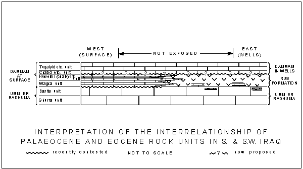
Click on the image to enlarge it.
Remarks.- The stratigraphic position of the Rus formation, which is unknown at outcrop in southern Iraq, is difficult to define. However, the ages of the overlying Dammam formation and of the underlying Umm er Radhuma formation depend on the age accepted for the Rus.
Both the Dammam formation and the Umm er Radhuma formation have been subdivided for mapping purposes into a number of informal field units.
The Umm er Radhuma formation contains the Ghurra Beds at the base and the Basita Beds at the top.
The Dammam formation is subdivided (see the Remarks on the Dammam formation) into four units, as follows: Tuqaiyid/ Ghanimi / Barbak / Rudhuma unit: Chabd / Shawiya / Huweimi (limestone) unit; Huweimi (chalk)/ Shawiya/ Sharaf unit, and, at the base, the Wagsa unit (See the definition of the Dammam formation for remarks on these units).
None of these units is recognizable in wells lying to the east of the area of outcrops.
In those wells the base of the Dammam formation shows a fauna of Alveolina elliptica (), Nummulites discorbinus (), Nummulites gizehensis and Nummulites lucasanus d'. This fauna is of Middle Eocene age.
This fauna occurs in sediments which rest directly on the Rus formation in the well sections.
The base of the Dammam formation in the field is, however, not characterized by this particular fauna.
There the basal limestones contain a Lower Eocene fauna with Operculina libyca , at the base of the Wagsa Beds.
These Wagsa Beds appear to rest unconformably on the underlying Umm er Radhuma formation without intervention of the Rus formation.
The middle Eocene fauna of the Dammam formation of the wells appears higher up in the Dammam formation in the field, in the limestone facies of the Huweimi (limestone) Beds.
It would seem therefore that the limestones with Operculina libyca fauna of the surface exposures change, towards the offshore area, into strata of the Rus formation as found in the wells.
Similarly, the second unit of the Dammam in the field (the Huweimi-chalk-/ Shabicha/ Sharaf Beds) has no equivalent in the Dammam of the wells, and a facies change into the Rus formation can well be accepted again.
Recapitulating, in the writer's own view it is perfectly possible that the two lower units of the Dammam formation in the field (the Wagsa Beds and the Sharaf/ Shabicha/ Huweimi-chalk-Beds) change facies towards the offshore region into part of the Rus formation as found in the wells.
Both the offshore facies and the shore facies were subsequently covered by a Middle Eocene nummulitic facies, found in the field at the base of the third unit of the Dammam formation: the Huweimi (limestone) / Shawiya/ Chabd Beds. This correlates quite well with the base of the Dammam formation in the wells. This concept of the formations and beds concerned and of their relationship is expressed by the accompanying schematic sketch.
There is at present, no proof that the sketched relationships are correct. The proffered solution seems to be the most logical one, fitting all the available facts. The unconformity between the Wagsa Beds and the Umm er Radhuma has been contested of late. Its existence is not vital to the hypothesis.
There is slight indication of an unconformity between the Rus and the Dammam formation in the wells, where a grey-green shale of approximately seven feet (2.5 metres) thickness occurs near or at the base of the Dammam. No such unconformity appears to have been found in the field, but the lower (chalk) Huweimi Beds contain white or pinkish chalks of fresh-water appearance ( and , unpublished report 1953). On the other hand, the upper (limestone) Huweimi Beds are definitely representative of a marine shoal limestone.
Within these chalks of fresh-water appearance, however, there occur chalky limestones with lamellibranchs. This disturbing factor has not been investigated properly in the field as yet. To date there does not seem to be much reason to doubt the existence of a prominent facies change between lower and upper Huweimi Beds.
The nummulitic Dammam correlates quite clearly between exposures and subsurface occurrences, although the exposures are more varied and subsurface occurrences are rather uniform.
There is, however, another possible explanation for the absence of the Rus formation in the surface sections. It is possible that percolating ground water has removed the anhydrite, so that the apparent unconformity is not an original one. Facies change from Wagsa Beds and lower (chalk) Huweimi Beds into Rus formation remains feasible in this case because the correlation of upper (limestone) Huweimi Beds with the lower Dammam formation in the wells remains probable. The result remains much the same in this case therefore, except that the pre-Wagsa unconformity did not exist originally. As mentioned before, this does not affect the postulations as to lateral relationships which are illustrated above.
(R.C.v.B.).
|
Cretaceous |
Review of Middle East Oil. Petroleum Times (June), pp. 48-62, 87-90, etc.
Obsolete term used by C.T. (1948). See Mauddud formation, Nahr Umr formation. Not Rutbah sandstone formation.
(H.V.D.).
|
Cretaceous |
Authors.- W.T. and A. , 1937; unpublished report.
Synonymy.- "Grès de Rutba", R.C. , 1956.
Type locality and section.-
(Type section selected by F.R.S. , 1940).
Location.- At northeastern end of promontory lying between the Wadi Ubeila and Rutbah, and about 4 kilometres northwest of the settlement of Rutbah, after which the formation is named. The base of the formation is at approximately lat. 33°04'20" N, long. 40°12'50" E.
Brief description of type section.-
Thickness: 23 metres.
Lithology: Vari-coloured, white and ferruginous, coarse to fine sands and sandstones, locally cemented to quartzites. Basal parts possibly of continental origin, upper parts marine.
Fossils: None found.
Age.- Pre-Cenomanian or early Cenomanian, since overlain by Upper Cenomanian M'sad formation. Post-Triassic or Upper Triassic, since underlain unconformably by Upper Triassic Mulussa formation. Age not ascertained within these limits at the type locality. For age determination on evidence of regional correlations see Remarks below.
Underlying formation and details of contact.- Mulussa formation; contact unconformable, erosional, discordant.
Overlying formation and details of contact.- M'sad formation; contact transitional, gradational, taken at the base of the first definite limestone bed above the continuous sandstones of the Rutbah sandstone.
Other localities.- Widely exposed around Rutbah and as isolated remnants overlying the Mulussa limestone plateau, to the east of Rutbah. In the Wadi Hauran, east and west of Muhaiwir.
Remarks.- The Rutbah sandstone transgresses over an extensive eroded surface which exposes Bathonian Muhaiwir formation in the eastern Wadi Hauran, and Ga'ara sandstone of probably Middle Triassic age in the western part of the Ga'ara depression area. The formation is about 18 metres thick in the vicinity of the type section, but pinches out rapidly to the north and northwest, between the Ga'ara sandstone and the M'sad formation. It thickens considerably to the east, where it is unconformably overlain by Miocene limestone around and east of Muhaiwir. It is homotaxial with the
"grès lignitifère" of G. , and with the so-called "Nubian sandstone" of the Lebanon, etc. It has been loosely equated with the Nahr Umr formation of the subsurface sections, with which it may be continuous, but it seems much more probable that these two units are genetically distinct and that the Rutbah sandstone lies over the eroded outcrops of the Nahr Umr in the area of no exposures lying between Muhaiwir and the Awasil area (Plates III ![]() and
IV
and
IV ![]() ).
).
Whereas the Nahr Umr formation is considered to be of early Albian age, grading upwards into the late-Albian Mauddud formation, the Rutbah sandstone is probably of Cenomanian age at its type locality, where it is overlain by the Upper Cenomanian M'sad formation. The M'sad formation is probably approximately age-correlative with the Mahilban limestone of the Awasil area, and the Rutbah sandstone at Rutbah is probably of the age of part of the non-sequence between the Mauddud and Mahilban formations at Awasil. This interpretation is preferable to the earlier-held concept of the Rutbah - Nahr Umr formations as comprising a single diachronous sandstone deposit.
The Cenomanian age for the upper part of the sandstone is argued from the fact that it grades upwards into the M'sad formation, which is considered to be of Upper Cenomanian age on the evidence of gastropod, rudist and foraminiferal faunas. Cenomanian age for the base of the formation at Rutbah is speculative. The lateral relationships of the Rutbah sandstone and the M'sad formation are obscure. The latter includes variable sandstone and sandy limestone tongues which may interdigitate laterally with the Rutbah sandstone proper: because of uncertainty as to this relationship, the sandstone tongues in the M'sad are excluded from the Rutbah sandstone and considered to be components of the M'sad formation.
The Rutbah sandstone, which overlies the Bathonian Muhaiwir formation in the Wadi Hauran around and east of Muhaiwir, at one time was considered to be of Aquitanian-Oligocene age in that area, the confusion arising through misdating of the coral fauna of the Muhaiwir formation as Oligocene. The name "Hauran sandstone" ("Hauran quartzite") was informally applied to the sandstone during this period of misunderstanding, and though never defined or published, this name has been fairly widely utilized for sandy sediments, which do actually occur below the Lower Miocene limestones in other areas. The unpublished "Hauran sandstone" is a junior synonym for the Rutbah sandstone, and its use is now abandoned: it should not be confused with the "Zor Hauran formation", which is now formally defined as the rock-unit which intervenes between the (Triassic) Uba'id formation and the (? Upper Triassic) Mulussa formation, in the Wadi Hauran, below the Rutbah sandstone, west of Muhaiwir.
The name Rutbah (or Rutba) sand (or sandstone) was formerly applied to the Nahr Umr formation of southern Iraq, and also to those units of the Kuwait succession which are now designated, collectively, the Burgan sub-group ( and , 1958). For the most part, such usage was confined to unpublished reports of Oil Companies, etc., but C.T. (1948) included in his publication a stratigraphical table for the Kuwait succession which groups the Ahmadi, Wara, Mauddud and Nahr Umr formations of current classifications as subdivisions of the Rutbah Sand.
(H.V.D.).
|
Miocene |
Informal marker limestones in the Saliferous Beds (informal subdivision of the Lower Fars formation in the Kirkuk structure). See Lower Fars formation.
(R.C.v.B.).
|
Cretaceous |
Author.- P.M.V. , 1952 (unpublished report).
Synonymy.- "Sa'di formation", R.M.S. and S.N. , 1958.
Type locality and section (from and , 1958).-
Location.- B.P.C. Well Zubair No. 3;lat. 30°23'01" N, long. 47°43'29" E; elevation 51.9 feet; completed 21.2.51. The formation lies between drilled depths 6013 and 6943 feet.
Brief description of type section.-
Thickness: 930 feet.
Lithology: White, chalky, marly, globigerinal limestone with a well developed marl bed, distinguished in the nomenclature as the Hamrina marl member, lying between drilled depths 6570 and 6765 feet.
Fossils: Very fossiliferous, with species of Nodosaria, Palmula, Marginulina, Cristellaria, Globotruncana, Gümbelina, etc.
Age.- Upper Senonian ( and , 1958).
Underlying formation and details of contact.- Tanuma formation; contact conformable, at top of black calcareous shale and at the base of white, chalky, limestone.
Overlying formation and details of contact.- Hartha formation; contact an erosional unconformity.
Other localities.- All deep well sections in the Basrah oilfields area. Recognized also in K.O.C. wells at Radhautain, Bahra, etc., in northeastern Kuwait ( and , op. cit.).
Remarks.- The Sa'di formation is not recognized in southeastern Kuwait where the equivalents of this and the underlying Tanuma and Khasib formations are probably represented by the Gudair formation in areas of full development of the latter. However, the Gudair thins very markedly over structural highs, partly as a result of erosion of its upper parts at the Bahra/ Gudair unconformity. The Bahra is considered to be the equivalent in southeastern Kuwait of the Qurna and Hartha ( and , 1958; A.F. , 1957).
Although and (1958) indicate that the contact of the Sa'di with the overlying Hartha formation is conformable in the Basrah area, recent work by E. (unpublished report) has shown that this contact is an erosional unconformity, corresponding with that already noted between the Bahra and Gudair formations in Kuwait ( and , op. cit.).
In structural depressions, where the erosional cut-out is smallest, the upper part of the Sa'di formation includes organic detrital limestones with a characteristic microfauna including Pseudedomia complanata and , Cuneolina cylindrica , Archaecyclus midorientalis and and Rotalia skourensis . This limestone, recognized informally as the "Pseudedomia complanata limestone" is absent over the crests of structural uplifts of Cretaceous age. The same faunal association occurs in the Gudair formation of southeastern Kuwait, and in the Pilsener limestone of northern Iraq in wells west and south of Mosul. In the latter area the fauna is determined as of Upper Campanian age since it occurs above limestones with Monolepidorbis spp., Cosinella sp., Pseudosiderolites heracleae () and Globotruncana stuarti (de ).
"Basinwards, as in Nahr Umr No. 2 well, the sequence becomes practically all marl with only a few marly limestone beds. Southwards towards Kuwait the Sa'di is well developed in Bahra No. 1 between 5025 and 5600 feet, but thins out considerably towards Burgan and eventually disappears. In the Basrah area its thickness varies between 315 feet (Nahr Umr) and 1279 feet (Rumaila)" (R.M.S. and S.N. , 1958).
The Sa'di formation, the overlying Hartha and Qurna and the underlying Tanuma and Khasib formations are not recognized in northern Iraq. The more neritic components of these units have equivalents of close comparability within the Pilsener limestone formation of M.P.C. wells lying between Fallujah-Awasil and Alan. The Hartha/Sa'di break of the Basrah area is certainly present as an intraformational break of some importance within the Pilsener limestone of the Fallujah-Awasil area. This unconformity may also be related to that which is present locally, between the Aqra and Bekhme limestones, in the mountain-fold zone of northeastern Iraq.
The dominantly globigerinal portions of the Sa'di, Qurna and Khasib formations are closely comparable with parts of the Shiranish formation of northern Iraq, of which they might be considered to be out-lying tongues.
(H.V.D.).
|
Miocene |
Informal unit of the Lower Fars formation.
See Lower Fars formation.
(R.C.v.B.).
|
Palaeocene-Eocene |
Discarded term, used by Iraq Petroleum Company geologists in unpublished reports. Used in a published report (Anon., 1955).
See Kolosh formation.
(R.C.v.B.).
|
Jurassic |
Author.- R. , 1948; unpublished report.
Synonymy.- None.
Type locality and section.-
Location.- Surdash anticline, Sulaimaniya District, northeastern Iraq. The type section is in the course of the stream which flows northwards through Sargelu village; the base lies about 280 metres north of the stream confluence at Sargelu, and the top about 430 metres north of this confluence, at approximately lat. 35°52'44" N; long. 45°9'25" E.
Brief description of type section.-
Thickness: 115 metres.
Lithology: Thin-bedded, black, bituminous limestones, dolomitic limestones and black, papery shales, with streaks of thin black chert in the upper parts.
Fossils: In uppermost 12 metres: Posidonia ornati , ? Posidonia somaliensis , oppelids, Parkinsonia sp., Stephanoceras sp., occasional plant remains. In next lower 21 metres: poor impressions of ammonites. In lowermost 82 metres: Rhynchonella curviceps (non ), Rhynchonella cf. rosenbuschi and , Rhynchonella de lottoi , Posidonia cf. opalina (), Gryphaea cf. balli (), "Hammatoceras" sp. indet., leptolepid (? Thrissops sp.).
Age.- Bathonian at top, uppermost Liassic at base.
Underlying formation and details of contact.- Sehkaniyan formation; contact conformable and gradational, taken at the top of massive-bedded, brown-weathering, dolomitic limestone, and below thinner-bedded, blue-weathering, cherty, brittle, laminated limestones.
Overlying formation and details of contact.- Naokelekan formation; contact apparently gradational and conformable, taken below thin-bedded, highly bituminous contorted beds without chert, and above thin-bedded black limestones with abundant chert and abundant Posidonia ornati.
Other localities.- All sections in Kurdistan which expose the Jurassic, including measured and sampled sections at Sirwan, Sehkaniyan, Qal'Gah, Rania, Naokelekan, Kurrek, Rowanduz Ru Kuchuk, Isumaran, Chia Gara, Ser Amadia, Ora, Chalki, Shiranish, Banik, etc. Subsurface sections, west of the Tigris, in M.P.C. Wells Ain Zalah No. 16, Gullar No. 1, Butmah No. 2, Atshan No. 1, Alan No 1, Adaiyah No. 1, Ibrahim No. 1, Qalian No. 1, Najmah No. 29, Makhul No. 2, Mileh Tharthar No. 1. Also in Kuwait in K.O.C. Well Burgan No. 113.
Remarks.- The Sargelu formation is defined to include the sequence of thin-bedded, foul-water, calcareous-argillaceous sediments which occupies, in Kurdistan, the section between the highly bituminous Naokelekan formation (above) and the massive dolomites of the Sehkaniyan formation (below).
The lower boundary, with the Sehkaniyan, is generally sharp, but may be obscured by extensive dolomitization of the lower beds of the Sargelu (as at Ora and Ser Amadia). In such cases the accepted lithological limit between Sargelu and Sehkaniyan formation may be significantly diachronous over small distances. Where the complication of dolomitization of the Sargelu is absent, the base of the formation is probably more or less isochronous over the whole of northern Iraq.
The upper boundary of the Sargelu is placed within a succession of essentially similar thin-bedded limestones, but can be closely defined, in every studied section, by the absence of chert and abundant Posidonia from the overlying Naokelekan and by the extremely bituminous and usually contorted nature of the lower beds of this formation.
The Sargelu is of Middle Jurassic age at its top, and the Naokelekan is a highly condensed succession of Upper Jurassic age. Although no unconformity has been observed at outcrop, and ammonite evidence for presence of most of the Upper Jurassic stages from ? Callovian to ? Lower Kimmeridgian has been gleaned from various localities of the Naokelekan, it is possible that several non-sequences are involved within this formation, and also that the contact of Naokelekan on Sargelu is non-sequential, with most of the Callovian unrepresented by sediments.
In M.P.C. well sections Najmah No. 29 and Qalian No. I, Mileh Tharthar No. 1 and Atshan No. 1, there is erosional unconformity between the Sargelu formation and the overlying Najmah formation, which must correspond broadly in age with the Naokelekan.
The Sargelu formation of the Kurdistan exposures can be correlated closely, subdivision by subdivision, from locality to locality, over a distance of more than 350 kilometres. The facies is constant throughout, thicknesses varying progressively from 125 metres in the southeast (Sirwan) to about 20 metres hi the northwest (Ora and Chalki regions).
At Ru Kuchuk, the lower part of the Posidonia- and chert-bearing division of the Sargelu is markedly silty, and contains plant impressions of the Bradyphyllum-Pagiophyllum group, cf. Pagiophyllum expansum (), indicating proximity to emerged land to the northeast.
The Sargelu, in sections other than the type, has yielded numerous ammonites, including perisphinctids, reineckeiids, morphoceratids, Oppelia spp., Amoeboceras sp., Stephanoceras sp., etc., mostly from the upper part of the formation. A large ichthyosaurid (not yet identified) has been collected from within the lower Rhynchonella-bearing beds.
In subsurface sections of M.P.C. wells, north and west of Mosul, the Sargelu formation is eroded, and overlain unconformably by Aptian (or ? Albian) Sarmord formation. The amount of erosional cut-out at the top of the Sargelu varies considerably from section to section. The Posidonia-bearing beds are well developed, (though absent in some well sections, presumably due to erosion). The thicknesses of the Sargelu found in the wells considerably exceed those measured in the area of outcrop, being greatest in the south (350 metres in M.P.C. well Najmah-29).
In all wells which have passed through the Sargelu, the formation is conformably and gradationally underlain by the anhydrites and fluffy-textured limestones of the Alan anhydrite, the correlative in subsurface sections of the upper, dolomitic division of the Sehkaniyan formation.
The Sargelu is readily identifiable in well cuttings from the ubiquitous occurrence of the problematical fossil figured by J. and V. (1951, Pl. VIII, fig. 2) and regarded by these authors as debris of filamentous algae.
The name Paleotrix has been proposed for these supposed algae by F. (1956), who notes their presence in the Lias of Cimolais (Udine) and of the Alpi Feltrini.
In Aquitaine, according to and , the profuse relics of this widely distributed organism, whatever its affinities, are found in rocks of late Middle Liassic to Upper Jurassic age. In all studied sections in northern Iraq they characterize the Middle Jurassic Sargelu formation, and they are absent or only rare in Upper Jurassic and Liassic rock-units. But their value as age-indicators is reduced slightly by the fact that they occur also, in great abundance, over a restricted vertical range, in the Upper Triassic Kurra Chine formation.
In many subsurface and some surface sections, such ? filamentous algae and undeterminate scattered Radiolaria, Ostracoda and minute frondicularids and nodosarids are the only fossils noted through the greater part of the Sargelu. This assemblage is extremely widespread, and seldom lacking, except near the base of the unit. In surface exposures of the formation, details of the biofacies are often obscured by dolomitization.
In the Wadi Hauran exposures of the western desert area, sediments contemporaneous with the upper part of the Sargelu are in sandy, oolitic-pseudo-oolitic facies, with rich echinoid-coral-brachiopod-foraminiferal faunas. The rocks are included in the Muhaiwir formation. They are not acceptable within the definition of the thin-bedded, shaly Sargelu formation, which was deposited in a euxinic environment very different from that which supported the flourishing neritic faunas of the Muhaiwir.
Wells in the Basrah area of southern Iraq have not reached as deep as the Middle Jurassic succession. But close correlatives for the Sargelu formation have been recognized in the Kuwait Oil Company's deep test Well Burgan No. 113, where they occupy most of the drilled depth range 10136 to 11066 feet. In this well section the euxinic Posidonia-bearing shales and limestones equivalent to the Sargelu embrace two tongues of pellety neritic limestones (10271 to 10335 and 10455 to 10463 feet, drilled depths) which in the Iraq classification would be interpreted as tongues of Muhaiwir formation.
(H.V.D.).
|
Jurassic |
Author.- R. , 1952, unpublished report.
Synonymy.- None.
Type locality and section.-
Location.- Chia Gara, south of Amadia, North Iraq. The type section runs 170° E from a point about 200 metres west of Baluti village (i.e. from about lat. 36°59'37" N; long. 43°28'16" E), up a stream course which drains the southern (strike) slope of Chia Gara (elevation 7298 feet). The top of the formation lies about 600 metres south-southwest of Baluti.
Brief description of type section.-
Thickness: 303 metres.
Lithology: Upper division of 181 metres.- Soft, grey dolomites, highly cavernous, and weathering into massive beds of "cargneule" type, alternating with soft, featureless, friable, cherty dolomites, and with grey and yellowish shales and blocky marls with melikaria (box-work structures). Lower division of 122 metres.- Thin-bedded, cherty and dolomitic limestones, fine-grained to porcellanous, pale grey, weathering whitish, alternating with friable, cherty shales, and occasional dark, sugary dolomites. Also commonly-occurring thin bands of shell-breccias, oolitic limestones, microconglomerates, and recrystallization breccias. Dark brown, massive-bedded dolomites at base.
Fossils: The upper division contains only rare Archaediscus sp., ? Problematina, minute gastropods, fish debris and ? algal elements, etc. The lower division carries a similar fauna, with ? Trocholina sp., Glomospira spp., etc., and also thin beds crowded with cyrenids, cf. Eomiodon indicus .
Age.- Liassic (possibly including part-Rhaetic, but regarded as Liassic only, by convention).
Underlying formation and details of contact.- Baluti shale formation; contact conformable and gradational, taken at top of interbedded green and grey shales and dolomitic limestones, and at base of dark brown massive dolomites which constitute the lowest feature-forming unit in the Sarki.
Overlying formation and details of contact.- Sehkaniyan dolomite formation; contact conformable, taken at base of dark brown, massive dolomite unit, 60 metres thick, and at top of splintery, yellow-green shales with limestones.
Other localities.- Sirwan Gorge, Qal'Gah, Surdash, Sehkaniyan, Rania, Naokelekan, Barsarin, Chia Gara, Ora, Chalki area, Shiranish, etc.
Remarks.- The Sarki formation is a succession of rapidly alternating evaporitic and oolitic-chemical limestones with argillaceous intercalations, which differs in minor details, rather than in fundamental characters, from the succeeding Sehkaniyan formation, and from the underlying Baluti shale and older Kurra Chine, and Geli Khana formations.
It is set apart from the underlying Baluti shale formation by the green colour and predominantly shaly character of the Baluti, which stand in marked contrast to the more massive-weathering, dark-brown, lower, dolomitic beds of the Sarki.
It is also differentiated readily from the Sehkaniyan by colour differences and by weathering habit, but in this instance it is the Sehkaniyan which is contrastingly massive-bedded and dark brown, and the Sarki which is shale-containing and of lighter colour.
Although no gypsum is seen at outcrop in the type Sarki, its original frequent presence is indicated by the prevalence of box-work structures and "cargneules" (dolomitic skeletons left after removal of soluble minerals by solution).
In the Sirwan gorge section, the limits of the Sarki are not readily identifiable, but the unit as a whole is characterized by contorted dolomites, residual solution rubble, and rare undissolved gypsum lenticles.
At Rania, the formation is represented by 231 metres of soft, cavernous, featureless dolomites and brecciated limestones (which are probably brecciated following solutional loss of originally interbedded gypsum).
The Shiranish section shows about 232 metres of dark dolomites, with residual breccias at the base of the section, yellowish marls towards the top, and an olive-green, shale-dominated interval in the middle of the unit.
In the type and several other sections, the lower parts of the unit, where containing Eomiodon spp., etc., are distinguished as the "Cyrenia beds". Although the "Cyrenia beds", as a whole, can be correlated from section to section, the upper and lower boundaries are not always clear and sometimes appear to be markedly diachronous. The apparent diachronism is in part a consequence of alternation by dolomitization, which is manifested to various degrees in different parts of different sections.
Though most "cyrenids" are confined to fresh or brackish-water habitats, Eomiodon is considered to be marine (L.R. , 1935). The "Cyrenia beds" contain Spongiostroma sp. at Naokelekan, and the rare Foraminifera, distributed through the formation, indicate a marlne environment throughout.
The age of the Sarki formation is not firmly established. The Eomiodon fauna is the only internal indication as to age, and none of the represented species, of which there are probably several, is firmly identified with Eomiodon indicus . Eomiodon indicus was first described from the Kioto limestone of Attock, from beds at first considered to be of uppermost Triassic or lowermost Jurassic age, but later redetermined as intra-Liassic.
The underlying Kurra Chine is dated as Upper Triassic, perhaps including part-Rhaetic in its upper portion.
The overlying Sehkaniyan contains an ill-dated Lithiotis-Spiriferina fauna, akin to and probably correlative with that which is regarded as being of early Liassic age in southwestern Persia (P.E. , F.C. and A.N. , 1951), in association with a foraminiferal fauna (Haurania sp., Lituola sp., and ? Nubecularia pellets) which is more likely to be uppermost Liassic or early Bajocian than early Liassic. The Middle Jurassic alternative is excluded, because late Liassic age has been attributed to Rhynchonella and Posidonia faunas from the base of the Sargelu formation, which lies conformably upon the Sehkaniyan.
For purposes of plate-portrayal, and purely as a convention, it is accepted that the Baluti shale formation is of Rhaetic age, that the Kurra Chine formation is of Upper Triassic age, and that the Sarki formation and succeeding Sehkaniyan are of Liassic age (excluding the uppermost part of the Liassic, which is represented in the basal beds of the Sargelu), the "Lithiotis limestone" division of the Sehkaniyan being shown as Lower Toarcian (see: Sehkaniyan formation).
The Sarki formation is not recognized in the outcrops of the Wadi Hauran, in the western desert of Iraq, but it may be correlated with the somewhat similar and probably more or less contemporaneous Uba'id formation (part). However, the Uba'id and Sarki formations are sufficiently dissimilar in gross and in fine lithological characters to justify the retention of both names in the stratigraphic classification.
The Butmah formation, of deep subsurface sections west of the Tigris, is homotaxial with the Sarki, in that it lies above the Baluti formation and below the Adaiyah anhydrite formation which is firmly correlated with the basal dolomitic unit of the Sehkaniyan.
The Butmah and Sarki are maintained as separate formations, despite a fair degree of similarity in the general range of variation in lithology shown by the units, because the Butmah has consistent characteristics in subsurface sections which are not matched in the outcropping formation.
Thus the Butmah contains thick-bedded anhydrites and fluffy-textured chemical limestones, numerous marker-type oolitic, pseudo-oolitic and pellety limestones, bedded chert (locally), and a persistent slightly arenaceous component which are absent from the Sarki. Primary dolomites are common in the Butmah, but secondary dolomites are rare. On the other hand, secondary dolomitization is a rather persistent feature of the Sarki. The "Cyrenia beds", which characterize the lower part of the Sarki, have not been observed in the subsurface unit.
Nevertheless the Butmah and Sarki contain in common a sufficient number of highly characteristic lithofacies variants to add considerable support to the homotaxial correlation of the units.
The Butmah formation is thicker, in most wells in which it has been found, than is the Sarki formation at its thickest known development at Sirwan (ca. 450 metres). Subsurface thicknesses of the Butmah average 500 metres, but the Sarki exceeds 200 metres only in a few sections.
(R.W.)
|
Cretaceous |
Author.- R. , 1950, unpublished report.
Synonymy.- None.
Type locality and section.-
Location.- Surdash anticline, Sulaimaniya District, northeastern Iraq. The type section is made up in two different areas. The upper 182 metres of the formation are exposed in the Qamchuqa Gorge section, with the lowest exposure in the vicinity of Sarmord village (lat. 35°54'18" N; long. 43°2'7" E) and the top of the formation some 250 metres southwest of the village, at the foot of the massive limestone scarp of the Qamchuqa formation. The lower 273 metres are described from the section in the course of the stream which flows northwards through Sargelu village. The top of this part of the section (corresponding to the base of the section exposed at Sarmord) lies about 1 kilometre north of the village (lat. 35°52'54" N; long. 45°9'28" E) and the base of the formation is exposed about 800 metres north of the village.
Brief description of type section.-
Thickness: 455 metres.
Lithology: Brown and bluish marls, buff weathering, with alterations of marly neritic limestones.
Fossils: Uppermost 80 metres: Astrocoenia sp. nov. MS., Heteraster couloni , Heteraster oblongus var. musandamensis , Pholadomya cf. esmarki ., Potamides phillipsi , Trochus sp., etc. Choffatella decipiens , etc., Actinoporella sp., Permocalculus inopinatus , etc., Salpingoporella cf. muhlbergi (). No significant fauna in lower 375 metres.
Age.- Barremian at top, Hauterivian at base.
Underlying formation and details of contact.- Balambo formation; contact conformable and gradational, taken at the base of buff-weathering unfossiliferous marls and at the top of thin-bedded, grey weathering ammonitiferous limestones with shales.
Overlying formation and details of contact.- Qamchuqa limestone formation; contact gradational and conformable, placed at base of continuous neritic limestones.
Other localities.- Shiranish Islam, Chia Gara, Ser Amadia, Banik, Rowanduz gorges, Kurrek, Hadiena, Rania, Pir-i-Mugurun, etc. Subsurface localities include I.P.C. Well Kirkuk No. 109; M.P.C. Wells Ain Zalah Nos. 6 and 19, etc. Butmah No. 2, Gullar No. 1, Sasan No. 1, Gusair No. 1, Alan No. 1, Ibrahim No. 1, Atshan No. 1, Adaiyah No. 1, Najmah No. 29, and Makhul Nos. 1 and 2.
Remarks.- The Sarmord was defined to include the succession of neritic to deep-water marls and associated neritic limestones, which intervene, in the sections of the Surdash-Rania-Rowanduz area, between the thin-bedded, ammonitiferous, radiolarian limestones and shales of the Balambo formation, below, and the massive organic-detrital limestones of the Qamchuqa formation, above. However, typical Sarmord formation sediments are found over an area greatly exceeding that in which the formation was first defined, and the unit is now recognized in a variety of settings in most of the studied parts of northern Iraq.
The formation passes, eastwards from the type area, into the continuous body of the "bathyal" Balambo formation. The passage is usually gradational, and by intercalation, so that in some areas it may be necessary to recognize a complicated succession of intertonguing components of the two formations, or else to differentiate a transition zone of mixed formations (treated in the naming by hyphenation, thus: Balambo formation- Sarmord formation). Similarly gradual or alternating passage may be encountered in vertical sections, -- where the Sarmord passes downwards by alternation into Balambo formation. Again, a transition zone of mixed formations may require recognition, (expressed in the nomenclature, in this case, as "Sarmord/ Balambo formation").
The Sarmord also grades upwards into the massive neritic Qamchuqa limestone formation, and since the Sarmord itself may include tongues or lentils of neritic limestones, there may be doubt, locally, as to the precise position in the succession -- which should be chosen as the lower limit of the Qamchuqa and as the top of the Sarmord. Occasionally the marl components of the Sarmord may wedge out to negligible streaks, producing a near-continuous body of neritic limestones which is more realistically identified with the Qamchuqa limestone formation than with the laterally-equivalent Sarmord. Thus, as at Bekhme, the Qamchuqa may directly overlie Balambo formation.
In the Amadia area, and in some other localities, a sandy, oolitic, reef-type limestone unit, of Valanginian-Hauterivian age, occurs below the Sarmord, and above the Tithonian-Berriasian Chia Gara formation. This oolitic-organic detrital unit is separately recognized, as the Garagu formation. The transition from Garagu upward into Sarmord is usually gradational and conformable, but at Banik the Garagu is overlain unconformably by Qamchuqa limestone formation, the Sarmord formation vanishing convergently into the break between late Barremian or early Aptian Qamchuqa and early Hauterivian Garagu.
In I.P.C. Well Kirkuk No. 109, the Garagu formation appears as a tongue within the Sarmord formation, into which it grades both upwards and downwards. The upper division of the Sarmord, here exceptionally calcareous, occupies a normal position between Garagu formation, of Valanginian-Hauterivian age, and Aptian-Barremian Qamchuqa. The lower division of the Sarmord carries a fauna of the Pseudocyclammina kelleri faunizone (early Valanginian-Berriasian) near its top, and a probably Berriasian microfauna, with Spirocyclina, in intensely glauconitic, conglomeratic, gastropodiferous, marly limestones at its base.
The underlying formation in this section is the Karimia mudstone, which is deemed to be of Berriasian (and ? Tithonian) age: the contact of Sarmord on Karimia formation is considered to be unconformable, though without angular discordance. The break is considered to lie within the Berriasian, and the section provides the record of greatest known age for the base of the Sarmord formation. The lower "tongue" of the Sarmord in Kirkuk Well No. 109 is believed to pass laterally and gradationally, southwest-wards, into the Berriasian-Valanginian Zangura formation of Makhul wells, etc.
In M.P.C. Wells Najmah No. 29 and Makhul Nos. 1 and 2, the Sarmord is found as a neritic marly limestone unit, lying below the Shu'aiba formation (which comprises neritic limestones or dolomites of Aptian age, here representing the Qamchuqa formation of the area to the north and east). In Najmah No. 29 the Sarmord passes downwards, directly, into detrital limestones of the Garagu formation, which is here transgressive over eroded pre-Kimmeridgian Najmah formation. In Qalian Well No. 1, the Shu'aiba, Sarmord and Garagu formations are cut out in the Cretaceous / Jurassic unconformity.
The Makhul wells show a thin development of sandy Zubair formation below the Sarmord and above the Garagu, and in the area to the west and south the entire Sarmord formation is replaced, laterally, by the Zubair formation sands.
In Makhul and Najmah the Sarmord is principally of Barremian age, though possibly including early Aptian and late Hauterivian. It carries locally rich foraminiferal faunas (Cyclammina spp., Choffatella decipiens , etc., with Orbitolina cf. discoidea in the upper parts).
North of Qalian, in M.P.C. well sections at Ain Zalah, Butmah, Sasan, Ibrahim, Alan, Atshan, etc., the Sarmord, as a marl formation with neritic limestone components, is the basal transgressive unit of the Cretaceous rock sequence. It lies on an eroded surface which exposed pre-Kimmeridgian Najmah formation (in Atshan No. 1) to Middle Jurassic Sargelu formation (in other cited wells), and it carries a poor Orbitolina fauna, with Orbitolina cf. discoidea . The age of the Sarmord, in this area and setting, is Aptian or perhaps even early Albian. It passes upwards, gradationally, into Albian Qamchuqa formation.
In Alan Well No. 1, the upper part of the Sarmord is replaced gradationally by the geographically restricted Rim siltstone formation.
In the exposed areas of Kurdistan the lateral passage into Balambo formation downwards and northeastwards, into Garagu formation downwards and (in general) northwestwards, and into Qamchuqa formation upwards, confers upon the boundaries of the Sarmord a degree of diachronism which is unusual in northern Iraq. Thus, the facies- and formation-change, from neritic marls of the Sarmord into "bathyal" shales, etc., of the Balambo formation, occurred in Albian times at Naokelekan, in Hauterivian times at Sarmord, and in Valanginian times at Rania, whilst neritic marls attributed to the Sarmord were first deposited in Berriasian times in the Kirkuk area.
The sections of Ser Amadia and Chia Gara include Sarmord formation, here of only about half the thickness found in the type section, but straddling a very different and probably greater time range. The uppermost beds of the Sarmord are of Aptian (or even perhaps Albian) age, with Orbitolina cf. discoidea , Cuneolina pavonia var. parva , Pseudochrysalidina sp., etc., this fauna being associated here with scattered sand grains. At the base of the formation, and above the Garagu, occur limestones and marls with a rich fauna, including Heteraster cf. oblongus , H. couloni () var. depressus var. nov. MS., Strombus cf. incertus d', Opis cf. neocomiensis d', Choffatella decipiens , Cyclammina cf. greigi , Pseudocyclammina cf. lituus (), etc. This Barremian fauna, from the base of the unit at Chia Gara, is similar to and of the same age as the fauna from the top of the Sarmord in the type section.
The lower parts of the "Ammonite shale group" of Khumi in southwestern Persia, described by P.E. , F.C. and A.N. (1951), are closely comparable with the Sarmord formation as here defined: there can be but little doubt that the formations are correlative. Orbitolina and Heteraster beds, reported by (1951) from Hakari, 50 kilometres northeast of Ora, from shaly and marly limestones, include faunas which match those found in the type Sarmord and at Chia Gara: these beds are certainly to be considered as correlatives of the Sarmord formation.
In southern Iraq the place of the Sarmord formation in the succession is taken by the Zubair formation and by the upper part of the Ratawi formation into which the basal beds of the Zubair of the Awasil area pass, laterally, towards Basrah.
(R.W. and H.V.D.).
|
Permian |
Author.- R. , 1950; unpublished report.
Synonymy.- None.
Type locality and section.-
Location.- On northern slope of ridge lying between the Geli Khana above Ora, and the Ora cirque, in beds dipping northwards. The base of the member lies about 1.6 kilometres due north of the Ora Police Post (lat. 37°16'38" N, long. 43°21'37" E).
Brief description of type section.-
Thickness: 61 metres.
Lithology: Featureless, vacuolar dolomites with recrystallisation breccias and recrystallized, dolomitic marls with blockwork. Some thin bands of silicified limestone at base, containing microfossils.
Fossils: Microfauna, not yet determined; microflora includes the alga Epimastopora minima (1956a), from close to the base of the member.
Age.- U. Permian, as for the remainder of the Chia Zairi limestone.
Underlying formation and details of contact.- Lower part of the Chia Zairi limestone; conformable.
Overlying formation and details of contact.- Upper part of the Chia Zairi limestone; conformable.
Other localities.- Jebel Satina, northeast of Ora; Chia-i-Zinnar, at Harur, Kaista, etc.
Remarks.- The Satinah member is defined to include the succession of evaporites and dolomites which was precipitated, presumably during temporary closing of connection with the open sea, in the middle of the Chia Zairi rhythmic subsidence. The presence of residual recrystallisation breccias and dolomitized marl with block work suggests that these sediments were originally associated with anhydrite which has later been dissolved at outcrop. Some sand occurs at the base of the member at Harur, where the thickness is 77 metres.
The general picture visualized is that of normal, shallow sea conditions in the lower half of the Chia Zairi. Coral-reef growth, shoaling or tectonic warping (?) divided the sea bottom into different basins, impeded circulation, and limited inflow from the ocean. Evaporite deposition began, and continued until subsidence was sufficiently increased to re-establish connection with the open sea.
The member is excellently exposed in the southwestern scarps of the Jebel Satina, northeast of Ora, from which locality the name is derived.
(R.W.).
|
Cretaceous |
Fractured Reservoirs of Middle East. Bull. Amer. Assoc. Petrol. Geol., vol. 38, n° 5, pp. 774-815, figs. 1-12.
Author.- E.J. , 1954, pp. 784-786.
This name, in current use for the lower of the two producing reservoirs in the Ain Zalah oilfield of northern Iraq, is not truly a stratigraphic term, since it is determined by the distribution of producible oil within the crestal part of the Ain Zalah anticline, in the Qamchuqa and Mushorah formations and in the lower part of the Shiranish formation. Nevertheless, there is an inevitable tendency to apply the name, loosely, as a stratigraphical term, to the Qamchuqa formation wherever situated and whether or not oil-containing.
(H.V.D.).
|
Cretaceous |
Informal name, applied in the Zubair field and other fields in the Basrah area of southern Iraq, to porous oil-containing limestones within the Mishrif formation. Although not a stratigraphical unit, since defined on the presence or absence of oil within a limestone formation, there is an inevitable tendency for the term Second Pay to be applied as a substitute for Mishrif formation in informal reports and perhaps in publications.
(H.V.D.).
|
Jurassic |
Authors.- R. and D.M. , 1950; unpublished report.
Synonymy.- None.
Type locality and section.-
Location.- Surdash anticline, Sulaimaniya District, northeastern Iraq. The type section is in the stream, lying 1 kilometre southwest of Sehkaniyan village, and the top of the formation lies in the main stream valley, at approximately lat. 35°52'55" N; long. 45°8'0" E.
Brief description of type section.-
Thickness: 180 metres.
Lithology: Upper division of 51 metres: dark, foetid, saccharoidal dolomites and dolomitic limestones, locally with chert. Middle division of 44 metres: organic and pellety limestones, locally dolomitized, with silicified fossils and some chert, in beds of thickness 1 metre (towards top) to 20 cm. (towards base); dark blue to dark brown at top, greenish grey at base. Lower division of 85 metres: dark, saccharoidal dolomites and subordinate dolomitized limestones, with pseudobreccias (probably replacing solution-brecciated gypseous marls) at top.
Fossils: Indeterminate gastropod and lamellibranch vestiges, locally, in upper and lower dolomite divisions. The middle division is fairly richly fossiliferous and has yielded Lithiotis sp., Spiriferina sp. cf. S. ampla , Spiriferina spp., Zeilleria sp., gastropods indet.; echinoid debris indet., Haurania sp.; Lituola sp., lituolids indet., trochamminids indet., cristellarids indet., Glomospira spp., ? Nubecularia sp. (pellet forming), ostracods: algae, including Boueina hochstetteri var. liasica .
Age.- Liassic, probably Upper Liassic, by regional correlation.
Underlying formation and details of contact.- Sarki formation; contact gradational and conformable, taken at base of dark brown massive dolomite unit, 60 metres thick, and at top of splintery, yellow-green shales with limestones.
Overlying formation and details of contact.- Sargelu formation; contact gradational and conformable, taken at top of massive-bedded, brown-weather ing, dolomitic limestone, and below thinner-bedded, blue-weather ing, cherty, brittle, laminated limestones.
Other localities.- Sirwan Gorge, Chia Gara, Ser Amadia, Ora, Chalki, Shawr valley, etc., and in the cores of many of the anticlines of Kurdistan.
Remarks.- The Sekhaniyan formation is feature-forming unit which is easily identifiable in all the deeper sections of Kurdistan. In all studied sections other than the type section the unit is dolomitized throughout, and it is only in the type section that the middle division is discernible as a fossiliferous limestone unit.
The Sehkaniyan is readily differentiated in the field from the overlying Sargelu formation and from the underlying Sarki formation because of its massive weathering habit and dark-brown weathering colour.
The middle fossiliferous limestone division has been termed the "Lithiotis limestone", and is considered to be possibly correlative with the Lithiotis-bearing limestones recorded from near the base of the Jurassic succession in southwest Persia (P.E. , F.C. and A.N. , 1951, p. 143), which are there taken to indicate Liassic age. Boueina hochstetteri var. liasica was described from the Middle Liassic of Morocco. A fairly late Liassic age is suggested by arguments based on regional correlation.
The overlying Sargelu formation, in the type-section, has yielded Posidonia cf. opalina () and Gryphaea cf. balli (), together suggesting highest Liassic or lowest Bajocian age. Late Liassic (or lowermost Bajocian ?) Rhynchonella spp. have been collected from the lower part of the Sargelu in other sections.
The underlying Sarki formation contains an Eomiodon fauna, which is considered to be of Rhaetic or more probably Liassic age, and the Baluti shale formation which underlies the Sarki is referred to the Rhaetic (though with some dubiety).
Since the Sargelu/Sehkaniyan/Sarki/Baluti sequence is conformable, and since the "Lithiotis limestone" occurs only 51 metres below the base of the Sargelu (which is, at oldest, late Liassic), but 388 metres above the (?) Rhaetic Baluti shale, it is probable that the Lithiotis fauna is of late rather than early Liassic age.
The microfauna is of little assistance in assessing the age of the formation. ? Nubecularia nodules of precisely similar appearance to those found in the "Lithiotis limestone" occur in the Bajocian of Bourgogne (P. , 1953), but are known also, in Iraq, from the Bathonian Muhaiwir formation and from the Permian Chia Zairi limestone.
Haurania sp., which occurs in some abundance in the "Lithiotis limestone", is not identifiable with either of 's species (, 1948), which are most probably of Bathonian age in their type locality.
Whatever the precise ages of the "Lithiotis limestone" and of the containing Sehkaniyan formation may be, the "Lithiotis limestone" division is clearly correlative with the Mus limestone formation, since the microfaunas of these two units match in every particular. The Mus is known only from subsurface sections in wells west of the Tigris. It is overlain by the Alan anhydrite formation and underlain by the Adaiyah anhydrite formation, which are taken to correspond with the upper and lower dolomitic divisions of the Sehkaniyan formation in the type section.
The Mus and the Lithiotis limestone division of the Sehkaniyan both exhibit features suggesting significant freshening of rather highly saline seas. Such freshening episodes in the Persian Gulf-Iraq-Iran region are normally associated with transgressions. In the Arabian sections described by R.A. and M. (1952) and W.J. (1952, 1956) the basal transgressive unit of the Jurassic is the Lower Toarcian Lower Marrat formation.
It is suggested that the Toarcian transgression manifested by the Marrat formation in Arabia is that which is initiated in Iraq and Kuwait by the freshening episode indicated by the facies of the "Lithiotis limestone" and of the Mus limestone. The resulting correlation of the "Lithiotis limestone" with the Lower Marrat is strongly supported by the presence of abundant Spiriferina spp. in both, and by the absence of this genus from other Liassic formations in Iraq. It is accepted, for the purpose of plate construction, that the Mus formation and "Lithiotis limestone" are of Lower Toarcian age.
Though the Mus formation is correlative with the "Lithiotis limestone" of the type section of the Sehkaniyan formation, it is not practicable to subdivide the Sehkaniyan at outcrop, in areas other than the type area, since the majority of sections show a continuous dolomite and dolomitized limestone succession from the top of the Sarki formation to the base of the Sargelu. The Mus formation was already well established in the subsurface nomenclature (unpublished) when its equivalence with the "Lithiotis limestone" of Sehkaniyan was demonstrated. These nomenclature, despite admission that a rather precise correlative, circumstances justify retention of the Mus formation in the in similar facies and lithology, is now known in surface exposures.
The Sehkaniyan formation, as such, is not represented in any known subsurface section.
(R.W. and H.V.D.).
|
Palaeocene-Eocene |
Name formerly applied in unpublished reports by I.P.C. geologists to the phosphatic basal beds of the Umm er Radhuma formation in the Ga'ara area.
(R.C.v.B.)
|
Cretaceous |
See Mushorah formation, and remarks under the entry for Senonian-Upper.
(H.V.D.)
|
Cretaceous |
This age designation has been applied generally, in unpublished reports and occasional published papers (e.g. T.F. , 1952; H.V. , 1955; 1958, MS.; etc.) to rock units of Upper Campanian to Maestrichtian age (see Stratigraphical Index region northwest of Mosul, is not usually included with in the region northwest of Mosul, is not usually included with in the Upper Senonian, though it includes Lower Campanian sediments.
The natural divisions, within the Senonian of Iraq, lie in the middle of the Campanian, which is subdivided by the unconformity between Shiranish formation and the Mushorah formation, and approximately at the Maestrichtian /Campanian boundary, which is marked by local unconformities and non-sequences in several areas.
(H.V.D.).
|
Oligocene-Miocene |
Les gisements de pétrole. Publ. Masson et Cie. Paris, pp. 1-502.
G. used this term from Iran nomenclature first in 1938 to designate what are now known as the formations of the Kirkuk group and the Euphrates limestone formation.
(R.C.v.B.).
|
Cretaceous |
Gisements pétrolifères de l'Irak. Publ. Presses Modernes, Paris, 1933, pp. 1-221, figs. 1-17, 7 tables.
Term from Iran nomenclature used by C.P. (1933). See Imam Hassan limestone.
(H.V.D.).
|
Miocene |
Aspects géologiques du désert occidental de l'Irak. Bull. Soc. Géol. France, 6e Série, t. VI, fasc. 4-5, pp. 391-406, figs. 1-3, table.
In R.C. , 1956. See Euphrates limestone formation.
(R.C.V.B.).
|
Miocene |
Author.- R.C. van , unpublished report 1955.
Synonymy.- "Marnes crayeuses jaunâtres", , 1935.
Type locality and section.-
Location.- Near the village of Bara, at lat. 36°20'30" N, long. 41°29'00", near the Jebel Sinjar.
Brief description of type section.-
Thickness: 475 feet (plus 20 feet ?) (145 metres-plus 6 metres ?).
Lithology: The entire section consists of globigerinal chalky limestones with a few more calcareous bands.
Fossils: The macrofauna consists of undetermined echinoids and lamellibranchs. The microfauna shows amongst others the following Foraminifera: Anomalina grosserugosa , Anomalina rotula d', Bolivina arta , Cibicides ? acknerianus (d'), Cibicides mexicanus , Cibicides praecinctus (), Eponides ? haidingeri (d'), Eponides nanus (), Globigerina bulloides d', Globigerina subcretacea , Globigerinoides rubra (d'), Globigerinoides triloba (), Gyroidina soldanii d', Hopkinsina bononiensis (), Marginulina decorata (), Nonion scaphum ( and ), Planulina wuellerstorfi (), Planulina cf. wuellerstorfi (), Spiroplectammina carinata (d'), Uvigerina cf. beccarii , Uvigerina urnula d', Vaginulina legumen ().
Age.- "lower" Miocene, see Remarks.
Underlying formation and details of contact.- Jaddala formation underlies the Serikagni formation unconformably, the unconformity being demonstrated by absence of Oligocene sediments. Scouring of the sea-bottom on which Oligocene sediments might have been deposited is considered to be responsible for this absence of off-shore Oligocene sediments.
Overlying formation and details of contact.- The Dhiban anhydrite formation overlies this unit conformably and generally gradationally.
Other localities.- The Serikagni formation can be considered to be the off-shore facies of the Euphrates limestone. It occurs, interfingering with the Euphrates limestone, in the Qaiyarah, Jawan and Qasab areas and in M.P.C. ex-B.O.D. Wells Qalian No. 1, Adaiyah No. 1, and Gusair No. 1 and in M.P.C. Well Ibrahim No. 1. Further offshore it occurs without significant Euphrates limestone, underlying Dhiban anhydrite, in the Injana, Pulkhana and Jambur areas, and in M.P.C. Well Hibbarah No. 1. See also Euphrates limestone formation.
Remarks.- The facies of this formation is far more variable than can be seen in its type locality. The distance from the shore at which sediments were deposited determines the facies found. An attempt to distinguish members with a validity not restricted to their immediate area of original recognition was frustrated because of this strong variability. The unit ranges in lithology and faunifacies from purely globigerinal marly sediments to algal (reef) limestones with all (intermediate) gradations. Interfingering with other facies within this formation occurs frequently, probably as a result of slight oscillations of depth of deposition. These oscillations were probably occasioned by local changes in the rate of supply of sediment rather than by tectonic movements, so that regional correlation of the resulting facies changes is not possible.
Although, in the type area, Dhiban anhydrite overlies the Serikagni, the overlying unit further to the east is the Euphrates limestone.
Jaddala formation underlies the Serikagni in its type area, but Ibrahim formation is found to underlie it slightly further to the east. The Azkand formation can also occur directly below the Serikagni as in M.P.C. Well Adaiyah No. 1. In the Qasab area, a thin anhydrite, perhaps correlatable with the Basal anhydrite, underlies it.
The base of the Serikagni formation is frequently subconglomeratic, marking an erosional unconformity. The characteristic lithofacies of the subconglomeratic beds comprises globigerinal limestones, in which the chambers of the globigerinids are filled with extraneous carbonaceous material, and which contain pyritized pellets and blackened subooliths. Sections showing this subconglomeratic basal development include M.P.C. Well Ibrahim No. 1, and I.P.C. Well Injana No. 1.
The relationships of this formation to the Euphrates limestone formation and to the Dhiban anhydrite formation are fully discussed under the Remarks on the Euphrates limestone formation.
(R.C.v.B.).
|
Eocene |
The authors of this informal term, introduced for mapping purposes, are H. and R.M. , in an unpublished report issued in 1945. See Dammam formation.
(R.C.v.B.).
|
Eocene |
Aspects géologiques du désert occidental de l'Irak. Bull. Soc. Géol. France, 6e Série, t. VI, fasc. 4-5, pp. 391-406, figs. 1-3, table.
In R.C. , 1956. See Shabicha Beds and Dammam formation.
(R.C.v.B.).
|
Palaeocene-Eocene |
In A.H. , 1926. See Kolosh clastics formation, Tanjero clastics formation, Shiranish formation, Cretaceous shale series.
(R.C.v.B.).
|
Eocene |
The authors of this informal term are H. and R.M. , in an unpublished report in 1945. See Dammam formation.
(R.C.v.B.).
|
Eocene |
Aspects géologiques du désert occidental de l'Irak. Bull. Soc. Géol. France, 6° Série, t. VI, fasc. 4-5, pp. 391-406, figs. 1-3, table.
In R.C. , 1956. See Sharaf Beds and Dammam formation.
(R.C.v.B.).
|
Eocene |
H. introduced this informal term in an unpublished report issued in 1944. See Dammam formation.
(R.C.v.B.).
|
Eocene |
Aspects géologiques du désert occidental de l'Irak. Bull. Soc. Géol. France, 6° Série, t. VI, fasc. 4-5, pp. 391-406, figs. 1-3, table.
In R.C. , 1956. See Shawiya Beds and Dammam formation.
(R.C.v.B.).
|
Oligocene |
The Stratigraphy of the "Main limestone" of the Kirkuk, Bai Hassan and Qarah Chauq Dagh Structures in North Iraq. Jour. Inst. Petrol., vol. 42, n° 393, pp. 233-263, figs. 1-34.
Author.- R.C. van , 1956.
Synonymy.- "Limestone with N. intermedius-fichteli", de et al., 1929; "Kara Tchauq Dagh Series" , 1933 (part); "Calcaire d'Asmari", , 1938 (part); "Série d'Asmari", , 1938 (part); "Calcaire de l'Euphrate" (?), , 1938 (part); "Nummulite limestone", , 1948 (part); "Qarah Chauq group", , 1948 (part); "FO/1", , 1954.
Type locality and section.-
Location.- About 800 yards (732 metres) N-252°-E of the village of Sheikh Alas (lat. 35°54'38" N, long. 43°35'30" E) on the northern dome of the Qarah Chauq Dagh.
Brief description of type section.-
Thickness: 85 feet (26 metres).
Lithology: Dolomitic and recrystallized, generally porous and occasionally rubbly limestones.
Fauna: Obscured Nummulites intermedius-fichteli d' and .
Age.- The formation is considered to be of "lower" Oligocene age, though strict correlation with the European Lower Oligocene is not claimed.
Underlying formation and details of contact.- Eocene shoal limestones underlie this formation in its type locality.
Overlying formation and details of contact.- Shurau formation overlies this formation conformably.
Other localities.- A number of other sections on the northern dome of the Qarah Chauq Dagh show this formation at outcrop. It also occurs in wells along the northeastern flank of the Bai Hassan structure and on the Kirkuk structure between the Lesser Zab river and the southern end of the Baba dome. Further north, the formation has been found in M.P.C. ex-B.O.D. Well Qalian No. 1, and in wells on the Ain Zalah structure. In the west it occurs in M.P.C. ex-B.O.D. Wells Anah No. 1, Hit No. 1, Awasil No. 1 and Nafatah No. 1. It also occurs at surface in the Wadi Kheskeh es Sharqi.
Remarks.- The formation is considered to be the fore-reef facies of the Shurau limestone. One zone is recognized in it on the basis of the fauna, but this comprises the entire formation: the Nummulites zone. Details can be found under that heading. Further, extensive remarks can be found in van , 1956.
(R.C.v.B.).
|
Cretaceous |
Author.- F.R.S. , 1940; unpublished report.
Synonymy.- "Lower thin bedded limestone", R.K. , 1924; "Cretaceous shale series" (part), A.H. , 1926; "Série d'Imam Hassan", C.P. , 1933; "Ain Zalah limestone", N.E. , 1953; "Shiranish marl", Anon., 1955.
Type locality and section.-
Location.- Shiranish (Sharanish) Islam, near Zakho, northern Iraq. The type section is in outcrops immediately above and below the village, at lat. 37°11'32" N; long. 42°50'30" E.
Brief description of section.-
Thickness: 227.8 metres.
Lithology: Upper division of 99 metres of blue marls, overlying lower division of 128.8 metres of thin bedded marly limestones. The beds weather in a typical pale blue colour but are dark blue (or black where bituminous) on fresh fracture. Globigerinal sediments throughout.
Fossils: Planktonic Foraminifera are abundant, the following species being represented inter alia: Globigerina cretacea d', G. aspera (), Rugoglobigerina spp., Gümbelina striata (), G. globulosa (), G. spp., Pseudotextularia elegans (), P. varians , Globotruncana arca , G. fornicata , G. gagnebini , G. gansseri , G. leupoldi , G. lapparenti subspp., G. cf. rosetta (), G. stuarti (de ), etc. Also Bolivina incrassata , B. spp., cristellarids, etc. Inoceramus cf. regularis d' (rare), macrofossil détritus.
Age.- Upper Cretaceous: Maestrichtian at top, Maestrichtian or late Upper Campanian at base.
Underlying formation and details of contact.- Bekhme limestone; contact conformable, at the top of dolomitized neritic limestones and at the base of recrystallized thin-bedded globigerinal limestones.
Overlying formation and details of contact.- Aaliji (marl) formation; contact seemingly conformable, but with marked faunal break, corresponding to the Tertiary/Cretaceous contact. See "Remarks".
Other localities.- Occurs in most Kurdistan sections which expose the Upper Cretaceous rocks (but not in Aqra, Chia Gara or Ser Amadia, etc.); Jebel Sinjar, Qarah Chauq Dagh (Azkand cirque). AU M.P.C. subsurface sections reaching the Upper Cretaceous except Anah Well No. 1 and the wells of the Abu Jir-Awasil-Hit-Mileh Tharthar area. I.P.C. Wells Kirkuk No. 109, Kirkuk No. 116, Chemchemal No. 2, Injana No. 5. Deep wells at Naft Khaneh.
Remarks.- The Shiranish formation comprises the globigerinal marls and limestones of the Upper Senonian (Upper Campanian-Maestrichtian) transgressive cycle. It passes northeastwards, diachronously, into the Tanjero clastics formation, the contact being gradational in most sections. The Shiranish also tongues laterally into contemporaneous reef and fore-reef limestone complexes, developed preferentially at the base of the transgressive sequence, in the Upper Campanian-? Lower Maestrichtian (Bekhme limestone) and at the top of the Shiranish, or at the Tanjero-Shiranish transition, generally in the later Maestrichtian (Aqra limestone).
In the type section, Bekhme limestone intervenes between the base of the Shiranish formation and the underlying Turonian Mergi limestone. In many other localities the Bekhme limestone is not developed, and Shiranish formation rests directly on eroded Qamchuqa limestone formation of Albian age, or on Balambo formation, which is the globigerinal marl and limestone equivalent, laterally, of the Qamchuqa limestone formation.
Direct contact between Shiranish formation and Qamchuqa formation is apparently conformable, but everywhere or almost everywhere involves a depositional and usually erosional break.
Deposition between Middle and Upper Cretaceous may have been continuous, or nearly so, in some areas near to the eastern borders of Iraq (Balambo, Naft Khaneh, etc.), where the upper part of the Balambo formation is of Turonian age and where the Shiranish may include Lower Senonian globigerinal marls.
In some areas (Gerwa Zhori, Qamish, Ru Kuchuk, ? Bekhme, etc.), there is evidence of depositional break and erosional unconformity between the Shiranish formation and underlying Bekhme formation, but in general the passage from Shiranish into Bekhme or Aqra limestone formation appears to be gradational.
The Aqra limestone may appear within the Shiranish formation (and more often within the overlying Tanjero clastics formation) as tongues or lentils, or it may entirely replace the upper part of the Shiranish, as at Zibar, etc. Also, the Bekhme and Aqra limestones may amalgamate into a thick, continuous, massive limestone unit, entirely replacing the laterally-equivalent Shiranish formation, as at Chia Gara, Ser Amadia and (perhaps) Aqra.
In the subsurface sections of Ain Zalah, Mushorah, Butmah, Adaiyah, etc., and in wells in northeastern Syria (Ghouna Well No. 1, etc.), the Shiranish formation rests concordantly, but probably with diastem and locally with erosional unconformity, on the Mushorah formation, which comprises oligosteginal marls and limestones, with cherts, etc., and which is of lower Campanian age at its top.
In the general area of Dokan -- Pir-i-Mugurun, in the Rania area and in I.P.C. wells at Kirkuk and Chemchemal, the Shiranish formation, of Upper Campanian age at its base, rests on late Turonian Kometan formation, the contact being always unconformable, but without angular discordance.
West of the Tigris, from Qalian to Makhul, the basal Upper Senonian sediments are in neritic limestone facies, differentiated as the Pilsener limestone, which passes laterally eastwards and also upwards, by gradation and intercalation, into the lower part of the Shiranish. In this area the Pilsener rests unconformably, but without angular discordance, on the Kometan formation, and it is overlain, conformably and gradationally, by marls of the Shiranish formation.
The Sasan, Gusair, Gullar and Ibrahim wells show a basal unit of the Pilsener, overlying Lower Campanian-? Lower Senonian Mushorah formation, and grading up into globigerinal marls of the Shiranish formation. A thick tongue of Pilsener limestone occurs within the upper part of the Shiranish formation in the Sasan and Gusair wells, etc., and in Alan Well No. 1 the Shiranish is reduced to a fairly thin tongue of marly sediments above and below thick divisions of Pilsener limestone.
At Hadiena district, between Ora and Amadia, the Upper Cretaceous is represented by haematitic, conglomeratic limestones in which occasional intercalations of Shiranish formation marls and limestones occur. Rather than endeavour to recognise the complicated intertonguing of Shiranish and conglomeratic limestones in this area, the whole complex of sediments is treated as an independent formation -- the Hadiena (fragmental limestone and marl) formation. The Hadiena passes laterally into Shiranish formation, by interdigitation, towards Chalki and Banik, etc.
The Shiranish formation is widely exposed in the core of the Jebel Sinjar, where it is atypical in containing stringers, lenses and beds of intra-formational conglomerates. The larger part of the Maestrichtian is absent from the Sinjar area. The Lower Maestrichtian and high Upper Campanian are thickly represented. In this area the Shiranish has numerous Lower Maestrichtian ammonites, and the Upper Campanian form, Bostrychoceras polyplocum (), appears near to the base of the exposures. The bottom of the Shiranish formation is not exposed on Jebel Sinjar.
Where the Shiranish formation is the uppermost rock-unit of the Cretaceous, the relations with the overlying unit are usually unconformable, the topmost beds of the original Shiranish having been removed by erosion; but there is seldom any apparent angular unconformity. The overlying unit is most often of Palaeocene-Lower Eocene age, the formation most frequently encountered above the Shiranish being the globigerinal marly Aaliji formation. In some areas (as on Jebel Sinjar) the overlying formation may be the Sinjar limestone, which is the neritic limestone equivalent of the globigerinal, marly Aaliji and of the "flysch-like" clastic Kolosh.
In spite of the absence of angular discordance, unconformity between the Upper Cretaceous Shiranish formation and the overlying formation is usually demonstrable, because the uppermost Maestrichtian is not present, and the age of the topmost Cretaceous beds differs widely from section to section. Often the unconformity is marked by extreme glauconitization of the overlying beds, by conglomerates at the base of the Tertiary units, by pitting and solution or by limonitization of the top of the Shiranish, or by absence of any sediments attributable to the Palaeocene-Lower Eocene interval from the section immediately overlying the top of the Shiranish. Usually the unconformity is marked by juxtaposition of rocks which differ in lithology.
In the type section, however, the top of the Cretaceous appears in the middle of an apparently continuous sequence of blue marls with subordinate marly limestones, the upper part of which is attributed to the Aaliji formation on faunal evidence. In this section the basal Aaliji is of Palaeocene but not early Palaeocene age, whilst the Shiranish formation at its top is of Upper Maestrichtian but not uppermost Maestrichtian age. The basal Aaliji contains rare derived Cretaceous microfossils, and an indigenous fauna largely made up of minute globigerinids which are glauconite-filled. The uppermost Shiranish beds are slightly recrystallized marls, with a normal planktonic foraminiferal fauna. Sedimentary bitumen appears at the extreme base of the Palaeocene, as minute specks, small blebs and pea-sized pebbles.
The close lithological similarity of the Shiranish and Aaliji formations in this section makes distinction of the formation-boundary difficult in the field. Nevertheless, it is argued that the palaeontological break, the glauconitization and appearance of derived Cretaceous fossils in the basal Palaeocene, and the occurrence of pebbles of sedimented bitumen immediately above the palaeontological break, together constitute demonstration of a significant unconformity.
Since the Shiranish formation is locally made up largely of globigerinal limestones, locally entirely of marl, and elsewhere divisible into limestone and marl units, it is practicable to utilize in different areas, or in different parts of the same section, the terms "Shiranish limestone" or "Shiranish marl" in place of the more inclusive "Shiranish formation".
From its palaeogeographical distribution, and from relationships with other recognized rock units, it is apparent that the Shiranish formation represents the open-sea equivalent of varied littoral and sublittoral clastics and neritic reef-type and associated limestones.
Two rather similar rock units which were deposited contemporaneously with part of the Shiranish, but which are recognized as independent formations, are the Digma marl and the Jib'ab marl, both recognized only in the subsurface section of Anah Well No. 1.
The Jib'ab is unlike the Shiranish in that normal and numerous planktonic Foraminifera are lacking.
It comprises the deposits of an isolated and probably deep basin rather than of the open-sea, and hence is genetically differentiable from the Shiranish.
The Digma is characterized by extremely abundant foraminiferal faunas in which only very few species are found. Again the restriction and luxuriance of fauna argue for special and isolated conditions, which are not encountered in the open-sea sediments of the Shiranish.
The Shiranish formation is not identified in southern Iraq, where the Upper Cretaceous succession has been subdivided into six units, corresponding to variations in lithology encountered in the several oil-fields. From top to base, the succession comprises the Tayarat/Qurna/Hartha formations, overlying the Sa'di/Tanuma/Khasib formations. Of these, the Tayarat and Hartha formations are neritic limestones and the Qurna is a globigerinal marl-limestone unit, the Sa'di and Khasib formations are for the most part globigerinal marls and limestones and the Tanuma is a black ostracodiferous shale.
The Maestrichtian Qurna and the Upper Campanian Sa'di (part) and Khasib formation resemble parts of the Shiranish formation closely, and on the regional view could be regarded as southwestwards-attenuating tongues of this formation. The boundary between the Hartha and the underlying Sa'di formation is an erosional unconformity of early Maestrichtian or late Upper Campanian age, perhaps corresponding to the unconformity between Shiranish formation and Bekhme limestone at Gerwa Zhori, Ru Kuchuk, ? Bekhme, etc.
Rock-units correlative and closely comparable with the Shiranish formation are widely distributed in southeastern Turkey ("Germav shale", part of authors, "Kermav series", lower part, of J.H. , in S.W. , 1941), and in southwestern Persia ("Upper Cretaceous Marl Group", etc., of authors, v. P.E. , F.C. and A.N. , 1951). The "blue Senonian marls" of G.M. (unpublished reports, etc., relating to Iraq) are equatable with the Shiranish.
Oil is produced from fractured upper beds of the Shiranish formation in the Ain Zalah and Butmah oil-field (E.J. , 1954; N.B. , 1953; H.V. , 1955). This fractured limestone reservoir has been termed the Ain Zalah "First Pay" in unpublished Oil Company reports, and also in occasional publications (e.g. E.J. , 1954). The Shiranish formation itself, in the Ain Zalah région, at one time was designated the Ain Zalah limestone, but this usage is now abandoned.
The upper part of the Shiranish has been proved to contain a small oil accumulation in the Baba Dome of the Kirkuk field (H.V. , 1958).
The formation attains a maximum known thickness of over 5000 feet in M.P.C. Well Sasan No. 1.
In the Dokan Gorge area the name Shiranish has been applied correctly to the Shiranish formation (termed the Shiranish Marl in the Dokan Dam Project Report Vol. I, Anon., 1955) but also, incorrectly, to underlying Turonian and Cenomanian units. The nomenclature applied in the above-mentioned report, and the current classification are shown below:
| Dokan Dam Project Report | Age | Current Nomenclature |
| Germav formation (part) | U. Campanian - Maestrichtian | Tanjero clastics formation |
| Shiranish Marl | U. Campanian | Shiranish formation |
| Upper Shiranish limestone | Turonian | Kometan formation |
| Shiranish Shale | Turonian | Gulneri shale formation |
| Lower Shiranish limestone | Cenomanian | Dokan limestone formation |
| Quamchuga Dolomite and Quamchuga Limestone |
Albian and older | Qamchuqa limestone formation |
(R.W. and H.V.D.).
|
Cretaceous |
See Upper Shiranish limestone, Shiranish formation, Kometan formation.
(H.V.D.).
|
Cretaceous |
See Lower Shiranish limestone, Shiranish formation, Dokan limestone formation.
(H.V.D.).
|
Cretaceous |
Dokan Dam Project Report. Messrs. , and to Minister of Development, Vol. I, pp. 19-21, etc.
Term used in anonymous report (Anon., 1955) for the lower part of the Shiranish formation in the area of the Dokan Dam.
(H.V.D.).
|
Cretaceous |
Dokan Dam Project Report. Messrs. , and to Minister of Development, Vol. I, pp. 19-21, etc.
Name applied in the Dokan Dam Project Report, Vol. I, (1955), to the Turonian bituminous shale unit intervening between the Kometan limestone and Dokan limestone in the Dokan Gorge area. The place name is pre-occupied for the Shiranish formation, and the unit is now defined as the Gulneri shale formation.
(H.V.D.)
|
Cretaceous |
Author.- P.M.V. , 1951; unpublished report.
Synonymy.- "Shu'aiba formation", R.M.S. and S.N. , 1958.
Type localily and section (from and , 1958).-
Location.- B.P.C. Well Zubair No. 3; lat. 30°23'01" N, long. 47°43'29" E; elevation 51.9 feet; completed 21.2.51. The formation lies between drilled depths 9870 and 10132 feet.
Brief description of type section.-
Thickness: 262 feet.
Lithology: "The transgressive cycle of the Shu'aiba formation starts at the base with a pseudo-oolitic limestone containing angular sand grains. This is followed upwards by a fine grained, argillaceous limestone grading into chalky limestone, and about 30 feet of crystalline limestones with glauconite and globigerinids. Overlying this limestone a sequence of limestones and shale streaks forms the top of the formation". ( and , op. cit.).
Fossils: Rare Orbitolina cf. discoidea , and rare Choffatella decipiens (at base only). Globigerinids in upper part.
Age.- Aptian.
Underlying formation and details of contact.- Zubair formation; contact conformable and gradational, taken at the top of the first shale bed below the Orbitolina cf. discoidea limestone.
Overlying formation and details of contact.- Nahr Umr formation; contact conformable, taken at the base of the first considerable shale bed above the limestones with shale streaks of the upper part of the Shu'aiba.
Other localities.- All deep subsurface sections in the Basrah area of southern Iraq, and in Kuwait, where K.O.C. Well Burgan No. 113 is a reference section. Also in central and northern Iraq in M.P.C. Wells Awasil No. 5, Nafatah No. 1, Fallujah No. 1, Mileh Tharthar No. 1, Makhul Nos. 1 and 2, Najmah No. 29, etc.
Remarks.- In its type area "the Shu'aiba formation is a dense fine grained whitish limestone with rare Orbitolina cf. discoidea and Choffatella decipiens. Laterally it passes into dolomites or dolomitic limestones which are coarsely crystalline, porous and cavernous with recrystallized rudistae".
"This unit is widespread on the western side of the Persian Gulf and is remarkably constant lithologically throughout the area with a thickness of 200-300 feet".
"In Qatar peninsula an inconformity exists between the (equivalent of the) Shu'aiba formation and the overlying Nahr Umr formation. This is not however the case in the Basrah-Kuwait area and the contacts with both the overlying and underlying thick sand formations are very gradational". ( and , op. cit.).
Formerly the unit was termed the "Orbitolina discoidea limestone", in unpublished Oil Company reports, etc., and this informal name is still in use in some circles.
In northern Iraq the Shu'aiba formation is represented in the subsurface sections of M.P.C. wells Awasil No. 5, Fallujah No. 1, Nafatah No. 1, Mileh Tharthar No. 1, Makhul Nos. 1 and 2, and Najmah No. 29, and perhaps also in Sasan No. 1, where rock-unit relationships are confused by interdigitation and remain to be clarified. Thicknesses range between about 100 feet and 200 feet, the thickest section being that in Fallujah Well No. 1.
In the Awasil area, identification of the Shu'aiba is based principally upon its position between overlying Nahr Umr and underlying Zubair formations, which is entirely analogous to the position found in the type area. The Shu'aiba is a vacuolar secondary dolomite, replacing rudistiferous limestones, in Awasil Well No. 5 and in Nafataf Well No. 1, but the faunal vestiges are almost obscured by diagenetic alteration and no age determination would be possible on the intrinsic evidence provided by these wells. In Fallujah Well No. 1 the formation, though strongly dolomitized, includes abundant determinable vestiges of Orbitolina cf. discoidea, indicative of Aptian or Barremian age.
Whereas the passage from Shu'aiba formation to Nahr Umr formation is said to be gradational and conformable in Basrah wells, it is extremely abrupt in the sections of the Awasil area. The uppermost Shu'aiba is coarsely crystalline, vacuolar, and leached, without any vestiges of arenaceous or argillaceous content. The basal unit of the Nahr Umr introduces coarse, argillaceous, non-calcareous sandstones, and there is no suggestion of any transition or gradation whatever. In order to explain the extreme dolomitization of the Shu'aiba, and the abrupt transition from non-arenaceous to coarse-grade sand deposition, it is accepted that the Shu'aiba is separated from the Nahr Umr by an unconformity, without angular discordance.
In Awasil, Nafatah, Fallujah and Mileh Tharthar wells the Shu'aiba grades downwards, through dolomitized calcareous shales and siltstones, into typical sandstones of the Zubair formation. The base of the Shu'aiba is placed at the top of the highest shales, and at the base of the continuous dolomitized limestones.
Northeastwards from Awasil, the Zubair passes laterally into the neritic marly Sarmord formation, which may itself contain beds of Orbitolina limestones. In Makhul wells, where the Shu'aiba is dolomitized, the boundary with undolomitized marly limestones of the Sarmord is clear. In Najmah Well No. 29, still further north, the lower part of the Shu'aiba is coarsely dolomitic, though the upper beds are only slightly dolomitized Orbitolina limestones: the boundary is placed at the top of a bed of plastic, pyritic green marls.
The Nahr Umr formation passes northeastwards from the Awasil area into the anhydritic and shaly Jawan formation, which is of Albian age throughout. This unit, slightly silty in Makhul, but without significant clastics in Najmah, directly overlies the Shu'aiba in these areas. The contact is probably an erosional break, but without angular discordance. Northwards from Najmah, in Qalian Well No. 1, the Shu'aiba is cut out entirely in the pre-Albian break, Jawan formation resting upon eroded Najmah formation (Upper Jurassic).
The Shu'aiba is not represented in subsurface sections north to northeast from Qalian, where Aptian or Albian marls and limestones of the Sarmord formation transgress over eroded Middle Jurassic Sargelu formation.
Eastwards from Makhul and Najmah the Shu'aiba probably passes directly into the neritic Qamchuqa formation, which is of comparable facies, and usually dolomitized extensively. The Qamchuqa ranges in age from Barremian, or older, to Albian, and the Shu'aiba cannot be distinguished within this larger aggregate of neritic limestones: nor has the Albian/Aptian break been distinguished within the Qamchuqa, either in I.P.C. Wells Kirkuk Nos. 109 or 116, or in the more distant exposed sections of the mountain-zone of Kurdistan.
The Shu'aiba formation is of Aptian age in northern Iraq as in Zubair, on the evidence of foraminiferal faunas which include Orbitolina cf. discoidea , O. discoidea vars., and (in the lower part of the unit) Choffatella decipiens . Such faunas are found in the Makhul wells and in Najmah Well No. 29. The Awasil and Nafatah sections have provided no useful evidence as to age, though the underlying Zubair formation is of Aptian or Barremian age in these wells and the overlying (and unconformable) Nahr Umr formation is considered to be Albian.
The Shu'aiba is not exposed in the area of Cretaceous outcrops to the west of Awasil (Wadi Hauran, etc.). The oldest Cretaceous unit exposed in the Wadi Hauran is the Cenomanian Rutbah sandstone, which rests unconformably and with very slight angular discordance upon eroded formations ranging in age from Middle Jurassic to Middle Triassic. The erosional convergence at the base of the transgressive Rutbah sandstone diminishes eastwards, down the regional dip. It is presumed that the Rutbah is transgressive over the eroded western end of the Shu'aiba formation, beneath Upper Cretaceous and Tertiary cover, somewhere in the area lying between Awasil and the Wadi Hauran.
(H.V.D.).
|
Oligocene |
The Stratigraphy of the "Main limestone" of the Kirkuk, Bai Hassan and Qarah Chauq Dagh Structures in North Iraq.
Author.- R.C. van , 1956. Journ. Inst. Petrol., Vol. 42, No. 393, pp. 233-263, figs. 1-34.
Synonymy.- "Kara Tchauq Dagh Series", , 1933, (part); "Calcaire d'Asmari", , 1938 (part); "Série d'Asmari", , 1938 (part); "Calcaire de l'Euphrate" (?), , 1938 (part); "Qarah Chauq group", , 1948 (part); "Miliola and reef limestones", , 1948 (part); "L. and M. Oligocene Miliola limestone", , 1950b; "Lower reef limestone", , 1950b (part); "Miliola limestone", , 1952; "MR/1", , 1954.
Type locality and section.-
Thickness: 60 feet (18 metres).
Lithology: About 18 feet (5.5 metres) of grey dense limestone and about 42 feet (13 metres) of porous coralline limestone.
Fossils: Abundant miliolids, rare Rotalia viennoti and a few Algae occur, apart from the typifying fauna of Austrotrillina howchini (), Austrotrillina paucialveolata and Archaias operculiniformis .
Age.- The age of this formation is most probably "lower" Oligocene, but no claim is made for strict correlation with the European Lower Oligocene.
Underlying formation and details of contact.- The Sheikh Alas formation underlies this unit conformably.
Overlying formation and details of contact.- The unit is covered unconformably, by Baba limestone formation. The unconformity is marked by a faunal and facies change, details of which can be found in van , 1956.
Other localities.- This formation has been found in a number of other wells on the Kirkuk structure, between the Lesser Zab river in the northwest and the southeastern end of the Baba dome. Shurau limestone also occurs in sections on the northern dome of the Qarah Chauq Dagh. More towards the west it has been found in M.P.C. ex-B.O.D. Wells Anah No. 1 and Hit No. 1 and in wells in the Awasil area. It also occurs at surface in the Wadi Kheskeh es Sharqi.
Remarks.- Extensive remarks on this formation and its relation to other formations of similar age can be found in van , 1956. The formation is considered to be the back-reef facies of the Sheikh Alas and Palani formations.
It can be subdivided on the basis of fossil content into a Subterraniphyllum-zone (after the index fossil Subterraniphyllum thomasi , formerly Dendrophyllum gurgurdanensis MS.) -- formerly called the Dendrophyllum-zone -- and a paucialveolata-zone (after the index fossil Austrotrillina paucialveolata ). Further details have been given in van , 1956, and can also be found under the respective headings.
(R.C.v.B.).
|
Palaeocene-Eocene |
The Stratigraphy of the "Main limestone" of the Kirkuk, Bai Hassan and Qarah Chauq Dagh Structures in North Iraq.
In R.C. van , 1956.
See Aaliji formation.
(R.C.v.B.).
|
Palaeocene-Eocene |
Author.- A. , in unpublished report of 1941.
Synonymy.- "Calcaires brèchiques et calcaires massives", , 1935.
Type locality and section.-
Location.- Near the village of Mamissa, on the Jebel Sinjar, at lat. 36°22'33" N, long. 41°41'23" E.
Brief description of type section.-
Thickness: 577 feet (176 metres).
Lithology: Limestone, showing elements of algal reef facies, a lagoonal miliolid facies and a shoal nummulitic facies. Usually recrystallized and yellowish of colour.
Fossils: Alveolina globosa , Alveolina primaeva , Dictyoconus arabicus , Dictyokathina simplex , Idalina sinjarica , Miscellanea miscella (d' and ), Nummulites atacicus , Opertorbitolites sp., Saudia labyrinthica (), Taberina daviesi , discocyclinids, miliolids, operculinids, valvulinids, Parachaetetes asvapatii .
Age.- Palaeocene, "lower" Eocene.
Underlying formation and details of contact.- The Upper Cretaceous Shiranish formation underlies this unit unconformably, the unconformity being marked by a complete faunal and facies change.
Overlying formation and details of contact.- Middle Eocene Jaddala formation overlies the Sinjar limestone unconformably, the contact being marked by "ravinement" and glauconite concentration.
Other localities.- In numerous sections in the mountain area this formation occurs, either alone or interfingering with the Kolosh formation. Kashti, Derbannd-i-Bazian, Koi Sanjak, Surdash, Sundur and Banik are well known studied localities. It is found in a number of M.P.C. wells, as Mushorah No. 1, wells in the Butmah area, and Alan No. 1. In these wells the Sinjar usually interfingers with Aaliji formation and/or Kolosh formation. It also occurs in the I.P.C. Well Chemchemal No. 2.
Remarks.- A great number of Algae has been recorded by (1955b, 1956c) from various exposures of this formation in the mountain area.
In Kurdistan this formation usually underlies the Gercüş formation and it is generally found to interfinger with the Kolosh formation. It marks the reef-like facies of the Palaeocene and "lower" Eocene, separating rather ineffectively the off-shore Aaliji formation from the near-shore Kolosh formation. The Sinjar reefs and shoals did not form a continuous wall but rather a number of separate reef-banks and islands which controlled the irregular distribution of the shoal and lagoonal facies. Gaps between the reef-banks and shoals allowed admission of Kolosh clastic-type sediments to the zone of off-shore sedimentation in which the globigerinal Aaliji formation was deposited.
(R.C.v.B.).
|
Palaeocene-Eocene |
Used in a published report, Anon., 1955. See Sinjar limestone formation.
(R.C.v.B.).
|
Oligocene-Miocene |
Gisements pétrolifères de l'Irak. Publ. Presses Modernes, Paris, 1933, pp. 1-221, figs. 1-17, 7 tables.
Obsolete term, introduced by C.P. , 1933. See all formations of the Kirkuk group, Euphrates limestone, Jeribe limestone.
See also: Qara Chauq limestone.
(R.C.v.B.).
|
Oligocene |
The Stratigraphy of the "Main limestone" of the Kirkuk, Bai Hassan and Qarah Chauq Dagh Structures in North Iraq. Jour. Inst. Petrol., vol. 42, No. 393, pp. 233-262, figs. 1-34.
Author.- R.C. van .
Synonymy.- "Dendrophyllum zone", van , 1956.
The younger zone of the Shurau formation characterized by absence of Austrotrillina paucialveolata and presence of Subterraniphyllum thomasi . Subterraniphyllum thomasi 1957 replaces Dendrophyllum gurgurdanensis MS. (nomen nudum), and the zone formerly designated the Dendrophyllum zone (van , 1956) is now redesignated the Subterraniphyllum zone. Other fossils are Austrotrillina hawchini () and numerous miliolids. For further details see van , 1956.
(R.C.v.B.)
|
? Jurassic-Cretaceous |
Mesozoic Rocks of Eastern Saudi Arabia (abstract). Bull. Amer. Assoc. Petrol. Geol., vol. 36, No. 5, p. 909.
The Sulaiy limestone is defined from outcrop in Saudi Arabia (M. and R.A. , 1952; R.A. and others, 1956, etc.). In its type area the Sulaiy overlies the Hith anhydrite formation, and it underlies the Yamama formation, the Hith being of presumed Upper Jurassic age, and the Sulaiy of presumed Lower Cretaceous age.
In southern Iraq and Kuwait the Sulaiy has not been differentiated, but the limestones immediately underlying the Ratawi formation in B.P.C. Well Ratawi No. 1 have been referred to the Yamama formation (unpublished reports) and the Upper Jurassic "salt and anhydrite" of Burgan Well No. 113, in Kuwait (R.M.S. and S.N. , 1958), is considered to be correlative, in. its upper parts, with the Hith anhydrite of Arabia, Qatar, etc. Hence the Sulaiy formation may be considered to be represented in the fine grained limestone succession which intervenes between recognizable Yamama formation and the top of the "salt and anhydrite" in Burgan Well No. 113. But since the boundary between the Yamama and the Sulaiy has not been firmly fixed, either in this well or in Ratawi Well No. 1, the succession lying below the Ratawi formation and above the "salt and anhydrite" is treated as a combined unit, the Yamama/Sulaiy formation.
The Sulaiy is homotaxial and probably correlative with the Makhul formation of wells in central Iraq. The Makhul is considered to be of Middle Tithonian-Berriasian age, and the Sulaiy probably of like age. Since these two formations are of comparable lithology, it is probable that they will be combined, eventually, into a single formation, the Sulaiy limestone, the name Makhul formation being discarded as a junior synonym.
See also Yamama/Sulaiy formations.
(H.V.D.).
|
Palaeocene-Eocene |
Misspelling (Anon., 1955) for Sardakh conglomerate, which see.
(R.C.v.B.).
|
Miocene |
Informal marker notations in the Transition Beds. See Lower Fars formation.
(R.C.v.B.).
|
Cretaceous |
Author.- H.V. , 1952; unpublished report.
Synonymy.- "Cretaceous shale series" (part), A.H. , 1926; "Flysch series" (part), H. de , G.M. and F.D.S. , 1929; "Germav formation (part), Anon., 1955.
Type locality and section.-
Location.- Sirwan valley, near Halabja, North Iraq; between Kani Karweshkan and the scarp of Nador. The measured and sampled section runs from 1 kilometre south of Kani Karweshkan, at about lat. 35°7'42" N, long. 45°54'14" E, directly across the dip, and tangential to the large curve of the river.
Brief description of type section.-
Thickness: 2018 metres.
Lithology: Upper part, of 1532 metres of silty marls, silt-stones, sandstones, conglomerates, and sandy or silty organic detrital limestones, with intercalations of organic reef and shoal-type limestones. Lower part, of 484 metres of globigerinal marls and rare marly limestones with silt; silt content diminishing downwards. The non-calcareous clastics throughout are dominated by chert and green-rock detritus; the conglomerates in the upper part include pebbles of Mesozoic limestones of various ages, of dolomites and recrystallized limestones, and of radiolarian cherts. The upper part of the formation is rapidly variable, both vertically and laterally, in the immediate vicinity of the measured type section.
Fossils: Upper part: Gryphaea vesicularis (); Hippurites cf. morgani ; Hippurites (Orbignya), spp. nov. MS.; Praeradiolites cylindraceus (), Turbo clathratus ; Vaccinites cf. galloprovincialis : Loftusia morgani , Loftusia elongata , L. persica , L. sp. nov. MS.; Omphalocyclus macropora (), Siderolites calcitrapoides : planktonic Foraminifera, including: Globotruncana stuarti (de ), G. leupoldi , G. lapparenti subspp., G. arca , G. fornicata , G. spp., Gümbelina spp.: smaller Foraminifera indet.; Pseudolithothamnium album , Trinocladus sp., Ovulites sp. Lower part: Loftusia elongata ; Siderolites calcitrapoides ; Globigerina cretacea d', Globigerina spp., Globigerinella cf. aspera (), Globotruncana calcarata , G. leupoldi , G. stuarti (de ), G. fornicata , G. cf. marginata (), G. lapparenti cf. bulloides , G. lapparenti tricarinata (), G. spp., Gümbelina spp., Pseudotextularia cf. elegans (); smaller Foraminifera indet., etc.
Age.- Upper Cretaceous. Upper part; Maestrichtian throughout. Lower part; Maestrichtian at top, late Upper Campanian at base.
Underlying formation and details of contact.- Shiranish formation; contact gradational and conformable, placed at the lowest occurrence of silt-grade clastics (serpentine-chert sands) which corresponds approximately to a change of weathering colour from French blue (Shiranish formation) below to olive green (Tanjero formation) above.
Overlying formation and details of contact.- Kolosh clastic formation; contact a major unconformity, without angular discordance, but with marked palaeontological break, with extensive derivation of mid-Maestrichtian fossils into the overlying Palaeocene, and with conglomerate, 32 metres thick, at the base of the Kolosh.
Other localities.- Throughout the eastern zone of Kurdistan, in most sections which expose Upper Cretaceous sediments, including measured and sampled sections at Gundi-i-Shikavt, Dar-e-Tesu, Sareshma, Zibar, Diza, Naoruen, Mazna, Diyana. Naokelekan, Endezah, Shaikhan, Kometan, Balki, Zar Gelli, Koi Sanjak, Surdash, Ru Kuchuk, Rowanduz, Razan, Zhazkok, Mer-gassor, Argosh, Pila Spi, etc. Also in I.P.C. Well Chemchemal No. 2.
Remarks.- The very variable deposits of the Tanjero formation are largely restricted to a deep trough-like depression, which originated in Upper Campanian-Maestrichtian times. This trough runs north-northwest to south-southeast through northeastern Iraq, cutting obliquely across the grain of the late-Tertiary structures, and it continues northwestwards into eastern Turkey, and south-southeastwards, more or less in line with the Zagros folding, into southwestern Persia.
Correlatives in Persia have been termed "Maestrichtian flysch" v. H. de et al., in Synonymy; also P.E. , F.C. and A.N. , 1951). In southeastern Turkey, equivalent sediments constitute the lower part of the "Germav formation" (= "Kermav", "Kirmav", etc., "shale", "marl". etc.) (v. S.W. , 1941; C.E. , 1949; A. ten , 1952, etc.).
The Tanjero sediments were deposited contemporaneously with the globigerinal marls and limestones of the Shiranish formation, which may occupy the full Upper Cretaceous succession in areas which are remote from the source of clastics.
The clastics were derived from an uplifted orogen of some nature, which lay immediately to the northeast of Iraq's northeastern borders. They comprise pebbles and finer grade detritus of many different Mesozoic limestones, which range in age from Triassic to Turonian, and abundances of green-rock fragments and of radiolarian cherts, which range in age up to Cenomanian. Derived isolated Radiolaria are common detrital elements both in the Tanjero and in the succeeding (Palaeocene) Kolosh clastic formation. It is useful to refer to the characteristic detrital suite as "flysch type clastics", without inferring any present, compressional, "Alpine" orogeny, however.
The base of the formation is usually gradational into globigerinal marls or marly limestones of the Shiranish formation, indicating that entry of clastics did not commence until the Upper Campanian-Maestrichtian transgression was under way. The first clastic accumulations occurred in the northeast, and the formation encroached progressively towards the southwest to that the Tanjero/Shiranish boundary is markedly diachronous (H.V. , 1955).
Clastic-free intervals of globigerinal marls, precisely similar to those of the Shiranish formation, may occur above the lowest clastics of the Tanjero, especially near to the base of the formation. In some cases the conventional acceptance of the lowest clastics as marking the base of a continuous Tanjero formation may obscure important intertonguing. In such cases it may be preferable to identify Shiranish and Tanjero formation tongues, on the basis of presence or absence of "flysch type clastics".
Reef- and fore-reef-type limestones of both Upper Campanian age (Bekhme limestone) and Maestrichtian age (Aqra limestone) occur, locally, as intertonguing lentils within the Tanjero and Shiranish formations, preferentially towards the top of the Tanjero, and at approximately the Tanjero-Shiranish transition. In some areas (as Aqra(?), Ser Amadia, Chia Gara, etc.), the Bekhme and Aqra limestone may amalgamate into a massive continuous limestone unit, extending downwards from the Tertiary/Cretaceous unconformity to the base of the Upper Cretaceous, and excluding entirely the Shiranish and Tanjero formations.
Wherever age determination is possible, a considerable palaeontological and stratigraphical break is indicated between the Tanjero and the overlying rock-units, except in those cases where the Aqra limestone succeeds the clastic formation.
The immediately following unit varies considerably from area to area. Most usually it is one or other of the four Palaeocene-Lower Eocene units which are recognized (Kolosh clastic formation, Aaliji marl formation, lagoonal Khurmala formation, organic-detrital Sinjar limestone formation). In other localities the Gercüş red beds (? Middle Eocene) or the Middle Eocene Pila Spi limestone lie unconformably, but without angular discordance, on eroded Tanjero, whilst in the extreme northeast, the unconformity, which is locally an angular discordance also, is between Maestrichtian Tanjero formation and the Miocene Govanda formation.
In most of these cases, unconformity is manifested by basal conglomerates in the Tertiary units, or by extensive derivation of Maestrichtian fossils into the Tertiary units, or by an erosional surface at the top of the Tanjero (or by two or all of these indications). The Govanda/Tanjero relations are particularly impressive. The Govanda transgresses across an eroded land surface which truncates the Tanjero at a low angle. The surface is marked, over large areas, by a deep, red-stained, weathered zone, and patchy, polygenetic conglomerates occur in depressions within it. The basal Govanda is largely comprised of derived Maestrichtian fossils, which persist upwards for several tens of feet into the Miocene. Similar though less spectacular relations are found between the Tanjero and the Palaeocene Khurmala formations, locally, as at Dar-e-Tesu, etc.
During the widely expressed Tertiary/Cretaceous break, the environmental controls on facies distribution were changed considerably, and it is unusual to find Maestrichtian rock-units in any particular facies overlain by precisely similar rock-units of Palaeocene age. But the areas of deposition of the Tanjero and Kolosh clastic formations do overlap, and in some cases it may be necessary to fall back upon palaeontological age determination in order to differentiate between these two similar rock-units.
Notwithstanding the widespread evidence for a Tertiary/ Cretaceous unconformity, it is conceivable that, in some areas, deposition of Tanjero and Kolosh may have been continuous (though no instance has been encountered). In such case it would be desirable to select an arbitrary, palaeontologically-controlled division between Tanjero and Kolosh, corresponding, perhaps, to the Tertiary/Cretaceous age boundary, rather than to obscure an elsewhere genetically important break by reference of the Tanjero and Kolosh to a single formation.
The northeastern limit of distribution of the Tanjero has not been closely studied in the field. It is frequently concealed beneath the overthrusts of the frontier mountains, which are comprised of principally Tertiary sediments, some metamorphozed, and of volcanic and igneous rocks. There is evidence that the northeastern shoreline is closely approached in the Naoruen and Balki-Endezah areas of Kurdistan, where the clastics contained in the formation are extremely limited in variety and clearly derived from nearby sources. At Zaita between Shirwan and Argosh, the Tanjero is cut out in the pre-Miocene break, and "lower" Miocene Govanda formation rests directly on eroded Albian or older Qamchuqa limestone formation. G.M. (1930, unpublished report) recorded shoreline conglomerates, marking the northeastern limit of Tanjero deposition, in the Gankawa-Seurala area, near Choarta.
The mutual relationships between the Tanjero clastic formation and the Campanian Hadiena (fragmental limestone and marl) formation of the northwestern frontier area are obscure. Although the Hadiena is replete with detritus, this is mostly of penecontemporaneous limestones and cherts, and of haematite, with occasional abundances of quartz grains. The "flysch-type clastics" are entirely lacking from the Hadiena, whilst the characteristic haematites, cherts and quartz grains of the Hadiena are virtually absent from the Tanjero. Speculations as to the significances of these and other marked differences between the formations must await further study of the Hadiena and further enquiry into the Cretaceous palaeogeography of the area to the north of Amadia and Chalki.
The formation is named after the Tanjero River, which drains in to the Diyala from the northwest at Shaqmaidan, near Halabja. The thickest developments of the Tanjero lie within the catchment drained by this river.
(H.V.D. and R.W.).
|
Cretaceous |
Author.- P.M.V. , 1952; unpublished report.
Synonymy.- "Tanuma formation", R.M.S. and S.N. , 1958.
Type locality and section (from and , 1958).-
Location.- B.P.C. Well Zubair No. 3; lat. 30°23'01" N; long. 47°43'29" E; elevation 51.9 feet; completed 21.2.51. The formation lies between drilled depths 6943 and 7040 feet.
Brief description of type section.-
Thickness: 97 feet.
Lithology: Black shale with streaks of detrital limestones. The shales are fissile; the limestones are grey, marly, microcrystalline, pyrite spotted, detrital, with glauconite and dolomite crystals throughout. An oolitic limestone streak appears in the upper part of the formation; the ooliths have a core of pyrite or glauconite.
Fossils: The detrital limestones contain Monolepidorbis sp., Cristellaria sp., ostracods and Bryozoa.
Age.- Upper Senonian ( and , 1958) (see Remarks).
Underlying formation and details of contact.- Khasib formation; contact conformable, at the change from black fissile shales above to grey marly limestones below.
Overlying formation and details of contact.- Sa'di formation; contact conformable, at the change from globigerinal marly limestone above to black fissile shales below.
Other localities.- All deep subsurface sections in the Basrah area.
Remarks.- In the Basrah wells the Tanuma formation varies in thickness from 20 to 170 feet. It has not been formally recognized in southeastern Kuwait, where equivalents are probably represented in the lower part of the Gudair formation, though cut out by onlap convergence in areas of structural uplift. It is recognized in northeastern Kuwait (A.F. , 1957) where the underlying and overlying formations are the Sa'di and Khasib formations respectively, as in the Basrah area.
In northern Iraq the Shiranish formation includes variants identical in facies and age with the Tanuma.
The age of the formation is given as Upper Senonian by and (1958), but the fauna appears to justify an Upper Campanian age attribution.
(H.V.D.).
|
Oligocene |
The Stratigraphy of the "Main limestone" of the Kirkuk, Bai Hassan and Qarah Chauq Dagh Structures in North Iraq. Jour. Inst. Petrol., vol. 42, No. 393, pp. 233-263, figs. 1-34.
Author.- R.C. van , 1956.
Synonymy.- "Qarah Chauq group", , 1948 (part); "Globigerinal marls and limestones", , 1953; "GO/2", , 1954.
Type locality and section.-
Location.- In I.P.C. Well K/85, situated at lat. 35°26'42" N, long. 44°25'28" E; elevation 1130 feet; completed 1.7.49. The formation lies between drilled depths 2828 and 3192 feet.
Brief description of type section.-
Thickness: 350 feet (107 metres).
Lithology: Slightly dolomitized globigerinal marly limestone.
Fossils: Apart from the not yet determined smaller foraminiferal fauna, the formation contains Nummulites intermedius-fichteli d' and , Lepidocyclina s.l. spp., Rotalia viennoti and other larger Foraminifera which are also found in the Baba limestone formation.
Age.- A "middle" Oligocene age has been adopted for this formation. No claim is made of strict correlation with the European Middle Oligocene.
Underlying formation and details of contact.- The Palani formation underlies this unit unconformably, the unconformity being marked by a concentration of glauconite.
Overlying formation and details of contact.- The Baba limestone formation grades downwards into this unit, the contact is therefore conformable.
Other localities.- A few additional wells on the southern part of the Baba dome of the Kirkuk structure (the Tarjil plunge) show this formation. It occurs also in one well on the Southwest flank of the Bai Hassan structure. To the southeast the unit occurs in I.P.C. Well Kor Mor No. 2. Northwest of the Kirkuk area it has been encountered in M.P.C. ex-B.O.D. Wells Qalian No. 1 and Gusair No. 1 and in M.P.C. Well Gullar No. 1. The formation is recognized also in M.P.C. Well Mileh Tharthar No. 1 in western Iraq.
Remarks.- Extensive remarks on this formation and on its relation to other Oligocene units can be found in van , 1956. The formation is the off-shore equivalent of the Baba limestone, into which it grades both upwards and laterally. The age of the formation can be established only if interfingering with Baba limestone can be observed, or if ages of overlying and underlying units can be determined, or if larger Foraminifera, occur (the smaller Foraminifera have not been examined as yet).
(R.C.v.B.).
|
Cretaceous |
Author.- F.R.S. , 1940; unpublished report.
Synonymy.- "Tayarat limestone", R.M.S. and S.N. , 1958.
Type locality and section.-
Location.- Scarp-face and crest of Jebel Tayarat (Tayarat non Ayarat), 21 miles nearly due south of Rutbah; lat. 32°46' N, long. 40°17' E.
Brief description of type section.-
Thickness: About 30 metres (incomplete).
Lithology.- Rubbly, porous; white, buff and pink; rather chalky, fossiliferous, recrystallized, dolomitized, locally sandy limestone, conspicuously more massive at the base.
Fossils: Loftusia morgani . Omphalocyclus macropora ().
Age.- Maestrichtian.
Underlying formation and details of contact.- M'sad formation; contact an erosional unconformity, taken at the base of a localized conglomerate.
Overlying formation and details of contact.- Not seen at the type locality.
Other localities.- Southwestern Desert of Iraq (W.A. , 1938); Subsurface oil well sections in the Basrah area (Zubair, Nahr Umr, Ratawi and Rumaila wells) and in Kuwait (R.M.S. and S.N. , 1958).
Remarks.- The Tayarat limestone is the local and only representative, in the Rutbah-Ga'ara area, of the sediments of the widespread transgression of Upper Cretaceous time. The formation has a total thickness of some 48 metres in the Tayarat-Thoba area, and is terminated by an erosional unconformity. The overlying formations, presumably of Palaeocene or Lower Eocene age, have not been studied west of the type locality.
Passing northwards from Jebel Tayarat through Jebel Thoba, and towards the western rim of the Ga'ara depression, the Tayarat limestone is cut out progressively, by the erosion of its upper parts, and also perhaps by onlap convergence. In the sections of "Hill 270" (lat. 33°18'0" N, long. 40°10'30" E), and Khasm Mulussa (lat. 33°18'30" N, long. 40°7' E), the formation is absent, the Palaeocene Umm er Radhuma formation resting discordantly on eroded M'sad formation. The convergence increases northwards, so that, at Ras Semhat, the Umm er Radhuma rests directly on Triassic Ga'ara sandstone.
The details of the erosional convergence from Tayarat to An Nadhara have not been studied.
The Tayarat is younger than the Pilsener limestone which is found at the top of the Cretaceous succession in wells of the Awasil area, some 250 kilometres east-northeast of the type locality. Nevertheless, these two units may be continuous between these two areas; in this event, at least the upper part of the Pilsener in this area could fall into junior synonymy with the Tayarat.
In facies, fauna and age the Tayarat bears a close resemblance to parts of the Aqra limestone formation of Kurdistan. The two formations are recognized as separate units because of the great distance separating their areas of distribution, and because they are genetically and palaeogeographically distinct. The Tayarat pertains to the gently shelving southwestern margin of the Upper Cretaceous basin, whereas the Aqra was developed only in the northeast, within and along the southwestern margin of the deep trough of Maestrichtian times, in which the thick flysch-like Tanjero formation was deposited.
In southern Iraq and in Kuwait the Tayarat is recognized as the uppermost unit of the Upper Cretaceous. In these areas according to R.M.S. and S.N. (1958) the unit is:
"essentially in the same facies as in its type locality, ... it consists of brownish and dark grey granular crystalline, dolomitic and sometimes anhydritic limestones and whitish limestones interbedded with minor quantities of thin but diagnostic black bituminous pyritic shales. The top of this formation has been taken at the top of the first black shale immediately below which the first Loftusia appears."
"The formation as a whole is of shallow water deposition and is often highly porous. Species of Loftusia and Lepidorbitoides are common in the limestones, and Omphalocyclus in the shales."
"The thickness of this formation varies between 300 and 900 feet, with a probable average of 500 feet. In Zubair Well No. 3 it is met between 4482 and 5210 feet."
In the Basrah area the Tayarat conformably overlies the Qurna formation, which is a globigerinal marl and marly limestone unit, comparable with the upper parts of the Shiranish formation, of which it might be considered to be an outlying tongue.
Formations closely comparable with the Tayarat are known at outcrop in Saudi Arabia (Aruma formation; R.A. and M. , 1952; W.H. and R.C. , 1957, etc.) and in well sections in Arabia, and in Qatar (Simsima formation, W. , 1958, MS.).
(H.V.D.).
|
Palaeocene-Eocene |
Aspects géologiques du désert occidental de l'Irak. Bull. Soc. Géol. France, 6e Série, t. VI, fasc. 4-5, pp. 391-406, figs. 1-3, table.
In R.C. , 1956. See Basita Beds and Umm er Radhuma formation.
(R.C.v.B.)
|
Eocene |
Aspects géologiques du désert occidental de l'Irak. Bull. Soc. Géol. France, 6e Série, t. VI, fasc. 4-5, pp. 391-406, figs. 1-3, table.
In R.C. , 1956. See Chabd Beds, Dammam formation.
(R.C.v.B.).
|
Palaeocene-Eocene |
Aspects géologiques du désert occidental de l'Irak. Bull. Soc. Géol. France, 6e Série, t. VI, fasc. 4-5, pp. 391-406, figs. 1-3, table.
In R.C. , 1956. See Ghurra Beds and Umm er Radhuma formation.
(R.C.V.B.).
|
Eocene |
Aspects géologiques du désert occidental de l'Irak. Bull. Soc. Géol. France, 6e Série, t. VI, fasc. 4-5, pp. 391-406, figs. 1-3, table.
In R.C. , 1956. See Huweimi Beds and Dammam formation.
(R.C.V.B.).
|
Eocene |
Aspects géologiques du désert occidental de l'Irak. Bull. Soc. Géol. France, 6e Série, t. VI, fasc. 4-5, pp. 391-406, figs. 1-3, table.
In R.C. , 1956. See Rudhuma Beds and Dammam formation.
(R.C.V.B.).
|
Jurassic |
Aspects géologiques du désert occidental de l'Irak. Bull. Soc. Geol. France, 6e Série, t. VI, fasc. 4-5, pp. 391-406, figs. 1-3, table.
In R.C. , 1956. See Shabicha Beds and Dammam formation.
(R.C.v.B.).
|
Eocene |
Aspects géologiques du désert occidental de l'Irak. Bull. Soc. Géol. France, 6° serie, t. VI, fasc. 4-5, pp. 391-406, figs. 1-3, table.
In R.C. , 1956. See Sharaf Beds and Dammam formation.
(R.C.v.B.).
|
Eocene |
Aspects géologiques du désert occidental de l'Irak. Bull. Soc. Géol. France, 6e Série, t. VI, fasc. 4-5, pp. 391-406, figs. 1-3, table.
In R.C. , 1956. See Shawiya Beds, Dammam formation.
(R.C.v.B.).
|
Eocene |
Aspects géologiques du désert occidental de l'Irak. Bull. Soc. Géol. France, 6e Série, t. VI, fasc. 4-5, pp. 391-406, figs. 1-3, table.
In R.C. , 1956. See Tuqaiyid Beds and Dammam formation.
(R.C.v.B.).
|
Palaeocene-Eocene |
Aspects géologiques du désert occidental de l'Irak. Bull. Soc. Géol. France, 6e Série, t. VI, fasc. 4-5, pp. 391-406, figs. 1-3, table.
In R.C. , 1956. See Wagsa Beds and Umm er Radhuma formation.
(R.C.v.B.).
|
Cretaceous |
Mesozoic Rocks of Eastern Saudi Arabia (abstract). Bull. Amer. Assoc. Petrol. Geol., vol. 36, No. 5, p. 909.
Authors.- M. and R.A. , 1952.
Remarks.- The Thamama group was originated in Saudi Arabia to embrace the Buwaib, Yamama and Sulaiy limestone formations, which intervene between the Wasi'a formation and the top of Hith anhydrite formation. At outcrop, the group includes a major unconformity between the Buwaib and the underlying Yamama, Sulaiy and Hith formations (R.A. and others, 1956). In the coastal provinces of Saudi Arabia, where the succession is more complete, the Thamama group has been recognized for some years as embracing the succession lying between the top of the "Orbitolina discoidea limestone" (Shu'aiba formation) and the top of the Hith anhydrite.
The group has been formally recognized in southern Iraq (R.M.S. and S.N. , 1958) where its upper part includes the Shu'aiba formation, Zubair formation and Ratawi formation. The base of the group has not been reached in any well in this area, though it was approached in B.P.C. Well Ratawi No. 1.
The Thamama group is not a recognized rock unit in northern Iraq.
(H.V.D.).
|
Cretaceous |
The Middle East. Science of Petroleum, vol. VI, part. 1, pp. 67-72, figs. 1-3.
This name is applied to the upper of two productive oil-filled sandstone reservoirs lying within the Zubair formation of the Zubair oilfield, in southern Iraq. Although the Third Pay is not a stratigraphical unit in the strict sense, since the acceptance of the term "pay" presupposes the presence of oil, there is an inevitable tendency to utilize the name rather than to refer to a stipulated sandstone interval within the Zubair formation. The term has appeared in occasional publications, e.g. G. M. , 1953, p. 69.
(R.C.v.B.).
|
Miocene |
Informal unit of the Lower Fars formation. See Lower Fars formation. Equivalent to "Zone of thin limestones in the Lower Fars", , 1933.
(R.C.v.B.).
|
Miocene |
Informal unit of the Lower Fars formation. See Lower Fars formation. Equivalent to ' "Zone of thin limestones in the Lower Fars" (1933).
(R.C.v.B.).
|
Cretaceous |
See Ahmadi formation.
(H.V.D.).
|
Eocene |
An informal term introduced by T.F. and D.C. in an unpublished report in 1941.
See Dammam formation.
(R.C.v.B.).
|
Eocene |
Aspects géologiques du désert occidental de l'Irak. Bull. Soc. Géol. France, 6e Série, t. VI, fasc. 4-5, pp. 391-406, fig. 1-3, table.
In R.C. , 1956.
See Terme de Tuqaiyid and Dammam formation.
(R.C.v.B.).
|
Jurassic |
Author.- H.V. , 1954, unpublished report.
Synonymy.- "Calcaire de Mulussa" (part), R.C. , 1956.
Type locality and section.-
Location.- Along the Wadi Hauran, from a point 2 kilometres northwest of the junction of Wadi Hauran and Wadi Husainiya, 5 kilometres west of Muhaiwir, at approximate lat. 33°32'0" N, long. 41°2'50" E, to the junction of Wadi Hauran and Wadi Uba'id, at lat. 33°30'20" N, long. 40°58'40" E. The formation is named after the Wadi.
Brief description of type section.-
Thickness: 75 metres exposed, upper limit unknown.
Lithology: 1.6 metres hard, crystalline limestones with nodules of grey flint, overlying: 36.9 metres of pseudo-oolitic, ostracodiferous, dolomitized and recrystallized limestones, with subordinate marl and marl-and-limestone intercalations, overlying: 36.4 metres of similar limestones, more dolomitized, without significant marl intercalations, and with abundant chert nodules.
Fossils: Archaediscus sp., Problematina sp., Ostracoda, and lamellibranchs.
Age.- Not ascertained. The microfauna indicates Liassic or Triassic age, but is indeterminate between these alternatives. The next younger exposed formation, the Muhaiwir formation, carries a rich Bathonian fauna. The underlying Zor Hauran formation is correlated, tentatively, with the Baluti shale of Kurdistan, for which Rhaetic age is accepted, and the macrofauna from the next underlying Mulussa formation indicates Upper Triassic age. Thus, on the basis of regional correlation, the Uba'id formation is probably Liassic in age.
Underlying formation and details of contact.- Zor Hauran formation, contact gradational; conformable, arbitrarily placed at the base of the lowest cherty dolomites, a little above the top of the highest yellow, gypsiferous marls.
Overlying formation and details of contact.- Rutbah sandstone; contact an erosional unconformity, with convergence (due to erosion) increasing towards the west.
Other localities.- Scattered exposures in the Wadi Hauran area, west of Muhaiwir. Not known elsewhere.
Remarks.- The Uba'id formation is clearly set apart from the underlying, marl- and shale-dominated Zor Hauran formation by the absence of any but insignificant argillaceous components from its lower parts, and by the presence of abundant chert.
The upper limit of the formation in the full depositional succession has not been observed: it may yet be traced, below the Rutbah sandstone, in the area of muddled and poor exposures between the type locality and Muhaiwir.
The base of the next younger exposed unit, the Muhaiwir formation, has not been located in the field. It should be exposed between Muhaiwir and Wadi Uba'id. It is probable that the Muhaiwir formation directly overlies the Uba'id formation. There is evidence of erosional unconformity within the Liassic of M.P.C. Well Mileh Tharthar No. 1, and thus some reason for supposing that the contact, wherever situated, may be unconformable.
It was thought originally that the highest beds of the type section for the Uba'id formation were continuous and correlative with beds low down in the Muhaiwir formation east of Muhaiwir, but this correlation is not supported by laboratory studies. The Uba'id formation comprises restricted-fauna, near-evaporitic limestones and dolomites; normal neritic limestones are absent. The Muhaiwir formation carries an abundant, normal, neritic fauna. The Bathonian age of the pertinent beds in the Muhaiwir formation is established: the age of the supposedly correlative beds in the Uba'id formation section is not established, but they are considered to be much older than Bathonian. Extensive diachronism of the formation boundaries concerned is not conceivable in the setting in which they are found, and over the rather small distances involved. It has been suggested that the proximity in place of the exposures of the Uba'id and Muhaiwir formations, below the base of the Rutbah sandstone, may be due to faulting, upthrown in the east, preceding the pre-Albian erosional episode. The Uba'id formation is probably in part a correlative of the Butmah formation of the subsurface sections west of the Tigris, and also of the Sarki formation of Kurdistan exposures. All three formations show broad similarities, but each has individual characteristics not matched in the others. The Uba'id formation lacks argillaceous components and is characterized by an abundance of chert, whilst chert is a rarity in the Butmah, and interbedded shales are commonplace. Because of such fundamental differences, and also because the Uba'id formation-Butmah correlation remains tentative and vague, the retention of the Uba'id formation as a separate formation is justified.
(H.V.D.).
|
Palaeocene-Eocene |
Mesozoic Rocks of Eastern Saudi Arabia, (abstract). Bull. Amer. Assoc. Petrol. Geol., Vol. 36, No. 5, p. 909.
Authors.- M. and R.A. , 1952. Defined first by M. , R.A. and N.J. , 1958.
Synonymy.- "Radhuma formation", , 1956; "Radhuma formation", , 1957; "Formation d'Aidah", , 1956; "Formation d'Auja", , 1956. Non: "Terme de Radhuma", , 1956, Radhuma formation, and , 1958.
Type locality and section.-
Location.- The formation was originally named from Saudi Arabia. and refer to a supplementary type section from the Basrah area: B.P.C. well Zubair No. 3, at lat. 30°23'01" N, long. 47°43'29" E; elevation 51.9 feet, completed 21.2.51. The unit occurs here between 2980 and 4482 feet drilled depth.
Brief description of type section.-
Thickness: 1502 feet (458 metres).
Lithology: Anhydritic and dolomitic limestone, mostly dull white or buff, microcrystalline porous. Chert occurs in the higher part of the formation.
Fossils: Fossils are rare, but one horizon at the top contains Alveolina dolioliformis , Alveolina oblonga d' and Alveolina ovoidea d'. Operculina libyca has also been reported. R.G.S. (unpublished report 1951) records Pseudomiltha (Lucina) gigantea and ? Turritella cf. carinifora .
Age.- Palaeocene and "lower" Eocene.
Underlying formation and details of contact.- The Upper Cretaceous Tayarat formation occurs below this unit, reputedly conformably, but widespread unconformity between Upper Cretaceous and Tertiary in Iraq suggests that the contact is unconformable here as well.
Overlying formation and details of contact.- The Rus anhydrite formation overlies the Umm er Radhuma formation conformably in the supplementary type section.
Other localities.- The formation occurs at surface southwest and west of a line joining Ansab, Shabicha and Lussuf. The formation also occurs in all deep wells drilled west of Nahr Umr.
Remarks.- For field mapping purposes two informal limestone units have been recognized within this formation on the basis of their topographical expression as scarps in the otherwise rather flat desert. The lowest of these units, the Ghurra Beds, is defined from the scarp situated about 50 kilometres west-southwest of the Wagsa water wells. The locality lies about 2 kilometres southwest of triangulation point S. 85. The Ghurra Beds are 118 feet (36 metres) thick in this locality but the base is not exposed so that this is a minimum thickness. The fauna consists largely of algae, miliolids, ostracods and valvulinids, and is non-diagnostic. The age is Palaeocene, however, as it underlies Palaeocene-"lower" Eocene Basita Beds, the second informal unit. The upper part of these Basita Beds is eroded in the type area. A type locality occurs about 18 kilometres (11 miles) southwest of Aidah where 49 feet (15 metres) is exposed. Fossils include Alveolina primaeva , Dictyoconus cf. walnutensis , Operculina libyca and Saudia cf. discoidea . A macrofauna, collected from various localities, includes Cardita aegyptiaca and Conoclypeus aff. delanouei de .
It is as yet unproved whether the base of the Umm er Radhuma coincides with the base of the Ghurra Beds. Nor is it certain that the Wagsa Beds should not be included in the Umm er Radhuma formation, rather than in the Dammam formation, the procedure adopted here.
The formation increases greatly in thickness eastwards. In the Batn scarp, close to the frontier with Saudi Arabia, in a composite section near Aidah, the measured thickness is 705 feet (215 metres). 1435 feet (437 metres) are attributed to the unit in B.P.C. Well Ratawi No. 1 and the thicknesses in Zubair wells exceed 1500 feet (458 metres).
For additional discussion, especially concerning the contact with the overlying Rus formation, see "Remarks" on that formation.
The formation also occurs at surface in western central Iraq. Along the western rim of the Ga'ara depression it transgresses over the pre-Tertiary outcrops of the Maestrichtian Tayarat limestone and the Cenomanian M'sad formation and Rutbah sandstone onto deeply eroded Middle Triassic Ga'ara sandstone. It is absent from the southwestern parts of the Ga'ara and from the Wadi Hauran. (R.C.v.B.).
|
Miocene |
Informal term, see under Govanda limestone formation.
(R.C.v.B.).
|
Pliocene |
Some Notes on the Geology of the Persian Oilfields. Journ. Inst. Petr. Techn., London, Vol. 5, No. 17, pp. 3-26.
Authors.- H.G. and H.T. , 1918.
Synonymy.- "Red clay and sandstone series", , 1922 (part); "Kurd Series", , 1922 (part); "Phases d and e", , 1922.
Type locality and details of section.- The type locality of this formation, first described from Iran, should be in that country, but S. (1958, MS.) does not describe one. et al. (1951) give a useful and extensive description of the formation as developed in the Agha Jari oil field.
Remarks.- The formation in northern Iraq is identical with its Iranian equivalent. It is largely made up of coarse and thick fluviatile and estuarine conglomerates, products of erosion of the rising mountain ranges, deposited in one or more sinking throughs in front of those ranges.
Alluvium covers the formation unconformably in the unfolded area. In parts of the foothills and folded zones residual and terrace gravels of Recent and Pleistocene age rest with high angular discordance on deeply eroded Upper Bakhtiari and older formations.
The Upper Bakhtiari formation overlies the Lower Bakhtiari formation. The contact is probably markedly diachronous, as structures continued to rise throughout the deposition of these two units. Local unconformities occur throughout the formation, increasing in scope towards the crests of the folds. The contact with underlying Lower Bakhtiari, which is usually drawn at the first appearance of the thick conglomerates which characterize the formation, is usually an erosional unconformity.
In southern Iraq, sediments of a similar nature occur within the Dibdibba formation.
(R.C.v.B.)
|
Cretaceous |
This is not a defined rock-stratigraphie term.
See Tanjero clastics formation.
(H.V.D.).
|
Cretaceous |
Fractured Reservoirs of Middle East. Bull. Amer. Assoc. Petrol. Geol., Vol. 38, No. 5, pp. 774-815, figs. 1-12.
Author.- E.J. , 1954, pp. 776-784. This unit, described in some detail by , is the Shiranish formation as encountered in M.P.C. Well Ain Zalah No. 16.
(H.V.D.).
|
Cretaceous |
Author.- E.J. , 1954, pp. 776-784.
These units, described in some detail by , comprise the Mushorah formation, as encountered in M.P.C. Wells Ain Zalah Nos. 16 and 19.
See Mushorah formation.
(H.V.D)
|
Eocene |
UPPER EOCENE SHOAL FACIES Eocene
("upper" Eocene)
The Stratigraphy of the "Main limestone" of the Kirkuk, Bai Hassan and Qarah Chauq Dagh Structures in North Iraq. Jour. Inst. Petrol., Vol. 42, No. 393, pp. 233-263, figs. 1-34.
In R.C. van , 1956.
See Avanah limestone formation.
(R.C.v.B.).
|
Miocene |
Some Notes on the Geology of the Persian Oilfields. Journ. Inst. Petr. Techn., London, Vol. 5, No. 17, pp. 3-26.
Authors.- H.G. and H.T. (1918).
Synonymy.- "Red clay and sandstone series", , 1922 (part); "Kurd Series", , 1922 (part); "Phase a", , 1922.
Type locality and delails of section.- The type locality of this formation should be in Iran from where and first described it. (1958, MS.) fails to mention one, however. et al. (1951) give a detailed description of the formation in the Agha Jari oil field.
Remarks.- This formation consists, in Iraq as in Iran, of subcontinental and continental purple, red, brown and grey marls, silts, siltstones, sandstones and grits. Rare freshwater limestones also occur.
The unit occurs widespread at surface in North Iraq but loses its identity, probably in the Dibdibba formation, in South Iraq.
Its lower limit is marked by the change from marine Middle Fars conditions to subcontinental Upper Fars conditions. It is almost certainly markedly diachronous.
The contact with the Lower Bakhtiari formation, its upper limit, is marked by the first appearance of pebbles in sandstones, sometimes by an actual pebble bed. Again, this contact is probably diachronous.
Although no fossil evidence has been found, it is probable that the age is high Miocene.
(R.C.v.B.).
|
Oligocene |
In F.R.S. , 1950b.
(R.C.v.B.).
|
Oligocene |
In F.R.S. , 1950b.
See Bajawan limestone formation.
(R.C.v.B.).
|
Oligocene |
In F.R.S. , 1950b.
(R.C.v.B.).
|
Miocene |
Informal unit of the Lower Fars formation.
See Lower Fars formation.
(R.C.v.B.).
|
Cretaceous |
See Senonian-Upper.
(H.V.D.).
|
Cretaceous |
Dokan Dam Project Report. Messrs. , and to Minister of Development, Vol. I, pp. 19-21, etc.
Name applied in the Dokan Dam Project Report, Vol. I, (Anon., 1955), to the Turonian Kometan limestone formation in the Dokan Gorge area. The place name is pre-occupied, the Upper Campanian-Maestrichtian Shiranish formation having priority.
See Kometan formation.
(H.V.D.)
|
Eocene |
An informal term introduced by H. and R.M. in an unpublished report in 1945.
See Dammam formation.
|
Palaeocene-Eocene |
Aspects géologiques du désert occidental de l'Irak. Bull. Soc. Géol. France, 6e Série, t. VI, fasc. 4-5, pp. 391-406, figs. 1-3, table.
In R.C. , 1956.
See Terme de Wagsa and Umm er Radhuma formation.
(R.C.v.B.).
|
Cretaceous |
The Stratigraphy of the Kuwait-Basrah Area (publication pending) (Spec. Pub. Amer. Assoc. Petrol. Geol.). "Habitat of Oil" Symposium.
Authors.- R.M.S. and S.N. (1958).
Synonymy.- Non Wara Sandstone (- Dibdibba formation)
Remarks.- The Wara formation is defined from K.O.C. Well Burgan No. 113, in the Burgan field of Kuwait, in the fol-lowing terms:
"The Wara formation in Kuwait averages 180 feet in thickness and consists of a series of alternating fine grained sandstones and siltstones with interbedded grey shales in the upper part and grey shales in which a large lenticular sand body is often present (previously called the "Second Sand") in the lower part. The shales are often lignitic and may contain amber. Both sands and shales are often glauconitic, particularly in the lower part of the formation. Fossils include Exogyra cf. columba (), Orbitolina, Trigonia, Ostrea, etc.".
"The Wara formation is conformably overlain by the Ahmadi formation while the lower contact with the Mauddud suggests a slight disconformity.".
"The Wara formation has been traced northwards to the Basrah area and is represented by black silty unfossiliferous shales and siltstones some 50 to 60 feet thick which contain, in Rumaila and Ratawi, a bed of fine grained oil saturated sand, some 7 to 10 feet thick.". ( and , op. cit.).
The age of the Wara formation is not evidenced by contained fauna. The overlying Ahmadi carries a Cenomanian macrofauna, and the age of this unit must be fairly early Cenomanian, since the succeeding Rumaila and Mishrif formations are also attributed to this stage. The underlying Mauddud formation is referred to the Albian, and the lower parts of the Khatiyah formation of Qatar, for which W. (1958, MS.) accepts Albian age, are considered to include correlatives of the Wara at their base. At present it may be stated that the Wara is of either early Cenomanian or of late Albian age. The existence of disconformity between the Wara and the Albian Mauddud, and the conformity of the boundary with the overlying Cenomanian Ahmadi formation argue, perhaps, for Cenomanian rather than Albian age for the Wara formation.
In the wells of the Basrah area, where the Wara is thin and not always readily distinguished, the now obsolescent Asara formation was originally defined (R.M.V. , unpublished reports) to accommodate the measures which now make up the Wara and Ahmadi formations.
The Wara formation is not recognized north of the Basrah oilfields. In the wells of the Awasil -- Fallujah -- Mileh Tharthar area, possible equivalents are cut out of the few known well-sections by an erosional unconformity which places fairly late-Cenomanian Mahilban limestone upon eroded Mauddud formation (or upon Nahr Umr formation in the case of the Mileh Tharthar well). The unconformity at the top of the Mauddud in this area is correlated with the disconformity between the Wara and the Mauddud which and record in the Basrah- Kuwait area.
In the exposed areas of the Wadi Hauran-Rutbah region, the outcropping Rutbah sandstone may be considered to be a direct correlative of the Wara, as may the outcropping Wasi'a formation of Saudi Arabia (M. and R.A. , 1952; R.A. and others, 1956).
(H.V.D.).
|
Cretaceous |
Mesozoic Rocks of Eastern Saudi Arabia, (abstract). Bull. Amer. Assoc. Petrol. Geol., Vol. 36, N° 5, p. 909.
The Wasi'a formation, as defined at outcrop in Saudi Arabia (M. and R.A. , 1952), is a sandstone unit of Cenomanian age which rests unconformably upon the eroded top of the Albian or older Biyadh formation (R.A. and others, 1956) and which is unconformably overlain by the calcareous Upper Senonian Aruma formation.
Following practices introduced by the Arabian American Oil Company's geologists in the coastal provinces of Saudi Arabia, the term Wasi'a group has been formally recognized in southern Iraq (by R.M.S. and S.N. , 1958) to accommodate the formations lying between the base of the Khasib formation and the top of the Shua'iba formation in the deep subsurface sections of the Basrah area.
The group as thus limited in southern Iraq comprises in descending stratigraphical order the Mishrif, Rumaila and Wara formations, which are considered to be of Cenomanian age, the thin Wara formation, which may be of Cenomanian or uppermost Albian age and which is probably continuous with and directly correlative with the type Wasi'a formation, and the Mauddud and Nahr Umr formations which are of Albian age.
This grouping is a somewhat unnatural one in southern Iraq, though in the oilfields of Kuwait it has virtue in that it combines within the limits of one group the sandstone reservoir units which are productive of oil in the Burgan field, etc. The economie unity of these stratigraphically diverse reservoir sands was further emphasized, in Kuwait and southern Iraq by the recognition of the Burgan sub-group (obsolescent term) within the Wasi'a group. This sub-group embraced the Wara, Mauddud and Nahr Umr formations, the Wara including the "First Sand" and "Second Sand" and the Nahr Umr the "Third Sand" and "Fourth Sand" of the Burgan field.
In Kuwait and southeastern Iraq the contact of Wara formation on Mauddud formation is disconformable ( and , op. cit.). The disconformity becomes a major unconformity passing southwestwards to the Wasi'a formation outcrops, and northwestwards to the outcrops of the corresponding Rutbah sandstone of the western desert area of Iraq.
The Wasi'a group is not recognized in the subsurface sections of the Awasil-Fallujah area of central Iraq, where an important erosional unconformity, probably omitting the equivalents of the Wara, Ahmadi and Rumaila formations of southern Iraq, intervenes between the Mauddud formation and the Cenomanian Mahilban formation.
(H.V.D.).
|
Miocene |
Informal marker in the Saliferous Beds. See Lower Fars formation.
|
Miocene |
Informal marker of the Saliferous Beds. See Lower Fars formation.
(R.C.v.B.).
|
Cretaceous |
Mesozoic Rocks of Eastern Saudi Arabia (abstract). Bull. Amer. Assoc. Petrol. Geol., vol. 36, No. 5, p. 909.
The Yamama formation is defined from outcrop in Saudi Arabia (M. and R.A. , 1952; R.A. and others, 1956, etc.). The name applied, in unpublished reports, to the upper part of the limestone succession underlying the Ratawi formation in B.P.C. Well Ratawi No. 1. (For discussion see Yamama/Sulaiy formations).
(H.V.D.).
|
? Jurassic-Cretaceous |
Mesozoic Rocks of Eastern Saudi Arabia (abstract). Bull. Amer. Assoc. Petrol. Geol., vol. 36, No. 5, p. 909.
The Yamama formation is a fragmental limestone unit which is defined from outcrop in Saudi Arabia (M. and R.A. , 1952; R.A. and others, 1956, etc.). A corresponding unit has been widely identified in subsurface sections in the eastern provinces of Saudi Arabia, and the formation name has been applied in widely read, unpublished reports, to the upper part of a more or less continuous pellety limestone sequence which underlies the shaly Ratawi formation in the Ratawi well of southern Iraq (B.P.C.), and also in Burgan Well No. 113, in Kuwait.
In central Iraq the Zangura formation of the Awasil, Milen Tharthar, Makhul and Fallujah wells is similar in gross lithology and is homotaxial, relative to the overlying beds with Pseudocyclammina lituus, etc. (lower part of Ratawi formation of Ratawi Well No. 1, which is regarded as equivalent to the Garagu formation of wells of central Iraq).
The basal beds encountered in the Ratawi well and the correlative and additional slightly older beds in Burgan Well No. 113, above the top of the "salt-anhydrite series", were not attributed to any named formation by and (1958). However, if the upper part of the pre-Ratawi succession is attributed to the Yamama, the lower part of these beds, lying between the base of the Yamama and the top of the "salt-anhydrite series" should be attributed to the Sulaiy formation, following Arabian subsurface nomenclature, since the top of the "salt-anhydrite series" is equated stratigraphically with the top of the Hith anhydrite, which underlies the Sulaiy in the wells of the Hasa province, etc.
The lower part of pre-Ratawi formation succession of Ratawi Well No. 1 can be correlated satisfactorily with the Makhul formation of central Iraq, though this is rather more argillaceous than the sediments which are encountered in the Ratawi well.
For the present, it is accepted that the succession underlying the Ratawi formation in Ratawi Well No. 1 corresponds broadly with the Yamama/Sulaiy formations of the Saudi Arabian outcrops (though the upper part of the outcropping Yamama probably corresponds to the lower part of the Ratawi formation, and the position of the Yamama/Sulaiy contact in the Ratawi well section is not known).
According to P.M.V. (unpublished reports) the succession in Ratawi Well No. 1, which is now attributed to the Yamama/Sulaiy formations, comprises in descending stratigraphical order: -
i) 625 feet of fine grained detrital limestones alternating with oolitic and suboolitic limestones. Loose ooliths abundant at the base. Pseudocyclammina aff. lituus () and large Trocholina spp. thoughout. Spirocyclina sp. from about 210 to 160 feet above the base.
Terebratula cf. sanctae-crucis and Globularia sp. have been determined by R.G.S. (unpublished reports) from the lower half of this interval.
ii) 40 feet of brown spicular detrital limestone.
iii) 260 feet of mostly brown detrital limestone, shaly in part, with abundant organic remains. Pseudocyclammina sp. nov. MS., occasional Trocholina sp., and small miliolids.
iv) 74 feet of brown recrystallized limestone with extremely rare organic remains.
v) 36 feet of dark grey hard limestone with streaks of current-bedded slightly arenaceous shale with ? Calcisphaera, Ammobaculites.
vi) 68 feet of spicular limestone, dark grey, hard, massive, pyritic.
The lithological succession below the Ratawi formation in Burgan Well No. 113, in Kuwait, of which the upper part corresponds approximately to the section described above, has been described in outline by R.M.S. and S.N. (1958).
Age of the upper part of the Yamama/Sulaiy in Ratawi is fairly certainly basal Cretaceous, Pseudocyclammina cf. lituus, Spirocyclina sp., and Terebratula cf. sanctae-crucis being recorded elsewhere in Iraq from basal Valanginian or Berriasian units. Pseudocyclammina sp. nov. MS., from unit iii) is associated with Pseudocyclammina kelleri at the base of the Zangura formation of central Iraq wells, for which Berriasian age is argued (see Zangura formation).
The abrupt change between almost unfossiliferous recrystallized limestones of unit iv) and the abundantly fossiliferous unit iii) is probably to be correlated with the similar change shown between the Makhul formation and the Zangura formation in the wells of the Awasil area. The Makhul is dated as Middle Tithonian near to its base, and this age is probable for the limestones immediately overlying the "salt-anhydrite series" in Burgan Well No. 113. The age of units iv), v) and vi) of the Ratawi well is probably Tithonian by correlation with the central Iraq succession.
(H.V.D.).
Miocene |
Informal marker in the Transition Beds. See Lower Fars formation.
(R.C.v.B.).
|
Miocene |
See Formation de Zahra, and Zahra formation.
(R.C.v.B.).
|
Miocene |
Author.- T.F. , unpublished report, 1941.
Synonymy.- "Formation de Zahra", , 1956.
Type locality and section.-
Location.- Faidhat az Zahra 7 kilometres (4.3 miles) south of the Busaiya-Salman track, 65 kilometres (40 miles) west of Busaiya.
Brief description of type section.-
Thickness: Variable, the greatest thickness described is about 100 feet (31 metres).
Lithology: Whitish and reddish limestones, locally sandy, red and purple sandy marls, calcareous sands. Probably of fresh water origin.
Fossils: Chara sp., Melanoides tuberculata , Planorbis sp., Vivipara sp. Some of the limestones show tubular holes probably made by reed stalks.
Age.- Probably Miocene; see Remarks.
Underlying formation and details of contact.- The formation rests on marls with Ostrea latimarginata (indicative for Lower Fars) at the Shaib Hisb.
Overlying formation and details of contact.- The formation unconformably underlies recent gravels in the Rudhuma-Chabd area.
Other localities.- The unit is widespread in the entire south-western desert. Mention may be made of occurrences in the Sulman depression, Faidhal al Shifalahiya, Ghanimi, Faidhal al Radhaim, Chabd, Zum, Galaib, and Shawiya.
Remarks.- The age of the formation is unknown. Balance of opinion is in favour of a Miocene (Fars) age for a number of reasons, principally because the formation occurs on marls with Ostrea latimarginata in the Shaib Hisb area. But the similarity of much of its lithology to such units as the Dibdibba formation, the residual recent and Pleistocene gravels and the Ghar formation make positive recognition in the field difficult. More field work is necessary to evaluate this unit properly. The correlation as adopted on Pl.
VI ![]() is by no means the only possible one. Reasons for its adoption have been given in the remarks on the Ghar formation.
is by no means the only possible one. Reasons for its adoption have been given in the remarks on the Ghar formation.
Locally there is evidence that the Zahra formation is folded; limestone ridges, giving the impression of anticlinal structures, can be followed over considerable distances. See, however, the Remarks on the Dammam formation.
(R.C.v.B.).
|
Cretaceous |
Author.- H.V. , 1953; unpublished report.
Synonymy.- None.
Type localily and section.-
Location.- M.P.C. (ex B.O.D.) Well Awasil No. 5; lat. 33°26'34" N; long. 42°54'30" E; elevation 323 feet; completed 26.3.40. The formation lies between drilled depths 4395 and 4850 feet.
Brief description of type section.-
Thickness: 455 feet (drilled thickness).
Lithology: Alternations of fine-grade to very fine-grade pseudo-oolitic limestones (throughout); fine to medium-grade pseudo-oolitic limestones with comminuted organic debris (near top); finely granular recrystallized limestones, argillaceous limestones and calcareous mudstones, some dolomitized, some recrystallized, some fluffy-textured, some vaguely pseudo-oolitic, many more or less pyritic, and calcareous shales: coarsely granular dolomite (especially around 4450 feet drilled depth). Proportion of shales and mudstones to limestones increases downwards, limestones predominating throughout.
Fossils: Exogyra sp. (4726-4741 feet) (4827 feet); Astarte sp. (4726-4741 feet); Aptychus sp. (fide A. ) (near base); gastropod, echinoid and algal debris (especially in upper half); sponge spicules (throughout); Pseudocyclammina sp.; P. kelleri (4605-4834 feet); Trocholina spp. indet. (upper part only); ? Haurania sp. (near base); Nautiloculina oolithica ; (4850 feet, possibly caved, but in situ above 4840 feet); Conicospirillina basiliensis (4823-4826 feet); miliolids (small to minute, common minute forms in pseudo-oolitic intercalations from top to bottom of the formation); textularids (small forms indet.) (throughout); Glomospira sp. (small forms) (at base); tintinnids (lower half of formation).
Age.- Valanginian at top, probably Berriasian at bottom (see Remarks).
Underlying formation and details of contact.- Makhul formation; at the base of a pseudo-oolitic limestone interval, and atop a sequence of tight, chemical-type, recrystallized, argillaceous limestones: contact either diastemic or unconformable (see Remarks).
Overlying formation and details of contact.- Garagu formation; seemingly gradational, conformable, at the base of the lowest oolitic or pellet-type, organic detritus limestone of the Garagu.
Other localities.- M.P.C. (ex B.O.D.) Well Makhul No. 1, between drilled depths 4050 feet (?) and 4508 feet. Also in M.P.C. Wells Makhul No. 2, Mileh Tharthar No. 1, and Fallujah No. 1.
Remarks.- The Zangura formation embraces the upper (and believedly Cretaceous) part of the heterogeneous succession of related rocks of the calcareous mudstone -- pseudo-oolitic limestone suite, which intervenes between the clearly defined top of the Underlying Gotnia anhydrite formation and the base of the neritic, oolitic, Garagu formation, in Awasil Well No. 5. The lower part of this rock succession is defined as the Makhul formation.
An interval (4640-4834 feet), distinguished by common occurrence of Pseudocyclammina kelleri , associated macrofossil detritus and a restricted foraminiferal fauna, has been distinguished in unpublished reports as the "Pseudocyclammina kelleri faunizone". With the exception of this faunally differentiated interval, this and the Underlying formation show a progression by alternation, from fluffy-textured, chemical limestone sedimentation at the base, through shale with subordinate, fine-grade, pseudo-oolitic limestones, to coarser-grade, pseudo-oolitic, organic-detrital limestone with very subordinate shales, at the top.
There is a rather abrupt acceleration of this progression at about 4850 feet, which is taken as the limit between the Zangura and Makhul formations.
The top of the formation is placed at the base of the lowest oolitic limestones and coarse-grade, pellet-type, organic-detrital limestones of the Garagu formation (these two rock types appearing together in the same sample, and both being alien to the lithological suite admitted in the Zangura formation). But the coarsening in grade of the pseudo-oolitic limestone components of the Zangura formation upwards, and the increased proportion of comminuted organic detritus in the highest beds, suggest a gradational approach towards true oolith- and pellet-forming conditions, and the distinction between the Zangura and Garagu formations is rather difficult in sortie sections in which the two formations have been found. In such sections a transition zone of Garagu/Zangura formation is recognized.
The relationships of the Zangura to the underlying Makhul formation in Awasil No. 5 and in Makhul No. 1 appear to be conformable, or nearly so, though there is a pronounced faunal break corresponding to the lithological change at which the formation boundary is placed. The Pseudocyclammina kelleri fauna, above the break, indicates Berriasian (probably only late Berriasian) age, whereas the very poor fauna from below the break, including aptychi, Lombardia spp., and other problematical organisms, ail ill-preserved, appears to be of Tithonian age. Ammonites were recorded from the Makhul formation of Makhul No. 1, by A. (unpublished reports) but the possibly critical specimens were lost during war-time disorganization, and no further ammonite faunas have been recovered during post-war operations.
In Mileh Tharthar No. 1 and in Makhul No. 2, however, although the Zangura formation is represented much as in the type section, and in commensurate thickness, the underlying Makhul is reduced in thickness from the ca. 450 feet found in the type section and in Makhul No. 1 to about 20 feet. Moreover, the attenuations are found to be the result, not of bed-by-bed thinning, but of absence from Makhul No. 2 and Mileh Tharthar No. 1 of the major uppermost part of the formation as found in Makhul No. 1 and Awasil No. 5.
The attenuation by absence of upper beds of the Zangura, the lithological change, the break in faunal continuity, and the rather vague indications of Upper Berriasian age for the lower Zangura and of Tithonian age for the Makhul, are taken to indicate an erosional unconformity between the two formations, at least in Mileh Tharthar No. 1 and in Makhul No. 2, and possibly also in the fuller sections at Awasil No. 5 and Makhul No. 1 (in spite of the appearance of conformity). The existence of the break is taken to justify the recognition of two separate formations within a lithological succession which comprises rather similar rock-types throughout.
This nomenclatural practice is further justified by the reflection that the Cretaceous/Jurassic break, thus accepted in this area, expands northwards into an important non-sequence of wide compass. Also, there is evidence of important tectonic events, including block-faulting and tilting, which affected the Jurassic rocks, but which pre-dated the deposition of the lowest authenticated Cretaceous sediments.
In I.P.C. Well Kirkuk No. 109, although the Zangura formation is not recognized, the overlying Garagu formation is typically represented, as a tongue within the Sarmord formation. The part of the Sarmord lying below the Garagu in this well is of late-Berriasian or of early Valanginian age, with a Pseudocyclammina kelleri fauna near its top, and with a lower fossiliferous horizon characterized by Spirocyclina sp. The base of the Sarmord formation is intensely glauconitic, and it overlies, directly, the thick, monotonous and largely unfossiliferous Karimia mudstone formation, for which Berriasian and perhaps uppermost Jurassic age is argued. In this well, that part of the Sarmord formation which occurs below the Garagu formation may be reckoned the lateral equivalent of the Zangura.
It is probable that the "Cretaceous/Jurassic" break, manifested in Kirkuk No. 109 Well by superposition of subconglomeratic, glauconitic, neritic Sarmord formation on the perhaps basinal and semi-bathyal Karimia mudstone, is situated not between Berriasian and Tithonian sediments, but within the Berriasian. It is also possible that the non-sequence is shorter here than in Awasil No. 5, despite the great similarity of the Zangura and Makhul formations at Awasil.
The Zangura formation is homotaxial with and was probably deposited synchronously with the lower part of the Huwaila formation of Qatar (W. , 1958, MS.) (the upper part of the Huwaila being partly equivalent to the Garagu).
The Zangura formation in its type section includes the type locality from which Pseudocyclammina kelleri was described by (1948), age of the type horizon being given as Argovian-Callovian, on the basis of determinations by A. of macrofossil faunas which are no longer available owing to war-time losses. This age-attribution is certainly in error for the type section, and P. kelleri has been reported (in unpublished reports) from several localities in Iraq, always in sediments of Valanginian to late-Berriasian age. This is the age-range which is allowed, in Awasil Well No. 5, by current concepts as to the age of the Zangura. These concepts do not rest upon the presence of P. kelleri in the formation.
In the recently drilled M.P.C. Well Fallujah No. 1 the Zangura formation is very much thicker than in Awasil Well No. 5, to the west, and it includes much coarse quartz sand and silt which is absent from Awasil. In the lower part of the formation at Fallujah, Pseudocyclammina kelleri is underlain by sediments containing abundant Calpionella alpina and Calpionella elliptica . These tintinnids are indicative of Tithonian or younger age. The same tintinnids occur, interbedded with radiolarian shales, in the underlying Makhul formation in this well.
No outcrops of the Zangura or of any equivalent rock-unit appear in the exposures in the Wadi Hauran or Ga'ara areas, to the west of the type-section. Presumably the Zangura was eliminated from these areas by erosion during emergence preceding deposition of the Cenomanian Rutbah sandstone formation.
The Zangura has not been formally identified in southern Iraq, but the upper part of the succession underlying the Ratawi formation in Ratawi Well No. 1 is probably correlative, though attributed tentatively to the Yamama formation (See Yamama/Sulaiy formations).
The formation derives its name from the village of Zangura, which is situated on the south bank of the Euphrates, opposite to and southeast of the Ain al Naft seepage.
(H.V.D.).
|
Permian |
See Chia Zairi limestone formation (footnote).
|
Rhaetic-Jurassic |
This is an obsolete term, originally applied to embrace the Baluti, Sarki and Sehkaniyan formations of the northeastern mountain zone of Iraq.
(H.V.D.).
|
Miocene |
G.M. , 1933, informal term. See Transition Zone, Transition Beds, Lower Fars formation.
(R.C.v.B.).
|
? Rhaetic |
Author.- H.V. , 1951; unpublished report.
Synonymy.- None.
Type locality and section.-
Location.- Lower part of section; 1 kilometre southwest of base of west limb of large meander, northeast of Zor Hauran. Approximate coordinates lat. 33°26'25" N; long. 40°55'25" E. Upper part of section; eastern limb of Wadi Hauran meander, 32 kilometres northeast of H-2 Water Wells, and 20 kilometres west of Muhaiwir. Approximate coordinates, lat. 33°28'40" N, long. 40°56'0" E.
Brief description of type section.-
Thickness: About 45 metres.
Lithology: Yellow and green gypsiferous marls and shales (dominant in the lower part, subordinate in the upper part), interbedded with yellow-green marly limestones, oolitic and pseudo-oolitic limestones, and dolomitized limestones (dominant in the upper part).
Fossils: Ill-preserved Lingula sp., Myophoria sp., Archaediscus sp., Glomospira spp., Trocholina sp. 2 1947a, T. spp., Ostracoda, echinoid elements.
Age.- Not ascertained: possibly Rhaetic, on basis of tentative correlation with the Baluti shale of Kurdistan, assuming isochronous distribution of the characteristic lithological suite, and accepting Rhaetic age for the Baluti shale in its type locality.
Underlying formation and details of contact.- Mulussa formation; contact gradational, conformable, taken at base of yellow-green marl unit, 2.2 metres thick, and at top of limestone-dominated sequence.
Overlying formation and details of contact.- Uba'id formation; contact gradational, conformable, arbitrarily placed at base of the lowest chert-containing dolomite bed, a little above the top of the highest yellow, gypsiferous marls.
Other localities.- Scattered exposures in the Wadi Hauran west of Muhaiwir.
Remarks.- The upper part of the unit includes, within the formation, evidence of emergence in the form of a conglomeratic bed with an indurated ferruginous crust. It is possible that the upper boundary of the formation should be brought down to this emergent horizon, the uppermost 18 metres, in which marls and shales are rather subordinate, remaining for attachment to the overlying, dominantly calcareous Uba'id formation or for differentiation as a separate unit.
The Zor Hauran is accorded recognition as a formation in acknowledgement of its dominantly argillaceous and evaporitic characteristics, which stand in contrast to the predominantly calcareous sediments of the Mulussa and Uba'id formations.
Tentative correlation of the Zor Hauran formation with the Baluti shale of Kurdistan carries suggestion that the formation may be of Rhaetic age. Rhaetic age is accepted but not proven for the Baluti shale, which lies between proven Liassic and proven Triassic. Other greenish shale-marl units, in other areas, have also been dated tentatively as Rhaetic, and there is some justification for regarding the characteristic lithological suite as non-diachronous in its distribution.
The Mulussa formation, which underlies the type Zor Hauran, is of (Upper) Triassic age in part, and the overlying Uba'id formation carries a microfauna of Liassic or late-Triassic affinities, so that it is improbable that the Zor Hauran is much younger or much older than Rhaetic.
West of the type locality, in the Wadi Hauran, the formation directly underlies the transgressive Rutbah sandstone, and its upper beds are eliminated progressively, westwards, by erosional cut-out at the unconformity separating the Rutbah sandstone from the Jurassic-Triassic.
The name Zor Hauran formation should not be confused with the term "Hauran sandstone", which is an informal appellation, never defined, but utilized, in some widely read, unpublished, oil-company reports, for the Rutbah sandstone as exposed in the vicinity of Muhaiwir.
(H.V.D.).
|
Cretaceous |
Authors.- D. , 1948 (first usage); unpublished report. S.N. and J.M. , 1953 (first formal definition); unpublished report.
Synonymy.- "Zubair formation", R.M.S. and S.N. , 1958.
Type locality and section (from and , 1958).-
Location.- B.P.C. Well Zubair No. 24; lat. 30°22'00" N, long. 47°36'46" E; elevation 42.53 feet; completed 22.8.53. The formation lies between drilled depths 10,368 and 11,645 feet.
Brief description of type section.-
Thickness: 1277 feet.
Lithology: The Zubair formation comprises from top to bottom the following subdivisions: -
320 feet: shales with two distinct zones of sandstones and minor amounts of siltstones.
350 feet: sandstones (predominating), fine grained, with subsidiary shales and siltstones.
230 feet: shales, black or greenish black, fissile, hard, with occasional sandstone streaks.
170 feet: sandstones (predominating), very fine grained with subsidiary siltstone beds.
210 feet: shales, greenish-black, fissile with a sandstone-siltstone zone.
Fossils: Orbitolina cf. discoidea , Choffatella decipiens , Cristellaria spp., Cuneolina sp., Trocholina sp., Exogyra sp., Cerithium sp., Lima carteroniana d' (at base)
Age.- Lower Cretaceous (Lower Aptian-Barremian according to and , 1958, but perhaps better interpreted as basal Aptian or uppermost Barremian to Hauterivian).
Underlying formation and details of contact.- Ratawi formation; contact conformable, at the top of the highest limestone underlying the shales and siltstone of the Zubair.
Overlying formation and details of contact.- Shu'aiba formation; contact conformable and gradational, at the top of the black fissile shales of the uppermost subdivision.
Other localities.- All deep subsurface sections in the Basrah area of southern Iraq, and in central Iraq in M.P.C. Wells Awasil No. 5, Mileh Tharthar No. 1, Fallujah No. 1, Makhul Nos. 1 and 2, etc. Also in Kuwait, where K.O.C. Well Burgan No. 113 is a reference section.
Remarks.- "Economically this is an all important unit in the Basrah area since all the production of the Basrah Petroleum Company is derived from it" ( and , op. cit.).
In its type areas, in subsurface sections in the Zubair oil field, Basrah Liwa, southern Iraq the Zubair formation comprises over 1250 feet of sandstones, siltstones and shales; it is overlain conformably and gradationally by the Aptian Shu'aiba formation and underlain conformably and gradationally by shales of the Valanginian-Hauterivian Ratawi formation.
In M.P.C. Wells Awasil No. 5, Nafatah No. 1, Fallujah No. 1 and Mileh Tharthar No. 1, the Zubair formation is recognized as a sandstone unit, with subordinate shales, which grades upwards through silty shales into the base of the overlying Shu'aiba formation, the contact being entirely conformable.
To the northeast of Mileh Tharthar Well No 1, the formation passes laterally, by interdigitation, into the Sarmord formation. Makhul Wells Nos. 1 and 2 provide sections in which much reduced tongues of Zubair formation siltstones occur, within the Sarmord, which grades downwards into a sandstone unit, about 75 feet thick, which is referred to the Zubair formation proper.
In ail these wells the Zubair formation conformably overlies the Garagu formation, which is a sandy, oolitic, and reef-bearing limestone complex, of Hauterivian-Valanginian age in this area. The Garagu is correlative with the lower part of the Ratawi formation of the southern Iraq sections, so that the Zubair formation is not strictly homotaxial in the Basrah and Awasil areas. The lower parts of the Zubair in Awasil, etc., are represented laterally, in the Basrah area, by the shales of the upper part of the Ratawi formation.
In the Makhul wells, the Sarmord formation, underlying the Shu'aiba and overlying and interdigitating with the Zubair formation, includes limestones and shales, with a locally abundant early Aptian and/or Barremian fauna of Orbitolina cf. discoidea , O. discoidea var. delicata , Choffatella decipiens , Trocholina spp., and Cyclammina cf. greigi . The Zubair formation itself in these wells includes thin alternations of silty limestones, which contain abundant Choffatella decipiens and Cyclammina spp., Trocholina spp., and Nautiloculina cf. oolithica , but no Orbitolina species. This assemblage suggests early Barremian or Hauterivian age.
In Makhul, the Zubair grades down into the heterogeneous Garagu formation, which is here markedly sandy and includes bedded and rather ferruginous sandstones. The base of the Zubair formation is set above the highest oolitic limestone of the Garagu, coinciding with a position about 20 feet above the highest occurring Pseudocyclammina lituus (), and some 180 feet above the lowest occurrence of abundant Choffatella decipiens.
In Awasil Well No. 5, the Zubair formation is almost 1100 feet thick, and is comprised largely of thick beds of coarse sandstones, with siltstones and minor shales which have not yielded any significant fauna. The Zubair passes gradationally but rather abruptly downwards, through a thin sandstone-siltstone-shale transition, into oolitic Garagu formation, which is composed largely of limestones, without sand, and from which bedded sandstones are lacking. Pseudocyclammina lituus appears at the top of the Garagu in this well and common Choffatella decipiens is limited to the uppermost 20 feet of the limestones. It is considered that the upper part of the Garagu in the Makhul wells is represented laterally by the bedded sandstones at the base of he Zubair formation in Awasil Well No. 5.
The age of the Zubair formation in northern Iraq is probably early Aptian to Hauterivian in Awasil, Fallujah, Nafatah and Mileh Tharthar, and early Barremian to late Hauterivian in Makhul. The convergence of the formation, by lateral interdigitation with the Sarmord formation above and with the Garagu below, is rapid, and the Zubair is not recognizable in wells lying north of Makhul (though sandy beds and locally distributed subordinate sandstones are widespread in the Garagu, and probably represent the same incursion of clastics as is manifested in the basal bedded sandstones of the Zubair at Awasil).
There are no exposures or subsurface sections evidencing the Zubair formation to the west of Awasil. It is presumable that the formation is cut out, between Awasil and Wadi Amij, at the regional erosional unconformity underlying the Rutbah sandstone, which is the oldest Cretaceous unit known from surface exposures in the Wadi Hauran east of Muhaiwir.
The thick development of Zubair formation in Awasil Well No. 5 was named the "Awasil sand" by H. (1940, unpublished reports) but this name is obsolete and was never substantiated by publication.
(H.V.D.).
Unpublished reports and correspondence
_
of the following geologists of the I.P.C. and Associated Companies and of the British Oil Development Company:
E.W.K. | T.F. | R.G. |
C. | E. | M.J.T. |
R.C. van | F.R.S. | T.A. |
J. | E.J. | P.M.V. |
Z.R. | D.T. | R.M. |
F. | H. | J.W. |
H. | G.H. | J. |
H.H. | H. | D.C. |
N.M. | J.M. | A. Th. C. |
R.V. | R.G.S. | C. |
M.C. | W.B. | W. |
G.R. | A.P. | E.W. |
B.B. | J.P. | J.E. |
K. | A.V. | A.H. |
L.C.F. | A. | T.P. |
E.J. | W. | W. |
C.G. | F. | P.B. |
J.M. | G.M. | R.S.M. |
H.V. | F. | K.F.M. |
W.J. | M. | E.N. |
A.N. | J. | A.C. |
G.F. | S.C. | F.J. |
R. | R.E. | P. |
H.A. | G. | P. |
W.T. | M.V. | F.E. |
T. | D.M. | R. |
L.V.A. | J.M. | E. |
A.F.H. | K.M. | T.F. |
D. | S.N. | Y.P. |
F. | A.H. | |
D.A. | F.H. |
Ordovician: Chalki volcanics formation, Khabour quartzite-shale formation, Pirispiki red beds formation.
Lower Ordovician: Khabour quartzite-shale formation.
Upper Ordovician: Chalki volcanics formation, Pirispiki red beds formation.
Devonian: Kaista formation, Ora shale formation.
Upper Devonian: Kaista formation, Ora shale formation.
Lower Carboniferous: Harur limestone formation, Ora shale formation.
Permian: Chia Zairi limestone formation, Darari formation, Satinah (evaporite) member, Zinnar formation.
Triassic: Baluti shale formation, Beduh shale formation, Ga'ara sandstone formation, Geli Khana formation, Kurra Chine formation, Mirga Mir formation, M'lusi limestone, Mulussa formation, Nijili formation, Zewa dolomite, Zewa group, Zor Hauran formation.
Lower Triassic: Beduh shale formation, Mirga Mir formation.
Werfenian: Beduh shale formation, Mirga Mir formation.
Middle Triassic: Ga'ara sandstone formation, Geli Khana formation, Nijili formation.
Upper Triassic: Baluti shale formation, "i" Marker, Kurra Chine formation, M'lusi limestone, Mulussa formation.
Rhaetic: Baluti shale formation, Zewa dolomite, Zewa group, Zor Hauran formation.
Jurassic: Adaiyah anhydrite formation, Alan anhydrite formation, Barsarin formation, Butmah formation, Chia Gara formation, Clastics (unnamed), Coal horizon, Cyrenia Beds, Gotnia anhydrite formation, Hith anhydrite formation, Karimia mudstone formation, Lithiotis limestone, Lower Jurassic, Makhul formation, Middle Jurassic, Muhaiwir formation, Mus limestone formation, Najmah limestone formation, Naokelekan formation, Sargelu formation, Sarki formation, Sehkaniyan formation, Sulaiy formation, Uba'id formation, Yamama/Sulaiy formations, Zewa dolomite, Zewa group.
Liassic: Adaiyah anhydrite formation, Alan anhydrite formation, Butmah formation, Clastics (unnamed), Cyrenia Beds, Lithiotis limestone, Lower Jurassic, Middle Jurassic, Mus limestone formation, Sargelu formation, Sarki formation, Sehkaniyan formation, Uba'id formation, Zewa dolomite, Zewa group.
Lower Liassic: Butmah formation, Clastics (unnamed), Cyrenia beds, Sarki formation, Zewa dolomite, Zewa group.
Upper Liassic: Adaiyah anhydrite formation, Alan anhydrite formation, Lithiotis limestone, Lower Jurassic, Middle Jurassic, Mus limestone formation, Sargelu formation, Sehkaniyan formation, Zewa dolomite, Zewa group.
Toarcian: Mus limestone formation, Lithiotis limestone, Sehkaniyan formation.
Middle Jurassic: Middle Jurassic, Muhaiwir formation, Sargelu formation.
Bajocian: Sargelu formation.
Bathonian: Middle Jurassic, Muhaiwir formation, Sargelu formation.
Upper Jurassic: Barsarin formation, Chia Gara formation, Coal horizon, Gotnia anhydrite formation, Hith anhydrite formation, Karimia mudstone formation, Makhul formation, Najmah limestone formation, Naokelekan formation, Sulaiy formation, Yamama/Sulaiy formations.
Callovian: Coal horizon, Gotnia anhydrite formation, Najmah limestone formation, Naokelekan formation.
Oxfordian: Coal horizon, Gotnia anhydrite formation, Najmah limestone formation, Naokelekan formation.
Kimmeridgian: Barsarin formation, Gotnia anhydrite formation, Hith anhydrite formation, Najmah limestone formation, Naokelekan formation.
Tithonian: Chia Gara formation, Karimia mudstone formation, Makhul formation, Sulaiy formation, Yamama/Sulaiy formations.
Middle Tithonian: Chia Gara formation, Makhul formation, Sulaiy formation, Yamama/Sulaiy formations.
Upper Tithonian: Chia Gara formation, Karimia mudstone formation, Makhul formation, Sulaiy formation, Yamama/Sulaiy formations.
Cretaceous: Ahmadi formation, Ain Zalah limestone, Aqra limestone formation, Aruma group, Asara formation, Auja formation, Awasil sand, Bahra formation, Balambo formation, Bekhme limestone formation, Blue and purple shale group, Cap rock shale, Cenomanian, Cenomanian limestones, Chia Gara formation, Cosinella zone, Cretaceous shale series, Crioceras zone, Cythereis bahraini limestone, Dair member, Dibs anhydrite member, Digma formation, Dokan limestone formation, Duvalia zone, Fahad limestone formation, First Pay reservoir-Ain Zalah field, Flysch facies, Fourth Pay-Zubair field, Garagu formation, Germav formation, Gir Bir limestone formation, Globigerina marls, Gulneri shale formation, Hadiena formation, Hamrina marl member, Hartha formation, Hauran sandstone, Hibbarah anhydrite member, Hoplites zone, Imam Hassan limestone, Jawan formation, Jib'ab marl formation, Judea limestone, Karimia mudstone formation, Khasib formation, Kirmav formation, Kometan formation, Lower Cretaceous, Lower Senonian, Lower thin bedded limestones, Lower Shiranish limestone, Maestrichtian flysch, Mahilban limestone formation, Makhul formation, Maotsi formation, Mauddud formation, Mauddud limestone, Mergi limestone formation, Middle Cretaceous, Mishrif formation, Mountain limestone, M'sad formation, Mushak oolite member, Mushorah formation, Nahr Umr formation, Orbitolina concava limestone, Orbitolina discoidea limestone, Pilsener limestone formation, Pseudedomia complanata limestone, Qamchuqa limestone, Qamchuqa limestone formation, Qamchuqa dolomite, Qurna formation, Ratawi formation, Rim siltstone formation, Rumaila formation, Rutba sand, Rutbah sandstone formation, Sa'di formation, Sarmord formation, Second Pay-Ain Zalah field, Second Pay-Zubair field, Senonian-Lower, Senonian-Upper, Série d'Imam Hassan, Shale series, Shiranish formation, Shiranish marl, Shiranish limestone-Lower, Shiranish shale, Shu'aiba formation, Sulaiy formation, Tanjero clastic formation, Tanuma formation, Tayarat limestone formation, Thamama group, Third Pay-Zubair field, Tuba member, Upper Cretaceous Flysch, Upper Cretaceous-Section I, Upper Cretaceous-Section II, Upper Cretaceous-Section III, Upper Cretaceous-Section IV, Upper Shiranish limestone, Wara formation, Wasi'a group, Yamama formation, Yamama/Sulaiy formations, Zangura formation, Zubair formation.
Lower Cretaceous: Awasil sand, Balambo formation, Chia Gara formation, Crioceras zone, Duvalia zone, Fourth Pay-Zubair field, Garagu formation, Hoplites zone, Judea limestone, Karimia mudstone formation, Lower Cretaceous, Makhul formation, Mountain limestone, Orbitolina discoidea limestone, Qamchuqa limestone formation, Quamchuga dolomite, Quamchuga limestone, Ratawi formation, Rim siltstone formation, Sarmord formation, Shu'aiba formation, Sulaiy formation, Thamama group, Third Pay-Zubair field, Yamama formation, Yamama/Sulaiy formations, Zangura formation, Zubair formation.
Berriasian: Chia Gara formation, Karimia mudstone formation, Makhul formation, Sulaiy formation, Thamama group, Yamama formation, Yamama/Sulaiy formations, Zangura formation.
Valanginian: Balambo formation, Crioceras zone, Garagu formation, Hoplites zone, Ratawi formation, Sarmord formation, Thamama group, Yamama formation, Zangura formation.
Lower Valanginian: Balambo formation, Crioceras zone, Garagu formation, Ratawi formation, Sarmord formation, Thamama group, Yamama formation, Zangura formation.
Upper Valanginian: Balambo formation, Garagu formation, Hoplites zone, Ratawi formation, Sarmord formation, Thamama group.
Hauterivian: Awasil sand, Balambo formation, Duvalia zone, Garagu formation, Hoplites zone, Judea limestone, Mountain limestone, Qamchuqa limestone formation, Ratawi formation, Sarmord formation, Thamama group, Zubair formation.
Barremian: Awasil sand, Balambo formation, Fourth Pay-Zubair field, Judea limestone, Mountain limestone, Qamchuqa limestone formation, Quamchuga dolomite, Quamchuga limestone, Sarmord formation, Thamama group, Third Pay-Zubair field, Zubair formation.
Aptian: Balambo formation, Judea limestone, Lower Cretaceous, Mountain limestone, Orbitolina discoidea limestone, Qamchuqa limestone formation, Quamchuga dolomite, Qamchuqa limestone, Rim siltstone formation, Sarmord formation, Shu'aiba formation, Thamama group, Zubair formation.
Middle Cretaceous: Ahmadi formation, Asara formation, Balambo formation, Cap rock shale, Cenomanian, Cenomanian limestones, Cythereis bahraini limestone, Dair member, Dokan limestone formation, Fahad limestone formation, Gir Bir limestone formation, Gulneri shale formation, Hauran sandstone, Hibbarah anhydrite member, Jawan formation, Judea limestone, Kometan formation, Lower Shiranish limestone, Mahilban limestone formation, Maotsi formation, Mauddud formation, Mauddud limestone, Mergi limestone formation, Middle Cretaceous, Mishrif formation, Mountain limestone, M'sad formation, Nahr Umr formation, Orbitolina concava limestone, Qamchuqa limestone formation, Quamchuga dolomite, Quamchuga limestone, Rim siltstone formation, Rumaila formation, Rutba sand, Rutbah sandstone formation, Sarmord formation, Second Pay-Ain Zalah field, Second Pay-Zubair field, Shiranish limestone-Lower, Shiranish limestone-Upper, Shiranish shale, Tuba member, Upper Shiranish limestone, Wara formation, Wasi'a group.
Albian: Asara formation, Balambo formation, Cenomanian limestones, Dair member, Hibbarah anhydrite member, Jawan formation, Judea limestone, Mauddud formation, Mauddud limestone, Middle Cretaceous, Mountain limestone, Nahr Umr formation, Orbitolina concava limestone, Qamchuqa limestone formation, Quamchuga dolomite, Quamchuga limestone, Rim siltstone formation, Rutba sand, Sarmord formation, Second Pay-Ain Zalah field, Wara formation, Wasi'a group.
Cenomanian: Ahmadi formation, Asara formation, Balambo formation, Cap rock shale, Cenomanian, Cenomanian limestones, Cythereis bahraini limestone, Dokan limestone formation, Gir Bir limestone formation, Hauran sandstone, Lower Shiranish limestone, Mahilban limestone formation, Mishrif formation, M'sad formation, Rumaila formation, Rutbah sandstone formation, Second Pay-Zubair field, Shiranish limestone-Lower, Tuba member, Wara formation, Wasi'a group.
Turonian: Balambo formation, Fahad limestone formation, Gir Bir limestone formation, Gulneri shale formation, Kometan formation, Maotsi formation, Mergi limestone formation, Shiranish limestone-Upper, Shiranish shale, Upper Shiranish limestone.
Upper Crelaceous: Ain Zalah limestone, Aqra limestone formation, Aruma group, Auja formation, Bahra formation, Bekhme limestone formation, Blue and purple shale group, Cosinella zone, Cretaceous shale series, Dibs anhydrite member, Digma formation, First Pay reservoir-Ain Zalah field, Flysch facies, Germav formation, Globigerina marls, Hadiena formation, Hamrina marl member, Hartha formation, Imam Hassan limestone, Jib'ab marl formation, Khasib formation, Kirmav formation, Lower Senonian, Lower thin bedded limestones, Maestrichtian flysch, Mountain limestone, Mushak oolite member, Pilsener limestone formation, Pseudedomia complanata limestone, Qurna formation, Sa'di formation, Second Pay-Ain Zalah field, Senonian-Lower, Senonian-Upper, Série d'Imam Hassan, Shale series, Shiranish formation, Shiranish marl, Tanjero clastic formation, Tanuma formation, Tayarat limestone formation, Upper Cretaceous Flysch, Upper Cretaceous-Section I, Upper Cretaceous-Section II, Upper Cretaceous-Section III, Upper Cretaceous-Section IV.
Lower Senonian (Coniacian-Santonian-Lower Campanian): Lower Senonian, Mushorah formation, Second Pay-Ain Zalah field, Senonian-Lower, Upper Cretaceous-Section II, Upper Cretaceous-Section III, Upper Cretaceous-Section IV.
Upper Senonian (Upper Campanian-Maestrichtian): Ain Zalah limestone, Aqra limestone formation, Aruma group, Bekhme limestone formation, Blue and purple shale group, Cosinella zone, Cretaceous shale series, Dibs anhydrite member, Digma formation, First Pay reservoir-Ain Zalah field, Flysch facies, Germav formation, Globigerina marls, Hadiena formation, Hamrina marl member, Hartha formation, Imam Hassan limestone, Jib'ab marl formation, Khasib formation, Kirmav formation, Lower thin bedded limestones, Maestrichtian flysch, Mountain limestone, Mushak oolite member, Pilsener limestone formation, Pseudedomia complanata limestone, Qurna formation, Sa'di formation, Second Pay-Ain Zalah field, Senonian-Upper, Série d'Imam Hassan, Shale series, Shiranish formation, Shiranish marl, Tanjero clastic formation, Tanuma formation, Tayarat limestone formation, Upper Cretaceous Flysch, Upper Cretaceous-Section I, Upper Senonian.
Upper Campanian: Ain Zalah limestone, Aqra limestone formation, Aruma group, Bekhme limestone formation, Blue and purple shale group, Cosinella zone, Cretaceous shale series, Dibs anhydrite member, Flysch facies, Germav formation, Globigerina marls, Hadiena formation, Hamrina marl member, Hartha formation, Jib'ab marl formation, Khasib formation, Kirmav formation, Lower thin bedded limestones, Maestrichtian flysch, Mountain limestone, Mushak oolite member, Pilsener limestone formation, Pseudedomia complanata limestone, Sa'di formation, Second Pay-Ain Zalah field, Senonian-Upper, Shale series, Shiranish formation, Shiranish marl, Tanjero clastic formation, Tanuma formation, Upper Cretaceous Flysch, Upper Cretaceous-Section I.
Maestrichtian: Ain Zalah limestone, Aqra limestone formation, Aruma group, Bahra formation, Bekhme limestone formation, Blue and purple shale group, Cretaceous shale series, Dibs anhydrite member, Digma formation, First Pay reservoir-Ain Zalah field, Flysch facies, Germav formation, Globigerina marls, Hadiena formation, Hartha formation, Imam Hassan limestone, Kirmav formation, Lower thin bedded limestones, Maestrichtian flysch, Mountain limestone, Pilsener limestone formation, Qurna formation, Senonian-Upper, Série d'Imam Hassan, Shale series, Shiranish formation, Tanjero clastic formation, Tayarat limestone formation, Upper Cretaceous Flysch, Upper Cretaceous-Section I.
Tertiary: Aaliji formation, Aidah formation, Anah limestone formation, A0, Asmari, Asmari limestone, Auja formation, Avanah limestone formation, Azkand limestone formation, B/l, B/2, B/3, B/4, Baba limestone formation, Bahrein series, Bajawan limestone formation, Bakhtiari formation, Bakhtiari group, Bakhtiari series, Bancs de l'Asmari, Barbak Beds, Basal anhydrite, Basal Fars conglomerate, Basita Beds, Blue and purple shale group, Calcaire d'Asmari, Calcaire de l'Asmari, Calcaire de l'Euphrate, Calcaire de Qara Chauq, Calcaires brêchiques et calcaires massives, Cap rock, Chabd Beds, Chama limestone formation, Chemical limestone, Conglomeratic stage, Couches de Dj. Atchan, Cretaceous shale series, Dammam formation, delicata zone, Dendrophyllum zone, Dhiban anhydrite formation, Dibdibba Beds, Dibdibba formation, Dohuk formation, Dolomitic limestone, Euphrates limestone formation, Fars group, Fars series, FEM, FEU, First Pay (zone)-Kirkuk, First Pay-Zubair, Flysch facies, FO/1, FO/2, Formation d'Aidah, Formation d'Auja, Formation de Zahra, GEM, Gercüş formation, Germav formation, GEU, Ghanimi Beds, Ghar formation, Ghurra Beds, Globigerina limestone, Globigerinal marl, Globigerinal marls and limestones, Govanda limestone formation, Hanjir back reef complex, Hanjur black reef complex, Hasa group, Huweimi Beds, Ibrahim formation, Jaddala formation, Jeribe limestone formation, Kalhur anhydrite, Kalhur gypsum, Kalhur limestone, Kara Tchauq Dagh series, Khurmala formation, Kifri coal, Kirkuk group, kirkukensis zone, Kirmav formation, Kolosh formation, Kurd series, Kuwait group, Lailuk limestone formation, Lepidocyclina-Miogypsinoides zone, Lepidocyclina zone, Limestones containing Lepidocyclina cf. formosa, Limestone with Cerithiae, Limestones with N. intermedius-fichteli, Lower Bakhtiari formation, Lower Fars formation, Lower-Middle Oligocene Miliola limestone, Lower reef limestone, Main limestone, Marnes claires jaunâtres, Marnes crayeuses jaunâtres, Marbre de Mossoul, Middle anhydrite(s), Middle Eocene shoal facies, Middle Fars formation, Miliola and reef limestones, Miliola limestone, Miogypsinoides zone, Mountain limestone, Mosul marble, MR/1, MR/2, Nazaz zone, Nummulites-Lepidocyclina zone, Nummulite limestone, Nummulites zone, Oligocene Miliola limestone, Palani formation, Passage Beds, paucialveolata zone, Phase a, Phase b, Phase c, Phase d, Phase e, Pila Spi limestone formation, Purple shale group, Qara Chauq formation, Qara Chauq limestone, Qarah Chauq group, R/l, R/2, R/3, R/4, R/5, R/6, R/7, R/8, Radhuma, Red clay and sandstone series, Red shale, Rubbly limestone, Rudhuma Beds, Rus formation, S/1, S/2, S/3, Saliferous Beds, Sardakh conglomerate, Semhat formation, Série d'Asmari, Série d'Imam Hassan, Série de l'Euphrate, Serikagni formation, Shabicha Beds, Shale series, Sharaf Beds, Shawiya Beds, Sheikh Alas limestone formation, Shurau limestone formation, Silty argillaceous globigerinal marls, Sinjar limestone formation, Sinjar limestone lenticle, Strates de Kara Tchauq Dagh, Subterraniphyllum zone, Surdkah conglomerate, T/l, T/2, T/3, T/4, T/5, T/6, T/7, T/8, T/9, T/10, T/ll, T/12, T/13, Tarjil formation, Terme de Basita, Terme de Chabd, Terme de Ghurra, Terme de Huweimi, Terme de Radhuma, Terme de Shabicha, Terme de Sharaf, Terme de Shawiya, Terme de Tuqaiyid, Terme de Wagsa, Transition Beds, Transition Zone, Tuqaiyid Beds, Umm er Radhuma formation, Undifferentiated Fars, Upper Bakhtiari formation, Upper Eocene shoal facies, Upper Fars formation, Upper Oligocene limestone, Upper Oligocene Miliola limestone, Upper Oligocene-Lower Miocene Miliola limestone, Upper Red Beds, Wagsa Beds, X, Y, Z, Zahra formation, Zone of thin limestones in the Lower Fars.
Palaeocene: Aaliji formation, Aidah formation, Auja formation, Bahrein series, Blue and purple shale group, Calcaires brêchiques et calcaires massives, Chemical limestone, Cretaceous shale series, First Pay (zone)-Kirkuk, Flysch facies, Formation d'Aidah, Formation d'Auja, Germav formation, Ghurra Beds, Hanjir back reef complex, Hanjur black reef complex, Hasa group, Khurmala formation, Kirmav formation, Kolosh formation, Mountain limestone, Sardakh conglomerate, Semhat formation, Shale series, Silty argillaceous globigerinal marls, Sinjar limestone formation, Sinjar limestone lenticle, Surdkah conglomerate, Terme de Basita, Terme de Ghurra, Umm er Radhuma formation.
Eocene: Aaliji formation, Aidah formation, Asmari limestone, Avanah limestone formation, Bahrein series, Barbak Beds, Basita Beds, Blue and purple shale group, Calcaires brêchiques et calcaires massives, Chabd Beds, Chemical limestone, Couches de Dj. Atchan, Cretaceous shale series, Dammam formation, Dohuk formation, FEM, FEU, First Pay (zone)-Kirkuk, Flysch facies, Formation d'Aidah, GEM, Gercüş formation, Germav formation, GEU, Ghanimi Beds, Ghurra Beds, Globigerina limestone, Globigerinal marl, Globigerinal marls and limestones, Hanjir back reef complex, Hanjur black reef complex, Hasa group, Huweimi Beds, Jaddala formation, Khurmala formation, Kirmav formation, Kolosh formation, Main limestone, Marnes claires jaunâtres, Middle Eocene shoal facies, Mountain limestone, Pila Spi limestone formation, Purple shale group, Radhuma, Red shale, Rudhuma Beds, Rus formation, Sardakh conglomerate, Semhat formation, Série d'Imam Hassan, Shabicha Beds, Shale series, Sharaf Beds, Shawiya Beds, Silty argillaceous globigerinal marls, Sinjar limestone formation, Sinjar limestone lenticle, Surdkah conglomerate, Terme de Basita, Terme de Chabd, Terme de Ghurra, Terme de Huweimi, Terme de Radhuma, Terme de Shabicha, Terme de Sharaf, Terme de Shawiya, Terme de Tuqaiyid, Terme de Wagsa, Tuqaiyid Beds, Umm er Radhuma formation, Upper Eocene shoal facies, Wagsa Beds.
"Lower" Eocene: Aaliji formation, Aidah formation, Avanah limestone formation, Bahrein series, Basita Beds, Blue and purple shale group, Calcaires brêchiques et calcaires massives, Chemical limestone, Cretaceous shale series, Dammam formation, First Pay (zone)-Kirkuk, Flysch facies, Formation d'Aidah, Germav formation, Ghurra Beds, Hanjir back reef complex, Hanjur black reef complex, Hasa group, Khurmala formation, Kirmav formation, Kolosh formation, Mountain limestone, Rus formation, Sardakh conglomerate, Shale series, Silty argillaceous globigerinal marls, Sinjar limestone formation, Sinjar limestone lenticle, Surdkah conglomerate, Terme de Basita, Terme de Ghurra, Terme de Wagsa, Umm er Radhuma formation.
"Middle" Eocene: Asmari limestone, Avanah limestone formation, Bahrein series, Barbak Beds, Blue and purple shale group, Chabd Beds, Couches de Dj. Atchan, Dammam formation, Dohuk formation, FEM, First Pay (zone)-Kirkuk, GEM, Gercüş formation, Ghanimi Beds, Globigerina limestone, Globigerinal marl, Globigerinal marls and limestones, Hasa group, Huweimi Beds, Jaddala formation, Main limestone, Marnes claires jaunâtres, Middle Eocene shoal facies, Pila Spi limestone formation, Purple shale group, Radhuma, Red shale, Rudhuma Beds, Shabicha Beds, Sharaf Beds, Shawiya Beds, Terme de Chabd, Terme de Huweimi, Terme de Radhuma, Terme de Shabicha, Terme de Sharaf, Terme de Shawiya, Terme de Tuqaiyid, Tuqaiyid Beds, Wagsa Beds.
"Upper" Eocene: Asmari limestone, Avanah limestone formation, Bahrein series, Couches de Dj. Atchan, Dammam formation, FEU, First Pay (zone)-Kirkuk, GEU, Globigerina limestone, Globigerinal marl, Globigerinal marls and limestones, Hasa group, Jaddala formation, Limestone with Cerithiae, Main limestone, Marnes claires jaunâtres, Pila Spi limestone formation, Upper Eocene shoal facies.
Oligocene: Anah limestone formation, Asmari limestone, Azkand limestone formation, Baba limestone formation, Bajawan limestone formation, Basal anhydrite, Calcaire d'Asmari, Calcaire de l'Euphrate, delicata zone, Dendrophyllum zone, Dolomitic limestone, First Pay (zone)-Kirkuk, FO/1, FO/2, Globigerina limestone, Globigerinal marls and limestones, GO/1, GO/2, Ibrahim formation, Kara Tchauq Dagh series, Kirkuk group, kirkukensis zone, Lepidocyclina-Miogypsinoides zone, Lepidocyclina zone, Limestones containing Lepidocyclina cf. formosa, Limestone with Cerithiae, Limestones with N. intermedius-fichteli, Lower-Middle Oligocene Miliola limestone, Lower reef limestone, Main limestone, Miliola and reef limestones, Miliola limestone, Miogypsinoides zone, MR/1, MR/2, Nummulites-Lepidocyclina zone, Nummulite limestone, Nummulites zone, Oligocene Miliola limestone, Palani formation, paucialveolata zone, Qara Chauq formation, Rubbly limestone, Série d'Asmari, Sheikh Alas limestone formation, Shurau limestone formation, Strates de Kara Tchauq Dagh, Subterraniphyllum zone, Tarjil formation, Upper Oligocene limestone, Upper Oligocene-Lower Miocene Miliola limestone, Upper Oligocene Miliola limestone.
"Lower" Oligocene: Asmari limestone, Calcaire d'Asmari, Calcaire de l'Euphrate, Dendrophyllum zone, First Pay (zone)-Kirkuk, FO/1, Globigerina limestone, Globigerinal marls and limestones, GO/1, Kara Tchauq Dagh series, Kirkuk group, Limestones with N. intermedius-fichteli, Lower-Middle Oligocene Miliola limestone, Lower reef limestone, Main limestone, Miliola and reef limestones, Miliola limestone, MR/1, Nummulite limestone, Nummulites zone, Palani formation, paucialveolata zone, Qarah Chauq group, Série d'Asmari, Sheikh Alas limestone formation, Shurau limestone formation, Strates de Kara Tchauq Dagh, Subterraniphyllum zone.
"Middle" Oligocene: Asmari limestone, Baba limestone formation, Bajawan limestone formation, Calcaire de l'Euphrate, delicata zone, First Pay (zone)-Kirkuk, FO/2, Globigerinal marls and limestones, GO/2, Kara Tchauq Dagh series, Kirkuk group, kirkukensis zone, Lepidocyclina zone, Limestones containing Lepicocyclina cf. formosa, Main limestone, Miliola and reef limestones, Miliola limestone, MR/2, Nummulites-Lepidocyclina zone, Nummulite limestone, Qarah Chauq group, Rubbly limestone, Série d'Asmari, Strates de Kara Tchauq Dagh, Tarjil formation, Upper Oligocene Miliola limestone.
"Upper" Oligocene: Anah limestone formation, Asmari limestone, Azkand limestone formation, Calcaire d'Asmari, Calcaire de l'Euphrate, Dolomitic limestone, First Pay (zone)-Kirkuk, Ibrahim formation, Kara Tchauq Dagh series, Kirkuk group, Lepidocyclina-Miogypsinoides zone, Main limestone, Miogypsinoides zone, Qarah Chauq formation, Série d'Asmari, Strates de Kara Tchauq Dagh, Upper Oligocene limestone, Upper Oligocene-Lower Miocene Miliola limestone.
Miocene: A0, Asmari, Asmari limestone, B/l, B/2, B/3, B/4, Bancs de l'Asmari, Basal Fars conglomerate, Calcaire d'Asmari, Calcaire de l'Asmari, Calcaire de l'Euphrate, Calcaire de Qara Chauq, Cap rock, Chama limestone formation, Dhiban anhydrite formation, Dibdibba Beds, Dibdibba formation, Euphrates limestone formation, Fars group, Fars series, First Pay-Zubair, Formation de Zahra, Ghar formation, Govanda limestone formation, Gypsiferous series, Hamrin stage, Jeribe limestone formation, Kalhur anhydrite, Kalhur gypsum, Kalhur limestone, Kara Tchauq Dagh series, Kurd series, Kuwait group, Lailuk limestone formation, Lower Fars formation, Marnes crayeuses jaunâtres, Marbre de Mossoul, Middle anhydrite(s), Middle Fars formation, Mosul marble, Passage Beds, Phase a, Qara Chauq formation, R/l, R/2, R/3, R/4, R/5, R/6, R/7, R/8, Red clay and sandstone series, S/1, S/2, S/3, Saliferous Beds, Série d'Asmari, Série de l'Euphrate, Serikagni formation, Strates de Kara Tchauq Dagh, T/l, T/2, T/3, T/4, T/5, T/6, T/7, T/8, T/9, T/10, T/ll, T/12, T/13, Transition Beds, Transition Zone, Undifferentiated Fars, Upper Fars formation, Upper Red Beds, X, Y, Z, Zahra formation, Zone of thin limestones in the Lower Fars.
"Lower" Miocene: Asmari, Asmari limestone, Bancs de l'Asmari, Basal Fars conglomerate, Calcaire d'Asmari, Calcaire de l'Euphrate, Calcaire de Qara Chauq, Chama limestone formation, Dhiban anhydrite formation, Euphrates limestone formation, Govanda limestone formation, Jeribe limestone formation, Kalhur anhydrite, Kalhur gypsum, Kalhur limestone, Kara Tchauq Dagh series, Lailuk limestone formation, Marnes crayeuses jaunâtres, Middle anhydrite(s), Qara Chauq formation, Qarah Chauq group, Série d'Asmari, Série de l'Euphrate, Serikagni formation, Strates de Kara Tchauq Dagh.
"Middle" Miocene: A0, B/l, B/2, B/3, B/4, Cap Rock, Fars group, Fars series, First Pay-Zubair, Formation de Zahra, Ghar formation, Gypsiferous series, Hamrin stage, Kuwait group, Lower Fars formation, Marbre de Mossoul, Mosul marble, Oligocene Miliola limestone, R/l, R/2, R/3, R/4, R/5, R/6, R/7, R/8, S/1, S/2, S/3, Saliferous Beds, Strates de Kara Tchauq Dagh, T/l, T/2, T/3, T/4, T/5, T/6, T/7, T/8, T/9, T/10, T/ll, T/12, T/13, Transition Zone, Undifferentiated Fars, Upper Red Beds, X, Y, Z, Zahra formation, Zone of thin limestones in the Lower Fars.
"Upper" Miocene: Dibdibba Beds, Dibdibba formation, Fars group, Fars series, Gypsiferous series, Kurd series, Kuwait group, Middle Fars formation, Passage Beds, Phase a, Red clay and sandstone series, Upper Fars formation.
Pliocene: Bakhtiari formation, Bakhtiari group, Bakhtiari series, Conglomeratic stage, Dibdibba Beds, Dibdibba formation, Gypsiferous series, Kifri coal, Kurd series, Kuwait group, Lower Bakhtiari formation, Nazaz zone, Phase b, Phase c, Phase d, Phase e, Red clay and sandstone series, Upper Bakhtiari formation.
Pleistocene: Dibdibba Beds, Dibdibba formation, Kuwait group.
Recent: Alluvial clays and sands, Alluvium at Amara, Hammar formation, Lightly consolidated marine silty mud.
(W.F.), 1838.- Researches in Assyria, Babylonia and Chaldea forming part of the labours of the Euphrates Expedition, pp. 1-343, pls. 6.
(I.E.), 1954a.- The Geology of Southeastern Siirt. Rev. de la Faculté des Sciences de l'Université d'Istanbul, Série B. Sci. Nat., tome 19, fasc. 1, pp. 1-32, pls. I-III.
(I.E.), 1954b.- The Geology of Southern Hakkâri. Ibid., pp. 33-65, pls. I-III.
Anon., 1917-21.- Geology of Mesopotamia and its borderlands. University Press, Oxford; H.M. Stationary Office.
Anon., 1955.- Dokan Dam Project Report. Messrs. , and to Minister of Development, vol. 1, pp. 19-21, etc.
Anon., 1956.- Geological Occurrence of Oil and Gas in Iraq. XX Congreso Geologico Internacional, Simposium sobre Yacimientos de Petroleo y Gas, tomo 2, pp. 73-101, pls. I-XV.
(W.J.), 1952.- Jurassic Ammonites from Jebel Tuwaiq, Central Arabia. Phil. Trans. Roy. Soc. London, Series B, No. 633, Vol. 236, pp. 241-242, 257-313, pls. 15-31.
(W.J.), 1956.- Jurassic Geology of the World. Publ. Oliver and Boyd, London, pp. i-xv, 1-806.
(G.H.) and others, 1939.- Classification and Nomenclature of Rock Units. Bull. Amer. Assoc. Petrol. Geol., Vol. 23, pp. 1068-1088.
(N.E.) and (F.R.S.), 1952.- Geological Conditions of Oil Occurrence in Middle East fields. Bull. Amer. Assoc. Petrol. Geol., Vol. 36, pp. 1885-1902, 3 figs.
(N.E.), 1953.- Iraq, Qatar, Cyprus, Lebanon, Syria, Israël, Jordan, Trucial Coast, Muscat, Oman, Dhofar and the Hadramaut. Science of Petroleum, Vol. VI, Part 1, pp. 83-92, figs. 1-6.
(C.T.), 1948.- Review of Middle East Oil. Petroleum Times (June), pp. 48-62, 87-90, etc.
(R.C. van), 1956.- The Stratigraphy of the "Main limestone" of the Kirkuk, Bai Hassan and Qarah Chauq Dagh Structures in North Iraq. Jour. Inst. Petrol., Vol. 42, No. 393, pp. 233-263, figs. 1-34.
(H. de), (G.M.) and (F.D.S.), 1929.- Contribution to the Stratigraphy and Tectonics of the Iranian Ranges, pp. 58-177, plates I-XXII, in "The Structure of Asia", ed. J.W. , publ. Methuen, London.
(H. de) and (P.), 1929.- Sur la Géologie de l'Irak. C.R. Acad. Sci., vol. 189, p. 1000.
(R.A.) and (M.), 1952.- Stratigraphical Introduction. In W.J. , 1952. "Jurassic Ammonites from Jebel Tuwaiq, Central Arabia". Phil. Trans. Roy. Soc. London, Series B, No. 633, Vol. 236, pp. 242-256.
(R.A.), (R.G.), (G.F.) and (R.O.), 1956.- 1: 500,000 map: "Geology of the Southern Tuwayq Quadrangle, Kingdom of Saudi Arabia". U.S. Geol. Survey, Map 1-212 A.
(H.G.) and (H.T.), 1918.- Some Notes on the Geology of the Persian Oilfields. Journ. Inst. Petr. Techn., London, Vol. 5, No. 17, pp. 3-26.
(L.R.), 1935.- The Triassic, Jurassic and Cretaceous Gastropoda and Lamellibranchia of the Attock district. Palaeont. Indica, n. s., Vol. 20, Mem. No. 5, pp. 1-27.
(J.) and (V.), 1951.- Corrélations stratigraphiques par microfaciès en Aquitaine occidentale. Third World Petrol. Cong., publ. E.J. Brill, Leiden, pp. 23, pls. I-XC.
(A. ten), 1952.- The Cretaceous-Tertiary Boundary in South Eastern Turkey. Bull. Geol. Soc. Turkey, Vol. IV, No. 1, pp. 28-38.
(A. ten), 1955.- Stratigraphy and Sedimentation of the Lower Tertiary and Mesozoic in the Foredeep Basin of SE Turkey. Bull. Geol. Soc. Turkey, Vol. VI, No. 1, pp. 135-155.
(E.J.), 1954.- Fractured Reservoirs of Middle East. Bull. Amer. Assoc. Petrol. Geol., Vol. 38, No. 5, pp. 774-815, figs. 1-12.
(L.), 1935.- Premières recherches sur les Hydrocarbures minéraux dans les États du Levant sous Mandat français. Ann. de l'Office national des Combustibles liquides, no 5, pp. 877-899, 1934; n° 1, pp. 3-54, 1935; pls. I-IV, 1 map.
(L.), 1936.- Stratigraphie des Régions recouvertes par les roches vertes du Nord-Ouest de la Syrie. Comptes Rendus, Acad. Sci., Paris, t. 203, p. 1173.
(L.) and (H.), 1937.- Révision de la stratigraphie du Crétacé du Liban. Notes et mémoires sur le Moyen Orient, tome II, Contribution à l'étude géologique de la côte libano-syrienne, pp. 43-73.
(H.V.), 1955.- Close Zonation of Upper Cretaceous Globigerinal Sediments by Abundance Ratios of Globotruncana Species Groups. Micropaleontology, Vol. 1, No. 3, pp. 207-219, figs. 1-8, table I.
(H.V.), 1958.- Generation, Migration, Accumulation and Dissipation of Oil in northern Iraq. In Spec. Pub., Amer. Assoc. Petrol. Geol., "Habitat of Oil" Symposium, pp. 1194-1251, figs. 1-22.
(H.V.), (K.) and (D.M.), 1958, MS.- Miocene /Cretaceous Unconformity in North-Eastern Iraq. (In preparation).
(F.E.) and (A.H.), 1955.- Complanate Alveolinids and Associated Foraminifera from the Cretaceous of the Middle East. Ann. Mag. Nat. Hist., Ser. 12, Vol. VIII, pp. 505-512, pl. IX.
(S.), 1958.- Lexicon of Stratigraphy, South-West Iran (MS.) (publication pending).
(G.F.), 1955a.- The Permian Calcareous Alga Gymnocodium. Micropaleontology, Vol. 1, No. 1, pp. 83-90.
(G.F.), 1955b.- Fossil calcareous Algae from the Middle East. Micropaleontology, Vol. 1, No. 2, pp. 125-131.
(G.F.), 1956a.- Further Records of Fossil Calcareous Algae from the Middle East. Micropaleontology, Vol. 2, No. 4, pp. 313-319, pls. 1-2.
(G.F.), 1956b.- Galaxaura (Calcareous Algae) and Similar Fossil Genera. Jour. Washington Acad. Sci., Vol. 46, No. 11, pp. 341-343, fig. 1.
(G.F.), 1956c.- Algues calcaires codiacées fossiles d'Iraq, nouvelles et peu connues. Bull. Soc. Géol. France, 6e Série, t. VI, pp. 789-795, pl. XXV.
(G.F.), 1957.- Subterraniphyllum, a New Tertiary Calcareous Alga. Palaeontology, Vol. 1, Part 1, 1957, pp. 73-75, pl. 13.
(G.F.), 1958a.- Algal debris-facies in the Cretaceous of the Middle East. Palaeontology, Vol. 1, Part 3, pp. 254-259, pls. 45-48.
(G.F.), 1958b.- Fossil microproblematica from the Middle East. Micropaleontology, Vol. 4, Part 4, pp. 419-428, pls. 1-3.
(G.F.), 1959a.- New calcareous algae from the Cretaceous of Iraq. Rev. Micropaleont., Vol. 1, Part 4, pp. 217- 222, pls. 1, 2.
(G.F.), 1959b.- Fossil calcareous algal floras of the Middle East. To appear in Quart. Journ. Geol. Soc. London.
(F.), 1956.- Sulla Presenza di Supposte Alghe Filamentose Nel Giurese del Veneto. Riv. Ital. Pal. Strat., Vol. LXII, No. 3, pp. 197-206, tav. XVII, XVIII.
(A.F.), 1956.- Oil Occurrences in Kuwait. XX Congreso Geologico International, Simposium Sobre Yacimientos de Petroleo y Gas, pp. 131-158, 9 text figs.
(A.F.), 1957.- A Short History of Exploration in Kuwait. World Petroleum, September 1957, pp. 94-102, 107, 3 figs.
(D.A.), 1935.- Rotalia viennoti, an important foraminiferal species from Asia Minor and Western Asia. Journ. Pal., Vol. 9, No. 6, pp. 523-526, pl. 58.
(T.F.), 1952.- Cretaceous and Tertiary Foraminifera from the Middle East. Bull. Brit. Mus. (Nat. Hist.), Vol. 1, No. 8, pp. 221-248.
(H.D.), 1952.- Procedure and Terminology in Stratigraphic Classification. Proc. Sect. XIÏÏ, XIXth. Int. Geol. Cong., Algiers, 1952.
(F.R.S.), 1947a.- Foraminifera of the Genus Trocholina in the Middle East. Ann. Mag. Nat. Hist., Ser. 11, Vol. XIV, pp. 445-459, pls. XI-XIII.
(F.R.S.), 1947b.- New Trochamminidae and Verneulinidae from the Middle East. Ann. Mag. Nat. Hist., Ser. 11, Vol. XIV, pp. 605-630.
(F.R.S.), 1947c.- Preliminary note on the structure of the foraminiferal genus Archaias and related forms. Abstr. Proc. Geol. Soc., London, No. 1432, 30th April, 1947, pp. 68-69.
, 1948.- Larger Imperforate Foraminifera of South-Western Asia, Familles Lituolidae, Orbitolinidae and Meandropsinidae. Publ. Brit. Mus. (Nat. Hist.), pp. 1-127, pls. I-XVI.
(F.R.S.), 1949.- Recent Publications on Larger Imperforate Foraminifera of the Middle East. Ann. Mag. Nat. Hist., Ser. 12, Vol. II, pp. 173-177.
(F.R.S.), 1950a.- Middle Eastern Tertiary Peneroplidae (Foraminifera), with Remarks on the Phylogeny and Taxonomy of the Family. Publ., West Yorkshire Printing Co. Limited, Wakefield England, 19.1.1950, pp. 1-70, pls. 1-10. Thesis, Leiden, 1950.
(F.R.S.), 1950b.- Cretaceous and Tertiary Reef Formations and Associated Sediments in Middle East. Bull. Amer. Ass. Petr. Geol., Vol. 34, No. 2, pp. 215-238, figs. 1-14.
(F.R.S.), 1951.- Observations on the Geology and Petroleum Occurrences of the Middle East. Proc. Third World Petrol Cong., Sect. I, pp. 118-140, pls. I-III.
(R.G.S.), 1954a.- A New Lower Cretaceous Stromatoporoid, Bekhmeia wetzeli, from Northern Iraq. Journ. Pal., Vol. 28, No. 1, pp. 47-51, pls. 7 and 8.
(R.G.S.), 1954b.- Jurassic Stromatoporoids from Southern Arabia. Notes et Mémoires sur le Moyen-Orient, t. V, pp. 208-221, pls. VI-VIII.
(R.G.S.), 1955.- Sequanian Stromatoporoids from South West Arabia. Notes et Mémoires sur le Moyen-Orient, t. VI, pp. 225-241, pls. XXII-XXV.
(R.G.S.) et al., 1957.- The Fauna of some Recent Marine Deposits near Basrah, Iraq. Geol. Magazine, vol. 94, pp. 393-401, 1 fig.
, 1958.- Permian Corals from Northern Iraq. Palaeontology, vol. 1, part 3, pp. 174-192, pls. 32-35.
(R.G.S.), et al., 1958, MS.- Palaeozoic Faunas from North-Western Kurdistan (in preparation).
(B.C.), (S.) and (A.E.), 1951.- The Agha Jari Oilfield. Proc. Third World Petrol. Cong., sect. I, pp. 162-186, figs. 1-13, 2 tables.
(P.E.), (F.C.) and (A.N.), 1951.- Stratigraphical Exploration Surveys in South-West Persia. Proc. Third World Petrol. Cong., sect. I, pp. 141-159, figs. 1-14, table I.
(G.M.), 1938.- Geology of the Oilfield Belt of Iran and Iraq. Science of Petroleum, vol. 1, pp. 140-148, figs. 1-5.
(G.M.), 1948.- The Oilfield Province of the Middle East. Petroleum Times, Review of Middle East Oil, June, 1948, p. 95-96.
(G.M.), 1953.- The Middle East. Science of Petroleum, vol. 6, part 1, pp. 67-72, figs. 1-3.
(G.M.) and (N.L.), 1952.- The Geographical History of the Mesopotamian Plains. Geogr. Journal, vol. 118, pp. 24-39, figs. 1-8, pls. 1-4.
(G.M.) and (F.D.S.), 1940.- The Geology of the Oilfield Belt of S.W. Iran and Iraq. Geol. Mag., vol. 67, No. 3, pp. 227-252.
(W.K.), 1855.- On the Geology of the Turko-Persian Frontier, and of the Districts adjoining. Quart. Journ. Geol. Soc., vol. 11, pp. 247-344, figs. 1-23, pl. IX; not consulted.
(W.A.), 1938.- Water Supplies in Iraq. Govt. of Iraq, Ministry of Economies and Communications. Iraq Geol. Dept., Pub. No. 1, pp. 1-206.
(G.), 1938.- Les gisements de pétrole. Publ. Masson et Cie. Paris, pp. 1-502.
(R.C.), 1956.- Aspects géologiques du désert occidental de l'Irak. Bull. Soc. Geol. France, 6e Série, t. 6, fasc. 4-5, pp. 391-406, figs. 1-3, table.
(C.P.), 1933.- Gisements pétrolifères de l'Irak. Publ. Presses Modernes, Paris, 1933, pp. 1-221, figs. 1-17, 7 tables.
(A.H.), 1926.- The Subsurface Water Resources of Iraq. Printed at Government Press, Baghdad, pp. 1-30, pls. 1-3.
(R.M.S.) and (S.N.), 1958.- The Stratigraphy of the Kuwait-Basrah Area. Spec. Pub., Amer. Assoc. Petrol. Geol., "Habitat of Oil Symposium", pp. 1252-1278, figs. 1-6.
(E.H.), 1922.- Geological Notes on Mesopotamia with Special Reference to Occurrences of Petroleum. Mem. Geol. Survey India, vol. 48, pp. 1-90, pls. 1-10.
(G.E.), 1908.- The Geology of the Persian Gulf and the Adjoining Portions of Persia and Arabia. Mem. Geol. Survey India, vol. 34, pl. 4, pp. 1-177.
(A.M.), 1951.- The Geology and Mineral Resources of (former) Trans-Jordan. Colonial Geology and Mineral Resources, vol. 2, No. 2, pp. 85-115, pls. I-VIII, 2 maps.
(P.), 1953.- Sur la découverte de calcaires pseudo-oolitiques à Nubéculaires dans le Bajocien de Bourgogne. Comptes Rendus, Soc. Géol. de France, 1.6.53, pp. 228-230.
(R.K.), 1924.- The Geology and Oil Measures of South West Persia. Jour. Inst. Petrol. Tech., vol. 10, No. 43, pp. 256-283, pp. 293-294.
(N.J.), 1952.- La stratigraphie de l'Éocène le long du rivage occidental du Golfe Persique. Thesis, Paris.
(A.H.), 1955.- Reclassification of the Rotaliidea (Foraminifera) and Two New Cretaceous Forms Resembling Elphidium. Jour. Washington Acad. Sci., vol. 45, No. 7, pp. 201-210, figs. 1-10.
(A.H.), 1956.- Three New Cretaceous Genera of Foraminifera, related to the Ceratobuliminidae. Micropaleontology, vol. 2, No. 4, pp. 335-348, pls. 1-2.
(L.F.), 1950.- A New Tithonian Ammonoid Fauna from Kurdistan, Northern Iraq. Bull. Brit. Mus. (Nat. Hist.) Geol., vol. 1, No. 4, pp. 93-146, pls. 6-10.
(L.F.), 1952.- Additional Observations on the Invertebrates (chiefly Ammonites) of the Jurassic and Cretaceous of East Greenland. II. Some Infravalanginian Ammonites from Lindemans Fjord, Wollaston Foreland; with a Note on the Base of the Cretaceous. Meddel. om Grønland, Bd. 133, Nr. 4, pp. 1-40, 1 fig, pls. I-IV.
(M.) and (R.A.), 1952.- Mesozoic Rocks of Eastern Saudi Arabia (abstract). Bull. Amer. Assoc. Petrol. Geol., vol. 36, No. 5, p. 909.
(M.), (R.A.) and (N.J.), 1958.- Stratigraphic Relations of Arabian Jurassic Oil, in Spec. Pub., Amer. Assoc. Petrol. Geol., "Habitat of Oil" Symposium, pp. 1294-1328, table 1, figs. 1-6.
(M.) and (M.P.), 1950.- Saudi Arabia and Bahrein. In: World Geography of Petroleum, ed. W.E. and D. . Am. Geogr. Soc. Sp. Publ. No. 31, pp. 203-229.
(W.), 1958, MS.- Stratigraphic Nomenclature of the Qatar Peninsula (In preparation). (For inclusion in Lexique Stratigraphique International, vol. III, fascicule 10).
(C.E.), 1947.- Paleozoic-Mesozoic Section in Southeastern Turkey. Bull. Amer. Assoc. Petrol. Geol., vol. 31, No. 8, pp. 1500-1501.
(C.E.), 1949.- Stratigraphy of Southeastern Turkey. Bull. Amer. Assoc. Petrol. Geol., vol. 33, No. 1, pp. 22-31, figs. 1-2.
(C.E.) and (N.), 1951.- On the Oil Possibilities of Turkey with Special Reference to the Raman Field. Third World Petroleum Cong., Proc., Section I, pp. 187-198, figs. 1-6.
(W.H.), and (R.C.), 1957.- Basic Pattern of Exploration in Saudi Arabia Remains Unchanged. Oil and Gas Journal, July 22, 1957, pp. 91-96.
(S.W.), 1941.- Preliminary Compilation of the Stratigraphy, Structural Features and Oil Possibilities of South Eastern Turkey and a Comparison with Neighbouring Areas. Maden Tetkik ve Arama, publ. serie A, No. 4, pp. 19-34, pls. I-IV.
(S.), 1951.- Note sur la Géologie des Montagnes de Hakkâri. Bull. Geol. Soc. Turkey, vol. 3, No. 1, pp. 33-34.
(S.), 1953.- Géologie de la région de Hakkâri et de Baskale (Turquie). Publ. de l'Institut d'Études et de Recherches Minières en Turquie, ser. B, No. 18, thèse No. 1199, pp. 1-34, pls. I-XIV.
, see below.
(P.) and (E.J.), 1930.- Sur la présence du genre Dictyoconoides en Irak, et sur les variations de forme de ce foraminifère. Bull. Soc. Géol. France, (4), vol. 29, pp. 391-393, pl. 33.
(P.), 1930.- Sur la valeur stratigraphique des Rosalines. C.R.S. Soc. Géol. France, No. 7, pp. 60-62.
(G.), 1926.- Géologie du Liban. Publ. H. Barrère, Paris, pp. 1-165, 1 map.
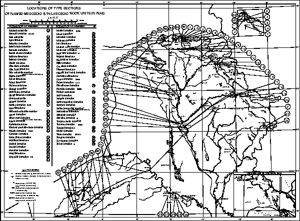
Click on the image to enlarge it.
Plate I.- Locations of type sections of named Mesozoic and Palaeozoic rock units in Iraq.
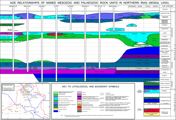
Click on the image to enlarge it.
Plate II.- Age relationships of named Mesozoic and Palaeozoic rock units in Northern Iraq (Mosul Liwa).
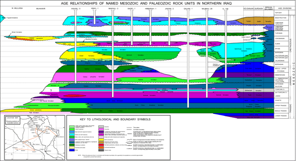
Click on the image to enlarge it.
Plate III.- Age relationships of named Mesozoic and Palaeozoic rock units in Northern Iraq.
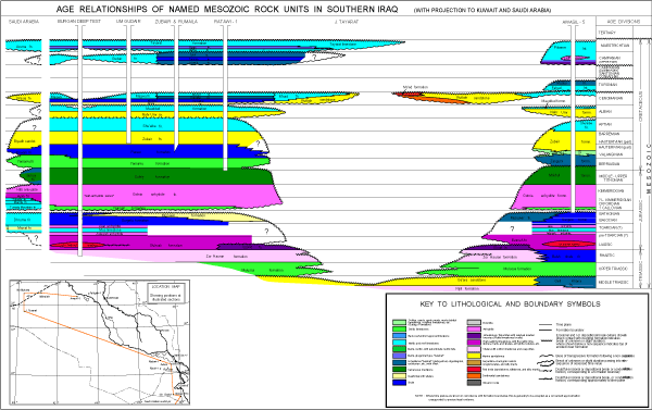
Click on the image to enlarge it.
Plate IV.- Age relationships of named Mesozoic rock units in Southern Iraq (with projection to Kuwait and Saudi Arabia).
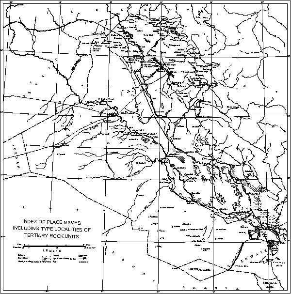
Click on the image to enlarge it.
Plate V.- Index of place names including type localities of Tertiary rock units.
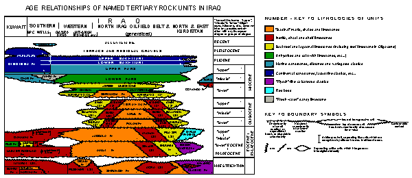
Click on the image to enlarge it.
Plate VI.- Age relationships of named Tertiary rock units in Iraq.
R.C. van, H.V., R. & D.M. (1959).- Iraq.- Lexique Stratigraphique International, Paris, vol. III, Asie, Fascicule 10a.
[Première édition papier (1959) par CNRS ÉDITIONS ; nouvelle édition électronique (2011) préparée par B. , B. & B. sous couvert du Comité Français de Stratigraphie à l'occasion de STRATI2010. Remerciements aux Carnets de Géologie pour leur support à ce projet]
© 1959 Comité Français pour l'Édition du Lexique Stratigraphique International
(Union Internationale des Sciences Géologiques, Commission de Stratigraphie,
Sous-Commission du Lexique Stratigraphique), 2011 Comité Français de
Stratigraphie