Saudi Arabia
(excluding the Arabian Shield)
_
R.W.
(1) Published by permission of Arabian American Oil Company.
References to the geology of Saudi Arabia prior to the start of oil search in 1933 are scarce. Camel trips across the interior escarpment by , during World War I and later years, provided the first concrete evidence that marine rocks are extensively exposed in central Arabia (, 1922, 1928, 1933, 1939). Collections made on these early travels indicated the presence of lower Kimmeridgian (, 1921) and Callovian (, 1933) carbonates. Little else specific was known of the geology of this vast region.
Systematic mapping of the sedimentary geology of Saudi Arabia began in September, 1933, less than four months after the Saudi Arabian Government granted an oil concession to Standard Oil Company of California (2). By 1935, two-man reconnaissance parties had penetrated south as far as Yabrin (lat. 23°15'N, long. 49°00'E), northwest to Hafar al Batin (lat. 28°26'N, long. 45°58'E), west across Ad Dahna to the Precambrian basement.
(2) Standard of California assigned its rights and obligations to a then wholly-owned subsidiary company formed for this purpose, known since 1944 as Arabian American Oil Company (Aramco).
Structure drilling began late in 1936 and seismograph was first used in 1937. By this time the initial objective of getting a general picture of the Concession had been achieved - the succession of geologic strata had largely been worked out, the broad geologic pattern of the area deciphered, the major unconformities recognized, and most of the rock units named.
Dammam Dome, a salt dome, was the first prospect to be tested by deep drilling. Dammam well 1 was spudded on 30 April 1935. Results were disappointing and the well was abandoned after reaching the Middle Cretaceous. Nine more wells were later drilled at Dammam; although some of these were promising none proved out on sustained testing. Thus, the Middle Cretaceous zones, productive at nearby Bahrain Island, had proved a disappointment in ten wells. Dammam well 7 was the first well programmed to test deeper strata. Drilling of well 7, suspended while the Middle Cretaceous was tested, was resumed in late 1937. This well encountered first gas and then large quantities of oil in the Arab Formation (late Upper Jurassic). The first test to yield oil was made on 4 March 1938 and Dammam 7 was completed in the C Member of the Arab Formation later the same month.
Surface mapping, seismograph surveys and structure drilling continued throughout this period, and in 1939, a gravity meter-magnetometer survey was started. War forced a general suspension of operations in 1940 although surface mapping and structure drilling continued on a limited scale. During this period oil was discovered at Abu Hadriya in 1938 and Abqaiq in 1940; unsuccessful wildcats were drilled at Al Alah in 1937, Ma'qala in 1940, and Jauf (al Ju'uf) in 1943-44.
After the war, all exploration activities were resumed at nearly their former level. By the end of 1954, surface mapping parties had surveyed much of the Concession, in part by reconnaissance traverses but mostly in considerable detail. Only limited investigations of special outcrop problems have been carried out since that time.
High-altitude photography was of particular help in this phase. Between 1949 and 1958, 1:60,000-scale photographs of all Aramco's concession and much of the remaining parts of the Arabian Peninsula became available.
By 1959, subsurface exploration parties of one type or another had surveyed more than 1,300,000 square kilometers including the offshore area and, in doing so, had reached the remotest parts of the concession. Exploration activities were reduced accordingly. Full gravimeter-magnetometer coverage had been achieved in 1958 and the shallow-penetration structure drill program was phased out in 1961. Deep stratigraphic drilling was substituted. Wells, 1500 to 3000 meters deep, were spaced uniformly around the margin of the concession and scattered through the interior of the operating area. Information provided by these wells has proved invaluable, bearing heavily on regional correlation, presence and amount of truncation of unconformities, facies changes, and distribution of favorable reservoir rocks.
During the post-war period, wildcat drilling discovered oil at Qatif (Al Qatif) in 1945, at Ain Dar (Ayn Dar) in 1948, and at Haradh (Harad) and Fadhili (Al Fadili) in 1949. Aramco's first offshore discovery came in 1951 with the drilling of the Safaniya (As Saffaniyah) structure in the northwestern Arabian Gulf. Further discoveries in 1951, 1952, and 1953 at 'Uthmaniyah (Al 'Uthmaniyah), Shedgum (Shadqam) and Hawiyah (Al Hawiyah) established Ghawar (Al Ghawar) field, a single anticline - oil-filled from Haradh to Ain Dar and Fazran, a distance of nearly 250 kilometers. Other wells on untested structures and major exploratory wells in known fields followed in quick succession and resulted in important new, or deeper pool, finds at Khursaniyah (Al Khursaniyah) in 1956, Khurais (Khurays) in 1957, Manifa (Manifah) in 1957-1958, Abu Hadriya (Abu Hadriyah) in 1959, Fadhili in 1962, Abu Sa'fah and Qatif in 1963, Berri in 1964, and Ain Dar in 1965.
At the end of 1966, Aramco had discovered productive oil in thirteen fields and sixteen different reservoirs; total estimated remaining proved reserves of recoverable crude oil were nearly 75 billion barrels.
Aramco's exploration effort entered a particularly interesting phase in 1954 when the U.S. Geological Survey and Aramco began work on a series of geologic-geographic maps covering all the concession and most of the Peninsula. The cooperative effort was sponsored jointly by the Kingdom of Saudi Arabia and the U.S. Department of State. The purpose of the program was to make readily available for scientific and economic application the geologic data collected by Aramco and U.S. Geological Survey during the course of their many years' work in the Kingdom.
The cooperative project had resulted by mid-year 1967 in:
- 21 geographical and 21 geological 1:500,000 scale quadrangle maps each covering 3° of longitude by 4° of latitude and in both Arabic and English. [U.S. Geological Survey Miscellaneous Geologic Investigations Maps 1-200 A through 1-220 A (geologic) and 1-200 B through 1-220 B (geographic), 1956-1963.]
- a 1:2,000,000 scale geographic map of the Arabian Peninsula with separate Arabic and English editions. [U.S. Geological Survey Miscellaneous Geologic Investigations Map 1-270 B, 1963.]
- a 1:2,000,000 scale geologic map of the Arabian Peninsula. [U.S. Geological Survey Miscellaneous Geologic Investigations Map 1-270 A, 1963.]
- seven of eleven chapters of a volume on the Geology of the Arabian Peninsula - Geological Survey Professional Paper 560. Published are:
560-B Yemen (F. , 1966)
560-C Aden Protectorate (J.E.G.W. and D. , 1967)
560-D Sedimentary Geology of Saudi Arabia (R.W. , L.F. , C.D. , and E.L. , 1966)
560-E Bahrain (R.P. , 1967)
560-F Kuwait (D.I. , 1967)
560-G Southwestern Iraq (K.M. , 1967)
560-H Eastern Aden Protectorate and Part of Dhufar (Z.R. , 1966).
It is obviously desirable in the naming of rock units to follow generally accepted practices in spite of the fact there is no compulsion to do so in material not intended for publication. Aramco early adopted the rules outlined in 'Classification and Nomenclature of Rock Units' published in the Bulletin of the Geological Society of America, v. 44, p. 423-459, 1933.
Through the years Aramco policy on stratigraphic classification and nomenclature has been modified to accommodate changing concepts and to reflect, where feasible, the recommendations of the American Commission on Stratigraphic Nomenclature (1947-1957). Inline with this policy, the new code on stratigraphic nomenclature by the Commission, which was published in the Bulletin of the American Association of Petroleum Geologists, v. 45, p. 645-665, 1961, has been adopted by Aramco and accepted as basic to current usage.
During the early phases of exploration in Arabia, two sets of rock names were developed; one for the sequence exposed in central Arabia, the other for subsurface sections penetrated in the coastal area. Surface beds, for the most part, were subdivided and named in accordance with the st and ard rules. Subsurface units and names, on the other hand, were often based on some catch lithologic characterization such as 'Dolomitic limestone' or 'Greenish gray shale'. This is to be expected, in that first correlations between two such distant areas would obviously be weak.
As both areas become better known and correlations well established, the unsatisfactory classification and terminology of subsurface units was eliminated and replaced by that applied to surface units for which good names and type localities were available. Obviously the use of surface names in subsurface work, insofar as this is possible, has greatly simplified rock nomenclature for Arabia as a whole.
One situation, which lends itself to nomenclatural difficulties, is the appearance in well sections of sequences of rock which are not represented on the surface owing to nondeposition or elimination by truncation. The Biyadh and Wasia Formations are prime examples (for details refer to discussion of these units). The problem has been solved with varying degrees of success by: (a) extending the limits of subsurface units equivalent to their surface counterparts to include beds to which they are logically related (as was done in the case of the Biyadh Formation) or (b) defining a new unit through correlation with areas adjacent to Arabia, for example, the Shu'aiba Formation.
One interesting aspect of Arabian stratigraphy has been the fact that most Arabian rock units, originally defined solely on the basis of the criteria for rock-stratigraphic units, have proved over the years to approximate time-stratigraphic units as well. This is the case both along the length of outcrop and in the subsurface. Facies changes do occur but these usually are gradual and unit boundaries can often be traced over much or all of the concession area. The result has been to greatly reduce the number of units and names necessary to subdivide and classify the Arabian stratigraphic column.
In the past no little confusion has been caused by failure to discriminate between rock-stratigraphic terms and reservoir terms and a tendency to use the two interchangeably. Reservoir boundaries may or may not coincide exactly with stratigraphic boundaries; indeed, in Arabia they usually do not, except locally. As a consequence, reservoir units are established independent of rock-stratigraphic units.
According to Aramco practice, a reservoir is an interval of rock which is distinguished by its potential ability to act as a discrete container for hydrocarbons, and does somewhere in Arabia contain commercial hydrocarbons. The upper and lower limits of a reservoir in a particular well are established regardless of the fluid content of the reservoir in that well. The top and base of the reservoir are placed respectively at the uppermost and lowermost development of porosity and permeability.
It has happened coincidently that most of the presently recognized reservoirs are confined to a single rock-stratigraphic unit. As a result, it has been possible to reduce the number of proper names in the Aramco stratigraphic system by using the same name for a member or formation and its associated reservoir.
An important function of the field parties throughout the many years of exploration, has been to gather place names. Aramco's Arabian Affairs Division of the Government Relations Organization has played a major role in evaluation of the data collected and in the selection and proper placement of names used in various maps and reports. Saudi Arabs from all parts of the Kingdom were consulted by Aramco's Arabists to assure accuracy of transliteration and to evaluate old names and obtain new ones. All names were reviewed by the Board of Geographic Names in Washington, D.C. for conformance with the BGN/PCGN System of transliteration.
To assist the unfamiliar reader, a gazetteer of Arabian place names used in this volume is included in the appendix. The coordinates listed refer to specific geographic points or the approximate centers of regional features.
It is apparent that a report of this type is basically a compilation of data collected and ideas formulated by the numerous geologists who, over the past 34 years, have worked in Saudi Arabia. The results of their work reposes largely in unpublished company reports; reports which provided most of the information on which this account is based. Were appropriate, individual geologists have been cited; however, many others, whose contributions were of equal importance, must of necessity remain anonymous.
Two Aramco geologists - Max (*) and R.A. (**) - should be singled out for special mention. Both were pioneers in the study of the geology of Saudi Arabia. arrived in the field September 20, 1934, almost one year to the day after oil exploration had commenced. arrived in mid-September of 1936. Much of the work on which this report is based was either done by them personally or under their guidance, for and were Aramco's chief geologists respectively from 1936 to 1947 and 1947 to 1958. Both men were true scientists and outstanding geologists and it was during their tenure that the framework of the stratigraphy and structural geology of Arabia evolved in much its present form. A large amount of new work, much of it detailed, has done little to modify their basic concepts; indeed, such data have usually served to strengthen their predictions.
(*) Deceased, April 16, 1952.
(**) Deceased, September 1, 1958.
The foundation for sedimentary deposition in Saudi Arabia can readily be generalized into two positive structural elements - on the west, the western Arabian shield, a vast dominantly Precambrian complex of igneous and metamorphic rocks; on the south, the Arabian portion of a crystalline massif extending northeast from the horn of Africa.
Since Precambrian time the massifs have been stable, subject only to gentle, epeirogenic movement. On these rigid, peneplaned landmasses were deposited a thick sequence of continental and shallow-water shelf sediments dipping gently into the Mediterranean, Arabian Gulf and Rub' al-Khali basins.
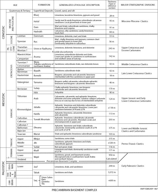
Aramco geologists have identified and mapped in considerable detail an
aggregate total of nearly 5500 meters (18,000 feet) of sedimentary section ranging in age from presumed Cambrian to ?Pliocene
(Table I ![]() ). The main rock units have been blocked out and their limits have been tested widely enough to assume that they will stand in essentially their present form. As always,
much work remains to be done - particularly so far as paleogeography, regional
lithofacies, and more precise dating of some parts of the section are concerned.
It is expected, however, that additional work will affect only the detail and the major
framework as now defined will survive.
). The main rock units have been blocked out and their limits have been tested widely enough to assume that they will stand in essentially their present form. As always,
much work remains to be done - particularly so far as paleogeography, regional
lithofacies, and more precise dating of some parts of the section are concerned.
It is expected, however, that additional work will affect only the detail and the major
framework as now defined will survive.
The sedimentary section exposed in Saudi Arabia falls naturally into eight major divisions. Dominated by a characteristic lithology and separated by significant unconformities, the divisions are:
- Lower Paleozoic clastic rocks - ? Cambrian through Lower Devonian; dominantly coarse clastics but with some thin carbonate beds in uppermost part.
- Permian and Triassic clastic rocks - Upper Permian through Upper Triassic; alternating nonmarine-marine units, dominantly clastic but with thick calcareous intervals at base and in middle.
- Lower and Middle Jurassic clastic and carbonate rocks - Toarcian to ?Callovian; in central Arabia marine shale interbedded with carbonate, grades to sandstone in northern and southern areas of outcrop.
- Upper Jurassic and early Lower Cretaceous carbonate rocks - Callovian through Valanginian; mostly carbonate but with alternating evaporite-normal marine cycles near end of Jurassic.
- Late Lower Cretaceous clastic rocks - Hauterivian through Aptian; dominantly coarse clastics with thin basal carbonate unit.
- Middle Cretaceous clastic rocks - Cenomanian to ?Turonian; dominantly coarse clastics.
- Upper Cretaceous and Eocene carbonate rocks - Campanian through Lutetian; carbonate units but in subsurface lower Eocene includes evaporite interval.
- Miocene and Pliocene clastic rocks - dominantly sandy limestone and sandstone.
Though facies changes often alter the character of their contained rocks, these eight major stratigraphic divisions are recognizable in subsurface sections as well.
In northwestern Saudi Arabia at least 1900 meters of Lower Devonian and older Paleozoic rocks are exposed. Exposures extend southeast from the Jordan border, form a gently curving arc parallel to the northern margin of the shield, and disappear eastward under the blanket sands of An Nafud.
Silicate clastics dominate the entire succession. The lower one-third (Saq Formation and equivalent units) is almost exclusively white, buff, and red, medium- to coarse-grained, cross-bedded sandstone. The Tabuk Formation, a thick section of graptolite-bearing shale alternating with light-colored, micaceous, commonly cross-bedded sandstone follows. Capping the sequence is the Jauf Formation nearly 300 meters of shale with subordinate stringers of sandstone and carbonate.
Intervals within this sequence have been dated by graptolites and brachiopods as Lower Ordovician (Arenig), Silurian, and Lower Devonian. Cambrian fossils have not been found although recent work shows the lower part of the Saq Formation to be equivalent to Jordanian units of certain Cambrian age.
Data on Middle East Cambrian to Devonian rocks are too incomplete to furnish any satisfactory picture of the paleogeography of those times. The problem is further complicated by the fact that occurrences of these Systems are largely inadequately dated and equivalencies are usually uncertain.
Rocks of proved or presumed Cambrian age occur only sparsely in areas immediately adjacent to Saudi Arabia. Cambrian strata have been described from southwestern Jordan where they are exposed in a thin belt bordering the Dead Sea rift. Much of this section is sandstone and gravel although, opposite the Dead Sea, it includes a thin shale-carbonate unit with Middle Cambrian trilobites. Almost certainly, the Jordan sequence is a continuation of the chiefly continental, but also in part littoral, sandstone exposed in Saudi Arabia.
North of Al Huqf, in the featureless Oman desert, are several salt domes with salt of presumed Cambrian age. These domes expose a varied assortment of rock types, including some igneous debris, which suggest correlation with the Middle and Upper Cambrian Hormuz Series of southern Iran-Arabian Gulf-Trucial Coast salt domes.
Cambrian rocks are widely known in southwestern Iran; many of the occurrences are associated with intrusive salt masses. The salt intrusions and related rocks of the Hormuz Series contain fragments ranging in age from Lower Cambrian to Jurassic. Cambrian rocks have also been found in normal outcrop along the northeastern margin of the Zagros Mountains as well as within the area of salt plugs. Red shale and sandstone accompanied by subsidiary gypsum and traces of salt represent the Lower and Middle Cambrian in the northeast and mainly salt prevails in the south. In both areas, Upper Cambrian is red and green shale and sandstone with thin limestone and dolomite beds.
Roughly, the area of Cambrian salt is southwest Iran, islands of the Arabian Gulf north of the Trucial Coast, the Trucial Coast, and southern Oman. A possible outlier is found in Jabal Sanam in southern Iraq where rocks of Hormuz type are associated with a strong negative gravity anomaly. In Saudi Arabia itself, one structural feature, Dammam Dome, offers strong evidence of salt piercement origin. Other features, although salt movement may have been involved in their formation, do not show sufficiently clear evidences of this origin to use them to outline the extent of underlying salt.
Outcrop sections in central Arabia are of little aid in outlining the original extent of the saline basin. As the dated portion of the Paleozoic is Ordovician to Lower Devonian and no slumping has been reported below this level, it seems likely that saline deposits were not originally present. Thus, it is probable that the limit of the area underlain by salt lies between Dammam Dome and the Paleozoic rocks exposed in the interior, the latter probably representing a marginal nonmarine and littoral clastics facies bordering the evaporite basin.
About 400 meters of sandstone and shale comprising the upper part of the Saq and the lower part of the Tabuk Formations have been assigned to the Ordovician System in Saudi Arabia. The Arabian sequence extends without significant lithologic change into southern Jordan.
Nearly identical sandstone and shale containing Cruziana constitute the reported Ordovician lithologic units exposed in northern Iraq and Oman. In addition, one well in Oman near Wadi al Ghabah (lat. 21°20'N, long. 57°19'E) drilled about 2000 meters of Lower Ordovician clastics containing graptolites and Cruziana.
Described Ordovician lithologic units certainly reflect extensive shallow-water conditions in which several marine transgressions are recorded by graptolite-bearing shales, trilobites reported from Jordan, and occurrences of Orthoceras sp. in Saudi Arabia and Iraq. Non-fossiliferous, cross-bedded sandstone and other massive sands with abundant pelecypod molds record intermittent emergence and near-shore conditions.
Graptolites and brachiopods attest to the marine nature of some of the Silurian and Devonian rocks in Arabia; other parts are certainly continental and transitional. Except for Jordan, equivalent or partially equivalent rocks are unknown. Even in southwestern Iran, middle Paleozoic time is poorly represented by sediments, although Monograptus, a genus usually considered to be Silurian, has been reported.
Nearly 1000 meters of Permian and Triassic sedimentary rocks are exposed in a wide belt that curves around the eastern margin of the Arabian shield. The sequence falls naturally into four subequal units which apparently represent alternating marine and nonmarine deposition. At the base is the Khuff Formation in which limestone and dolomite alternate with red and green gypsiferous shale. Next above is the Sudair Formation, unfossiliferous brick-red and green shale, presumably nonmarine. The Jilh Formation, a thick section of limestone interbedded with light-colored sand and some gypsiferous shale follows. At the top are highly colored clastic beds with petrified wood as the only recognizable organic constituent; characteristics that suggest the unit, the Minjur Sandstone, is mainly continental. As a whole, the Permian and Triassic appear to be mixed marine and continental clastics, the latter predominating.
Only the sketchiest time framework has been supplied to the outcrop by marine fossils. The Khuff Formation contains molluscs which have been assigned a probable Late Permian age. Higher carbonate stringers contain fragments of ammonites considered to be Middle Triassic. Fortunately, nearby bore holes have yielded rich suites of diagnostic spore and pollen from equivalent beds. On the basis of these, it is safe to say that the outcrop contains an almost complete Upper Permian through Upper Triassic (Keuper) sequence.
It is within the Permian and Triassic Periods that dues to the outline of the major Mesozoic (Tethys) basin to the north and east of the Arabian massif begin to emerge. Roughly, the center of the Tethys trough (marked by maximum subsidence-thickest sedimentation, and deeper-water deposition) forms a great arc around the Arabian Shield. It passes east through Lebanon, Syria and Turkey; southeast across Iraq; then, in southwestern Iran, parallels the modern Arabian Gulf trend. Older Paleozoic rocks may also have been deposited, possibly in considerable thicknesses, in an ancestral basin of similar position and configuration, although evidence for their deposition is now lacking.
Late Permian time marks a significant change in sedimentation from dominantly clastic to mostly carbonate. During this epoch, the sea spread over much of the Arabian foreland and there deposited a sheet of shallow-water limestone (Khuff Formation) extending from northern Iraq and Turkey to Oman. In each area, the relationship to underlying units is unconformable and the transgression initiates a period of gradual subsidence which continued with but periodic interruptions into the Cenozoic.
Dolomite, replacing shallow-water clastic limestone, dominates many of the Upper Permian well sections of central and coastal Arabia, the central Rub' al-Khali and also occurs in significant amounts in sections exposed in the mountains of Oman. Included evaporite deposits in northern Iraq and Saudi Arabia attest to the periodic existence of 'barred basin' conditions.
In the outcrops of Arabia, rocks of continental and near-shore facies dominate the Triassic, although at least one more or less persistent marine transgression is recorded by Middle Triassic limestone.
Marginal clastic deposits also prevail in Jordan where Triassic rocks crop out near the Dead Sea, although, here also, thin limestone and evaporite beds occur sporadically through the section. The Jordanian and Arabian exposures almost certainly block out in rough form the southwestern and western edges of the Triassic sea.
It now seems safe with recent palynological correlations to extend Triassic units from outcrop into the coastal and Rub' al-Khali areas of Arabia. Similarities in lithology and stratigraphic relations offer strong support for this usage. Some reservations should be held on the age of sediments just below the pre-Jurassic unconformity because it is not certain that beds equivalent to the Upper Triassic Minjur Formation on outcrop are fully represented to the east. In fact, there is some evidence that Minjur rocks are entirely removed at least over the southern half of the Rub' al-Khali basin and much of the coastal province as well.
In all coastal and Rub' al-Khali wells so far drilled, the lithologic composition of the Triassic is dolomite complexly inter-bedded with anhydrite, limestone, shale and some sandstone. Similar conditions must have persisted over much of the Arabian foreland for, even though details of the sequence vary, like rocks are found in the mountains of Oman, southwestern Iran and northern Iraq. Wells drilled intermediate between the Arabian coast and the outcrop belt penetrated the same complex of rock types although shale predominates in the south, and anhydrite, in the north.
There is little doubt that the limestone, now abundantly dolomitized, is of shallow-water origin. Original clastic textures are commonly preserved even though dolomite replacement is complete. The common occurrence of thin evaporite units throughout, as well as fetid dolomite and dark shale, attests to the fact that restricted conditions prevailed or constantly threatened. It is believed that throughout the period the basin of deposition occupied a relatively constant area with sills cutting communication from time to time between certain parts.
So far as known, the passage from Triassic to Jurassic is everywhere represented either by unconformity or nonmarine sedimentation.
Lower Liassic marine strata have been reported in Iraq, Kuwait, southwestern Iran, and Oman, however, it is with the Toarcian that widespread Jurassic transgression begins. The position of marine Toarcian rocks indicates that an expanded Tethyan sea covered the northern tip of Sinai, northwestern Jordan, Lebanon, much of northern Syria and eastern Iraq, eastern Arabia (as far south as lat. 22° N) and extended eastward into Iran and across northern Oman.
Bajocian-Bathonian time witnesses further expansion of the Tethys sea. This expansion is particularly evident in southern Arabia where the basal contact of the Middle Jurassic and succeeding Upper Jurassic carbonate units is markedly transgressive.
The Lower and Middle Jurassic (Marrat and Dhruma Formations respectively) are typically represented in central Arabia by about 500 meters of shallow-water shale and carbonate. In the Riyadh-Durma area, a thin, basal, unfossiliferous sandstone is followed by alternating limestone and shale - all highly fossiliferous. The lowermost carbonate bears Toarcian ammonites (uppermost Lower Jurassic) and above it, definite Bajocian and Bathonian and possible Callovian beds have been identified.
Lithologic changes to the south along outcrop consist primarily of gradual replacement of shale and carbonate by sandstone. The transition first takes place in the lower beds and progressively affects higher units so that at latitude 21° N only sandstone, apparently continental, makes up the entire sequence. Hints of a similar approach toward strand line conditions can be seen in the northernmost exposures near Az Zilfi (lat. 26°18'N).
The Marrat Formation maintains its identity in well sections in the Rub' al-Khali and Eastern Province where it is mainly limestone but partly sandstone and shale. Equivalent beds in Kuwait and Iraq contain significant amounts of anhydrite. Included limestone, commonly finely fragmental and oolitic, attests to the neritic and lagoonal conditions in which Toarcian deposition took place.
Two facies of the Middle Jurassic (Dhruma Formation) are recognizable in the coastal area of Saudi Arabia. From Abu Hadriya south, aphanitic limestone, sometimes dark and argillaceous, dominates. Variable proportions of lime sand usually with lime-mud matrix are interbedded. Northward, at Jauf and Safaniya, darker, more argillaceous, presumably deeper-water, limestone and gray-black shale occur. In this area, few lime-sand beds are present and these beds are admixed with dark impure mud matrix. These basinal, argillaceous limestones and gray-black shales can be traced north into northeastern Iraq and across the Arabian Gulf into southwest Iran.
Updip, the darker sediments rapidly give way to lighter colored, commonly coarsely clastic, clean-washed, shelf limestone. This neritic facies has been recognized in northwestern Jordan, central Iraq, probably passes under the Saudi Arabia-Iraq Neutral Zone, includes Khurais, extends south into the western Rub' al-Khali and then swings east across the mountains of Oman.
Middle Jurassic units are continental clastics in southwestern Arabia, Yemen and the Aden Protectorates. Wells along the southern margin of the Rub' al-Khali show Upper Jurassic directly on Permian or older strata. Presumably, Lower and Middle Jurassic rocks in marginal facies wedge out a short distance north.
The transition from Middle to Upper Jurassic, long considered unconformable, now appears to take place without interruption or at the most involves only slight disconformity. Misleading was the fact that basal Upper Jurassic rocks do indeed rest with definite discordance on older units around the southern margin of the Rub' al-Khali basin. Now, however, good faunal control shows that uppermost Middle Jurassic beds are laterally persistent and without evidence of truncation. Rather than elimination at the top by erosion, it seems more likely that the Middle Jurassic pinches out to the south by progressive onlap and loss of successively younger beds at the base.
Upper Jurassic and early Lower Cretaceous rocks, almost entirely in shallow-water limestone facies, are spectacularly exposed in central Arabia where they stand up as a series of scarps subparallel to the eastern edge of the shield, More than 850 meters of section has been measured near the latitude of Riyadh. Calcarenitic limestone (lime sand admixed with lime-mud matrix) predominates, although thick, often laterally persistent beds of calcarenite (clean-washed lime sand and gravel) are common at many levels. Lime-sand grains are of various origins but skeletal debris and aggregate pellets are most common.
The basal 200 meters of Upper Jurassic section, composed of abundantly coralliferous and stromatoporoidal, lithographic limestone is a massive cliff former. This unit - the Tuwaiq Mountain Limestone - stands up in sharp relief for more than 1000 kilometers to form the dominant scarp of Jabal Tuwayq, one of the major topographic features of the Arabian Peninsula. Exposed at the base of the cliff-forming unit is a zone rich in fossils considered to be middle Callovian. Strata representing remaining Upper Jurassic stages and the early Lower Cretaceous through Valanginian are deposited above without apparent interruption. The only significant change in depositional environment throughout is reflected by the exposure of massive Kimmeridgian-Tithonian anhydrite in a solution sink, Dahl Hit (lat. 24°29'18'N, long. 47°00'06"E). Laterally, little is known of the true evaporite rock sequence owing to extensive removal by solution. Mostly, the area in which these beds would be expected to crop out is a nearly hopeless jumble of low hills representing complexly settled rocks. Equivalent rocks are extensively known in the subsurface where they comprise the Hith-Arab evaporite-carbonate complex.
Upper Jurassic-early Lower Cretaceous rocks, dominantly in shallow-water carbonate facies, are extensively exposed in the Middle East. The succession cropping out in central Arabia is only a small part of a great belt of limestone that extends from north Africa across northern Sinai and Lebanon, covers large parts of Syria, Iraq, Iran, Oman, Yemen, and the Aden Protectorates, and continues into East Africa.
The episode of subsidence, expansion, and infilling of the Tethys trough that began in the Early Jurassic continued without apparent interruption into the Late Jurassic. Low-relief landmasses adjacent to the shelf contributed almost no terrestrial debris. Lime sand, derived from local sources, served as a hydraulic substitute for quartz grains and, as a result, calcarenite was concentrated along the beach, piled up to form offshore bars, and spread out in sheets over bottom-high parts of the Arabian foreland. Lime mud, substituting for clay particles, came to rest in sheltered areas or below effective wave and there formed tight, aphanitic limestone or the matrix of calcarenitic carbonate rock.
During Callovian to early Kimmeridgian time, the Tethys was a broad shallow sea depositing clastic-textured limestone from central Arabia east to Iran and Oman and south across Yemen and the Aden Protectorates. Similar neritic limestone extends north through central Iraq. In these areas extensive calcarenite development and abundant remains of shallow-water organisms attest to the fact that shoaling of the sea floor was widespread and persistent.
Perhaps the most significant facies change within the Upper Jurassic-early Lower Cretaceous sequence occurs in central Iraq, where the upper part of the ?Callovian is represented by massive anhydrite. This change is of particular importance for it marks the beginning of evaporite conditions that were eventually to spread over much of the basin of deposition. It is assumed that conditions essential to the precipitation of calcium sulphate - restricted basin where evaporation exceeds precipitation and runoff- obtained first over central Iraq and then spread progressively south to include Kuwait. Here, massive salt is interbedded with subordinate amounts of anhydrite. Deposition of evaporite in Saudi Arabia did not begin until near the end of early Kïmmeridgian time.
With the approach of evaporite conditions, the Tethys shoaled and widespread deposition of calcarenite began. In addition to covering much of Saudi Arabia, calcarenite deposited at this time has also been recognized in southwest Iran, Qatar, and Oman. Essentially equivalent current-washed deposits may occur elsewhere (for example Yemen and the Aden Protectorates) but available descriptions are too vague to be certain. The clastic limestone (Arab-D reservoir) represents the transition from continuous carbonate deposition to precipitation of nearly pure anhydrite. It also initiated widespread cyclic sedimentation which resulted in four main cycles, each starting at the base with normal marine limestone and closing with an evaporite unit. Recognized in most wells so far drilled in Arabia and also present at Qatar and Bahrain, each anhydrite may represent separate expansions along a similar route from the north where a more-or-less permanent evaporite basin persisted.
At one time or another, the evaporite basin extended at least as far east as southwest Iran. Presumably one or more of the incursions reached Oman where a limestone breccia-conglomerate occupies an equivalent stratigraphic interval. Major exposures of Upper Jurassic gypsum-anhydrite in northeastern Yemen and adjacent parts of the Aden Protectorates show that an arm of the saline basin (s) extended southwest into this area as well.
In Saudi Arabia and Qatar, carbonate members introducing the four evaporite cycles are of prime importance because of their oil content. The lowest of these - the Arab-D reservoir - is by far the most important; it contains productive oil in nine widely scattered fields.
Owing to intense interest prompted by oil search enough data are now available to reconstruct, on a regional scale, conditions associated with the deposition of the Arab-D limestone. The general picture to emerge is that of sedimentation on a broad shelf. On the west, near the present area of Upper Jurassic outcrop, mainly clean-washed calcarenite and calcirudite accumulated. Presumably these mud-free deposits record littoral and near-littoral deposition around the edges of a carbonate-covered platform. Presence of a wide belt of generally finer calcareous sediment immediately to the east suggests lagoonal conditions. The lagoonal sediments are in turn flanked on the east by a relatively unbroken sheet of clean calcarenite that blankets northern Ghawar-southern Abqaiq and extends north probably as far as Manifa. These lime sands are interpreted as representing an offshore bar, or more likely, a group of offshore bars.
Carbonate deposition closed earlier in the west where precipitation of anhydrite first began. Saline conditions moved progressively east and eventually terminated carbonate sedimentation over most of the Arabian Gulf area. The same general carbonate-evaporite cycle was to be repeated at least three more times before the close of the Jurassic and open marine conditions again prevailed.
With the influx of fresher water and termination of anhydrite deposition, shallow-water, clastic-textured limestones were once again deposited - limestones which are generally indistinguishable from those laid down during the Late Jurassic. These early Lower Cretaceous rocks maintain a high degree of uniformity overmuch of the foreland area. Particularly noteworthy is the lateral extent of some of the calcarenite units which must have been deposited literally as great sheets of lime sand. One such Berriasian lime sand within the Sulaiy Formation can be traced from Khurais to the Arabian Gulf and from the southern end of Ghawar into Kuwait and Iraq. Even though continuity over the entire area is not proved, concentration of sand on this scale must assuredly reflect an extensive, remarkably flat, submarine platform only just below sea level. Although calcarenite is the most striking lithology, the larger part of the Berriasian-Valanginian (= Sulaiy and Yamama Formations) section is aphanitic limestone and calcarenitic limestone.
Similar neritic carbonates occur in the central Rub' al-Khali, Qatar, Oman, coastal Iran, Kuwait, and central Iraq. More basinal calcareous mudstone and radiolarian shale, marl and limestone cover eastern Iraq. Presumably these indicate approach to the deeper part of the basin. The axis of the Tethyan trough at this time apparently fell near the northeast border of Iraq and extended southeast into Iran along the Zagros Mountains.
Early Lower Cretaceous rocks do not occur along the southern margin of the Arabian Peninsula. The limitation may, however, be the result of truncation rather than nondeposition. Berriasian and Valanginian rocks are, for all practical purposes, eliminated south of latitude 20° N by pre-Hauterivian (pre-Buwaib) erosion. What is probably an equivalent and still active surface of unconformity is recognizable far to the south in the Hadramaut.
Except for a thin, albeit persistent basal limestone (Buwaib Formation), late Lower Cretaceous rocks in central Arabia are mainly continental sandstone (Biyadh Formation). The characteristic lithology of the basal carbonate, which is nowhere thicker than 20 meters, is calcarenite and calcarenitic limestone, the sand- and gravel-size grains mostly being molluscan debris. Fine-grained sandstone is interbedded with carbonate in the upper part and the unit shows gradational contact with the overlying continental series.
Late Lower Cretaceous rocks show rather marked paleogeographic differentiation. The basal limestone, so persistent on outcrop, gives way to shale only a short distance down dip, and this facies prevails over much of the coastal area. Deposition of the Buwaib carbonate-shale sequence was followed by widespread emergence. Continental and transitional continental-marine conditions obtained in the west over a belt nearly 200-300 kilometers wide and extending from Yemen to northern Iraq.
The eastern boundary of the area where sandstone is dominant follows approximately the Tigris River north of Baghdad, passes close to Basra, just east of Kuwait, west of Safaniya and Abu Hadriya, across northern Ghawar, and thence trends south toward Al Mukalla on the Arabian Sea. To the east, across Oman and the Arabian Gulf, neritic, and possibly some deeper-water, limestone dominates.
Radiolarian marl, shale and limestone occurs along the eastern border of Iraq and suggest basinal conditions prevailed in the area. Other radiolarian limestones of this age are known in northern Oman.
Widespread emergence of the Arabian interior during Barremian, Aptian and Albian time was followed by rapid and far-reaching Cenomanian Wasia Formation) transgression. Northern Arabia was particularly active in this respect.
Marked subsidence and oscillation of the shoreline led to deposition of thin marine stringers far up on the foreland. Greatest subsidence occurred from the latitude of Riyadh northward bringing Cenomanian and ?Turonian sediments across the beveled edges of progressively older units to eventually cap Lower Devonian strata in the vicinity of Sakakah. During this submergence, littoral and shelf sand, with rare thin carbonate inter-tongues, was spread over the northern area of Arabian outcrop; coarse clastics of probable marine origin continued down dip far enough to blanket Ma'qala and Khurais and extended across the southern tip of Jordan and the southwest border of Iraq.
South of Riyadh, the marine sand grades laterally into continental deposits, still mainly sandstone.
East of the nonmarine and near-shore clastics, progressively more lagoonal and neritic sediments are introduced at the expense of the sandstone. Shale is the main rock type over a large area including the Rub' al-Khali, and much of central and north-eastern Arabia. Similar pelitic rocks probably extended into southwestern Iraq and southern Jordan. Further basinward, neritic limestone, in part in rudist reef facies and commonly Orbitolina-bearing, becomes dominant. Such shelf carbonates were deposited in a broad belt extending from southern Arabia to Jordan. More precisely, subsidence during Cenomanian and ?Turonian time permitted accumulation of shallow-water carbonate deposits over southern Arabia generally east of the 49th Meridian and south of the Rub' al-Khali. The limestone belt continues north across the mountains of Oman, flares out to cover the Trucial Coast, Qatar, Arabian Gulf, and southwestern Iran and then swings inland to include Kuwait, southwestern Iraq and most of Jordan. Deeper water globigerinal marls were being deposited at the same time in northeastern and eastern Iraq. Presumably these continue in to Iran but proof of this is lacking.
Middle Cretaceous rocks, older than those rocks exposed on outcrop, are present in the subsurface. In coastal Arabia and the western part of the Rub' al-Khali, units of Albian age comprise a thick widespread complex of deltaic, littoral and other shallow-water deposits. Similar complexes of sandstone and shale occur in southern Iraq, Kuwait, Bahrain and Qatar. Northward and eastward the sand-shale facies grades laterally into a shale-limestone sequence.
Upper Cretaceous and Eocene rocks, widely exposed in Saudi Arabia, are, for the most part, limestone and dolomite with a few very thin interbeds of marl and shale.
When viewed only in terms of Saudi Arabia, Upper Cretaceous (Aruma Formation) paleogeography is relatively simple. Dominantly shallow-water carbonates blanket the area of outcrop and deeper water shale and limestone come in as distance from the basin margin increases. Placed in the framework of adjacent areas, the picture becomes significantly more variable.
Emergence, possibly beginning in the Turonian, affected mainly the shoreward parts of the basin and isolated interior structures. Renewed transgression began in the Campanian and reached a maximum during Maestrichtian time. Marginal areas of the basin are defined by sandstones in southwestern Arabia, the Aden Protectorates, and Yemen. Presumably those sandstones in Yemen are exclusively continental, passing east and northeast through deltaic and shallow-water facies. Similar sandstones occur in northwestern Arabia near Sakakah and in southern Jordan.
Along the southern fringes of the Rub' al-Khali shale is the major lithologic component of the Aruma Formation almost to the exclusion of all other rock types. Shale persists into the central Rub' al-Khali and coastal Arabia, but is there confined mainly to the lower part of the Upper Cretaceous. The upper part (Campanian-Maestrichtian) is dominantly shallow-water limestone of the blanket type. Locally, rudistids as well as other heavy-shelled molluscs are abundant. The limestone sheet covers the central Rub' al-Khali, northern outcrop area, coastal Arabia and Qatar, Kuwait, southwestern Iraq, and Jordan. In northeastern Iraq, and presumably southwestern Iran as well, more basinal conditions are reflected by the deposition of a thick succession of globigerinal marls.
Tectonic development during upper Late Cretaceous time also played a significant role in basin architecture and sediment patterns. Major uplift, generally along the northeastern side of the Zagros Mountains, contributed volumes of flysch-like detritus to a long, linear trough rapidly developing on the southwest. Flysch-type sediments continued to pour in and gradually displaced the area of globigerinal marl sedimentation to the southwest.
In the Oman Mountains, deposition of a thick radiolarite-chert series was followed by large scale extrusions of ophiolite. Orogenic movements initiating the formation of the now complex Oman geanticline, began during this time. Concurrently, volcanic activity apparently commenced in Yemen and the Western Aden Protectorate.
Definite disconformity between Cretaceous and Paleocene can be demonstrated in several areas adjacent to Saudi Arabia. Work with planktonic foraminifera suggests equivalent hiatus in Arabia as well, although this has not been definitely proved. In any event, Paleocene and lower Eocene transgression was widespread and resulted in a thick succession of neritic limestone and more basinal marls (Umm er Radhuma Formation). Marginal sandstones of this epoch are unknown; carbonates alone being exposed along the landward edges of outcrop. Abundantly fossiliferous limestone documents Paleocene and lower Eocene submergence of the southern half of the Arabian Peninsula generally east of longitude 47° E. One exception to this is the mountains of Oman where Paleocene-Eocene limestone overlaps both flanks of the range but does not reach the crest. Al Huqf itself was also incompletely covered although the remainder of the Oman-Dhufar foreland apparently was submerged.
North of latitude 24° N, the belt of carbonate, extending from Arabian outcrop to southwest Iran, swings northwest and continues on into Iraq. Most of Iraq was covered by globigerinal marl except near the northeast border. Here, flysch-type deposits accumulated in considerable thickness in a trough slightly offset southwest relative to the Late Cretaceous foredeep. Paleocene carbonates also covered much of Jordan.
The Ypresian Age of the early Eocene witnessed the introduction of persistent and widespread evaporite precipitation (Rus Formation). Anhydrite in considerable thickness was deposited over the Eastern Aden Protectorate and Dhufar, in the Rub' al-Khali basin, across Qatar, the western Arabian Gulf, and northeastern Arabia, and continued into Kuwait and southern Iraq. Normal marine conditions prevailed in nearby areas except for red-bed deposition along the northeastern flank of the still subsiding Iraq-Iran trough.
Invasion of fresher sea water in the middle Eocene again brought about widespread deposition of carbonates, both nummulitic (Dammam Formation) and globigerinal. For the most part, pre-anhydrite sedimentation patterns and overall distribution of carbonate were reestablished. In northeastern Iraq, however, clastic deposition ceased, and a carbonate-depositing sea once again covered the area.
Widespread emergence of the Arabian platform in the middle Eocene reduced the Tethys to a relic sea, probably much as it is now. Since then emergence has persisted and continental conditions have obtained over Saudi Arabia with the exception of minor intermittent flooding of the present coastal area in middle Miocene (Dam Formation) time.
In northeastern Arabia, the stratigraphic sequence above the Eocene consists of a relatively thin succession (200-300 meters) of Miocene and Pliocene rocks, mostly of nonmarine origin. These deposits - a heterogeneous assemblage of sandy limestone, calcareous sandstone, sandy clay, and sandstone - blanket the Eastern Province. Much of the section contains only occasional fresh-water fossils and these are of no use in dating. In limited parts of the coastal area, however, marine molluscs and echinoids have been found through the middle part of the sequence. The fauna indicates approximate correlation with Lower Fars of Iraq, Kuwait and Iran and is presumably middle Miocene. A lithologically similar, although much thicker, Miocene and ?Pliocene sequence covers the Rub' al-Khali.
It is presumed that the Miocene sequence in Arabia represents in effect a thin wedge of lacustrine, fluvial and coastal plain deposits peripheral to the main area of subsidence in Iran and Iraq where evaporite-forming conditions prevailed.
Marine sedimentation persisted in Iraq and Iran for a brief period following the Lower Fars evaporitic phase but this was brought to a close with the start of large-scale deformation northeast of the main trough. Rising mountain folds shed great volumes of clastic debris into adjacent synclines; first red-beds (Upper Fars) and then, with accelerated deformation, coarse sand and conglomerate (Bakhtiari). Combined thickness of these two units in some places reached as much as 4,000 meters.
In spite of the intensity of diastrophism on the other side of the Arabian Gulf, little trace of tectonic activity has been found in Arabia. In fact, rocks of presumed Pliocene age have a low average dip of 1 to 2 meters per kilometer toward the Arabian Gulf. How much of this is the result of tilting and how much is to be regarded as initial dip is unknown. Vast lava fields in the shield areas and in northwestern Arabia do attest, however, to considerable volcanic activity at this and later times.
Click on the image to enlarge it.
Table I. Saudi Arabian outcrop sequence.
Click on the image to enlarge it.
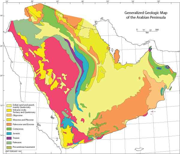
Plate I. Generalized geologic map of the Arabian peninsula.
The structural pattern of the Arabian Peninsula was set in Precambrian time with stabilization of the Arabian shield. These ancient rocks, now lying in tangled confusion, in themselves reveal a complex and mobile history. By the outset of the Paleozoic Era, however, they had been fused into a rigid land mass and their surface reduced to a nearly level plain.
From the Cambrian on, vast epicontinental seas moved back and forth across the lower parts of this stable basement core and there deposited a comparatively thin succession of nearly flat-lying strata. The epicontinental seas were, in turn, flanked on the north and east by a great sedimentary basin - the Tethyan trough - that occupied a relatively constant area in Turkey, northern Iraq, and southwestern Iran. The trough remained a negative feature throughout most of the Paleozoic and Mesozoic while many thousands of feet of sediment accumulated. Destruction of the ancient seaway began in Late Cretaceous with orogenic movement recorded from Turkey to Oman. The climax came, however, in the late Tertiary (Alpine orogeny) when rocks from the deeper part of the basin were folded and thrust to form the Taurus-Zagros-Oman chain of mountains.
Within this broad tectonic framework, two major structural provinces are recognized. One is the comparatively stable interior region whose rigidity is controlled by Precambrian basement. The exposed part of the shield, as well as that part of the shield thinly veneered with little disturbed shelf sediments, comprise this province. The other province is the mobile belt peripheral to the stable region; that is, the Taurus-Zagros-Oman Mountain System. Saudi Arabia falls entirely within the interior stable region.
After solidification and mature peneplanation, shallow seas advanced across the lower part of the shield and buried it beneath thin sheets of essentially flat-lying sediment. It is this belt of low-dipping, relatively undisturbed beds that comprises the Arabian shelf. The shelf differs from the exposed part of the shield only in possessing a sedimentary cover.
Sediments of the shelf are characteristically of shallow-water origin. Limestone, clastic textured and mechanically sorted, is the most striking rock type. Sandstone and shale are present in large amount. All units, regardless of lithology, are usually thin and widespread, maintaining lithologic character over large areas. Shifts in facies do occur but these are usually gradual.
Broad structural happenings, related to epeirogenic movement within the basement, have divided the Arabian shelf into distinct structural elements - an Interior Homocline, an Interior Platform and several basinal areas.
Bordering the shield is a belt of sedimentary rocks whose dip basin-ward is so slight and uniform as to be imperceptible to the eye. This Interior Homocline has an average width of about 400 kilometers and a dip ranging from slightly more than 1°00' in older units to less than 0°30' in the youngest.
The homocline thus defined marks an area of unusual tectonic stability. To be sure, some structural interruptions do occur but these appear to result from isolated blocks moving independently without disturbing adjacent parts of the homoclinal surface.
One structural feature of the homocline - the Central Arabian Arch -has strongly influenced the present surface distribution of sedimentary rocks in the interior escarpment region. The arch, which affects all rocks from the basement up, marks the area of maximum curvature of the Interior Homocline in central Arabia (lat. 24°N).
Bordering the homocline is the Interior Platform, a remarkably flat area in which systematic dip off the crystalline core no longer prevails. Width of the platform varies from about 100 kilometers along the southern and western sides of the Rub' al-Khali basin to 400 kilometers or more across the Qatar Peninsula.
Irregularities in the platform are limited to low, gentle undulations that lack any strong orientation. Several major north-south anticlinal trends rise above the general level of the platform and include the oil fields of Arabia. It is assumed that the gently undulating areas are underlain by rigid blocks of basement that protected the sedimentary blanket from significant deformation. The major axes are suspected to be related to horst-like basement uplifts at great depths.
Several depressions are superimposed on the Arabian shelf and at one time or another have received thick deposits relative to adjacent parts of the platform. The largest of these, the Rub' al-Khali basin, is an elongate trough plunging gently northeast from the southcentral Rub' al-Khali into the Arabian Gulf and extending almost as far as the coast of Iran. This basin is primarily a Tertiary feature. Paleocene, lower and middle Eocene and late Tertiary sediments thicken towards the center. Thickening is moderate, however, except in the eastern part of Trucial Oman where Tertiary deposition took place in a deep sedimentary trough in front of the intensely folded Oman ranges.
Click on the image to enlarge it.
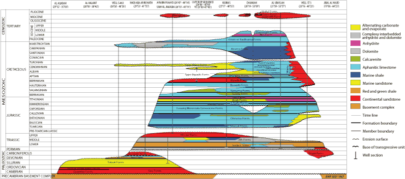
Plate II. Age relationships of Saudi Arabian sedimentary rock units.
Cretaceous (Cenomanian) |
Authors.- R.M.S. and S.N. , 1958.
Synonymy.- 'Ahmadi formation', and others, 1959; 'Ahmadi Member', and others, 1966; 'Ahmadi Formation', , 1967.
Type section.- Southeastern Kuwait. In Burgan well 62 between drilled depths 1,297 and 1,371 meters.
Reference section details:
Location: Safaniya well 17 (lat. 28°05'51"N, long. 48°45'57"E) between drilled depths 1,417.9 and 1,479.5 meters.
Thickness: 61.6 meters.
Lithology: Limestone and shale.
Fossils: Crusella intermedia , Trocholina lenticularis var. minima , Ammobaculites spp., Valvulina sp., and numerous ostracods.
Age: Cenomanian.
Underlying Formation: Wara Member of Wasia Formation; contact conformable, taken at change from limestone above to siltstone and sandstone below.
Overlying Formation: Rumaila Member of Wasia Formation; contact conformable, placed at sharp change from red-brown shale below to limestone above.
Other localities.- The Ahmadi Member has been identified with a fair degree of precision in all western Arabian Gulf oil fields from Safaniya and Zuluf to Qatif and Dammam. It has also been traced, with somewhat less certainty, across Ghawar to Niban.
Remarks.- The Ahmadi Member consists of two discrete lithologic units in all Arabian oil fields from Fadhili north. The upper part, formerly termed the Vulvulina shale, is typically brick-red to reddish-brown, highly fossiliferous shale. Underlying the shale is a limestone-shale sequence informally named the Caprock limestone. The Caprock cannot be identified south of Fadhili where equivalent beds are brick-red shale in the coastal fields of Abqaiq, Dammam and Qatif and alternating brick-red shale- and sandstone across Ghawar.
The Ahmadi Member shows little regional variation from an average thickness of about 55 meters. However, the Caprock-Vulvulina units, where present, exhibit substantial local and regional change in thickness, always one at the expense of the other.
The principal distinguishing feature of the Vulvulina shale is its reddish-brown color which is much darker in tone than other reddish-brown shale occurrences higher in the Wasia. The presence of a color change at the top of the Vulvulina interval is a widespread phenomena for it is at an equivalent point that the first reddish-brown shale appears in central Rub' al-Khali well sections below a long series of olive-gray shale and white limestone.
There is nothing in the upper part of the shale to distinguish it faunally from overlying shales. However, the lower part of the unit carries a distinctive microfossil assemblage which characterizes the Crusella intermedia zone.
As far as known, the top of the Crusella intermedia zone falls everywhere within the lower part of the Vulvulina shale. It is placed immediately above the highest appearance of Crusella intermedia , a form which very fortunately possesses a tolerance for widely differing ecologic conditions. The latter circumstance permits correlation between areas that otherwise have little in common either faunally or lithologically.
In coastal Arabia and southward through the central Rub' al-Khali the uppermost 2 to 6 meters of the Crusella intermedia zone may be marked only by the presence of the name-fossil. Below this level Trocholina lenticularis var. minima (= 'Orbitoides' of old Aramco reports) appears as do numerous ostracod species.
In Ghawar field the uppermost beds of the Crusella intermedia zone are marked by the presence of the name-fossil just as they are elsewhere. Below this level, however, faunas become rare and scattered and detailed correlations with coastal wells are not justified by the material. The general diminution both in number of species and number of individuals probably reflects. a trend toward brackish water and more sandy conditions. In Safaniya field, the thickness of Vulvulina shale below the top of the Crusella intermedia zone point is variable ranging from 17 meters in the southern end of the field to a probable minimum of around 6 meters in the northern end of the field. This variation in thickness is not accomplished by gain or loss of section, but rather by variation in stratigraphic position of the top of the underlying Caprock limestone.
At the southern end of the field the top of this limestone lies some 11 meters below the level of the Trocholina lenticularis horizon; in the northern part of the field the limestone top has moved upward through the section to a point immediately below the T. lenticularis horizon. At this extreme the top of the limestone is equivalent to the old 'Orbitoides limestone' of Dammam field and El Alat well 1 as well as the 'First pay' limestone of Bahrain.
The upper part of the Caprock limestone is porous and oil bearing in northern Safaniya. Here the unit reaches its maximum thickness (about 55 meters) and forms almost the whole of the Ahmadi Member. The porous beds have been designated as the Ahmadi reservoir.
See: Wasia Formation.
(Remarks in part after C.D. , 1962; unpublished report).
Cretaceous (Cenomanian) |
Term applied to porous beds within Caprock limestone, the basal unit of the Ahmadi Member, Wasia Formation. The reservoir contains productive oil in north Safaniya.
See: Ahmadi Member.
Eocene (middle Eocene) |
Informal name, applied to upper of two lithologic units within the Alat Member of the Dammam Formation.
See: Dammam Formation.
Eocene (middle Eocene) |
Informal term, used to define lower lithologic unit of the Alat Member, Dammam Formation.
See: Dammam Formation.
Eocene (middle Eocene) |
Upper of five members comprising the Dammam Formation.
See: Dammam Formation.
Eocene (middle Eocene) |
Name applied to middle of five members comprising the Dammam Formation.
See: Dammam Formation.
Jurassic (Lower Kimmeridgian and/or Tithonian) |
Author.- Unknown. First used in 1939; unpublished letter.
Synonymy.- 'Arab A member', published and unpublished works, 1939 to present (first published usage, ,
1951); 'Arab A', and ,
1951; 'Arab
'A' member', and ,
1956 and 1957; ''A' member'
and others, 1958 (formal definition); 'Arab 'A' member',
, 1962; 'Arab A reservoir', unpublished reports, 1964 to present; 'Arab-A
Member', P and others, 1966. See Plate III ![]() .
.
Click on the image to enlarge it.
Plate III. Arab Formation nomenclature.
Type section details:
Location: Dammam well 7 (lat. 26°19'04"N, long. 50°07'38"E) between drilled depths 1,371.6 and 1,388.4 meters.
Thickness: 16.8 meters.
Lithology: Aphanitic limestone, tan to brown, compact, with thin layers of brown calcarenite; minor anhydrite near top.
Fossils: Diceras sp.
Age: Upper Jurassic (Lower Kïmmeridgian and/or Tithonian) on stratigraphic position.
Underlying Member: B Member of Arab Formation; contact conformable, placed at sharp change from limestone above to anhydrite below.
Overlying Formation: Hith Anhydrite; contact conformable, taken at break from aphanitic limestone with minor anhydrite below to massive anhydrite above.
Other localities.- The member has not been identified on outcrop because of extensive solution-collapse effects. It does occur, however, in numerous wells east of the collapse zone (both in the Rub' al-Khali and northern areas) and has been penetrated in all oil fields.
Remarks.- The Arab-A Member embraces a thin, albeit widespread layer of shelf limestone deposited as part of an alternating sequence of normal marine carbonate and bedded evaporite. Removal of evaporites by solution is held responsible for the brecciation which characterizes Arab beds on outcrop.
In the subsurface the member can usually be correlated with confidence for it is typically and conformably sandwiched between units of massive anhydrite; the Hith Formation above and the Arab-B Member below. The unit can be readily traced into the northern and southwestern parts of the Rub' al-Khali but not into the central and eastern parts where equivalent beds though present are mainly in evaporite facies. It is lost entirely before the southern and eastern edges of the Rub' al-Khali are reached presumably through a combination of thinning and pre-Buwaib (pre-Hauterivian) truncation. Correlations also become approximate in the vicinity of Hafar al-Batin and Manifa as bracketing anhydrites are in whole or part replaced by limestone. The member wedges out to the west against the Buwaib Formation reaching only a short distance beyond Hafar al-Batin. Thickness of the unit, with few exceptions, falls between 10 and 20 meters.
The Arab-A Member is mainly in shoal facies north of Haradh. Clean-washed calcarenite is common to dominate in most wells although the section is coarsely crystalline dolomite similar to reef rock at Jauf and impure, apparently deeper-water aphanitic limestone at Safaniya. South of Haradh, calcarenite is virtually absent and clean, quiet-water, lagoon or open shallow shelf, aphanitic limestone - or its replacement equivalent dolomite - prevails.
The Arab-A reservoir - synonymous with the A Member - contains significant amounts of oil in Abu Hadriya, Berri, Dammam, Khursaniyah, and Manifa; minor accumulations occur in north Qatif and Abu Sa'fah.
See: Arab Formation and Arab-A reservoir.
Jurassic (Lower Kïmmeridgian and/or Tithonian) |
Name recently applied to upper of four carbonate intervals which, along with intervening layers of anhydrite, comprise the
Arab Formation (see Plate III ![]() ). Although synonymous with Arab-A Member, and in this sense a stratigraphic
term, the
interval has also been designated a reservoir as part of a general scheme to separate reservoir and stratigraphic units;
an important distinction where limits of the two, as is often the case, show
substantial divergence. The reservoir (= member) is widespread and embraces all porous beds whether or not the fluid they
contain is oil.
). Although synonymous with Arab-A Member, and in this sense a stratigraphic
term, the
interval has also been designated a reservoir as part of a general scheme to separate reservoir and stratigraphic units;
an important distinction where limits of the two, as is often the case, show
substantial divergence. The reservoir (= member) is widespread and embraces all porous beds whether or not the fluid they
contain is oil.
See: Arab Formation and Arab-A Member.
Jurassic (Lower Kïmmeridgian and/or Tithonian) |
Author.- Unknown. First used in 1939; unpublished letter. Redefined and others, 1966.
Synonymy.- None. See Plate III ![]() .
.
Type section details:
Location: Dammam well 7 (lat. 26°19'04"N, long. 50°07'38"E) between drilled depths 1,388.4 and 1,399.1 meters.
Thickness: 10.7 meters.
Lithology: Lower 6.1 meters aphanitic limestone, tan with thin interbeds of brown calcarenite; upper 4.6 meters anhydrite, white massive.
Fossils: None.
Age: Upper Jurassic (Lower Kimmeridgian and/or Tithonian) on stratigraphic position.
Underlying Member: C Member of Arab Formation; contact conformable, taken at sharp break from carbonate rock above to massive anhydrite below.
Overlying Member: A Member of Arab Formation; contact conformable, placed at change from massive anhydrite below to limestone above.
Other localities.- The unit has not been recognized on the surface as the area in which it would be expected to crop out is a jumble of complexly settled rocks; presumably the collapsed carbonate residue left behind when evaporite layers were removed by solution. East of the outcrop, however, the member has been recognized in numerous well sections in the Rub' al-Khali and northern Arabia.
Remarks.- The Arab-B Member defines one of four depositional cycles that make up the Arab-Hith complex. Each cycle begins with the accumulation of open-shelf calcareous sediments and closes with the onset of restricted circulation-lagoonal conditions and the precipitation of evaporite. As first used, the Arab-B Member, included only the carbonate part of the cycle (for example, and others, 1958). However, as the carbonate, together with its overlying anhydrite for all practical purposes represents a time-stratigraphic unit the member was redefined to include the anhydrite cap as well. Redefinition was doubly logical when regional work showed the carbonate-anhydrite contact to be interfingering and diachronous.
The unit is conformably bracketed by the Arab-A and -C Members except just west of Hafar al-Batin and near the southern and eastern edges of the Rub' al-Khali sand. In these areas the Arab-A Member butts out against the Buwaib Formation (Hauterivian). The subcrop area in which rocks of the Buwaib formation rest directly on Arab strata has not yet been penetrated, but nearby and flanking wells leave little doubt that this relationship actually obtains. For all practical purposes, the subsurface distribution of the Arab-B Member corresponds to that of the A Member. Thickness of the B Member varies little usually falling between 20 and 40 meters; slightly thicker sections have been noted, however, in the Manifa-Safaniya area.
When viewed on a regional scale, the proportion of limestone to evaporite within the member changes perceptibly. Near and west of wellsST-21, ST-12A, and Khurais, carbonate rocks make up 20 percent or less of the unit. Away from this area, the ratio of limestone to anhydrite progressively increases through facies change. The change is most pronounced to the north and northeast more than one half of the member is carbonate at El Haba, Fazran and Dammam and wholly so at Hafar al-Batin and Jauf.
Within the carbonate part of the Arab-B Member, facies trends are similar to those observed in the Arab-A. Atypical sections with little or no anhydrite occur at Safaniya, Jauf and near Hafar al-Batin where they are respectively: dark-colored, impure, possibly deeper-water aphanitic limestone; brown, coarsely crystalline, reef-like dolomite; and clean, shallow-shelf, aphanitic limestone and calcarenite. Between these wells and the general latitude of Haradh, concentrations of calcarenite are common. These disappear, however, in the northern and southwestern Rub' al-Khali where less agitated, shelf conditions prevailed and aphanitic limestone (or dolomite replacing aphanitic limestone) predominates; to the east mainly evaporite is present.
The carbonate part of the Arab-B Member, which corresponds to the
Arab-B reservoir
(Plate III ![]() ), contains oil in six Arabian fields; Abu Hadriya, Berri, Dammam, Khursaniyah, Manifa, and
Qatif.
), contains oil in six Arabian fields; Abu Hadriya, Berri, Dammam, Khursaniyah, Manifa, and
Qatif.
See: Arab Formation and Arab-B reservoir.
Jurassic (Lower Kïmmeridgian and/or Tithonian) |
The Arab-B reservoir includes the porous, carbonate portion of
the Arab-B Member (see Plate III ![]() ). The term has only recently been applied in a formal sense as part of an overall system to
obviously distinguish reservoir from stratigraphic units. The name is applied independent of whether or not the interval contains oil.
). The term has only recently been applied in a formal sense as part of an overall system to
obviously distinguish reservoir from stratigraphic units. The name is applied independent of whether or not the interval contains oil.
See: Arab Formation and Arab-B Member.
Jurassic (Lower Kïmmeridgian and/or Tithonian) |
Author.- Unknown. First used in 1939; unpublished letter. Redefined and others, 1966.
Synonymy.- None. See Plate III ![]() .
.
Type section details:
Location: Dammam well 7 (lat. 26°19'04'N, long. 50°07'38"E) between drilled depths 1,399.1 and 1,440.6 meters.
Thickness: 41.5 meters.
Lithology: Lower 28.7 meters calcarenite, tan to brown, generally fine-grained, moderately to strongly cemented with some thin beds of partially dolomitized aphanitic and calcarenitic limestone; upper 12.8 meters anhydrite, white to tan, massive with minor streaks of brown dolomite and limestone.
Fossils: None.
Age: Upper Jurassic (Lower Kimmeridgian and/or Tithonian) on stratigraphic position.
Underlying Member: D Member of Arab Formation; contact conformable, taken at change from calcarenite and dolomite above to white anhydrite below.
Overlying Member: B Member of Arab Formation; contact conformable, placed at sharp break between anhydrite below and dolomite above.
Other localities.- The unit has not been identified on outcrop owing to extensive collapse phenomena resulting from the loss of interbedded anhydrite. The member is present, however, in numerous wells to the east. Its distribution is essentially the same as that of the Arab-A Member.
Remarks.- The Arab-C Member, as now defined, is composed wholly of shallow-water sediments that reflect an interplay between two depositional regimes. The lower part of the member is mainly open-shelf neritic limestone although relict sea conditions were established from time to time bringing down thin interbeds of anhydrite particularly in the area from Ghawar and Khurais south. The upper part of the member is almost entirely bedded evaporite but hypersaline conditions obtained locally permitting precipitation of some halite layers in the western Rub'al-Khali.
As is the case in overlying members, Arab-C calcarenite generally occurs only north of the latitude of Haradh. South of this latitude, the carbonate part of the member includes an increasing amount of anhydrite and tight aphanitic limestone. Correlations are good exception the al-Batin and Jauf areas where the evaporite caprock has passed laterally into limestone and dolomite respectively and in the eastern Rub' al-Khali where individual members of the Arab Formation cannot be differentiated.
Thickest sections of the Arab-C Member occur in the area west, and southwest of Haradh. Here the unit is more than 75 meters thick, roughly 70 per cent of which is evaporite. Overall thickness decreases gradually but persistently in all directions away from this area reaching about 45 meters in the vicinity of Hafar al-Batin, along the present Arabian Gulf coast, in the central Rub' al-Khali, and at al Jaladah. A decrease in the proportion of evaporite follows roughly the same pattern but with a definitely steeper gradient to the north and northeast. The member is about evenly split between carbonate and evaporite along Ghawar and Abqaiq and a short distance north of El Haba. It is limestone throughout at Hafar al-Batin and wholly replacement dolomite at Jauf; only thin vestiges of evaporite tongues persist into the impure, somewhat deeper water limestone facies that occurs at Safaniya.
Significant quantities of oil are present in the Arab-C Member at Abqaiq, Abu Hadriya, Abu Sa'fah, Berri, Dammam, Khursaniyah, Manifa, and Qatif; a minor accumulation has been found in northern Ghawar.
See: Arab Formation and Arab-C reservoir.
Jurassic (Lower Kïmmeridgian and/or Tithonian) |
Term used only recently in formal sense to define the porous, carbonate part of the
Arab-C Member (see Plate III ![]() ). The base of the reservoir coincides with the base of the member; the upper limit, marked by a
change from limestone to anhydrite, is slightly
though obviously diachronous when viewed on a regional scale. Widely tested, the reservoir - a term used indiscriminate of fluid content- contains oil and/or water throughout.
). The base of the reservoir coincides with the base of the member; the upper limit, marked by a
change from limestone to anhydrite, is slightly
though obviously diachronous when viewed on a regional scale. Widely tested, the reservoir - a term used indiscriminate of fluid content- contains oil and/or water throughout.
See: Arab Formation and Arab-C Member.
Jurassic (Lower Kïmmeridgian) |
Author.- Unknown. First used in 1939; unpublished letter. Redefined and others, 1966.
Synonymy.- None. See Plate III ![]() .
.
Type section details:
Location: Dammam well 7 (lat. 26°19'04"N, long. 50°07'38"E) between drilled depths 1,440.6 and 1,499.1 meters.
Thickness: 58.5 meters.
Lithology: Lower 46.0 meters aphanitic limestone, tan to brown, partially dolomitized with common interbedded clean-washed, porous calcarenite and calcarenitic limestone and some dolomite; upper 12.5 meters anhydrite, white, massive with thin interbeds of dark-brown dolomite and strongly dolomitized calcarenite.
Fossils: Clypeina jurassica , C. cf. hanabatensis & , Cylindroporella arabica , Polygonella incrustata , Kurnubia spp. and Nautiloculina spp.
Age: Upper Jurassic (Lower Kimmeridgian) on contained fossils and stratigraphic position.
Underlying Formation: Jubaila Formation; contact conformable, taken at change from porous calcarenite above to tight aphanitic limestone below.
Overlying Member: C Member of Arab Formation; contact conformable, placed at break from white anhydrite below to calcarenite and dolomite above.
Other localities.- The Arab-D sequence has not been recognized in its entirety on outcrop owing to extensive solution of anhydrite beds and subsequent slumping and brecciation of the carbonate units left behind. Most of the lower carbonate beds seem to be present in the vicinity of Sha'ib Nisah and again between Sha'ib Haddar and Wadiad Dawasir but even within these sections a persistent brecciated zone suggests that at least one thin layer of evaporite was originally included. Anhydrite - presumably equivalent to the upper part of the D member - is known only from sporadic outcrops in the Sha'ib Haddar-Wadi ad Dawasir area. The member, widespread in the subsurface, has been encountered in all oil fields and numerous wells east of the outcrop belt. Its distribution is essentially the same as that of the Arab-A Member.
Remarks.- Extensive remarks on this member can be found in ,
1962 where it is synonymous with the upper Arab D
plus the C-D anhydrite (See
Plate III ![]() ).
).
The carbonate part of the Arab-D Member, with the possible exception of Safaniya, is composed entirely of clean, neritic limestone; limestone that is nearly everywhere characterized by abundant carbonate sand and gravel, commonly skeletal and commonly in the form of massive clean-washed calcarenite-calcirudite beds. Regionally, the carbonate succession shows considerable paleogeographic differentiation. The picture to emerge is that of sedimentation on a broad, gently undulating, slightly submerged shelf. In the north, from the present area of outcrop eastward to at least as far as Abu Sa'fah and Manifa, great quantities of calcareous sand accumulated in the form of offshore bars and banks; mainly lime mud settled in the interbar areas. In the south, that is, in the central and western Rub' al-Khali, finer grained, lagoonal sediments prevailed.
Deposition of limestone persisted until precipitation of anhydrite commenced. Penesaline conditions obtained first in the Rub' al-Khali and interior part of northeastern Arabia while normal carbonate sedimentation continued without interruption in the northern Ghawar and coastal areas. The evaporitic sea expanded north and east progressively overlapping the limestone succession to Abu Sa'fah and Manifa and beyond, blanketing it with a thin interval of nearly pure anhydrite.
The carbonate or reservoir portion of the Arab-D Member contains significant quantities of oil at Abu Sa'fah, Abqaiq, Damman, Fadhili, Ghawar, Khurais, Khursaniyah, and Qatif. It is, by far, the most important reservoir so far discovered in the Arabian Peninsula.
See: Arab Formation.
Jurassic (Lower Kïmmeridgian) |
Informal name applied to main-producing interval in Saudi Arabia. The Arab-D reservoir was originally defined on the presence of productive oil and is therefore not strictly a part of formal stratigraphic nomenclature. However, because of its distinctive lithology and nearly isochronous character over a broad area, it has subsequently been used, almost without exception, in a stratigraphic sense independent of its fluid content.
Extensive remarks on this reservoir can be found in
(1962) where it equates with the combined upper, middle and lower
Arab-D units (see Plate III ![]() ). The contact between the
Arab and Jubaila Formations in terms of the outcrop sequence falls near the middle of the Arab-D reservoir. Acurate identification of this boundary has proved of considerable importance for it divides the reservoir into two parts each with a decidedly different lithogenetic character and reservoir behavior.
). The contact between the
Arab and Jubaila Formations in terms of the outcrop sequence falls near the middle of the Arab-D reservoir. Acurate identification of this boundary has proved of considerable importance for it divides the reservoir into two parts each with a decidedly different lithogenetic character and reservoir behavior.
Arab-D reservoir rocks represent the transition from continuous carbonate deposition to precipitation of nearly pure anhydrite. The lower part of the reservoir consists of mixed calcareous mud and nonskeletal sand grains. Aphanitic limestone is the main rock type; calcarenitic limestone follows. The high concentration of calcareous mud would suggest that the particles accumulated for the most part below the effective wave base of the time. The paucity of skeletal grains tends to bear this out. Sporadic occurrences of clean-washed calcarenite near the top indicate that locally, less sheltered, presumably bottom-high conditions obtained from time to time. Near the middle of the reservoir a thin persistent unit of aphanitic limestone - the top of which corresponds to the Arab-Jubaila boundary - records an episode of muddy deposition over a wide area. It can be inferred that this unit was deposited for the most part in areas or at depths where current activity was low.
The upper part of the Arab-D reservoir is characterized over a wide area by major concentrations of carbonate sand and gravel, much of it clean washed, and a considerable increase in skeletal components, particularly dasyclad algae, stromatoporoids, and foraminifera. Increased sand and skeletal content persisted until precipitation of anhydrite commenced. This change from dominantly mud sedimentation in the lower part of the reservoir to accumulation of muddy sand and massive calcarenite with quantities of dasyclad algae marks the start of widespread and persistent shoaling of the sea floor into the zone of vigorous photosynthetic activity.
The Arab-D reservoir contains productive oil in eight widely scattered fields - Abqaiq, Abu Sa'fah, Dammam, Fadhili, Ghawar, Khurais, Khursaniyah, and Qatif. Areas of maximum oil accumulation correspond rather closely to trends of major calcarenite development. Voids, now oil filled, are essentially those formed between sand grains at the time of deposition, and have since undergone little significant modification.
See: Arab Formation, Arab-D Member, and Jubaila Formation.
Jurassic (Lower Kïmmeridgian-Tithonian) |
Author.- Not established, first-known usage is that of R.A. , 1951; unpublished work.
Synonymy.- 'Lower Riyadh
Formation', unpublished reports, 1938-49; 'Arab Zone', published and unpublished reports 1938-64 (first published usage as zone, ,
1949); 'Arab Zone', and ,
1951;
'Arab formation', and ,
1952 (first formal usage as formation); 'Arab zone', ,
1955; 'Arab Zone', ,
1955; 'Arab formation', and ,
1956 and 1957; 'Arab
formation', and others, 1958
(first formal definition); 'Arab Formation',
and others, 1966. See Plate III ![]() .
.
Type section details:
Location: Dammam well 7 (lat. 26°19'04"N, long. 50°07'38"E) between drilled depths 1,371.6 and 1,499.1 meters.
Thickness: 127.5 meters.
Lithology: Interbedded limestone and anhydrite. Calcareous intervals are comprised of aphanitic limestone, calcarenitic limestone, calcarenite, and dolomite in varying proportions; all are subdued tones of gray or brown.
Fossils: Diceras sp., Nerinea sp., Clypeina jurassica , C. cf. hanabatensis & , Cylindroporella arabica , Polygonella incrustata , Kurnubia spp. and Nautiloculina spp.
Age: Upper Jurassic (Lower Kimmeridgian-Tithonian) on stratigraphic position and correlation with other subsurface sections.
Underlying Formation: Jubaila Formation; contact conformable, taken at downward change from clean-washed calcarenite to tight aphanitic limestone.
Overlying Formation: Hith Anhydrite; contact gradational, taken at change from aphanitic limestone below to massive anhydrite above.
Other localities.- Rocks of the Arab Formation form a thin, essentially unbroken belt from Al Hasi (lat. 20°08'N) to Juwayy (lat. 25°49'N), a distance of nearly 700 kilometers. Width of the outcrop over this distance is relatively uniform averaging about10 kilometers. The formation is widespread in the subsurface and has been penetrated in all oil fields. In the north, it is found in bore holes as far west as Al Batin; in the south, it occurs in all wells but those along the southern and easternmost fringes of the Rub'al-Khali.
Remarks.- The area of Arab Formation exposure is mainly a broad, gently undulating plain. A few low, isolated hills 'haystack jibal' stand above the general ground level. Effects of slumping are everywhere evident - a phenomenon that can be readily attributed to the removal of anhydrite beds and the subsequent collapse of the carbonate units left behind. The little that is known of the basic rock types on outcrop indicates they are similar to the calcarenite-calcarenitic limestone-aphanitic limestone-dolomite rocks found in wells to the east.
No satisfactory estimate of the total thickness of the Arab Formation at the surface has been made because of the complex slumping. Only the basal 15 to 25 meters has been measured with any assurance, and even this interval contains a persistent brecciated zone that suggests some loss of section due to anhydrite solution. There is every reason to believe that this basal Arab carbonate unit is equivalent to the lower part of the type D Member at Dammam; it may well represent the total D Member not replaced by anhydrite in well sections at Khurais and Ma'aqala.
Only at the southern end of the solution-collapse zone have beds been found in place above the basal unit described above. Between Sha'ib al Haddar and Al Hasi, outcrops of anhydrite rest directly on the laterally persistent calcarenite that marks the top of the basal sequence. These overlying beds have an average thickness of about 14 meters and are mainly white anhydrite and gypsum with thin interbeds of brown dolomite.
At first the type locality of the Arab Formation was taken as a general area around the city of Ar Riyad. Extensive loss of beds and subsequent slumping prevented accurate measurement of section, however, and forced selection of a subsurface sequence to best represent the unit.
In well sections, the Arab Formation is defined to include four main cycles of deposition each of which started with shallow-water, normal marine carbonate and closed with precipitation of nearly pure anhydrite, probably first deposited as gypsum. The carbonate portions of each cycle have been designated consistently but informally from top to bottom as the A, B, C, and D members of the Arab Formation. The boundary between the carbonate units and their capping anhydrites is known to be diachronous in at least two cases and perhaps it is in all. This, coupled with the fact that each carbonate-anhydrite cycle taken as a whole approximate a time-stratigraphic unit, prompted redefinition of the lower three members to include their anhydrite caps ( and others, 1966). The much thicker upper or closing anhydrite interval is still considered a separate formation - the Hith Anhydrite.
Dammam well 7 serves as the type locality for the Arab Formation and its members: the A Member, between 1,371.6 and 1,388.4 meters depth; the B Member between 1,388.4 and 1,399.1 meters depth; the C Member between 1,399.1 and 1,440.6 meters depth; and the D Member from 1,440.6 to 1,499.1 meters depth. In each instance, the contact between members is marked by change from carbonate to evaporite. (For additional details see discussions on individual members.)
The episodic pattern of Arab deposition is clearly documented inmost well sections where 5 to 50 meter-thick intervals of shallow-water, shelf limestone sharply alternate with layers of penesaline rocks of like thicknesses. The depositional regimen was controlled by alternating periods of desiccation and influxes of freshening sea water.
Continuity of individual evaporite units makes regional correlation of the Arab members a relatively simple matter. There is some difficulty, however, in recognition of various members in the Al Batin-Jauf-Manifa area due to loss of anhydrite by facies change to carbonate.
From Haradh northward, limestones of the Arab Formation are characterized by a high percentage of lime sand, commonly skeletal and commonly in the form of massive clean-washed calcarenite beds. Calcarenitic limestone is the next most frequent rock type; pure aphanitic limestone and dolomite are quite rare except at Jauf where the entire unit is coarsely crystalline dolomite. Reef structures have not yet been found and the wide continuity, uniform thickness, and regularly bedded nature of the Arab suggest that large structures of this type are unlikely.
Specific particle types contributing to Arab Formation calcarenites and calcarenitic limestone include calcareous algae, stromatoporoids and foraminifera as the main skeletal elements, and aggregate pellets, 'algal' nodules, and 'fecal' pellets as the most important non-skeletal grains. Ooliths are rare although some concentrations occur in the C Member at Khursaniyah and in the C and D Members at Manifa.
South of Haradh, in the Rub' al-Khali area, carbonate intervals are thinner and consist almost entirely of aphanitic limestone and dolomite with occasional layers of mud-based calcarenitic limestone. Few true clean-washed calcarenite beds are present. The widespread accumulation of finer-grained sediments suggests Arab rocks of this area were deposited mostly below effective wave base.
Thickness of the Arab Formation usually ranges from 100 to 180 meters. However, thinner intervals occur around the edges of the Rub' al-Khali basin and at Ath Thumami where upper members are truncated by pre-Buwaib (pre-Hauterivian) erosion. Otherwise, except for Jauf where the whole of the upper Jurassic is coarse dolomite, the Arab is conformably overlain by massive, with anhydrite of the Hith Formation. The lower contact with the Jubaila Formation is also conformable, almost everywhere marked by change from quiet-water, muddy limestone to current-washed limestone characterized by lime sand, commonly skeletal and commonly in the form of massive, clean, calcarenite beds.
Thicknesses of individual members change little from the coastal area toward outcrop. Each anhydrite bed does, however, thicken considerably; a change compensated for by thinning of the underlying carbonate unit. There is little doubt that, to the west and south carbonate beds are progressively replaced from the top down by facies change to anhydrite. In fact, regional considerations show maximum evaporite thickness occurs along a north-south line near the longitude of Ar Riyad. This is borne out by the fact that the amount of carbonate rocks remaining in the solution-collapse zone is small and the interval was apparently mostly soluble anhydrite. That hypersaline conditions obtained from time to time is attested to by the fact that at Khuirais, Haradh and in the western Rub' al-Khali, salt occurs in the upper members of the Arab, normally in beds less than 10 meters thick.
The rather limited fauna so far recorded from surface exposures of the Arab Formation has not proved diagnostic. Except for Diceras, identifiable forms range down into the Jubaila below. Consequently, the subsurface sequence provides the only means of dating Arab rocks.
Kurnubia spp., Nautiloculina spp., Clypeina jurassica, C. cf. hanabatensis, Cylindroporella arabica, Polygonella incrusta and Salpingoporella sp. range throughout the Arab-D Member (, 1962). Although some elements of this assemblage extend on into the A Member, it is only the D beds that have been reliably dated. These can be equated to at least part of and 's (1959) group g beds through the No. 4 limestone of Dukhan oil field in Qatar; the direct equivalent of the D Member of Saudi Arabia.
and (1959) also list Calpionella alpina , Pseudocyclammina sp., and Burgundia steinerae from group g and equivalent beds. By comparison with the Alam Abyadh limestones of southwest Arabia, the Cidaris glandarius beds of the Lebanon and Kurnub, and with other formations, they conclude the faunas are Sequanian (early Kimmeridgian) in age, a date compatible with other lines of evidence.
The post-D Member Arab Formation and the Hith Anhydrite have not yet been dated. But, as these beds occur between known Lower Kimmeridgian and presumed Berriasian (Lower Cretaceous), it seems safe to assume that they are, at least in part, Tithonian.
Although all members of the Arab Formation contain oil, accumulation in the thinner A, B, and C carbonates is much less extensive than in the D Member. Arab-A, and -B oil occurs in Abu Hadriya, Abu Sa'fah, Berri, Dammam, Khrusaniyah, Manifa, and Qatif. The C Member contains oil at the same fields plus minor accumulations in northern Ghawar and Abqaiq. Arab-D Member oil has been encountered at Abqaiq, Abu Sa'fah, Dammam, Fadhili, Ghawar, Khurais, Khursaniyah, and Qatif. In all these fields, the 25- to 40-meter-thick D Member, as well as the upper 45 or so meters of the underlying Jubaila Limestone are oil saturated.
The major oil deposits in the Arab Formation accompany maximum development of porous calcarenite. It is certain that intergranular pore spore associated with the rocks at the time of deposition almost exclusively controls present distribution of oil. To be sure, diagenetic changes including recrystallization, dolomitization, and cementation have all modified the original pore pattern to some extent but, in each case, the effect has not been drastic.
See: Riyadh Formation.
Jurassic (Lower Kïmmeridgian-Tithonian) |
Abandoned name proposed late in 1938 to embrace productive rocks ... 'of the deep horizon of Dammam Dome'. The name was based on the oil-saturated intervals penetrated at that time and as such included what is now known as the Arab-A, -B and -C Members. It was later extended downward to the top of the Jubaila Formation to include the prolific D Members as well. With this definition, the term Arab Zone, is essentially equivalent to Arab Formation and prior to abandonment it was extensively used in this sense; also synonymous with lower Riyadh formation. First published usage was in (1949).
See: Arab Formation.
Cretaceous (?Coniacian-Maestrichtian) |
Authors.- H.L. and J.W. , 1935; unpublished report.
Synonymy.- 'Aruma formation', and , 1952 (first published reference); 'Aruma formation', and others, 1958 (formal definition); 'Aruma group', and , 1958; 'Aruma group', and others, 1959; 'formation de l'Aruma', , 1962; 'Aruma Formation', and others, 1966.
Type section details:
Location: Al 'Aramah plateau. Type sequence composited from several sections along a traverse from Khashm Khanasir (lat. 25°38'12"N, long. 46°22'9"E) northeast to a point on the back slope of Al 'Aramah escarpment (lat. 25°39'18"N, long. 46°23'30"E), thence northeast to a promontory (at lat. 25°44'35"N, long. 46°30'41"E) in which the top of the Aruma Formation is exposed.
Thickness: 141.5 meters.
Lithology: Divided into four lithologic units from top to bottom. Unit 4-32.9 meters yellow-brown dolomite and calcareous shale, olive shale, and argillaceous dolomite, with interbedded limestone and dolomite. Unit 3-27.6 meters blue-gray to cream dolomite with some limestone near top. Unit 2-41.0 meters consisting of 38 meters of fine-grained chalky limestone, and a basal 3-meter bed of olive-green calcareous shale. Unit 1-40.0 meters cream, fine-grained calcarenitic limestone with impure and sandy layers near bottom, commonly with basal bed of red-brown vuggy dolomite.
S.J. (1952, unpublished report) recognized two units at the type locality that served to group most of the shale and impure carbonate into a single member - the Lina (= Unit 4) - overlying a somewhat cleaner carbonate sequence - the Atj member (= Units 1, 2 and 3 combined). This subdivision, never formally adopted, has some merit as has demonstrated a disconformable contact between the two members, a contact that has widespread subsurface expression with some angular discordance. Unfortunately, the lateral continuity of the two units has never been systematically demonstrated beyond the limits of Al Aramah plateau.
The presence in the subsurface of a widely recognizable stratigraphic break within the Aruma Formation has led to the division of the formation into two parts, the Upper Aruma and the Lower Aruma. Normally, the Upper Aruma is introduced by a shale or shaly limestone transgression carrying one or another of two laterally equivalent microfaunas. In the type section the Upper Aruma is represented by the upper three lithologic units, a total of 101.5 meters. The lowermost unit of the type section, 40 meters thick, probably represents only the upper part of the Lower Aruma of coastal Arabia.
Fossils (list partly compiled from laterally equivalent well sections): Unit 4-Foraminifera present include Elphidiella multiscissurata , Fissoelphidium operculiferum , Omphalocyclus macroporus (), Loftusia sp., Minouxia steinekei , Glyphostomelloides globosus , Arumella ornata , and Fissoelphidium nasutum ; ostracods include Hyctereis arabica and Hyctereis spinosa as well as forms closely resembling the species figured but not described by (in press, plate 2, figure 8); megafossils are represented by Austrosphenodiscus sp., Cyclolites medlicotti , and various rudistids. Unit 3-Highest occurrences of Lepidorbitoides spp., Chrysalidina hensoni , Glaessnerella cretacica , Messinaella vestae , Loeblichella gallowayi , and Cryptoglyphus arabicus . Unit 2-Preservation poor but probably carries most of above-listed foraminifera; in addition, the 10-meter limestone interval immediately above the basal shale bed carries Orbitoides gensacicus () and the lowest occurrences of Omphalocyclus macroporus (); the basal shale of Unit 2 appears to beat least partially equivalent to beds which elsewhere carry either the form discussed and figured by (1952, p. 240, plate 23, figs. 1-7) as Monolepidorbis douvillei or, in presumably deeper water environments, Sirtina orbitoidiformis & . Unit 1-Monolepidorbis sanctae-pelagiae in upper part and Rotalia trochidiformis () and Meandropsina vidali throughout; megafossils include Ostrea cf. O. verneuili , Ostrea dichotoma , Hemipneustes sp., Sphenodiscus acutodorsatus , and Nerinea ganesha .
Age: The Lower Aruma of the type area probably falls entirely within the Campanian as sphenodiscid ammonites occur near its base and Monolepidorbis sanctae-pelagiae, a foraminifer described from the Campanian of Spain, occurs near its top. The age of the basal shale interval of the Upper Aruma is in some doubt, but Omphalocyclus macroporus () appears immediately above it and ranges to within a meter of the top of the formation, thus placing the entire interval above the basal shale in the Maestrichtian.
Expanded sections of the Aruma Formation found in the subsurface contain beds which may be as old as Coniacian (see Other Localities).
Underlying Formation: Over most of the outcrop the Aruma Formation lies disconformably upon the varicolored clastic sediments of the Wasia Formation. Angular discordance is not usually evident, but in the vicinity of Sakakah the Aruma completely overlaps the Wasia, resting upon older and older beds as the contact swings around to the southwest. In the subsurface, some structures, such as Ghawar, Abqaiq, Khursaniyah and Safaniya, show distinct angular discordance at the base of the Aruma. Other structures, however, show little trace of discordance at this level, and there seems to be complete concordance of attitude between the Wasia and the Aruma in all off-structure positions.
Overlying Formation: Along the eastern margin of the outcrop area and in the subsurface the Aruma Formation is everywhere overlain by the Umm er Radhuma Formation. The formational boundary may represent a disconformity, but beds above and below it appear to be essentially parallel throughout most of Saudi Arabia. However, the Umm er Radhuma zonation published by (1954, p. 3) suggests that the lowermost faunal unit present in Saudi Arabia is not represented in Qatar, possibly having been lost by progressive onlap onto the Qatar structural high.
North of Sakakah, the Aruma Formation is overlain by a cherty, nummulitic limestone of Paleocene or Eocene age that was apparently not directly related to the Umm er Radhuma basin of deposition. Little work has been done in this area and the exact nature of the contact is unknown.
Other localities.- Occurs in all deep wells east of the outcrop, but usually in increased thickness, ranging up to more than (170 meters on the flanks of Abu Hadriya field. Part of this expanded section is caused by an increase in the rate of sedimentation, but part of it is caused by the addition at the bottom of the section of beds older than any exposed at the outcrop. Such beds have been included in the Aruma of the subsurface because they initiate the Aruma transgression, unconformably overlying the Mishrif Member of the Wasia Formation. They are best developed at Abu Hadriya, Qatif, and Dammam fields, and presumably gradually lap out to the west against the post-Wasia erosional surface.
The higher beds of the added section are predominately limestone. At Safaniya, this part of the section contains a faunule, chiefly Kathina sp. and Cosinella sp., considered to be Santonian in age. Through most of the coastal area the Aruma Formation has a predominately shale interval at its base (alternating limestone and shale at Safaniya). The upper beds of this basal shale interval commonly carry Planoglobulina sp., a form indicative of an age no greater than Coniacian. The age of the lower part of the shale interval is still in doubt.
Remarks.- There are two principal microfaunal facies developed in the upper part of the Lower Aruma. The first of these, a pelagic-rich facies with Globotruncana calcarata , Globotruncana cf. G. elevata (), and Globotruncana fornicata carries a large and varied fauna indicative of accumulation in deep water. The second facies is lacking in pelagic elements, and appears to represent a shallow-water environment. It carries such forms as Monolepidorbis sanctae-pelagiae , Meandropsina vidali , and a small Arumella sp. The pelagic facies is present in Ghawar field and all of coastal Hasa. The non-pelagic facies is found in the Rub' al-Khali, in Khurais field, in water wells and structure drill holes south and west of Khurais field, and along the Aruma outcrop.
In the northern part of the Aruma outcrop, relatively marked changes occur with the appearance of a major lens of sandstone in the lower part of the section. At Khashm Zallum (lat. 30°18'N, long. 40°21'E) 61 meters of sandstone overlies an 11 meter thick basal Aruma limestone unit. The sandstone - informally termed the Zallum sandstone - is locally poorly indurated, fine- to medium-grained, and subrounded. Striking colors of white, gray, brown and purple prevail, particularly on weathered surfaces. Near the base, concentrations of cobbles and pebbles of chert, quartz and quartzite are locally common.
From Khashm Zallum the sandstone can be traced southwest in the face of Jal al Amghar to Khashm al Makhruq (lat. 30°03'N, long. 40°40'E) and then east for about 15 to 20 kilometers where it thins slightly and undergoes a rapid facies change to marly dolomite, dolomite and limestone; rock types typical of the Aruma further south. Northeast of Khashm Zallum, the sandstone crops out in the upper reaches of Wadi Ar'ar directly under Aruma limestone and can be traced as far as Al Mu'tadil (lat. 30°31'N, long. 40°27'E).
The Zallum sandstone has been identified as the cap rock on Jabal Qiyalal Kabir (lat. 30°06'N, long. 40°05'E) and in sporadic outcrops as far as the Jordan border.
(C.D. , supplemented R.W.P.).
Jurassic (?Upper Bathonian) |
Author.- J. S. , 1961; unpublished report.
Synonymy.- 'Fadhili zone', , 1955; 'Fadhili zone', and , 1956; 'lower Fadhili reservoir', unpublished reports 1963-66; ''Atash Member', and others, 1966 (first formal definition).
Type section details:
Location: Khashm al 'Atash (lat. 24°10'50"N, long. 46°27'53"E) where upper 14.1 meters are cleanly exposed; lower 12.2 meters are taken from a shallow air-drilled hole, T-80, spudded in at base of upper 14.1 meter section.
Thickness: 26.3 meters.
Lithology: Aphanitic and calcarenitic limestone, tan and golden-brown, chalky, with single bed of calcarenite near middle and layer of coralliferous limestone near the top.
Fossils: Eligmus rollandi , E. rollandi var. jabbokensis , Eudesia cardium (), E. cardioides , Gryphaea costellata , Homomya inornata (J. de C. ), Mactromya aequalis , Pholadomya aubryi , P. lirata (J. ), 'Terebratula' cf. superstes , Kurnubia variabilis , Nautiloculina spp., Pfenderella arabica , Pfenderina gracilis , P. trochoidea & , P. neocomiensis & , Pseudomarssonella maxima , P. plicata , Sanderella laynei , and Trocholina spp.
Age: ?Upper Bathonian on contained fossils and stratigraphic position.
Underlying Unit: Dhrumaites zone of middle Dhruma; contact conformable, placed at change from chalky calcarenitic limestone above to calcarenitic limestone below.
Overlying Unit: Hisyan Member; contact conformable, taken at sharp break from golden-brown calcarenite below to yellow-gray shale above.
Other localities.- On outcrop north and south of type locality and in numerous wells from the central Rub' al-Khali to Abu Hadriya and Al Batin.
Remarks.- Details on lithology, distribution, etc. of the 'Atash Member are given in the section on Dhruma Formation. It is worth emphasizing, however, that the 'Atash Member is equivalent, both lithologically and faunally, to the subsurface lower Fadhili reservoir - an important oil-bearing interval in onshore Arabia.
See: Dhruma Formation.
Cretaceous (Campanian-Maestrichtian) |
Informal name, see Aruma Formation.
?Jurassic (?Tithonian) |
Obsolete name applied to the thin but highly distinctive rock sequence which intervenes between the sharply defined top of the 'main' anhydrite of the Hith Formation and the base of the tight aphanitic limestone of the Sulaiy Formation. The sequence, on the average about 60 feet thick, is mainly oolite calcarenite with variable amounts of nodular anhydrite, bedded anhydrite and aphanitic carbonate. It has been identified at Ghawar and Khurais and fields to the north.
Originally considered the basal member of the Sulaiy Formation, subsequent data showed it more logically to be part of the Hith Anhydrite. The unit was informally redesignated as the 'upper calcarenite member' of the Hith Formation.
With the discovery of oil at Manifa in 1957 in what is believed to be exactly equivalent beds, the interval was first named the Manifa zone and then, more formally, designated as the Manifa reservoir.
Carboniferous (Tournaisian - ?Westphalian) |
Authors.- D.O. and R.W. , this report. Synonymy.- None.
Type section details:
Location: Well ST-8; lat. 29°53'21"N, long. 41°54'44"E. The formation is between drilled depths 4358 and 4982 feet (1328.3 and 1518.5 meters).
Thickness: More than 190.2 meters; base of formation not penetrated.
Lithology: Sandstone, fine- to coarse-grained, argillaceous; common interbeds of siltstone, some shale.
Fossils: Well preserved microspores occur at several levels. Raistrickia, Convolutispora and Reticulatisporites are found near the top of the formation; the middle and lower parts contain Cristatisporites, Asperispora, Densosporites, Vallatisporites, Spinozonotriletes, Diatomozonotriletes, Knoxisporites, Acanthotriletes, Cincturasporites and Anapiculatisporites. (All palynological identification by D.O.
Age: Lower and Upper Carboniferous (Tournaisian -?Westphalian).
Underlying Formation: Not penetrated; presumed on regional considerations to be Jauf Formation.
Overlying Formation: Khuff Formation; contact unconformable, placed at change from sandstone with Carboniferous microflora below to varicolored sandy shale with Upper Permian microflora above.
Other localities.- None known. The formation is not exposed at the surface and has not been identified in any subsurface section other than at ST-8.
Remarks.- The Berwath Formation is presumed non-marine on the presence of abundant spores of vascular plants, its varicolored clastic sediments, and lack of definite marine remains. No correlatives of the Berwath Formation have so far been identified in Saudi Arabia; however, continental sediments of uppermost Carboniferous (?Stephanian) age are present at well ST-7 (lat.17°29'N, long. 47°07'E) and other localities in the southeastern part of the Arabian Peninsula.
Cretaceous (Barremian - ?Cenomanian) |
Author.- R.A. , 1952; unpublished report.
Synonymy.- 'Biyadh sandstone', and , 1956 (first published usage) and 1957; 'Biyadh sandstone', and others, 1958 (first formal definition); 'Biyadh Sandstone', and others, 1966.
Type section details:
Location: Along a two-part traverse from base of sandstone at lat. 24°06'38"N, long. 47°23'53"E east to lat. 24°05'28"N, long. 47°38'07"E and from lat. 24°00'03"N, long. 47°35'09"E southeast to lat. 23°58'38"N, long. 47°41'37"E.
Thickness: About 425 meters, calculated.
Lithology: Sandstone, cross-bedded, quartz; some varicolored shale.
Fossils: None.
Age: Lower Cretaceous (Barremian - ?Cenomanian) on correlation with subsurface sections.
Underlying Formation: Buwaib Formation; contact conformable and gradational from black-weathering, cross-bedded sandstone above to sandy dolomite and limestone below.
Overlying Formation: Wasia Formation; contact unconformable, taken at change from coarse-grained quartz sandstone below to ferruginous silty sandstone above.
Other localities.- Sandstone of the Biyadh can be traced almost continuously from Wadi ad Dawasir to Wadi al Atk, a distance of nearly 650 kilometers. Only two breaks of any significance occur in this distance and these are the synclinal area of Wadi as Sahba where younger sediments effectively mask the Biyadh and the gravel sheet at Al Aflaj (about lat. 22°10'N).
The formation has also been identified in most wells drilled east of the zone of outcrop. It is known to underlie the whole of the Rub' al-Khali, the entire Eastern Province and the adjacent offshore area as well.
Remarks.- The Biyadh Formation on outcrop embraces a thick sequence of brown- to black-weathering, cross-bedded sandstone with some varicolored shale, conglomeratic layers and thin beds of ironstone. The bulk of these sediments appear to be nonmarine, a testimonial to widespread and prolonged emergence of the Arabian interior. At least one short cycle of marine transgression is indicated, however, for, from Wadi as Sahba north, a prominent 10-meter interval of complexly interbedded clastic and carbonate rocks occurs about three-fourths of the way up from the base of the formation. The interval contains poorly preserved marine molluscs. In addition, a non-diagnostic marine microfauna was found in an air-drilled hole 25-30 meters below the base of the mollusc-bearing interval.
Eastward from the area of outcrop sandstone slowly but progressively gives way to shale. Sandstone and a continental aspect still dominate the sequence, however, east to the 49th meridian from the Rub'al-Khali to Safaniya. From this longitude, clastic elements of the Biyadh Formation grade eastward into marine shale and limestone. Addition of limestone in this direction is rapid and transition of the entire sequence to normal marine, neritic limestone is, for all practical purposes, complete at the 51stmeridian both in the north and the south.
Ghawar, Abqaiq, Dammam and fields to the north fall in the area where shale, sandstone and limestone complexly intertongue. Here beds of the Biyadh and upper part of the Buwaib form a heterogeneous but natural unit which, before accurate placement of the Buwaib-Biyadh contact in the subsurface, was informally but consistently referred to as the 'Greenish gray shale' (obsolete). The top of the 'Greenish gray shale' exactly corresponded to the top of the Biyadh Formation as presently defined in the subsurface. The base fell at a level in the Buwaib Formation that marks the top of the Chrysalidina zone (= old 'Valvulinella zone'). See remarks under Buwaib Formation.
In Dammam, Bahrain, and Qatif two relatively thin limestone members within the 'Greenish gray shale' are characterized by common specimens of Orbitolina discoidea . These were in the early years designated as the First Orbitolina discoidea bed and Second Orbitolina discoidea bed. These beds, however, proved to be of local extent and O. discoidea to range above and below, hence the names have been discarded.
Correlation of the outcrop Biyadh top with the top as defined in well sections is believed to be incorrect. It seems quite likely that beds now assigned to the upper Biyadh on outcrop are in fact included within the Wasia Formation in the subsurface. At least one, and more probably several unconformities, obscured by their sand-on-sand relationship, complicate the picture.
In subsurface sections the Biyadh is bracketed by Buwaib (Hauterivian) below and Shu'aiba (Aptian) above. Choffatella decipiens , Dictyoconus arabicus and Orbitolina discoidea are limited to the Biyadh; the presence of any one of these species is sufficient to indicate a position within the formation. Based on contained forms and regional considerations the subsurface Biyadh is probably Barremian - ?Lower Aptian. As presently interpreted, these beds would equate approximately to the lower 275 meters of the Biyadh Formation at the type locality.
There is some suggestion that the remainder (upper 150 meters) of the type Biyadh may be of Albian and/or Cenomanian age. Several species of Ammobaculites of the type generally associated with brackish water deposits were discovered when the lower beds of this interval were penetrated by shallow air-drill holes. None of the distinctive genera and species that usually distinguish the Wasia in deep wells are present here and possible comparison of these beds with parts of the subsurface Wasia can be justified only on two lines of indirect evidence. The first of these is lithologic. In general, and particularly toward the west, the Wasia is characterized by ferruginous elements such as siderite, concentrically layered ferruginous pellets, and ironstone concretions as well as ferruginous shales. The correlation point based on the occurrence of Ammobaculites falls within the lower part of a series of beds manifesting just such a lithology. The other point of indirect evidence lies in the fact that toward the west both the Wasia and Biyadh beds tend to become less and less marine, to the point where only marine microfaunas are found at the level of the basal Ahmadi Member (early Cenomanian) and, more sparingly, in beds immediately underlying the Mauddud Limestone Member (early Cenomanian and/or Albian). Bearing this in mind, it is possible to theorize that the Ammobaculites and zone of marine molluscs just above represent the westward extension of this marine environment.
The generalized relationships that are likely to exist in the
Biyadh-Wasia interval between surface and subsurface in the
event these marine beds are basal Ahmadi or equate with beds immediately underlying the
Mauddud are shown in Figure A and Figure B of
Plate IV ![]() respectively. In the first case (Fig. A), the Hiyadh outcrop section would be
dated Barremian-Cenomanian; in the second, Barremian-Albian. In each case, the Wara
Member is depicted as the basal sand of a Cenomanian transgressive cycle much as suggested by H.V.
(1967). Case A
appears to be the most reasonable interpretation based on the known extent of the basal
Ahmadi marine facies. It does prevent, however,
directly equating the Wara of subsurface with the type Wasia
which carries Neolobites vibrayeanus as proposed by .
respectively. In the first case (Fig. A), the Hiyadh outcrop section would be
dated Barremian-Cenomanian; in the second, Barremian-Albian. In each case, the Wara
Member is depicted as the basal sand of a Cenomanian transgressive cycle much as suggested by H.V.
(1967). Case A
appears to be the most reasonable interpretation based on the known extent of the basal
Ahmadi marine facies. It does prevent, however,
directly equating the Wara of subsurface with the type Wasia
which carries Neolobites vibrayeanus as proposed by .
It is quite possible then that the type Biyadh includes beds assigned to the Wasia Formation in subsurface sections. Unfortunately, however, east-to-west gradation from marine shale and limestone to nonmarine sand and gravel is accompanied by facies changes of such magnitude and rapidity that it has proved impossible to recognize any widespread marker horizons. Because of this, there is little likelihood that the Biyadh-Wasia contact in the subsurface can ever be placed with certainty in terms of the surface sequence or vice versa. The widespread usage, ease of recognition, and economic importance of the subsurface division throughout the Arabian Gulf area makes it seem most logical to carry the Biyadh as Barremian-Lower Aptian. It is full well understood that this dating may not involve the upper 150 or so meters of the type section.
On the surface, the Biyadh Sandstone is unconformably overlain by the Wasia. The contact is marked by a change from coarse quartz sandstone with abundant pebbles below to ferrugineous silty sandstone of the basal Wasia above. A marked color change occurs at the break. Where the Biyadh is represented in the subsurface by sand or shale the contact with the overlying Shu'aiba dolomite or limestone is easily placed on lithologic grounds. Where the Biyadh is in limestone facies the differentiation must be made on the basis of fauna. Choffatella decipiens, Dictyoconus arabicus, and Orbitolina discoidea are limited to the Biyadh Formation.
The base of the formation on outcrop is placed immediately above the marine limestones of the Buwaib. At Ma'aqala, Khurais and well ST-12A the lithologic boundary is much the samein all of these cases it coincides rather closely with the uppermost limit of Everticyclammina greigi (). To the east, the contact becomes harder to pick. Where a precise formational boundary is required its position is determined by paleontologic study and carried to adjoining wells by electric log correlation.
The main economic interest of the Biyadh is its equivalence to the Zubair zone which is productive in southeastern Iraq.
Within Saudi Arabia proper, the only significant show of Biyadh-Zubair oil is a minor accumulation in Safaniya.
For a complete summary of the development of Biyadh Formation nomenclature see Thamama Group and 'Nubian Sandstone'.
(Remarks in part after C.D. , 1962, unpublished report).
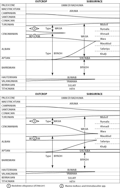
Click on the image to enlarge it.
Plate IV. Cretaceous outcrop - subsurface correlations.
Cretaceous (Turonian) |
Obsolete name, synonymous with Mishrif Member. See: Mishrif Member.
Cretaceous (Hauterivian) |
Author.- R.A. , 1951; unpublished report. Amended by C.D. , 1962; unpublished report.
Synonymy. - 'Buwaib Formation', and others, 1966 (formal definition of amended section).
Type section.- Measured in the face of Jal Buwayb at lat. 25°15'03"N, long. 46°38'52"E. One of the most complete sequences of Buwaib rocks occurs a few kilometers north of Khafs Daghrah (lat. 23°50'N) and this has been designated a reference locality ( and others, 1966).
Reference section details:
Location: On a continuous traverse from lat. 23°53'51"N, long. 47°18'53"E to lat. 23°53'52"N, long. 47°19'53"E.
Thickness: 17.7 meters.
Lithology: Shale, dolomite, calcarenite, and aphanitic limestone, complexly interbedded; occasional very thin beds of quartz sandstone.
Fossils: Everticyclammina greigi (), Everticyclammina hensoni and other lituolids.
Age: Lower Cretaceous (Hauterivian) on contained fossils and stratigraphic position.
Underlying Formation: Yamama Formation; contact unconformable, placed at change from tan aphanitic limestone above to golden-brown calcarenite below.
Overlying Formation: Biyadh Sandstone; conformable and gradational from sandy dolomite and calcarenite below to black-weathering sandstone above.
Other localities.- Outcrops of the Buwaib Formation have been mapped in a narrow, irregular band from Khashm al Bazum (lat. 20°38'N) to the northern end of Jal Buwayb (lat. 25°24'N), a distance of nearly 600 kilometers.
Remarks.- Recent work has shown that some modification of the type Buwaib as defined by and others (1958) was necessary. It can be demonstrated that the lower two-thirds of the 33.8 meter interval previously assigned to the type Buwaib is, in fact, equivalent to the lower part of the type Yamama and, in addition, falls below the pre-Buwaib unconformity. Supporting evidence is cited as part of the discussion on the Yamama Formation, which see.
Based on the new data, it was logical to restrict the name Buwaib Formation to the upper 11.2 meters of the type section at Khashm Buwayb and throw the lower 22.6 meters with the Yamama. With these changes, the Buwaib takes in all beds carrying Everticyclammina greigi. The base of the formation everywhere falls at the stratigraphic break that has been called the 'pre-Buwaib unconformity' both in surface and subsurface reports.
The general lithologic character of the Buwaib Formation changes but little along the length of outcrop. Aphanitic limestone and calcarenitic limestone are most common but invariably the sequence is broken with thin intervals of calcarenite, sandstone and shale. Beds of clean quartzose sandstone appear to be confined to the upper part of the formation.
In the type area the Buwaib Formation as presently restricted is approximately 11 meters thick. At Ma'aqala and Khurais the thickness increases to about 60 and 100 meters respectively but in both instances the general lithologic character and sequence of the formation remains much as it was on outcrop and consists largely of limestone with a few beds of sandstone in the upper part and rare streaks of shale near the base.
To the east, in Ghawar field and over coastal Arabia, the upper part of the Buwaib Formation carries a much greater proportion of shale. This part of the formation was in fact for many years included within and formed the lowermost beds of the 'Greenish gray shale' (obsolete).
Underlying the upper shaly interval in most of the eastern area is a thin bed of compact, relatively pure aphanitic limestone which carries Chrysalidina arabica () and a fairly common high-spired Trocholina. This bed equates to the 'Valvulinella zone' (obsolete) of longtime Aramco usage. It is now formally referred to as the Chrysalidina zone (a reversion to a name employed first in Bahrain in 1937). Though it loses its distinctive faunal and lithologic character in the southern part of Ghawar field it is otherwise widely distributed in the Eastern Province and forms a very useful marker.
The section immediately below the Chrysalidina zone consists of interbedded limestone and shale. This interval, as yet unnamed, is underlain by the massive limestone beds of the mid-Thamama limestone, the upper part of which forms the basal member of the Buwaib Formation.
Altogether, the total thickness of Buwaib in its eastern facies varies from a minimum of approximately 55 meters at Dammam field to a maximum of nearly 115 meters at 'Uthmaniyah.
Both in the type area and in nearby wells developing similar lithologies the top of the Buwaib is picked at the top of the first marine limestone underlying the Biyadh sand. Everticyclammina greigi () is abundant in the upper part of the formation and usually appears shortly below the top of the limestone. To the east, even though limestone beds may be present at the top of the Buwaib, E. greigi does not appear in any quantity until near the middle of the Buwaib. Whatever the controlling factor, it is evident that in this area the uppermost beds of the Buwaib did not present a favorable environment for E. greigi. 'Daxia' sp. does appear in these beds, however, and the present supposition is that this form may be used in place of E. greigi as an indication of a stratigraphic position within the uppermost part of the Buwaib.
There is good evidence of angular discordance at the base of the Buwaib Formation on outcrop and at well ST-11, Ma'aqala and Khurais field as well as probable loss of section at Jauf. Elsewhere in coastal Arabia though, the Buwaib appears to overlie the Yamama Formation with complete conformity. Such conformity does not alter the fact that the Buwaib Formation is a distinct faunal and lithologic entity - one that can be split off from underlying beds by: (a) disappearance of E. greigi and appearance of E. eccentrica which are confined to the Buwaib and uppermost beds of Yamama Formation respectively; (b) change from white to gray compact aphanitic limestone with streaks of greenish-gray shale above to tan, more porous limestone below; and (c) electric log signature pattern.
Since the Buwaib unconformably overlies the Valanginian Yamama Formation along the outcrop and underlies the lowermost occurrences of Orbitolina cf. O. discoidea , O. discoidea var. delicata and Choffatella decipiens in subsurface, its most probable position would be within the Hauterivian.
For development of Buwaib nomenclature see Thamama Group.
(Remarks in part after C.D. , 1962; unpublished report).
?Cretaceous (Cenomanian) |
Informal name, applied to lower of two lithologic units that comprise the Ahmadi Member of the Wasia Formation. The Caprock limestone, recognized from Fadhili field north, is thickest at the north end of Safaniya where it becomes porous and oil-bearing (= Ahmadi reservoir).
See: Ahmadi Member.
Eocene (Lower Eocene) |
Obsolete name, first used in 1935 by S.B. and J.W. (unpublished report) for sequence of chalky limestone exposed in Umm ar Ru'us (lat. 26°19'N, long. 50°08'E). Synonymous with Rus Formation, which see.
Cretaceous (Hauterivian) |
Term originally applied in 1937 in unpublished Bahrain report to thin layer of relatively clean limestone which bears a restricted and distinctive foraminifer and provides highly reliable correlation (near the middle of what is now the Buwaib Formation) over most of northeastern Arabia. It was redesignated as 'Valvulinella zone' in 1939; a term used consistently in company reports until 1962 when C.D. (unpublished report) reverted to the original name.
In the Eastern Province and adjacent offshore area, the top of the zone is picked on lithology and is confirmed by faunal evidence; the actual top is placed at the point where buff, compact, aphanitic limestone appears below the normal shale or impure limestone of the upper Buwaib; it is confirmed by the presence of either Chrysalidina arabica () or Cyclammina sp. in close proximity to the lithologic top. Poorly preserved, high-spired Trocholinas are sometimes common at this level, and the limestone itself is often traversed by numerous, irregular veinlets of crystalline calcite.
The zone is typically developed in the northern end of 'Uthmaniyah and northward, but to the south, loses most of its faunal and lithologic identity. At Haradh the Chrysalidina zone is completely unrecognizable as such and its approximate level can only be established by indirect means.
In the predominately limestone section of the western area - well ST-11 (lat. 26°23'N, long. 46°20' E), Ma'aqala, Khurais - the Chrysalidina zone loses its distinctive lithology but is still identifiable on faunal grounds. C. arabica is often absent in this facies but Cyclammina sp. which appears to have exactly the same range, is usually present.
See: Buwaib Formation.
(In part from C.D. , 1962; unpublished report).
Cretaceous (Albian-Cenomanian) |
Informal name, first used by C.D. in 1962 (unpublished report) to set off interval within Wasia Formation characterized throughout by Crusella intermedia and including Ammobaculites sp., Trocholina lenticularis var. minima and numerous Ostracod species in the upper part and Ammobaculites sp., Hemicyclammina whitei (), and Orbitolina concava () var. qatarica in the lower part.
The following lithologic subdivisions fall in whole or in part within the Crusella intermedia zone in Safaniya field:
| Ahmadi Member (part) | |
| This member contains the Vulvulina shale unit at the top and the Caprock limestone unit at the bottom. The top of the Crusella intermedia zone falls within the lower part of the Vulvulina shale interval. | |
| Wara Member | |
| Mauddud Member | |
| Safaniya Member (part) | |
| The Crusella intermedia zone includes at least the uppermost shale unit of this member. | |
The precise lower limits of the zone have not yet been established but such forms as C. intermedia and H. whitei are known to range below the base of the Mauddud Member. Microfaunas from the portion of the Wasia below the upper part of the Safaniya Member, although little known, do not appear to include any of the more typical species of the Crusella intermedia zone. This same interval, however, is known to contain spore and pollen assemblages differing from those of the Crusella intermedia zone and with elements in common with assemblages from the underlying Biyadh Formation. Consequently, the upper shale unit of the Safaniya Member is accepted tentatively as the basal part of the Crusella intermedia zone.
(In part from C.D. , 1962; unpublished report).
Miocene (Middle Miocene) |
Authors.- M. and T.W. , 1935; unpublished report.
Remarks.- The Dam Formation is named for Jabal al Lidam (lat. 26°21'42"N, long. 49°27'42"E) where the lower part of the type unit crops out. Lower beds of the formation were measured in the east face of Jabal al Lidam and the upper part of the 89.8 meter interval at Al Umayghir (lat. 26°17'15"N, long. 49°30'24"E).
At the type locality, the base of the Dam is placed at the change from sandstone of the Hadrukh below to fossiliferous marl with Echinocyamus above. The top is at the contact between marl and limestone with marine fossils below and clay, sandstone and gravel of the basal Hofuf Formation above.
Residual patches of Dam rocks show that the middle Miocene sea transgressed roughly 120 kilometers inland from the modern coastline and covered an extensive area from south of Qatar to the eastern edge and around the northern end of Ghawar and then on to Jibal an Nu'ayriyah (lat. 27°31'N, long. 48°23'E). This is a distance of about 450 kilometers measured parallel to the coast. Around the margins, marine rocks of the Dam give way rapidly to continental deposits with complete gradation often taking place in as short a distance as 10 kilometers.
Thickness of the Dam Formation varies considerably. About 90 meters is exposed at the type locality but elsewhere as little as 30 meters and as much as 100 meters have been found to represent a full section.
The Dam Formation is pink, white and gray marl, and red, green, olive clay with minor interbeds of sandstone, chalky limestone and coquina. Marine fossils are abundant throughout the unit but the best marker zones are near the base. One of these is composed of large numbers of small echinoids Echinocyamus sp. and the closely associated 'Archaias' sp. bed, are undoubtedly the most widespread. It has been recognized throughout the area of Dam outcrop.
The presence of Ostrea latimarginata , Echinocyamus sp. and 'Archaias' sp. indicates approximate correlation with the lower Fars Formation of Iraq and on this basis, the Dam is presumed to be about middle Miocene in age.
Eocene (Lower-Middle Eocene) |
Author.- R.A. , 1941; unpublished report.
Synonymy.- 'Dammam formation', and , 1956 (first published reference); 'Dammam formation', and others, 1958 (formal definition); 'Dammam formation', and , 1958; 'Dammam formation', and others, 1959; 'formation de Dammam', , 1962; 'Dammam Formation', and others, 1966.
Type section details:
Location: Along Dhahran-Al'Alah road from where this road intersects the rimrock (lat. 26°19'16"N, long. 50°04'50"E) northwest to the Eocene-Miocene contact.
Thickness: 32.5 meters.
Lithology: Limestone, tan to light brown with interbeds of marl in upper part and shale in lower.
Fossils: Alveolina cf. A. decipiens , A. eliptica () var. flosculina , and Nummulites spp.
Age: Lower and Middle Eocene (Ypresian-Lutetian).
Underlying Formation: Rus Formation; contact conformable, taken at sharp change from brown shale above to chalky calcarenite below.
Overlying Formation: Hadrukh Formation; contact unconformable, marked by clean limestone below and sandy limestone above.
Other localities.- Dammam beds crop out in a narrow, irregular band from Wadi as Sahba to latitude 25°41'N, a distance of nearly 180 kilometers. A full Dammam sequence is exposed in the conspicuous oval-shaped escarpment rimming Dammam Dome. Four small outliers of Dammam have been mapped generally west of the dome and north of Abqaiq and another near Harad (lat. 24°08'N, long. 49°04'E).
A relatively large exposure of Dammam, about 20 square kilometers, occurs at the base of the Qatar Peninsula.
Numerous isolated exposures of Dammam and Rus and Dammam undivided along the eastern and southeastern margin of the Rub' al-Khali show that Eocene rocks floor a substantial area beneath eolian sand cover.
The Dammam is widely represented in the subsurface where it has been penetrated in numerous wells throughout the Rub' al-Khali, Eastern Province, and Arabian Gulf areas.
Remarks.- The Dammam Formation is defined to include a widely recognized and quite distinctive succession of shallow water normal marine sediments. Where present in full thickness, the Dammam is almost everywhere divisible into five members, two of which possess distinctive and laterally persistent basal marl units. Listed in descending order, these members and their subdivisions are as follows:
| Alat Member | |
| Alat limestone | |
| Alat marl | |
| Khobar Member | |
| Khobar dolomite | |
| Khobar marl | |
| Alveolina Limestone Member | |
| Saila Shale Member | |
| Midra Shale Member | |
The Alat Member takes its name from Al Alat well 1 (lat. 26°27'49"N, long. 49°50'11"E), where the upper part of the member is exposed nearby and the lower part is represented by the drilled interval from 0 to 67 meters. Alat beds are best displayed in a low hill at latitude 26°19'42"N, longitude 50°08'24"E, and this section has been designated as the type locality.
Here, as elsewhere, the upper part of the member is limestone (6.0 meters), the lower part, marl (6.0 meters). The lower marl was form any years informally referred to as the 'Orange marl', but the name is now obsolete. The top of the Alat is at the unconformable contact (pre-Neogene unconformity) of light-colored, chalky dolomitic limestone below with sandy limestone of the Hadrukh Formation above. The base is taken at the break from dolomitic marl above to dolomite or dolomitic limestone (with abundant Nummulites) of the Khobar Member below.
The Alat limestone in the subsurface is mostly light colored, porous, generally dolomitic limestone with abundant molds and casts of mollusks. This part of the section is usually barren of foraminifera, but the higher beds carry occasional specimens of a very large Dictyoconus. Whatever portion of the Alat limestone underlies the pre-Neogene unconformity often shows local silicification near the contact.
The basal marl unit, usually 15 to 18 meters thick, is fine-grained marl, in part with abundant but discrete dolomite rhombs. In El Alat well 1, where the marl contains a considerable percentage of clay, the colors in this unit are gray, tan and brown. Elsewhere the marl is limonite stained and varies from a creamy yellow to a definite orange. A very few poorly preserved foraminifera have been seen in the lower part of the marl. Identification can not be carried below the generic level, but the fauna appear to be much as in the underlying Khobar dolomite.
Pre-Alat members of the Dammam Formation are exposed at several places along the rim rock of Dammam Dome but one of the best sections is that southwest of Umm ar Ru'us at lat. 26°16'10"N, longitude 50°06'26"E. This sequence has been designated as the type locality for the Khobar, Alveolina, Saila, and Midra Members.
The Khobar Member is named for the town of Al Khubar (lat. 26°17'N, long. 50°13'E) on the eastern edge of the Dammam Dome rimrock. Characteristically, the upper part of the unit is limestone and the lower part marl; at the type section, thicknesses are 7.8 and 1.5 meters respectively. The top of the member is placed at the contact of Nummulites-bearing dolomitic limestone or dolomite below with marl of the Alat Member above. The base falls at the change from Nummulitic marl above to Alveolina-bearing limestone below.
The name 'Khobar dolomite (and limestone) member' was originally proposed to differentiate the upper limestone unit in well sections but usage has reduced this to 'Khobar dolomite' in spite of the fact that limestone and marl are far more typical of this part of the section. There are some instances where dolomite predominates, but this is unusual.
The top of the Khobar dolomite is defined in subsurface - as it is on the surface - by a change from marl above to limestone ordolomite below. It is confirmed by the presence of Asterigerina sp., Coskinolina balsilliei , Dictyoconoides cooki (), Halkyardia chapmani (), Linderina brugesi , L. buranensis & , L. sp., Nummulites somaliensis & form A, N. somaliensis & form B, N. sp. and Rotalia sp.
Many of these forms range from top to bottom of the Khobar dolomite and a number range on down at least to the top of the Alveolina Member.
In coastal Arabia the limestone and dolomite which predominates in the Khobar dolomite are underlain by a cream-colored to light gray marl ranging in thickness from 2 meters on Dammam Dome to 18 meters at Abu Hadriya. The Khobar marl carries abundant microfossils differing in part from those in the overlying Khobar dolomite. The faunal break does not coincide with the lithology break, however, but falls up to 5 meters above the top of the marl. There appears to be up to 3 meters of variation in the stratigraphic position of the top of the Khobar marl but it always falls below the level of the highest Nummulites beaumonti form A.
The Khobar marl is very thin throughout Ghawar field, probably nowhere more than 3 meters thick. Its top is established on lithologic grounds, as in coastal Arabia, but it is only at Ain Dar and Fazran that an underlying Alveolina Limestone can be recognized. Further south along Ghawar field the Alveolina Member becomes progressively thinner, and ultimately disappears, either by loss of lithologic identity or by overlap at the base of the Khobar marl. Whichever the cause, the limestone ceases to be distinguishable. It is still possible, however, to pick a point corresponding very closely to the base of the Khobar marl on the basis of a change from cream or light-gray marl above to blue or blue-gray marly shale below.
The Alveolina Limestone Member, only 1.0 meters thick at the type section, characteristically contains common specimens of Alveolina elliptica var. flosculina. The top of the member is picked on a lithologic break from marl to limestone and is confirmed by fauna. The base is placed at the level where tan Alveolina-bearing limestone gives way downward to blue and gray-blue shale or marl of the Saila Shale. In the subsurface, the member consists of tan, soft, porous limestone, characteristically with common specimens of either A. elliptica var. floscula or Dictyoconoides sp. Thicknesses vary from probably 0 meters at the southern end of Ghawar field to 12 meters at Abu Hadriya.
The top of the Alveolina Limestone is picked on lithology and is confirmed by fauna. Both Dictyoconoides sp. and Linderina cf. L. paronai appear for the first time at the top of this member. A. elliptica var. floscula usually becomes common at or near the top, but this species also occurs sporadically on up through the Khobar marl into the basal part of the Khobar dolomite.
The base of the Alveolina Limestone is placed at the level where tan Alveolina-bearing limestone gives way downward to gray or blue marl.
At the type locality the Saila Shale Member consists of 3.6 meters of brownish-yellow, subfissile clay shale underlain by 0.6 meters of gray limestone. In well sections, the upper part of the Saila Shale is blue to blue-gray in color and often pyritic. Wells in coastal Arabia show up to 14 meters of this member, usually with a thin Nummulites globulus -bearing limestone at the base. A comparable thickness of Saila Shale is present in the region west of Fazran but the interval is much reduced in Ghawar field wells.
Where the Alveolina Limestone Member is not represented in typical lithology, such as southern Ghawar and in the Rub' al-Khali, the top of the Saila Shale is picked at the level where varicolored marl gives way downward to blue or blue-gray marl or shale. The color break is sharp.
The basal member of the Dammam Formation - the Midra Shale (originally 'Shark Tooth shale', informal and obsolete) - is 3.0 meters thick at the type section. The top half is largely yellow-brown earthy clay shale, and the bottom half mainly light-gray marl and soft, impure limestone.
Deep well occurrences of this member closely resemble the surface exposures, but the thickness increases up to a maximum of 8 meters. Nummulites aff. N. lucasana () occurs in the Midra Shale and may be limited to it. N. globulus also occurs at this level but is definitely known to range up into the Saila Shale.
The top of the Midra Shale is picked solely on lithology. It is placed at the uppermost occurrence of yellow-brown, earthy clay shale below the limestone and blue to blue-gray (rarely brown) marl or shale of the Saila Shale Member. The lithologic distinction between the Midra and Saila Members is vague in the region between 'Uthmaniyah and Hawiyah and is completely gone at Haradh and in Rub' al-Khali wells.
The lower limit of the Midra Shale (= base of Dammam Formation) is everywhere marked by a sharp but conformable change from fossiliferous, earthy brown shale or impure limestone above to barren, light-colored, chalky limestone or marl of the Rus Formation below.
At the type locality the Dammam Formation as a whole is only about 28 meters thick. Off this structure, however, the formation rapidly thickens to more than 120 meters in nearby Qatif field and up to 192 meters on the flanks of Abu Hadriya field. Part of this increase is doubtless caused by the inclusion of stratigraphically higher beds beneath the pre-Neogene unconformity, but the major portion is caused by thickening of the individual members within the formation.
From the uppermost beds of the Alat Member, which carry a very large Dictyoconus sp., to the base of the Alveolina Limestone with Alveolina elliptica () var. flosculina , the Dammam Formation is clearly Middle Eocene (Lutetian) in age. Below this level the presence of a 'Nummulites globulus ' of the type figured by (1954) from the Lower Eocene of Qatar gives a strong possibility that the remainder of the formation is Lower Eocene (Ypresian).
(In part from C.D. , 1962; unpublished report).
Jurassic (?Lower Bathonian) |
Informal term first used by E.L. and others in 1945 (unpublished report) to embrace massive, cliff-forming limestone that supports Khashm adh Dhibi. Also referred to by and in (1952), and others (1958), and and others (1966) as upper unit of lower Dhruma which should be referred to for details; synonymous with Ermoceras zone of surface and Haurania zone of subsurface.
See: Dhruma Formation.
Jurassic (Bajocian - ?Callovian) |
Author.- M. , 1937; unpublished report.
Synonymy.- 'Dhruma member', 1937-45 (unpublished reports); 'Dhruma formation', and in , 1952 (first formal definition); 'Dhruma formation', and , 1956 and 1957; 'Dhruma formation', and others, 1958; 'Dhruma Formation', and others, 1966.
Type section.- Type sequence composited from successive measurements at Khashm adh Dhibi (lat. 24°12'24"N, long. 46°07'30"E) and between Khashm adh Dhibi and Khashm al Mazru'i (lat. 24°19'00"N, long. 46°19'36"E). A more complete Dhruma succession, pieced together in the same general area as the type locality, was designated a reference section by and others (1966).
Reference section details:
Location: Khashm adh Dhibi. A complete succession was composited from three increments: (1) the lower 120.8 m was measured in the face of the Dhibi escarpment between lat. 24°11'17"N, long. 46°11'10"E and lat. 24°11'53"N, long. 46°11'30"E; (2) the middle 63.7 meters on the back slope of the Dhibi limestone between lat. 24°11'04"N, long. 46'17'14"E and lat. 24°11'12"N, long. 46°17'17"E; and (3) the upper 190.0 meters in the face of the Tuwaiq Mountain Limestone scarp between lat. 24°11'19"N, long. 46°18'50"E and lat. 24°12'34"N, long. 46°19'03"E.
Thickness: 374.5 meters.
Lithology: Reference sequence subdivided on the basis of lithology and contained ammonite faunas. Units - both formal and informal - are from bottom to top:
Lower Dhruma (120.8 meters)
- 30.5 meters shale, green and purple, gypsiferous with thin interbeds of aphanitic limestone and calcarenite; well bedded gypsum at base (Dorsetensia zone).
- 35.6 meters shale, green to brown, gypsiferous, interbedded with calcarenitic limestone.
- 20.2 meters shale, olive-green, gypsiferous.
- 34.5 meters: lower part is olive-green, gypsiferous shale; middle part is unexposed; upper part is cliff-forming lithographic limestone = Dhibi limestone member (Ermoceras zone).
Middle Dhruma (164.7 meters)
- 42.3 meters calcarenite and calcarenitic limestone interbedded (Thambites zone).
- 36.1 meters calcarenitic limestone, golden-brown, pellet-oolite-molluscan, interbedded with pellet calcarenite and aphanitic limestone (Tulites zone).
- 32.3 meters: lower part is brown aphanitic limestone; middle interval is covered; upper beds are cross-bedded, oolite-foraminiferal-molluscan calcarenite (Micromphalites zone).
- 54.0 meters aphanitic limestone interbedded with brown, pellet-molluscan-algal calcarenitic limestone (Dhrumaites zone).
Upper Dhruma (89.0 meters)
- 25.0 meters calcarenitic limestone, pellet-molluscan-algal; several interbeds of aphanatic limestone and a few layers of oolite-detrital calcarenite ('Atash Member).
- 64.0 meters shale, tan to olive-tan, calcareous; thin interbeds of calcarenite, calcarenitic limestone and aphanitic limestone (Hisyan Member).
Fossils: Unit 1 - Dorsetensia arabica . Unit 4 - Eligmus polytypus (), E. rollandi , Eudesia cardium (), Lopha solitaria (J. de C. ), Ermoceras aulacostephanus , E. coronatoides (H. ), E. elegans H. , E. aff. E. mogharense H. , E. magnificum , E. reineckeoides , E. runcinatum , E. splendens , E. strigatum , Stephanoceras arabicum , Thambocerasmirabile , Dhrumella evoluta , Haurania amiji , H. deserta , Nautiloculina spp., Pfenderina inflata , Pseudomarssonella primitiva , and Riyadhella elongata . Unit 5 - Chlamys curvivarians , Eligmus polytypus (), E. rollandi , E. rollandi var. jabbockensis , Eudesia cardium (), Homomya cf. H. gibbosa (J. ), Thambites planus , Dhrumella evoluta , Nautiloculina spp., Pfenderina sp., Pseudomarssonella mcclurei , P. primitiva , and Riyadhella elongata . Unit 6 - Arcomytilus somaliensis , Chlamys curvivarians , Eligmus rollandi , Homomya cf. H. gibbosa (J. ), Modiolus (Inoperna) plicatus (J. ), Pholadomya lirata (J. ), Tulites arabicus , T. erymnoides , T. tuwaiqensis , Dhrumella evoluta , Nautiloculina spp., Pseudomarssonella reflexa , Riyadhella elongata , R. riyadhensis , and Virgulina spp. Unit 7 - Bakewellia waltoni (), Daghanirhynchia daghaniensis , Eligmus rollandi , Gryphaea costellata , Homomya cf. H. gibbosa (J. ), Lophasolitaria (J. de C. ), Micromphalites elegans , M. pustuliferus (H. ), M. vertebralis , M. cf. M. busqueti (de ), Pholadomyalirata (J. ), Dhrumellaevoluta , Nautiloculina spp., Pseudomarssonella reflexa , Riyadhella elongata , R. riyadhensis , and Virgulina spp. Unit 8 - Dhrumaites cardioceratoides , Flabellammina sp. Nautiloculina spp., Pseudomarssonella biangulata , P. bipartita , Riyadhella inflata , R. nana and R. rotundata . Unit 9 - Eligmus rollandi , E. rollandi var. jabbockensis , Eudesia cardium (), E. cardioides , Gryphaea costellata , Homomya inornata (J. de C. ), Mactromya aequalis , Pholadomya aubryi , P. lirata (J. ), 'Terebratula' cf. superstes , Kurnubia variabilis , Nautiloculina spp., Pfenderella arabica , Pfenderina gracilis , P. trochoidea & , P. neocomiensis & , Pseudomarssonella maxima , P. plicata , Sanderella laynei , and Trocholina spp. Unit 10 - Gryphaea costellata , Conicospirillina sp., Kurnubia bramkampi , K. spp., Praekurnubia crusei , Pseudomarssonella media , Riyadhella hemeri , R. sp. Steinekella crusei , Trocholina palastiniensis , and T. cf. T. palastiniensis .
Age: Middle - ?Upper Jurassic (Bajocian - ?Callovian) on contained fossils.
Underlying Formation: Marrat Formation; contact presumed conformable, placed at change from gypsum with interbeds of shale and limestone above to cliff-forming limestone below.
Overlying Formation: Tuwaiq Mountain Limestone; contact disconformable, taken at change from olive-green shale below to soft, chalky limestone with interbedded shale above.
Other localities.- At the surface, beds of the Dhruma Formation form a broad arc extending from Al 'Arid (near latitude 19°20'N) to 'Irq al Mazhur (near lat. 27°05'N), a distance of more than 900 kilometers. The formation has also been partially or completely penetrated in bore holes drilled: in and near Ad Dahna sand belt; along the southern margin and in the central part of the Rub' al-Khali; at Jauf; and in most oil fields.
Remarks.- The Dhruma Formation accommodates a thick sequence of shallow-water limestone and marine shale that crops out a short distance west of the capital city of Ar Riyad (Riyadh). (See Tuwaiq Formation for development of Dhruma Formation and related nomenclature.)
Published discussions have split the surface sequence into three main lithologic units designated informally as: (1) upper Dhruma comprising two formally defined members - the Hisyan above and the 'Atash below; (2) middle Dhruma containing the informal ammonite zones Dhrumaites, Micromphalites, Tulites, and Thambites; and (3) lower Dhruma with the Ermoceras zone at the top, the Dorsetensia zone at the base and an unnamed interval in between ( and in , 1952; and others, 1958; and others, 1966).
The basic outcrop pattern between Wadi al Hawtah (lat. 23°33'N) and Ar Raghbah (lat. 25°09'N) is: lower Dhruma - shale with some limestone, in vicinity of Khashm adh Dhibi bedded gypsum occurs at base, capping unit is massive, cliff-forming Dhibi limestone member; middle Dhruma - limestone, beds of clean calcarenite occur at various levels often as units with high lateral persistence, upper oolite bed forms prominent cliff; upper Dhruma - carbonate in lower part, shale in upper.
The most obvious lateral change in the surface sequence is the southward replacement of limestone and shale by sandstone. The first to go is the lower Dhruma which becomes dominantly sandstone in the vicinity of Khasham al Khalta' (lat. 23°35'N); the middle and upper members give way to sandstone near Al Haddar (lat. 22°00'N). Change from limestone to sandstone takes place abruptly in individual beds, usually without passing through a shaly phase and represents transition from marine to continental deposition. Northward, beyond Ar Raghbah, the proportion of shale gradually increases until it dominates the sequence at Al Jurayfah (lat. 25°31'N). Some thin beds of sandstone also occur here; progressively more are added to the north establishing a definite trend toward shoreline conditions.
Several distinct facies of the Dhruma Formation are also evident in the subsurface. In the central Rub' al-Khali nearly complete, albeit condensed, 150-meter thick Dhruma sequences are mainly clean carbonate. Light-colored, quiet-water aphanitic and calcarenitic limestones predominate; however, substantial amounts of clean-washed calcarenite occur at Al 'Ubaylah. Over much of northeastern Arabia (Ar Riyad, Khurais, Ghawar, Ab-qaiq, Dammam, Fadhili, Umm al Jamajim, etc.) shelf limestone, mostly aphanitic and locally dark-colored and argillaceous predominates; calcarenitic limestone and shale is interbedded in varying proportions. Although essentially full Dhruma successions are present throughout the area, those on the west are substantially thicker, falling between 500 and 535 meters. In contrast, coastal intervals are roughly 320 meters thick. In extreme northeastern Arabia - that is, at Jauf and Safaniya - more-basinal sedimentation is indicated as the Dhruma is largely dark-colored, impure limestone. Gray and black shale is commonly interbedded and some anhydrite layers appear in the lower part of the section. The Dhruma sequences at Jauf and Safaniya differ markedly from all others in that only the pre-Dhibi (pre-Ermoceras) or lower part of the formation is represented; the middle and upper Dhruma have been truncated. So far as thickness is concerned, however, expansion more than offsets the massive erosion and pre-Dhibi beds reach a thickness of nearly 700 meters in both areas.
The lower boundary of the Dhruma Formation is apparently conformable in the Ar Riyad-Khurais-central outcrop area; elsewhere basal beds roughly corresponding to the Dorsetensia zone are missing and the contact is a marked unconformity of regional extent. Usually the Marrat Formation is the underlying unit but in the southern area of outcrop, in wells along the southern edge of the Rub' al-Khali and at Safaniya, the Dhruma rests on various Permo-Triassic units.
The upper Dhruma surface is also an unconformity. Truncation is slight, almost everywhere involving Tuwaiq Mountain Limestone resting on the gently eroded surface of the Hisyan Member. At Jauf and Safaniya, however, all but the pre-Dhibi part of the formation has been removed and the lower Dhruma in these two areas is overlain respectively by the Tuwaiq Mountain and Hanifa Formations. In the south, the Dhruma, overlapped by the Tuwaiq Mountain Limestone, wedges out on a line roughly corresponding to the southern limit of Rub' al-Khali sand.
A number of distinctive microfaunal zones and several intervals with highly characteristic lithologies accurately fix in well sections equivalents of the upper, middle and lower Dhruma surface units. Neither the foraminifera zones nor the ammonite zones of (1952) have formal stratigraphic status in this or other reports; however, they have, through continued usage, gained some semblance of stratigraphic validity and recognition. Hence, they are referred to here for convenience and to tie the discussion to other work, published and unpublished.
Upper Dhruma.- The term Hisyan Member has been applied to the shale and/or impure limestone interval which forms the upper part of the upper Dhruma over most of the outcrop area and in numerous wells to the east. The upper limit of the Hisyan Member (= top Dhruma Formation) is placed immediately above the uppermost occurrence of Kurnubia bramkampi where soft limestone and shale of the Tuwaiq Mountain Limestone is in contact with Hisyan sediments. Regional variations clearly indicate the contact is unconformable but faunas above and below the line have enough elements in common to suggest that no important time break is involved. The lower boundary of the member is placed at the uppermost calcarenite limestone of the 'Atash Member.
Thickness of the Hisyan Member, about 47 meters at the type locality, increases to roughly 80 meters in the Ar Riyad-Khurais area and reaches a maximum of 145 meters at Umm al Jamajim. Marked thinning to an average of about 20 meters is evident in the vicinity of El Haba, coastal wells and at Al 'Ubaylah.
The Hisyan is split into two microfaunal zones; the Kurnubia bramkampi zone above, the Praekurnubia crusei zone below. The upper zone is about 12 meters thick at the surface, increasing to between 40 and 50 meters in well sections; the lower zone, bearing the diagnostic and stratigraphically stable P. crusei, is roughly 35 meters thick on outcrop which is in fairly close agreement with thicknesses at Ar Riyad and Khurais. The zone has not yet been traced into coastal or Rub' al-Khali wells.
The 'Atash Member applies to the dominantly chalky calcarenitic limestone interval that forms the basal part of the upper Dhruma at Khashm al 'Atash, throughout most of the outcrop area and in numerous well sections. The top is taken at the base of the Hisyan Member; the base is placed at the contact with gray, impure calcarenitic limestone and/or shale of the underlying middle Dhruma.
The member is about 40 meters thick at Umm al Jamajim and Fadhili; similar thicknesses prevail southeast as far as the central Rub' al-Khali. Well sections in the vicinity of Ath Thumami and El Haba (Al Lihabah), however, are somewhat more than twice as thick.
The 'Atash Member contains two microfaunal zones. The top of the upper zone, the 'Pseudocyclammina' zone, coincides with the top of the member; the base of the lower zone, the Pfenderina trochoidea zone, coincides with the base of the member. Both zones fall within the porous interval of the lower Fadhili oil reservoir of deep wells and it is evident that the 'Atash Member is the exact stratigraphic equivalent of this important producing interval. Of the two microfaunal zones in the 'Atash, the 'Pseudocyclammina' zone exhibits the most variation in thickness with the Pfenderina trochoidea zone ranging only from a minimum of 16 meters at Khashm al 'Atash to a maximum of 20 meters at Fadhili.
(1952) listed such forms as Gryphaea costellata , Eligmus rollandi , Eligmus rollandi var. jabbokensis , Eudesia cardium and Eudesia cardioides from the upper Dhruma and assigned a questioned Upper Bathonian age to it. However, the rich foraminiferal faunas in the upper part of the Hisyan Member are so closely related to those of the immediately overlying Middle Callovian lower portion of the Tuwaiq Mountain Formation as to suggest a break of less than stage magnitude at the contact. This is particularly true of the highly evolved and closely related Kurnubias occurring on both sides of the line. In view of these relationship it seems reasonable to suspect that at least the upper part of the Hisyan Member will prove to be no older than Callovian.
Middle Dhruma.- The middle Dhruma surface sequence contains four ammonite zones (, 1952). In descending order these are: Dhrumaites zone, Micromphalites zone, Tulites zone, and Thambites zone. Three distinct microfaunal zones have also been recognized; from the top down these are: Flabellammina zone, Dhrumella evoluta zone and Pseudomarssonella mcclurei zone. It is known that Dhrumaites occurs in the Flabellammina zone and Thambites in the P. mcclurei zone. Also, general thickness relationships suggest that Tulites would fall in the D. evoluta zone and Micromphalites within the lower part of the Flabellammina interval. It is not known to what extent the foraminiferal zones and the ammonite zones are coextensive.
At the surface the middle Dhruma is mainly soft, light-colored aphanitic and calcarenitic limestone with common beds of clean-washed calcarenite. In equivalent subsurface sections soft, fine-grained limestones still prevail but many are darker colored and argillaceous. Beds of marl and marly shale are common as are layers of muddy, often impure calcarenitic limestone; clean-washed calcarenite is rare to absent.
Total thickness of the middle Dhruma in the vicinity of Khashm adh Dhibi is 170 meters, at Ar Riyad 218 meters and at Khurais 224 meters. Other subsurface intervals north of the latitude of Ar Riyad vary little from an average of 180 meters except at Jauf and Safaniya where equivalent beds are truncated.
The top of the middle Dhruma is taken at the contact between calcarenitic limestone of the 'Atash Member above and gray, argillaceous calcarenitic limestone or shale carrying Flabellammina or Riyadhella rotundata below. The base is placed at a change from soft gray marl and marly shale of the P. mcclurei zone above to tight, white to cream aphanitic limestone of the Dhibi Member below.
(1952) gives the following age references to the succession of middle Dhruma ammonite faunas:
| Top | |||
| Dhrumaites fauna | Middle (and Upper ?) Bathonian |
||
| Micromphalites fauna | |||
| Tulites fauna | |||
| Thambites fauna | Lower Bathonian ? | ||
Lower Dhruma.- The lower Dhruma is 127 meters thick in the type area. Both in surface and subsurface sections its uppermost member - the Dhibi limestone - consists of cream-colored lithographic limestone passing downward into softer, partly calcarenitic limestone with interbedded shale. The Dhibi Member (Ermoceras zone of , 1952) carries the distinctive microfaunas of the Haurania zone which have been traced eastward to Ar Riyad, Khurais, 'Uthmaniyah, Shedgum, Abqaiq and Damman and north as far as Fadhili. Dhibi (Haurania zone) thickness is remarkably constant varying little from 30 meters. The Dhibi limestone was assigned a Bajocian age by (1952) on the basis of the Ermoceras fauna collected from beds thought either to represent the Dhibi or to be laterally equivalent to it. According to C.D. , however, (1965, unpublished report):
'That some ... error exists in the original dating of the Dhibi Limestone Member is suggested by the fact a number of the genera and species of foraminifera which are found within the Dhibi range upward into the overlying Bathonian but are completely unknown in the pre-Dhibi Lower Dhruma. The following forms appear within the Haurania zone ... and range from one to two zones higher: 'Bulimina', Dhrumella evoluta , Pseudomarssonella primitiva and Riyadhella elongata .'
'Likewise, the Dhibi occurrences mark the lowest known occurrences of the following genera: Dhrumella, Nautiloculina, Pfenderina, Pseudomarssonella and Riyadhella.'
'Furthermore, the position of Dhibi-like microfaunas in surrounding areas does not support a Bajocian age. and (1959, p. 79) list microfaunal elements from the Group b beds of the Musandam Limestone, and note that position in the section and similarity of microfaunas suggest a correlation with the Lower Dhruma of Saudi Arabia. They list the age of the Group b beds as '?Bajocian', apparently out of deference to , but, at a later point in the text ibid., p. 81) during the discussion of Group c beds, note that Haurania deserta and Haurania amiji (both Dhibi species and common to both Group band Group c beds) occur in the Muhaiwir Formation of Bathonian age in western Iraq (see also , and in Stratigraphic Lexicon for Iraq, p. 193). and date the Group c beds as Bathonian, partly on the basis of foraminifera and partly on the basis of brachiopods, and finish with the remark: 'The remainder of the shelly fauna, such as it is, agrees generally with that of the Bathonian of the Middle East and, in particular, with that of the Middle Dhruma Formation of Central Arabia.''
The top of the Dhibi Limestone coincides with both a lithologic and electric log break. Faunally, it may be recognized by the appearance of any one of the following species: Haurania amiji, Haurania deserta, Pfenderina inflata, and 'Coskinolinopsis' sp.
It has not been possible to demonstrate gain or loss of section at the base of the Dhibi on a local basis. On a regional basis, however, there is ample evidence of transgression as the Dhibi rests on successively lower pre-Dhibi horizons going eastward from Ar Riyad; a similar relationship may hold along outcrop. At Ar Riyad and Khurais the Dhibi rests on the middle shale interval of the pre-Dhibi lower Dhruma while further east it rests directly on the lowermost part of the lower Dhruma. The Dhibi does not appear at all at Jauf or Safaniya the highest lower Dhruma being pre-Dhibi in age.
'Where the unconformity at the base of the Dhibi causes it to lie on the ostracod-bearing, predominantly shale section within the middle part of the pre-Dhibi Lower Dhruma, the base of the Dhibi can be picked on either faunal or lithologic grounds. Where very little section has been lost at the unconformity the break is usually much less conspicuous, being signaled only by the appearance of fine-grained limestone with scattered structureless light gray spots; this material is generally lacking in foraminifera and ostracods but often carries abundances of the narrow, elongate and variously curved fossil remains commonly referred to as 'Form X' (see 's discussion of this form in Stratigraphic Lexicon for Iraq, p. 252-253). Where the Dhibi Limestone has lapped out all but the lower beds of the pre-Dhibi Lower Dhruma, the break is often marked by the entrance of the irregularly coiled foraminifer which has been variously listed as Glomospira, Agathammina/Glomospira and Nubecularia. The present report follows (Stratigraphic Lexicon for Iraq, p. 199-202) in provisionally listing this form as ?Nubecularia. While ?Nubecularia is particularly characteristic of the lower part of the Lower Dhruma, scattered occurrences have been seen at all levels within the pre-Dhibi lower Dhruma, and a closely similar form occurs within the Middle Dhruma.' (, op.cit.).
The pre-Dhibi lower Dhruma (excluding the basal Dhruma and equivalents), mainly shallow-marine, green and brown, gypsiferous shale on outcrop, grades eastward into complexly interbedded marl, impure limestone and shale at Ar Riyad and impure limestone above and shale with impure limestone below at Khurais. Pre-Dhibi erosion cuts out the upper beds and only equivalents of the shaley interval persist into the coastal area where it is mostly quiet-water aphanitic and calcarenitic limestone, both clean and argillaceous. As might be expected of an interval sandwiched between two unconformities, the pre-Dhibi and post-basal Dhruma sequence exhibits considerable variation in thickness but usually falling between 60 and 120 meters. However, it expands to roughly 700 meters at Jauf and Safaniya.
The thick lower Dhruma sections found in Jauf and Safaniya may be summarized as follows: upper 130 meters tight, aphanitic limestone with scattered light gray pellets, very rare foraminifera and ostracods, common 'Form X'; middle 125 meters predominantly shale in upper part, lower part interbedded shale and limestone, shales contain common ostracod faunas including such genera as Amphicythere, Bairdia, Cyprione, Cytherella, Hutsonia, Monoceratima, Polycope, and Progonocythere; lower 445 meters mostly limestone but some shale and anhydrite occurs in upper part and increasing amounts of dolomite and anhydrite come in toward the base, lowermost 140 meters with some occurrences of Haurania sp. and sporadic abundances of 'Pseudocyclammina', ?Nubecularia is also common in this part of the section but ranges upward usually with decreasing abundance to the base of the Dhibi Member.
'The partially overlapping occurrences of Haurania sp., Pseudocyclammina' and ?Nubecularia ... in the lower portion of the pre-Dhibi Lower Dhruma constitute a broad zone which everywhere in the area studied immediately overlies a stratigraphic break of considerable importance ...' (, op.cit.). This break is referred to informally as the 'lower Dhruma unconformity'. Regional relationships make it clear that the unconformity does not fall at the Marrat-Dhruma contact as defined on outcrop but, rather, up within the lower Dhruma presumably somewhere near the top of the Dorsetensia beds. As evidence of this, the uppermost Marrat bed of the outcrop, a fine-grained, white, marine limestone carrying echinoid spines and very small, conical foraminifera, can be recognized on both faunal and lithologic grounds in well sections at Ar Riyad and Khurais where it falls nearly 30 meters below the lower Dhruma unconformity. In both these areas, the lowermost Dhruma bed is a thin anhydrite unit which corresponds to a similar thickness of gypsum immediately overlying the Marrat in the type locality. So far as known, the basal Dhruma (Dorsetensia) beds occur only in a limited area near the outcrop, Ar Riyad and Khurais and are cutout and overlapped elsewhere.
Recent work by (op.cit.) has shed new light on possible relationships between the lower Dhruma sections at Jauf and Safaniya and the successions of Kuwait and Iraq. and others (1959) tentatively equate the Alan anhydrite and the Mus Formation with the Toarcian Marrat. According to :
'The basis for this is a somewhat roundabout line of reasoning, resting on a correlation by microfossils of the Mus Formation with the middle part of the Sehkaniyan Formation of northeastern Iraq and second, on the fact that both the Sehkaniyan and the Lower Marrat represent marine incursions following continental or evaporitic sequences, and both carry the brachiopod genus Spiriferina.'
'The correlation between the Mus and the Sehkaniyan appears to be perfectly valid; the part that does not hold together is the correlation between the Mus and the Lower Marrat, for the present work has shown that the very microfauna on which the Mus-Sehkaniyan correlation was based falls within the pre-Dhibi Lower Dhruma and, hence, stratigraphically above the highest beds of the Marrat.'
Excluding the basal Dhruma (Dorsetensia) beds, the pre-Dhibi lower Dhruma apparently spans the time interval represented in Burgan Deep Test (well 113) by the Sargelu, the Alan Anhydrite, the Mus Formation, the Adaiyah Anhydrite, and the upper part of the Butmah Formation. With the basal Dhruma beds added, it would probably be necessary to correlate all but the lowermost part of the Butmah with the lower Dhruma, a total of about 900 meters of section.
(Remarks in part after C.D. , 1962; unpublished report).
Jurassic (Bajocian - ?Callovian) |
Originally proposed by M. (unpublished report, 1937) as member of Tuwaiq Formation (obsolete term) which should be referred to for additional details of nomenclature; synonymous with Dhruma Formation.
See: Dhruma Formation.
Jurassic (Middle Bathonian) |
Middle of three informal foraminifera zones erected within middle Dhruma by C.D. , 1962; unpublished report.
See: Dhruma Formation.
Jurassic (Middle and/or Upper Bathonian) |
Informal ammonite zone first used by (1952) to subdivide and map Dhruma Formation on outcrop; retained in later reports both published and unpublished were it is used in a quasi-stratigraphic sense. Forms upper unit of middle Dhruma; not recognized in subsurface but is known to fall within the Flabellammina zone. For complete details see Dhruma Formation.
Cretaceous (Aptian) |
Informal and obsolete name; synonymous with Shu'aiba Formation.
See: Shu'aiba Formation.
Jurassic (Middle Bajocian) |
Informal ammonite zone erected by (1952) and perpetuated in later reports where it has attained quasi-stratigraphic status. Embraces basal sediments of Dhruma Formation which see for other details.
Jurassic (?Lower Bathonian) |
Informal ammonite zone first used by (1952); forms upper part of lower Dhruma surface section. Synonymous with Dhribi limestone member and Haurania zone.
See: Dhruma Formation.
Permian-Jurassic |
See: Es Sirr member.
Permian-Jurassic |
Obsolete term first proposed by M. in 1937 (unpublished report) as upper member of Mustawi Formation which should be referred to for additional details. In terms of modern nomenclature would include beds now assigned to Sudair, Jilh and Minjur Formations. Synonymous with Es Sirr formation.
Jurassic (?Upper Bathonian) |
Informal and discarded term introduced by N.J. (1949, unpublished report); synonymous with 'Atash Member and lower Faldhili reservoir which see.
Cretaceous (Barremian and/or ?Aptian) |
Informal name; discarded. See Biyadh Formation.
Jurassic (Middle and/or Upper Bathonian) |
Upper of three informal foraminifera zones erected within middle Dhruma by C.D. , 1962; unpublished report. See also Dhruma Formation.
Cretaceous (Barremian- ?Aptian) |
Informal name; discarded. See Biyadh Formation.
Jurassic (Oxfordian) |
Synonymous with and exact replacement for Hadriya zone, an informal term applied in 1940 to porous oil-bearing calcarenite-calcarenitic limestone interval discovered in Abu Hadriya well 1 between drilled depths 3083.0 and 3115.0 meters. Originally believed to fall within Hanifa Formation (, 1951), the zone is now known to occupy the uppermost part of the Tuwaiq Mountain Limestone. It is now designated as the Hadriya reservoir to avoid confusing stratigraphic with aquifer usage.
See: Tuwaiq Mountain Limestone.
Jurassic (Oxfordian) |
Synonymous with Hadriya reservoir, which see.
Miocene (?lower Miocene) |
Authors.- M. and T.W. , 1935; unpublished report.
Remarks.- The Hadrukh Formation was named for Jabal al Haydaruk (lat. 27°04'36"N, long. 49°11'24"E) where the upper part of the type sequence is exposed. The upper 51.5 meters are exposed in the south face of Jabal al Haydaruk and the lower 32.5 meters occur in a shallow hand-dug well about 1500 meters to the southeast.
Generally the basal bed of the Hadrukh is a few meters of cream, slightly sandy limestone. This rests unconformably on nonsandy, marine Eocene limestone. The top is at the contact of calcareous sandstone below with Echinocyamus-bearing limestone and marl of the basal Dam Formation above.
Rocks of the Hadrukh Formation cover a low land belt roughly 100 kilometers wide along the coast from the Saudi Arabia-Kuwait Neutral Zone almost to Abqaiq. Some outliers occur as far inland as 200 kilometers, for example, near Jabal al Miafaq (lat. 26°55'N, long. 47°15'E) and in Windows in the band of eolian sand blanketing the Abqaiq-Al Qatif area.
Thickness of the Hadrukh is highly variable ranging from 20 meters in the Abqaiq-Al Qatif area to 90 meters near Jabal al Lidam (lat. 26°22'N, long. 49°28'E). Still greater thicknesses of up to 120 meters were recorded around Abu Hadriyah (lat. 17°20'N, long. 48°57'E) and to the northwest.
Rocks of the Hadrukh Formation are nonmarine except in a small area outlined by Al Qatif, Al 'Alah, Jabal Qurayn (lat. 26°39'N, long. 49°37'E) and Al Jubayl al Barri (lat. 26°54'N, long. 49°38'E). Over this region, a few thin layers near the top of the formation contain poorly preserved marine molluscs. Hadrukh rocks are mainly green, grayish-green and gray, but red, brown, white and pink colors are also common. Marly sandstone, sandy marl, sandy clay and sandy limestone make up most of the unit; chert is common at a number of levels and minor amounts of gypsum are also present.
The age of the Hadrukh Formation is not specifically established. However, because of its apparent continuity with the overlying Dam Formation, the Hadrukh is considered to be early Miocene. Rare nonmarine fossils including Chara are present, and near the coast a few layers near the top of the formation contain poorly preserved marine molluscs and echinoid debris.
Devonian (?Lower Devonian) |
Informal name, applied in unpublished reports to limestone-shale beds occurring in the upper part of the Jauf Formation; now discarded.
See: Jauf Formation.
Ordovician |
Informal name applied to basal shale of the Tabuk Formation. Introduced by D.A. , A.E. , and L.F. , 1948; unpublished report.
See: Tabuk Formation.
Jurassic (Lower Kimmeridgian) |
Author.- M. , 1937; unpublished report.
Synonymy.- 'Hanifa formation', , 1951 (first published usage); 'Hanifa formation', and in , 1952 (first formal definition); 'Hanifa formation', and , 1956 and 1957; 'Hanifa formation', and others, 1958; 'Hanifa Formation', and others, 1966.
Type section.- Wadi Hanifah. Measured over an eight-kilometer traverse from lat. 24°57'24"N, long. 46°12'48"E to lat. 24°55'12"N, long. 46°17'12"E. In central Arabia, the section at Jabal al Abakkayn affords the cleanest and most accessible place to study the Hanifa Formation in its entirety and has been designated a reference section ( and others, 1966).
Reference section details:
Location: Jabal al Abakkayn. Measured in continuous traverse between lat. 24°57'48"N, long. 46°11'28"E and lat. 24°57'54"N, long. 46°13'41"E.
Thickness: 113.3 meters.
Lithology: Cream, gray and brown aphanitic limestone and oolite-pellet calcarenitic limestone; poorly exposed interval of brick-red and yellow-gray shale occurs near middle, basal part of section is tan gypsiferous shale. Upper 19 meters is tightly cemented, in part sandy, pellet-oolite calcarenite interbedded with tan calcarenitic limestone.
Fossils: Ceromyopsis somaliensis , Exogyra nana (), Gryphaea balli (), Lima harronis , Lopha gregaria (), L. solitaria (J. de C. ), Modiolus imbricatus (), Mytilus jurensis , M. laitmairensis, Paracenoceras sp., Perisphinctes cf. P. africanus , Pholadomya protei (), P. somaliensis, Somalirhynchai africana var. Mesoloba , Velata inequistriata (d'), Kurnubia morrisi , and Pseudocyclammina jaccardi ().
Age: Lower Kimmeridgian on contained fossils and correlation with other sections.
Underlying Formation: Tuwaiq Mountain Limestone; contact in type area apparently conformable, placed at sharp change from calcareous shale above to massive, resistant coral-bearing limestone below.
Overlying Formation: Jubaila Limestone; contact conformable, taken at break between cliff-forming oolite calcarenite below and chalky, calcarenitic limestone above.
Other localities.- The Hanifa Formation crops out in a narrow, gently curving belt from Nafud ath Thuwayrat (lat. 26°32'N) to Bani Khatmah (lat. 17°50'N). Over this 1100 kilometer distance, width of outcrop varies from 0 to 25 kilometers but average about 10 kilometers. The formation has also been encountered in numerous bore holes east of the zone of outcrop.
Remarks.- The Hanifa Formation is made up almost exclusively of clean, shallow-water limestone. On outcrop it is alternating aphanitic and calcarenitic limestone, much of it oolitic. Beds of golden-brown, oolite calcarenite occur at several levels, becoming increasingly prominent in the upper part of the formation. The top of the Hanifa is in fact marked by a massive bed of oolite-pellet calcarenite that can be traced without interruption nearly the entire length of the outcrop. In some sections in the north and south, calcarenite increases in amount until it becomes the dominant rock type present. Argillaceous limestone and some shale are present in the lower part of the unit, particularly in the northern area; dolomite is common in the south. A few coral-bearing beds occur in the central area and become increasingly prominent southward.
Similar rocks prevail in the subsurface; however, clean calcareous beds resembling those on outcrop are underlain by a series of hard, tight, black, impure limestones and/or calcareous shales, an interval originally grouped with the Tuwaiq Mountain Limestone.
'Since this dense, black, basal interval carries Lower Kimmeridgian ammonites at Fadhili field and, since more recent work has shown it to overlie at both Khursaniyah and Abu Hadhriya beds carrying microfaunas typical of the upper part of the Tuwaiq Mountain Limestone of the Riyadh area, it has seemed best to exclude it from the Tuwaiq Mountain Limestone and to treat it as a basal part of the Hanifa formation. While the lowermost part of this basal unit may contain beds older than any present in the Hanifa of the type area, its uppermost beds grade laterally and vertically into typical Hanifa lithologies, for its top is somewhat gradational and doe snot fall everywhere at its the same level in time. Other than this Fadhili ammonite occurrence, this lower unit is essentially barren, as poor in spore and pollen assemblages as it is in ostracods and foraminifera' (C.D. , 1962; unpublished report).
The Hanifa Formation at Jauf represents a marked and little understood departure from typical lithologies. Here, the interval, or what is presumed to be the rough equivalent, is dark-brown, coarsely crystalline dolomite.
Except for minor local variations, the Hanifa Formation has a definitely established pattern of regional thickening from an average of about 100 meters on outcrop to 180 meters in the far eastern Rub' al-Khali and along the coast of the Arabian Gulf. It is known to exceed this thickness in only one subsurface section, Safaniya, where it reaches a maximum of nearly 205 meters. The black, impure basal unit occupies roughly the lower 50 to 60 meters in most well sections.
'Recent work has produced concrete evidence of overlap at the base of the Hanifa formation in coastal Hasa. At Abu Hadriya and Khursaniyah the black basal member of the Hanifa rests upon the upper part of the Tuwaiq Mountain limestone; at Fadhili it rests upon the lower part of this formation. Similarly, in Safaniya, black, impure limestones and calcareous shales which probably represent the basal Hanifa lie directly on the lower part of the Lower Dhruma.'
'In the Riyadh-Khurais area and along the outcrop the soft marls and limestones of the lower Hanifa give way downward to the hard, massive, often coral-bearing Tuwaiq Mountain limestone. In this situation the contact is picked on the change in hardness and, in wells, on a characteristic electric log pattern. In the Ghawar field and throughout coastal Hasa, however, the stratigraphic break is picked on the basis of a color change; at the pre-Hanifa unconformity the dense, black beds of the lower Hanifa give way abruptly to the generally lighter colors of the underlying rocks. Where the Hadriya zone (Hadriya reservoir) is present, as at Abu Hadriya and Khursaniyah, the change is from black to buff or tan. Elsewhere, where the lower Hanifa directly overlies the basal Tuwaiq Mountain limestone or the Dhruma Formation, the change is from black to gray or greenish-gray' (C.D. , op. cit.).
So far as known, the upper formation boundary is everywhere conformable with the overlying Jubaila Limestone. The contact is picked solely on lithologic criteria at a point where gray, tight, aphanitic limestone and/or calcarenite give way downward to tan, porous, pellet calcarenitic limestone or calcarenite.
Both Kurnubia morrisi and Pseudocyclammina jaccardi () (= Pseudocyclammina sequana of authors) range throughout the Hanifa Formation and into the lower part of the overlying Jubaila Formation. The biozone of Pseudocyclammina jaccardi has been established by (1960) as Upper Oxfordian through Lower Kimmeridgian. At first glance this would appear to fit well with 's Lower Kimmeridgian determination for ammonites in the lower part of the Jubaila outcrop, and with and 's (1959) assignment of their Musandam Limestone group f beds (which they consider equivalent to the Hanifa Formation), to the lower part of the Upper Oxfordian.
While there does not seem to be any reason for challenging and 's correlation of the group f beds with the Hanifa Formation, there is some reason to re-examine the evidence which led them to assign the group f beds to the Oxfordian. As noted by and , the evidence for this age assignment was entirely indirect; it was based upon a supposed occurrence of Kurnubia wellingsi () in the group f beds and a consequent correlation with Kurnubia wellingsi-bearing beds of known Oxfordian age in the Kurnub anticline.
and also list Pseudocyclammina jaccardi (as Pseudocyclammina sequana) from the group f beds. In as much as the ranges of Pseudocyclammina jaccardi and Kurnubia wellingsi do not overlap each other in the Saudi Arabian section, the former occurring no lower than the base of the Hanifa Formation and the latter occurring no higher than the top of the Tuwaiq Mountain Limestone, the identity of the supposed Kurnubia wellingsi in the group j beds becomes somewhat suspect. In this respect it may be pointed out that transverse sections of Kurnubia morrisi closely resemble similarly oriented sections of Kurnubia wellingsi and, since Kurnubia morrisi and Pseudocyclammina jaccardi occur together in the Saudi Arabian section, there is a strong possibility that they do so also in the group f beds, and that the reported Kurnubia wellingsi occurrences in reality represent Kurnubia morrisi.
This would remove the necessity for placing the Hanifa formation within the Oxfordian, and open the way for a different correlation derived from deep well information.
Recent work has demonstrated the presence of both lower Jubaila and upper Hanifa beds at Fadhili field. These are underlain in turn by a series of black shales and black impure limestones which carry an ammonite fauna unanimously identified us Lower Kimmeridgian by W.J. , R.W. and (written communications in 1951, 1961, and 1960 respectively). There appears to be no question but that the black shale and limestone unit represents a facies variant from the normal lower Hanifa lithology and that much if not all of the Hanifa Formation must be placed within the Lower Kimmeridgian.
The upper 60-90 meters of the Hanifa Formation contains commercial quantities of oil at Abqaiq, Berri, Abu Hadriya, Khurais, Khursaniyah, and Qatif. In each case, the reservoir is porous calcarenitic limestone and calcarenite. Originally referred in as the 'mid-Jubaila zone', the productive interval, now identified as uppermost Hanifa, has been redesignated as the Hanifa reservoir.
See Tuwaiq Formation for description of Jurassic nomenclature development.
Jurassic (Lower Kimmeridgian) |
Term first introduced by M. (unpublished report, 1937) for member of Tuwaiq Formation (obsolete); synonymous with Hanifa Formation.
See: Hanifa Formation.
Jurassic (Lower Kimmeridgian) |
Name used as exact replacement for 'mid-Jubaila zone' when it was discovered that interval that is oil-bearing at Abqaiq, Abu Hadriya, Berri, Khurais, Khursaniya, and Qatif actually falls within uppermost 60 to 90 meters of the Hanifa Formation rather than in the Jubaila Limestone as originally believed.
See: Hanifa Formation.
Paleocene-Eocene (Paleocene-Middle Eocene) |
Term introduced by N.J. (1951; unpublished report) to include strata of Paleocene and Eocene age in the western Arabian Gulf area. In Saudi Arabia the series would embrace the Umm er Radhuma, Rus and Dammam Formations. Although not adopted as part of standard Aramco stratigraphic nomenclature it has been found useful and cited by others, for example: 'Hasa group', and , 1958; 'Hasa group', and others, 1959; and 'Série de Hasa', , 1962.
Jurassic (?Lower Bathonian) |
Informal foraminifera zone; synonymous with Dhibi limestone member and Ermoceras zone which see. Refer to Dhruma Formation for details.
Paleocene-Eocene (Paleocene - ?Upper Eocene) |
Informal name, first used by E.L. and L.D. in 1946 (unpublished report) to embrace Tertiary rocks exposed in the vicinity of Tall al Hibr (lat. 31°51'N, long. 38°08'E).
Remarks.- Rocks at least partially equivalent to the Umm er Radhuma, Rus and Dammam Formations are exposed over much of the area north of latitude 29°30'N and west of the 40th meridian. Nearly 160 kilometers of Aruma separates the two areas of Paleocene and Eocene sedimentation. The undivided Paleocene and Eocene rocks on the west are presumably a Mediterranean facies deposited in a seaway not directly connected with the Arabian Gulf basin.
Like the Umm er Radhuma sequence to which it most closely equates, the Hibr formation is also almost exclusively limestone. The unit is composed of light-colored, thin-bedded, chalky and cherty limestone and marl. Partial dolomitization is Common. Nummulite and other fossil zones occur at several levels. Much chert is interbedded with chalky limestone in the form of lenses, platy masses, flat ovoid nodules and spheroidal concretions.
The Hibr formation in the 'type' area is 150 meters thick (measured between Hazm al Jalamid at lat. 31°18'N, long. 39°54'E and Tall al Hibr). This measurement appears short in view of the fact that a water well drilled at Turayf pump station (lat. 31°41'N, long. 38°39'E) penetrated nearly 485 meters of Hibr beds. An additional 110 meters of beds exposed in the northern part of Wadi as Sirhan (near lat. 31°30'N, long. 37°05'E) are regarded as Upper Eocene and have been included in the Hibr formation.
Along the eastern edge of outcrop, Hibr rocks overlie the Anima Formation with apparent conformity; the boundary generally trending north-south along longitude 39°50'E. Here, the base of the Hibr is a tenuous limit and it has been necessary to set an arbitrary base at the break between beds containing abundant dark chert and, in some areas, Nummulites and beds of nonsiliceous carbonates of the Aruma. The contact of the Hibr with underlying units is clear where Aruma beds are missing for example, 20 kilometers northwest of Al Jawf. Here Paleocene beds lap over onto Lower Devonian strata. Immediately west, however, the Aruma (Zallum sandstone facies) appears between, and in discordant relationship with Hibr and Paleozoic rocks. A comparable situation prevails around the southern margin of the Hibr exposures as far as the Jordan border; that is Paleocene and Eocene rocks unconformably overlie the Aruma limestone where it is present but otherwise rest directly on Lower Devonian.
The Hibr formation is discordantly overlain by sandy carbonates (Miocene and Pliocene) or by flows of Tertiary and Quaternary basalt.
The Hibr is fairly accurately dated as Paleocene to late Eocene. Nautiloids of Paleocene affinities were collected at the base of the section (according to W.M. , referring to Comomia sp. of C. kugleri ). Strong evidence for a Paleocene age was also given by recovery of Anomalina dorri var. aragonensis , Bulimina semicostata , Globorotalia velascoensis (), Loxostoma applinae (), and Siphogenerina eleganta from a Turayf water well. Higher beds in this Turayf well carry Bulimina jacksonensis and Hantkenina mexicana , forms indicative of either Middle or Upper Eocene age. Correlative beds on the outcrop, however, also carry abundant occurrences of Nummulites gizehensis (), thus suggesting that most of the higher beds at Turayf belong within the Middle Eocene. The presence of Upper Eocene is not proved but is postulated on the occurrence of beds carrying B. jacksonensis and on the occurrence of beds above the range of B. jacksonensis but within the biozone of Gümbelina.
Jurassic (?Callovian) |
Author.- D.A. , 1947; unpublished report.
Synonymy.- 'Hisyan Member', and others, 1966 (first formal definition).
Type section details:
Location: Khasm al 'Atash (lat. 24°10'50"N, long. 46°27'53"E) where complete section is cleanly exposed.
Thickness: 46.5 meters.
Lithology: Mainly tan to olive-tan shale with thin limestone beds.
Fossils: Gryphaea costellata , Conicospirillina sp., Kurnubia bramkampi , K. spp., Praekurnubia crusei , Pseudomarssonella media , Riyadhella hemeri , R. sp., Steinekella crusei , Trocholina palastiniensis , and T. cf. T. palastiniensis .
Age: ?Callovian on contained fossils and stratigraphic position.
Underlying Unit: 'Atash Member; contact conformable, taken at sharp change from yellow-gray shale above to calcarenite below.
Overlying Unit: Tuwaiq Mountain Limestone; contact disconformable, placed at change from olive-green shale below to soft, chalky limestone with thin beds of shale above.
Other localities.- Along outcrop north and south of type area and innumerous well sections from the central Rub' al-Khali to Abu Hadriya and Al Batin.
Remarks.- On the surface, the Hisyan Member is mainly tan to olive-green shale with a few thin layers of impure limestone; a similar sequence occurs in wells at Ar Riyad although darker colors prevail. At Khurais, the shale has given way to dark impure limestone, a rock type that persists over most of eastern Arabia. The member is the uppermost unit in the Dhruma Formation which see for other details.
?Jurassic (?Tithonian) |
Authors.- R.A. and T.C. , 1938; unpublished report. Amended R.W. and others, 1964; unpublished report.
Synonymy. - 'Hith Anhydrite', and others, 1966 (formal definition of amended section).
Type section details:
Location: In Dahl Hit (lat. 24°29'18"N, long. 47°00'06"E)
Thickness: 90.3 meters.
Lithology: Mainly white massive anhydrite.
Fossils: None.
Age: ?Upper Jurassic (?Tithonian) on stratigraphic position.
Underlying Formation: Arab Formation; contact apparently conformable, placed at sharp change from anhydrite above to calcarenitic limestone and dolomite below.
Overlying Formation: Sulaiy Formation; contact possible disconformity, taken at change from limestone breccia of the solution-collapse type below to evenly bedded oolite calcarenite above.
Other localities.- The only definitely known exposure of the Hith Anhydrite is in Dahl Hit. The interval on outcrop where the unit should occur is a broad zone of badly slumped rocks presumably resulting from the loss of evaporite beds by solution and the consequent settling of intervening and overlying limestone beds. Patches of gypsum - possibly representing hydrated anhydrite of the Hith Formation - crop out in the vicinity of Layla (lat. 22°17'N) and can be traced south as far as latitude 20°45'N. The Hith Anhydrite is widespread in the subsurface and has been penetrated innumerous wells east east of the slump zone.
Remarks.- The Hith Anhydrite was originally defined to include the thick sequence of bluish-gray anhydrite exposed in the walls of Dahl Hit. The top was placed at the contact between this Anhydrite and a fragmental limestone which was assigned to the Sulaiy Formation. Recent drilling has shown, however, that the fragmental limestone is in fact collapse breccia resulting from loss of relatively thick anhydrite interbeds and, as such, is more properly related to the Hith. The formation definition has been revised accordingly.
The Hith Anhydrite is the closing cycle in a sequence of alternating carbonate and evaporite units the remainder of which are assigned to the underlying Arab Formation. It records long-time persistent deposition of penesaline sediments on a broad restricted shelf. Conditions sufficiently restricted to bring about the precipitation of gypsum and/or anhydrite and, in a few instances, salt, occurred first in the central Rub' al-Khali. Expanding rapidly, the evaporite basin eventually blanketed the the whole Rub' al-Khali, extended north to merge with an evaporite basin centered in Kuwait-Iraq, and covered most of the Arabian Gulf.
Characteristically, the lower four-fifths (usually between 60 and 120 meters) of the formation is massive, bedded anhydrite with minor and insignificant intercalations of aphanitic limestone, dolomite or calcarenite. Much of the anhydrite gives way to salt at Haradh, Khurais and in the southwestern Rub' al-Khali. The upper part of the formation, on the other hand, shows considerably more local irregularity but in a general way there is a much greater percentage of carbonate present north of Haradh than to the south. Calcarenite per se is confined exclusively to the area north of Haradh reaching its greatest thickness and most porous development in the Manifa reservoir of Manifa field where occurs the only commercial oil so far discovered within the Hith Formation.
Sequences encountered at Al Batin and Manifa are atypical in the high percentage of carbonate throughout the formation, but massive beds of anhydrite still prevail and unit boundaries can be selected with a fair degree of certainty. This is not the case at Jauf, however, where the Hith and bracketing formations are replaced entirely by coarsely crystalline dolomite with only occasional blebs of anhydrite.
Age and relation of the Hith Anhydrite of Saudi Arabia to the Gotnia Anhydrite of Iraq, long controversial, is extensively discussed by (1967). Suffice to say that independent studies by Aramco geologists bear out 's main conclusions in that they indicate the upper surfaces of the Hith and Gotnia evaporites to be correlative and that the Hith falls wholly within the Upper Jurassic - most probably Tithonian.
See: Riyadh Formation.
?Jurassic (?Tithonian) |
Name introduced by R.A. and T.C. (unpublished report, 1938) to include evaporite sequence exposed at Dahl Hit. Essentially synonymous with Hith Anhydrite which see for additional details.
?Miocene - ?Pliocene (?Upper Miocene - ?Pliocene) |
Authors.- M. and T. W. , 1935; unpublished report.
Remarks.- The Hofuf Formation takes its name from the town of Al Hufuf (lat. 25°22'N, long. 49°35'E) about 15 kilometers south-southwest of the type locality. The lower 78 m occur at the southern end of Barqa Rukban (lat. 25°30'48"N, long. 49°31'18"E) and an additional 17 meters are present in exposures to the west and northwest to give a total of 95 meters.
The base of the Hofuf is at the contact of generally quartz pebble-bearing beds above with calcareous rocks of the Dam below. The top is at the upper limits of the exposures of the Al Hufuf area, commonly an old duricrust-covered surface.
The largest single exposure of the Hofuf Formation is superimposed on Ghawar field and almost perfectly mirrors the outline of that giant oil-filled anticline. The northern part of the structure is reflected in Hofuf beds at the surface by a prominent, dissected plateau capped by a resistant limestone layer. The preservation of the plateau seems to result from carbonate enrichment of its surface over the structure giving it greater resistance to erosion there than in the synclinal areas. In southern Ghawar, the resistant cap is not as well developed and only patches of it remain. Here, Hofuf beds stand somewhat higher than the surrounding area but are much less topographically prominent than in the north.
Outside of the immediate Ghawar area important exposures of the Hofuf: (1) extend in a very thin band from Jibal al Kharaniq (lat. 26°13'N, long. 48°55'E) northwest for about 70 kilometers, (2) follow the Al Uqayr escarpment southeast from Jibal al Uqayr (lat. 25°34'N, long. 50°04'E) to the 24th parallel, (3) occur as small outliers north and northeast of Al Hufuf, and (4) cap Jabal al Kharma (lat. 25°04'N, long. 49°38'E) and several isolated hills to the south.
At the type locality the Hofuf Formation is 95 meters thick; measurements in other areas show definite variation from this figure. The thinnest sequence is about 30 meters and the maximum somewhat more than 100 meters.
In the coastal east-facing escarpments, the marine Dam Formation is overlain by continental deposits of conglomerate, sandstone, sandy limestone, sandy marl, and sandy shale assigned to the Hofuf Formation. The upper beds consist of sandy, fresh-water limestone which caps not only the coastal exposures but the greater portion of the interior As Summan plateau region as well.
The most interesting feature of the Hofuf Formation is the great areal extent over which gravel deposits of this unit and its interior equivalent are found. Apparently at the end of Dam time there was a general tilting of the Arabian foreland and a rapid erosion of the interior region which furnished the gravel incorporated in the Hofuf. Usually the gravels consist of quartz, various types of igneous rocks, and metamorphic rocks. In some places such as the type locality, the pebbles and boulders are recognizable limestone quite definitely derived from Jabal Tuwayq (Upper Jurassic) units. As a result, it is possible that individual silicate grains might have been brought in from lenticular conglomerates in the Cretaceous, Triassic, or Cambrian to Devonian. It seems more likely though that the bulk of them came more or less directly from the basement complex.
In places a thin veneer of loose lag gravel is spread over vast areas of the Miocene outcrop surface. In the vicinity of Al Hufuf and in the area south of Qatar, isolated mesa hills of the Hofuf Formation conspicuously protrude above the surrounding gravel-covered plains. These hills commonly contain conglomeratic beds and it is believed that the widespread, uniform distribution of the gravels results from desert erosion of the Hofuf leaving the heavier, resistant constituents as residual or lag gravels.
The Hofuf Formation is chiefly unfossiliferous although occasional nondiagnostic fresh-water fossils including Lymnaea and Chara, occur. Since the Hofuf represents the closing unit of the Arabian Tertiary deposits, it may be either late Miocene or Pliocene.
Devonian (?Lower - Middle Devonian) |
Authors.- E. L. and others, 1944; unpublished report. Amended R.W. and others, 1966.
Synonymy.- None.
Type section details:
Location: Near Al Jawf; composited from 10 isolated sections occurring within a 30-kilometers radius north and west of Al Jawf (lat. 29°49'N, long. 39°52'E).
Thickness: 299.2 meters.
Lithology: Mainly shale, varicolored, silty; numerous thin beds of limestone and dolomite occur in the upper part and near the base. Thin beds of sandstone are present at several levels.
Fossils: Anathyris, Lingula, Plectambonites ? sp. cf. Pleurothyris, Rensselaeria, Schizophoria spp., Schuchertella spp., Spirifer spp., Knoxiella sp., 'Bythocypris' sp., and fish dermal scutes.
Age: Devonian; probably lower and middle.
Underlying Formation: Tawil Member of Tabuk Formation; contact conformable, placed at sharp change from shale and silty limestone above to cross-bedded sandstone below.
Overlying Formation: Wasia (Sakaka) Formation; contact unconformable, coincides with change from fossiliferous limestone below to reddish-tan sandstone above.
Other localities.- Al Huj, Ash Shu'aybah (south of An Nafud) and well S-462 (lat. 30°30'19"N, long. 40°25'39"E).
Remarks.- The type section as originally proposed and first formally defined by and others (1958) has been amended by the addition of 27.1 meters of calcareous shale and sandstone at the top. These additional beds, long considered to be Wasia (Middle Cretaceous) recently yielded Devonian fossils, hence the unit is now included within the Jauf.
The formation as now defined comprises five informal units recognized originally to facilitate field mapping. Although not incorporated into the standard sequence of Arabian rock units, these subdivisions are of considerable interest from the point of view of historical, and possible future, usage. From bottom to top they are:
Sha'iba shale member: 33.6 meters shale, green and red silty, subordinate impure limestone and sandstone.
Qasr limestone member: 18.8 meters limestone, gray-tan, thinly bedded; locally includes reef mounds 1 to 5 meters high. The Qasr (fort) at Al Jawf is situated on an outcrop of this shale member.
Subbat shale member: 113.4 meters shale, banded red and gray, silty; minor beds of micaceous sandstone and siltstone. Type locality is shale hills around gardens of Subbat al Wadi.
Hammamiyat limestone member: 106.3 meters limestone, tan, thin-bedded, locally coral-bearing; alternates with beds of gray-green silty shale. Type locality is in Wadi al Murair along the northern rim of the Al Jawf basin.
Transition zone: 27.1 meters sandstone, shale and siltstone, complexly interbedded; several thin beds of platy impure limestone and dolomite. Term derived from belief of and others, 1950; unpublished report, that these beds were transitional between Jauf carbonates below and Sakaka sandstone above.
Thickness of the Jauf Formation varies from 185 meters near Ash Shu'aybah to 206 meters at Al Halwat and 300 meters at the type locality. Some 413 meters of sandstone and silty shale believed to be in part equivalent to the Jauf were penetrated in well S-462 between drilled depths 442 and 855 meters.
The Jauf Formation everywhere directly overlies Tabuk clastics. Evidence of discordance is lacking, although upper Tabuk strata (i.e. Tawil and even some pre-Tawil beds) appear to be missing south of An Nafud. The Jauf is in unconformable contact with overlying units. Wasia (Sakaka) sandstone caps Jauf rocks in the eastern part of the Al Jawf area, along the northwest margin of the At Tawil plateau, in isolated hills of Al Huj and in S-462. In the western part of the Al Jawf exposures, and north and west of At Tawil, pre-Upper Cretaceous erosion brings Aruma sandstone in contact with the Jauf. South of An Nafud, Permian limestone rests on Jauf beds.
Meager faunas have been collected from various levels in the Jauf Formation. Brachiopods in the upper part including Anathyris and Rensselaeria have been tentatively determined as Lower Devonian by G. A. Uppermost beds have yielded Knoxiella sp. and fish dermal scutes considered by R.W. to be definitely Devonian and probably Lower or Middle Devonian.
Exact relationship between Jauf rocks appearing at the surface and the sequence drilled in well S-462 cannot be established but partial overlap is likely. The upper 60 meters of the drilled Devonian interval contains two important palynologic genera: Ancyrospora and Hystricosporites (identified by D.O. These forms are accepted as Middle Devonian (Givetian). An entirely different palynologic assemblage has been extracted from the underlying 180 meters; an assemblage dated as Middle Devonian (Eifelian). Significant genera include: Emphanisporites, Geminospora, Planisporites, ?Rhabdosporites and Chelinospora (D.O. . Approximately 80percent of the spore species found in well S-462 are new, however many are similar to those described from the Middle Devonian (Great Britain, Norway and Russia). It is concluded that sediments logically assignable to the Jauf Formation are present in well S-462 and a Middle Devonian age is applicable to at least part of the formation. As Devonian forms occur in the underlying Tabuk Formation, the Jauf can be assigned a Devonian age with confidence and is probably Lower and Middle Devonian.
The Jauf is a marine formation most of which was deposited in shallow water. Mud cracks are common. Algal-coral reef mounds and thin-bedded coquina (pelecypod and coral) limestone occur in the Qasr member and coral biostromes in the Hammamiyat.
Triassic (Buntsandstein-Muschelkalk) |
Author.- R.A. , 1945 (first used as member); unpublished report.
Synonymy.- 'Jilh limestone member', 1945-50 (unpublished reports); 'Jilh formation', and , 1952 (first mention); 'Jilh formation', and in , 1952 (first formal definition); 'Jilh formation', and , 1956 and 1957; 'Jilh Formation', and others, 1966.
Type section details:
Location: Jilh al'Ishar. Type Jilh measured on nearly straight-line traverse from lat. 24°03'48"N, long. 45'46'00E to lat. 24°11'06"N, long. 45°51'30"E.
Thickness: 326.1 meters.
Lithology: Sandstone, fine- to medium-grained, commonly cross-bedded with interbeds of purple and green siltstone and shale; several prominent beds of golden-brown limestone. Capping bed is sandy oolite.
Fossils: Present only between 45 and 55 meters from top - fauna includes Myophoria spp. and fragments and nuclei of ammonites.
Age: Lower and Middle Triassic (Buntsandstein-Muschelkalk) on contained fossils and correlation with accurately dated subsurface sections.
Underlying Formation: Sudair Formation; contact covered. Where visible nearby, contact is conformable; placed at change from friable sandstone and green shale above to red shale below.
Overlying Formation: Minjur Sandstone; contact apparently conformable, taken at sharp break from sandy, oolitic limestone below to cross-bedded sandstone above.
Other localities.- Outcrops of the Jilh Formation form a narrow arcuate band from Al Haddar (lat. 22°00'N) to the northern end of Shamat al Akbad (lat. 28°10'N), a distance of nearly 800 kilometers. The formation has also been partially or completely penetrated in wells ST-1, ST-3, ST-5A, ST-8, ST-18, ST-21 and at Khurais, Ghawar, Abqaiq and Dammam fields.
Remarks.- Jilh exposures display considerable variation progressively grading from continental sandstone near Al Haddar into marine sandstone and shale with some limestone at the type locality and into limestone alone at the northern end of Safra al Asyah. Thick gypsum beds occur in the upper part of the formation near Ayn Ibn Fuhayd (lat. 26°46'N).
and in (1952) split the surface sequence into two parts - the Upper and Lower Jilh - on the basis of lithology. Microfloral analysis of the subsurface beds also suggests a bipartite subdivision but it is not yet clear to what extent these correspond to the surface units broken out by and
Thickness of the Upper Jilh in the type area is 184 meters. At the top is a 66 meter unit made up of sandstone, green to purple silts and shales and occasional beds of sandy limestone and capped by a hard layer of sandy oolite-oolitic sandstone. The remaining 118 meters is mostly quartz sandstone with two thin layers of limestone near the middle and interbeds of varicolored silt and shale in the lower part. In contrast, the Upper Jilh of the subsurface contains very little sand; it is comprised of shale, impure limestone, dolomite and anhydrite. It is somewhat thinner, averaging around 150 meters, and shale colors are more subdued, running to green, gray and brown rather than red or yellow.
The Lower Jilh of the type locality is 142 meters thick. An upper, 36 meter limestone with interbeds of marl and fine sandstone is underlain by 25 meters of green, partly gypsiferous shale. This, in turn, is underlain by 81 meters of interbedded light-to-dark green shale and quartz sandstone. The subsurface Lower Jilh is mostly dolomite and anhydrite, with some limestone, shale and occasionally silty fine sandstone coming in near the base. Green and gray are the predominant colors; more rarely subdued tones of red and purple appear.
In surface exposures, the top of the Jilh falls at the contact between a resistant layer of brown oolitic sandstone below and cross-bedded sandstone above. In subsurface sections, the contact is picked where sand and varicolored shale of the Minjur give way downward to green, gray, or brown shale, impure limestone and/or dolomite. Where the Minjur Formation overlies the Jilh in normal sequence the upper contact appears conformable. However, the Minjur wedges out a short distance east of Dammam and Ghawar, near Yabrin and near Al Haddar, and, to the east and south, Marrat or Dhruma beds lap over into unconformable contact with the Jilh Formation.
The base of the Jilh Formation in the subsurface is conformable, taken at the point where green, gray and, less commonly, dull red or purple shales of the Lower Jilh give way to bright red and pale green shale of the Sudair Formation.
(1952) considered fragmentary ammonites found near the top of the Jilh to represent the Paraceratites fauna, thus placing these beds in Middle Triassic. N.J. (written communication) differed with this determination and expressed the opinion that most of the specimens could be assigned to Upper Triassic genera. Other evidence on the age of the Jilh Formation comes from bore holes where spore and pollen have been recovered from equivalent strata. Two distinct Lower Triassic (Buntsandstein) assemblages occur in the lower part of the formation and include such key forms as Taeniaesporites obex , T. interruptus and T. antiquus . The upper part of the Jilh contains atypical Middle Triassic (Muschelkalk) microflora with such forms as Cuneatisporites radialis , Pitysporites neomundanus , Unatexttisporites mohri , Ellipsovelatisporites plicatus , Ovalipollis lunzensis , Enzonalasporites sp., Chordasporites sinallicorda , and Taeniaesporites sp. Hence the Jilh is now considered to be Lower and Middle Triassic (Buntsandstein-Muschelkalk).
For resume of Jilh terminology see Mustawi Formation and Es Sirr Member.
(Remarks in part after C.D. , 1965, unpublished report).
Triassic (Buntsandstein-Muschelkalk) |
First separated out as discrete unit by R.A. in 1945 (unpublished report) and designated middle of three members within the Es Sirr Formation (obsolete name). Since elevated to formation rank, i.e. Jilh Formation. For full history of Permo-Triassic nomenclature see Mustawi Formation.
See: Jilh Formation.
Jurassic (Lower Kimmeridgian) |
Author.- M. , 1937; unpublished report.
Synonymy.- 'Jubaila limestone', and , 1952 (first published usage); 'Jubaila limestone', and in , 1952 (first formal definition); 'Jubaila limestone', and , 1956 and 1957; 'Jubaila limestone', and others, 1958; 'Jubaila limestone', and others, 1966.
Type section.- Near Al Jubaylah. Lower 85 meters of section measured along Wadi Hanifah from lat. 24°53'48"N, long. 46'19'36"E to lat. 24°53'12"N, long. 46°26'42"E, a point near the town of Al Jubaylah. The upper 25 meters was studied in Wadi Hanifah between Al Jubaylah and Ar Riyad. One of (lie most accessible and best exposed sections at Wadi Nisah has been designated a reference locality ( and others, 1966).
Reference section details:
Location: Pieced together from three sections: lower 21.5 meters at lat. 24°13'22"N, long. 46°41'55"E; middle 30.8 meters at lat. 24°14'55"N, long. 46°44'39"E; and upper 68.5 meters at lat. 24°13'24"N, long. 46°48'59"E.
Thickness: 118.3 meters.
Lithology: Lower 85 meters mainly cream to yellow, tight, partially dolomitized aphanitic limestone with occasional beds of pellet-skeletal calcarenitic limestone and tightly cemented calcarenite; upper 33 meters complexly interbedded pellet-skeletal calcarenite and calcarenitic limestone.
Fossils: In lower part - Perisphinctes jubailensis , P. aff. P. progeron von , Kurnubia morrisi , and Pseudocyclammina jaccardi (); in upper part - Ceromyopsis somaliensis , Pholadomya protei (), and Pseudocyclammina powersi .
Age: Lower Kimmeridgian on contained fossils.
Underlying Formation: Hanifa Formation; contact conformable, placed at sharp change from light-colored aphanitic limestone above to gray-brown pellet-oolite calcarenite below.
Overlying Formation: Arab Formation; contact conformable, taken at change from tight aphanitic limestone below to brown, skeletal calcarenite above.
Other localities.- Rocks of the Jubaila have been mapped over a distance of nearly 1100 kilometers from Al Munbatih (lat. 17°41'N) to Nafud ath Thuwayrat (lat.26°27'N). The formation has also been found in most wells east of the outcrop area.
Remarks.- The Jubaila Formation at the surface, like the underlying Tuwaiq Mountain and Hanifa Formations, is basically shallow-water carbonate unit. Though it is mostly aphanitic and calcarenitic limestone, some highly persistent layers of clean-washed lime sand (calcarenite) are present, particularly in the central and northern areas. Corals and stromatoporoids, few in the Riyadh-Durma (Dhruma) area, become abundant to the north and south.
Jubaila Limestone exposures show rather drastic variations in thickness ranging from 145 meters in the Sha'ib al Haddar- Wadi ad Dawasir area to about 70 meters at Wadi Huraymila. Sections north of Huraymila show only slight depositional thinning to the vicinity of Al Majma'ah (lat. 25°55'N) where pre-Wasia truncation comes into play and the upper layers of the Jubaila are planed off. The northernmost measurement near Al Ghat (lat. 26°02'N) shows but 40 meters of Jubaila section below the pre-Wasia (pre-Cenomanian) erosion surface.
Well sections at Ar Riyad contain up to 140 meters of Jubaila. The lithology is similar to that of the type area but limestones near the middle of the formation have a slight admixture of fine quartz sand and contain very rare grains of glauconite. In coastal and other wells, beds of the Jubaila Formation are mainly gray in color but are otherwise much like those of the type locality with admixed calcarenite, calcarenitic limestone and aphanitic limestone in the upper part giving way downward to mostly aphanitic limestone. With few exceptions, thicknesses run from 120 to 180 meters.
At Safaniya, beds of the Jubaila Formation are darker-colored and more argillaceous than elsewhere, presumably the result of deposition under conditions of limited circulation. Rocks of presumed but uncertain equivalency at Jauf are coarsely crystalline dolomite possibly in reef facies.
The base of the Jubaila Formation is picked on purely lithologic criteria. Conformable, it is placed in well sections at the point where gray, aphanitic and calcarenitic limestone above changes to tan, porous, coarsely clastic, commonly pellet, calcarenite or calcarenitic limestone below. In surface intervals, there is commonly a color break at the contact, and cream to tan aphanitic limestone rests on a brown, oolite-pellet calcarenite that makes the top of the Hanifa over much of the outcrop area.
Extensive remarks on the upper contact can be found in , 1962. Basically, the change is from light-colored aphanitic limestone reflecting quiet-water deposition on a regional scale to calcarenite marking the introduction of widespread, turbulent, shoal-water conditions. The upper part of the Jubaila Formation, itself a complex of thin layers of aphanitic, calcarenitic and calcarenite limestones, records a vacillation in wave base prior to the tilting and onset of persistent shallow-water, current-washed conditions over most of the Arabian foreland during deposition of the overlying Arab-D Member. It is, in fact, the development of these upper Jubaila calcarenites that permits the formation to contain prolific amounts of oil in eight widely scattered fields. These are Abqaiq, Abu Sa'fah, Dammam, Fadhili, Ghawar, Khurais, Khursaniyah and Qatif. Stratigraphically, the top of the Jubaila falls near the middle of the well-known Arab-D reservoir. Areas of maximum oil accumulation and highest productivity correspond rather closely to areas of maximum calcarenite development. Pores, now oil filled, are essentially those formed between lime sand grains at the time of deposition and have since undergone little modification. Little or no pore space is contributed to the Jubaila portion of the reservoir by dolomite.
(1952) places the Jubaila Limestone in the Lower Kimmeridgian on the basis of the perisphinctid ammonites Perisphinctes jubailensis and Perisphinctes aff. P. progeron von .
Kurnubia morrisi and Pseudocyclammina jaccardi () occur at the same level as the ammonites. The presence of Pseudocyclammina jaccardi fits in well with 's determination since this foraminifer is known to range from the Upper Oxfordian into the Lower Kimmeridgian.
Pseudocyclammina powersi occurs in the upper part of the formation, above the range of Pseudocyclammina jaccardi. The beds carrying Pseudocyclammina powersi likewise fall within the Lower Kimmeridgian if and ( 1959) are correct in equating the stratigraphically higher group g Ashah limestone with the Cidaris glandarius beds of the Lebanon and Kurnub.
For complete resume of Jubaila nomenclature see Tuwaiq Formation.
Jurassic (Lower Kimmeridgian) |
Originally used as member of Tuwaiq Formation (obsolete term) by M. in 1937 (unpublished report); synonymous with Jubaila Limestone.
See: Jubaila Limestone.
Cretaceous (Albian) |
Author.- W. , 1963; unpublished report.
Synonymy.- None.
Type section details:
Location.: Aramco Safaniya well 54 (lat. 28°25'11"N, long. 48°56'16"E); between drilled depths 1,553.3 and 1,826.7 meters.
Thickness: 273.4 meters.
Lithology: Sandstone complexly interbedded with siltstone and shale.
Fossils: None.
Age: Not established at Type section. Albian from evidence of regional correlation and stratigraphic position.
Underlying Formation: Shu'aiba Formation; contact conformable and gradational, placed at sharp change from black shale above to impure limestone below.
Overlying Formation: Safaniya Member of the Wasia Formation; contact conformable, marked by change from silty shale below to sandstone above.
Other localities.- The member has been penetrated in most wells throughout the western Arabian Gulf area.
Remarks.- This member, the lowermost member of the Wasia Formation, comprises a heterogenous sequence of littoral and deltaic sediments.
The top of the Khafji Member is placed at the base of the lowermost clean sand bed of the Safaniya Member. The upper part of the Khafji is a predominantly shale over sand interval informally called the 'Silty-shale'. Beds of the 'Silty-shale' unit are highly lenticular, but the unit as a whole is regionally persistent. Both its upper and lower boundaries are demonstrably time transgressive at Safaniya where the unit thickens from some 30 meters in southern part of the field to about 90 meters in the northern part. Although several clean sand beds are developed within the 'Silty-shale' interval, in total it acts as a permeability barrier between the main reservoir sands of the Safaniya Member above and the Khafji Member below.
Below the 'Silty-shale' barrier are some 180 meters of excellent reservoir sand - the Khafji reservoir - which contains productive oil at Khafji, north Safaniya and Zuluf. A discrete unit throughout coastal Arabia north of Ghawar and adjacent parts of the Arabian Gulf, the reservoir is typically medium- to coarse-grained, well sorted, friable sandstone with but very minor amounts of shale. The reservoir cannot be differentiated at Ghawar or to the south and west owing to replacement of the capping 'Silty-shale' unit by sandstone. See Safaniya Member.
The Khafji, together with the Safaniya Member, form the direct equivalent of the Burgan Formation of Kuwait and the Nahr Umr Formation of Iraq. The Burgan Formation is divided into two members long known as the 'Third Sand' and the 'Fourth Sand'. For production purposes, the Third Sand member is subdivided into upper, middle and lower units. The upper limit of the Khafji Member correlates with the top of the lower unit of the Third Sand member. Thus, the lower unit of the Third Sand member equates to the 'Silty-shale' interval and the Fourth Sand member to the underlying main body of Khafji sand (also = Safaniya-C sand).
See: Wasia Formation.
(In part after W. , 1963; unpublished report).
Cretaceous (Albian) |
Important oil-bearing interval at Khafji, north Safaniya, Zuluf and adjacent areas. It comprises all porous sandstone within the Khafji Member, the basal unit of the Wasia Formation.
See: Khafji Member.
(?Miocene - ?Pliocene) |
Remarks.- The Kharj Formation takes its name from the area of Al Kharj in the upper reaches of Wadi as Sahba. Although R.A. and T.C. studied Kharj beds as early as 1938, the unit was never formally named until publication of Miscellaneous Geologic Investigations Map 1-212 A ( and others, 1956) by the U.S. Geological Survey. No type locality has been designated; however, the unit is typically displayed in a small hill about 3 kilometers north-northeast of Khashm Khuraysah (lat. 23°34'N, long. 47°07'E). Here, 28.1 meters of Kharj rocks was measured and described from top to bottom as: 3.4 meters tan and dark-gray, fresh-water limestone containing botryoidal structure suggestive of algal origin; 1.8 meters limestone conglomerate with a coarse and angular component derived from the nearby outcrop of Arab, Sulaiy, Buwaib and Yamama Formations; and 22.9 meters poorly sorted, gravel, conglomerate and sand including weathered limestone pebbles and discontinuously bedded conglomerate with calcareous cement.
Irregular patches of the Kharj Formation dot the landscape in front of the Hit escarpment. In and southward from Wadi as Sahba, Kharj rocks are normally lacustrine limestone with associated bedded gypsum and gravel. Discontinuous exposures of this same general suite of rocks have been located as far south as latitude 23°15'N; east along Wadi as Sahba to just beyond Jabalat Tayah (lat. 24°13'N, long. 47'40'E); and along-side the Saudi Government Railroad from latitude 24°17'N to latitude 24°30'N. North of latitude 24°30'N, the apparent equivalent of the Kharj is poorly exposed gravel composed chiefly of limestone pebbles and cobbles locally cemented by dark, slightly ferruginous caliche.
Lacustrine beds are thickest in the low country just southwest of the Hit escarpment roughly between Dahl Hit and Jabal Mahawiz (lat. 24°16'N, long. 47°15'E). Here there is normally a resistant fresh-water limestone about one meter thick resting on several meters of soft beds, mainly gypsum and gypsiferous sand. Poorly preserved fresh-water fossils have been found at several localities.
As Kharj deposits are obviously post-Eocene and pre-Quaternary and Recent they are assumed to be Tertiary. No direct evidence bearing on their age has been found except that, if the the channel gravels in the various localities are about the same age, they may be roughly contemporaneous with the great gravel flood of the basal Hofuf Formation in the area to the east. Specimens of Corbicula sp. and Melania sp. are the only fossils so far discovered.
Permian (Upper Permian) |
Informal name, applied to upper member of the Khuff Formation; now discarded. Recognized only north of the Riyadh-Jiddah road where it crops out as the Khartam escarpment.
See: Khuff Formation.
Eocene (middle Eocene) |
Informal name, applied to upper of two lithologic units within the Khobar Member of the Dammam Formation.
See: Dammam Formation.
Eocene (middle Eocene) |
See: Dammam Formation.
Eocene (middle Eocene) |
Informal term, used to differentiate lower of two lithologic units that make up the Khobar Member, Dammam Formation.
See: Dammam Formation.
Eocene (middle Eocene) |
One of five members comprising the Dammam Formation.
See: Dammam Formation.
Permian |
Author.- Originally defined as lowest member of Mustawi Formation (obsolete name) by M. , 1937; unpublished report.
Synonymy.- 'Khuff limestone', and , 1952 (first published usage); 'Khuff limestone', and , 1956 and 1957; 'Khuff formation', and others, 1958 (formal definition); 'Khuff formation', , 1959; 'Khuff Formation', and others, 1966.
Type section.- Near 'Ayn Khuff. Measured along a traverse from lat. 24°58'36"N, long. 44°41'48"E southwest to lat. 24°53'12"N, long. 44°32'48"E. A better exposed sequence at Ar Rayn has been designated a reference section ( and others, 1966).
Reference section details:
Location: Composited from several sections between Wadi ar Rayn (lat. 23°32'45"N, long. 45°34'30"E) and Jabal ath Thwayr (lat. 23°43W N, long. 45°42'00"E).
Thickness: 171.4 rneters.
Lithology: Reference sequence divided into four informal units; from bottom to top these are: (1) 38.4 meters dolomite and shale, dominantly tan to white, rubbly weathering dolomite with poorly exposed olive-green gypsiferous shale units in the middle and lower parts, a thin bed of conglomeratic sandstone occurs at base; (2) 33.7 meters dolomite and limestone, cream, impure dolomite with common interbeds of aphanitic limestone, well cemented oolite and coquina; (3) 71.1 meters aphanitic limestone, gray, white and brown, with poorly exposed shale near the middle and at the base; (4) 28.2 meters aphanitic and calcarenitic limestone, yellow and white, commonly marly and fossiliferous; brown dolomite and oolite cap sequence.
Fossils: Unit 2 - Aviculopecten spp., Derbyia ?, Antalis, Coelogastroceras aff. C. mexicanum (), Foordiceras transiterium (), Dadoxylon indicum. Unit 4 - Derbyia aff. cymbula, Schuchertella 1, Antalis, Aviculopecten spp., Crurithyris ?sp.
Age: Upper Permian on contained fossils and correlation with other sections.
Underlying Formation: Precambrian basement; contact nonconformable, taken at sharp change from sandy phase of Khuff above to crystalline basement rocks below.
Overlying Formation: Sudair Shale; contact conformable, placed at change from dolomite below to red and green gypsiferous shale above.
Other localities.- Exposures of Khuff can be traced from Bani Khatmah (lat. 18°00'N) to An Nafud (lat. 28°10'N), a distance of more than 1200 kilometers. The formation bas been encountered in wells at Khurais and Dammam oil fields and in bore holes at Al 'Ubaylah (lat. 21°59'N, long. 50°57'E), around the margin of the Rub al-Khali, and at Wadi aba ar Ruwath (lat. 29°53'N, long. 41°55'E).
Remarks.- The Khuff Formation, characteristically neritic limestone, documents widespread Late Permian transgression over the Arabian foreland. Presumed equivalents of the Khuff, in similar facies, occur in Oman and Iran and persist as far as northern Iraq.
On the surface, the Khuff, from the Riyadh-Jiddah road north, falls naturally into three members that have been informally designated as the lower Khuff limestone, Midhnab shale and Khartam limestone. Discrete but thin beds of gypsum occur within the lower Khuff member. South of the Riyadh-Jiddah road, the Midhnab shale passes into limestone much of it dolomitized and, as a result, the three-fold subdivision is no longer recognizable. Other significant changes in Khuff lithology can be observed south of Ar Rayn near Al Mulayh where sand and shale intertonguing with carbonate rock gives the first hint of the complete transition to sandstone that takes place farther south.
The carbonate to sandstone transition viewed on outcrop has been traced into the subsurface and across the Rub'al-Khali by deep drilling. South of lat. 20°15'N, the Khuff is mainly clastic; to the north carbonates prevail. Contrary to this generalization, the unit is shale alone at Wadi aba ar Ruwath. Dolomite, replacing shallow-water limestone, dominates well sections in central and coastal Arabia but anhydrites occur in substantial amounts in the upper part of the formation and in occasional thin beds through the remainder.
Where complete sections occur, true thickness of the Khuff Formation on outcrop varies little from an average thickness of 265 meters. Similarly, thicknesses of the lower Khuff, Midhnab and Khartam members hold relatively constant and average respectively 135, 75 and 55 meters. Subsurface intervals of the Khuff Formation vary drastically from 85 meters in the southern Rub' al-Khali to 200 meters in Wadi aba ar Ruwath and 450 to 510 meters at Khurais and Dammam.
Geometric relationships and gaps in the stratigraphic record show that regional uplift and massive erosion preceded Khuff deposition. So far as is known, the lower Khuff contact is everywhere unconformable. Underlying are rocks of such diverse age as Precambrian (crest of the Central Arabian Arch), Cambrian through Lower Devonian (northern flank of the arch), and Carboniferous (Wadi aba ar Ruwath and southern and western Rub'al-Khali).
Tuwaiq Mountain Limestone overlies the Khuff Formation with angular discordance in the southern part of the Al Arid escarpment and at Bani Khatmah. Elsewhere there is a rather abrupt but apparently conformable lithologic juncture between carbonates of the Khuff and colored shale of the Sudair Formation.
Microfossils derived from well sections support an Upper Permian age for the Khuff. Colaniella parva ? () and other foraminifera occur at Dammam. L.G. in a 1957 written communication comments, 'Permian is indicated with fair assurance. According to the present, rather meager knowledge of the range of Colaniella parva () the lower part of the Upper Permian is indicated ...'. (1959) reports that an algal assemblage, also from Dammam, '... dates the Khuff Formation as late middle Permian or late Permian'. Further, Upper Permian spores and pollen have been extracted from definite Khuff beds in bore holes at: the base of the Khuff escarpment (lat. 22°00'N); near lat. 21°50'N, long. 48°00'E; and elsewhere. The oldest Permian palynological fossils found are of Kungurian-Kazanian age. So little is known of the exact palynological relationship between these two stages that the presence of Kungurian is not demonstrable. A variety of species of Vittatina, Potonieisporites, Hamiapollenites, Protohaploxypinus, and Nuskoisporites indicate the middle and lower parts of the Khuff are Upper Permian and definitely pre-Tatarian; the upper part of the Khuff may be either Kazanian or Tatarian but is late Permian without question, as the overlying Sudair Shale carries a Tatarian assemblage.
Permian (?Kungurian-Kazanian) |
Obsolete name; originally lower member of Mustawi Formation (now discarded); synonymous with Khuff Formation.
Jurassic (?Callovian) |
Upper of two informal foraminifera zones erected within Hisyan Member by C.D. , 1962; unpublished report.
See: Dhruma Formation.
Cretaceous (Maestrichtian) |
Informal name, see Aruma Formation.
Jurassic (Lower Kimmeridgian) |
Arabian Upper Jurassic Carbonate Reservoir Rocks, Amer. Assoc. Petrol. Geol. in Classification of Carbonate Rocks - A Symposium, Memoir No. 1.
Extensive remarks on this informal unit can be found in , 1962. Lower Arab-D rocks constitute the lower part of the prolific Arab-D reservoir. They are mainly aphanitic and calcarenitic limestone with significant amounts of clean-washed calcarenite coming in only near the top of the unit. The high concentration of calcareous mud, particularly in the lower part, suggests the sediment accumulated generally below the effective wave base of the time. The paucity of skeletal grains tends to bear this out. In the upper part of the unit, occurrences of calcarenite with abundant skeletal debris indicate that locally, less sheltered presumably bottom-high conditions obtained.
The lower Arab D is widespread in the subsurface and has been recognized over most of northeastern Arabia. Although present, it has not been separated out of the surface sequence where it comprises the upper part of the Jubaila Formation. Less productive than the massive, porous calcarenite that makes up the upper Arab D, the lower beds, nonetheless, contain and contribute large quantities of oil to the reservoir as a whole.
See: Jubaila Formation and Arab-D reservoir.
Jurassic (Middle Bajocian-?Lower Bathonian) |
Informal term first proposed by and in (1952). Includes Ermoceras zone (= Dhibi limestone member = Haurania zone) at top, two unnamed units in the middle, and the Dorsetensia zone at the base. For discussion of lower Dhruma and its subdivisions refer to Dhruma Formation.
See: Dhruma Formation.
Permian-Triassic |
Discarded name, originally proposed as lower member of Es Sirr Formation (now obsolete); synonymous with Sudair Shale. For additional details of nomenclature history see Mustawi Formation.
Jurassic (?Upper Bathonian) |
N.J. (1949, unpublished report) first used informal term Fadhili zone (obsolete) to identify the oil-saturated interval in Fadhili well 1 between drilled depths 2,977.3 and 3,034.9 meters. Though not strictly a stratigraphic unit, its distinctive lithology and faunal content established immediate correlation with the upper part of the Dhruma Formation in the outcrop sequence of central Arabia. Verification of its lithologic and faunal constancy over a wide area and its usefulness as a rock-stratigraphic sequence was recognized through formal definition as the 'Atash Member of the Dhruma Formation.
Discovery of a closely associated but stratigraphically higher porous, and sometimes oil-filled, interval resulted in renaming the Fadhili zone the lower Fadhili reservoir - reservoir being added to draw a clear distinction between aquifer and stratigraphic usage.
See: Dhruma Formation.
Permian (Upper Permian) |
Informal name, used in unpublished reports to designate lower of three major lithologic units that comprise the Khuff Formation north of the Riyadh-Jiddah road.
Cretaceous (?Berriasian-Valanginian) |
Name applied to 60- or more meter-thick interval of porous calcarenite that forms the upper part of the Sulaiy Formation at Haradh, Ma'aqala, El Haba, Hafar al-Batin and extends to the east and northeast at least as far as Manifa and Abu Sa'fah. It is an exact replacement for the informal name 'Yamama detrital limestone' recently discarded after it was demonstrated the subsurface 'Yamama detrital' is synchronous not with beds of the type Yamama on outcrop, as long believed, but correlates almost in its entirety with strata assigned to the Sulaiy Formation (see Sulaiy Formation for additional details).
The Lower Ratawi reservoir contains commercial oil in one Saudi Arabian field - Manifa. In Manifa well 1, the discovery well, the oil-saturated interval corresponds exactly with the reservoir interval both falling between drilled depths 2,351.6 and 2,432.3 meters.
Jurassic (Lower Kimmeridgian-Tithonian) |
Obsolete term introduced by R.A. and T.C. in 1938 (unpublished report) for lower of four members of Riyadh Formation (discarded); synonymous with Arab Zone (obsolete) and Arab Formation.
See: Riyadh Formation.
Cretaceous (Albian) |
Obsolete name; see Safaniya Member.
?Jurassic (?Tithonian) |
Synonymous with and exact replacement for Manifa zone, an informal name applied in 1957 to oil-bearing interval discovered by Manifa well 1 in the upper part of the Hith Formation between drilled depths 2,513.1 and 2,536.6 meters. Interval is now designated as Manifa reservoir to avoid confusing stratigraphic with aquifer usage.
See: Hith Anhydrite.
?Jurassic (?Tithonian) |
See: Manifa reservoir.
Jurassic (Toarcian) |
Author.- M. , 1937; unpublished report.
Synonymy.- 'Marrat member', 1937-45 (unpublished reports); 'Marrat formation', and in , 1952 (first formal definition); 'Marrat formation', and , 1952; 'Marrat formation', and , 1956 and 1957; 'Marrat formation', and others, 1958; 'Marrat formation', and others, 1966.
Type section.- Near Marah. Lower part measured in escarpment at lat.25°03'00"N, long. 45°25'42"E (about 5 kilometers southwest of Marah); the middle part, in Jabal Kumayt (lat. 25°04'48"N, long. 45°28'18"E) immediately north of Marah; and the upper beds southeast of Marah near lat. 25°01/30"N, long. 45°33'00"E. The better exposed sequence at Khashm adh Dhibi has been designated a reference section ( and others, 1966).
Reference section details:
Location: Khashm adh Dhibi. Section measured in two increments: lower 21.5 meters in front of Khashm adh Dhibi from lat. 24°13'11"N, long. 46°05'53"E to lat. 24°13'06"N, long. 46°05'58"E and upper 81.0 meters in face of Dhibi escarpment from lat. 24°13'15"N, long. 46°06'20"E to lat. 24°13'20"N, long. 46°06'41"E.
Thickness: 102.5 meters.
Lithology: Falls naturally into three informal units: (1) Lower Marrat (36.5 meters) - lower 21.5 meters is complexly interbedded red and green sandstone, siltstone, and shale with thin beds of limestone near middle and at base, upper 15.0 meters is brown dolomite and red-brown aphanitic and gastropod calcarenitic limestone; (2) Middle Marrat (41.8 meters)- red, rarely green shale and siltstone, some sandstone; and (3) Upper Marrat (24.2 meters) - light brown aphanitic and calcarenitic limestone.
Fossils: Lower Marrat yielded Bouleiceras nitescens , B. elegans , B. arabicum , B. marraticum , Protogrammoceras madagascariense , and Pecten ambongoensis; Nejdia bramkampi and Hildaites sanderi were collected from the upper Marrat. In addition, the aphanitic limestone of the upper Marrat carries scattered occurrences of a very small, sharply conical, elongate foraminifer which has not yet been assigned to any genus because of the lack of free specimens.
Age: Lower Jurassic (Toarcian) on contained fossils.
Underlying Formation: Minjur Formation; contact unconformable, placed at change from limestone above to gray sandstone below.
Overlying Formation: Dhruma Formation; contact conformable, taken at sharp break from limestone below to gypsum and gypsiferous shale above.
Other localities.- Discontinuous exposures of the Marrat Formation can be traced from Khashm Mawan (lat. 22°50'N) to the At Taysiyah plateau (lat. 28°03'N), a distance of more than 650 kilometers. The outcrop band reaches its maximum width, about 15 kilometers, near the type locality at Marah. The formation has also been encountered in a number of well sections east of the outcrop and north of lat. 20°00'N.
Remarks. - The Marrat Formation ranges in thickness from 111 meters at the type locality to slightly more than 120 m in well ST-27 (lat. 26°53'N, long. 45°19'E). At and near the area of outcrop, the formation falls into three lithologic units informally termed upper, middle and lower Marrat. The upper Marrat is aphanitic limestone with streaks of shale toward the base; shallow-water nature of these beds is demonstrated by abundance of echinoid spines; thickness is variable. Increases in thickness of the upper Marrat appear to take place at the expense of the underlying shale for their combined thicknesses remain relatively constant. In the type area, the middle Marrat consists mostly of dark brick-red shale; to the south this interval becomes increasingly sandy; to the north and east in the subsurface, the red shale is replaced by green shale and/or limestone. Where present in shale facies, the entire interval appears to be nonmarine representing flood plain and tidal fiat deposits. The lower Marrat comprises two units: at the top limestone and dolomite; in the lower part increasing amounts of shale, sandy shale and calcareous sandstone. This lower interval is often carbonaceous and sometimes carries red shale, but prevailing colors are gray and green. The upper limestone interval is fossiliferous, carrying the Bouleiceras fauna and a few poorly preserved foraminifera; among them, a form superficially resembling the type figures of Frondicularia woodwardi ; the lower sand and shale interval is barren, showing no trace of a marine influence. While the lower Marrat varies considerably in thickness, most of the gain or loss appears to take place below the limestone interval.
The Marrat Formation is present in typical form as far east as Khurais. Eastward from Khurais the middle Marrat carries increasing amounts of limestone and/or dolomite, and the shale remaining becomes green or gray rather than red. As a consequence of this, the upper two members cannot be differentiated at Abqaiq, although the limestone at the top of the lower Marrat is still recognizable. A similar loss of definition occurs toward the northeast.
On interval, a nearly complete section of the Marrat is present at Abqaiq. Elsewhere in coastal Arabia, however, varying amounts of the upper beds of the Marrat are missing, apparently lost by erosion at the lower Dhruma unconformity.
The base of the Marrat Formation is an unconformity of regional scope although little or no section appears to be eut out in the area of outcrop north of lat. 22°30'N nor in adjacent subsurface sections. The maximum effect is shown at Al Haddar, well ST-21 (lat. 21°53'N, long. 47°58'E) and east of Ghawar, Abqaiq and Dammam where Marrat rests directly on Jilh (Lower-Middle Triassic) with no intervening Minjur (Upper Triassic-Lower Jurassic).
At the top, the Marrat appears to be in conformable contact with the Dhruma Formation as far east as Khurais. Beyond Khurais, however, the contact is unconformable; upper Marrat and basal Dhruma beds are missing through action of lower Dhruma erosion and overlap. This action is accentuated at Safaniya and roughly along latitude 22°00'N where Marrat strata are completely cut out.
The Marrat Formation has been dated confidently as Toarcian by ammonites. The Bouleiceras fauna of the lower Marrat is considered by (1952) to be lower Toarcian; the upper Marrat Nejdia fauna is dated by him as early upper Toarcian.
See Tuwaiq Formation for details on Marrat Formation nomenclatural history.
(Remarks in part after C.D. , 1965; unpublished report).
Jurassic (Toarcian) |
Synonymous with Marrat Formation which should be referred to for additional details.
Cretaceous (Albian) |
Author (from and others, 1959). - F.R. S. , 1940; unpublished report.
Synonymy.- 'Mauddud limestone', , 1956; 'Mauddud formation', and , 1958; 'Mauddud formation', and others, 1959; 'Mauddud Limestone Member', and others, 1966; 'Mauddud Formation', , 1967.
Type section.- Qatar. In Dukhan well 1 (see and others, 1959).
Reference section details:
Location: Safaniya well 17 (lat. 28°05'51"N, long. 48°45'57"E) between drilled depths 1,526.4 and 1,531.6 m.
Thickness: 5.2 meters.
Lithology: Marly dolomite.
Fossils: Orbitolina concava () var. qatarica .
Age: Albian on contained fossils and from correlation with better-dated sections.
Underlying Formation: Safaniya Member of the Wasia Formation; contact conformable between limestone above and shale below.
Overlying Formation: Wara Member of the Wasia Formation; contact conformable, taken at sharp change from dolomite below to shale above.
Other localities.- Recognized throughout the western Arabian Gulf area north and east of Ghawar and in the central and eastern Rub' al-Khali.
Remarks.- The Mauddud Member - an exact replacement for the name 'Orbitolina limestone' - accommodates a wedge of shallow-water limestone whose transgressive edge reached as far inland as Jauf, Abu Hadriya, Fadhili, Abqaiq and Niban. At each of these locations, the member is usually less than 5 meters thick. It thickens eastward to about 20 meters at north Safaniya, 45 meters at Abu Sa'fah, and reaches a maximum of about 60 meters in the central Rub' al-Khali.
Along its western margin, the Mauddud is coarsely crystalline dolomite or pyritic, glauconitic, aphanitic limestone with some interbedded shale or silty sandstone. Basinward, the limestone becomes cleaner, percentage of shale decreases, and sand disappears altogether.
The upper limit of the Mauddud Member is demonstrably diachronous both on faunal evidence and detailed well log correlations which show thickening takes place by addition of beds at the top. Hemicyclammina whitei () and Orbitolina concava () var. qatarica first appear at a level corresponding to the top of the Mauddud Member as developed in Dammam field. In instances where the normal carbonates of the member alternate with sandier beds H. whitei replaces O. concava var. qatarica in the sandier intervals. The two forms appear to have parallel ranges and can be used interchangeably as marker fossils within the Arabian coastal area. Therefore, the presence of H. whitei in clastic beds above the Mauddud limestone in wells of south Safaniya plus demonstrable intertonguing suggests partial equivalence with limestone that comprises the upper part of the member at the north end of the field. Further weight is added to this concept by the occurrence of O. concava var. qatarica above the carbonate interval in Safaniya well 17.
Similar fluctuations in the stratigraphic position of the upper carbonate beds to which the name Mauddud can justifiably be applied can be shown at Khursaniyah, El Alat, Qatif, Abqaiq and Dammam. Thus, while a faunal horizon corresponding to the top of the Mauddud as developed in Dammam field can be recognized throughout the coastal area, the actual lithologic top is highly variable. On the other hand, the base of the Mauddud Member appears to occupy a relatively constant stratigraphic position over a wide area.
As mentioned, where the member becomes sandy, H. whitei replaces O. concava var. qatarica. In Ghawar field, where carbonate material is completely absent from equivalent beds, scattered specimens of H. whitei are present. These are too few for precise correlation with coastal wells but do indicate an approximate equivalency.
The Mauddud which equals the 'Second Pay Limestone' of Bahrain, is productive in Kuwait, oil-bearing at Safaniya, and produced sweet gas at Dammam (- lower part of 'Bahrain Sweet Gas Zone'). Porosity, and hence hydrocarbon saturation, is usually limited to the upper part of the member which has, in Saudi Arabia, been designated the Mauddud reservoir.
See: Wasia Formation.
(Remarks in part after C.D. , 1962; unpublished report).
Cretaceous (Albian) |
Name assigned to porous beds within the Mauddud Limestone Member. Contains oil at north Safaniya and sweet gas at Dammam. Equivalent reservoir also productive in Kuwait and Bahrain.
See: Mauddud Member.
Jurassic (Middle and ?Upper Bathonian) |
One of four informal ammonite zones used by (1952) to subdivide and identify mappable units within the middle Dhruma on the surface; usage has continued in later published and unpublished reports, for example, and others (1958). Not recognized in subsurface sections but believed to fall within the lower part of the Flabellammina zone. Additional details are given in the section on Dhruma Formation.
Jurassic (Lower Kimmeridgian) |
Arabian Upper Jurassic Carbonate Reservoir Rocks, Amer. Assoc. Petrol. Geol. in Classification of Carbonate Rocks - A Symposium, Memoir No. 1.
Informal name applied by R.W.
(1962) to a thin, widespread unit of aphanitic limestone that falls near the middle of the Arab-D reservoir. The top of the middle Arab D coincides with the top of the
Jubaila Formation
(Plate III ![]() ).
).
The middle Arab D can be traced with a high degree of certainty over most of northeastern Saudi Arabia and from Ar Riyad south along the outcrop belt as well. Over this entire area the unit maintains an almost constant thickness ranging only between 6 and 10 meters. Middle Arab-D rocks are mostly calcareous mud or its altered equivalent dolomite. This sheet-like concentration of mud is interpreted as evidence of deposition below the level of effective wave and current activity. The middle Arab D, with its zones of zero permeability, divides the Arab-D reservoir into three units with decidedly different reservoir characteristics and behavior. Extensive remarks on these units which correspond to the upper, middle and lower Arab D, can be found in (1962).
See: Arab Formation and Arab-D reservoir.
Jurassic (?Lower Bathonian - Middle and/or ?Upper Bathonian) |
Informal name originally used by and in (1952). Comprises the following informal ammonite and foraminifera zones shown in order of superposition:
| Ammonite zones | Foraminifera zones |
| Dhrumaites | Flabellammina |
| Micromphalites | |
| Tulites | Dhrumella evoluta |
| Thambites | Pseudomarssonella mcclurei |
Other details are included under Dhruma Formation.
Ordovician-Devonian |
Discarded name, introduced by A.E. and R.P. (1949, unpublished report); synonymous with Tabuk Formation. See: Uyun Formation.
Permian (Upper Permian) |
Informal name, applied in unpublished reports to middle of three members of the Khuff Formation; now discarded. North of Riyadh-Jiddah road, the Midhnab shale forms a broad asymmetric valley sandwiched between the lower Khuff and Khartam limestone escarpments; south of the road the Midhnab grades to limestone and the three Khuff members can no longer be recognized.
See: Khuff Formation.
Jurassic (Lower Kimmeridgian) |
Abandoned term; synonymous with Hanifa reservoir.
Eocene (lower Eocene) |
Lowermost of five members that make up the Dammam Formation.
See: Dammam Formation.
Cretaceous (Hauterivian) |
Informal name applied to massive limestone succession the upper part of which forms the basal member of the Buwaib Formation. The base of the unit has not been defined; the top, however, has proved an accurate marker over most of northeastern Arabia. Recognized from Niban (lat. 23°40'N, long. 49°47'E) and Haradh north to Safaniya, the top of the mid-Thamama limestone is usually identified and correlated by its distinctive electric log pattern. Regionally, it varies from 10 to 30 meters below the top of the Chrysalidina zone another distinctive horizon within the Buwaib Formation.
See: Buwaib Formation.
Triassic-Jurassic (Keuper-Liassic) |
Term originally proposed by R.A. in 1950 (unpublished report) as exact replacement for Upper Es Sirr sandstone (discarded). Since raised to formation rank. Additional nomenclatural details are given under Mustawi Formation.
See: Minjur Sandstone.
Triassic-Jurassic (Keuper-Liassic) |
Author.- R.A. , 1950; unpublished report.
Synonymy.- 'Upper Es Sirr sandstone', 1945-50 (unpublished reports); 'Minjur sandstone', and 1952 (first mention, not defined); 'Minjur sandstone', and in , 1952 (first formal definition); 'Minjur sandstone', and , 1956 and 1957; 'Minjur sandstone', and others, 1958; 'Minjur Sandstone', and others, 1966.
Type section details:
Location: Type section extends from the back slope formed by the top bed of the Jilh Formation (at lat. 23°34'33"N, long. 46°07'15"E) up to the base of the Marrat Formation in the face of Khashm al Khalta (lat. 23°35'24"N, long.46°10'36"E).
Thickness: 315.0 meters.
Lithology: Sandstone, buff, commonly cross-bedded, locally calcareous with several irregular zones of red, purple, and blue-gray shale, sandy shale, and shaly sand; black to brown ironstone at several levels forms thin platy layers and concretionary masses which contain molds of fossil wood.
Fossils: None.
Age: Upper Triassic-Lower Jurassic (Keuper-Liassic) on stratigraphic position and correlation with dated subsurface sequences.
Underlying Formation: Jilh Formation; contact apparently conformable, placed at change from tan, cross-bedded sandstone above to sandy, oolite calcarenite below.
Overlying Formation: Marrat Formation; contact unconformable, taken at sharp change from sandstone below to red shale above.
Other localities.- Outcrops of Minjur Sandstone have been identified in the central Arabian escarpment region over a distance of 820 kilometers. The southernmost exposure occurs near AlJi'lan (lat. 21°30'N); the northernmost is an outlier between latitudes 27°56'N and 28°07'N. The formation also occurs in wells drilled in and near the Ad Dahna sand belt and at Riyadh, Khurais, northern Ghawar, Abqaiq, Dammam, Safaniya and Jauf.
Remarks.- The Minjur Formation includes a rather monotonous succession of clastic beds which so far as known is entirely nonmarine. The unit is essentially continental sandstone. Lenses of conglomeratic sandstone occur at a number of levels and some thin beds of red, purple, and green shale are intercalated. Ripple marks, mud cracks, and sandbar structures are common on outcrop and fossil dunes occur in the upper part of the section. Several types of fossil plant materiel are present throughout. These vary from crude stem impressions and molds of limbs and trunks of trees to silicified wood.
Surface exposures of the formation thicken from 185 meters north of Wadi ar Rimah to 362 meters at Khashm Mawan. Well sections at Riyadh and Khurais run somewhat thicker; thinning, however, to the north, east and south apparently loosing beds at the bottom through progressive onlap and at the top to pre-Marrat erosion. The formation wedges out completely just north of Wadi Aba ar Ruwath, east of Abqaiq and Ghawar, near Yabrin and at Al Haddar.
The Minjur Formation thus forms a wedge-shaped slab of continental rock sandwiched between two marine units; the Jilh Formation below and the Marrat above. Minjur rocks, taken in conjunction with the extensive pre-Marrat unconformity, record a protracted period of emergence involving much of the Arabian foreland.
No workable lithologic subdivisions have been recognized within the Minjur but interesting and significant results have been obtained from palynological studies. The lower part of the formation contains a predominance of the pollen grains Sulcatisporites interpositus described from the Middle Keuper of Switzerland and Pityosporites ruttneri as described from the Carnian (or Middle Keuper) of Austria. Directly above these forms, Minjur strata contain a distinctive microflora featuring monosaccate pollen grains. It has not been possible to tie this assemblage directly into the European stage framework, but on the basis of indirect evidence it is believed to represent the Upper Keuper. The upper Minjur carries a Lower Jurassic microflora. The age of the Minjur is therefore considered to be Keuper and Liassic.
See: Mustawi Formation.
Cretaceous (Turonian) |
Author (from and others, 1959). - P.M.V. 1952; unpublished report.
Synonymy.- 'Mishrif formation', , 1956; 'Mishrif formation', and , 1958; 'Mishrif formation', and others, 1959; 'Mishrif Member', and others, 1966.
Type section (from and , 1958). - Southeastern Iraq. In Zubair well no. 3 between drilled depths 7,204 and 7,720 feet.
Reference section details:
Location: Abu Hadriya well 4 (lat. 27°18'35"N, long. 49°03'27"E) between drilled depths 1,588.0 and 1,642.0 meters.
Thickness: 54.0 meters.
Lithology: Shale and limestone.
Fossils: Ammobaculites sp., 'Bulimina' sp., Discorbis sp., Pyrgo sp., Rotalia sp., and Stensioina sp.
Age: Turonian.
Underlying Formation: Rumaila Member of Wasia Formation; contact conformable and sharp between limestone above and shale (Ostracod-A shale) below.
Overlying Formation: Aruma Formation; contact possible disconformity, determined faunally and lithologically at change from lead-gray shale with Ammobaculites sp. below to reddish-brown shale with Aruma forms above.
Other localities.- The Mishrif Member has been identified in all oilfields and most wells east of Hafar al Batin, El Haba, Ma'aqala, and Khurais and in well sections throughout the central and eastern parts of the Rub' al-Khali.
Remarks.- The Mishrif Member (= old 'Bulimina' 740 zone of Aramco usage) is the uppermost member of the Wasia Formation. The upper part of the member normally consists of shale with one or more thin beds of limestone and, in some instances, minor amounts of very fine sand. The thickness of the upper sequence varies from 5 meters at Fadhili to slightly more than 90 meters in the central Rub' al-Khali. Shales in the interval are most often lead-gray; otherwise, they tend to be olive-gray. The upper, shale facies is characterized by Ammobaculites sp. and a species of Ostracod (Ostracod EJ of informal Aramco usage).
The lower part of the member is predominantly limestone. It varies in thickness from 25 meters at 'Uthmaniyah to nearly 50 meters at Abu Hadriya and in the Rub' al-Khali.
The microfauna of the lower limestone facies is largely made up of small and inconspicuous forms, normally very poorly preserved. Among them are 'Bulimina' sp., Discorbis sp., Pyrgo sp., Rotalia sp., and Stensioina sp. Very rarely, fragments of Praealveolina sp. are found in the basal beds.
Limestone beds of the Mishrif Member become porous at Dammam where they contain sweet gas. These porous beds have been named the Mishrif reservoir (= part of 'Bahrain Sweet Gas Zone').
Where the Mishrif Member is fully represented, the upper limit is marked by the appearance of lead-gray shale followed in most cases by specimens of Ammobaculites sp. In areas where pre-Aruma erosion has cut into the Wasia Formation, as it has on the structurally higher parts of Ghawar, Abqaiq, Khursaniyah and Safaniya fields, the Mishrif Member has been either completely removed, or is represented by only the lowermost beds. Here the contact can only be placed on faunal evidence.
Cretaceous (Turonian) |
See: Mishrif Member.
Permian-Jurassic |
Obsolete term introduced by H.L. and J.W. (unpublished report, 1935) to embrace all sediments between the village of 'Unayzah and the rugged escarpment known as Sharbith (Sharabith). The formation was divided by (unpublished report, 1937) into two major lithologic members - the Khuff and Es Sirr. In 1945, raised the Mustawi to group level, the Khuff and Es Sirr to formation status, and separated the Es Sirr Formation into three members. From top to bottom these were: Upper Es Sirr sandstone, Jilh Limestone Member and Lower Es Sirr Member. In 1950, the three Es Sirr members were raised to formation rank and, from top to bottom, renamed Minjur Sandstone, Jilh Formation and Sudair Shale ( and unpublished reports). At the same time the terms Es Sirr and Mustawi were discarded. In summary, the Mustawi Formation included what is now the Khuff, Sudair, Jilh, and Minjur Formations; the last three making up the Es Sirr part of the Mustawi sequence.
Permian-Jurassic |
See: Mustawi formation.
Tertiary (Miocene - ?Pliocene) |
The Neogene (undifferentiated) includes the heterogeneous but distinctive sequence of Miocene and Pliocene deposits that close out the Arabian sedimentary column. Within this interval marine sediments are few and their aereal extent limited. The most westernly margin of marine sedimentation seems to be generally less than 100 kilometers from the present Arabian Gulf shoreline.
Where marine rocks occur, the Miocene-Pliocene succession has been subdivided into three formations which from the bottom up are Hadrukh, Dam and Hofuf. Toward the interior, marine marker beds of the Dam Formation grade to continental sediments and with their disappearance it is impossible to subdivide the all-continental Miocene and Pliocene succession.
On the surface, rocks of Miocene and Pliocene age cover a large area that extends from Wadi ad Dawasir to the northern boundary of Saudi Arabia. The western edge commonly falls within the Paleocene and Eocene outcrop band; the eastern edge is usually marked by sand of the Rub' al-Khali - Al Jafurah belt and the Arabian Gulf shoreline. To be sure, several exposures fall outside this general area but most of these are small and little known.
In the subsurface, equivalent beds blanket the whole of the Rub' al-Khali, Eastern Province and western Arabian Gulf areas.
In the north, bore holes indicate that Neogene beds form a wedge increasing from 0 meters on the west to over 240 meters near Al Wariah. This is unusual, however, and thicknesses in the Eastern Province most commonly are between 120 and 160 meters. Thickening in the south is more drastic reaching 550 meters in the western part of the Rub' al-Khali.
In the Summan, Wadi as Sirhan, At Tawil, and Al Huj areas, Miocene-Pliocene deposits are wholly continental and generally consist of a heterogeneous series of red to reddish-brown, gray and rarely off-white, calcareous sandstone, sandy marl, ill-sorted sandy shale, and impure, sandy, fresh-water limestone. Only the sequence at Al Huj shows any significant variation from this general assemblage. Here the oldest of the Miocene and Pliocene rocks is a conglomerate which is locally as thick as 30 meters. Although it lies upon the Jauf Formation (Devonian), it is extraneous to it, being a discrete rock unit which seems to represent eroded remnants of bajadas which formed during one of the pluvial periods.
Surface and subsurface data show that Miocene and Pliocene units are everywhere in discordant contact with underlying units. Paleocene and Eocene strata are most commonly involved but in some areas such as the northwestern Rub' al-Khali, and near Jordan, Cretaceous and even Paleozoic beds are affected. The contact in each instance, however, is relatively simple to pick as the varicolored, lenticular sandy carbonate and sandstone of the Miocene and Pliocene usually contrast sharply with the pure carbonates and bedded clastics of older units.
At the top, Miocene and Pliocene rocks are unconformably overlain, usually by various surficial deposits but in the far northwest by basalt flows.
Cretaceous (Barremian - ?Turonian) |
Obsolete name, applied in Saudi Arabia by H.L. and J.W. (1935, unpublished report) to thick sequence of mainly continental Cretaceous clastics bracketed at the top by limestone of the Aruma Formation and at the base by limestone that is now assigned to the Buwaib Formation. Application of 'Nubian' to these beds (Biyadh and Wasia Formations of current usage) was made on the strength of their similarity to the Cretaceous section in Lebanon. The 'Nubian', however, had been used in Egypt, Sinai, Lebanon, and Palestine as a 'catch-all' for arenaceous sediments of widely differing ages and, as such, was primarily a facies term without stratigraphic significance. The Arabian sandstone, on the other hand, occupies a definite stratigraphic position and can only be correlative with the upper portion of the succession in Egypt. For that reason, the loose term 'Nubian sandstone' was replaced in 1938 by the name Wasia Formation. The Wasia first appeared in publication in and , 1952.
Truncation and overlap within the Wasia as first defined had long been recognized. The exact surface of unconformity, however, was only pinpointed by detailed field and aerial photo mapping. With these data, it could be demonstrated that the Wasia contained at least two sand units separated by a major unconformity. Consequently, in 1952, R.A. (unpublished report) removed the beds below the unconformity from the Wasia and assigned them to a new formation - the Biyadh Sandstone. Concurrently, the beds remaining above the unconformity were assigned to the Wasia Formation (restricted). The new terminology first appeared in a paper by and (1956) and formal publication of stratigraphic limits followed in 1958 ( and others).
See: Thamama Group.
Eocene (Middle Eocene) |
Obsolete name, applied to lower of two lithologic units comprising the Alat Member. Synonymous with Alat marl.
See: Dammam Formation.
Cretaceous (Cenomanian) |
Obsolete term, synonymous with Caprock limestone. See: Ahmadi Member.
Cretaceous (Albian) |
Obsolete name; originally proposed in 1938 to replace the term 'Second Pay Limestone' of Bahrain with a name more appropriate for use in Arabia. Synonymous with Mauddud Member of Wasia Formation.
See: Mauddud Member.
Cretaceous (Cenomanian) |
Obsolete name; originally proposed in 1938 to replace the comprise the Rumaila Member of the Wasia Formation.
See: Rumaila Member.
Cretaceous (Cenomanian) |
Informal name, applied to laterally persistent and highly distinctive limestone-shale sequence that makes up lower part of the Rumaila Member of the Wasia Formation.
See: Rumaila Member.
Jurassic (?Callovian) |
Lower of two informal foraminifera zones erected within Hisyan Member by C.D. , 1962; unpublished report.
Jurassic (?Upper Bathonian) |
Lower of two informal foraminifera zones erected within 'Atash Member by C.D. , 1962; unpublished report.
See: Dhruma Formation.
Jurassic (?Upper Bathonian) |
Upper of two informal foraminifera zones erected within the 'Atash Member by C.D. , 1962; unpublished report.
See: Dhruma Formation.
Jurassic (?Lower Bathonian) |
Lower of three informal foraminifera zones erected within middle Dhruma by C.D. , 1962; unpublished report.
See: Dhruma Formation.
Devonian (?Lower Devonian) |
Informal name, used in unpublished reports for limestone beds occurring in the lower part of the Jauf Formation; now discarded.
See: Jauf Formation.
Silurian-Devonian (Silurian - Lower Devonian) |
Informal name, applied in unpublished reports to upper shale of the Tabuk Formation in the vicinity of Qusayba; now discarded. Probably corresponds to some part of Unit 5 of the Type section of Tabuk Formation.
See: Tabuk Formation.
Cambrian |
The Geology and Mineral Resources of (Former) Trans-Jordan. Colonial Geology and Mineral Resources, vol. 2, No. 2, pp. 85-115.
Author.- This formation was originally used as a series by A.M. (1951) in Jordan.
Remarks.- E.J. (1963) gives extensive synonymy and reference section details and these need not be repeated here.
The Quweira Sandstone is readily identifiable on aerial photographs as a series of discontinuous exposures extending south from the vicinity of Quweira (Al Quwayrah) in Jordan almost to the Al Madinah - Tayma road. (See U.S. Geological Survey Miscellaneous Geologic Investigations Maps 1-200 A, 1-204 A, 1-205 A, and 1-270 A, all 1963).
North of lat. 28°00'N, the Quweira is reddish-brown, massive to cross-bedded continental sandstone. Conglomeratic zones of quartz and feldspar granules and pebbles are common; silt occurs locally. South of lat. 28°00'N, the sandstone is yellow or buff, thin-bedded and medium-grained and contains pebbles of citrine and translucent and milky quartz.
The age of the Quweira is taken to be Cambrian from correlation with the better-dater succession in south Jordan (F. , 1963). Here, the Quweira - designated by as the 'Massive, Brownish Weathered Sandstone' - underlies fossiliferous Lower Ordovician and, near the Dead Sea, contains uppermost Lower Cambrian or lowermost Middle Cambrian fossils.
The Quweira is probably all or in part equivalent to the Saq Sandstone, which see for details of this equivalency.
Ordovician (?Llandeillo- ?Lower Caradoc) |
Informal name, applied in unpublished reports to middle shale of the Tabuk Formation in the vicinity of Qusayba; now obsolete. Probably correlates with Unit 3 of the Tabuk type section.
See: Tabuk Formation.
Ordovician (Lower Ordovician) |
Ordovician (Lower Ordovician)
The Geology and Mineral Resources of (Former) TransJordan. Colonial Geology and Mineral Resources, vol. 2, No. 2, pp. 85-115.
Authors.- The Ram and Umm Sahm Sandstones, originally designated as separate formations by A.M. (1951) in Jordan, occur widely in northwestern Saudi Arabia.
Remarks.- E.J. (1963) gives extensive synonymy and type section details that need not be repeated here.
The Ram and Umm Sahm Sandstones, readily identifiable on aerial photographs, can be traced almost without interruption from the type locality in Jordan southeast around the margin of the shield to where they pass under sand of the Great Nafud. Although the Ram and Umm Sahm Sandstones could have been accurately separated and identified in the Arabian succession, the two massive units have been grouped and mapped together for convenience. (See U.S. Geological Survey Miscellaneous Geologic Investigations Maps 1-200 A, 1-204 A, 1-205 A, and 1-207 A, all 1963.)
In Saudi Arabia, the upper or Umm Sahm sandstone beds are buff to brown, dark-weathering and cross-bedded. Quartz pebble and granule zones are common as are lenses of purple, sandy shale containing Cruziana tracks. Most of the Umm Sahm beds appear to be of fluviatile-continental origin but the included trilobite tracks prove at least some of the shale lenses were laid down in a shallow marine environment. The lower or Ram beds are light-colored, whitish to buff-weathering, coarse, eolian cross-bedded continental sandstone with common quartz granule and pebble zones.
Umm Sahm sandstone weathers in pinnacles and spires. Below, the massive sandstone (Ram terrane) is intricately jointed forming bosses and stocks with vertical cliffs and overhanging walls. The joint pattern on aerial photographs separates these sandstones from bracketing beds. Overlying the Ram-Umm Sahm sequence is the laterally persistent Hanadir shale member of the Tabuk Formation; underlying, east of long. 38°30' E, is the smooth-weathering Siq Sandstone and, to the west, the rugged-weathering Quweira.
The age of the Ram and Umm Sahm Sandstones (undivided) is considered to be Lower Ordovician as the Ram Sandstone in Jordan and the overlying Hanadir shale both contain Early Ordovician (most likely Arenig) fossils.
The Ram and Umm Sahm Sandstones (undivided) is probably all or in part equivalent to the Saq Sandstone which should be referred to for additional evidence on age and equivalencies.
Ordovician (Lower Ordovician) |
The Geology and Mineral Resources of (Former) Trans-Jordan. Colonial Geology and Mineral Resources, vol. 2, No. 2, pp. 85-115.
This formation, originally used by A.M. (1951) in Jordan, extends into northwestern Saudi Arabia where it has been incorporated into the geologic sequence as part of the Ram and Umm Sham Sandstones (undivided), which see.
See also: Saq Sandstone.
'Riyadh chalks and limestone, |
Jurassic-Cretaceous (Lower Kimmeridgian-Hauterivian) |
Abandoned name; synonymous with Riyadh member and Riyadh Formation, which see.
Jurassic-Cretaceous (Lower Kimmeridgian-Hauterivian) |
Obsolete term originally used by M. in 1937 (unpublished report) to include rocks in the vicinity of Ar Riyad falling between the top of the Jubaila Limestone and the base of the 'Nubian Sandstone' (= Biyadh and Wasia Formations of present usage). The entire succession was referred to as 'Riyadh Chalks and limestone, including Yamama detrital member at top' (later contracted to Riyadh member) and was the uppermost member of the Tuwaiq Formation.
R.A. and T.C. in 1938 (unpublished report) removed the Riyadh member from the Tuwaiq Formation, elevated it to formation rank and proposed the following subdivisions:
| Wasia Formation | ||
| Unconformity | ||
| Riyadh Formation | ||
| Yamama detrital member | ||
| Sulaiy limestone | ||
| --- disconformity --- | ||
| Hith anhydrite | ||
| Lower Riyadh formation | ||
| Tuwaiq Formation | ||
The finding of presumed Lower Cretaceous (Neocomian) fossils in the Sulaiy limestone led M. (1940, unpublished report) to restrict the Riyadh Formation to include only the lower Riyadh formation and Hith anhydrite members and throw the Sulaiy and Yamama members into a new formation - the Thamama - shown to be mainly of Lower Cretaceous age.
R.A. raised the Riyadh Formation to group status in 1945 (unpublished report) and, concurrently, designated the Lower Riyadh and Hith as formations. By 1952, Arab Formation had been introduced as a direct replacement for the Lower Riyadh (discarded) and, somewhat later, the term Riyadh Group was abandoned as well.
Jurassic (Lower Kimmeridgian-Tithonian) |
See: Riyadh Formation.
Jurassic-Cretaceous (Lower Kimmeridgian-Hauterivian) |
Discarded term, introduced by M. (1937, unpublished report) for upper member of Tuwaiq Formation; synonymous with Riyadh Formation which should be referred to for additional details.
Cretaceous (Cenomanian) |
Author (from and others, 1959). - P.M.V. , 1952; unpublished report.
Synonymy.- 'Rumaila limestone', , 1956; 'Rumaila formation', and , 1958; 'Rumaila formation', and others, 1959; 'Rumaila Member', and others, 1966.
Type section (from and , 1958). - Southeastern Iraq. In Zubair well No. 3 between drilled depths 7,720 and 8,072 feet.
Reference section details:
Location: Abu Hadriya well 4 (lat.27°18'35"N, long. 49°03'27"E) between drilled depths 1,642.0 and 1,720.3 meters.
Thickness: 78, 3 meters.
Lithology: Limestone and shale.
Fossils: Ammobaculites sp., Crusella gregoria , Nezzazata cf. N. simplex , Praealveolina sp., Vulvulina sp. and several distinctive ostracod species.
Age: Cenomanian.
Underlying Formation: Ahmadi Member of the Wasia Formation; contact conformable, taken at change from limestone above to reddish-brown (Vulvulina) shale below.
Overlying Formation: Mishrif Member of Wasia Formation; contact conformable, placed at sharp contact between shale below and massive limestone above.
Other localities.- Recognized in all oil fields and numerous wells northeast of Hafar al Batin and east of El Haba, Ma'aqala and Khurais and in well sections in the central and eastern Rub' al-Khali.
Remarks.- The lower part of the Rumaila member in well sections from the central Rub al-Khali to Safaniya is a 12- to 20-meter thick unit of limestone or dolomite with some shale. It bears the informal name of 'Praealveolina limestone'. The feature that makes the Praealveolina unit distinguishable over such a wide area is the amazing lateral persistance of its individual beds which manifest themselves in an easily recognized electric and lithologic log pattern.
Nezzazata cf. N. simplex occurs at various levels within the Praealveolina limestone and furnishes a good check on general stratigraphic position. The base of the limestone (= lower limit of Rumaila Member) is everywhere distinctive reflecting the passage from limestone to reddish-brown shale typical of the upper part of the underlying Ahmadi Member.
The Praealveolina limestone produces sweet gas at Dammam (porous interval within the Praealveolina beds are termed Rumaila reservoir = part of 'Bahrain Sweet Gas zone').
The Rumaila Member above the Praealveolina limestone is mostly shale in the central Rub' al-Khali and throughout Ghawar field (= former 'Ostracod-A Shale'). In the Rub' al-Khali the shale is olive-gray in color. At Haradh the upper 20 meters of section are gray, brown and greenish-gray below which the shale takes on a distinctive reddish-brown color. Northward along Ghawar field the highest occurrence of reddish-brown shale rises progressively through the section until it coincides with the top of the Rumaila Member in Ain Dar wells.
In the region between Abqaiq and Safaniya the Ostracod-A shale contains a high percentage of limestone, particularly in its lower part, and occurrences of reddish-brown shale are confined to the uppermost beds of the unit.
The Ostracod-A shale is almost everywhere between 35 and 60 meters thick but for the central Rub' al-Khali where nearly 90 meters are present. The upper limit of the shale (= top of Rumaila Member) is in conformable and obvious contact with the basal Mishrif limestone except on the high parts of Ghawar, Abqaiq and Safaniya structures where pre-Aruma (pre-Coniacian) erosion has cut away part of the A shale and all higher Wasia beds.
Ammobaculites sp., Crusella gregoria , Nezzazata cf. N. simplex , Praealveolina sp., Vulvulina sp. and the name Ostracod - Ostracod-A (informal Aramco designation) - range into but not above the top of the Rumaila Member.
(Remarks in part after C.D. , 1962; unpublished report).
Cretaceous (Cenomanian) |
Reservoir unit, includes porous beds within lower limestone (Praealveolina limestone) interval of the Rumaila Member. It produces sweet gas at Dammam.
See: Rumaila Member.
Eocene (Lower Eocene) |
Author.- R.A. , 1946; unpublished report.
Synonymy.- 'Rus formation', and , 1956 (first published reference); 'Rus formation', and others, 1958 (formal definition); 'Rus formation', and , 1958; 'Rus formation', and others, 1959; 'formation de Rus', , 1962; 'Rus Formation', and others, 1966.
Type section details:
Location: In and below Umm ar Ru'us (lat. 26°19'04"N, long. 50°07'51"E).
Thickness: 56.4 meters.
Lithology: Marl and limestone.
Fossils: None.
Age: Lower Eocene (Ypresian) on stratigraphic position.
Underlying Formation: Umm er Radhuma Formation; contact conformable, placed at change from light-colored, chalky, partially dolomitized limestone above to brown dolomite containing Lockhartia hunti var. pustulosa below.
Overlying Formation: Dammam Formation; contact not exposed at type locality but occurs in adjacent rimrock around Dammam Dome where the break is marked by light-colored, chalky calcarenite below and yellow-brown shale above.
Other localities.- Exposures of Rus rocks are limited to two small areas - the first, a narrow band extending some 180 kilometers northward from Wadi as Sahba and the second, a nearly circular patch about 10 kilometers in diameter cropping out in the breached core of Dammam Dome.
The formation is widespread in the subsurface blanketing the Rub' al-Khali, Eastern Province and Arabian Gulf areas.
Remarks.- R.A. first applied the name Rus Formation in 1946 as a direct replacement for the term 'Chalky zone' which had been informally used for lower Eocene beds above the Umm er Radhuma and below the Dammam Formation. The limits have not been changed.
The Rus Formation at the type locality - and elsewhere on outcrop - is divisible into three lithologic units which in descending order are:
- Limestone, white, soft, chalky, porous; several thin beds of calcarenite at top (3.6 meters).
- Marl and limestone, light-colored marl with local irregular masses of crystalline gypsum and occasional thin, harder limestone beds; geodal quartz is present at several levels (31.8 meters).
- Limestone, gray to buff, compact, commonly partially dolomitized; minor beds of soft limestone made porous by leaching of small organic remains. Quartz geodes, typical of uppermost beds occur but rarely in lower part (21.0 meters).
Subsurface equivalents of the middle Rus (unit 2 above) are highly variable both in lithology and thickness. Most commonly the sequence is: (a) white, compact, finely crystalline anhydrite with interbedded green shale or (b) gray marl with coarsely crystalline calcite and interbedded shale and limestone. Variations in formational thickness are largely caused by variations in the amount of anhydrite present in the middle unit. Asa general rule, it is thicker on the flanks of structures than on the crests. Complexly settled rocks, such as those seen around Dammam Dome, suggest some of the differences in interval are caused by solution of anhydrite. In other instances, the differences seem to be related to original depositional thinning over structural highs.
The thickness of the Rus Formation as a whole varies from less than 30 meters in Ghawar field wells to slightly more than 150 meters at Abu Hadriya, and up to 255 meters in the central Rub' al-Khali.
The Rus formation is nearly barren of microfossils. Its top is placed at the level where the earthy brown shale and impure limestone of the Midra Shale Member of the Dammam Formation give way downward to buff, granular, porous to compact chalky limestone or light-colored calcarenite. The uppermost beds of the Rus become marly in the southern part of Hawiyah and at Haradh. In these areas it becomes difficult to distinguish them from the overlying Midra equivalent.
The lower limit of the Rus formation is placed at the contact between soft, light-colored dolomitic limestone above and generally more compact, tan to brown, crystalline, granular dolomite below. In Ghawar field, the Rub' al-Khali, and in most of coastal Arabia, the underlying Umm er Radhuma is confirmed by the appearance of Lockhartia hunti var. pustulosa. At Safaniya, Abu Hadriya, and in some northern wells this fossil is replaced by Fabularia sp.
Diagnostic fossils are not known to occur in the Rus Formation although it is underlain and overlain by rocks of proven lower Eocene age. In terms of standard European stages the Rus is presumed to fall entirely within the Ypresian.
(Remarks in part after C.D. , 1962; unpublished report).
Cretaceous (Cenomanian) |
Obsolete name, synonymous with Wara reservoir.
See: Wara Member.
Cretaceous (Albian) |
Obsolete name, see Safaniya Member.
Cretaceous (Albian) |
Obsolete name; see Khafji Member.
Cretaceous (Albian) |
Author.- W. , 1963; unpublished report.
Synonymy.- None.
Type section details:
Location: Aramco Safaniya well 17 (lat. 28°05'51"N, long. 48°45'57"E); between drilled depths 1,531.6 and 1,663.3 meters.
Thickness: 131.7 meters.
Lithology: Mainly sandstone.
Fossils: Hemicyclammina whitei ().
Age: Albian from fossils and evidence of regional correlation.
Underlying Formation: Khafji Member of Wasia Formation; contact conformable between sandstone above and silty shale below.
Overlying Formation: Mauddud Member of the Wasia Formation; contact conformable, taken at sharp change from shale below to limestone above.
Other localities.- Identified in coastal and nearby offshore oil fields from Abqaiq northward to Safaniya and Zuluf.
Remarks.- The Safaniya Member is differentiated within the Wasia Formation to afford recognition of its economic importance as a main producing interval in Safaniya field.
In Safaniya field as elsewhere, the upper part of the member is a 15 to 25 meters thick sequence of lenticular shale and sandstone which carries such forms as Hemicyclammina whitei () and Ostracod-A (informal Aramco designation). Shale predominates, and minor sideritic carbonate stringers are sometimes present. This upper sequence contains lenses of clean, oil-bearing sandstone in several wells in south Safaniya.
The lower part of the Safaniya Member is a thick sand-shale sequence with clean, porous sandstone predominating. These sands (= 'Safaniya B sand' = 'Lower Sand of Bahrain zone') are thickest and most porous in the southern part of Safaniya field and contain most of the oil reserves in the area. They, along with the overlying porous, oil-bearing stringers within the Safaniya Member, have all been included within, and formally defined as, the Safaniya reservoir (and equate with the upper and middle units of the 'Third Sand' member of the Burgan Formation of Kuwait).
The Safaniya can be differentiated as a discrete member south almost to Ghawar field where the lower contact is lost in sandstone facies. The combined Safaniya-Khafji Members (= Burgan Formation of Kuwait = Nahr Unir Formation of Iraq) can, though almost entirely sandstone, be traced with a fair degree of accuracy across Ghawar to Haradh. And thence southeast into the central and eastern portions of the Rub' al-Khali where the interval is mainly shale with prominent interbeds of limestone.
The Safaniya Member thins southward from the type locality where it is roughly 130 meters thick to an average thickness of 85 meters at Manifa and Khursaniyah and 55 meters at Qatif and Abqaiq.
The upper boundary of the Safaniya Member is sharp, conformable and apparently synchronous from Safaniya and Zuluf to Abqaiq where the overlying Mauddud Member is in limestone facies. Orbitolina concava () var. qatarica occurs in the Mauddud where it is limestone or calcareous shale; where the section becomes sandy it is replaced by Hemicyclammina Whitei (). In Ghawar field, where there is a complete lack of carbonate material in beds equivalent to the Mauddud, it carries scattered specimens of H. whitei; sufficient only to mark its general position but unfortunately too few to precisely delimit the contacts of the Mauddud equivalent.
See: Wasia Formation.
Cretaceous (Albian) |
Important oil-bearing interval at Safaniya Field. It comprises all porous beds within the Safaniya Member of the Wasia Formation.
See: Safaniya Member.
Eocene (lower Eocene) |
One of five members that comprise the Dammam Formation.
See: Dammam Formation.
Cretaceous (Cenomanian) |
Obsolete name, applied to clastic sequence of uncertain age that crops out in vicinity of Sakakah. Since shown to be lateral extension of Wasia Formation, which see for additional details.
Cambrian-Ordovician (Lower Cambrian - Lower Ordovician) |
Authors.- H.L. and J.W. , 1935; unpublished report.
Synonymy.- 'Saq sandstone', and , 1956 (first published usage) and 1957; 'Saq sandstone', and others, 1958 (first formal definition); 'Saq Sandstone', and others, 1966.
Type section details:
Location: Type sequence composited along a traverse from the base of Jabal al Hanadir (lat. 26'27'24"N, long. 43°30'11"E) to Jabal Saq (lat. 26°16'02"N, long. 43°18'37"E), then southwest to the Precambrian basement complex (lat. 26°15'14"N, long. 43°06'21"E).
Thickness: More than 600 meters; calculated.
Lithology: Sandstone, white, gray and tan, commonly cross-bedded, friable, quartzose.
Fossils: Cruziana sp.
Age: Cambrian-Lower Ordovician from position in sequence and correlation with other sections.
Underlying Formation: Precambrian basement; contact a marked nonconformity, placed at change from conglomerate containing basement erratics above to mature surface of crystalline rocks below.
Overlying Formation: Hanadir member of Tabuk Formation; contact apparently conformable, coincides with sharp change from massive sandstone below to soft, graptolitic shale above.
Other localities.- The Saq Formation and equivalent units (see Remarks) crop out in a narrow band along the northern margin of the Arabian Shield. Exposures are essentially continuous from lat. 24°20'N to the Jordan border.
Remarks.- Lithology of the Saq Sandstone - the basal unit of the Arabian sedimentary column - is strinkingly uniform both vertically and laterally. Basically continental sandstone, thin lenses of purple shale with Cruziana indicate at least part of the formation is littoral or shallow marine.
The Saq Sandstone contains abundant and distinctive heavy minerals. Essential minerals include medium- to coarse-grained quartz particles and an accessory suite of biotite, muscovite, rutile, tourmaline, zircon, leucoxene, A-Tourmaline and D-Anatase-Z. These heavy minerals separate the Saq Sandstone from the overlying Tabuk by a relatively impoverished heavy mineral content, and a high frequency ratio of zircon with the presence of D-Anatase-Z and A-Tourmaline. D-Anatase-Z is yellow, reddish-brown, corroded, sometimes euhedral, fragments of crystals which exhibit a persistently worn, octahedral form. A-Tourmaline is light- to dark-green, highly rounded to subhedral crystal grains of tourmaline exhibiting well developed authigenic terminations. The fragility of the authigenic terminations precludes any development other than Saq in situ.
Thickness of the Saq ranges from a few meters in the southernmost exposures to about 850 meters in southwest Jordan.
Diagnostic fossils do not occur at the type section but other localities contain tracks identified by Preston E. , Jr. as Cruziana cf. C. furcifera d' (Jabal Haqil lat. 24°45'N, long. 44°36'E) and Cruziana huberi () (Wadi Saladih near the Jordan border). The age of these tracks seems most likely to be Early Ordovician (about Arenig of the British standard succession). Further insight into the age of the Saq comes from Jordan where marine beds (Burj Limestone Formation) in the Quweira Sandstone carry uppermost Lower Cambrian or lowermost Middle Cambrian fossils (E.J. , 1963) and the Ram Sandstone contains Cruziana furcifera d', C. goldfussi () - morphologically the same as C. huberi - and C. vilanovae (), a Lower Ordovician, most probably Arenig, assemblage (F. , 1963). The Quweira and Ram Formations are almost certainly equivalent to part of the Saq Sandstone (see below).
The Saq everywhere lies with marked unconformity on a maturely peneplained surface of Precambrian crystalline rock. Where the contact is visible, lower beds are conglomeratic, containing pebbles, cobbles and boulders derived from the basement. The conglomeratic beds often show steep dip but whether the dip is initial or results from subsequent tilting is unknown.
Along most of the outcrop belt, the Saq is overlain with apparent conformity by the Hanadir shale. Pre-Upper Permian erosion eliminates the Hanadir near lat. 26°00'N and brings Upper Permian Khuff Limestone into unconformable contact with the Saq. Southward, pre-Upper Permian truncation cuts progressively deeper into the Saq and, near lat. 24°20'N, the formation wedges out as Khuff beds lap over onto Precambrian basement.
Jordan formational names, by reason of priority, have been adopted for Saq-equivalent beds west of the Ha'il Arch (long. 41°20'E). At this longitude, the Saq is buried under An Nafud sand cover and direct connection between the type Saq and sandstones west of An Nafud cannot be observed. There is little doubt regarding equivalency, however, as: (1) the sandstone on both sides of An Nafud lies sandwiched between basement rock and Hanadir shale; (2) Jordanian (Ram Formation) beds, as well as the Saq itself, contain Cruziana dated as Lower Ordovician, most probably Arenig; (3) attitude of beds viewed in windows in the sand blanket suggest both Saq and overlying Tabuk strata curve without break around the sharpest part of the Ha'il Arch; and (4) there is substantial evidence that the arch is a relatively recent feature, apparently not disrupting Paleozoic units.
The Saq-equivalent sandstone west of Ha'il has been subdivided into three units. From bottom to top these are the Siq, Quweira and Ram and Umm Sahm Sandstones (undivided). The type section for the Siq occurs in northwest Arabia; type localities for the Quweira and Ram and Umm Sahm are in southwest Jordan. More details can be found under individual formation headings.
Cretaceous (Barremian and/or ?Aptian) |
Informal name; discarded. See Biyadh Sandstone.
Devonian (?Lower Devonian) |
Informal name, designates basal shale of the Jauf Formation; now discarded. See Jauf Formation for additional details.
Devonian (Lower Devonian) |
Discarded name, first proposed by S.J. (1954; unpublished report) for the upper sandstone member of the Tabuk Formation. Recognized only in the type locality, it corresponds to the upper 127-meter interval of the Tabuk Formation as published by and others (1958).
Eocene (lower Eocene) |
Abandoned name, synonymous with Midra Shale Member.
See: Dammam Formation.
Cretaceous (Aptian) |
Author (from and others, 1959). - P.M. V. , 1951; unpublished report.
Synonymy.- 'Dolomitic limestone', unpublished reports, 1938 to 1962; 'Shu'aiba formation', and , 1958 (first formal definition); 'Shu'aiba formation', and others, 1959.
Type section (from and , 1958). - Southern Iraq. In Zubair well 3 between drilled depths 9,870 and 10,132 feet.
Reference section details:
Location: Abu Hadriya well 4 (lat. 27°18'35"N, long. 49°03'27"E) between drilled depths 2,136.7 and 2,197.6 m.
Thickness: 60.9 meters.
Lithology: Chalky dolomitic limestone.
Fossils: Orbitolina spp.
Age: Lower Cretaceous (Aptian).
Underlying Formation: Biyadh Formation; contact conformable, taken at sharp change from dolomitic limestone above to sandstone below.
Overlying Formation: Khafji Member of Wasia Formation; contact conformable; placed at sharp break from dolomitic limestone below to shale, siltstone and sandstone above.
Other localities.- Recognized in most well sections of the Rub' al-Khali and coastal Arabia and as far west as Khurais field and the Saudi Arabia-Iraq Neutral Zone. It cannot be identified at El Haba or Ma'aqala although equivalent beds in sand facies may be present. Nor does it appear anywhere in the surface sequence - presumably cut out east of the outcrop zone by pre-Wasia (pre-Cenomanian) truncation.
Remarks.- At Khurais field, throughout Ghawar, and in most nearby coastal fields and wells, the Shu'aiba formation is normally a discrete and distinctive unit of dolomite; usually coarsely crystalline and often porous and vuggy. Its cavernous nature often manifests itself, particularly 'on-structure', through a sudden drop in the drill string and/or lost circulation.
Laterally, the Shu'aiba passes into chalky, partially dolomitized aphanitic limestone or calcarenitic limestone with common fossil debris; a facies that prevails in Fadhili, Abu Hadriya and other northern fields as well as over the Rub' al-Khali.
Widespread as it is, Shu'aiba lithology and thickness is remarkably constant. Total thickness varies from 25 meters at Khurais to slightly more than 100 meters at Al'Ubaylah but is more normally between 60 and 90 meters.
That portion of the Wasia Formation immediately overlying the Shu'aiba contains several thin beds of sandy, impure dolomite and sideritic dolomite; these probably represent the transition from one depositional regimen to another. The top of the Shu'aiba is placed below this transition, at the top of the massive interval of clean dolomite and/or limestone. Where in limestone facies the formation may carry Orbitolina bulgarica and O. spp.
In oil fields of the Eastern Province, the Shu'aiba is underlain by greenish-gray shale that normally forms the upper part of the Biyadh. To the west, the upper Biyadh becomes sandy and the Shu'aiba may be directly underlain by sand or sandy silt as at Khurais. In other areas, the lower boundary falls at the contact between clean limestone above and shaly limestone below. It is confirmed by the presence of Choffatella decipiens , Orbitolina discoidea , or Dictyconus arabicus ; the latter usually falling about 45 meters below the contact. As far as known all three of the above species are limited to the Biyadh Formation or its equivalent.
See: Thamama Group.
Cretaceous (Albian) |
Informal name applied to upper portion of Khafji Member, the basal member of the Wasia Formation. The 'Silty shale' acts as an impermeable barrier separating the porous, and highly productive Khafji and Safaniya reservoirs of northern offshore fields.
See: Khafji Member.
Cambrian (Lower Cambrian) |
Authors.- R.A. and others, 1963 (first usage); U.S. Geological Survey Miscellaneous Geologic Investigations Map 1-200 A.
Synonymy.- 'Siq Sandstone', and others, 1966 (first formal definition).
Type section details:
Location: The type section, immediately northwest of lat. 28°00'N, long. 36°00'E, is about 25 kilometers east of Sha'ib as Siq from which the formation name is derived.
Thickness: Unknown.
Lithology: Sandstone, moderate-bedded to massive, dark red; locally conglomeratic with pebbles from underlying Precambrian complex.
Fossils: None.
Age: Lower Cambrian; from position in sequence.
Underlying Formation: Precambrian complex; a marked nonconformity, placed at change from sandstone containing basement pebbles above to crystalline rocks below.
Overlying Formation: Quweira Sandstone; contact not observed at type locality but on photogeologic analysis taken at sharp contrast between smooth-weathering sandstone surface below and jointed and rugged sandstone terrain above.
Other localities.- The Siq Sandstone forms a narrow belt of discontinuous exposures bordering the Arabian Shield from the latitude of Tabuk (lat. 28°23'N) southeast to long. 40°10'E. Isolated patches of sandstone that occur in Harrat Hutaym are believed to be Siq which disappears beneath the northwestern edge of the lava field and reappears within it as widely scattered inliers.
Remarks.- The Siq Formation provides for nonmarine sandstone which photogeologic mapping and field reconnaissance traverses suggest lies below the lowest Cambrian (Quweira) strata exposed in Jordan. The base of the Siq is marked by obvious contact with Precambrian basement; the upper limit has not been clearly defined by field work; however, a detailed photogeologic survey indicates the Siq to be overlain variously by Quweira Sandstone, Ram Sandstone and Quaternary-Tertiary basalt.
Additional insight into the age of the Siq may be gained by comparison with the rock succession in Jordan. The Quweira Sandstone, from where it overlies the Siq, can be traced into the Dead Sea area where it contains uppermost Lower Cambrian or lowermost Middle Cambrian fossils (E.J. , 1963).
The Siq may be all or in part equivalent to the Saq Sandstone which should be referred to for additional details.
Devonian (?Lower Devonian) |
Informal name, used in unpublished reports to designate middle of five lithologic units of the Jauf Formation; now discarded.
See: Jauf Formation.
Permian-Triassic (Tatarian-Buntsandstein) |
Authors.- R.D. and W. , 1950; unpublished report.
Synonymy.- 'Lower Es Sirr Member', 1945-50 (unpublished reports); 'Sudair shale', and , 1952 (first mention); 'Sudair shale', and , 1956 and 1957; 'Sudair shale', and others, 1958 (first formal definition); 'Sudair Shale', and others, 1966.
Type section details:
Location: Al Arid escarpment. Type section pieced together from three sequences: lower 27.1 meters – Khashm Ghudayy (lat. 19°17'42"N, long. 45°06'27"E); middle 23.1 meters - 12 kilometers north of Khashm Ghudayy (at lat. 19°23'23"N, long. 45°08'00"E); upper 65.8 meters – Khashm Abu Ramadah (lat. 19°36'09"N, long. 45°07'21"E).
Thickness: 116.0 meters.
Lithology: Shale, brick- to dark-red, occasionally silty.
Fossils: None.
Age: Upper Permian - Lower Triassic (Tatarian-Buntsandstein) on stratigraphic position and correlation with well dated subsurface equivalent.
Underlying Formation: Khuff Formation, contact believed conformable, taken at a change from platy sandstone below to red shale above.
Overlying Formation: Dhruma Formation, contact a marked unconformity, placed at sharp change from soft red shale below to ledge-forming sandstone above.
Other localities.- Original surface extent of the Sudair Shale can be inferred from isolated outcrops extending between Mudarraj (lat. 27°10'N, long. 43°43'E) and Al Arid (near lat. 19°00'N), a distance of 950 kilometers. Subsurface occurrences are known in wells ST-1, ST-3, ST-8, S-1012 and at Dammam and Khurais.
Remarks.- On outcrop, Sudair lithology is mainly brick-red, and occasionally green, shale. Fine sandstone, siltstone and gypsum occur in all sections but substantial amounts are present only in the north. A few thin beds of calcareous siltstone and silty, impure limestone-dolomite have been noted. Similar rocks aer present in the subsurface but darker colors are more frequent, evaporite beds are common, and carbonates make up a substantial though still subordinate part of the formation.
The extensive blanket of red shale with its layers and lenses of evaporite and limestone-dolomite is interpreted as a deposit of alternating and transitional environments grading from wide, featureless flood plains to tidal flats and shallow, intermittently restricted seas. Because the gradient was low, minor changes in topography caused major shifts in the position of the shoreline; shifts well documented by thin sheets of carbonate extending well into the red bed milieu and vice versa. Many red beds of outcrop pass laterally eastward into shallow marine sediments; however, some red shale, particularly in the upper part of the formation, persists as far as Dammam field.
Source of the Sudair clastics must have been a mature, low-relief land area west of present exposures. It can be inferred from the fine-grained, well-bedded character of the clastic rocks, their widespread occurrence and relatively constant thickness that detritus was in short supply and accumulated some distance from its source following extensive reworking and sorting.
Thickness of the Sudair Formation increases gradually and uniformly away from the type locality averaging about 145 meters in the southwestern Rub' al-Khali and 175 meters elsewhere.
The Sudair Shale conformably overlies the Khuff Formation along the outcrop and in all wells penetrating the contact. The Sudair at the top is in conformable contact with the Jilh Formation except in the southern area of outcrop. At Khashm Kumdah (lat. 20°17'N), and along the northern part of Al Arid, Dhrama can be seen directly on Sudair. Dhruma strata are cut out and the Sudair intersected by overlapping Tuwaiq Mountain Limestone near Khasm az Zifr (lat. 19°30'N). Pre-Tuwaiq Mountain truncation in turn eliminates the Sudair a few kilometers south of Khashm Sudayr, from which the formation name is derived. Strike of truncation is apparently roughly east-west for the Sudair is missing in wells drilled along the southern margin of the Rub' al-Khali.
No fossils have been found in Sudair outcrops. Based solely on stratigraphic position, the Sudair was originally presumed to be of Permian age and later Permian or Triassic ( and others, 1958). Recent examination of Sudair floras recovered from wells has confirmed a Permo-Triassic contact within the formation. In wells where the lower Sudair is fossiliferous, an Upper Permian flora is found. Such bisaccate pollen as Hoffmeisterites microdens , and various forms of Lueckisporites have been identified. The Hystrichosphaerid Wilsonastrum, closely associated with the Permo-Triassic contact, is also common. Recently, a definite Tatarian assemblage including species of Jugasporites, Neoraistrickia, Striatoabletites, and Lueckisporites was extracted from the lower part of the Sudair.
Striated bisaccate pollen, so pronounced in the Jilh (Lower and Middle Triassic), also occur in the upper part of the Sudair. These, in fact, extend downward until sediments containing Upper Permian pollen are reached. As there is little variation in the Jilh and Sudair forms, the contact between Middle and Lower Triassic cannot be definitely determined. However, the development of striated bisaccate pollen is so closely related to the Early Triassic that there is little doubt that the upper Sudair is assignable to this epoch.
For a complete discussion of the development of Sudair nomenclature see Mustawi Formation.
?Jurassic-Cretaceous (?Tithonian-Valanginian) |
Authors.- R.A. and T.C. , 1938; unpublished report. Upper contact redefined by C.D. , 1962, lower contact by R.W. , 1964; unpublished reports.
Synonymy.- 'Sulaiy Formation', and others, 1966 (formal definition of amended unit).
Type section details:
Location: Type section measured in cliff above Dahl Hit at lat. 24°29'18"N, long. 47°00'06"E.
Thickness: 170.2 meters.
Lithology: Complexly interbedded aphanitic limestone, pellet-oolite-detrital calcarenitic limestone, pellet-oolite-detrital calcarenite, and molluscan coquina.
Fossils: Milleporidium sp., Aporrhais sp., Diceras ?sp., Nerinea sp., Ostrea sp., Bramkampella arabica , Everticyclammina sp., Iberina lusitanica (), Nautiloculina sp., Pseudocyclammina sulaiyana , and Trocholina spp.
Age: ?Upper Jurassic - Lower Cretaceous (?Tithonian-Valanginian) on stratigraphic position and contained fossils.
Underlying Formation: Hith Anhydrite; contact possible disconformity, taken at change from even-bedded oolite calcarenite above to limestone breccia below.
Overlying Formation: Yamama Formation; limit placed at change from chalky aphanitic limestone below to detrital calcarenitic limestone and calcarenite above.
Other localities.- The Sulaiy Formation crops out in a narrow, gently curving arc extending from lat. 22°38'N, long. 46°42'E near Layla to Al Khatilah (lat. 25°26'N, long. 46°08'E). Recognized in all Aramco wells sufficiently deep to penetrate it east of the outcrop belt, the Sulaiy is known to underlie an extensive area including the Rub' al-Khali, northeastern Arabia and much if not all of the Arabian Gulf.
Remarks.- Sulaiy lithology at and near outcrop is a remarkably uniform succession of quiet-water open shelf and lagoonal sediments. Tan, chalky, thick-bedded, aphanitic limestone is the main rock type. A few thin beds of skeletal and pellet calcarenite occur throughout but become prominent only in the lower part of the formation.
In subsurface sections, the formation is almost everywhere between 150 and 185 meters thick. South and southwest of Haradh-Ma'aqala-El Haba-Hafar al Batin, the Sulaiy is from top to bottom a monotonous succession of grey-tan, compact aphanitic limestone with occasional beds of calcarenitic limestone - the entire sequence the product of a quiet-water, lime-mud regimen. Across Ghawar-Ma'aqala-El Haba-Hafar al Batin and the area to the northeast similar rocks are present in the lower part of the formation but the upper 60 or more meters is commonly soft, porous calcarenite and calcarenitic limestone. This sheet-like wedge of porous carbonate rock, long informally referred to as the 'Yamama detrital limestone', contains oil in one Saudi Arabian offshore field - Manifa. Here the producing interval, now formally though unfortunately (see , 1967) designated as the Lower Ratawi reservoir, is about 75 meters thick. As in the case in most Arabian carbonate reservoirs, oil accumulation is directly related to development of clean-washed lime sand (calcarenite).
Both the upper and lower boundaries of the Sulaiy Formation have been revised from those first selected by and in 1938. For a discussion of the change in the lower contact and reasons therefore see Hith Anhydrite. So far as the upper limit is concerned, C.D. in an unpublished report, 1962, demonstrated that the top of the outcrop Sulaiy in the area of the type Yamama should be revised upward approximately 4 meters so as to include the basal member of the type Yamama. This member represented a thinned-down equivalent of the uppermost 9 to 18 meters of the 'Yamama detrital limestone' of deep wells. Concurrently with this the designation top of 'Yamama detrital limestone' as used in deep well terminology was changed to top of Sulaiy Formation. The advantages of these two related changes were as follows:
- The top of the Sulaiy Formation now everywhere coincides with the top of a major faunal division. In subsurface sections, Pseudocyclammina sulaiyana appears in the Sulaiy Formation and ranges upward to the top of the 'Yamama detrital' and is thus confined to the Sulaiy Formation as now redefined. The same conditions apply on outcrop where P. sulaiyana ranges to the top of the basal member of the type Yamama, now defined as uppermost Sulaiy.
- In most well sections, the top of the revised Sulaiy Formation coincides with a major lithologic break accompanied bya marked electric log signature pattern; a point corresponding to the older Sulaiy outcrop top would have to be picked on faunal evidence.
- The proposed modification of existing stratigraphic terminology reconciles surface and deep well usage. For example, 'Yamama detrital' of deep wells in reality almost entirely fell within the Sulaiy rather than correlating with the outcrop Yamama Formation as originally believed.
On outcrop the Sulaiy is conformably overlain by the Yamama Formation from lat. 23°04'N nearly to the Darb al Hijaz (lat. 24°50'N). Throughout this distance the contact is marked by a change from tan, chalky aphanitic limestone below to massive beds of clean-washed Yamama calcarenite above.
In subsurface sections where the 'Yamama detrital' facies is developed, the top of the Sulaiy Formation coincides with the top of the massive, porous calcarenite and calcarenitic limestone underlying the compact basal limestone member of the Yamama Formation; in this situation the lithologic break coincides with the uppermost limit of Pseudocyclammina sulaiyana. Where fine-grained limestone prevails through the formation, the top of the Sulaiy can usually be picked on faunal evidence alone.
The lower Sulaiy contact is usually marked by change from fine-grained, sometimes impure limestone or pellet calcarenite above to clean fine-grained limestone, dolomite or calcite-cemented oolite calcarenite below.
Foraminifera of the Sulaiy Formation includes: Bramkampella arabica , Everticyclammina sp., Iberina lusitanica (), Nautiloculina sp., Pseudocyclammina sulaiyana , Trocholina sp. 1 (a large, high spired form with a strongly protruding base and blunt apex), Trocholina sp. 2 (a medium sized, low spired form with radial fluting in the inner side of the marginal band). All of these forms range to within a few feet of the top of the formation. Their lower limits are not so clear, however, with the exception of that of the Everticyclammina sp. which is known to range through all but the uppermost beds of the formation.
Presence of a common Nautiloculina sp. gives the Sulaiy faunas a Jurassic aspect although this genus is known to extend into the Lower Cretaceous.
Recent work by (1959) has demonstrated that Iberina lusitanica has a somewhat extended vertical range, first appearing in the Lower Kimmeridgian and extending upward across the Jurassic- Lower Cretaceous boundary into the lower Valanginian. Its presence in the Sulaiy Formation of Saudi Arabia is helpful only insofar as it limits the possibilities for age assignment to either Late Jurassic or earliest Cretaceous.
Pseudocyclammina sulaiyana was discussed and figured by (1948) as Pseudocyclammina aff. lituus () from Qatar Dukhan well 2, presumably in beds equivalent to the Sulaiy Formation. listed a stromatoporoid, Cladocoropsis sp., as occurring at the same level and considered the age of the beds to be Late Jurassic.
Until such time as more definite evidence is obtained it appears best to leave the age assignment of the Sulaiy Formation open, listing it as ?Tithonian to early Valanginian.
For a full discussion of the historical development of Sulaiy Formation nomenclature see Thamama Group.
(Remarks in part from C.D. , 1962; unpublished report).
?Jurassic-Cretaceous (?Tithonian-Valanginian) |
Discarded name replaced by Sulaiy Formation which should be referred to for details.
Ordovician-Devonian |
Authors.- R.A. and others, 1954; unpublished report. Amended R.A. and others, 1963; U.S. Geological Survey Miscellaneous Geologic Investigations Map 1-200 A.
Synonymy.- 'Tabuk Formation', and others, 1966 (first formal definition of amended section).
Type section details:
Location: Vicinity of Tabuk. Type sequence composited from several sections which in ascending stratigraphical order are: (a) 104.9 meters on traverse between lat. 28°33'12"N, long. 36°03'17"E and lat. 28'34'10"N, long. 36°14'33"E; (b) 212.7 meters in escarpment at lat. 28°19'30"N, long. 37°04'03"E - minor structural disturbance prevents filling gap between top of this section and base of next section above but there is good reason to believe only a few meters remain unmeasured; (c) 159.8 meters pieced together from two exposures, one at 28°21'00"N, long. 37°07'00"E and the other at lat. 28°21'12"N, long. 37°05'24"E; (d) 314.3 meters in cliffs near Al Minbar at lat. 28°44'54"N, long. 36°34'39"E; (e) 102.8 meters in the vicinity of Ash Sha'ib at lat. 28°59'39"N, long. 37°02'36"E; and (f) 177.0 meters along Ash Sha'ib escarpment at lat. 28°59'39"N, long. 37°02'36"E (lower 31.0 meters) and lat. 28°59'28"N, long. 37°06'42"E (upper 146.0 meters).
Thickness: 1071.5 meters.
Lithology: Type sequence divided into seven informal lithologic units; from bottom to top these are: (1) 12.2 meters shale, purple and gray with occasional thin beds of impure limestone (Hanadir member); (2) 129.8 meters sandstone, gray, brown and black, commonly cross-bedded; (3) 70.7 meters sandstone, siltstone and shale, green, purple and gray, complexly interbedded; (4) 104.9 meters sandstone, brown, micaceous with abundant thin interbeds of olive-green shale and siltstone; (5) 290.5 meters shale and siltstone, gray, purple and green, micaceous, complexly interbedded with brown sandstone; (6) 286, 4 meters sandstone, gray, brown and pastel, partly micaceous with some siltstone and shale in lower part; and (7) 177.0 meters sandstone, gray to brown, in part black-weathering, dominantly cross-bedded, with occasional shale, common platy and concretionary masses of ironstone and a conglomeratic bed near the base (Tawil Member).
Fossils: Unit1 - Didymograptus protobijidus (identified by Ruben J. , Jr.). Unit 2- Scolithus (= Tigillites). Unit 3 - Climacograptus sp., Diplograptus sp., Orthograptus aff. O. calcaratus var. priscus, and Climacograptus cf. C. brevis & (all identified by Ruben J. , Jr.). Unit 6 - Cruziana sp.
Age: Ordovician, Silurian and Lower Devonian from contained fossils, position in sequence and correlation with nearby sections.
Underlying Formation: Ram and Umm Sahm Sandstones (undivided); contact apparently conformable, taken at sharp break from graptolite-bearing shale above to coarse, cross-bedded sandstone below.
Overlying Formation: Jauf Formation; contact appears conformable, marked by change from massive sandstone below to shale and limestone above.
Other localities.- Most extensive Tabuk outcrop forms a broad plain (roughly 250 kilometers wide) extending from An Nafud to the southern Jordan border and beyond. It also occurs in plain between Baq'a and Buraydah; at and near At Tawil where the upper part of the formation forms a precipitous range of black sandstone hills; and just northwest of Al Jawf where Tawil beds are exposed in the slopes of hills and scarps.
Remarks.- When first defined, the Tabuk included all strata between the Saq and Tawil Formations. Subsequent work proved: (a) type sections of the Tabuk and Tawil were in part overlapping and (b) accurate separation of the two formations was possible only in a few places. As a result, the Tabuk was redefined to include the Tawil which was concurrently reduced to member status (see Tawil Member).
Shale members near the top, middle and at the base of the Qusayba section (along lat. 26°55'N) were informally termed the Qus'aiba, Ra'an and Hanadir shale members. The basal Hanadir shale, recognizable along the entire length of Tabuk exposures, has been retained on an informal basis; the others have been discarded for lack of lateral continuity.
Pre-Tawil beds are, for the most part, an aggregate of two major types of cyclic deposits. One is complexly interbedded sandstone, shaly sandstone, sandy shale, siltstone, and shale with individual beds seldom more than 2 to 4 centimeters thick. Ironstone, hematite, and gypsum occur locally, usually representing authigenic mineralization along bedding planes. Color varies from off-white to light purple, buff, brown and brick red. Vertical tubular structures, Scolithus and worm trails (?) parallel to bedding planes are common. The other cycle is thick-bedded sandstone. Single beds, often as thick as 4 meters, are variably graded or cross-bedded. Streaks of quartz gravel and Scolithus occur locally. The Tawil Member is medium- to coarse-grained sandstone with common gravel and conspicuous large-scale cross-bedding.
Index minerals are present in sufficient number and variety to permit some zonation of the Tabuk. Minerals essential to the Tawil Member include well-rounded quartz grains and an accessory suite of apatite, biotite, muscovite, chlorite, rutile, titanite, tourmaline, indicolite, zircon, leucoxene, black opaque authigenic aggregates, D-Anatase-X, and D-Anatase-Y. High frequency presence of D-Anatase-X and D-Anatase-Y are characteristic of the Tawil Member. D-Anatase-X (green or brown, thick, tabular, worn, euhedral crystal fragments) exhibits a geometric patterning significantly different from that of D-Anatase-Y which occurs as light-yellow and brown, thick, tabular, worn, euhedral crystal fragments. The pre-Tawil part of the Tabuk Formation hosts a clearly identifiable mineral suite consisting of apatite, biotite, chlorite, muscovite, rutile, tourmaline, indicolite, zircon, leucoxene, authigenic aggregates, and A-Anatase. High frequency presence of extremely well developed A-Anatase serves as an index mineral for the thin-bedded Tabuk Sandstone units. A-Anatase is colorless, light-green or light-brown, authigenically zoned, thin, tabular euhedra predominantly restricted to the 0.062 millimeter and 0.031 millimeter fractions. It also occurs as crystal composites associated with authigenic aggregate material.
Measurements south of An Nafud, where Tawil beds are almost all or completely truncated, indicate an average thickness of about 700 meters as compared with 1000 to 1100 meters to the west of An Nafud where the formation is fully developed.
The base of the Tabuk formation is marked by sharp, but apparently conformable contact between shale above and sandstone of the Saq or Ram and Umm Sahm Formations below. Relationship to overlying units is considerably more complex. In two areas west of the Great Nafud - Al Huj and Al Jawf - the contact is conformable and upper Tabuk is directly overlain by Jauf Formation shale. A downdropped block near Nukhaylah has preserved a small patch of Jauf-Tawil, also probably in conformable sequence. Elsewhere, upper Tabuk beds are missing or covered. In southern Jordan and along the northern edge of At Tawil, Cretaceous-Tertiary units eut across strike to overlap the entire Tabuk sequence. South of An Nafud, Tabuk rocks are in contact with Jauf limestone. Near Jal al Khuffiyat the Jauf is truncated and Khuff limestone (Upper Permian) rests directly on Tabuk as it does where they pass under Nafud ash Shuqayyiqah.
Present dating of the Tabuk Formation is based on the following: Lower Ordovician (Upper Arenig) on Didymograptus protobifidus in Hanadir shale member; Middle Ordovician (perhaps Llandeillo) on Orthograptus aff. O. calcaratus var. priscus 146 meters above base of formation; Upper Ordovician (probably Lower Caradoc) on Climacograptus cf. C. brevis and 186 meters above base of formation; Silurian on Monograptus and Rastrites roughly 300-400 meters above base of formation; Lower Devonian on Plectonotus, Machaeraria (cf. 'Rhynchonella' formosa ), Levenea?, Coelospira?, 'Camarotoechia', and pelecypod molds assignable to several genera (perhaps Modiomorpha, Paleoneilo, and Goniophora) all collected about 510 meters above base of formation. Graptolites were identified by Ruben J. , Jr.; gastropods, brachiopods and pelecypods were determined by J.T. , Jr and Ellis L. .
Contained fossils prove much if not all of the Tabuk is marine, most likely deposited in the shallow-water nearshore and littoral-beach zone with its anastomosing complex of fluviatile, deltaic, sand dune, and tidal flat sediments. Even the more massive cross-bedded sandstones such as the Tawil Member contain abundant pelecypod casts and molds suggestive of a littoral, shallow-water environment. In the shale and siltstone beds, graptolites, worm burrows, trails and tracks are practically the only organic traces thus indicating unfavorable conditions for more open-sea bottom-dwelling forms. The mineral assemblage is varied, trending toward a low order graywacke. This, with characteristic ripple marking, suggests a rapid rate of sedimentation with the depositional surface remaining within reach of nearshore wave and current action.
Sandstone and shale, closely resembling those of the Tabuk Formation, occur in Iraq, Jordan and Oman. Cruziana are present in all sequences and graptolites have been recovered from the Jordan and Oman successions. Relationships with Iraq and Oman are indistinct but the Jordan units of F. (1963) can be correlated with a fair degree of certainty and a combination of his Graptolite-Sabellarifex-Conularia-Nautiloidea-Sandstones probably represents a nearly exact equivalent of the Tabuk Formation.
Devonian (Lower Devonian) |
Term introduced by E.L. and others (1944), unpublished report; synonymous with Tawil Member, which see.
Devonian (Lower Devonian) |
Authors.- E.L. and others, 1944 (first used as a formation); unpublished report. R.A. and others, 1963 (re-ranked as member); U.S. Geological Survey Miscellaneous Geologic Investigations Map 1-200 A.
Synonymy.- 'Tawil sandstone', and , 1956 (first publication) and 1957; 'Tawil sandstone', and others, 1958 (first formal definition as formation); 'Tawil Member', R.W. and others, 1966 (first formal definition of member).
Type section.- In north-facing escarpment of At Tawil (lat. 29°29'N, long. 39°30'E) where more than 200 meters of section crop out. Neither the upper nor lower parts of the formation are exposed here; the lower contact occurs nearly 250 kilometers west and the upper about 60 kilometers northeast (near Al Jawf). Amore complete sequence at Ash Sha'ib has been designated a reference section ( and others, 1966).
Reference section details:
Location.- Ash Sha'ib. Composited from two sections: lower 31.0 meters (lat. 28°59'39"N, long. 37°02'36"E); upper 146.0 meters (lat. 28°59'28"N, long. 32°06'42"E).
Thickness.- 177.0 meters.
Lithology: Sandstone, gray to brown, in part black-weathering, dominantly cross-bedded; platy and concretionary ironstone in a number of beds, occasional shaly silty intervals, particularly in lower and middle parts.
Fossils: Cruziana sp.
Age: Lower Devonian on stratigraphic position.
Underlying Unit: Pre-Tawil beds of Tabuk Formation; contact shows some channeling and is apparently disconformable, taken at change from pastel, fine-grained micaceous sandstone below to coarser, cross-bedded sandstone above.
Overlying Formation: Aruma Formation; contact unconformable, taken to change from coarse, cross-bedded sandstone below to fine-grained Ostrea-bearing sandstone above.
Other localities.- Forms upland surface of Al Hufrah and crops out along the northern edge of Al Urayq, west of Al Jawf and in the vicinity of Shu'aybah.
Remarks.- The Tawil, originally proposed as a formation, was re-ranked as a member of the Tabuk Formation when it became evident that similar lithologies made it impossible to separate the two but locally.
In complete sections at Al Hufrah, Al Jawf and Shu'aybah, the Tawil is conformably overlain by shale and limestone of the Jauf Formation. Contact between Tawil and pre-Tawil is clearly marked along the southern edge of the Al Hufrah plain by a rough, irregular escarpment. Elsewhere the contact loses topographic expression and cannot be defined with any degree of certainty.
See: Tabuk Formation.
?Jurassic-Cretaceous (?Tithonian-Aptian) |
See: Thamama Group.
?Jurassic-Cretaceous (?Tithonian-Aptian) |
Prior to 1940, beds of the outcrop sequence which are now assigned to the Thamama Group were included variously in the Tuwaiq and Riyadh Formations which see for additional details.
The discovery of presumed Lower Cretaceous fossils in the Riyadh Formation, long believed to be mainly or wholly Jurassic in age, prompted M. (1940, unpublished report) to break out the supposed Lower Cretaceous beds and place them in a new formation, the Thamama. Affected were the Sulaiy and Yamama detrital members as well as a group of stratigraphically higher carbonate beds which were recognized as constituting a third unnamed member of the new formation.
The first formal publication ( and , 1952) still included these three units within the Thamama but they had been formally named, raised to formation rank, and the Thamama elevated to group status. From top to bottom the three formations were designated as the Buwaib, Yamama, and Sulaiy. Later, the upper limit of the Thamama Group was redefined and raised to include a fourth formation, the Biyadh Sandstone. Thus modern outcrop usage is:
| Wasia Formation | |
| Thamama Group | --- unconformity --- |
| Biyadh Formation | |
| Buwaib Formation | |
| --- unconformity --- | |
| Yamama Formation | |
| Sulaiy Formation | |
| Hith Anhydrite | |
The Thamama Group, which embraces most if not all Lower Cretaceous rocks of the outcrop sequence, is easily recognizable in subsurface sections as well and the name has been adopted as part of the standard subsurface nomenclature for Saudi Arabia. It has long been recognized, however, that a considerable thickness of rocks, present beneath the base of the Cenomanian in the subsurface, is missing beneath this contact along the outcrop belt. In terms of the subsurface sequence beds not represented on outcrop would include the upper part of the Biyadh Formation, the Shu'aiba Formation, and the lower part of the Wasia possibly up to and including the Mauddud Member. As the upper part of the Biyadh and the Shu'aiba Formation in the subsurface are depositionally continuous with the underlying rocks that equate with surface beds assigned to the Thamama Group, the Thamama has been expanded to include them. Strata above the Shu'aiba have been thrown with the Wasia Formation. Thus present standard subsurface stratigraphic nomenclature is:
| Wasia Formation | |
| Thamama Group | --- possible disconformity --- |
| Shu'aiba Formation | |
| Biyadh Formation | |
| Buwaib Formation | |
| --- unconformity --- | |
| Yamama Formation | |
| Sulaiy Formation | |
| Hith Anhydrite | |
Jurassic (?Lower Bathonian) |
Lower of four informal ammonite zones used by (1952) to subdivide and identify mappable units within middle Dhruma surface sections; term perpetuated by subsequent usage, for example, and others (1958). Zone is not recognized in the subsurface but falls within the Pseudomarssonella mcclurei zone. For complete details see Dhruma Formation.
Devonian (?Lower Devonian) |
Informal name, used in unpublished reports for sandstone-siltstone-shale complex at top of Jauf Formation; now discarded.
See: Jauf Formation.
Jurassic (Middle Bathonian) |
One of four informal ammonite zones erected by (1952) to assist in recognition of mappable subdivisions within middle Dhruma surface sections; usage has continued in subsequent reports. Cannot be recognized in subsurface but spatial relationships suggest it would fall within the Dhrumella evoluta zone. See Dhruma Formation.
Jurassic-Cretaceous (Toarcian-Hauterivian) |
Obsolete term introduced by H.L. and J.W. (unpublished report, 1935) to include all sediments at the latitude of Al Ghat (lat. 26°00"N) between the base of Sharbith (Sharabith) escarpment and the base of the 'Nubian Sandstone' (Biyadh and Wasia Formations of present usage). and did not further subdivide the formation. However, in terms of modern nomenclature, the Al Ghat section includes Marrat through Jubaila beds; the latter representing the highest beds present below the pre-Wasia unconformity.
(unpublished report, 1937), following the original definition, expanded the Tuwaiq Formation to include additional beds that occur below the 'Nubian Sandstone' in the Riyadh area but are cut out at Al Ghat. The following subdivisions were proposed at that time:
| Wasia formation | ||
| Unconformity | ||
| Tuwaiq formation | ||
| Riyadh chalks and limestone, including Yamama detrital member at top | ||
| Jubaila limestone | ||
| Hanifa limestone | ||
| Tuwaiq Mountain limestone | ||
| Dhruma member | ||
| Marrat member | ||
| Disconformity | ||
| Mustawi formation | ||
The Riyadh Chalks and limestones were removed from the Tuwaiq Formation by and (unpublished report, 1938) and, at this stage, the formation comprised the Marrat, Dhruma, Tuwaiq Mountain, Hanifa and Jubaila members. In 1945, each of these members was raised to formation status and the Tuwaiq Formation was redesignated the Tuwaiq Group (now discarded).
Jurassic (Toarcian - Lower Kimmeridgian) |
See: Tuwaiq Formation.
Jurassic (Callovian-Oxfordian) |
Author.- M. , 1937; unpublished report.
Synonymy.- 'Tuwaiq Mountain limestone member', 1937-45 (unpublished reports); 'Tuwaiq Mountain formation', and in , 1952 (first formal definition); 'Tuwaiq Mountain limestone', and , 1952; 'Tuwaiq Mountain limestone', and , 1956 and 1957; 'Tuwaiq Mountain limestone', and others, 1958; 'Tuwaiq Mountain Limestone', and others, 1966.
Type section.- Darb al Hijaz (Ar Riyad-Jiddah road). Measured through 'Hisyan Pass' between lat. 24°51'56"N, long. 46°07'10"E and lat. 24°56'30"N, long. 46°13'32"E. Samples from Riyadh Water Well 1 (lat. 24°36'43"N, long. 46°40'38"E) provide the most complete record of Tuwaiq Mountain rocks and the interval in this well between drilled depths 217.6 to 420.6 meters has been designated a reference section ( and others, 1966).
Reference section details:
Location: As above.
Thickness: 203 meters.
Lithology: Mainly tan and gray, dense aphanitic limestone with some layers of calcarenitic limestone and calcarenite; becomes soft and marly in lower 35-40 meters.
Fossils: Common in lower marly part of formation and include Ceratomya cf. C. plicata (), Ceromyopsis arabica , Chlamys curvivarians , C. macfadyeni , Eligmus rollandi , E. rollandi var. jabbokensis , Erymnoceras philbyi , E. cf. E. jarryi (R. ), E. aff. E. triplicatum (), Exogyranana (), Gryphaeaballi (), Homomya inornata , Lopha solitaria (J. de C. ), Pachyceras cf. P. schloenbachi (), Pholadomya aubryi , Trocholina palastiniensis , and Kurnubia spp. (Note: Megafossils are those occurring at type locality).
Age: Callovian-Oxfordian on contained fossils, stratigraphic position and correlation with dated subsurface sections.
Underlying Formation: Dhruma Formation; contact disconformable, taken at change from aphanitic limestone above to impure, rarely sandy limestone above.
Overlying Formation: Hanifa Formation; contact conformable, taken at sharp change from clean limestone below to impure, rarely sandy limestone above.
Other localities.- Surface exposures extend from Huwaymil (near lat. 17°30'N) to lat. 27°30'N, a distance of more than 1200 kilometers. The Tuwaiq Mountain Limestone forms a precipitous west-facing cuesta which dominates both the stratigraphy and topography of central Arabia. The formation also blankets the subsurface east of the outcrop belt; it appears to be missing only at Safaniya.
Remarks.- The Tuwaiq Mountain Limestone embraces a homogeneous sequence of clean shelf carbonates which on outcrop have been aptly described by and others (1958) as ... 'a great plate of coral-bearing, dense, pure limestone, at the base of which is a thin noncoralliferous well-bedded chalky unit ... In typical Tuwaiq Mountain limestone, coral heads are scattered, commonly in position of growth, but ordinarily they make up only a small proportion of the rock as a whole. Several small reefs up to 15 meters high and about 50 meters in diameter are present just west of Riyadh, but aside from these the unit is thickly, but well, bedded. To the north as far as its most northerly known outcrops near Aqibba [Qiba] (about lat. 27°10'N), the Tuwaiq Mountain limestone shows increased inclusion of soft limestone. To the south of the latitude of Riyadh, the unit progressively thins, the proportion of calcarenitic increases, and corals become more and more concentrated into rubbly beds in which coral remains make up a substantial proportion of the rock. Branching stromatoporoids, few in the central area, increase in abundance and, in places in the south, become rock forming.'
In central Najd, the upper part of the formation is massively bedded aphanitic limestone with some calcarenitic limestone and calcarenite near the top. The lower 25 to 40 meters of the formation is well-bedded, highly fossiliferous, soft, chalky limestone with some shale.
Subsurface occurrences of the formation also contain two lithic units that probably correspond to those of the surface sections. Here, though, the upper massive aphanitic limestone interval '... tends to become progressively more argillaceous and impure going eastward from the outcrop. An exception to this is found at Abu Hadriya and Khursaniya where the upper part of the Tuwaiq Mountain limestone is porous, yielding oil at Abu Hadriya (Hadriya reservoir). The lower unit is softer and chalky, just as it is in the outcrop, and is made up of gray, calcite-cemented calcarenites and calcarenitic limestones.' (C.D. 1962; unpublished report.)
With few exceptions, the Tuwaiq Mountain Limestone is overlain by the Hanifa Formation; the contact in some areas apparently conformable, in others definitely discordant. The contact is placed where soft, chalky, often oolitic beds of the Hanifa give way downward to dense, microcrystalline limestone. Thickest sections of the Tuwaiq Mountain Limestone occur in the Darb al Hijaz-Wadi Nisah-Ar Riyadh - Khurais - El Haba (Al Lihabah) area where they average slightly more than 200 meters. In this area of maximum development, Kurnubia wellingsi () and Steinekella steinekei , first appear about 60 meters below the top of the formation; ?Cuneolina is confined to the lower, roughly 30-meter thick, chalky unit. This general pattern holds northwest to Ath Thumami east to Abu Hadriya and Khursaniya, and south into the Rub' al-Khali although some erosion at the top combined with internal thinning has reduced the average thickness in these areas to 145 meters. Pre-Hanifa truncation is pronounced, however, over northern Ghawar, Abqaiq, and the central coastal area (Dammam, Qatif, Berri, Abu Sa'fah, and Fadhili) where most of the upper dense beds (and Hadriya zone porosity) are removed leaving only the basal 50 meters or so which includes the ?Cuneolina-bearing strata.
The base of the Tuwaiq Mountain Limestone is also discordant, usually involving soft limestone with thinly interbedded clay grading downward through a short transition zone into the predominantly shale lithology of the Hisyan Member; the uppermost unit of the Dhruma Formation. However, in the Southern area of outcrop and along the southern fringe of the Rub' al-Khali the formation overlaps the Dhruma to eventually rest on Sudair and older Paleozoic rocks.
Recent usage has extended the Fadhili reservoir upward to include the ?Cuneolina-bearing porous beds which yield oil at Fadhili and Qatif. While ?Cuneolina is excluded by unfavorable facies from rocks of equivalent age in the Ar Riyad-Khurais area and along outcrop, it does occur in well ST-26 and at El Haba in beds above the highest occurrence of Kurnubia bramkampi , and thus within the lower part of the Tuwaiq Mountain Limestone. This means there are two producing intervals within the formation: the Hadriya reservoir at Abu Hadriya, and the upper Fadhili reservoir at Fadhili and Qatif. (See lower Fadhili reservoir and Fadhili zone.)
The lower beds of the Tuwaiq Mountain Limestone were assigned to the Middle Callovian coronatum zone by (1952) on the basis of ammonite dating. They also contain fairly abundant foraminiferal faunas including Trocholina palastiniensis and several undescribed species of Kurnubia.
The middle and upper parts of the Tuwaiq Mountain Limestone are lacking in ammonites but contain two distinctive foraminifera: Kurnubia wellingsi () and Steinekella steinekei . As yet, there is no record of the latter form outside of Saudi Arabia, but Kurnubia wellingsi was described from the Kurnub anticline where it occurs in beds which and (1959) consider to be of Oxfordian (Argovian) age.
Where the Tuwaiq Mountain is present in full development Sleinekella steinekei and Kurnubia wellingsi do not range to the top of the formation. The uppermost beds are poor in foraminifera, but carry fragments of a Kurnubia which very possibly represents Kurnubia jurassica ().
For a comprehensive summary of Tuwaiq Mountain Limestone nomenclature see Tuwaiq Formation.
(Remarks in part after C.D. , 1962; unpublished report).
Jurassic (Callovian-Oxfordian) |
First defined by M. (unpublished report, 1937) as member of Tuwaiq Formation (discarded term); later raised to formation rank.
See: Tuwaiq Mountain Limestone.
Paleocene-Eocene (Paleocene - Lower Eocene) |
Authors.- S.B. and A.B. , 1935; unpublished report.
Synonymy.- 'Umm er Radhuma formation', and , 1952 (first published reference); 'Umm er Radhuma formation', and others, 1958 (formal definition); 'Radhuma formation', and , 1958; 'Umm er Radhuma formation', and others, 1959; 'formation de l'Umm er Radhuma', , 1962; 'Umm er Radhuma Formation', and others, 1966.
Type section.- Near Umm Radmah wells (lat. 28°41'N, long. 44°41'E). Because of difficulties in working out a full section in the area the more cleanly exposed sequence in Wadi al Batin was designated a reference section.
Reference section details:
Location: Section pieced together from many short intervals measured in a continuous 70 kilometer traverse from the top of the Linah escarpment (lat. 27°38'03"N, long. 44°53'24"E) northeast along Al Batin to latitude 27°59'00"N, longitude 45°27'48"E.
Thickness: 243.1 meters.
Lithology: Aphanitic limestone, partially dolomitized, commonly fossiliferous, chalky; in upper part of formation thinly interbedded with calcarenitic limestone and dolomite.
Fossils: Contains few poorly preserved fossils; mostly indeterminate (see Remarks).
Age: Paleocene-Lower Eocene, on correlation with accurately dated subsurface sections.
Underlying Formation: Aruma Formation; contact possible disconformity, placed at change from Lockhartia-bearing limestone and dolomite above to dolomitic shale below.
Overlying Formation: Rus Formation; contact conformable, not exposed at the reference section because of overlapping Miocene-Pliocene rocks but it is present a short distance down dip in structure holes and water wells where Umm er Radhuma dolomite with Lockhartia hunti var. pustulosa is overlain by soft chalky Rus limestone.
Other localities.- Rocks of the Umm er Radhuma crop out in a wide belt extending from just south of Wadi Jabaliyah (lat. 22°25'N) to the Saudi Arabia-Iraq border, a distance of about 1200 kilometers.
In addition to the main outcrop belt, rocks at least partially equivalent to the Umm er Radhuma (and overlying Rus-Dammam) are exposed over much of the area north of latitude 29°30'N and west of the 40th meridian. Nearly 160 kilometers of Lower Cretaceous (Aruma Formation) outcrop separate the two areas of Paleocene-Eocene sedimentation. The undivided Paleocene-Eocene rocks on the west - informally termed the Hibr formation - are presumably a Mediterranean facies deposited in a seaway not directly connected with the Arabian Gulf basin.
The Umm er Radhuma Formation is also widespread in the subsurface and is recognized in well sections throughout the Rub'al-Khali, Eastern Province and Arabian Gulf areas.
Remarks.- On Outcrop the Umm er Radhuma everywhere consists of a repetitious series of light-colored, foraminiferal aphanitic and calcarenitic limestone, dolomitic limestone and dolomite. Local silicification of thin, bench-capping limestones is common and chert occurs sporadically throughout the section. Although certain distinctive beds are found at various levels, it is difficult to find any group of beds that can be set apart as a unit. The best that can be said is that calcarenitic and siliceous beds are more common in the upper part of the formation and partially dolomitized aphanitic limestone in the lower. Regionally, there seems to be progressive replacement of limestone by dolomite from south to north although there are significant exceptions to even this pattern.
The Umm er Radhuma formation in the subsurface is divisible into two major units, an upper division of Lower Eocene age and a lower division of Paleocene age. These two divisions are separated by an unconformity that causes loss of section on crestal parts of local structures.
The lithology of the lower division of the Umm er Radhuma is highly variable but is commonly characterized more by limestone and shale than by dolomite. Chert occurs at a number of levels in the upper half of the interval but attempts to base correlations on these has proved hazardous.
On a regional basis, the basal part of the lower Umm er Radhuma, which tends to be more uniform lithologically than the upper part, usually consists of light-gray aphanitic limestone with several persistent beds of gray to brown shale or shaly limestone.
The thickness of the lower or Paleocene part of the Umm er Radhuma varies according to the effect of from one to three factors:
- Loss of section in crestal areas at the unconformity separating the upper and lower divisions of the Umm er Radhuma.
- Sedimentary thinning over crests of growing structures.
- Loss of section by progressive onlap at the base of the Umm er Radhuma.
Thicknesses in the lower Umm er Radhuma range from 245 meters in crestal Ghawar field wells to about 400 meters at Abu Hadriya and in the central Rub' al-Khali.
The Lower Eocene portion of the Umm er Radhuma is more porous than the underlying Paleocene beds. Where typically developed, it consists mostly of tan to brown, crystalline, granular dolomite with subordinate amounts of tan, porous aphanitic limestone. Rub' al-Khali wells depart from the usual pattern for this part of the section by having a middle unit of shale or marl.
Thicknesses of the upper division of the Umm er Radhuma range from slightly over 30 meters in crestal Ghawar wells to 100 meters at Abu Hadriya. The interval is usually slightly thicker on the flanks of structures than it is over the crests. Such differences seem to be caused by changes in the thickness of individual members rather than by gain or loss of any particular portion of the section.
The Umm er Radhuma Formation falls into three principal subdivisions on faunal grounds. The upper division is Lower Eocene in age; it carries such species as Sakesaria cotteri , Lockhartia tipperi () and Lockhartia hunti var. pustulosa . It is equivalent to the Lower Eocene of Qatar described by (1954) and the Lakibeds of India. It also contains Heterostegina ruida , Nummulites frassi de la , N. lahirii var. A, N. lahirii var. B, N. sp., Operculina spp., Rotalia trochidiformis () subsp. spiralis, and Sakesaria cotteri .
The two lower subdivisions are Paleocene in age, the break between them probably corresponding to the contact between 's Qatar Paleocene zones 4 and 5 (, 1954). These lower subdivisions of the Umm er Radhuma correspond at least in part to the Ranikot of India, but exactly what proportion of the Ranikot is represented in the Saudi Arabian beds is not known. However, the general parallelism between the beds of the lowermost Umm er Radhuma and the uppermost (Maestrichtian) beds of the Aruma would not suggest any prolonged time gap at the contact.
The upper of the Paleocene faunal subdivisions is characterized by Daviesina langhami , Dictyokathina simplex , Kathina major , K. selveri , Lockhartia conditi (), L. diversa , L. haimei (), Miscellanea meandrina (), M. miscella (d' & ), M. miscella (d' & ) var. dukhani , Operculina aff. O. patalensis , O. cf. O. ammonea , O. sp., Sakesaria dukhani , S. dukhani var. cordata , and S. ornata .
The lower faunal subdivision contains Asterigerina dukhani , Daviesina danieli , D. sp., D. khatiyahi , Kathina delseota, Lacazinella sp. , Lockhartia altispira , L. conica , L. prehaimei , L. sp., Rotalia dukhani , R. hensoni , and R. sp.
The lower boundary of the Umm er Radhuma Formation is lithologically constant almost everywhere marked by a sharp change from tan and brown aphanitic limestone, dolomitic limestone or dolomite above to dark-gray or black lignitic shale with Fissoelphidium operculiferum and Omphalocyclus macroporous () below.
Definite disconformity at the base of the Umm er Radhuma can be demonstrated in several areas adjacent to Saudi Arabia. Work with planktonic Foraminifera suggests an equivalent hiatus in Arabia as well although this has not been definitely proved.
The upper limit of the Umm er Radhuma is equally constant, placed at the contact between brown, granular Lockhartia-bearing dolomite below and cream-colored, chalky, partially dolomitized, unfossiliferous, aphanitic limestone above. The only real difficulty in identifying the contact arises in the region between Safaniya and Qaisumah where chalky Rus-like beds, including intermittent beds of anhydrite, extend downward without interruption into the Umm er Radhuma. Sporadic occurrences of Fabularia sp. are found in this region, and an approximate equivalent to the normal formational boundary is considered to fall immediately above the highest occurrence of the fossil.
(Remarks in part after C.D. , 1962; unpublished report.)
Ordovician (Lower Ordovician) |
The Geology and Mineral Resources of (Former) TransJordan Colonial Geology and Mineral Resources, vol. 2, No. 2, pp. 85-115.
This formation, originally used by A.M. (1951) in Jordan, extends into northwestern Saudi Arabia where it has been incorporated into the geologic sequence as part of the Ram and Umm Sahm Sandstones (undivided), which see.
See also: Saq Sandstone.
Jurassic (Lower Kimmeridgian) |
Arabian Upper Jurassic Carbonate Reservoir Rocks, Amer. Assoc. Petrol. Geol. in Classification of Carbonate Rocks - A Symposium, Memoir No. 1.
Informal term, introduced by R.W. (1962), which see for extensive remarks on this unit. The unit comprises the upper and most productive part of the Arab-D reservoir - the main oil reservoir of Saudi Arabia.
Upper Arab-D rocks are transitional between the deposition of quiet-water, calcareous mud below (middle Arab D) and precipitation of nearly pure evaporite above (Arab-D Member anhydrite). The upper Arab D is marked over a wide area by a massive influx of skeletal debris, much of it clean-washed and in the form of massive beds of calcarenite. The accumulation of thick beds of calcarenite, with quantities of dasyclad algae and stromatoporoid remains, almost certainly reflects prolonged and widespread shoaling of the sea floor.
Regionally, the unit shows definite paleogeographic differentiation but the general pattern of lateral change seems to be simple. Calcarenite at Manifa and Abu Sa'fah, the upper Arab D passes west and southwest into alternations of thick-bedded calcarenite and calcarenitic limestone - a reflection of intermittent changes in effective wave base and current energy level. South of Haradh, however, more sheltered conditions obtained and aphanitic and calcarenitic limestone dominate the Rub' al-Khali sections. The most likely explanation for the sedimentation pattern just described appears to be a broad shelf with offshore bars and banks of calcarenite accumulating in the north and finer-grained, presumably lagoonal sediment being laid down in the south.
Areas of maximum oil accumulation correspond rather closely to major calcarenite trends. Voids, now oil-filled, are essentially those formed between lime-sand grains at the time of deposition and which have since undergone little modification.
The base of the upper Arab D coincides with the base of the Arab
Formation (Plate III ![]() ) and so far as known holds a relatively constant stratigraphic level. Its upper limit is slightly, but demonstrably, diachronous climbing in the section from south to north. Though not a formal stratigraphic unit the widespread occurrence, ease of recognition and economic importance of the upper Arab D has made it the subject of extensive studies and a useful interval for mapping.
) and so far as known holds a relatively constant stratigraphic level. Its upper limit is slightly, but demonstrably, diachronous climbing in the section from south to north. Though not a formal stratigraphic unit the widespread occurrence, ease of recognition and economic importance of the upper Arab D has made it the subject of extensive studies and a useful interval for mapping.
See: Arab Formation, Arab-D Member, and Arab-D reservoir.
?Jurassic (?Tithonian) |
Synonymous with Basal Sulaiy oolite, which see.
Jurassic (?Upper Bathonian - ?Callovian) |
Informal term introduced by and in (1952) and perpetuated in later reports, published and unpublished. Comprises two members - the Hisyan above and the 'Atash below. A complete description of the units is included in the discussion of the Dhruma Formation.
See: Dhruma Formation.
Triassic-Jurassic (Keuper-Liassic) |
Obsolete term, synonymous with Minjur Sandstone.
Jurassic (Callovian) |
Term applied to porous interval at the base of the Tuwaiq Mountain Limestone. Although widespread, the roughly 25-meter thick interval contains oil in only two fields - Fadhili and Qatif. It is separated from the lower Fadhili reservoir, which falls within the upper part of the Dhruma Formation, by a thin sequence of tight argillaceous limestone and/or shale (= Hisyan Member).
See: Tuwaiq Mountain Limestone.
Cretaceous (Aptian) |
Obsolete name, infrequently applied to Shu'aiba Formation with which it is synonymous.
?Cretaceous (Valanginian) |
Name applied to interval of porous calcarenite that comprises upper part of the Yamama Formation at Manifa and Bafaniya. The reservoir, which contains productive oil at Manifa, falls between drilled depths 2,259.5 and 2,331.1 meters in Manifa well 1, the discovery well. Within this interval, the effective reservoir thickness is small, limited to calcarenite beds within a dominantly aphanitic sequence.
Cambrian-Devonian (Lower Cambrian - Lower Devonian) |
Obsolete name introduced by H.L. and J.W. (unpublished report, 1935) to embrace all sediments in the vicinity of Buraydah (lat. 26°20'N) which intervene between the Khuff escarpment and the Precambrian complex. As originally defined the Uyun would include what is now the Saq Sandstone and the lower part of the Tabuk Formation. The Uyun was re-ranked as a group and redefined to include additional Lower Paleozoic beds at the top that crop out northwest of, but are not present at, the original locality (A.E. and R. P. , 1949, unpublished report). In terms of modem nomenclature the group as redefined would be represented by the Saq, Tabuk and Jauf Formations.
Cambrian-Devonian (Lower Cambrian - Lower Devonian) |
See: Uyun Formation.
Cretaceous (Hauterivian) |
Synonymous with Chrysalidina zone, which see.
Cretaceous (Cenomanian) |
Obsolete name, applied to distinctive dark reddish-brown shale portion of Ahmadi Member, Wasia Formation.
See: Ahmadi Member.
Paleozoic (Lower Permian and ?older) |
Authors.- R.D. and L.D. , 1948; unpublished report.
Synonymy.- 'Wajid Sandstone', and others, 1966 (first publication and definition).
Type section details:
Location: Jabal al Wajid. Lower part of type section was measured in a series of hills generally along lat. 19°15'N and between long. 44°25'E and long. 44°35'E; upper part is exposed in vicinity of Bani Ruhayyah (lat. 19°50'N, long. 44°46'E).
Thickness: 950 meters; calculated.
Lithology: Mainly sandstone, poorly sorted and cross-bedded.
Fossils: None.
Age: Lower Permian and ?older from stratigraphic position and correlation with nearby well sections.
Underlying Formation: Precambrian basement; contact non conformable, taken at sharp break from conglomeratic sandstone above to igneous and metamorphic rocks of the basement below.
Overlying Formation: Khuff Formation; contact disconformable, placed at change from sandstone below to carbonate rock above.
Other localities.- Sandstone of the Wajid is continuously exposed from Wadi ad Dawasir almost to Najran, forms outliers capping hills of Precambrian basement southwest of Najran, and crops out at the base of Bani Khatmah escarpment (lat. 18°10'N, long. 45°23'E). Wajid beds also occur in a bore hole at Ash Sharawah (lat. 17°30'N, long.47°06'E) and probably has been drilled in other southern Arabian holes as well.
Remarks.- Although the Wajid is dominantly cross-bedded sandstone, bands of conglomerate and quartzitic ironstone are common, silty shale occurs at the top and a few thin lenses of dolomite have been noted, particularly in the upper part. The Wajid Sandstone is nonmarine; even the dolomite lenses appear to be of fresh-water, presumably lacustrine, origin.
The upper boundary of the formation is visible only near At Tawilah (lat. 20°03'N, long. 44°50'E) and in the west-facing escarpment of Bani Khatmah. Usually, the Khuff overlies with suspected angular discordance but, at Jabal al Qasbah, Khuff beds are truncated placing Tuwaiq Mountain Limestone directly on Wajid. Bore holes to the southeast also show Tuwaiq Mountain unconformably overlying Wajid.
On outcrop, stratigraphic position affords the only clue to the age of the Wajid Sandstone; that is, pre-Khuff (Upper Permian) and post-Precambrian basement. A bore hole at Ash Sharawrah recovered Lower Permian spores from beds almost certainly equivalent to the upper part of the Wajid of outcrop. Other southern Arabian wells have encountered Lower Devonian and uppermost Carboniferous spore zones in strata that are probably, at least in part, equivalent to outcrop Wajid. Age of the Wajid is therefore considered to be Lower Permian and ?older.
Cretaceous (Cenomanian) |
Authors.- R.M.S. O and S.N. (1958).
Synonymy.- 'Wara formation', and others, 1959; 'Wara Sandstone', H.V. , 1967.
Type section (From and , 1958). - Kuwait. In Burgan well 113 between drilled depths 3,670 and 3,815 feet.
Reference section details:
Location: Safaniya well 17 (lat. 28°05'51"N, long. 48°45'57"E) between drilled depths 1,479.5 and 1,526.4 m.
Thickness: 46.9 meters.
Lithology: Sandstone with interbeds of siltstone and shale.
Fossils: See Remarks.
Age: Cenomanian.
Underlying Formation: Mauddud Member of Wasia Formation; contact conformable between shale above and dolomite below.
Overlying Formation: Ahmadi Member of Wasia Formation; contact conformable, placed at sharp change from sand and sandy siltstone below to limestone above.
Other localities.- The Wara Member has been identified in all oil fields in the western Arabian Gulf area and as far inland as Niban, Haradh, 'Uray'irah, and Juraybi'at.
Remarks.- The Wara Member is heterogeneous and exhibits rapid lithologic change both laterally and vertically.
When considered regionally, the facies pattern is relatively straight-forward. Sandstone, dominantly continental, prevails west of the area in which the member can be recognized. The sandstone passes eastward through sandstone and shale, and becomes almost wholly limestone east of Qatar and on the Iranian side of the Gulf. Southeastward from Niban, the upper limit of the member cannot be identified but what must certainly be strata equivalent to the Wara are all marine shale.
Red beds, interpreted as coastal plain, tidal flat, and subaerial delta deposits, dominate the Wara sequence at Niban, across Ghawar, and as far north as Khursaniyah and Manifa. Green shales - presumably marking the submarine portion of the delta - prevail generally east of the present coastline from Dammam to Safaniya. Shallow-water marine shale blankets the area between Ghawar and Qatar and extends into the central Rub' al-Khali.
Thickness of the Wara Member varies little and averages about 45 meters. The top of the member falls at a level in time that is marked throughout Saudi Arabia by a change in conditions of deposition. Beds below the contact have more and coarser clastic material while those above have less and finer-grained clastic grains.
The change is relative and manifests itself indifferent ways according to geographic position. In Dammam field, the section changes upward from sandy limestone to shale at this point; in Ghawar there is an abrupt change from medium- or coarse-grained sand to fine-grained sand; in the central Rub' al-Khali there is an upward change from silty shale to clean shale. The exact contemporaneity of these changes is open to question as they do not coincide with any faunal break. Nevertheless, they fall at a relatively constant interval, that is, 18 to 26 meters below the top of the 'Crusella intermedia zone' (see Ahmadi Member).
There is considerable evidence that the lower limit of the Wara Member is diachronous. Hemicyclammina whitei () and Orbitolina concava () var. qatarica are confined to the lower part of the 'Crusella intermedia zone' in coastal Arabia, first appearing in samples at a level corresponding to the top of the Mauddud Member as developed in Dammam. In instances where the normal carbonates of the Mauddud Member alternate with sandier beds H. whitei replaces O. concava var. qatarica in the sandier intervals. The two forms appear to have parallel ranges and can be used interchangeably as marker fossils in the coastal area. Therefore, the presence of H. whitei within the lower beds assigned to the Wara in south Safaniya suggest partial equivalence with beds included within the upper part of the Mauddud at Dammam. In addition, the H. whitei-bearing part of the Wara in south Safaniya can be shown to interfinger and correlate with limestones that form the upper part of the Mauddud in north Safaniya and carry a typical Mauddud microfauna. Further weight is added to this thesis by the occurrence of several specimens of O. concava var. qatarica within the lower Wara beds in Safaniya well 17.
The age of the Wara Member cannot be determined from contained fossils. The lower part of the overlying Ahmadi Member carries a distinctive microfauna which indicates its age to be early Cenomanian. Key forms from this and still higher Cenomanian assemblages range downward to the top of the Wara Member and appear again in underlying beds. The underlying Mauddud Member is considered to be Albian in age from evidence provided by regional correlation. Its marker fossils do not range above a level corresponding to the top of the Mauddud as defined at Dammam, and a Cenomanian age is accepted, though with reservation, for the entire Wara Member.
The Wara Member contains significant amounts of oil in south Safaniya where clean, permeable reservoir sands are best developed. Porous beds within the member have been recently designated as the Wara reservoir (= Upper Sand of Bahrain Zone - Safaniya-A sand of old Aramco usage). The member is also economically important in Kuwait where it would include productive intervals previously known as the 'First Sand' and 'Second Sand' of Burgan field.
See: Wasia Formation.
(Remarks in part after C.D. , 1962; unpublished report).
Cretaceous (Cenomanian) |
Reservoir name; includes all porous beds within Wara Member of Wasia Formation. Interval contains productive oil in south Safaniya.
See: Wara Member.
Cretaceous (Albian-Turonian) |
Author.- M. , 1938; unpublished report. Amended R.A. , 1952; unpublished report.
Synonymy.- 'Wasia formation', and , 1956 - first published usage of Wasia (amended); and others, 1958 - first formal definition of Wasia (amended); 'Wasia group', and , 1958; 'Wasia group', and others, 1959; 'Wasia Formation', and others, 1966.
Type section details:
Location: In lower slope of Al Aramah escarpment extending from the pre-Wasia unconformity (at lat. 24°23'04"N, long. 47°45'12"E) southeast to low hills near Wasi (lat. 24°22'38"N, long. 47°45'49"E).
Thickness: 42.0 meters.
Lithology: Sandstone, brown- to black-weathering; red and green shale interbedded in lower part.
Fossils: Neolobites vibrayeanus (d').
Age: Middle Cretaceous. Cenomanian - ?Turonian at type locality and elsewhere on outcrop; Albian-Turonian in most subsurface sections.
Underlying Formation: Biyadh Formation; contact unconformable, placed at change from varicolored, fine-grained sandstone and siltstone above to light-colored, coarse-grained, locally pebbly sandstone below.
Overlying Formation: Aruma Formation; contact disconformable, taken at sharp contact between sandstone below and red-brown dolomite above.
Other localities.- The southernmost occurrence of definite Wasia on outcrop is near Wadi ad Dawasir. From here, the formation continues northward in a great arc, passes under the western edge of An Nafud (near lat. 28°25'N) and again emerges around Sakakah (lat. 30°00'N). Total linear distance of Wasia exposure to this point is nearly 1450 kilometers. Small outliers also occur west and southwest of Sakakah, for example: in hills which stand up along the north side of the At Tawil fault (near lat. 29°22'N); on the tops of hills rising above Al Huj plateau; and around Umm Nukhaylah (lat. 29°30'N, long. 38°33'E) where the sandstone is preserved in structurally disturbed blocks.
Relationship of the Wasia exposed southeast of An Nafud to the thick clastic sequence cropping out around Sakakah was long controversial. Recently, however, drilled holes have bridged the gap and there is little doubt that the Wasia is laterally continuous with the Sakaka clastics. Hence, the Sakaka sandstone, first applied by R.M. (1950, unpublished report) to cover the doubtful unit, is considered obsolete.
The formation has also been identified in most wells and oil fields east of the zone of outcrop.
Remarks.- For extensive remarks on problems surrounding correlation of the outcrop Biyadh and Wasia Formations with equivalent units in the subsurface see Biyadh Sandstone.
The Wasia Formation is sand-dominated on outcrop, and characteristically weathers dark brown to black owing to its high ferruginous content. Thin interbeds of red and purple sandy shale, siltstone and shale are common. Presumed nonmarine in the south, the formation is at least in part marine in the vicinity of Wadi as Sahba and Qiba where thin, local lenses of dolomite and limestone contain marine fossils.
Sandstone continues dominant in subsurface sections of the Wasia as far east as the southern tip of Safaniya, at Abu Hadriya and Fadhili, across Abqaiq and Ghawar, and over the western half of the Rub' al-Khali. In the eastern part of the sand-dominated area, shale - most of it green and gray-brown but some of it red - is complexly interbedded throughout; thin tongues of limestone are present but make up only a fraction of the formation.
The formation is more markedly heterogenous east of the sand-dominated area where numerous limestone beds come in and sandstone and shale in both marine and nonmarine facies interfinger.
In all, the Wasia Formation is a highly variable succession of sediments of continental and shallow-marine origin. It represents deposits of rapid-changing and wide-shifting transgressive and regressive cycles. Aspects of red-bed, coastal plain, tidal flat, marsh, deltaic, and shallow normal marine, all are present within the sequence.
The Wasia Formation is divided into seven formally named rock units. The upper five in descending order are the Mishrif, Rumaila, Ahmadi, Wara, and Mauddud Members. These names, and their respective rock units, are recognized throughout the western Arabian Gulf area. The remaining two units, the Safaniya and Khafji Members, are named after the Saudi Arabian areas in which they have their greatest economic significance.
The Mishrif, Rumaila, Ahmadi, Wara, and Mauddud Members can be correlated directly with the identically named formations in southeast Kuwait. The lithologies of the respective units are quite similar. The shales of the Mishrif and Rumaila Members grade into impure limestones, whereas the basal limestone of the Ahmadi Member is largely replaced by shale. The Safaniya and Khafji members can be traced throughout Kuwait, where together they comprise the Burgan or Nahr Umr Formations.
In Saudi Arabia, pre-Aruma erosion has removed all or part of the Mishrif and Rumaila Members from the crests of structures but, in off-structure wells, they can be traced with remarkable identity of lithology and interval in all producing oilfields except Khurais. With minor discrepancy they can be identified in Bahrain as well.
The Ahmadi, Wara, Mauddud, Safaniya, and Khafji Members are readily recognized from Safaniya to Fadhili. Southward, member boundaries become obscure but the general character persists to Qatif, Dammam and Bahrain.
The Ahmadi, Wara, and Mauddud Members can be correlated across Abqaiq to Ghawar, but here lose their exact lithologic identity owing to the lateral change of key limestone marker beds to shale and sandstone in this direction.
For additional details on individual members and other informal units of the Wasia Formation see Mishrif Member, Rumaila Member, etc.
Thickness of the Wasia Formation varies from about 150 m at Ma'aqala to 880 meters at Al'Ubaylah. Usually, however, it is300 to 450 meters thick.
On outcrop, the upper contact of the Wasia Formation is everywhere disconformable. From Wadi as Sahba nearly to Sakakah, the break is clearly marked by change from sandstone below to limestone or dolomite of the Aruma Formation above. In the subsurface, strong angular discordance is associated with the upper boundary (= pre-Aruma unconformity) on some structures; others show no sign of disturbance at this level. It is highly probable that no important time gap is involved in any off-structure position and the unconformity dwindles to a time line possibly corresponding to the boundary between the Turonian and Coniacian stages.
The base of the Wasia on outcrop is a profound unconformity that cuts into progressively older beds from south to north. From Wadi ad Dawasir to Ruhayyat al Hamra (lat. 24°50'N) elimination of rocks, in this case the Biyadh, takes place at a rate of one meter per kilometer or less. Northwestward, the rate of truncation increases to about 3 meters per kilometer and the last vestige of the Biyadh is overlapped near Wadi al Atk. From there, the Wasia continues its transgressive path, finally truncating and overlapping the entire Mesozoic section and eventually coming to rest on Lower Devonian rocks west of Sakakah.
The unconformity at the base of the Wasia - so obvious at the surface - cannot be identified even in nearby subsurface sections where it is lost in a monotonous sequence of nonmarine sandstone. Presumably it decreases in magnitude towards the east possibly to disappear altogether or have as its subsurface equivalent a slight erosional unconformity. In either case its equivalent probably falls at or near the level of the Mauddud much as suggested by H.V. (1967). See Biyadh for additional details.
For convenience, the base of the Wasia Formation in subsurface sections is placed at the top of the distinctive and widespread Shu'aiba limestone or dolomite. At Khurais the basal Wasia is sandstone; elsewhere it is either shale or alternating shale and sandstone. Quite commonly, these sands and shale are rich in lignitic material and contain occasional spots of amber.
There are several thin beds of sandy, impure dolomite and siderite-dolomite that comprise part of a short interval transitional from the Shu'aiba to Wasia environments. The base of the formation is placed below this transitional zone, at the top of the massive Shu'aiba carbonate unit.
A dolomite bed within the type Wasia sequence carries Neolobites vibrayeanus (d'), a fair index for upper Cenomanian. It seems likely that beds of the type Wasia correspond approximately to all or some part of the Wara - Ahmadi - Rumaila Members of the coastal succession; an interval dated on contained microfossils as Cenomanian. It is uncertain whether the overlying Mishrif Member (Turonian) extends as far as the outcrop area, but there is some possibility that at least part of it does. Consequently, the surface sequence is dated as Cenomanian and ?Turonian.
The Mauddud Member carries Orbitolina concava () var. qatarica and Hemicyclammina whitei (). From these fossils and evidence provided by regional correlations, the Mauddud and underlying Safaniya and Khafji Members are preferably considered to be Albian in age. Thus an Albian-Turonian age is accepted for the whole of the subsurface Wasia Formation.
The Wasia Formation contains commercially productive oil at several levels in the offshore field of Safaniya. Here Wasia rocks apparently record the growth of a large delta and thin, laterally persistent sheets of limestone are sandwiched between thick bodies of complexly lenticular sandstone, siltstone and shale. Individual limestone layers are roughly contemporaneous across the structure and serve to subdivide and correlate the intervening often barren clastic sequences. Although friable sandstone serves as the main reservoir rock, significant quantities of oil have also been discovered in porous limestone.
In addition to the Safaniya accumulation, gas occurs in the Wasia at Dammam field and a minor amount of low gravity oil was detected at Khursaniyah. The Wasia is a highly important producing interval outside of Saudi Arabia as well, particularly in Bahrain, Kuwait and Iraq.
Cretaceous (?Berriasian-Valanginian) |
Obsolete name; synonymous with Lower Ratawi reservoir.
Cretaceous (Valanginian) |
Author.- M. , 1937; unpublished report. Amended C.D. , 1962.
Synonymy.- 'Yamama Formation', and others, 1966 (formal definition of amended unit).
Type section.- Pieced together from a number of short exposures on the Al Qusay'a upland surface between lat. 24°00'24"N, long. 47°15'42"E and lat. 24°00'24"N, long. 47°20'54"E. A full Yamama sequence not far from the type locality has been designated a reference section ( and others, 1966).
Reference section details:
Location: Composited from three isolated measurements: lower 26.5 meters - between lat. 24°00'37"N, long. 47°15'40"E and lat. 24°00'13"N, long. 47°16'54"E; next 11.0 meters - from lat. 24°01'04"N, long. 47°19'01"E to lat. 24°00'48"N, long. 47°19'08"E; upper 8.0 meters - between lat. 24°02'47"N, long. 47°20'20"E and lat. 24°02'42"N, long, 47°20'27"E.
Thickness: 45.5 meters.
Lithology: Calcarenite, golden-brown, pellet-foraminifera, with common thin interbeds of aphanitic and calcarenitic limestone.
Fossils: Everticyclammina eccentrica , Everticyclammina elegans , Pseudocyclammina cylindrica , Pygurus rostratus , and Trematopygus cf. T. grasi d'.
Age: Valanginian on contained fossils.
Underlying Formation: Sulaiy Formation; contact conformable, placed at sharp change from golden-brown calcarenite above to chalky aphanitic and calcarenitic limestone below.
Overlying Formation: Buwaib Formation; contact unconformable, placed at change from golden-brown, sparsely sandy, pellet calcarenite below to tan, chalky aphanitic limestone above.
Other localities.- Yamama beds can be traced on the surface along a thin, curved band from lat. 23°04'N to Jal Buwayb (lat. 25°24'N). Exposures are essentially continuous over this distance (300 kilometers) except for breaks at Wadi Nisah and south of Jal Buwayb. The formation has also been identified in most wells drilled east of the outcrop belt.
Remarks.- The Yamama Formation is a succession of nearly pure carbonate sediments of shallow-water origin. Clean-washed calcarenite and calcirudite are the main rock types at the type locality; away from this area in all directions, progressively more muddy sediments - aphanitic and calcarenitic limestone and even thin layers of shale - come in.
As defined by and others (1958), 58 meters of section were assigned to the type Yamama. As mentioned in discussion of the Sulaiy Formation, C.D. (1962, unpublished report) has shown that the basal 4 meters of the Yamama type sequence belonged more logically with the Sulaiy. The lower limit of the Yamama was redefined to account for this change.
The picture is further complicated by the fact that many beds assigned to the lower part of Buwaib at its type locality further north were also included in the type Yamama sequence. In addition, there can be no doubt that the 'pre-Buwaib unconformity' was somewhat misplaced in both areas. To straighten out the relationships between the Yamama-Buwaib type sequences and adhere as far as is feasible to older concepts, the upper limit of the Yamama has been adjusted in the outcrop and subsurface to coincide with the now accurately placed 'pre-Buwaib' surface of unconformity. At the Yamama type locality this involves lowering the Yamama-Buwaib contact about 8 m. The effect on the Buwaib type sequence has been to throw the lower 23 meters into the Yamama and restrict the Buwaib to the upper 10 meters or so. Evidence for these changes is as follows:
- Analysis of the type Buwaib microfaunas by means of recently developed species shows that Everticyclammina greigi () sensu stricto does not range below the top 10 to 12 meters of the formation. Also, forms which appear in samples immediately below that level are those which are known elsewhere only from the Yamama Formation. Furthermore, the echinoids from the type Buwaib are associated with these lower forms and appear to fall below the lower limit of E. greigi.
- Specimens of Pygurus cf. P. rostratus from the type Buwaib came from a position high in the formation as originally defined. This species can now be accurately placed within the type Yamama microfaunal sequence and can be demonstrated to fall below the range of E. greigi here as well.
There appears to be no possible doubt that at least the lower 23 meters of the type Buwaib is equivalent to a roughly comparable interval in the lower part of the type Yamama and that the echinoid occurrences in the two areas fall very nearly at the same level in time.
As redefined and amended the type section of the Yamama is approximately 46 meters thick. The interval between the pre-Buwaib unconformity and the top of the Sulaiy Formation progressively, though uniformly, increases eastward from the outcrop belt reaching a maximum thickness of 140 meters in the 'Uthmaniyah area of Ghawar field. Part of this increase is probably caused by thickening of individual beds within the Yamama, but the major portion is accomplished by the addition of stratigraphically higher beds below the pre-Buwaib unconformity. Such beds are not represented on the outcrop but fall within the same faunal unit and so are included within the formation. Where present in maximum development, as in the Ghawar field, the Yamama formation appears to be completely conformable with both the overlying Buwaib and the underlying Sulaiy.
Throughout most of the Eastern Province the subsurface Yamama can be informally divided into two groups of beds: an upper, intermittently porous group, and a lower, somewhat dense and impervious one. The upper group is light-cream to light-buff in color and ranges in texture from aphanitic to calcarenitic limestone with a few streaks of porous calcarenite which appear to have considerable lateral continuity. At Manifa and Safaniya the upper beds of the Yamama become more uniformly porous and constitute the Upper Ratawi reservoir of Aramco usage.
The lower division of the subsurface Yamama is typically a light-grey, compact, aphanitic limestone with numerous arenaceous foraminifera, the latter often pelletized in the interval immediately above the Sulaiy. These pelletized foraminifera are commonly set in a very fine-grained, semitranslucent limestone matrix, the combination producing a rock of very distinctive appearance.
Over the length of the outcrop belt the Yamama Formation rests conformably on the Sulaiy; thus, the contact is limestone on limestone and often difficult to detect. Generally, however, the break is marked by a change from tan, moderately porous aphanitic limestone below to brown, tightly cemented pellet calcarenite above.
Throughout most of the Eastern Province the base of the Yamama is marked in well sections by passage from dense, grey limestone of the lower division into the massive, buff, usually soft and porous calcarenite of the upper Sulaiy. Pseudocyclammina sulaiyana appears almost immediately below the lithologic break. At Safaniya and Manifa, however, Sulaiy-type lithology has migrated upward through the section and a point equivalent to the normal formational boundary can be picked only on faunal grounds. It is placed immediately above the highest occurrence of P. sulaiyana.
On outcrop, the contact between the Yamama and overlying Buwaib Formation is unconformable. In spite of this, the break - limestone on limestone - is inconspicuous and exact placement must often await detailed faunal control. Beveling of the Yamama involves only a few meters per kilometer and the unconformity can only be recognized by the systematic disappearance of units over a long distance.
In subsurface sections where the Yamama Formation is conformable with the overlying Buwaib the first positive evidence of penetration of the Yamama is given by the appearance in samples of Everticyclammina eccentrica. It is usually possible to detect a color change at this point - the whites and light greys of the Buwaib give way to the creams and buffs of the upper Yamama.
In areas where there is angular discordance at the base of the Buwaib the character of the first Yamama beds encountered will be dependent upon the amount of section eliminated at the unconformity.
The offshore field of Manifa contains productive oil in the Yamama Formation (Upper Ratawi reservoir). This is the only occurrence within Saudi Arabia, but other Middle East fields presumably have accumulations at this level as well. At Manifa, the effective thickness is small and limited to calcarenite development in a dominantly aphanitic interval.
For a complete discussion of the historical development of Yamama Formation nomenclature see Thamama Group.
(Remarks in part from C.D. , 1962; unpublished report).
Cretaceous (Campanian-Maestrichtian) |
Informal name, see Aruma Formation.
Cretaceous (Barremian-?Aptian) |
Informal name, applied to porous and permeable interval within the Biyadh Formation. Synonymous with Zubair zone. The only significant Biyadh (Zubair) oil in Saudi Arabia is a minor accumulation at Safaniya.
See: Biyadh Formation.
Cretaceous (Barremian - ?Aptian) |
Obsolete name, synonymous with Zubair reservoir. Term is derived from Zubair Formation which is all-important producing interval in the Basra area of southeastern Iraq. It was originally applied to porous interval within the Biyadh Formation (= Zubair Formation) which contains a minor amount of oil at Safaniya.
of the following geologists of the Arabian American Oil Company:
T.C. |
D.A. |
E.L. |
J.W. |
B. , Jr. |
T.W. |
S.D. |
R.P. |
R.A. |
N.M. , Jr. |
A.B. |
H.A. |
H.L. |
R.W. |
R.B. |
L.D. |
M.C. |
A.E. |
J.S. |
R.W. |
W. |
L.F. |
J.J. |
C.D. |
W.M. |
S.J. |
R.D. |
C.W. |
T.F. |
W. |
D.O. |
N.J. |
S.B. |
R.M. |
W.H. , Jr. |
M. |
Cambrian: Quweira Formation, Saq Sandstone, Siq Sandstone, Uyun formation, Uyun group.
Lower Cambrian: Siq Sandstone.
Ordovician: Hanadir member, middle Uyun formation, Ra'an shale member, Ram and Umm Sahm Sandstones (undivided), Ram Sandstone, Saq Sandstone, Tabuk Formation, Umm Sahm Sandstone, Uyun formation, Uyun group.
Lower Ordovician: Hanadir member, Ram and Umm Sahm Sandstones (undivided), Ram Sandstone, Umm Sahm Sandstone.
Upper Arenig: Hanadir member.
Llandeillo - Lower Caradoc: Ra'an shale member.
Silurian: middle Uyun formation, Qus'aiba shale member, Tabuk Formation, Uyun formation, Uyun group.
Devonian: Hammamiyat limestone member, Jauf Formation, middle Uyun formation, Qasr limestone member, Qus'aiba shale member, Sha'iba member, Sharawra member, Subbat shale member, Tabuk Formation, Tawil formation, Tawil Member, Transition zone, Uyun formation, Uyun group.
Lower Devonian: Hammamiyat limestone member, Jauf Formation, middle Uyun formation, Qasr limestone member, Qus'aiba shale member, Sha'iba member, Sharawra member, Subbat shale member, Tabuk Formation, Tawil formation, Tawil Member, Transition zone, Uyun formation, Uyun group.
Middle Devonian: Jauf Formation.
Carboniferous: Berwath Formation.
Tournaisian: Berwath Formation.
Westphalian: Berwath Formation.
Permian: Es Sirr formation, Es Sirr member, Khartam limestone member, Khuff Formation, Khuff member, lower Es Sirr member, lower Khuff limestone member, Midhnab shale member, Mustawi formation, Mustawi group, Sudair Shale, Wajid Sandstone.
Lower Permian and Older: Wajid Sandstone.
Upper Permian: Es Sirr formation, Es Sirr member, Khartam limestone member, Khuff Formation, Khuff member, lower Es Sirr member, lower Khuff limestone member, Midhnab shale member, Mustawi formation, Mustawi group, Sudair Shale.
Kungurian-Kazanian: Khartam limestone member, Khuff Formation, Khuff member, lower Khuff limestone member, Midhnab shale member, Mustawi formation, Mustawi group.
Tatarian: Es Sirr formation, Es Sirr member, lower Es Sirr member, Mustawi formation, Mustawi group, Sudair Shale.
Triassic: Es Sirr formation, Es Sirr member, Jilh Formation, Jilh limestone member, lower Es Sirr member, Minjur member, Minjur Sandstone, Mustawi formation, Mustawi group, Sudair Shale, upper Es Sirr sandstone.
Buntsandstein: Es Sirr formation, Es Sirr member, Jilh Formation, Jilh limestone member, lower Es Sirr member, Mustawi formation, Mustawi group, Sudair Shale.
Muschelkalk: Es Sirr formation, Es Sirr member, Jilh Formation, Jilh limestone member, Mustawi formation, Mustawi group.
Keuper: Es Sirr formation, Es Sirr member, Minjur member, Minjur Sandstone, Mustawi formation, Mustawi group, upper Es Sirr sandstone.
Jurassic: Arab-A Member, Arab-A reservoir, Arab-B Member, Arab-B reservoir, Arab-C Member, Arab-C reservoir, Arab-D Member, Arab-D reservoir, Arab Formation, Arab zone, 'Atash Member, basal Sulaiy oolite, Dhibi limestone member, Dhruma Formation, Dhruma member, Dhrumaites zone, Dhrumella evoluta zone, Dorsetensia zone, Ermoceras zone, Es Sirr formation, Es Sirr member, Fadhili zone, Flabellammina zone, Hadriya reservoir, Hadriya zone, Hanifa Formation, Hanifa limestone member, Hanifa reservoir, Haurania zone, Hisyan Member, Hith Anhydrite, Hith anhydrite member, Jubaila Limestone, Jubaila limestone member, Kurnubia bramkampi zone, lower Arab D, lower Dhruma, lower Fadhili reservoir, lower Riyadh formation; Manifa reservoir, Manifa zone, Marrat Formation, Marrat member, Micromphalites zone, middle Arab D, middle Dhruma, Mid-Jubaila zone, Minjur member, Minjur Sandstone, Mustawi formation, Mustawi group, Pfenderina trochoidea zone, Praekurnubia crusei zone, 'Pseudocyclammina' zone, Pseudomarssonella mcclurei zone, 'Riyadh Chalks and limestone, including Yamama detrital member at top', Riyadh formation, Riyadh group, Riyadh member, Sulaiy Formation, Thamama formation, Thamama Group, Thambites zone, Tulites zone, Tuwaiq formation, Tuwaiq group, Tuwaiq Mountain Limestone, Tuwaiq Mountain limestone member, upper Arab D, upper calcarenite member, upper Dhruma, upper Es Sirr sandstone, upper Fadhili reservoir.
Pre-Toarcian Liassic: Es Sirr formation, Es Sirr member, Minjur member, Minjur Sandstone, Mustawi formation, Mustawi group, upper Es Sirr sandstone.
Toarcian: Marrat Formation, Marrat member, Tuwaiq formation, Tuwaiq group.
Bajocian: Dhruma Formation, Dhruma member, Dorsetensia zone, lower Dhruma, Tuwaiq formation, Tuwaiq group.
Middle Bajocian: Dorsetensia zone.
Bathonian: 'Atash Member, Dhibi limestone member, Dhruma Formation, Dhruma member, Dhrumaites zone, Dhrumella evoluta zone, Ermoceras zone, Fadhili zone, Flabellammina zone, Haurania zone, lower Dhruma, lower Fadhili reservoir, Micromphalites zone, middle Dhruma, Pfenderina trochoidea zone, 'Pseudocyclammina' zone, Pseudomarssonella mcclurei zone, Thambites zone, Tulites zone, Tuwaiq formation, Tuwaiq group, upper Dhruma.
Lower Bathonian: Dhibi limestone member, Ermoceras zone, Haurania zone, lower Dhruma, middle Dhruma, Pseudomarssonella mcclurei zone, Thambites zone.
Middle Bathonian: Dhrumaites zone, Dhrumella evoluta zone, Flabellammina zone, Micromphalites zone, middle Dhruma, Tulites zone.
Upper Bathonian: 'Atash Member, Dhrumaites zone, Flabellammina zone, Micromphalites zone, Pfenderina trochoidea zone, 'Pseudocyclammina' zone, upper Dhruma.
Callovian: Dhruma Formation, Dhruma member, Hisyan Member, Kurnubia bramkampi zone, Praekurnubia crusei zone, Tuwaiq formation, Tuwaiq group, Tuwaiq Mountain Limestone, Tuwaiq Mountain limestone member, upper Dhruma, upper Fadhili reservoir.
Oxfordian: Hadriya reservoir, Hadriya zone, Tuwaiq formation, Tuwaiq group, Tuwaiq Mountain Limestone.
Lower Kimmeridgian: Arab-A Member, Arab-A reservoir, Arab-B Member, Arab-B reservoir, Arab-C Member, Arab-C reservoir, Arab-D Member, Arab-D reservoir, Arab Formation, Arab zone, Hanifa Formation, Hanifa limestone member, Hanifa reservoir, Jubaila Limestone, Jubaila limestone member, lower Arab D, lower Riyadh formation, middle Arab D, Mid-Jubaila zone, 'Riyadh Chalks and limestone, including Yamama detrital member at top', Riyadh formation, Riyadh group, Riyadh member, Tuwaiq formation, Tuwaiq group, upper Arab D.
Tithonian: Arab-A Member, Arab-A reservoir, Arab-B Member, Arab-B reservoir, Arab-C Member, Arab-C reservoir, Arab Formation, Arab zone, basal Sulaiy oolite, Hith Anhydrite, Hith anhydrite member, lower Riyadh formation, Manifa reservoir, Manifa zone, 'Riyadh Chalks and limestone, including Yamama detrital member at top', Riyadh formation, Riyadh group, Riyadh member, Sulaiy Formation, Sulaiy limestone member, Thamama formation, Thamama Group, Tuwaiq formation, upper calcarenite member.
Cretaceous: Ahmadi Member, Ahmadi reservoir, Aruma Formation, Atj member, Biyadh Sandstone, 'Bulimina' 740 zone, Buwaib Formation, Caprock limestone, Chrysalidina zone, Crusella intermedia zone, 'Dolomitic limestone', First Orbitolina discoidea bed, 'Greenish gray shale', Khafji Member, Khafji reservoir, Lina member, lower Ratawi reservoir, Lower Sand of Bahrain zone, Mauddud Member, Mauddud reservoir, mid-Thamama limestone, Mishrif Member, Mishrif reservoir, Nubian sandstone, 'Orbitoides limestone', Orbitolina limestone, Ostracod-A shale; Praealveolina limestone, 'Riyadh Chalks and limestone, including Yamama detrital member at top', Riyadh formation, Riyadh member, Rumaila Member, Rumaila reservoir, Safaniya-A sand, Safaniya-B sand, Safaniya-C sand, Safaniya Member, Safaniya reservoir, Sakaka sandstone, Second Orbitolina discoidea bed, Shu'aiba Formation, 'Silty shale', Sulaiy Formation, Sulaiy limestone member, Thamama formation, Thamama Group, Tuwaiq formation, upper Ratawi reservoir, upper Thamama dolomite, 'Valvulinella zone', Vulvulina shale, Wara Member, Wara reservoir, Wasia Formation, 'Yamama detrital limestone', Yamama Formation, Zallum sandstone, Zubair reservoir, Zubair zone.
Berriasian: lower Ratawi reservoir, 'Riyadh Chalks and limestone, including Yamama detrital member at top', Riyadh formation, Riyadh member, Sulaiy Formation, Sulaiy limestone member, Thamama formation, Thamama Group, Tuwaiq formation, 'Yamama detrital limestone'.
Valanginian: lower Ratawi reservoir, 'Riyadh Chalks and limestone, including Yamama detrital member at top', Riyadh formation, Riyadh member, Sulaiy Formation, Sulaiy limestone member, Thamama formation, Thamama Group, Tuwaiq formation, upper Ratawi reservoir, 'Yamama detrital limestone', Yamama Formation.
Hauterivian: Buwaib Formation, Chrysalidina zone, mid-Thamama limestone, 'Riyadh Chalks and limestone, including Yamama detrital member at top', Riyadh formation, Riyadh member, Thamama formation, Thamama Group, Tuwaiq formation, 'Valvulinella zone'.
Barremian: Biyadh Sandstone, First Orbitolina discoidea bed, 'Greenish gray shale', Nubian sandstone, Second Orbitolina discoidea bed, Thamama formation, Thamama Group, Zubair reservoir, Zubair zone.
Aptian: Biyadh Sandstone, 'Dolomitic limestone', First Orbitolina discoidea bed, 'Greenish gray shale', Nubian sandstone, Second Orbitolina discoidea bed, Shu'aiba Formation, Thamama formation, Thamama Group, upper Thamama dolomite, Zubair reservoir, Zubair zone.
Albian: Biyadh Sandstone, Crusella intermedia zone, Khafji Member, Khafji reservoir, Lower Sand of Bahrain zone, Mauddud Member, Mauddud reservoir, Nubian sandstone, Orbitolina limestone, Safaniya-B sand, Safaniya-C sand, Safaniya Member, Safaniya reservoir, 'Silty shale', Wasia Formation.
Cenomanian: Ahmadi Member, Ahmadi reservoir, Biyadh Sandstone, Caprock limestone, Crusella intermedia zone, Nubian sandstone, 'Orbitoides limestone', Ostracod-A shale, Praealveolina limestone, Rumaila Member, Rumaila reservoir, Safaniya-A sand, Sakaka sandstone, Vulvulina shale, Wara Member, Wara reservoir, Wasia Formation.
Turonian: 'Bulimina' 740 zone, Mishrif Member, Mishrif reservoir, Nubian sandstone, Wasia Formation.
Coniacian: Aruma Formation.
Santonian: Aruma Formation.
Campanian: Aruma Formation, Atj member, Zallum sandstone.
Maestrichtian: Aruma Formation, Atj member, Lina member, Zallum sandstone.
Paleocene: Hasa series, Hibr formation, Umm er Radhuma Formation.
Eocene: Alat limestone, Alat marl, Alat Member, Alveolina Limestone Member, 'Chalky zone', Dammam Formation, Hasa series, Hibr formation, Khobar dolomite, Khobar dolomite (and limestone) member, Khobar marl, Khobar Member, Midra Shale Member, 'Orange marl', Rus Formation, Saila Shale Member, 'Shark Tooth shale', Umm er Radhuma Formation.
Lower Eocene: 'Chalky zone', Dammam Formation, Hasa series, Hibr formation, Midra Shale Member, Rus Formation, Saila Shale Member, 'Shark Tooth shale', Umm er Radhuma Formation.
Middle Eocene: Alat limestone, Alat marl, Alat Member, Alveolina Limestone Member, Dammam Formation, Hasa series, Hibr formation, Khobar dolomite, Khobar dolomite (and limestone) member, Khobar marl, Khobar Member, 'Orange marl'.
Upper Eocene: Hibr formation.
Miocene: Dam Formation, Hadrukh Formation, Hofuf Formation, Kharj Formation, Neogene (undifferentiated).
Lower Miocene: Hadrukh Formation.
Middle Miocene: Dam Formation.
Upper Miocene: Hofuf Formation.
Miocene and Pliocene: Dam Formation, Hadrukh Formation, Hofuf Formation, Kharj Formation, Neogene (undifferentiated).
Pliocene: Hofuf Formation, Kharj Formation, Neogene (undifferentiated).
, W.J. (1952).- Jurassic ammonites from Jebel Tuwaiq, central Arabia. Royal Soc. [London] Philos. Trans., ser. B, v. 236, p. 241-313.
, F. (1963).- Litho-stratigraphic and time-stratigraphic subdivisions of the 'Nubian Sandstones' in South-Jordan. Lexique Stratigraphique International, v. III, Asie, fascicule 10 cl Liban, Syrie, Jordanie, p. 403-423.
, R.A., and , R.W. (1958).- Classification of Arabian carbonate rocks. Geol. Soc. Amer. Bull., v. 69., p. 1305-1318.
, R.A., and , M. (1952).- Stratigraphical introduction in , W.J., Jurassic ammonites from Jebel Tuwaiq, central Arabia. Royal Soc. [London] Philos. Trans., ser. B., v. 236, p. 241-313.
, L.R. (1933).- in The Empty Quarter by H.St.J.B. . Constable and Co. Ltd. London, p. 383-389.
, E.J. (1963).- International Lexicon of Stratigraphy for Jordan. Lexique Stratigraphique International, v. III, Asie, fascicule 10 cl, Liban, Syrie, Jordanie, p. 295-399.
, H.V. (1967).- Stratigraphical distribution of oil-fields in the Iraq-Iran-Arabia Basin. Journ. Inst. Petrol., v. 53, p. 129-161.
, H.V., , R., and , D.M. (1959).- Iraq. Lexique Stratigraphique International, v. III, Asie, fascicule 10 a, p. 1-333.
, D.B., and , M.P. (1951).- Exploration gets results in Saudi Arabia. The Oil and Gas Journal, v. 50, no. 33, p. 208, 212, 293.
, T.F. (1952).- Cretaceous and Tertiary Foraminifera from the Middle East. Bull. Brit. Mus. (Nat. Hist), v. 1, no. 8, p. 221-248.
, R.C. (1955).- Exploration in Saudi Arabia. The Mines Magazine, v. XLV, no. 10, p. 119-128.
, D.O. (1965).- Application of palynology in Saudi Arabia. Fifth Arab Petroleum Congr., Cairo, 1965.
, F.R.S. (1948).- Larger imperforate Foraminifera of South-western Asia. London, Jarrold and Sons, Ltd., 117 p. [1947].
, R.G.S., and , M. (1959).- The Musandam limestone (Jurassic and lower Cretaceous) of Oman, Arabia. Notes et Mém. Moyen-Orient, v. 7, p. 69-93.
, R.C. (1951).- Petroleum developments in Middle East and adjacent countries in 1950. Am. Assoc. Petrol. Geol. Bull., v. 35, no. 7, p. 1629-1651.
, Wolf (1959).- Biocaractères et analyse morphométrique des espèces jurassiques du genre Pseudocyclammina (foraminifères) ; I, Pseudocyclammina lituus (). Rev. de Micropaléontologie, v. 2, no. 3, p. 153-172.
, Wolf (1960).- Biocaractères et analyse morphométrique des espèces jurassiques du genre Pseudocyclammina (foraminifères) ; II, Pseudocyclammina jaccardi (). Rev. de Micropaléontologie, v. 3, no. 2, p. 103-118.
, R.B. (1921).- On a marine Jurassic fauna from central Arabia. Ann. Mag. Nat. Hist., v. 7, p. 389.
, R.M.S., and , S.N. (1958).- Stratigraphy of the Kuwait-Basra area in Habitat of oil. Am. Assoc. Petr. Geol., p. 1252-1278.
, H.St.J.B. (1922).- The heart of Arabia. London, Constable and Co., Ltd., 2v.
, H.St.J.B. (1928).- Arabia of the Wahhabis. London, Constable and Co., Ltd., 422 p.
, H.St.J.B. (1933).- The empty quarter. New York, H. Holt and Co., 433 p.
, H.St.J.B. (1939).- Sheba's daughters. London, Methuen and Co., Ltd., 485 p.
, R.W. (1962).- Arabian upper Jurassic carbonate reservoir rocks. Am. Assoc. Petrol. Geol., Mem. 1, p. 122-192.
, R.W. (in press).- Geology of Saudi Arabia in Encyclopedia of Earth Sciences Series, Reinhold Publishing Corp.
, R.W., , L.F., , C.D., and , E.L., Jr. (1966).- Sedimentary geology of Saudi Arabia in Geology of the Arabian Peninsula. U.S. Geol. Survey Prof. Paper 560-D, p. D1-D147.
, A.M. (1951).- The geology and mineral resources of (former) Trans-Jordan. Colonial Geology and Mineral Resources, v. 2, no. 2, p. 85-115.
, C.D. (1964a).- The foraminiferal family Pfenderinidae in the Jurassic of Saudi Arabia. Micropaleontology, v. 10, no. 2, p. 251-263, pls. 1-2.
, C.D. (1964b).- Lituolid Foraminifera from the Jurassic and Cretaceous of Saudi Arabia. Micropaleontology, v. 10, no. 4, p. 405-414, pls. 1-2.
, C.D. (1965).- Three new genera of Foraminifera from the Jurassic of Saudi Arabia. Micropaleontology, v. 11, no. 2, p. 133-140, pl. 1.
, C.D. (in press).- Cretaceous microfossils from the Aruma Formation of East-Central Saudi Arabia. Micropaleontology.
, Richard (1959).- Permian algae from Saudi Arabia. Jour. Paleontology, v. 33, no. 4, p. 531-539.
, N.J. (1962).- Aperçu paléontologique et stratigraphique du Paléogène en Arabie Séoudite orientale. Rev. de Micropaléontologie, v. 5, no. 1, p. 3-40.
, A.H. (1954).- Lower Tertiary Foraminifera of the Qatar Peninsula. London, Jarrold and Sons, Ltd., 96 p.
, A.H. (1956).- Three new Cretaceous genera of Foraminifera, related to the Ceratobuliminidae. Micropaleontology, v. 2, no. 4, p. 335-348.
, M., and , R.A. (1952).- Mesozoic rocks of Eastern Saudi Arabia (abs.). - Am. Assoc. Petrol. Geol. Bull., v. 36, no. 5, p. 909.
, M., and , N.J. (1958).- Stratigraphic relations of Arabian Jurassic oil in Habitat of oil. Am. Assoc. Petrol. Geol. Symposium, p. 1294-1329.
, W.H. (1955).- Ghawar oilfield, giant among giants. The Oil Forum, v. IX, no. 4, p. 121-123.
, W.H., and , R.C. (1956).- Geology and oil resources of eastern Saudi Arabia. Internat. Geol. Congr., 20th, Mexico, Symposium Sobre Yacimentos de Petroleo y Gas, v. 2, p. 9-32.
, W.H., and , R.C. (1957).- Saudi Arabia's oil. The Oil and Gas Journal, v. 55, July 15 and July 22.
, L.G. (1949).- Highlights on 1948 developments in foreign petroleum fields. Am. Assoc. Petrol. Geol. Bull., v. 33, no. 6, p. 1029-1124.
R.W. (1968).- Saudi Arabia (excluding the Arabian Shield).- Lexique Stratigraphique International, Paris, vol. III, Asie.
[Première édition papier (1968) par CNRS ÉDITIONS ; nouvelle édition électronique (2010) préparée par A. , B. & B. sous couvert du Comité Français de Stratigraphie à l'occasion de STRATI2010. Remerciements au Groupe Français du Crétacé, à sa Présidente, D. , et aux Carnets de Géologie pour leur support à ce projet]
© 1968 Comité Français pour l'Édition du Lexique Stratigraphique International
(Union Internationale des Sciences Géologiques, Commission de Stratigraphie,
Sous-Commission du Lexique Stratigraphique), 2010 Comité Français de
Stratigraphie