Qatar
_
Présentation
[Forewords]
L.
[English translation: J. ]
On June 12th 1959, W. , Geologist at Iraq Petroleum Company, handed over to the Sub-Commission of the stratigraphic Lexicon the text of the Qatar fascicle. This text was presented in the same format as the Iraq fascicle, written by H.V. , a fascicle quite well written, which was then in press. The printing of the Qatar fascicle however had to be postponed because the secretary of the Sub-Commission was planning to gather into one fascicle the various Lexicons of the southern part of the Arabian Peninsula (project that was later cancelled).
The stratigraphic knowledge of Qatar was, in 1959, in constant evolution, and as early as October 6th 1959, F.R.S. , colleague of W. , was writing the following about the Qatar Lexicon: "Unfortunately very new events in Qatar suggest that one or more important unconformities may have been overlooked in the deepest part of the Qatar section, ...". With the postponment of the printing of the fascicle, a revision was becoming more and more necessary.
J. accepted in early 1963 to undertake it. He became quickly aware of the necessity to perform a deep reshuffling but he endeavoured to respect as much as possible the original version from . On February 21st 1971 he wrote:
"You will find that the revised Lexicon is still far from perfect and has old-fashioned lithological descriptions and unchanged faunal lists. I sometimes think that it would have been easier to start again and write a completely new text, but one endeavours to keep as much of 's original as possible"
W. 's Stratigraphic Lexicon of Qatar, revised and completed by J. , was presented to the Sub-Commission on August 30th 1971.
It has the following particularities:
In the mean time, in 1969, the Government of Qatar had decided to endow its territory of geological maps at scale 1/100 000 (3 sheets) and 1/200 000. The implementation was entrusted to the "Bureau de Recherches Géologiques et Minieres, Paris", and the work performed by a team directed by C. . The maps appeared in 1970, completed by a monograph describing the tertiary rocks outcropping in Qatar.
The nomenclature described by C. is the one of mapping geologists and hydrogeologists who were not kept fully informed of the deep stratigraphy but had an interest in defining new stratigraphic sections in the tertiary surface formations.
J. , by discretion, did not incorporate these stratigraphic data in his Lexicon. They had to be presented by C. himself, in a separate document (in a lettre dated August 30th 1971, J. admitted; "The work of ... is by far the most detailed description of the Qatar surface geology »).
Comparison. The two Lexicons overlap only for the Tertiary. Their comparison is of interest mostly for the Rus and Dammam Formations, since the Umm er Radhuma Formation and also the bottom of the Rus Formation do not outcrop.
The reference section in Qatar, for the Rus Formation, for as well as for , is located in the escarpments of Jebel Dukhan. The fauna is rare, cited indeterminable shell fragments; some genus of Molluscs and one Tripanaxis cf. daviesi (for which the type comes from India). At the top of the Rus Formation, outlines the Khor limestone bed.
For the Dammam Formation, the reference section in Qatar is located between Dukhan and Zekreet Bay for and in Jebel Dukhan, at Fhaihil, for . According to the Rus/Dammam contact is located by convention at the base of the Midra Shales. He does not subdivide the Dammam. introduces the Rujm Aïd Velates Limestones Member at the base of the Dammam and divides it in 5 members; the fauna is composed of Molluscs, Echinoderms, large Foraminifera, in addition of fishes for the Midra Shale Member. Note that Velates schmiedeli and Nummulites discorbinus, which appear in the Rujm Aïd, go up high in the Dammam, a fact which seems to tie it to the Dammam.
Overlaying the Dammam Formation, evokes the Miocene Lower Fars of Iran, formation predominantly gypsiferous, which does not seem to exist in Qatar. C. uses the more appropriate terms of Dam and Hofuf Formation, defined in Saudi Arabia.
Homonyms
The stratigraphic nomenclature proposed by C. , 1970, had two homonymous terms with that of the Petroleum Geologists; they are corrected in the present document:
The Middle Eocene "Fhaihil Velates limestones member", homonym of the Fahahil Formation, Upper Jurassic, defined by , 1959, is renamed "Rudjm Aïd Velates limestone member", from the name of a locality near Fhaihil.
The Middle Eocene "Simsima dolomite and limestone member", homonymous to the "Simsima Formation", Maestrichthian, of the Petroleum Geologists is renamed "Umm Bab dolomite and limestone member", from the name of a locality where this unit is well exposed.
The Simsima Formation was simply mentioned by under "Aruma Formation", as follows: "... for local use, the upper divisions (1-3) are sometime separated under the name "Simsima" from the lower divisions (4-5) to which the term "Ruilat" has been applied."
Similarly, H.V. , in the Stratigraphic Lexicon of Iraq (1959), p. 289, mentions the Simsima Formation. He places it in a stratigraphic table, Pl. 1, in "Stratigraphical Distribution of oilfields in the Iraq-Iran-Arabian Basin", J. Inst. Petrol., 1967, 53, (520), p. 129-161.
With these adjustments, the analysis of J. and C. complement each other perfectly.
Le 12 juin 1959, W. , Géologue de l'Iraq Petroleum Company, déposait à la Sous-Commission du Lexique stratigraphique le texte du fascicule Qatar. Celui-ci était présenté dans la même forme que le fascicule Iraq, rédigé par H.V. , un fascicule particulièrement réussi, qui se trouvait sous presses. L'impression du fascicule Qatar fut cependant différée, le secrétaire de la Sous-Commission se proposant de réunir dans un même fascicule les divers Lexiques de la partie méridionale de la Péninsule Arabique (projet auquel il fallut renoncer par la suite).
La connaissance stratigraphique du Qatar était, en 1959, en pleine évolution, et dès le 6 octobre 1959, F.R.S. , collègue de W. , écrivait au sujet du Lexique de Qatar : "Unfortunately very new events in Qatar suggest that one or more important unconformities may have been overlooked in the deepest part of the Qatar section, ...". Avec le report de l'impression du fascicule, une révision devenait de jour en jour plus nécessaire.
J. accepta, début 1963, de l'entreprendre. Il se rendit vite compte de la nécessité d'un remaniement profond, mais il s'appliqua à respecter autant que possible la version originale de . Le 21 février 1971 il écrivait :
"You will find that the revised Lexicon is still far from perfect and has old-fashioned lithological descriptions and unchanged faunal lists. I sometimes think that it would have been easier to start again and write a completely new text, but one endeavours to keep as much of 's original as possible"
Le Lexique Stratigraphique de Qatar de W. , révisé et complété par J. , fut présenté à la Sous-Commission le 30 août 1971.
Il comporte des particularités :
Entre-temps, en 1969, le Gouvernement de Qatar avait décidé de doter son territoire de cartes géologiques au 1/100 000 (3 feuilles) et au 1/200 000. L'exécution en fut confiée au Bureau de Recherches Géologiques et Minières, Paris, le travail réalisé par une équipe dirigée par C. . Les cartes parurent en 1970, complétées par une monographie décrivant les terrains tertiaires aflleurant à Qatar.
La nomenclature décrite par C. est celle de géologues cartographes et d'hydrogéologues, qui n'étaient pas tenus complètement informés de la stratigraphie profonde, mais avaient intérêt à définir des coupures stratigraphiques nouvelles dans les formations tertiaires de surface.
J. , par discrétion, n'a pas incorporé ces données stratigraphiques à son Lexique. Il fallait donc les faire présenter par C. lui-même, dans un document à part (dans une lettre du 30 août 1971, J. reconnaissait ; "The work of ... is by far the most detailed description of the Qatar surface geology").
Comparaison. Les deux Lexiques se chevauchent uniquement pour le Tertiaire. Leur comparaison présente de l'intérêt surtout pour les Rus et Dammam formations, puisque l'Umm er Radhuma Formation et même la base de la Rus Formation n'affleurent pas.
La coupe de référence, à Qatar, de la Rus Formation, pour , comme pour , se situe dans les escarpements du Jebel Dukhan. La faune est rare, cite des fragments de coquilles indéterminables ; quelques genres de Mollusques et un Tripanaxis cf. daviesi (dont le type provient des Indes). Au sommet de la Rus Formation, distingue un Khor limestone bed.
Pour la Dammam Formation, la coupe de référence à Qatar se situe entre Dukhan et la baie de Zekrit pour et dans le jebel Dukhan, à Fhailil, pour . Selon le contact Rus/Dammam est situé conventionnellement à la base des Midra Shales. Il ne subdivise pas le Dammam. introduit un Rujm Aïd Velates Limestones Member à la base du Dammam et divise celui-ci en 5 membres ; les faunes sont composées de Mollusques, Échinodermes, grands Foraminifères, de plus pour le Midra Shale Member, de poissons. À noter que Velates schmiedeli et Nummulites discorbinus, qui apparaissent dans le Rujm Aïd, montent haut dans le Dammam, fait qui semble bien le rattacher au Dammam.
Au-dessus de la Dammam Formation, , évoque les Lower Fars miocènes d'Iran, formation à prédominance gypseuse, qui ne semble pas exister à Qatar. C. utilise les termes de Dam et Hofuf Formation, définis en Arabie Saoudite, plus appropriés.
Homonymies
La nomenclature stratigraphique proposée par C. , 1970, comportait deux homonymie avec celle des géologues pétroliers ; elles sont corrigées dans le présent document :
Le "Fhaihil Velates limestones member", éocene moyen, homonyme de la Fahahil formation, jurassique supérieur, définie par , 1959, est rebaptisée "Rudjm Aïd Velates limestone member", du nom d'une localité voisine de Fhaihil.
Le "Simsima dolomite and limestone member", éocène moyen, homonyme de la "Simsima formation", maestrichtienne, des géologues pétroliers est rebaptisée "Umm Bab dolomite and limestone member", du nom d'une localité où cette unité est bien exposée.
La Simsima Formation était simplement mentionnée par , sous "Aruma Formation", dans les termes suivants : " ... for local use, the upper divisions (1-3) are sometime separated under the name "Simsima" from the lower divisions (4-5) to which the term "Ruilat" has been applied."
Également, H.V. , dans le Lexique Stratigraphique de l'Iraq (1959), p. 289, mentionne la Simsima Formation. Il la situe dans un tableau stratigraphique, Pl. 1, in "Stratigraphical Distribution of oilfields in the Iraq-Iran-Arabian Basin", J. Inst. Petrol., 1967, 53, (520), p. 129-161.
Avec ces ajustements, les analyses de J. et de C. s'harmonisent et se complètent heureusement.
Stratigraphic Lexicon: Qatar Peninsula
W.
& A.J.
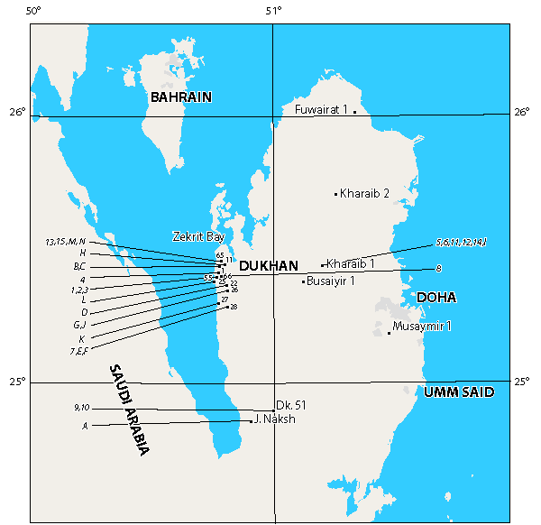
The Qatar Peninsula (Fig. 1 ![]() ) has an area of some 12,000 sq. km and projects 170 km northwards into the Gulf from the shore of Arabia. To the north-west lies the island of Bahrain; to the west, the Hasa Province of Saudi Arabia, and to the southeast, the Sheikhdom of Abu Dhabi, one of the United Arab Emirates.
) has an area of some 12,000 sq. km and projects 170 km northwards into the Gulf from the shore of Arabia. To the north-west lies the island of Bahrain; to the west, the Hasa Province of Saudi Arabia, and to the southeast, the Sheikhdom of Abu Dhabi, one of the United Arab Emirates.
The peninsula is formed by a large, broad anticline which exposes a carapace of Eocene limestones, rising in the interior to a maximum elevation of 60 m. Its surface is largely stony desert, having little topographical relief. On the west coast, the elongate Jebel Dukhan anticline is marked by the presence of a series of low jebels. In the south occur small hills composed of Miocene sediments. Wind-blown sand forms dunes in the south and south-east.
The system of rock unit terminology described herein has been evolved over a period of some 38 years by geologists of the Qatar Petroleum Company (Q.P.C.). The Company held the petroleum exploration concession for the whole of onshore Qatar and its territorial waters from 1935 to 1961. Since the latter date Q.P.C. has progressively relinquished parts of the territory, currently retaining rights to an area of some 2141 sq. km (825 sq. m.), on the west side of the peninsula which includes the Dukhan oilfield. This oilfield was discovered in 1939, and remains the only producing field in onshore Qatar.
Exploration rights in offshore Qatar waters were once held fully by Shell Company of Qatar (S.C.Q.) which, in the period since 1954, has discovered two commercial oilfields, at Id-al-Shargi and Maydan Mahzam. This company adopted the stratigraphic terminology used by Q.P.C., but found it necessary to define some additional formations not recognised in the onshore area and also modified the sense in which certain formation names are applied.
In recent years, S.C.Q. has relinquished a considerable part of its original concession area.
The areas relinquished by Q.P.C. and S.C.Q. have subsequently been explored by other oil companies, which have, however, made no known contribution to the understanding of the stratigraphy of Qatar.
Active exploration for oil by Q.P.C. took place at a time when similar activities were being undertaken in Saudi Arabia, by the Arabian American Oil Company (ARAMCO); in Kuwait, by the Kuwait Oil Company (K.O.C.) and in Iraq, by the Iraq Petroleum Company (I.P.C.) and its affiliates, the Basrah Petroleum Company (B.P.C.) and the Mosul Petroleum Company (M.P.C.). On the opposite side of the Gulf, in Iran, geological exploration was originally undertaken by the Anglo-Iranian oil Company (A.I.O.C.) and, later, by the Iranian Oil Exploration and Producing Company.
The outcrop areas of the Trucial Coast, Oman, Dhofar and South Yemen have a long history of geological exploration. This work was intensified during the last quarter century by oil company geologists, many of them employees of the I.P.C. and its associates.
Click on the image to enlarge it.
Figure 1.-
Location of type and reference sections Qatar Peninsula.
Position of the type localities of the formations which are here formally described. They are all subsurface sections in bore-holes. The position of reference sections for formations whose type locality is outside Qatar is also indicated.
|
Type Localities |
Reference Sections | ||
|
1 |
Simsima Formation |
A |
Lower Fars Formation |
|
2 |
Ruilat Formation |
B |
Dammam Formation |
|
3 |
Laffan Formation |
C |
Rus Formation |
|
4 |
Mauddud Formation |
D |
Umm er Radhuma Formation |
|
5 |
Hawar Formation |
E |
Mishrif Formation |
|
6 |
Kharaib Formation |
F |
|
|
7 |
Qatar Formation |
G |
Nahr Umr Formation |
|
8 |
Fahahil Formation |
H |
Shu'aiba Formation |
|
9 |
Darb Formation |
I |
Ratawi Formation |
|
10 |
Diyab Formation |
J |
Yamama Formation |
|
11 |
K |
Sulaiy Formation | |
|
12 |
Izhara Formation |
L |
Hith Anhydrite Formation |
|
13 |
Hamlah Formation |
M |
Khuff Formation |
|
14 |
Gulailah Formation |
N |
Wajid Sandstone Formation |
|
15 |
Suwei Formation |
|
|
The stratigraphic nomenclature of the sedimentary sequence of a large part of Arabia is almost wholly the result of the work of geologists employed by these oil companies. Physical isolation, together with the commercial requirements of oil exploration led to the setting up of several separate systems of formation names, and instances arose where the name of a rock unit changes at a political boundary. More recently, publication of results, together with discussion of mutual problems, has led to a considerable rationalization of formation names. Local names are so entrenched by long usage, however, that many anomalies still exist. In spite of these, inter-change of ideas and material between companies, together, with recent publications, now make it possible to correlate, with confidence, rock units described from different areas. One such correlation is shown in
Fig. 2 ![]() .
.
Q.P.C. is an associate of the Iraq Petroleum Co. Ltd., (I.P.C.). For this reason, early attempts were made to correlate Qatar rock units with similar formations in Iraq. Several formation names defined in Iraq are currently in use in Qatar.
It would appear logical to correlate with and adopt names from the neighbouring Saudi Arabia. In spite of early publication of details of Saudi Arabian outcrop sections, lack of knowledge of intervening subsurface sections over a long period led to the setting up in Qatar of different formation names. Recent publication of comprehensive descriptions of Saudi Arabian stratigraphy now make possible more accurate comparison of rock units defined in the two areas.
The oldest sediments exposed in Qatar are of Lower Eocene age. All older formations have been studied as small cuttings-samples or cores obtained from the 86 deep wells drilled on the peninsula by Q.P.C. In addition to rock samples, numerous thin sections have been examined. As a result, the criteria on which formations have been erected include microfacies as well as gross lithological character.
In describing rock units found in Qatar, guidance has been sought from the "Code of Stratigraphic Nomenclature", published and periodically revised by the American Association of Petroleum Geologists.
The formations defined herein are those currently used by Q.P.C. They have been adopted, with some modification, by S.C.Q. (, 1965). Some have been used by organisations working further afield, occasionally in a sense different from the original. This publication contains the first formal description of the Qatar rock units.
Modification and standardisation of the rock unit nomenclature of onshore Qatar was completed, by W. , in 1956. By 1959 his work had been accepted for publication as part of the Lexique Stratigraphique International. New information obtained as a result of the drilling of the Dukhan Deep Test Well (Dukhan No. 65) made necessary the revision of some sections. These amendments have now been made, together with other alterations required by changes in regional and local stratigraphic concepts in the intervening years. A.J. , who is responsible for the revised text, accepts responsibility for any errors or omissions which may be found.
The increase in understanding of foraminiferal faunas and carbonate-rock classification during the past few years has coincided with a marked curtailment of active geological exploration in Qatar. In consequence, the formation descriptions which follow are not couched in the most up-to-date petrological terminology, and do not contain extensive fossil lists. The descriptions will be revised at some future date.
Acknowledgments
Many geologists employed by Qatar Petroleum Co. have contributed significantly to the understanding of the stratigraphy of Qatar. Many are mentioned in the text, but special acknowledgment should be made to the late F.R.S. , who performed much of the original stratigraphic work and who also gave guidance and direction to subsequent investigations. M. undertook much of the local palaeontological and stratigraphical investigation over a long period.
Fossil records are taken from published and unpublished reports by M. , J.A. , A.N. , G.F. , F. , T.J. , F.R.S. , R.G.S. , R.P.S. , A. , J. , A.H. , A.J. , and W. .
The authors are indebted to the Management of the Iraq Petroleum Co. Ltd., for permission to publish this paper.
The geology of Qatar is mentioned by G.E. (1908), (1932), and (1933), all of whom paid brief visits. Their work resulted in the knowledge that the surface of the peninsula is largely made up of Eocene limestone. Miocene sediments were recorded from the south, near Salwa.
Oil was discovered in Bahrain in 1932. The first serious geological investigation of Qatar was undertaken in 1933, by E.W. and P.T. . They recognized that Qatar is formed by a large, broad, anticline, which causes Middle Eocene limestones to outcrop over much of the peninsula. A long, narrow anticline on the west coast, forming the Jebel Dukhan, was believed to have the best oil prospects.
Detailed mapping of the Dukhan anticline and several traverses across the peninsula were undertaken in 1934 by D.C. and W.E. .
Field work by T.F. and R. in 1937-38 resulted in the production of a geological map of Qatar, which, with minor modification, has remained the standard map used by Q.P.C.
Exploratory drilling for oil commenced in 1938, on the Dukhan anticline, and, in 1939, the first well encountered oil in the Number 3 Limestone of the Qatar Formation. When operations were suspended in 1942, because of the Second World War, three wells had been drilled at Dukhan to appraise the potential of the No. 3 Limestone.
Drilling on the structure recommenced in 1947 and a total of 80 wells have now been completed in the Dukhan Field.
In 1949, oil was discovered in the Number 4 Limestone of Dukhan. This proved to be a better reservoir than the No. 3 Limestone and has given the greatest oil production. A minor oil accumulation was found in the Middle Jurassic Uwainat Member, in 1954.
Final, detailed mapping of the Dukhan anticline was completed in 1948-49.
Oil production commenced in 1949, Dukhan being linked by pipeline to a terminal at Umm Said, on the east coast.
The surface of Qatar was surveyed by aerial photography in 1947. Gravity and magnetic surveys commenced in the same year. Results of early seismic surveys were poor and attempts were made to further elucidate the structure of the peninsula by drilling a series of shallow wells down to the top Cretaceous.
Two deep wells were drilled near Kharaib in 1953, in order to investigate the oil-potential of the crest of the main Qatar anticline as seen at and near the surface. Disappointing results from these wells led to deeper structure drilling to the north of Kharaib, four wells being sunk to encounter the Mauddud Formation. North plunge at this level was confirmed.
Improved seismic techniques permitted the mapping of deep horizons, demonstrating that these reach a maximum elevation at the north end of the peninsula. This prospect was tested by a deep well drilled at Fuwairat in 1960.
Minor structural features were investigated by deep wells at Busaiyir, Musaymir and Abaruk.
One well was drilled by Continental Oil Co. Ltd, at Al Karanah.
General
The Qatar Peninsula lies on the broadest part of the "Interior Platform" of the Arabian Shelf which fringes the exposed basement rocks of the Arabian Shield (R.W. et al., 1966). This platform extended, through much of geological time, from south Iraq, through eastern Saudi Arabia and Qatar into parts of the Trucial Coast. It is typified by a flat-lying, relatively thin sequence of sediments laid down upon gradually subsiding basement.
Qatar is supposed, by R.W. (1966), to lie on an extension of the Central Arabian Arch, a basement ridge which extends in an E.N.E. direction through the Summan area. A continuation of this feature is thought to be responsible for the probable extension of the Interior platform into parts of Iran, north of Qatar.
This simple pattern is slightly complicated by the presence of a number of deep-seated N-S epeirogenic, anticlinal features which rise above the general level of the Platform. These "plains type" structures are typified by very gentle surface dips which increase progressively with depth. Their growth history can be traced back to the early Mesozoic or late Paleozoic and is probably related to deep-seated movement of basement blocks. Qatar owes its existence to its position on one of these structures.
Brief Geological History
The pre-Permian is represented in Qatar by sandstones and quartzites. These were encountered in the Dukhan Deep Test Well and in well Musaymir No. 1. Fossils of Devonian and Carboniferous age are recorded from this rock unit which, because of its lithology and stratigraphic position is compared with the Wajid Formation of Saudi Arabia. This phase of clastic deposition probably continued into the early Permian, to be followed by a period of widespread quiescent marine conditions during which the Khuff Formation, a shallow marine limestone unit, was deposited over much of Arabia.
During the late Permian and early Triassic the Qatar area experienced a further incursion of clastics from the Arabian Shield. The sequence of fine silts and sands with interbedded dolomites which make up the Suwei (Sudair) Formation suggests that Qatar is near the limit of clastic deposits during this period.
The red beds of the Suwei Formation are overlain in Qatar by a series of anhydritic carbonates (the Gulailah Formation) which are the lateral equivalent of the Jilh Formation of subsurface Saudi Arabia. The unit was probably laid down under shallow shelf conditions which persisted through a tectonically quiet phase of the Triassic. The continental sands of the Minjur Formation which mark the close of the Triassic in Saudi Arabia are not found in Qatar.
The close of the Triassic and beginning of the Jurassic is marked by an important sedimentary hiatus equivalent to the pre-Marrat unconformity of Saudi Arabia. This truncates the Gulailah Formation over the main Qatar arch and, possibly, over minor structures and also affects the thickness and development of the early Jurassic formations. Of the latter, one, the Hamlah Formation has been recognised only in Dukhan, a long, narrow anticline on the west flank of the main Qatar swell. Its absence from the centre and east of Qatar suggests that the axis of uplift ran approximately north-south through the eastern part of the peninsula at this time. Only towards the close of the Mesozoic did the current situation with the maximum of uplift along the centre-line of the peninsula occur.
With minor exceptions, the Jurassic was a period of relatively quiet, largely shallow-water marine conditions, accompanied by almost continuous carbonate deposition, terminated by a final shallowing which gave rise to the thick, economically important anhydrite-limestone cycles of the Fahahil, Qatar and Hith Formations. Originally considered to be "evaporites" resulting from the effect of arid conditions on a silled basin, these anhydrites could now equally be regarded as the result of early diagenesis in widespread, rapidly forming salt-flat deposits of a type currently seen on the coast of Abu Dhabi.
Argument as to the age of these terminal anhydrites continues, but the upper limit of the Hith Formation is conventionally regarded in Qatar as marking the close of the Jurassic. The formation marks the final infilling of the Jurassic "basin".
Another major cycle of carbonate sedimentation commenced with the deposition of the early Lower Cretaceous, Sulaiy Formation and ended with the widespread, Aptian, Shu'aiba Formation. During this period, Qatar was an area of almost continuous limestone deposition with only slight influence, during the Barremian and ? Hauterivian of conditions which gave rise to the thick sands of the Zubair or Biyadh Formations nearer the Arabian Shield.
Uplift over Qatar during the Lower Cretaceous is demonstrated by cut-out and probable unconformity at the base of the Kharaib Formation and, possibly, at the top of the Yamama Formation.
The Nahr Umr Formation, which succeeds the Shuaiba, represents the last major clastic phase to extend as far as Qatar. Regional uplift during the Albian Stage appears to have given rise, over Qatar, to deltaic or swamp conditions.
The Mauddud Formation marks a return to shallow-water limestone deposition in the late Albian. It is succeeded by a sequence of Cenomanian shallow-water limestones and marls of the Ahmadi and Mishrif Formations, terminated by a major unconformity which delineates the boundary between the Wasia and Aruma groups.
The "Upper" Cretaceous was a period of active tectonism over much of Arabia. This resulted, in Qatar, in a much condensed sequence, the middle part of which has only recently been correlated with formations in neighbouring areas. The basal unit – the Laffan Shale is a valuable marker bed of widespread occurrence. A major intra-Campanian sedimentary break truncates the succeeding Halul Formation over the whole of Qatar. It is overlain by the Ruilat Formation, a spicular limestone reflecting the regional deepening which resulted in the deposition of basinal sediments of the Fiqa Formation in neighbouring areas. The youngest Mesozoic unit – the Simsima Formation – is overlain by the basal shale of the Umm er Radhuma Formation. This state of affairs extends over much of south-east Arabia, and is accompanied by an abrupt change from a typical Maestrichtian to a paleocene microfauna.
Shallow, shelf conditions continued through the Paleocene and Lower Eocene, shallow-water limestone deposits passing upwards into chalks and "evaporites" of the Rus Formation which marks the close of the depositional cycle. Over Qatar the Rus Formation is thin and shows less development of anhydrite than in surrounding areas.
The succeeding Dammam Formation marks the final phase of uniform marine carbonate deposition which typified the Qatar area for so long.
With the extension of minor subsidence during the early Miocene, during which sediments of the Lower Fars were laid down, the late Tertiary history of Qatar has been one of regional uplift, erosion, or non-deposition.
The major, late Tertiary, orogenic movements of the Zagros appear to have had no effect upon the Qatar area.
Structure
Three main structural elements can be recognised in Qatar. The major part of the peninsula is formed by a broad, north-south trending anticline. This is separated by a syncline from the more pronounced, narrow, elongate Dukhan anticline which runs parallel to the west coast. All three features are visible on the surface and have been mapped, using the "Alveolina Bed" of the Dammam Formation as a marker horizon.
The surface expression of the main Qatar anticline is a broad, shallow dome having a culmination in the centre of the peninsula near Kharaib well No. 1. Dips on the flanks and north plunge are of the order of one half to two metres per kilometre. The south plunge is less clearly defined.
The Qatar anticline retains its domal form in the sub-surface but north plunge disappears at about the level of the Nahr Umr Formation. At greater depths units rise northwards along the axis of the fold to reach a maximum elevation in the vicinity of Fuwairat.
Evidence from deep wells suggests the possibility that the Qatar axis of uplift may have originated to the east of the present-day crest, which was initiated during the late Mesozoic.
The Dukhan anticline extends southwards from Ras Dukhan for some 40 km before swinging S.S.E. and continuing towards the border with Saudi Arabia. The culmination of this structure is in the north, near Dukhan. Appreciable flank dips of the order of one to two degrees can be discerned on the surface. These increase with depth as a result of downflank thickening of the sedimentary sequence. This flank thickening can be recognized in most formations, a fact which suggests that the structure has been developing at least since the early Mesozoic.
The geometry and mode of formation of these "plains type" folds has been discussed by (1962). Formation by differential compaction over buried basement highs is rejected.
R.W. et al. (1966) suggest sedimentation over continually developing basement horsts as the most probable explanation of the broad, N-S- epeirogenic folds found in Qatar and nearby areas.
The Dukhan anticline with its narrow elongate form and relatively steep dips contrasts with most of the neighbouring folds. This fact has led to the suggestion that its formation may be related to deepseated salt intrusion (, 1965).
Notes on Time Stratigraphy
Figure 2 ![]() illustrates the correlation of rock units over a large area of eastern Arabia and also summarises currently available information on their age. One striking feature of this diagram is the number of formation boundaries which follow time planes. The resulting "layer-cake" stratigraphy reflects the effect of widespread epeirogenic movements of the Arabian Shelf which have resulted in synchronous, region-wide changes in sedimentary regime.
illustrates the correlation of rock units over a large area of eastern Arabia and also summarises currently available information on their age. One striking feature of this diagram is the number of formation boundaries which follow time planes. The resulting "layer-cake" stratigraphy reflects the effect of widespread epeirogenic movements of the Arabian Shelf which have resulted in synchronous, region-wide changes in sedimentary regime.
As a result of this fact, it has proved possible to use fossils, whose occurrence is almost certainly facies-controlled, as local time indices, their age being established by association with accepted index fossils in a few, widely separated, localities.
Few formations can be assigned definite ages in Qatar on the basis of their contained fauna. The concept of region-wide isochroniety of certain geological events has, however, permitted their dating by reference to better established age criteria in neighbouring areas.
When differences of opinion as to the age of a formation exist, they usually involve no more than one Stage. Widely differing age determinations for similar sequences, such as that of Umm Shaif (Abu Dhabi) have been shown to be erroneous.
Diachronous formation boundaries are quite common within the framework provided by the major synchronous events. These usually reflect increasing distances from the source of sediment on the Arabian Shield.
International practise has been followed in the application of time-stratigraphic terminology, with one major exception in the Cretaceous System.
Sediments of Cretaceous age can be split into three major rock-stratigraphic units, viz. the Aruma, Wasia and Thamama Groups. The widespread sedimentary breaks which separate these Groups on the shelf are approximate time planes. As a result, a tripartite subdivision of the Cretaceous System has evolved in the Middle East over a long period. It is used, without comment or explanation, by many authors.
The accepted subdivision is as follows:
|
SYSTEM |
INTERNATIONAL SUBDIVISION |
MIDDLE EAST SUBDIVISION |
STAGE |
GROUP |
|
|
CRETACEOUS |
UPPER |
UPPER |
MAESTRICHTIAN CAMPANIAN SANTONIAN CONIACIAN |
ARUMA |
|
|
MIDDLE |
TURONIAN CENOMANIAN ALBIAN |
WASIA |
|||
|
LOWER |
|||||
|
LOWER |
APTIAN BARREMIAN HAUTERIVIAN VALANGINIAN BERRIASIAN |
THAMAMA |
|
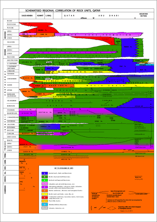
Click on the image to enlarge it.
Figure 2.- Schematised relationship of the Qatar rock units to those in neighbouring areas (Artwork by Dana , TAMU-Qatar).
Obsolete terms are marked with asterisks.
|
Eocene ? Middle Eocene |
Informal name applied to a sequence of white, hard, leached limestone, underlain by softer chalky limestones and basal marls, which forms a distinctive topography to the north of Jebel Dukhan; the highest member of the Dammam Formation in Qatar.
Most fossils have been leached out and no formal dating is possible. One specimen of Dictyoconoides sp. was recorded from the highest part of the unit in 1938, but no further discovery of identifiable foraminifera has been made.
A Middle Eocene age is assigned on the evidence of apparent conformity of the Abaruk Beds with underlying, datable Lutetian carbonates, together with their similarity to the Alat Member of the Dammam Formation in the Trucial States could be a correlative unit.
First named and described by E.W. and P.T. in 1933, during a geological reconnaissance of Qatar.
|
Cretaceous Cenomanian |
Author
R.M.S. and S.N. , 1958
Synonymy
"Khatiyah Formation", , 1953. (unpublished) "Ahmadi Formation", et al., 1959. "Ahmadi Member", and , 1965. "Khatian Formation", , 1965. "Ahmadi Member", et al., 1966. "Ahmadi Formation", , 1967.
Type Section
K.O.C. Well Burgan No. 62, in Kuwait
Reference section in Qatar
Q.P.C. Well Dukhan No. 28, lat 25°17'12" N, long. 50°48'46" E, elevation 32m (106 ft), completed 1.5.1952, between drilled depths 727 and 925m (2384 and 3035 ft).
Thickness
198 m (651 ft)
Lithology
Top. 1. Limestone ; light grey, fine grained, porous, wackestones and packstones with numerous thin beds of marl and shale, blue-grey to brown. 99 m (326 ft). 2. Shale, blue-grey and marly towards base. 54 m (176 ft). 3. Limestone ; light grey, porous wackestones and packstones. 16 m (53 ft). 4. Shale, brown, and blue-grey, with thin beds of argillaceous sandstone in middle. 29 m (96 ft). Base
Fossils
In 1. Praealveolina cretacea (d'), Cisalveolina fallax , Meandropsina vidali , Flabellammina sp. In 2. P. cretacea, M. vidali, Flabellamina sp., Orbitolinella depressa , Serpula filiformis , Trigonia crenulata , Corbula truncata , Pecten orbicularis (), Mitra cancellata , Protocardium hillanum , Cerithium albensis d', Turritella difficilis d', Aspidiscus cristatus , Exogyra conica (), E. luynesi , E. larteti , Fusus ornatus d', Cerithium vibrayeanum d', P. cretacea, Trocholina arabica , Trocholina lenticularis var. minima . In 3. P. cretacea, T. arabica. , Serpula filiformis , Trigonia crenulata , Corbula truncata , Pecten orbicularis (), Mitra cancellata , Protocardium hillanum , Cerithium albensis d', Turritella difficilis d', Aspidiscus cristatus , Exogyra conica (), E. luynesi , E. larteti , Fusus ornatus d', Cerithium vibrayeanum d', P. cretacea, Trocholina arabica , Trocholina lenticularis var. minima . In 3. P. cretacea, T. arabica. In 4. P. orbicularis, P. hillanum, E. conica, E. larteti, Turritella granulata , Alectryonia macroptera , Gervillia rostrata , Nucula subrecurva , Neithea quinquecostata , Anomia laevigata , Pteria anomala (), Camptonectes curvatus , T. lenticularis, P. cretacea.
Age
The foraminiferal fauna is compatible with a Cenomanian age and this age is conventionally applied to the whole Ahmadi Formation in Qatar. It was originally suggested that the macrofauna of units 2 and 4 could indicate an Albian age, but this is considered unlikely since the youngest Albian formation normally recognised in areas where accurate dating is possible, is the Orbitolina concava bearing Mauddud Formation (see et al., 1959, and , 1967).
Underlying
Mauddud Formation. The lowest shales of the Ahmadi Formation rest with apparent conformity upon light grey limestone of the Mauddud.
Overlying
Mishrif Formation. The conformable contact is well defined by rapid upward passage from shales and marls of the upper Ahmadi into continuous limestones of the Mishrif formation. The lithologic change is normally sharp but occasionally gradational.
Other localities
Deep wells throughout the Qatar peninsula and some offshore areas. South Iraq and Kuwait, and parts of Saudi Arabia. Also recorded as the Ahmadi Member of the Sarvak Formation of S.W. Iran.
Remarks
At its type locality, in Kuwait, the Ahmadi Formation is a relatively thin (76 m) shale unit (the Cap Rock Shale) with a thin limestone unit near its base. In the Basrah area the name Ahmadi is applied to a sequence of shales and limestones of Cenomanian age. The succession in Dukhan is so similar to that in South Iraq that the older name Khatiyah was replaced by Ahmadi Formation in 1961.
The Ahmadi Formation of Qatar overlies the Mauddud Formation and underlies the Mishrif, occupying the position of the Ahmadi and Wara Formations of South Iraq. The top of the Mauddud Formation is believed by (1959, 1967) to coincide with a widespread regional unconformity which marks the close of the Albian Stage. The Ahmadi is, therefore, believed to be wholly Cenomanian in age in Qatar.
Qatar lies close to the eastern limit of the typical, argillaceous facies of the Ahmadi. Progressive eastwards replacement of shales by limestones occurs until, in Abu Dhabi, the Ahmadi has been wholly replaced by thick shelf limestone assigned to the Mishrif Formation.
|
Paleocene-Eocene |
Obsolete name originally used in the Basrah area of Iraq, to describe the Lower Eocene to paleocene carbonates which underlie the Rus Formation. Applied to a comparable unit in Qatar for a short time. Superseded by the name Umm er Radhuma Formation.
|
Middle Eocene (Lutetian) |
Informal name first applied by T.R. and R. , 1938, to a thin (maximum 5 m) unit commonly made up of two limestones, white to yellow, containing an abundant fauna of Alveolina elliptica var. flosculina, separated by a thin argillaceous bed. Overlies the Midra Shale Member of the Dammam Formation. Correlates with the Alveolina Limestone Member of the Dammam Formation in Saudi Arabia and also occurs in Bahrain.
Used as a mappable marker horizon in the geological survey of Qatar.
|
Upper Jurassic |
Informal name commonly applied in Qatar and Abu Dhabi to the combined Qatar and Fahahil Formations. Adopted from Saudi Arabia where it was first applied to the rock unit which contains the Arab A, B, C, and D Members. Later defined as the Arab Formation.
The name Arab Zone is obsolete in Saudi Arabia and has never been defined.
See Qatar and Fahahil formations.
|
Cretaceous (Campanian) |
Neritic, shelf-carbonate member of the Fiqa' Formation. In Qatar, only found in Dukhan Well No. 51 (Juh-1).
See Fiqa' Formation.
|
Jurassic (Bathonian–Callovian) |
Author
W. (unpublished report)
Synonymy
"Upper and Middle Dhruma Formation" et al., 1966. "Araej Formation", , 1965. "Araej Formation", , 1967. "Araej Formation", and , 1968.
Type Locality
Q.P.C. Well Kharaib No. 1, lat 25°27'09"N, long. 51°11'56" E, elevation 41.5 m (136 ft), completed 29.6.1953, between drilled depths 2137 and 2316 m (7010 and 7600 ft).
The formation takes its name from the Jebel Araej in Southern Qatar.
Thickness
180 m (590 ft)
Lithology
Top 1. Limestone, grey, foraminiferal, pellet-grainstone and packstone with some interbedded wackestone and lime mudstone. Pellets often black and pyritic. Some horizons argillaceous. 31 m (102 ft). 2. Limestone; buff, medium to coarse grained, bioclastic pellet-lump grainstone to packstone, porous; particles of buff colour without pyrite staining. 59 m (193 ft). 3. Limestone, light to dark grey, compact to dense, comprising interbedded pyrite-stained pellet grainstone and packstone, wackestone and lime mudstone. Occasional beds of calcite-cemented oolite 61 m (201 ft). 4. Limestone, grey wackestone to lime mudstone, with some interbedded pellet packstone and occasional grainstone; pellets rarely pyrite stained; some horizons silty. 28.6 m (94 ft). Base.
Fossils
In 1. Chlamys curvivarians , Terebratula cf. superstes , Trocholina palastiniensis , Nautiloculina oolithica , Kurnubia sp. In 2. Cladocoropsis cf. zuffardiae , Stromatoporina cf. somaliense , Camptonectes sp., N. oolithica, T. palastiniensis, Pfenderina neocomiensis , P. trochoidea et . In 3. N. oolithica, T. palastiniensis, Pfenderina sp. In 4. N. oolithica, Pfenderina sp. In addition to the above, there occur throughout the formation, but particularly in unit 2, a number of simple arenaceous fossils which have not been named and, also fossils referred to Paleotrix . (The fossil recorded above as P. neocomiensis is now believed to more closely relate to P. salernitana et ).
Age
Callovian to Bathonian – based on correlation of the Araej Formation with the Upper and Middle Dhruma Formation of Saudi Arabia (see Remarks below).
Recently published results of work on ammonites by (1970) suggest that the Upper Araej and Uwainat Member should be assigned to the Callovian Stage and the Lower Araej to the Bathonian.
Underlying
Izhara Formation. Contact conformable. At junction of impure, silty, pellety, grey limestones of the basal Araej, above, with buff, pure, wackestone and packstone of the upper Izhara, below.
Overlying
Diyab Formation, contact probably disconformable. At sharp junction of highest, coarse, pyritic, trocholina-bearing grainstone of the Araej Formation with argillaceous lime mudstones and fine pellet limestones of the basal Diyab.
Other localities
This formation is widespread in S.E. Arabia being known throughout Qatar, in the subsurface, in Bahrain, and Saudi Arabia, underlying much or all of the Trucial States and passing in attenuated form into Oman.
Remarks
Correlation of the Araej Formation with the Upper and Middle Dhruma Formation of Saudi Arabia has been accepted for some time. The equivalence of the "Fadhili Zone" (now the Lower Fadhili Reservoir) to the Uwainat Member of the Araej (unit 2, above) was the key to this correlation. The publication of detailed descriptions by R.W. et al., 1966, makes accurate correlation with the Saudi Arabian outcrop section possible.
The Atash Member of the Upper Dhruma is undoubtedly the equivalent of the Uwainat Member of the Araej Formation. Both are typified by the Pfenderina trochoidea assemblage which appears to be restricted to this unit in Arabia.
The Upper Araej (Unit 1), typified in Qatar by pellet grainstone and packstones with abundant Trocholina palastiniensis, must be related to the Hisyan Member, which contains numerous limestones bearing the same foraminifera in a similar facies. The Upper Araej is itself widely recognised in S.E. Arabia. In Qatar the upper limit of the Araej Formation is sharply defined, with marked lithologic and faunal difference from the overlying Diyab Formation. To the east, away from the Qatar axis, the unit thickens and passes gradationally into the Diyab by gradual reduction of coarse pellet debris and increase of fine lime mudstone and fine pellet calcarenite. In such situations it is not always possible to select a precise formation boundary. The thin Upper Araej development and its sharp contact with the Diyab, in the Qatar area, is suggestive of a sedimentary break between the two formations.
The contact of the Uwainat Member with the Upper Araej is abrupt but conformable, with no evidence of erosion or non-deposition.
The Uwainat Member passes down gradationally into the Lower Araej. The latter is correlated with the Middle Dhruma because of its conformable position beneath the equivalent of the upper Dhruma and above the Izhara Formation, whose upper member is believed to coincide in position and age with the Dhibi Limestone Member.
|
Cretaceous (Coniacian-Maestrichtian) |
Author
R.M. and S.N. , 1958
Four formations are currently assigned to the Aruma Group in Qatar. These are the Simsima Formation (Maestrichtian), Ruilat Formation (Campanian), Halul Formation (Campanian-Santonian), and Laffan Formation (Santonian-Coniacian). The Group is separated by sedimentary breaks from the overlying Umm-er Radhuma Formation and the underlying Mishrif Formation. Its age-range and stratigraphic relationship are similar to those of the Aruma Group of Kuwait and South Iraq whence it was first formally described.
The Aruma Group of and is similar to the Aruma Formation of Saudi Arabia, where it is most fully developed in the subsurface. The application of Group status to a thick, heterogeneous rock unit, which has retained formation rank in its country of origin, results from the fact that many of its component rock units were validly assigned formation rank at an early date.
An intra-Campanian unconformity described from Kuwait and South Iraq can also be recognised in Qatar and other regions to the south-east. The type Aruma Formation, which occurs at outcrop in the scarp of the Al' Aramah plateau of Saudi Arabia, includes Upper Campanian to Maestrichtian sediments which fall wholly above this unconformity. The application of the name Aruma to a Group or a Formation including units which are separated by an unconformity from the type Aruma is of doubtful validity (H.V. , 1967). The practise has become accepted over so long a period that it is retained in Qatar.
From 1940 to 1953, a predominantly limestone unit which underlies the Umm er Radhuma Formation and overlies the Laffan Shale was included, by Q.P.C., in one formation. Because the only datable section was Maestrichtian, this limestone was named the Tayarat Formation by comparison with a formation of that age in Iraq.
When this sequence was subsequently subdivided into two rock units, the younger, of Maestrichtian age (truly synonymous with Tayarat) became known as the Simsima Formation to avoid local confusion. The underlying, undated, limestone was named the Ruilat Formation. Detailed structural and palaeontological studies had, meanwhile, proved that a major unconformity occurs below the Laffan Shale, indicating that it is more closely related to the overlying, conformable Ruilat Formation. Recent inter-company liaison has resulted in the recognition of an unconformity within the original Ruilat Formation. The lowest part is therefore segregated from it and assigned to the Halul Formation, which was originally recognised in offshore Qatar.
At the same time, convincing evidence that the Laffan Shale Formation is no older than Coniacian was discovered, thus settling a long-standing controversy of regional importance.
|
Cretaceous (Cenomanian) |
Obsolete formation name, originally used in Iraq, which was applied for a short time to the lower, mainly shale, section of the Ahmadi Formation of Qatar. Adopted when the recognition of the Mishrif Formation in Qatar necessitated a second revision of status of the Khatiyah Formation. The name Khatiyah was temporarily abandoned, the section between the Mishrif and Mauddud Formations being subdivided into an upper limestone-marl unit (named the Rumaila Formation) and a lower argillaceous unit (the Asara Formation). A 12 m limestone bed within the latter was named the Tuba Member after a comparable unit in south Iraq.
The names Rumaila and Asara were abandoned in Qatar in 1956, the units to which they were applied being recombined into an amended Khatiyah Formation. This subsequently became known as the Ahmadi Formation.
A Turonian age was erroneously ascribed to the "Asara Formation" when it was first described in Qatar.
|
Paleocene-Eocene |
G.E. , 1908, applied the name Bahrain Series to the succession of Middle and Lower Eocene rocks which outcrop on Bahrain Islands. The name was adopted in Qatar and redefined, in 1940, to describe the total Middle Eocene to base Paleocene succession encountered on the surface and in wells. Later confined to the surface-outcropping Eocene formations, comparable to the original section in Bahrain. Became obsolete in 1954 when the name Hasa Group was adopted to describe the combined Dammam, Rus, and Umm er Radhuma formations.
|
Paleocene-Lower Eocene |
Obsolete formation name applied, in 1953, to the predominantly limestone and dolomite sequence of Lower Eocene and paleocene age which underlies the Rus Formation.
The local name Busaiyir Formation was superseded by Umm er Radhuma Formation, described by N.J. (1952), from Saudi Arabia.
See Umm er Radhuma Formation
|
Cretaceous ? Santonian |
The basal member of the Halul Formation of offshore Qatar can be correlated with a thin limestone section which overlies the Laffan Formation in the Dukhan Field. The contact of the latter with the overlying Ruilat Formation has the appearance of a sedimentary break. The name Da'asah Member, derived from a location close to the reference section, has been assigned to this widespread lower section of the Halul Formation.
See Halul Formation
|
Eocene ? Lower & Middle Eocene |
Author
M. , R.A. and N.J. , 1958 (first formal definition).
Synonymy
"Dammam Formation", and , 1958. "Dammam Formation", van , 1959. "Formation de Dammam", , 1962. "Dammam Formation", , 1965. "Dammam Formation", and , 1965. "Dammam Formation", et al., 1966. "Dammam Formation", , 1967. "Dammam Formation", , 1967. "Dammam Formation", and , 1968.
Type section
The type section is in the rim rock of the Dammam Dome, Saudi Arabia.
Reference section in Qatar
A complete section between Dukhan (lat. 25°26' N, long. 50°47' E) and the head of Zekrit bay (lat. 25°28' N, long. 50°49' E).
Thickness
52 m (ca. 170 ft)
Lithology
Top 1. Limestone light grey, rubbly. 1.8 m (ca. 6 ft). 2. Dolomite, chalk, white, with disseminated silica. 10.6 m (35 ft). 3. Limestone, light grey, interbedded with white dolomitic chalk. Chert nodules of frequent but irregular occurrence. 33.5 m (110 ft). 4. Shale, light grey, with foliate cleavage, varying to light grey marl, irregular orange to yellow iron staining. 5.5 m (18 ft). Bottom.
Fossils
In 3. Echinocyamus nummuliticus et , Echinolampas ovalis de , Euspatangus ornatus (), E. formosus (de ), Schizaster africanus de , Sismondia polymorpha et , Nummulites lucasanus d', N. somaliensis et , N. discorbinus (), Linderina brugesi , Alveolina elliptica () var. flosculina , A. delicatissima , Dictyoconoides cooki (), Lockhartia cf. hunti , L. hunti var. pustulosa , L. tipperi (), Covkinolina balsilliei . In 4. Ostrea turkestanensis .
Age
Middle Eocene (Lutetian) but unit 4 could be Lower Eocene, as in Saudi Arabia.
Underlying
Rus Formation; contact conformable. At the boundary of shale, above, with chalky limestone below.
Overlying
Nothing in the reference section. In the southern part of Qatar the Dammam is unconformably overlain by the Lower Fars.
Other localities
Forms the surface of a large part of Qatar; also outcrops extensively in Saudi Arabia and Bahrain. Known from bore-holes in the Basrah area and Kuwait, to the north, and in Abu Dhabi and Oman, to the south-east.
Remarks
The name Dammam Formation was first used in Qatar in 1953, following the restricted distribution of 's Thesis in 1952. Earlier subdivision of outcropping Eocene into Abaruk Beds, Upper Limestone and Lower Limestone ceased at that time.
The Abaruk Beds comprise units 1 and 2 of the reference section. No age-diagnostic fossil is known from them, with the exception of one specimen of Dictyoconoides which was reported in 1938. Failure to find further specimens has caused doubt to be cast upon the Middle Eocene age assigned on the basis of this record but the similarity of the Abaruk Beds to the Alat Member of Saudi Arabia and to the White Limestone and Orange Marl of Bahrain supports such an age determination. In sections other than the reference section, the basal part of the Abaruk Beds is a thin (1,5 m) marl.
Unit 3 of the reference section is the Upper Limestone of early reports. It forms the main, datable, Middle Eocene limestone sequence of the Dammam Formation. Its base is defined by a thin, but persistent, limestone, containing abundant Alveolina elliptica var. flosculina, known as the Alveolina Bed, which has been used as a marker horizon for mapping purposes. Unit 3 correlates with the Khobar Member and Alveolina Limestone Member of the Dammam Formation of Saudi Arabia.
The basal shale member of the Dammam Formation in Qatar is typically yellow-green. It contains common fish remains and pelecypod casts but no age-diagnostic fossil has been reliably recorded from it. A Middle Eocene age is conventionally assigned to this shale because no local proof of any other age is available in Qatar. The name Midra Shale is applied to it.
The above subdivision can be closely compared with that of the type Dammam Formation described by et al. (1958). Subsequent addition of the Saila Shale Member, separated from the Midra Shale Member by a thin limestone, adds complication. Impersistant limestones occur within the basal shale member in Qatar but no mappable subdivision can be made. It is assumed that the equivalent of both Midra and Saila Members are to be sought in the basal Shale Member of the Dammam in Qatar. The name Midra Shale is retained, being established by usage and having priority.
The boundary of the Rus and Dammam Formations is conventionally defined in Qatar and Abu Dhabi as the base of the Midra Shale. This marker is easily recognized over wide areas in both surface and subsurface sections and follows described practice in Saudi Arabia (, 1966 and 1968).
|
Upper Jurassic Lower Kimmeridgian |
Author
W. (unpublished report).
Synonymy
None.
Type locality
Q.P.C. Well Dukhan No. 51 (formerly Juh. No. 1), Lat 24°53'48" N long. 50°59'55" E, elevation 76.5 m (252 ft), completed 25.10.1952, between drilled depths 2166 and 2377 m (7107 and 7800 ft).
The formation takes its name from the Ta'as al Darb, a solitary sand dune near the type locality, which marks the ancient track to Mecca.
Thickness
211 m (693 ft).
Lithology
Top 1. Limestone, grey and light grey, lime mudstone, compact to dense. Dolomite streaks and bands of pyrite-stained pellet packstone. 50 m (163 ft). 2. Limestone, dark grey lime mudstone, dense with rare streaks of pyritic pellet packstone. 53 m (174 ft). 3. Limestone, grey lime mudstone, dense, becoming argillaceous downwards: numerous thin beds contain scattered, large, pyrite-stained pellets. 40 m (131 ft). 4. Limestone, dark grey, dense, lime mudstone, becoming increasingly argillaceous towards the bottom. 68 m (225 ft). Base.
Fossils
In 1. Kurnubia jurassica (), Kurnubia cf. wellingsi (), Pseudocyclammina jaccardi (). In 2 and 3. K. jurassica, K. cf. wellingsi, P. jaccardi, Nautiloculina oolithica , Pseudocyclammina cf. virguliania . In 4. P. jaccardi, P. cf. virguliania, N. oolithica, K. jurassica. In the lowest two feet Exogyra nana (J. ).
Age
Upper Jurassic. The presence of Pseudocyclammina jaccardi throughout the sequence and its absence from the underlying Diyab Formation suggests that the Darb could be the lateral equivalent of the Jubaila and Hanifa Formations of Saudi Arabia. The determination of the Kurnubia species is based on work prior to publication (1964) of 's new species. As suggested by R.W. et al., 1966 (page 56), the form determined as K. cf. wellingsi in this formation, could well be random sections of K. morrisi , which range through all of the Jubaila and the upper part at least of the Hanifa Formation. Thus, a largely Kimmeridgian age is accepted for the Darb Formation, although some Oxfordian could be represented.
Underlying
Diyab Formation; contact conformable, placed at the position where dense, argillaceous lime mudstone of the basal Darb Formation rests upon fine, calcarenitic limestone with interbedded, very argillaceous lime mudstone of the uppermost Diyab Formation.
Overlying
Fahahil Formation (Arab No. 4 Limestone); contact conformable. In type section placed at boundary between fine lime mudstone of the Upper Darb Formation and porous dolomite of the basal Fahahil Formation. At other localities in Dukhan and, more markedly, to the east, the uppermost Darb Formation becomes increasingly dolomitised. As a result, an additional porous section is added to the base of the Fahahil Formation, at the expense of the Darb Formation.
Other localities
Well established as a separate formation only in the Qatar area, where it has been encountered in many deep wells.
Remarks
The typical Darb facies can be traced into the Trucial States, where it has not, however, proved possible to separate with confidence a Darb and a Diyab Formation within the interval bounded by the Fahahil Formation and the Araej Formation. It is normally possible to distinguish an argillaceous lower unit which could be compared in general with the Diyab Formation. This facies is, however, variably developed and sometimes almost absent.
The Darb Formation must be the lateral equivalent of most, or all, of the Jubaila and Hanifa Formations of Saudi Arabia. The latter names have not been adopted in Qatar because it has not proved possible to trace their exact lithological equivalents.
|
Upper Jurassic |
Author
W. (unpublished report).
Synonymy
None
Type locality
Q.P.C. Well Dukhan No. 51 (formerly Juh. No. 1), lat 24°53'48" N, long 50°59'55" E, elevation 76.5m (252 f.), completed 14.10.1952, between drilled depths 2377 and 2476m (7800 and 8125 ft).
The formation takes its name from a locality on the south part of the Dukhan anticline.
Thickness
99m (325 ft).
Lithology
Top. 1. Limestone, dark grey, fine grained lime mudstone, dense, thin bedded, very argillaceous, with thin interbeds of dark grey marl and of grey, dense, fine, calcarenite containing some quartz grains. 23m (77 ft). 2. Anhydrite, white, 0.6m (2 ft). 3. Limestone, dark grey, fine grained, argillaceous lime mudstone, thin bedded, with streaks of grey, dense, fine calcarenite, as in unit 1 but with less quartz. Very rare thin beds of chert. 23 m (72 ft). 4. Anhydrite, white. 1.8 m (6 ft). 5. Limestone, grey, fine grained lime mudstone, dense. 9.4 m (31ft). 6. Limestone, dark grey to black, very argillaceous, silty, slightly dolomitic, in part finely fissile, carbonaceous, particularly in lower part; occasional thin streaks of fine grained calcarenite. 40 m (132 ft). Base.
Fossils
In 1. Nautiloculina oolithica , Glomospira sp. In 3. N. oolithica, Glomospira sp., Exogyra nana (J. ), Perisphinctes sp., In 6. Pholadomya cf. inornata (J. de C. ), Gryphaea balli (), Liostrea arabica , Chlamys macfadyeni , E. nana, Modiolus imbricatus (J. ), Dichotomoceras cf. D. anomalus .
Age
Upper Jurassic. The contained fauna gives no precise indication of age, which must, therefore be sought by correlation with the better dated sections described from Saudi Arabia. Originally considered to equate with the Tuwaiq Mountain Limestone, the Diyab Formation is now thought to be possibly correlatable with the black, argillaceous, ammonite-bearing unit described from the basal Hanifa formation of Fadhili. If this is correct, a Kimmeridgian age must be ascribed to the Diyab. Insufficient information is known of the lateral variations of the Hanifa and Tuwaiq Mountain Limestone to permit the unqualified acceptance of one or other correlation. An age from Callovian to Kimmeridgian could therefore be possible.
Underlying
Araej Formation. At sharp contact of dark grey to black argillaceous limestone and fine calcarenites of the Diyab with grey pellet grainstones of the Upper Araej Formation. The contact is apparently conformable, but could represent a considerable break in sedimentation.
Overlying
Darb Formation; contact conformable. Placed where dense, argillaceous lime mudstone of the basal Darb overlie very argillaceous lime mudstones with interbedded fine sandy calcarenites of the Diyab Formation.
Other localities
Recognised as a separate formation only in Qatar, where it has been encountered in many deep wells. Dark grey argillaceous limestones occur above the Araej Formation to the east in Abu Dhabi, but a distinct Diyab Formation has not been distinguished.
Remarks
, 1968, states that the basal, argillaceous unit of the Hanifa Formation is separated by an hiatus from the lower, Cuneolina-bearing beds of the Tuwaiq Mountain Limestone in the central coastal area of Saudi Arabia, close to Qatar. The Diyab Formation may be the equivalent of the basal Hanifa. The Cuneolina-bearing beds have not been recognized in Qatar, although their equivalent may occur to the east, in Umm Shaif, where additional section containing Meyendorffina sp. occurs between typical Araej and Diyab lithologies. The upper unit of the Araej in Qatar is equated with the Hisyan Member of the Dhruma Formation. Thus, the Diyab-Araej contact could represent a considerable break in sedimentation, spanning the Oxfordian and possibly part of the Callovian eras, resulting from uplift over the Qatar arch. Should the Diyab contain equivalents of part of the Tuwaiq, there probably still remains a break between it and the Araej, represented by the Cuneolina-bearing beds and their equivalents (the Meyendorffina-bearing bed) which are present on either side of the Qatar axis.
|
Upper Jurassic |
Obsolete, unpublished formation name proposed by W. , 1953, to distinguish a unit composed of limestone containing abundant anhydrite nodules from the underlying massive anhydrite of the Hith Formation. Now considered to be the upper member of the Hith Formation.
|
Jurassic Lower Kimmeridgian |
Author
W. (unpublished company report).
Synonymy
"Lower, carbonate part of the Arab D Member", , 1968. "No. 4 Limestone" of Qatar.
Type locality
Q.P.C. Well Dukhan No. 66, lat 25°20'53" N, long. 50°48'47" E, elevation 23 m (76 ft), completed 18.5.1960, between drilled depths 1964 and 2021 m (6444 and 6631 ft). The formation takes its name from a locality on the Dukhan anticline near the type section.
Thickness
57 m (187 ft).
Lithology
(After F. , unpublished report). Top. 1. Dolomitic lime mudstone with streaks of dolomite and anhydrite, dolomitic packstone; two foot anhydrite bed near top. 6.4 m (21 ft). 2. Interbedded grainstone, wackestone and packstone of skeletal grains in lime mudstone matrix. Upper 9m predominantly grainstone. 42 m (139 ft). 3. Alternating dolomitic lime mudstone and dolomite. 8.2 m (27 ft). Base
Fossils
In 1. Prethocoprolithus sp., Aeolisaccus dunningtoni . In 2. Kurnubia jurassica (), Nautiloculina oolithica , Salpingoporella annulata , Burgundia trinarchii var. , Cladocoropsis mirabilis , Stromatoporina choffati (), S. romanica (), S. somaliense (), S. annulata, Clypeina jurassica et , C. cf. hanabatensis et , Lithoporella melobesioides . In 3. K. jurassica.
Age
An Upper Jurassic, probably Lower Kimmeridgian, age is inferred by the above fauna and flora, and, also, by the stratigraphic position of the unit above the Darb Formation, which is itself partly equivalent to the Lower Kimmeridgian, Jubaila Formation of Saudi Arabia
Underlying
Darb Formation; contact conformable. At the junction of porous dolomites of the Fahahil Formation, above, with dense lime mudstones of the Darb Formation, below.
Overlying
Qatar Formation; contact conformable. At the junction of dolomite, anhydritic lime mudstone of the Upper Fahahil Formation, below, with massive anhydrites of the basal unit of the Qatar formation, above.
Other localities
Extends throughout the oilfield area of Qatar, Bahrain and Saudi Arabia, but is unknown from Kuwait northwards. Its equivalent can be recognised in Abu Dhabi.
Remarks
This unit is easily defined in western Qatar and much of Saudi Arabia. In eastern Qatar, increasing dolomitisation of the Upper Darb Formation makes it virtually impossible to distinguish a stratigraphic equivalent of the base of the formation as defined in Dukhan. Much increased dolomitisation of this nature, farther to the east, probably is reflected in the conditions met in the Umm Shaif oilfield, where the name Arab Darb has been introduced.
The lower unit (3) of the reference section could be related to the underlying Darb as easily as to the Fahahil Formation. It has been demonstrated (F. , unpublished report) that the Fahahil marks a transition from deeper to shallower water conditions. It is this transitional nature, together with the unit's great commercial value as an oil reservoir, which prompted W. to segregate it as a distinct formation, instead of incorporating it either in an Arab Formation (as in Saudi Arabia) or in the Darb Formation.
|
Cretaceous (Coniacian -) Campanian |
Author
A.J. and E. Hart (unpublished report)
Synonymy
"Shargi Formation", , 1965. "Upper Shale", , 1967. "Aruma marl", and , 1968.
Type locality
A.D.P.C. well Murban No. 44, lat. 23°10'22" N. long. 53°20'35" E, elevation 133.5 m (438 ft), completed 20.9.1965, between drilled depths 1653 and 2003 m (5422 and 6571 ft).
Thickness
350 m (1149 ft)
Lithology
Top. 1. Light grey, very chalky marl grading into a white chalk with, locally, rare, slightly silty shale partings. Interbeds of chalky, foraminiferal, lime wackestones, containing fine skeletal debris. 39 m (128 ft). 2. Dark grey-green, calcareous shale and light grey, chalky marl grading into a white chalk. Thin interbeds of buff detrital, chalky, foraminiferal lime wackestone containing shell debris and light grey argillaceous limestone, 42 m (137 ft). 3. Limestone, light buff, slightly argillaceous, chalky lime wackestone, particles consisting of smaller foraminifera and shell and echinoid debris. 49 m (161 ft). 4. Shale, dark grey, slightly calcareous, with chalky marl. 18 m (60 ft). 5. Pale buff, chalky to locally argillaceous limestone interbedded with dark grey, sometimes calcareous, shale, which tends to predominate in the lowest 40 ft. 35 m (116 ft). 6. Pale grey to buff, slightly chalky foraminiferal wackestone with particles consisting of shell debris; interbeds of grey-green shale. 54 m (178 ft). 7. Dark grey-green shale grading into grey marl with thin interbeds of light grey-buff, fine lime wackestone. 30 m (100 ft). 8. Shale, dark grey-green. 71 m (233 ft). 9. Limestone, light grey, argillaceous, locally pyritic. 11 m (36 ft). Base.
Fossils
In 1. Monolepidorbis douvillei , Rotalia aff. trochidoformis, aff. Archaecyclus sp. In 2. M. douvillei, R. aff. trochidiformis, aff. Archaecyclus sp., Ataxophagium sp. In 3. M. douvillei, R. aff. trochidiformis, Rotalia sp., aff. Archaecyclus sp., Bryozoa and echinoid debris. In 4 and 5. M. douvillei, R. aff. trochidiformis. In 6. M. douvillei, M. sanctae-pelagiae , rare Globotruncana sp., crab debris, echinoid spines, Bryozoa, rudist fragments, fish remains. In 7. M. sanctae-pelagiae, Pseudedomia aff. multistriata. In 8 and 9. Globotruncana gr. fornicata , Globotruncana arca arca (), Globotruncana arca () caribica , Globotruncana globigerinoides , Globotruncana cf. concavata (), Globotruncana contusa (), Rugoglobigerina beldingi , Planoglobulina sp., Gumbelina spp., Ostracoda including Bairdoppilata sp., Cytherella sp., Paracypris glabrans ms., Brachycythere wellingsi ms.
Age
Campanian.
Underlying
Halul Formation, contact disconformable. Grey, argillaceous limestone of the basal Fiqa' Formation rests upon pure, dense, chalky limestone of the Halul.
Overlying
Simsima Formation, contact probably disconformable, at boundary between pure lime wackestone and packstone of the Simsima and argillaceous carbonates of the Fiqa'.
Other localities
Found in the subsurface of most of Abu Dhabi and offshore Qatar and in one well section in onshore Qatar (see remarks). Extends eastwards into Oman, where its age range is extended to Coniacian, and into Saudi Arabia, where it is fully developed in the subsurface. The basal unit of the type section of the Aruma Formation probably correlates with part of the "Arada Member" (see remarks)
Remarks
The Fiqa' Formation includes two distinct members: 1. The 'Arada Member (units 1 to 7 of the type section which takes its name from a locality some 33 km S.S.E. of the type locality. This shallow-water unit is probably the equivalent of the shallow-water facies carrying Monolepidorbis sanctae-pelagiae reported from the Lower Aruma of Saudi Arabia (R.W. , 1968). 2. The Shargi Member (units 8 and 9 of the type section) is named from Id-al-Shargi, Qatar, where it is the only member of the Fiqa' Formation present between the Simsima and Halul Formations. A comparable facies is present in the Lower Aruma of Saudi Arabia.
When both are present, the 'Arada Member invariably overlies the Shargi Member.
This description is included in the Qatar Lexicon because the Fiqa' Formation has been recognised in one well section to the south of the Dukhan Field in onshore Qatar. The following sequence occurs in Dukhan Well No. 51 (formerly Juh-1) between the Simsima and Halul Formations: 1. Limestone, bioclastic wackestone and packstone yielding Monolepidorbis sanctae-pelagiae, Rotalia trochidoformis. 17 m (55 ft). 2. Shale, blue-grey, containing planktonic foraminifera including Globotruncana arca, Gl. Lapparenti, Gl. gr. stuarti. 58 m (190 ft).
Unit 1 represents the 'Arada Member and unit 2 the Shargi Member of the Fiqa' Formation. There is evidence to suggest that the Ruilat Formation which is recorded from all other areas of onshore Qatar is the lateral equivalent of the Fiqa' Formation and, hence, Campanian in age.
|
Triassic ? Middle Triassic |
Author
W. (unpublished report).
Synonymy
"Dolomite-Anhydrite series" of early unpublished reports on Arabia. "Jilh Formation", and , 1952.
Type locality
Q.P.C. Well Kharaib No. 1, lat. 25°27'09" N, long. 51°11'56" E, elevation 41.5 m (136 ft), completed 29.6.1953, between drilled depths 2454 and 2615 m (8052 and 8578 ft). The formation takes its name from a locality near the type section.
Thickness
160 m (526 ft).
Lithology
Top. 1. Dolomite, grey and dark grey, fine grained, dense, calcareous, anhydrite, partly argillaceous, with interbedded anhydrite, grey and white. Authigenic quartz common. 27 m (88 ft). 2. Dolomite, grey, fine grained, dense, partly calcareous. 25 m (84 ft). 3. Anhydrite, grey, alternating with calcareous dolomite, grey, fine grained, dense, argillaceous. Occasional thin beds of shale, dark grey, calcareous. Authigenic quartz. 11 m (38 ft). 4. Limestone, grey, fine grained, dense, partly dolomitic, with streaks and nodules of anhydrite. Very argillaceous in upper and lower few feet. Lower half pellety in parts. 37 m (122 ft). 5. Limestone, grey and grey-brown, fine grained, dense, pellety in part, dolomitic, grading to dolomite, grey, fine grained, dense, anhydritic with interbeds of white to grey-brown anhydrite. Authigenic quartz throughout. 35 m (116 ft). 6. Limestone, grey, fine grained, dense, grading to dolomite, calcareous, containing a little grey anhydrite. 23.8 m (78 ft). Base.
Fossils
In unit 4. Rare Ammodiscus sp. and Glomospira sp.
Age
A Triassic age is assumed on the basis of the formation's stratigraphic position above the Suwei (Sudair) Formation and its lateral equivalence to the Jilh Formation. The presence of Lingula tenuissima in the Gulailah Formation of Q.P.C. Well Dukhan No. 65, adds a little support of this age assignment.
The synonymous Jilh Formation of Saudi Arabia, has been assigned a Middle to Lower Triassic age, confirmed by palynological studies.
Underlying
Suwei Formation, contact probably conformable; placed where brown to grey shales and marls of the upper Suwei underlie limestones and dolomites of the basal Gulailah Formation.
Overlying
Izhara Formation; contact unconformable, placed at the top of the highest anhydrite of the Gulailah.
A similar relationship is seen in Q.P.C. Well Musaiymir No. 1, but in Well Dukhan No. 65, an additional unit, the Hamlah Formation, intervenes between the Gulailah and the Izhara – See Hamlah Formation.
Other localities
Deep wells on the Dukhan structure and at Musaiymir in eastern Qatar. Probably penetrated by deep wells in offshore Qatar ("Khail Formation" , 1965). Is the lateral equivalent of the Jilh Formation as developed in subsurface areas of Saudi Arabia.
Remarks
When first penetrated, in Well Kharaib No. 1, the Gulailah was believed to correlate with part of the Dhruma Formation of Saudi Arabia, while the underlying red beds of the Suwei Formation were equated with the basal Jurassic, Marrat Formation. With the completion of the Dukhan Deep Test Well it became apparent that this correlation was incorrect, the Gulailah being lithologically similar to the Jilh Formation of nearby areas of Saudi Arabia and in the same relative stratigraphic position.
The top of the Gulailah Formation is marked by a widespread unconformity, the equivalent of the pre-Marrat unconformity of Saudi Arabia. This results from a period of late Triassic to early Jurassic uplift and erosion which were effective both regionally and locally over individual structures. The time interval represented by this hiatus saw the deposition of the continental sands of the Minjur Formation in areas closer to the Arabian Shield.
In Qatar, this unconformity causes cut-out of the Hamlah Formation between Dukhan and Kharaib, accompanied by marked thinning of the Gulailah in the same, easterly direction.
|
Cretaceous Santonian-Campanian |
Author
M.W. , 1963 (unpublished report)
Synonymy
"Halul Formation", , 1965 (first published reference). "Ilam Formation", and , 1965. "Middle Chalk", , 1967. "Aruma Lower Limestone", and , 1968.
Type locality
S.C.Q. Well Id-al-Shargi No. 1, lat. 25°23'32.9" N, long. 52°21'55.93" E, between drilled depths 1009 and 1081 m (3310 and 3545 ft.). The formation takes its name from the island of Halul, off the east coast of Qatar.
The following description is adapted from one by W.O. , P.J.C. and I.W.G. of S.C.Q.
Thickness
72 m (235 ft).
Lithology
Top. 1. Limestone, light grey, chalky bioclastic lime packstone, particles consisting of larger foraminifera with some smaller foraminifera, ostracods and shell fragments. 27 m (90 ft). 2. Limestone, light grey, chalky bioclastic lime wackestones, particles consisting of spicules, small shell fragments with some smaller foraminifera and larger foraminifera, some pyrite and scattered dolomite rhombs. 21 m (68 ft). 3. Marl, grey-green, soft with some shale, blue-grey and some limestones, light grey-light brown, chalky, partly recrystallised. 8.6 m (27 ft). 4. Chalk, light grey, soft, frangible, occasionally slightly marly, with limestones, light grey and light brown, chalky, partly recrystallised, shell fragments in places. 15 m (50 ft). Base
Fossils
In 1. Pseudedomia sp. (p), (P. aff. complanata-globularis), Rotalia aff. trochidiformis , Dicyclina cf. schlumbergeri , Kathina sp. nov., Dictyokathina sp. nov., Rotalia sp. nov., ostracods, spicules, echinoid fragments, ? Oligostegina. In 2. Pseudedomia aff. complanata-globularis, Rotalia aff. trochidiformis , Kathina sp. nov., Rotalia spp. nov., spicules, ? Oligostegina.
Age
Upper Cretaceous, Santonian-Campanian.
Underlying
Olive-green shales and marls of the Laffan Formation conformably underlie the light grey, chalky wackestones of the Halul Formation.
Overlying
Fiqa' Formation; the basal brown calcareous shales of the Fiqa' overlie light grey, chalky lime-packstones of the Halul Formation. Contact believed to be unconformable.
Other localities
Of limited development in onshore Qatar where only the lower, Da'asah Member is recognised. Well developed in offshore Qatar and in central, north and parts of eastern Abu Dhabi, whence it thins rapidly to the south and east. Apparently not present in Oman.
The Halul Formation probably equates with a unit containing a faunule composed chiefly of Kathina sp. and Cosinella sp. which occurs in the subsurface of eastern Saudi Arabia, (R.W. , 1968). The S'adi Formation of south Iraq and the Ilam Formation of south-west Iran are equivalents of the Halul Formation.
Remarks
A widespread and persistent rock stratigraphic unit, which can be recognised by its characteristic foraminiferal assemblage.
The lower part (units 3 and 4) of the type section represent the only part of the Halul Formation to be recognised in onshore Qatar. This unit has been named the Da'asah Member after a locality south of Q.P.C. Well Dukhan No. 55, the site of the reference section, described below.
Reference section in onshore Qatar
Q.P.C. Well Dukhan No. 55, lat. 25°24'0" N. long. 50°43'46" E, elevation 7 m (23 ft), completed 17.8.1956, between drilled depths 570 and 584 m (1870 and 1906 ft).
Thickness
14 m (46 ft).
Lithology
Top. 1. Limestone; light grey, fine, compact, partly silicified lime mudstones to wackestones. 10 m (32 ft). 2. Limestone, grey, argillaceous lime mudstone. 4 m (14 ft).
Fossils
In 1., small indeterminable foraminifera, probably including Heterohelix sp..
Age
Probably Santonian, from stratigraphic position
Underlying
Laffan Formation, contact conformable. At sharp change from lime mudstone above, to shales of the Laffan Formation below.
Overlying
Ruilat Formation, contact disconformable. At junction of grey lime wackestone of the Da'asah Member of the Halul Formation with glauconitic limestones of the basal Ruilat Formation. This contact represents a major hiatus within the Aruma Group, equivalent to the pre-Hartha unconformity of south Iraq.
The Da'asah Member of onshore Qatar was originally the basal part of the Ruilat Formation. Recent comparison with offshore sections illustrated its similarity to a basal member of the Halul Formation to which formation it is now assigned.
|
Lower Jurassic |
Author
A.J. (unpublished report)
Synonymy
None
Type locality
Q.P.C. Well Dukhan No. 65, lat. 25°27'38" N, long. 50°47'13" E. elevation 42.6 m (140 ft), completed 21.10.1960, between drilled depths 2367 and 2436.5 m (7764 and 7992 ft).
The formation takes its name from a locality on the west coast of Qatar
Thickness
69.5 m (228 ft).
Lithology
Top. 1. Dolomite, grey and brown to dark grey, dense to porous, saccharoidal. Stringers and nodules of anhydrite in the upper part. Becoming argillaceous downwards. 5 m (16 ft). 2. Shale, dark grey-green, with subordinate marl, grey, and some green glauconitic sandstone and dolomite. 6 m (20 ft). 3. Dolomite, dark grey, calcareous, with anhydrite streaks, interbedded with green shale, and grey marl. 9 m (30 ft). 4. Dolomite, grey-brown, interbedded with grey, dense limestone and some anhydrite. 41 m (135 ft). 5. Sandy marl with beds of shale, dark grey. 8 m (27 ft)
Fossils
None.
Age
Lower Jurassic age inferred. The formation's conformable relationship with the overlying Izhara Formation which is believed to be Middle Jurassic and the unconformity between it and the Triassic rocks of the underlying Gulailah Formation support this deduction.
Underlying
Gulailah Formation; contact unconformable. At contact of sandy marl and shale of the basal Hamlah, above, with dolomites of the Gulailah, below.
Overlying
Izhara Formation, contact apparently conformable, placed at the horizon where blue-grey shales with interbedded dolomite of the basal Izhara Formation overlie grey, fine grained dolomite of the Hamlah Formation.
Other localities
Encountered only in the Dukhan Field in Qatar. Possibly represented by part or all of the "Gulailah Formation" of , which underlies the Izhara Formation in offshore areas of Qatar
Remarks
Originally included in the Gulailah Formation (s.s.) but difficulties arose since this attribution resulted in an appearance of continuous sedimentation from the Triassic to the Middle Jurassic with no indication of the widespread pre-Toarcian unconformity known to exist in neighbouring areas. Discovery of a marked change in structural configuration at a drilled depth of 7992 ft in Well Dukhan No. 65 made it necessary to separate the unit from the Gulailah.
The Hamlah Formation could be considered to be an additional, lower unit of the Izhara Formation not present in the type locality. The Izhara can however, be mapped as a distinct rock unit over a wide area. The lithology of the Hamlah is sufficiently different for it to be considered a valid formation.
The Izhara Formation is conventionally correlated with the whole Lower Dhruma. For this reason the Hamlah is correlated with the Marrat Formation and assigned a possibly Lower Jurassic, Toarcian age.
Although the Hamlah Formation is known only from one part of Qatar, its presence over a large area which is structurally lower than the present and Mesozoic crests of the Qatar arch can be reasonably assumed. The thickness of the Hamlah Formation at different localities will depend upon the degree of structural activity during the late Triassic and early Jurassic.
|
Paleocene-Eocene |
The name Hasa Series was first proposed by N.J. , 1952, and published by him in 1962. Meanwhile, it had been adopted by R.M.S. and S.N. , 1958, R.C. van , 1959, and other workers as the Hasa Group.
The name is applied to the complete sequence which comprises the Dammam, Rus and Umm er Radhuma Formations, all of which have their type sections and are extensively exposed in the Hasa Province of Saudi Arabia. In proposing this name, rejected the earlier name Bahrain Series, whose exact significance was open to doubt.
The name has not been officially adopted in Saudi Arabia (R.W. , 1968).
|
Cretaceous Barremian or Lower Aptian |
Author
W. , 1953 (unpublished report).
Synonymy
None
Type locality
Q.P.C. Well Kharaib No. 1, lat. 25°27'09" N, long. 51°11'56" E, elevation 41 m (136 ft), completed 29.6.1953, between drilled depths 1109 and 1125 m (3637 and 3689 ft).
Thickness
16 m (52 ft)
Lithology
Shale and marl, blue-grey.
Fossils
Choffatella decipiens
Age
Lower Aptian or Barremian
Underlying
Kharaib Formation; contact conformable, placed at boundary between limestone, below, and shales or marls, above.
Overlying
Shu'aiba Formation; contact conformable; limestones of the Shu'aiba rest upon shales of the Hawar Formation
Other localities
Occurs throughout onshore Qatar and can be traced eastwards through offshore Qatar where it changes progressively into a characteristic limestone unit composed of foraminiferal, pellet packstones and wackestones and argillaceous lime mudstones, often highly glauconitic and dense. This limestone can be traced eastwards through Abu Dhabi and probably extends into Oman. Everywhere it intervenes between the Shu'aiba and Kharaib Formations. The shale is present in Bahrain and forms the highest unit of the Biyadh Formation in eastern areas of Saudi Arabia.
Remarks
Justification for assigning formation rank to this relatively thin unit is its value over a wide area as a distinctive rock unit which intervenes between the well-defined Shu'aiba and Kharaib Formations.
The Hawar Formation was, for many years, considered to be the upper member of a heterogeneous formation which also included the Kharaib and Ratawi Formations as defined in this Lexicon. The name Ratawi was assigned to the complete sequence which was considered to be a distant equivalent of the Zubair / Ratawi clastics complex of south Iraq.
|
Jurassic Upper Jurassic |
Author
M. , R.A. and N.J. , 1958; amended by R.W. et al, 1966
Synonymy
None
Type locality
In Saudi Arabia
Reference section in Qatar
Q.P.C. Well Dukhan No. 25, lat. 25°22'52" N, long. 50°45'50" E, elevation 23 ft., completed 30.12.1951, between drilled depths 1178 and 1928 m (5862 and 6324 ft).
Thickness
141 m (462 ft)
Lithology
Top. 1. Limestone, brown and grey-brown, dense, dolomitic, with abundant nodules of anhydrite. 12 m (40 ft). 2. Limestone, brown, oolitic, dolomitised. 4 m (13 ft). 3. White, nodular anhydrite with abundant streaks and stringers of dense or compact brown dolomite. 35 m (117 ft). 4. Anhydrite, white, massive, rarely with stringers of dolomite. 30 m (98 ft). 5. White nodular anhydrite with numerous stringers of brown dolomite. Several thin beds of porous, oolitic or pellety, brown, dolomitised limestone. 20 m (66 ft). 6. Anhydrite, white to light brown, massive, partly with stringers of brown dolomite. 29 m (94 ft). 7. Anhydrite, white, nodular, with numerous stringers of dark brown dolomite changing downwards to dolomite, grey-brown, with abundant nodules of anhydrite. A six foot bed of dolomitised oolitic limestone near the base. 10 m (35 ft). Base.
Fossils
Undeterminable vestiges.
Age
Not known precisely owing to the lack of fossil evidence. According to the age attributed to the underlying Qatar Formation it is supposed that the Hith is Upper Jurassic, possibly Tithonian. This agrees with the latest age proposed for the Hith Formation in Saudi Arabia ( et al., 1966).
Underlying
Qatar Formation, contact conformable. The contact is taken at the top of the purely carbonate upper member of the Qatar Formation. Beds showing gradational change to massive anhydrite are included in the Hith, contrary to practise in Saudi Arabia (H. et al., loc. cit.). ARAMCO practise has publication priority but the alternative, long established in Qatar records, is retained as a matter of convenience.
Overlying
Sulaiy Formation, contact conformable. At the highest occurrence of limestones with abundant nodular anhydrite typical of the upper unit of the Hith Formation.
Other localities
Throughout the oilfield areas of Saudi Arabia, Bahrain and Qatar. The formation can be traced eastwards into Abu Dhabi but disappears in the eastern part of that State as the result of erosion or facies change. It is absent from Oman
Remarks
The top of the Hith Anhydrite is commonly accepted as a convenient time boundary between the Jurassic and Cretaceous Systems in many parts of Arabia. This position is maintained in Saudi Arabia in spite of suggestions based on palynological studies that the Hith and upper Arab Formation could be of Lower Cretaceous age (O.D. , 1965).
Evidence for a lower Cretaceous age assigned to a similar anhydrite unit occurring in Umm Shaif, Abu Dhabi (F.E. Banner and G. , 1964) was refuted by H.V. (1967).
A Jurassic (probably Tithonian) age is applied to the Hith Formation in Qatar in conformity with majority practise.
The mode of origin of this widespread (Iraq to Abu Dhabi and south Rub-al-Khali) anhydrite unit is open to conjecture. Originally supposed to result from evaporation in a silled basin, the Hith Anhydrite could have formed in a shallow, hypersaline sea (W. , 1963). Some, at least, of the sequence may result from diagenesis in supratidal sediments resulting from processes similar to those recorded from present-day coastal sabkhas in Abu Dhabi.
The Hith Anhydrite marks the final shallowing and infilling of the long-established Jurassic sea in which vast thicknesses of limestone were deposited over much of Arabia.
An equivalent of the Hith Anhydrite can be traced northwards into Iraq, as the Gotnia Formation. It can also be recognised in south-west Iran. The halite deposits recorded from the south-west Rub-al-Khali extend southwards to form the Sabatayn Formation which is found in the salt-domes of the Shabwa area of western Hadhramaut.
|
Lower Cretaceous Valanginian-Hauterivian |
Obsolete formation name proposed, in 1956, to describe the sequence which currently includes the basal part of the Ratawi Formation and the Yamama Formation in Qatar. The sequence assigned to the Huwaila Formation had previously been subdivided into four formations, named the Rakan, Karanah, Qartas and Misfir. These distinctive lithologic units became members of the new formation.
The Huwaila Formation was subsequently thought to be synonymous with the Yamama Formation of Saudi Arabia and the latter name was applied to it. The definition of the Yamama Formation was later revised in Qatar, excluding the upper member, which is now included within the Ratawi Formation.
|
Jurassic Bajocian - ? Bathonian |
Author
W. (unpublished report)
Synonymy
"Lower Dhruma Formation", , 1968. "Izhara formation", , 1965.
Type locality
Q.P.C. Well Kharaib No. 1, lat 25°27'09" N, long. 51°11'56" E, elevation 41.5 m (136 ft), completed 29.6.1953, between drilled depths 2317 and 2454 m (7600 and 8052 ft).
The formation takes its name from a locality near the type section.
Thickness
137 m (452 ft).
Lithology
Top. 1. Limestone, grey, porous, with scattered dolomite crystals. 24.4 m (80 ft). 2. Limestone, grey to dark grey, fine grained, dense, with streaks containing pellets, often pyrite-stained, sometimes argillaceous, silty. Lowest part variably dolomitic and including beds of dark grey marl and shale. 56 m (185 ft). 3. Limestone, grey, fine-grained, dense in part, very dolomitic. 6 m (20 ft). 4. Dolomite, grey to grey-brown, calcareous, dense at top, becoming porous, saccharoidal. 10.6 m (35 ft). 5. Limestone and dolomite, grey, fine-grained, dense, with argillaceous beds in upper and lower parts. 40 m (132 ft). Base.
Fossils
In 1. Rare Nautiloculina oolithica , Glomospira sp., Paleotrix sp. In 2. Haurania sp.
Age
Middle Jurassic, Bajocian possibly to Lower Bathonian. Based on its conformable position beneath the Callovian to Bathonian limestone of the Araej Formation. Can be correlated with a fair degree of confidence with the Lower Dhruma Formation of Saudi Arabia, recently assigned a wholly Bajocian age by , 1970.
Underlying
Gulailah Formation (at type locality, contact unconformable). Placed at the top of the highest anhydrite bed of the underlying Gulailah Formation. In Well Dukhan No. 65, the Izhara is underlain conformably by the Hamlah Formation (see Hamlah Formation).
Overlying
Araej Formation; contact conformable. At junction of pure, buff-grey, porous, limestone of the Upper Izhara, below, with impure, silty, pellety, grey limestones of the basal Araej Formation, above.
Other localities
Present in deep wells throughout Qatar. The Izhara Formation has also been recognised in Abu Dhabi.
Remarks
The type description is a modification of the original account written after the formation had been penetrated for the first time. It emphasises the presence of a 24 m (80 ft) upper member composed of porous, pure carbonate, predominantly pellet and lump packstones and grainstones with interbedded lime mudstones, which contrast strongly with the impure, variably developed limestone of the overlying Araej Formation and the underlying Lower Izhara. This unit contains a characteristic microfauna including Haurania spp. and forms related to Cockinolinopsis and Orbitopsella. It is the equivalent of the Dhibi Limestone Member (formerly Haurania Limestone) of the Lower Dhruma of Saudi Arabia, and can be traced over a large area of Arabia.
The lower part of the Izhara Formation is composed of interbedded pellet grainstones, argillaceous packstones and lime mudstones, dolomite and shale. These contain increasing quantities of quartz sand towards the base. Thin, discrete sandstone bodies have been recorded in the lower part.
|
Upper Jurassic |
Name proposed, in 1956, to designate, more formally, the Number 1 Limestone of the Qatar Formation. The name has never been published and has become redundant through long disuse.
|
Cretaceous Maestrichtian |
Lower, major member of the Simsima Formation. Includes the Lepidorbitoides socialis and the Orbitoides media faunizones in Qatar.
|
Upper Jurassic |
Name proposed, in 1956, as a more formal designation of the Number 2 Limestone of the Qatar Formation. The name has not been published and is considered redundant because of long disuse.
The name Juh Formation was applied by R.M. (Thesis, 1952) to the Fahahil Formation (No. 4 Limestone) of Qatar.
|
Lower Cretaceous Valanginian |
Obsolete name for the upper, porous pellet, coral, stromatoporoid packstone-wackestone unit of the Yamama Formation of Qatar. Abandoned when correlation with Saudi Arabia became possible.
|
Lower Cretaceous (probably Barremian) |
Author
W. , 1953 (unpublished report)
Synonymy
None
Type locality
Q.P.C. Well Kharaib No. 1, lat 25°27'09" N, long. 51°11'56" E, elevation 41 m (136 ft), completed 29.6.1953, between drilled depths 1125 and 1208 m (3689 and 3962 ft).
Thickness
83 m (273 ft).
Lithology
Top. 1. Limestone, light grey, fine grained, porous, partly crystallised. 24 m (79 ft). 2. Limestone, grey to cream, porous to compact, detrital, in parts with large pellets, interbedded with argillaceous limestone. 41 m (136 ft). 3. Limestone, light grey, porous, fine grained. 18 m (58 ft). Base
Fossils
In 1. Orbitolina discoidea Gras, var. delicata , Dictyoconus arabicus . In 2. O. discoidea var. delicata, Choffatella decipiens . In 3. O. discoidea var. delicata, D. arabicus
Age
Probably Barremian
Underlying
Ratawi Formation; contact apparently conformable but, regionally, considerable cut-out and condensation of beds beneath the Kharaib Formation can be demonstrated over the Qatar arch. Boundary placed at the contact of limestones of the basal Kharaib Formation, above, with marls or shales of the Ratawi Formation, below.
Overlying
Hawar Formation; contact conformable. At contact of marl and shale of the Hawar, above, with limestones of the upper Kharaib Formation, below.
Other localities
Throughout onshore and offshore Qatar and the Trucial States. Probably extends some distance to the west of Qatar where its equivalent is to be found within the Biyadh Formation.
Remarks
This, predominantly limestone, unit can be traced over a vast area of S.E. Arabia, as a continuous carbonate development typified by the occurrence of Orbitolina discoidea, associated at two levels with Dictyoconus arabicus. In Abu Dhabi the Kharaib Formation includes the Zone B plus Zone C Reservoirs of the Thamama Group limestones, which contains important oil accumulations (G.M. , 1967).
To the east of Qatar, the marls and shales of the Ratawi Formation, which underlies the Kharaib, pass into a predominantly limestone facies. In offshore Qatar the name Kharaib has been applied to the complete sequence which underlies the Hawar Shale Formation and overlies the Yamama Formation (J.K. , 1965). This application of the name is contrary to majority practise in the area.
The upper and lower members of the formation are probably better developed equivalents of the "First" and "Second Orbitolina Limestones" recorded from the Biyadh Formation of eastern Saudi Arabia (, 1968).
|
Middle Cretaceous Cenomanian |
Obsolete formation name whose last and best known application was to describe the Cenomanian shale, marl and limestone sequence, now named the Ahmadi Formation, which occurs between the Mishrif and the Mauddud Formations in Qatar.
The name originally applied to the succession, composed predominantly of argillaceous sediments, encountered in the first Dukhan well, which is now subdivided into the Laffan, Mishrif and Ahmadi formations. The Laffan Shale was the first unit to be separated from the Khatiyah, following recognition of an important unconformity at its base.
The redefined Khatiyah Formation showed strong similarity to sections of the same age in South Iraq. In consequence, it was subdivided into Mishrif, Rumaila and Asara formations, the name Khatiyah falling into disuse. The Mishrif Formation has retained its validity in Qatar but the remaining, predominantly argillaceous sequence which occurs between it and the Mauddud Formation was renamed the Khatiyah Formation in 1956, the names Rumaila and Asara being discarded.
In 1961, the name Ahmadi Formation was applied in Iraq to a shale-limestone succession comparable to the Khatiyah Formation in Qatar. As a result the name Khatiyah was again abandoned in Qatar to be replaced by Ahmadi Formation.
|
Permian |
Author
M. , R.A. and N.J. , 1958. The type section is in Saudi Arabia
Synonymy
"Bahrain Unit A", , 1959. "Khuff", , 1965.
Type locality
In Saudi Arabia
Reference section in Qatar
Q.P.C. Well Dukhan No. 65, lat. 25°27'38"N, long. 50°47'13" E, elevation 42 m (140 ft), completed 21.1.1960, between drilled depths 2895 and 3394 m (9494 and 11132 ft).
Thickness
499 m (1638 ft).
Lithology
Top. 1. Dolomite, grey to buff, dense, with thin beds showing relict pellety, oolitic nature. Generally fine, dense, but some saccharoidal. 81 m (267 ft). 2. Dolomitic limestone grading to dolomite, with well-preserved original pellety, oolitic texture. 31 m (101 ft). 3. Dolomite, dark grey, occasional relict pellety and oolitic horizons. Nodules and thin beds of anhydrite in lower part. 134 m (438 ft). 4. Anhydrite with interbedded dolomite, anhydritic. 15 m (50 ft), 5. Dolomite, grey with occasional relict limestone textures. Nodules and streaks of anhydrite. 238 m (782 ft). Base.
Fossils
Hemigordius sp., Padangia sp., Geinitzina cf. ovata , G. sp., Pachyphloia sp., Ozowainella sp., and ? Permocalculus sp., have been identified from units 2 to 5.
Age
The above listed fossils are not age diagnostic but are typical of the Khuff Formation of Arabia, which has been firmly dated as Late Permian in Saudi Arabia.
Underlying
Wajid Sandstones Formation; nature of contact not established. At junction of lowest dolomite of the Khuff, above, with grey-green shales and marls of the Wajid, below.
Overlying
Suwei Formation; contact believed to be conformable. Located where the highest dolomite of the Khuff is overlain by grey and brown shales of the basal Suwei.
Other localities
Deep wells in the Dukhan field and Q.P.C. Well Musaiymir No. 1, in eastern Qatar. Also in deep wells in offshore Qatar and Bahrain. Widespread at outcrop and subsurface in Saudi Arabia and Oman.
Remarks
The Khuff Formation marks the beginning of widespread shallow-water limestone deposition which typifies much of the subsequent sedimentary history of Arabia east of the Shield area. It was laid down in a widespread, shallow, transgressive sea during an interlude in the period of clastic deposition which typified most of the Palaeozoic.
|
Upper Cretaceous Coniacian-Santonian |
Author
W. , 1953 (unpublished report)
Synonymy
"Laffan Formation", , 1965. "Middle Shale", , 1967. "Laffan Shale", and , 1968.
Type locality
Originally described from the interval 610 to 631 m (2002 and 2072 ft) in Q.P.C. Well Dukhan No. 25. The type section is here selected as Well Dukhan No. 55 lat. 25°24'0" N, long. 50°45'46" E. elevation 7 m (23 ft), completed 17.8.1956, between drilled depths 584 and 613 m (1916 and 2011 ft). The formation takes its name from Ras Laffan, on the north-east coast of Qatar.
Thickness
29 m (95 ft).
Lithology
Shale, olive-green
Fossils
The Laffan of the type section has yielded few fossils. The typical ostracod fauna of the Laffan Shale of Dukhan has been described in an unpublished thesis by , 1956. All species are new.
Age
Coniacian to Santonian from its stratigraphic position. Palynological investigation of core samples from the nearby well Dukhan No. 1, indicates an early Senonian age.
Underlying
Mishrif Formation, contact unconformable. Shales of the Laffan overlie chalky, fossiliferous limestones of the Mishrif. On the Dukhan structure, crestal cut-out of beds of the Mishrif beneath the contact can be demonstrated.
Overlying
The Da'asah Member of the Halul Formation overlies the Laffan with apparent conformity. The contact, of shales with argillaceous lime mudstones, is sharp.
Other localities
Found in deep wells throughout onshore and offshore Qatar and much of Abu Dhabi. Also known from Bahrain and parts of Iraq.
Remarks
The Laffan Formation is typically a marine, ostracod-bearing shale which comprises the basal unit of the Aruma Group over a wide area. Its age and affinities were in dispute until recent palynological investigation indicated a Coniacian to Santonian age placing it firmly in the Aruma Group. This position is also indicated by its unconformable relationship to underlying components of the Wasia Group.
When first encountered in Qatar the Laffan Shale was included with an older shale-limestone sequence in the so-called Khatiyah Formation. By 1949 it was apparent that a major unconformity occurred at the base of the Laffan in Dukhan. The unit was then removed from the Khatiyah Formation.
|
Miocene |
Author
H.G. and N.T. , 1918 (first published reference). The Lower Fars Formation is a subdivision of the Fars Series, first defined by G.E. , 1908 in the Fars Province of Iran.
Synonymy
?"Hadrukh Formation" and "Dam Formation", , and , 1958. "Fars", , 1965.
Reference section in Qatar
Jebel Naksh, lat. 24°52' N, long. 50°54' E, approx. This is the best exposed section in the area mapped by Q.P.C.
Thickness
Ca. 79 m (260 ft)
Lithology
Top. 1. Chalky limestone, chalky marls and marl varicoloured. Some beds of harder, sometimes shelly or oolitic limestone. Three thin beds of pure gypsum occur towards the middle, together with gypseous marls and chalks. An 8 ft bed of sandy limestone occurs at the top. 49 m (161 ft). 2. Varicoloured marls, partly sandy with interbedded sandy limestone, sandstone and shale. Thin limonitic beds and nodules occur in marls towards the base. 25 m (82 ft). Base
Fossils
In 1. Dendritina rangii d'. Archais sp. In 2. Ostrea latimarginata . Placuna sp., Discorbis sp., D. rangii.
Age
Lower or Middle Miocene, based on faunal and lithological similarity to the Lower Fars of Iran.
Underlying
Dammam Formation; contact obscured at type locality but, nearby, sandy and marly basal Fars beds, containing scattered quartz and igneous pebbles, overlie the Dammam limestones unconformity but without noticeable discordance in individual outcrops.
Overlying
None. A thin layer of loose gravel caps the Miocene of Jebel Naksh and nearby outcrops
Other localities
Exposed in minor synclines in the Dammam Formation in south Qatar and on the flanks of the southern part of the Dukhan structure.
In Bahrain, sandy limestone, soft grey clays and marls, assigned to the Miocene, are believed to be equivalent to the Lower Fars.
The equivalent of the Lower Fars of Qatar should probably be sought in the Dam Formation of neighbouring Saudi Arabia, which yields a similar fauna and has been compared (R.W. , 1968) with the Lower Fars Formation.
The Lower Fars of Qatar passes eastwards into the thick Fars succession seen in offshore Qatar and the Trucial States, where it is predominantly formed of gypsum-anhydrite.
Remarks
The Miocene sediments of Qatar are a marginal development of the thicker more typical Fars deposits which occur in neighbouring areas. The unit can be traced in a continuous development to its type area in Iran.
The name Lower Fars was first used in Qatar by and in 1933 and has been retained ever since. Its synonymy with the Dam Formation of Saudi Arabia is suggested by the use of that name for the Miocene of South Qatar on U.S.G.S. Geological Maps.
|
Eocene Lower & (?) Middle Eocene |
Obsolete name proposed by and (1938) to describe the sequence of Eocene rocks which outcrops beneath the Alveolina Bed in Qatar. Includes the Midra Shale and the Rus Formation. The former is now assigned to the Dammam Formation. Name abandoned in 1953.
|
Cretaceous Albian |
Author
F.R.S. , 1940 (unpublished report)
Synonymy
"Second Pay Limestone" of Bahrain, Anon., 1937. "Mauddud Limestone", , 1956. "Mauddud Formation", and , 1958. "Mauddud Formation", , 1959. "Mauddud Formation", , 1965. "Mauddud Member", and , 1965. "Mauddud Member", et al., 1966. "Mauddud Formation", , 1967.
Type locality
Q.P.C. well Dukhan No. 1, lat. 25°25'16" N, long. 50°47'01" E, elevation 39 m (128 ft), completed 9.1.1940, between drilled depths 734 and 789 m (2408 and 2589 ft).
The formation takes its name from Ain Mauddud, a locality near Dukhan, Qatar.
Thickness
55 m (181 ft)
Lithology
Grey, foraminiferal limestone, varying from predominantly compact lime mudstone at the base through wackestones to pellety, skeletal packstones and wackestones at the top. At many levels the rock is composed predominantly of tests of Orbitolina and Trocholina.
Fossils
Orbitolina concava () var. qatarica , Trocholina arabica , Trocholina lenticularis , Trocholina altispira , Cyclammina whitei .
Age
Originally believed to be of Cenomanian age (, 1948) on account of the apparent association of Orbitolina concava with Praealveolina cretacea. Records of the latter fossil from the type section have subsequently proved to be due to contamination of well samples by "cavings" from overlying beds.
Similar rocks, containing the same microfauna have more recently been shown by H.V. (1959) to be Albian in Iraq. This age is now applied to the Mauddud Formation in its type locality.
Underlying
Nahr Umr Formation, contact conformable. Defined by change from arenaceous sediments of the Naht Umr, below, to limestone of the Mauddud, above.
Overlying
Ahmadi Formation; contact appears conformable. At abrupt change from typical Orbitolina-Trocholina packstones of the Mauddud to the overlying shales and marls of the basal Ahmadi Formation.
Other localities
Encountered in all deep wells drilled in onshore Qatar. Known also in Iraq, Kuwait, Saudi Arabia, Bahrain, parts of Abu Dhabi and Oman. Recorded from southwest Iran.
Remarks
No formal description of the type section of the Mauddud Formation has previously been published. The name has, however, been applied for many years to the widespread "Orbitolina concava Limestone" found in many parts of the Middle East. The lithofacies of the Mauddud is so distinctive that there is little doubt that the formation has been correctly identified in the majority of cases.
The Mauddud Formation represents a quiet phase of widespread shallow shelf carbonate deposition, marking the close of an Albian cycle of sedimentation which commenced with deposition of the terrigenous clastic of the Nahr Umr Formation.
H.V. (1967) records the presence of an unconformity at the top of the Mauddud in Kuwait and S. Iraq. He believed this sedimentary break to be region-wide and to separate Albian from younger Cretaceous rock units. No physical evidence of such an unconformity is discernible in Qatar or neighbouring areas.
|
Middle Eocene |
The basal member of the Dammam Formation, which immediately underlies the Alveolina Bed. Typically a yellow-green shale. Sometimes, as in the reference section, pale grey and iron-stained. Ostrea turkestanensis and fish teeth are reliably recorded from this member in Qatar. Dictyoconoides cooki has frequently been erroneously recorded. Named after the comparable basal shale member of the Dammam Formation in Saudi Arabia.
Originally included with the Alveolina Bed in the "Dictyoconoides Group" which formed the middle unit of the Eocene sediments mapped by D.C. , 1935.
Assigned to the Lower Eocene in its type area but conventionally placed in the Middle Eocene in Qatar because this age applies to the greater part of the Dammam Formation. A comparable basal unit of the Dammam has yielded Middle Eocene fossils in deep wells in Abu Dhabi.
|
Cretaceous ? Valanginian |
The lowest unit now included in the Yamama Formation was originally assigned the name Misfir Formation. When sufficient evidence became available to permit correlation with Saudi Arabian formations, use of the name Misfir was discontinued. May equate with the upper unit of the revised Sulaiy Formation described by R.W. (1966).
|
Cretaceous Cenomanian-? Turonian |
Author
R.M.S. and S.N. , 1958
Synonymy
"Mishrif Formation", , 1956. "Mishrif Formation", et al., 1959. "Mishrif Formation", , 1965. "Mishrif Member", et al., 1966. "Mishrif Formation", , 1967.
The type section
Is in B.P.C. Well Zubair No. 3, in South Iraq.
Reference section in Qatar
Q.P.C. well Dukhan No. 28, lat 25°17'12" N, long. 50°48'36" E, elevation 32 m (106 ft), completed 1.5.1952, between drilled depth 646 and 727m (2118 and 2384 ft).
Thickness
81 m (266 ft)
Lithology
Limestone; light grey, soft, porous, shell-fragment, foraminiferal wackestone to packstone. Occasional thin shales towards base.
Fossils
Dicyclina qatarensis , Zekritia langhami , Qataria dukhani , Praealveolina Cretacea (d'), Pseudochrysalidina conica , Dictyoconella minima , Dohaia planata , Cuneolina pavonia d', Meandropsina vidali .
Age
A Cenomanian age is assigned in Qatar, as in Iraq, but a Turonian age is possible for the highest part.
Underlying
Ahmadi Formation, contact conformable. Placed at the top of the highest well developed shale horizon of the Ahmadi. In Qatar is selected at contact of more or less continuous pure limestone, above, with interbedded shales and limestones of the underlying Ahmadi. Regionally, the formation boundary is diachronous (see Remarks).
Overlying
Laffan Formation, contact unconformable. At junction of limestones of the Mishrif, with olive-green shales of the overlying Laffan Formation. Crestal cut-out of part of the Mishrif, beneath the Laffan, can be demonstrated on the Dukhan structure.
Other localities
In deep wells throughout the Qatar peninsula and offshore area. Also known from South Iraq, Kuwait, Saudi Arabia and Abu Dhabi.
Remarks
Originally included in the "Khatiyah Formation" of Dukhan until thicker sections, discovered on the flanks of the structure, proved lithologically and faunally comparable to the typical Mishrif Formation of South Iraq.
The Mishrif Formation thickens eastwards from Dukhan as a result of progressive replacement of shales of the Ahmadi Formation by shelf limestones. In onshore Abu Dhabi no vestige of the Ahmadi remains and the name Mishrif is applied to a very thick shallow-water limestone unit of Cenomanian age.
Faunal evidence suggests that the Mishrif Formation is of Cenomanian age in Qatar. It has been assigned to the Turonian in some neighbouring areas and it is not impossible that rocks of that age could occur in the upper part of the formation in Qatar, in areas where the least erosion has taken place.
|
Cretaceous |
Name adopted from Iraq, in 1940, to describe that part of the Qatar succession which occurs between the Nahr Umr Formation (originally Rutbah Sandstone) and the Halul Formation (then the basal Tayarat Limestone). The M'sad Group included the Mauddud Formation together with the original Khatiyah Formation which is now subdivided into Ahmadi, Mishrif and Laffan Formations.
The name M'sad Group was abandoned in Qatar at an early date.
|
Cretaceous |
Name applied, after the drilling of Dukhan well No. 1, to the Cretaceous succession now named the Thamama Group. The Musandam Limestone of the Ruus al Jibal was the only similar unit known in S.E. Arabia at that time (1940).
|
Cretaceous Albian |
Author
R.M.S. and S.N. , 1958
Synonymy
"Nahr Umr Formation", et al., 1959. "Nahr Umr", , 1965. "Wasia Shale", , 1967. "Nahr Umr Shale Formation", , 1967. "Wasia Shale and Nahr Umr", , 1967. "Nahr Umr", and , 1968. "Nahr Umr", , 1967.
The type section
Is in B.P.C. Well Nahr Umr No. 2, in South Iraq.
Reference section in Qatar
Q.P.C. Well Dukhan No. 26, lat 25°20'54" N, long. 50°48'47" E, elevation 24.4 m (80 ft), completed 14.1.1952, between drilled depths 999m and 1167 m (3278 and 3828 ft).
Thickness
168 m (550 ft)
Lithology
Top. 1. Sandstone, grey and greenish grey, glauconitic, rather marly, with numerous thin beds of blue-grey shale and marl and a few thin beds of grey limestone. 32 m (105 ft). 2. Shale, blue-grey and brownish grey, with frequent beds of blue-grey marl. Occasional thin beds of marly, glauconitic sandstone in the upper half. The marl beds commonly contain ferruginous ooliths. 71 m (233 ft). 3. Sand and sandstone, grey, rather marly and with numerous thin beds of marl and shale of various colours. Many stringers and occasional thin beds of lignite yield abundant resin fragments. The more marly parts often incorporate light brown phosphatic concretions or ferruginous ooliths. 65 m (212 ft). Base.
Fossils
In 1. Trocholina lenticularis , Trocholina arabica , Trocholina altispira , Cyclammina whitei . In 2. T. lenticularis.
Age
Albian from its stratigraphic position
Underlying
Shu'aiba Formation; contact believed disconformable. Placed at sharp change from limestone, below to sands and silts, above.
Overlying
Mauddud Formation; contact at conformable boundary between arenaceous to argillaceous clastic sediments, below, and limestone above.
Other localities
Occurs in the subsurface throughout Qatar. Is present in much of eastern Arabia, from Iraq to Oman, in varying lithofacies.
Remarks
Qatar is close to the limit of coarse clastic deposition in the Nahr Umr Formation, which becomes almost wholly composed of shale a short distance to the east.
The application of one formation name to a widespread rock unit which varies from almost pure sand at one extreme to pure shale or shale with interbedded limestone at the other results from the nature of the type section of the Nahr Umr. This section includes sand, shale and limestone (K.M. , 1967) and, hence, can be considered as representing all possible facies variations.
With the exception of Cyclammina whitei, the foraminiferal fauna recorded above could have resulted from contamination of well samples from the overlying Mauddud Formation.
|
(Lower) Cretaceous Valanginian |
Disused formation name applied to the major, middle part of the Yamama Formation before correlation with Saudi Arabia was possible. See Yamama Formation.
|
Jurassic Kimmeridgian-? Tithonian |
Author
First named by W. , 1953 in an unpublished report.
Synonymy
None. (The A, B, C and upper, anhydrite, unit of the D Member of the Arab Formation, R.W. et al., 1966).
Type locality
Q.P.C. Well Dukhan No. 28, lat. 25°17'12" N, long. 50°48'46" E, elevation 32 m (106 ft), completed 1.5.1952, between drilled depths 1903 and 1990 m (6245 and 6529 ft).
The formation takes its name from the Qatar Peninsula, since it contains the first commercial oil reservoir discovered in that country.
Thickness
87 m (284 ft)
Lithology
Top. 1. Limestone, light brown, varying from fine-grained, partly dolomitic and compact to a dolomitised and porous pellety limestone. 11 m (36 ft). 2. Anhydrite, white or light grey, with frequent stringers of brown dolomite near the top and bottom. 12 m (41 ft). 3. Limestone, brown, pellety and dolomitic, and dolomite, brown, porous. 5 m (17 ft). 4. Anhydrite, grey, massive, dolomitic near the top and bottom. 15 m (51 ft). 5. Limestone, grey-brown and brown. 20 ft of dolomitic, anhydritic limestone is underlain by some 40 ft of pellet grainstone and packstone interbedded with lime mudstones. These pass down into a basal oolitic grainstone. 25 m (83 ft). 6. Anhydritic, light brown or light grey, with a 4 ft bed of anhydritic dolomite near the bottom. 17 m (56 ft). Bottom.
Fossils
In 1. Salpingoporella annulata , Favreina salevensis (). In 3. F. salevensis. In 5. F. salevensis, S. annulata, Trocholina palastiniensis , Kurnubia jurassica (), Nautiloculina oolithica , Cerithium ursicinum de , Helicryptus cf. pusilus (), Retusa pellati , Ovacteonina pilleti (de ), Isocyprina boonei.
Age
Upper Jurassic, Kimmeridgian - ? Tithonian. A Lower Kimmeridgian age is assigned to the underlying Fahahil Formation on the basis of its contained fauna and stratigraphic position. The fauna of the lower member of the Qatar Formation (the No. 3 Limestone) shows some affinity with that of the Fahahil. It seems reasonable to regard the Qatar Formation as being Kimmeridgian in age, possibly ranging into the Tithonian.
Underlying
Fahahil Formation; contact conformable, taken at the base of the lowest substantial anhydrite bed of the Qatar Formation.
Overlying
Hith Formation; contact conformable and probably gradational. Picked at junction of limestone containing nodular anhydrite, above, with limestone and dolomite below.
Other localities
Throughout onshore and offshore Qatar. The clear subdivision into alternating anhydrite and carbonate members tends to disappear east of Qatar as a result of increasing anhydrite development. In some areas distinction between the Hith and Qatar Formations cannot be made with any confidence. The formation thins to the east.
The equivalent of the Qatar Formation occurs in large areas of Saudi Arabia, where it forms the major, upper, part of the Arab Formation.
Remarks
The three limestone members of the Qatar Formation can be correlated with the A, B, and C Reservoirs of the Arab Formation of Saudi Arabia (R.W. , 1968). In Qatar these members are informally named the Number 1, Number 2 and Number 3 Limestone from top to bottom. No name has been applied to the anhydrite members which separate the limestones.
The equivalent of the Qatar Formation can be traced in the subsurface of large areas of Saudi Arabia, where it includes important oil reservoirs. The lowest member, the number 3 Limestone, was the first commercial oil producing reservoir to be discovered in Qatar.
The combined Qatar and Fahahil Formations of Qatar are the lateral equivalents of the Arab Formation of Saudi Arabia. The Fahahil Formation (No. 4 Limestone) has also been included with the overlying cyclical carbonate-anhydrite development in the offshore Qatar area. The name Qatar Formation has here been erroneously applied instead of the synonymous, earlier published name Arab Formation.
The practise of including all four "Arab Zone" limestones within one formation has many facts to recommend it. It is not customary in onshore Qatar for historical reasons and also because it was believed that the contact of the Fahahil and Qatar Formations marks a fundamental change from continuous carbonate deposition to the later, cyclical, anhydrite-limestone regime. This fact becomes more obvious to the east of Qatar, where it is often impossible to distinguish the contact of the Fahahil Formation with the underlying Darb Formation. The base of the Qatar Formation can still be recognised in such cases, as the base of the lowest significant anhydrite development.
The Number 1, Number 2 and Number 3 Limestones were assigned the names Jaleha Member, Juh Member and Umm Bab Member respectively. These names have never been published nor have they been applied locally. They are considered to be redundant.
|
(Lower) Cretaceous ? Hauterivian |
Obsolete name originally applied to the argillaceous, pellet limestone which forms the lowest unit of the Ratawi Formation of Qatar. See Ratawi Formation.
|
(Lower) Cretaceous Valanginian -? Barremian |
Author
R.M.S. and S.M. , 1958
Synonymy
"Ratawi Formation", H.V. , 1959, 1967; "Ratawi Formation", K.M. , 1967.
The type section
Is B.P.C. Well Ratawi No. 1, in south Iraq.
Reference section in Qatar
Q.P.C. Well Kharaib No. 1, lat 29°27'09" N, long. 51°11'56" E, elevation 41 m (136 ft), completed 29.6.1953, between drilled depths 1208 and 1352 m (3962 and 4434 ft).
Thickness
144 m (472 ft)
Lithology
Top. 1. Limestone, grey, fine grained, compact, argillaceous, detrital. Pellety in lower part. 26 m (81 ft). 2. Marl, grey interbedded with limestone, grey, argillaceous, pellety. 16 m (52 ft). 3. Marl, grey, with thin interbeds of limestone, grey, argillaceous, detrital, often pellety. 36.5 m (120 ft). 4. Limestone, buff, pellety. 7 m (23 ft). 5. Marl, blue-grey. 7.5 m (25 ft). 6. Limestone, buff, porous. 4 m (14 ft). 7. Marl, blue-grey. 3 m (10 ft). 8. Limestone, buff, porous. 3.3 m (11 ft). 9. Limestone, grey, argillaceous, in parts pellety, detrital. 22 m 72 ft). 10. Limestone, grey, fine grained, compact argillaceous, pellety, 18 m (59 ft). Base.
Fossils
In 1. Choffatella decipiens , Lituola sp. (Orbitolina discoidea is recorded but probably derived from the overlying Kharaib Formation). In 2 and 3. C. decipiens, Lituola sp., Cyclammina greigi. In 4. Pseudochrysalidina arabica , Pseudocyclammina lituus (Yokoyama), Lituola sp., Trocholina sp. In 5. Pseudocyclammina kelleri , P. lituus, Cardita cf. neocomiensis d'. In 6. P. arabica, P. lituus. In 8. P. arabica, P. lituus. In 9 and 10. P. kelleri, P. lituus, P. lituus var. nov.
Age
Hauterivian by regional comparison of microfaunas.
Overlying
Kharaib Formation; contact apparently conformable but regional evidence suggests the presence of a considerable sedimentary break between the Ratawi and Kharaib Formations over Qatar. The boundary is a sharp one between pure, porous limestone of the basal Kharaib and argillaceous limestone and marls of the underlying Ratawi Formation.
Underlying
Yamama Formation; contact apparently conformable; placed where grey, argillaceous, pellety limestone of the basal Ratawi overlies pure, fine grained carbonates of the upper Yamama. Regionally, there is evidence of possible cut-out of beds at this boundary which could, therefore, be unconformable.
Other localities
Recognised throughout Qatar. An equivalent is known from Bahrain, whence it may be traced through eastern Saudi Arabia to the type locality in south Iraq. Eastwards from Qatar, the argillaceous Ratawi Formation is rapidly replaced by shallow-water limestones
Remarks
Correlation of the Ratawi Formation of Qatar with the better-studied cyclical sequence recognised in Abu Dhabi suggests that a considerable section known in the latter area is absent from the upper part of the Ratawi Formation over the Qatar arch.
The most widely recognised member of the formation is unit 4 of the reference section. This is the lateral equivalent of the "Chrysalidina Zone" of the Buwaib Formation of Saudi Arabia. Similar limestones are present in the type section, in south Iraq. In Abu Dhabi, the porous Zone F of the Thamama Group correlates with this limestone bed. Units 6 and 8 can also be traced over a wide area.
The Ratawi Formation of Qatar is the approximate equivalent of the Ratawi of the type section in south Iraq. It is a predominantly argillaceous unit interbedded limestone which underlies limestone containing Orbitolina discoidea and overlies pure carbonates of the Yamama Formation.
Accurate correlation with Saudi Arabia is not possible. It appears probable that the Ratawi of Qatar is the equivalent of the Buwaib Formation of nearby subsurface sections. Cyclammina greigi, which is typical of the lower Buwaib Formation in nearby areas occurs in unit 3 of the Qatar reference section. The form Daxia which apparently replaces it in the upper Buwaib has not been recognised in Qatar. It is probable that fossils recorded as Choffatella decipiens in Qatar have been named Daxia in Saudi Arabia. The range of C. decipiens cannot be applied as a criterion in correlation. The lowest occurrence of Orbitolina and Dictyoconus arabicus in the basal part of the Kharaib Formation and of the Biyadh Formation is probably more significant.
The lowest part of the Ratawi Formation in Qatar is an argillaceous limestone which may be the equivalent of the upper part of the "Mid Thamama Limestone" of Saudi Arabia. It was originally named the Rakan Formation by Q.P.C.
It is probable that the fossil recorded as Pseudocyclammina kelleri from the Ratawi Formation of Qatar is not the true P. kelleri of Iraq. In appearance it has some affinity with Cyclammina and could be similar to Everticyclammina hensoni from the Buwaib Formation of Saudi Arabia.
Current usage in Q.P.C. assigns the name Ratawi to the combined Hawar, Kharaib and Ratawi Formations described herein. This reflects the fact that the unit between the base Shu'aiba and top Yamama Formations is the lateral equivalent of the Zubair-Ratawi clastic sequence of areas to the north. The system of nomenclature applied in this Lexicon will be re-adopted in Qatar.
|
Upper Jurassic |
An informal name, adopted from Saudi Arabia, commonly used in Qatar to describe the succession of limestones, dolomite and anhydrite which comprises the Hith, Qatar and Fahahil Formations.
The name has been abandoned in Saudi Arabia, but still finds application in Qatar and Abu Dhabi, especially where accurate subdivision into formations is difficult or impossible.
|
Cretaceous ? Campanian |
Author
W. , 1953 (unpublished report).
Synonymy
None
Type locality
Originally described from Q.P.C Well Dukhan No. 25. Another section is now designated the type section. This is Q.P.C. Well Dukhan No. 55, lat. 25°24'0" N, long. 50°43'46" E, elevation 7 m (23 ft), completed 17.8.1956, between drilled depths 501 and 570 m (1644 and 1870 ft).
Thickness
69 m (226 ft)
Lithology
Top. 1. Limestone, light grey, compact, lime mudstone to wackestone, particles consisting of fine elongate spicules; some indeterminate calcareous silt. Chert nodules occur in the upper part of the unit. Fine recrystallisation obscures rare, small foraminifera. 66 m (216 ft). 2. Limestone as above, with common rounded phosphatic nodules and glauconite grains. 3 m (10 ft). Base
Fossils
Small unidentified foraminifera.
Age
The age of the Ruilat Formation cannot be determined from its contained fauna but is assumed to be Campanian from its stratigraphical position between proven Maestrichtian limestone and the Halul Formation which has a Santonian to early Campanian age.
Underlying
Halul Formation, contact unconformable. At the junction of light grey lime mudstones, below, with glauconitic limestone of the basal Ruilat, above.
Overlying
Simsima Formation; conformable contact at boundary between fossiliferous lime packstones of the Simsima Formation, above, with fine grey, spicular lime mudstone of the Ruilat Formation.
Other localities
Confined to the Qatar peninsula where it has been recorded from all but one well on the Dukhan anticline and from Q.P.C. exploration wells.
Remarks
The Ruilat Formation is known only in onshore Qatar. Correlation with the section in Q.P.C. Well Dukhan No. 51, shows that the Ruilat is the lateral equivalent of all or part of the Fiqa' Formation and therefore of Campanian age. See Fiqa' Formation.
|
Cretaceous(Cenomanian) |
Author
R.M.S. and S.M. , 1958
Type Section
South Iraq.
The name "Rumaila Formation" was applied for a short time to the sequence of interbedded marls and limestones which form the upper part of the Ahmadi Formation of present-day Qatar terminology.
This unit is lithologically and faunally different from the typical Rumaila of Iraq.
|
Eocene Lower Eocene |
Author
M. , R.A. and N.J. , 1958 (First formal description)
Synonymy
"Rus Formation", and , 1958. "Rus Formation", van , 1959. "Formation de Rus", , 1962. "Rus", , 1965. "Rus Formation", and , 1965. "Rus Formation", , 1967. "Rus Formation", , 1967. "Rus Formation", and , 1968.
The type section
Is in and below Umm er Ru's on the S.E. flank of the Dammam Dome, Saudi Arabia (lat. 26°19'04" N., long 50°17'51" E)
Reference section in Qatar
An almost complete section is exposed in cliffs of Jebel Dukhan (lat. 25°26' N, long. 50°47' E), and west of that point to the coast
Thickness
Ca. 36 m (120 ft)
Lithology
Dolomite chalk with occasional harder, more calcareous beds which sometimes contain pellety or oolitic debris. Chert nodules or small aggregates of quartz or chalcedony common.
Fossils
Rare, unidentifiable fragments
Age
Assumed to be Lower Eocene because of its stratigraphic position.
Underlying
Not exposed in reference section. Conventionally the base is selected in Qatar at the contact of soft, chalky limestone of the basal Rus with underlying harder, dolomitic limestone of the Umm er Radhuma Formation. Contact conformable.
Overlying
Dammam Formation; contact conformable. At the junction of the basal shale member of the Dammam Formation with the underlying pure, chalky limestone of the Rus Formation.
Other localities
In Qatar the Rus Formation outcrops along the Jebel Dukhan and in central and north-east areas. It occurs beneath the surface of all other parts of the peninsula and has been penetrated by many wells. It outcrops in eastern Saudi Arabia, and Bahrain. Deep wells have proved the existence of the formation beneath the surface in large areas of Arabia, including Abu Dhabi and Oman to the south-east and Kuwait and South Iraq to the north.
Remarks
The reference section in Qatar, like the type section, is a wholly carbonate sequence. Most subsurface sections in Qatar include some bedded or massive gypsum. A thin, soft, pale-coloured limestone invariably occurs between the gypsum of the Rus and the base of the Dammam Formation. The contact of the Dammam and Rus Formations is almost always one of shale or argillaceous limestone, above, and pure, pale-coloured limestone, below.
The gypsum member of the Rus thickens south-eastwards from Qatar, becoming anhydrite when deeply buried, and reaching a thickness of over 200m in parts of Abu Dhabi. The Rus Formation is normally thought of as a unit made up predominantly of gypsum or anhydrite. This is the case in well sections over a large area of Arabia. The fact that most surface outcrops lack this lithology is due, at least in part, to leaching. In Qatar, evidence of this is seen in sink-holes formed where the gypsum of the Rus Formation occurs near the surface.
In deep well sections, the base of the Rus is often difficult to select. In the absence of gypsum, the base is selected at the position where brown, highly dolomitic limestones of the Umm er Radhuma are in contact with pale, often chalky limestones of the Rus.
The Rus Formation is considered to represent the terminal shallow phase of a Paleocene to Lower Eocene sedimentary cycle.
|
Cretaceous (Albian-Cenomanian) |
Author
H.V. , 1959
A sandstone formation, now recognised only in outcrops in the Rutbah and Wadi Hauran area of Iraq.
The name was originally applied to "Middle" Cretaceous sands of Albian or Cenomanian age in Iraq. It was used, in 1940, to describe the Albian terrigenous clastics encountered beneath the Mauddud Formation in Dukhan Well No. 1. In 1950, following the definition of a more precise equivalent unit in south Iraq, the name Rutbah Formation was replaced by Nahr Umr formation in Qatar.
|
(Lower) Cretaceous Albian |
Obsolete formation name originally applied to a lithologic unit which was believed to infill a channel eroded in the crest of the Dukhan anticline at the close of the Aptian. The Sabsab Formation was described as an oolitic, pellety limestone containing abundant abraded Orbitolinae underlain by blue-grey to brown shale. Its relationship to the underlying Shu'aiba Formation and the overlying Nahr Umr Formation was obscure.
The characteristic Sabsab limestone is still recognised in many well sections in Dukhan, where it is treated as one of many lithofacies units developed within the Shu'aiba Formation. Similar rocks have been recognised in the Shu'aiba Formation in parts of Abu Dhabi.
The shale which was recorded from the lower part of the Sabsab in Dukhan has been shown, by recently acquired Gamma Ray-Neutron logs, to be absent from many sections. This is the case in the proposed type section in Dukhan Well No. 27. The original records probably result from contamination of cutting samples by material from the overlying Nahr Umr Formation.
Shale is present in the Shu'aiba Formation in some Qatar wells but its distribution is quite different from that originally accorded to the Sabsab.
|
Paleocene –Lower Eocene |
Upper member of the Simsima Formation. Can be distinguished throughout Qatar and also in Saudi Arabia (Lina Member), Abu Dhabi and Oman.
A minor unconformity is believed to occur beneath the Salwa Member over certain structures, but this has not been demonstrated in Qatar.
Informally known as the "Loftusia Zone". See Simsima Formation.
|
Paleocene–Lower Eocene |
Obsolete name adopted in Qatar for the combined Rus and Aidah (Umm er Radhuma) Formations in subsurface sections. The name originated in South Iraq, where its use has long been discontinued.
|
Paleocene |
Obsolete name for the basal shale-marl member of the Umm er Radhuma Formation. Continued in use in some areas of south-east Arabia after the name Shammar Group had been abandoned.
|
(Coniacian-) Campanian |
Deep-water member of the Fiqa' Formation. In its type area, the Shargi Member is of Campanian age but to the east, in parts of the Trucial Coast and Oman, the member replaces the Halul and Laffan Formations, spanning the time interval from Coniacian to late Campanian or even Maestrichtian.
Known in onshore Qatar only from Dukhan Well No. 51 (Juh-1), where it overlies the Halul Formation and yields a typical Campanian planktonic microfauna. See Fiqa' Formation.
|
Cretaceous (Aptian) |
Authors
R.M.S. and S.M. , 1958 (amend. H.V. , 1959)
Synonymy
"Shuaiba Formation", , 1965. "Shuaiba Formation", , 1968. "Shuaiba Formation", et al., 1968.
The type section
Is in B.P.C. Well Zubair No. 3, South Iraq.
Reference section in Qatar
Q.P.C. Well Dukhan No. 11, lat. 25°27'17" N, long. 50°48'02" E, elevation 41.5 m (136 ft), completed 1.8.1949, between drilled depths 1006 and 1135 m (3291 and 3724 ft).
Thickness
132 m (432 ft)
Lithology
Top. 1. Limestone, light grey or white, chalky and white chalk. 26 m (85 ft). 2. Limestone, white to light grey, chalky, containing fine, calcareous, organic debris. Partly strongly recrystallised. Occasionally dolomitic. Grey and argillaceous in bottom few feet. 106 m (348 ft). Base
Fossils
In 1. Arenobulimina sp., Pseudochrysalidina sp., and Orbitolina cf. discoidea . In 2. O. cf. discoidea, Cardita cf. upwarensis.
Age
Aptian
Underlying
Hawar Formation; contact conformable. Placed where limestones of the basal Shu'aiba overlie blue-grey shales of the Hawar.
Overlying
Nahr Umr Formation; contact probably disconformable; at contact of grey limestone of the Shu'aiba, below, with the shales of Nahr Umr Formation.
Remarks
R.M.S. and S.M. (1958) describe the Shu'aiba Formation as "made up of dolomitic limestones which are coarsely crystalline, porous and cavernous, with recrystallised Rudistae and with rare Orbitolina discoidea and Choffetella decipiens".
The type section, described by H.V. (1959), is quite unlike this, being composed of fine-grained, chalky and argillaceous limestones, some of which contain globigerinids, interbedded with shales in their upper and lower parts.
The Shu'aiba Formation has recently become an important oil-producing reservoir in the neighbouring state of Abu Dhabi and has, in consequence, been the subject of detailed study. The Shu'aiba Formation of the Bu Hasa Field is comparable to the coarse rudistid limestones recorded from Kuwait. The type section in S. Iraq, appears to show more affinity to the equivalent deeper-water sequence which occurs at the top of the Thamama Group in the Bab Dome (T.J. , J.T.C. and B.N. , 1968).
The Shu'aiba Formation of Qatar has been almost exclusively examined as well cuttings and its detailed lithology cannot, consequently, be determined. It has been described, in general, as a chalky, Orbitolina-bearing limestone but much lithofacies variation undoubtedly occurs over the peninsula. It is, probably, more closely related to the shallow platform facies of Bu Hasa and Kuwait since deeper-water limestones like those seen in the type section and in parts of Abu Dhabi have not been recognised.
The name Sabsab Formation was at one time assigned to a distinctive lithologic unit, composed of grainstones or packstones with abundant abraded Orbitolinae, described from many Dukhan wells. This is now included in the Shu'aiba Formation.
|
Cretaceous |
Author
W. (unpublished report, 1956).
Synonymy
"Tayarat Formation", and , 1958. "Simsima Formation", , 1965. "Simsima Formation", , 1967. "Upper Chalk", , 1967. "Aruma Upper Limestone", and , 1968.
Type locality
The Simsima Formation was originally described by from Dukhan Well No. 28, but the type section here designated is Q.P.C. Well Dukhan No. 55, lat. 25°24'0" N, long. 50°45'46" E, elevation 7 m (23 ft), completed 17.8.1956, between drilled depths 353 and 502 m (1158 and 1646 ft).
Thickness
148 m (486 ft)
Lithology
(After W.O. and P.J.C. , 1969, unpublished report).
Top. 1. Limestone, medium grey, slightly chalky, lime packstone, becoming slightly argillaceous towards the base. Particles consist of larger and smaller foraminifera, ostracoda, coral, echinoid and gastropod fragments with dasycladacean algae. 18 m (58 ft). 2. Shale, greenish-grey, soft, calcareous shale with some pyrite and mainly smaller foraminifera and ostracoda. 2.75 m (9 ft). 3. Limestone. Alternations of brown-grey, partly dolomitised, porous lime wackestones and light grey, often chalky lime packstone. Lower 9m slightly argillaceous. Particles consist of large and small foraminifera and broken fossils including rudists and echinoids. 98 m (319 ft). 4. Limestone, medium brown, porous, dolomitised wackestone. Particles which are not dolomitised consist of mainly broken fossils, e.g. lamellibranchs, etc. 20 m (66 ft). 5. Limestone, light grey, partly chalky and in the upper part slightly dolomitised lime packstone. Particles consist of broken fossils and larger and smaller foraminifera. 10 m (34 ft).
Fossils
In 1. Loftusia gr. minor-morgani, Elphidiella multiscissurata , Fissoelphidium operculiferum , Omphalocyclus macroporus (), dasycladacean algae. In 3. Lepidorbitoides socialis, Siderolites calcitrapoides, O. macroporus (). In 4 and 5. Orbitoides media (d'), O. macroporus.
Age
Maestrichtian
Underlying
Ruilat Formation; contact conformable. Placed where white, chalky foraminiferal wackestone of the basal Simsima overlies white recrystallised, dolomitised, spicular lime mudstone of the Ruilat Formation.
Overlying
Umm er Radhuma Formation; contact probably disconformable. At boundary of white, chalky, algal lime packstone of the upper Simsima with dark brown dolomite of the basal Umm er Radhuma Formation. There is an abrupt change from Maestrichtian to Paleocene fossils at the junction.
This contact is atypical as the Simsima Formation is normally overlain by the basal shale-marl member of the Umm er Radhuma Formation.
Other localities
Encountered in all deep wells drilled in Qatar. Recognised in offshore Qatar, Abu Dhabi, and Oman. The equivalent rock unit is recorded from Iraq, Kuwait and Saudi Arabia. In the latter area it outcrops as part of the Aruma Formation.
Remarks
The Simsima Formation has recently been subdivided into an upper, Salwa Member (units 1 and 2) and a lower, Jana'an Member. The former is typified by a fossil assemblage which includes common Loftusia spp., leading to application of the informal name Loftusia Zone. The latter includes two faunizones in Qatar. The higher, Lepidorbitoides Zone, contains an abundance of the fossil Lepidorbitoides gr. socialis, while the lower, Orbitoides Zone contains O. media with occasional Omphalocyclus macroporus. The two members can be traced eastwards from Qatar as far as Oman.
The Salwa Member is the equivalent of the informal Lina Member of the Aruma Formation of Saudi Arabia, while the Jana'an Member correlates with the upper two units of the Atj Member of that formation.
The Simsima Formation is the most lithologically uniform and widespread rock unit of the Aruma Group.
Shales occur in the Salwa Member. The uniformity of development of the Member in Qatar allows easy differentiation between the Simsima and the basal Umm er Radhuma shale. In other areas, the latter can immediately overlie shales of the Salwa Member, making difficult the accurate selection of the formation boundary on lithologic grounds.
Early miscorrelation resulted in the complete "Upper" Cretaceous carbonate succession found in Dukhan being equated with the Tayarat Formation of Iraq. The upper, Maestrichtian, part of this limestone is the true equivalent of the Tayarat and was so named for a short while. Difficulties of exact correlation with the Iraq succession led to the proposal of a new, local, name, the Simsima Formation. This name has been adopted by several organisations working in S.E. Arabia. Long usage has established it as a valid formation name which is retained in spite of its demonstrable synonymy with the earlier published Tayarat Formation.
A large number of foraminifera, including many new forms, were described from the Simsima Formation by F.R.S. , who undertook detailed work on core material from Well Dukhan No. 1. They include Elphidiella multiscissurata , Fissoelphidium operculiferum , Rotalia cf. trochidiformis , Loftusia gr. minor-morgani, Omphalocyclus macroporus (), Pseudorbitolina marthae , Lepidorbitoides socialis, Archaecyclus mid-orientalis et , Siderolites calcitrapoides , Rotalia cf. skourensis , Orbitoides media (d'), Loftusia coxi , Lituonella cf. douvillei , Dictyoconus cf. arietinus , Dictyoconella complanata , Dicyclina i , Broeckinella arabica , Lituonelloides compressus , Simplorbites gensacicus (), Pseudedomia multistriata .
|
? Jurassic-Cretaceous |
Authors
M. , R.A. and N.J. , 1958
Synonymy
"Sulaiy Formation", et al., 1966. "Sulaiy Formation", , 1968.
The type section
Is in the cliff above Dahl Hit in Saudi Arabia.
Reference section in Qatar
Q.P.C. Well Dukhan No. 27, lat. 25°17'54" N, long. 50°46'30" E. elevation 16 m (52 ft), completed 23.2.1952; between drilled depths 1615 and 1753 m (5298 and 5700 ft).
Thickness
138 m (453 ft).
Lithology
Limestone, light grey to grey, fine grained varying from slightly porous at the top to dense at the bottom. The upper and middle parts are slightly dolomitic. In many sections, but not in the reference section, a thin bed of pellety or oolitic limestone occurs at the bottom.
Fossils
None identified.
Age
Not definitely established in Qatar. Conventionally treated as earliest Cretaceous but, as in Saudi Arabia, its lowest part could be late Jurassic.
Underlying
Hith Formation; contact conformable; placed at the top of limestone containing anhydrite nodules, assigned to the Hith.
Overlying
Yamama Formation; contact conformable, placed where porous, chalky, pellety limestones of the basal Yamama overlie fine mudstones of the underlying Sulaiy.
Other localities
Recognised in all deep wells drilled in Qatar. To the south-east, in Abu Dhabi, a dense lime mudstone sequence at the base of the Thamama can be compared with the Sulaiy Formation but an exact distinction between Sulaiy and Yamama Formations cannot be made.
Remarks
The Sulaiy Formation is generally unfossiliferous in Qatar, but its consistent lithology permits correlation over a wide area.
Recent revision of the upper limit of the Sulaiy Formation in the subsurface of Saudi Arabia (R.W. , 1966) possibly invalidates the current pick for the formations top in Qatar. The present-day boundary between predominantly dense lime mudstones, below, and porous detrital limestone, above, still appears the most natural formation contact in Qatar.
The age of the Sulaiy in both Qatar and Saudi Arabia is deduced from long range correlation of the top of the Hith Formation with the top of the Gotnia Formation of Iraq. The latter is overlain by limestone containing Tithonian to Berriasian ammonites. This deduction assumes that the end of anhydrite formations over a wide area is approximately synchronous.
In spite of the above, the base of the Sulaiy Formation is conventionally taken to mark the Jurassic – Cretaceous boundary in Qatar.
The name Wakrah Formation, assigned to this rock unit before the name Sulaiy was adopted, is now obsolete.
|
Upper Permian-Lower Triassic |
Author
W. , 1956 (unpublished report)
Synonymy
Approximate equivalent of the "Sudair Shale", et al., 1958. "Sudair Formation", , 1965.
Type locality
Originally named from a partial section in Q.P.C. Well Kharaib No. 1, the formation was later fully penetrated in Well Dukhan No. 65. The section in the latter well is designated the type section.
Location
Q.P.C. Well Dukhan No. 65; lat. 25°27'38" N, long. 50°47'12" E, elevation 42.6 m (140 ft), completed 21.1.1960, between drilled depths 2695 and 2894 m (8842 and 9494 ft).
The formation takes its name from a locality to the north of Kharaib in central Qatar.
Thickness
199 m (652 ft)
Lithology
Top. 1. Marl, khaki and brown, passing down into shale, grey-green with thin beds of dolomite, grey and compact. 4.2 m (14 ft). 2. Siltstones, red, green, purple and brown, micaceous with interbedded thin quartz sandstones, grey, fine grained, glauconitic, and shale, green and grey. Occasional thin beds of dolomite, grey to brown, anhydritic, with occasional relict pellety structures. Minor anhydrite intercalations. 58.5 m (192 ft). 3. Alternating marl, grey and dolomite, grey-brown, dense. 12,8 m (42 ft). 4. Dolomite, grey to dark grey, fine grained, dense, anhydritic, with streaks and nodules and some well-developed beds of anhydrite. Occasional shales and marls, green to grey. 66.7 m (219 ft). 5. Shale, brown, grey, micaceous, with occasional thin beds of dolomite, grey, dense or, sometimes, saccharoidal. Dolomite becomes an important part of the sequence in the lowest 13m of this unit. 52.7 m (173 ft). Base.
Fossils
In 1. Lingula tenuissima and Estheria minuta . In 2. L. tenuissima, E. minuta and cf. Crenilepis.
Age
Lower Triassic to Upper Permian. The macrofauna recorded above is compatible with a Triassic age. A Lower Triassic to Upper Permian dating of the Sudair Formation based on palynological study (, 1965) is now applied to the Suwei of Qatar.
Underlying
Khuff Formation; contact probably conformable, placed at the position where grey-green shales of the basal Suwei rest upon continuous dolomites of the uppermost Khuff Formation.
Overlying
Gulailah Formation; contact believed conformable. Contact selected where dolomites of the basal Gulailah Formation are underlain by brown marls and green shales of the Suwei Formation. The latter pass down rapidly into red, green and purple siltstones which typify the upper part of the Suwei Formation
Other localities
Q.P.C. Well Musaiymir No. 1, and deep wells in offshore Qatar (J.K. , 1965). Deep test wells in Bahrain. In many parts of Saudi Arabia both as outcrop and subsurface. Kuwait Oil Company's Well Burgan 113 (R.M.S. and S.N. , 1958).
Remarks
The Suwei Formation was originally defined when first encountered in Qatar in Well Kharaib No. 1. The absence of any age-diagnostic fauna from units beneath the upper Izhara Formation obscured passage from Jurassic to Triassic rocks in a continuous carbonate sequence. The Guilailah Formation was believed to be Jurassic, the underlying Suwei Formation being considered a basal Jurassic clastic development. The latter was compared with the Toarcian, Marrat Formation of Saudi Arabia, but, owing to lack of concrete evidence for this correlation, it was decided to define a new formation in Qatar. The name Suwei has become so entrenched in Qatar geological literature that the name was retained after evidence obtained from Dukhan Well No. 65 proved the equivalence of the Suwei to the Sudair Formation.
In fact, the upper limits of the Suwei Formation of Qatar and the Sudair Formation of Saudi Arabia differ slightly. The top of the latter is placed above bright, variegated siltstones, excluding the thin, green-brown marls and shales of the upper unit of the Suwei.
The Suwei and Sudair Formations are widespread in Arabia, extending from the Arabian Shield to Kuwait and Qatar. The formation has not been recognised in Oman (, 1959) or the Jebel Hagab section. The presence of a considerable proportion of dolomite in the formation in Qatar is probably an indication of lateral passage to a carbonate facies further from the shield.
|
Cretaceous (Maestrichtian) |
Author
R.M.S. and S.M. , 1958.
Name of a shallow-shelf carbonate unit of Maestrichtian age whose type locality is in Iraq. Approximately synonymous with the Simsima Formation of Qatar.
The name Tayarat was originally adopted in Qatar in 1940, being applied to the limestone unit which, together with the Laffan Shale, makes up the Aruma Group. It was adopted because the upper, fossiliferous part of this sequence (now the Simsima Formation) contains a similar Maestrichtian microfauna to that found in the Tayarat Formation in Iraq.
In 1953 the "Tayarat Formation" of Qatar was subdivided into two formations. The name Tayarat was retained for the higher one while the lower, undatable, apparently unfossiliferous unit was named the Ruilat Formation.
Difficulty was experienced in establishing the exact correlation of the "Tayarat" of Qatar with the Upper Cretaceous section in Iraq. In consequence, the name Tayarat was abandoned, in 1956, and replaced by the local name Simsima Formation.
|
Cretaceous Berriasian (or Tithonian) to Aptian |
The name Thamama Group is applied in Qatar to a clearly defined sequence of rock units which overlie the Hith Anhydrite Formation and underlie the terrigenous clastics of the Nahr Umr Formation. This usage conforms to normal practise in much of Arabia, and is retained in spite of recently published evidence which could invalidate the customary application of the name (R.W. et al., 1966). The name continues to be used for comparable subsurface sections in Saudi Arabia (R.W. , 1968).
The Thamama Group of Qatar contains lithologic units comparable to those described from the subsurface of the Eastern Province of Saudi Arabia. Exact correlation being impossible on the basis of available evidence, different formation names have been applied to parts of the succession. Even where names from Saudi Arabia have been applied, it is possible that formation boundaries are slightly different from those in the type area.
In 1956, the Thamama Group of Qatar was subdivided into the following formations:
The Shu'aiba Formation is a widespread, transgressive carbonate unit of Aptian age which can be recognised over much of Arabia, but does not reach the outcrop area of Saudi Arabia. Its inclusion in the Thamama Group is based upon its apparent conformable relationship and close age affinity with the underlying units, together with its common erosional contact with the overlying clastics of the Nahr Umr Formation.
In 1961, it was shown that the Ratawi Formation of south Iraq has a diachronous, laterally gradational contact with the Zubair Formation. A situation obtained in some areas where shales of the Ratawi Formation have wholly replaced the Zubair, and include an appreciable proportion of limestone. The Ratawi in such developments closely resembles the combined Hawar, Kharaib and Ratawi Formations as originally defined in Qatar. For this reason, the Hawar and Kharaib were reduced by Q.P.C. to the status of members within a Ratawi Formation including the predominantly argillaceous sequence which underlies the Shu'aiba and overlies the Yamama Formations.
Since 1961 the Thamama Group has attained great economic importance as a source of oil and has, consequently, been closely studied. One result is evidence of the widespread regional value of a formation closely comparable to the original Kharaib Formation. The name Kharaib Formation is now being applied in Abu Dhabi and Oman. It is proposed to reinstate it in Q.P.C. terminology. The Hawar Formation will be reintroduced, while the name Ratawi will be applied, in the original sense, to the predominantly argillaceous unit which occurs between the Kharaib and Yamama Formations. The Ratawi Formation so defined approximates closely in lithology and age to the Ratawi of the type area.
The units assigned to the Yamama and Sulaiy Formations are believed to be very like rock sequences similarly named in neighbouring parts of Saudi Arabia. It is probable that a break in sedimentation occurs at the sharp contact between the Yamama and Ratawi Formations.
The Thamama Group is conventionally assigned a "Lower" Cretaceous (Berriasian to Aptian) age in Qatar. Faunal evidence originally believed to prove Jurassic age up to the top of the Yamama has been discredited. It is possible that the poorly fossiliferous Sulaiy Formation could be partly Jurassic (? Tithonian) in age but the clearly defined contact between the Hith and Sulaiy Formations is used as a convenient, conventional boundary between Jurassic and Cretaceous Systems.
|
Cretaceous Cenomanian |
A limestone member of the Ahmadi Formation in south Iraq. The name is occasionally used informally, in Qatar, to describe a 12m thick limestone which occurs within the lower part of the Ahmadi Formation.
|
Cretaceous-Eocene |
Obsolete name applied, from 1940, to the complete sedimentary sequence of Albian to Eocene age encountered in Dukhan No.1 and subsequent wells. Included all post-Shu'aiba formations. Abandoned in early post-war years. The origin of this name is obscure.
|
Upper Jurassic |
Name proposed, in 1956, to more formally designate the Number 3 Limestone of the Qatar Formation. Has not been adopted or used in any report or publication and is considered to be redundant.
|
Paleocene-Lower Eocene |
Author
M. , R.A. and N.J. , 1958
Synonymy
"Radhuma Formation", and , 1958. "Umm er Radhuma Formation", van , 1959. "Formation de l'Umm er Radhuma", , 1962. "Umm er Radhuma", and , 1965. "Umm er Radhuma", , 1965. "Umm er Radhuma Formation", , 1967. "Umm er Radhuma Formation", , 1967. "Umm er Radhuma Formation", and , 1968.
Type locality
Near Umm Radmah wells (lat 28°41' N, long. 44°41' E) in Saudi Arabia.
Reference section in Qatar
Q.P.C. Well Dukhan No. 22, lat 25°22'38" N, long. 50°48'34" E, elevation 41 m (146 ft), completed 12.6.1951, between drilled depths 61 and 389 m (201 and 1278 ft).
Thickness
328 m (1077 ft).
Lithology
Top. 1. Limestone, light brown or light grey, mostly very dolomitic, very porous and with many small aggregates of quartz and chalcedony. 50 m (164 ft). 2. Dolomite, brown, grey brown and dark grey, saccharoidal, very porous, partly calcareous. 79 m (260 ft). 3. Limestone, light grey to grey-brown, variable dolomitic, with streaks of bluish-grey argillaceous limestone towards the bottom. 131 m (430 ft). 4. Argillaceous limestone, bluish-grey, with beds of blue marl. 53 m (175 ft). 5. Marl, blue-grey, mostly rather pyritic. 12 m (40 ft). Base
Fossils
In 1. Lockhartia tipperi (), L. hunti , L. hunti var. pustulosa , Sakesaria cotteri, Rotalia trochidiformis, Nummulites globulus . In 3. R. trochidiformis, Miscellanea meandrina (), Sakesaria dukhani , S. dukhani var. cordata , Miscellanea miscella (d' et ), M. miscella var. dukhani , Operculina sp., Daviesina langhami , D. khatiyahi , Kathina major , K. selveri , K. delseota , Lockhartia diversa , L. haimei (), L. conditi (), L. conica , L. altispira , Dictyokathina simplex , Dictyoconus indicus, Delheidia haydeni . In 4. L. haimei, L. diversa, L. altispira, L. conditi, D. khatiyahi, Asterigerina dukhani , Rotalia hensoni , R. dukhani , Lockhartia prehaimei . In 5. L. prehaimei, L. conditi.
Age
Paleocene to Lower Eocene. In the reference section the fauna of unit 1 is typically Lower Eocene while that of underlying units is Paleocene (, 1954).
Both A.H. , 1954 and N.J. , 1952 are of the opinion that the whole of the Paleocene is represented in the Umm er Radhuma. No evidence of Danian age has yet been found in either the Simsima or Umm er Radhuma Formations.
Underlying
Simsima Formation, contact apparently conformable, but regionally disconformable. At the contact of grey marls or shales of the basal Umm er Radhuma, above, with grey argillaceous limestones and marls of the Simsima, below. There is a very sudden change from Maestrichtian to Paleocene microfaunas at the contact. Without this faunal change, accurate selection of the formation boundary could sometimes be very difficult.
Overlying
Rus Formation; contact conformable. At contact of grey-brown, dolomitic limestone of the Umm er Radhuma, below, with white chalk of the basal Rus, above.
Other localities
Found in all deep wells drilled in Qatar. Known to outcrop over large areas of Saudi Arabia, Oman and South Arabia; also from wells in south Iraq, Kuwait, Bahrain and the Trucial States.
Remarks
This formation exhibits remarkable uniformity of lithology and fauna over vast areas of Arabia. A similar rock unit can be found in many other areas of Tethyan sedimentation.
The basal shale-marl member of the Umm er Radhuma is of widespread occurrence, having been recorded from Hadhramaut to Qatar. The name "Shammar Shale" was formerly applied to it.
|
Eocene Lutetian |
Obsolete name proposed by and R. (1938) to describe the outcropping Eocene limestones which underlie the Abaruk Beds and overlie the Alveolina Beds. The name persisted until 1953 when the "Upper Limestone" was incorporated into the Dammam Formation.
|
Jurassic (probably Callovian) |
Middle member (Unit 2) of the Araej Formation. Synonymous with the "Lower Fadhili Reservoir" and "Atash Member" of the Dhruma Formation of Saudi Arabia ( et al., 1966).
A pure, carbonate, grainstone to packstone with interbedded lime mudstones, which typically yields a foraminiferal assemblage including Pfenderina trochoidea and . Can be traced over a large part of eastern Arabia, where it forms an important oil reservoir. Is the lowest oil-producing reservoir in the Dukhan Field.
See Araej Formation.
|
Palaeozoic Devonian – Lower Permian |
Author
M. , R.A. and N.J. , 1958
Synonymy
"Bahrain Unit B", Milne, 1959. "Pre-Khuff Clastic", , 1965.
The type section
Is in Jabal al Wajid, south-west Saudi Arabia, where some 950m of sandstone are exposed beneath the Khuff Formation
Reference section in Qatar
Q.P.C. Well Dukhan No. 65, lat. 25°27'38", long. 50°47'63" E, elevation 42.6 m (140 ft), completed 21.1.1960, between drilled depths 3393 and 4042 m (11132 and 13261 ft).
Thickness
649 m (2129 ft), bottom not penetrated.
Lithology
Top. 1. Quartzose sandstone, compact, dark grey, composed of medium sized angular to sub angular quartz grains, with grey-brown, micaceous shale at top and fine grained siltstone in lower part. 8.2 m (27 ft). 2. Quartzite, very hard, light grey, medium, angular to sub angular grains in siliceous matrix. 5.5 m (18 ft). 3. Sandstone, white and grey, medium to fine grains, some streaks of green and brown siltstone. 11 m (35 ft). 4. Siltstone, purple, green, and brown, slightly micaceous. 15 m (50 ft). 5. Sandstone, white, medium grained. 10.6 m (38 ft). 6. Siltstone and fine sandstone, varicoloured with subordinate grey sandstone. 37 m (122 ft). 7. Sandstone, white, quartzose, interbedded with grey, sandy siltstone. 51 m (168 ft). 8. Sandstone, white, medium grained, interbedded with thin silty sandstone. Carbonaceous material at base, 48 m (158 ft). 9. Sandstone as above, interbedded with siltstone often brown. Slightly micaceous (muscovites) in lower half. 205 m (672 ft). 10. Grey-brown, sandy, micaceous siltstone. 13 m (43 ft). 11. Sandstone, as above, with thin, dense, dolomite beds containing some anhydrite in lower half. 67 m (219 ft). 12. Sandstone, grey to white, fine to medium grained, showing occasional flow structures and ripple marks in cores. Interbeds of siltstone normally black or grey, micaceous, but green to red towards middle of unit. 177 m (579 ft). Base.
Fossils
In unit 11. Indeterminate plant and fish remains and one plate of an arthrodire fish.
Age
The arthrodire fish plate indicates a Lower Devonian age for unit 11. Palynology suggests a Devonian age for unit 10, and a Carboniferous age for the top of unit 9. The section which immediately underlies the Khuff Formation could be of early Permian age. The probable age range of the Wajid Formation in Qatar is early Permian to Lower Devonian.
Underlying
The base of the Formation has not been seen in Qatar.
Overlying
Khuff Formation, nature of contact not discernible. Placed at contact of the lowest carbonate of the Khuff, above, with grey-green to brown shale and marl of the uppermost Wajid, below.
Other localities
Encountered in Q.P.C. Well Musaiymir No. 1, in eastern Qatar. Also in deep wells in Bahrain and offshore Qatar.
Remarks
Originally, informally named the "Bahrain Unit B", this wholly clastic formation is now named after the Wajid Formation of Saudi Arabia. Both are silico-clastic units which underlie the khuff Formation and whose minimum age range is Permian to Devonian. The wide separation of Qatar from the type section of the Wajid is no impediment to adoption of the name. The Wajid Sandstone is considered to be a useful receptacle for pre-Khuff clastic units found in southeast Arabia which cannot be fitted in any established stratigraphic scheme. The alternative is the proposal of new, local formation names for isolated subsurface discoveries, such as those in Qatar.
|
? Jurassic - Cretaceous |
An obsolete synonym of the Sulaiy Formation as defined in Qatar.
See Sulaiy Formation.
|
Cretaceous Albian-Turonian |
Author
R.M.S. and S.N. , 1958
The name Wasia Formation was originally applied to a sandstone unit of Cenomanian age which outcrops in Saudi Arabia (M. , R.A. and N.J. , 1958). The practise of applying the same name to an expanded section, of variable lithology, ranging in age from Albian to Cenomanian or Turonian, developed informally in the oilfield areas of Saudi Arabia, Kuwait, South Iraq and Qatar. It was formalised with the publication by R.M.S. and S.N. of the description of the Wasia Group. In Kuwait and South Iraq this includes all formations occurring between the post-Cenomanian unconformity which defines the top of the Mishrif and Magwa Formations and the unconformity at the top of the Shu'aiba Formation. The equivalent of the Wasia Group so defined has retained formation rank in subsurface sections in Saudi Arabia, rock units defined as formations to the north being assigned member status (R.W. et al., 1966).
The Wasia Group as defined fails to meet the strict requirements of stratigraphic practise (H.V. , 1959, 1967).
In Qatar the Wasia Group comprises, in descending order, the Mishrif, Ahmadi, Mauddud and Nahr Umr Formations. It is overlain unconformably by the Laffan Formation (Coniacian-Santonian) and underlain disconformably by the Shu'aiba Formation, of Aptian age. The absence of the deeper-water, limestone, Rumaila Formation is the main feature which distinguishes this from the succession found in south-east Iraq. The general similarity is borne out by the fact that three of the above formations have their type localities in south Iraq or Kuwait, while the fourth, Mauddud Formation, first defined in Qatar, is recognised in the area to the north.
The same rock units are recognised in the intervening areas of eastern Saudi Arabia, where they are assigned member status. Qatar differs from much of east Saudi Arabia and Kuwait in the absence of sandstones from the post-Mauddud sequence. This suggests that Qatar was a little more distant from the Arabian Shield during the Cenomanian.
|
Lower Cretaceous (Valanginian) |
Authors
M. , R.A. and N.J. , 1958 amend. R.W. et al., 1966
Synonymy
None
Type locality
A number of short exposures on the Al Qusaij'a upland of Saudi Arabia.
Reference section in Qatar
Q.P.C. Well Dukhan No. 26, lat. 25°26'58" N, long. 50°48'47" E, elevation 24.4 m (80 ft), completed 14.1.1952, between drilled depths 1553 and 1674 m (5095 and 5490 ft).
Thickness
120 m (395 ft).
Lithology
Top. 1. Limestone, light grey to buff, fine grained, porous to compact, pellety in lower part. 29 m (95 ft). 2. Limestone, grey, hard, fine grained, compact, pellety with occasional oolitic horizons; often includes coarse to fine detrital carbonate grains. 66 m (217 ft). 3. Limestone, light grey, chalky to very chalky in upper part, containing variable proportions of pellet debris. 25 m (83 ft). Base.
Fossils
In 1. Pseudocyclammina aff. lituus (), Nautiloculina oolithica , Trocholina sp., Spirocyclina sp., Stromatopora aff. costai , Polyphylloseris cf. prae-turoniae (). In 2. Pseudocyclammina sp., N. oolithica, Trocholina sp. In 3. P. aff. lituus (this form is compared by with his P. sulaiyana).
Age
Probably Valanginian by comparison with the type Yamama Formation of Saudi Arabia.
Overlying
Ratawi Formation; contact appears conformable in Qatar but regional evidence suggests that a considerable sedimentary hiatus could exist at this level. Boundary placed where clean, porous limestones of the Yamama are overlain by argillaceous limestones of the basal Ratawi.
Underlying
Sulaiy Formation; contact placed at conformable boundary between pellety, porous limestones of the basal Yamama and fine grained, denser limestones of the Sulaiy Formation.
Other localities
The Yamama Formation exhibits a similar lithologic development in the subsurface throughout Qatar. To the east in Abu Dhabi it is predominantly lime mudstone and often difficult to distinguish from the Sulaiy Formation. The Yamama Formation can be traced north westwards through Saudi Arabia into Kuwait and South Iraq.
Remarks
The fossil Pseudocyclammina aff. lituus recovered from the lowest unit of the Yamama of Qatar is the form compared with P. sulaiyana by . R.W. (1968), states that the top of the Sulaiy has been revised upwards in Saudi Arabia, to include the "Yamama Detrital" facies, which contains P. sulaiyana. It is possible that the Sulaiy-Yamama boundary should be revised upwards in Qatar to accommodate this change.
Before sufficient evidence was available to permit correlation of this unit with neighbouring developments, its three component members were named, from top to bottom, the Karanah, Qartas and Misfir Formations. These names have now fallen into disuse.
|
(Upper) Jurassic |
The units now named the Hith, Qatar and Fahahil Formations were originally treated as one, the Zekrit Formation. Name abandoned in 1950.
|
Lower or Middle Miocene |
Lower Fars Formation |
|
Paleocene – Middle Eocene |
Hasa Group |
|
Middle Eocene |
Dammam Formation |
|
Middle Eocene |
|
|
Middle Eocene |
Alveolina Bed |
|
Lower – Middle Eocene |
Midra Shale Member |
|
Lower Eocene |
Rus Formation |
|
Paleocene – Lower Eocene |
Umm er Radhuma Formation |
|
Coniacian - Maestrichtian |
|
|
Maestrichtian |
Simsima Formation |
|
Maestrichtian |
Salwa Member |
|
Maestrichtian |
Jana'an Member |
|
Campanian |
Ruilat Formation |
|
Campanian |
Fiqa' Formation |
|
Campanian |
|
|
Campanian |
Shargi Member |
|
Santonian - Campanian |
Halul Formation |
|
Santonian ? |
Da'asah Member |
|
Coniacian - Santonian |
Laffan Shale Formation |
|
Albian – Cenomanian (? Turonian) |
Wasia Group |
|
Cenomanian – (? Turonian) |
Mishrif Formation |
|
Cenomanian |
|
|
Albian |
Mauddud Formation |
|
Albian |
Nahr Umr Formation |
|
Berriasian - Aptian |
Thamama Group |
|
Aptian |
Shu'aiba Formation |
|
Barremian (or Lower Aptian) |
Hawar Formation |
|
Barremian |
Kharaib Formation |
|
Hauterivian (-Barremian) |
Ratawi Formation |
|
Valanginian |
Yamama Formation |
|
(? Tithonian) - Berriasian |
Sulaiy Formation |
|
? Jurassic (? Tithonian) |
Hith Anhydrite Formation |
|
Kimmeridgian – (? Tithonian) |
Qatar Formation |
|
Kimmeridgian – (? Tithonian) |
No. 1 Limestone |
|
Kimmeridgian |
No. 2 Limestone |
|
Kimmeridgian |
No. 3 Limestone |
|
Lower Kimmeridgian |
Fahahil Formation =2 No. 4 Limestone |
|
Lower Kimmeridgian – (? Oxfordian) |
Darb Formation |
|
Upper Jurassic – (? Callovian to Kimmeridgian) |
Diyab Formation |
|
Bathonian - Callovian |
|
|
Callovian |
Uwainat Member |
|
Bajocian – L. Bathonian |
Izhara Formation |
|
Lower Jurassic (? Toarcian) |
Hamlah Formation |
|
Lower – Middle Triassic |
Gulailah Formation |
|
Permian – Lower Triassic |
Suwei Formation |
|
Upper Permian |
Khuff Formation |
|
Devonian – early Permian |
Wajid Sandstone Formation |
(marked with asterisks in the Lexicon)
|
Middle Eocene |
Upper Limestone Group |
|
? Middle – Lower Eocene |
Lower limestone Group |
|
Lower – Middle Eocene |
Bahrain Formation |
|
Paleocene – Middle Eocene | |
|
Lower Eocene - Paleocene |
Shammar Group |
|
Lower Eocene - Paleocene |
|
|
Lower Eocene - Paleocene |
|
|
Paleocene |
Shammar Shale |
|
Maestrichtian – (Campanian) |
Tayarat Formation |
|
Cenomanian – (Coniacian) |
Khatiyah Formation |
|
Cenomanian |
Rumaila Formation |
|
Cenomanian |
|
|
Cenomanian |
Tuba Member |
|
Albian |
Rutbah Sandstone |
|
Albian – Coniacian |
M'sad Group |
|
Albian – Middle Eocene |
Ubela Series |
|
Aptian |
Sabsab Formation |
|
Valanginian – Hauterivian |
Huwaila Formation |
|
? Upper Jurassic – L. cretaceous |
Musandam Formation |
|
? Hauterivian |
Rakan Formation |
|
Valanginian |
Karanah Formation |
|
Valanginian |
Qartas Formation |
|
Valanginian |
Misfir Formation |
|
? Berriasian – Tithonian |
Wakrah Formation |
|
Kimmeridgian – Tithonian |
Riyadh Group |
|
Kimmeridgian - ? Tithonian |
Zekrit Formation |
|
? Tithonian |
Doha Formation |
|
Kimmeridgian - ? Tithonian |
|
|
Kimmeridgian - ? Tithonian |
Jaleha Member |
|
Kimmeridgian |
Juh Member |
|
Kimmeridgian |
Umm Bab Member |
American Commission on Stratigraphic Nomenclature, 1961. "Code of Stratigraphic Nomenclature". Amer. Assoc. Petr. Geol. Bull., vol. 45, No. 5, pp. 645-665 (amended 1970).
Arabian American oil Company staff, 1959. Ghawar Oil Field, Saudi Arabia, Amer. Assoc. Petr. Geol. Bull., vol. 43, No. 2, pp. 434-454, 8 figs.
(W.J.), 1952. Jurassic Ammonites from Jebel Tuwaiq, Central Arabia, with stratigraphic introduction, by R.A. and M. . Phil. Trans. Roy. Soc. (London), ser. B, vol. 236, pp. 241-313.
(W.J.), 1956. Jurassic Geology of the World. Oxford Univ. Press.
(N.E.) & (F.R.S.), 1952. Geological condition of oil occurrence in Middle East fields. Amer. Assoc. Petr. Geol. Bull., vol. 36, No. 10, pp. 1885-1901.
(F.E.) & (G.), 1964. Lower Cretaceous – Upper Jurassic stratigraphy of the Umm Shaif field, Abu Dhabi Marine Areas. Amer. Assoc. Petr. Geol. Bull., vol. 48, No. 2, pp. 191-206.
(C.T.), 1948. Review of Middle East Oil. Petroleum Times, June 1948.
(R.C. van), 1959. Iraq, Tertiary. Lexique Stratigraphique International, vol. III, Asie, fasc. 10a.
(R.A.) & (L.F.), 1961. Geological Map of the Central Persian Gulf Quadrangle, Kingdom of Saudi Arabia. U.S. Geol. Surv., Misc. Geol. Invest., Map 1-209A.
(R.A) & (R.W.), 1958. Classification of Arabian Carbonate Rocks. Geol. Soc. Amer. Bull., vol. 69, pp. 1305-1318.
(H.G.) & (H.T.), 1918. Some Notes on the Geology of the Persian Oilfields. J. Inst. Pet. Techn., vol. V, No. 17, pp. 3-36.
(Max), 1962. News report: Middle East, Micropaleontology, vol. 8, No. 4, Oct. 1962, p. 534.
(L.R.), 1936. Fossil Molluscs from Southern Persia and Bahrain Island. Paleont. Indica. N.S., vol. XXII, No. 2, pp. 1-69, pl. I-VIII.
(J.) & (V.), 1951. Corrélation stratigraphique par microfaciès en Aquitaine Occidentale. E.J. Brill, Leiden, pp. 1-23, pl. I-XC.
(E.J.), 1954. Fractured reservoirs of Middle East. Amer. Assoc. Petr. Geol. Bull., vol. 38, No. 5, pp. 774-815.
(J.K.), 1965. Offshore fields of Qatar, 5th Arab Petr. Congr., 57 (B-1).
(L.), 1959. Carte Géologique Internationale de l'Afrique au 1/5,000,000, feuille 3. A.S.G.A., Paris.
(H.V.), (R.) & (D.M.), 1959. Iraq, Mesozoic and Palaeozoic. Lexique Stratigraphique International, vol. III, fasc. 10a.
(H.V.), 1967. Stratigraphic Distribution of Oil-fields in the Iraq-Iran-Arabian Basin. Journ. Inst. Petr., vol. 53, No. 520, pp. 129-161.
(H.V.), 1967. Aspects of diagenesis and shape change in stylolitic limestone reservoirs. Proc. 7th World Petr. Congr., p. 339.
(F.E.) & (A.H.), 1955. Complanate Alveolinids and associated Foraminifera from the Cretaceous of the Middle East. Ann. Mag. Nat. Hist., ser. 12, vol. 8, No. 91, pp. 505-512, pl. IX.
(S.), 1963. Umm Shaif Oilfield, History of Exploration and Development. Journ. Inst. Petr., vol. 49, No. 478, pp. 308-315.
(S.) & (K.F.C.), 1965. Abu Dhabi Marine areas Geology. Le Pétrole et la Mer, Symposium, section 1, No. 127, Monaco.
(G.F.), 1955. Fossil Calcareous Algae from the Middle East. Micropaleontology, vol. 1, No. 2, pp. 125-131.
(G.F.), 1956. Further Remarks on Fossil Calcareous Algae from the Middle East, Micropaleontology, vol. 2, No. 4, pp. 327-334.
(G.F.), 1957. New Calcareous Algae from the Arabian Peninsula. Micropalaeontology, vol. 3, No. 3, pp. 227-230.
(G.F.), 1959. Fossil Microproblematica from the Middle East. Micropalaeontology, vol. 4, pp. 419-428.
(G.F.), 1960. Fossil Calcareous Algal Floras of the Middle East, with a Note on a Cretaceous Problematicum ella cylindrica gen. et sp. nov. Quart. Journ. Geol. Soc. London, vol. CXV, p. 217.
(G.F.), 1962. More Microproblematica from the Middle East. Micropalaeontology, vol. 8, No. 1, pp. 29-44.
(A.F.) & (R.C.C.), 1968. The Geology and Reservoir Characteristics of the Zakum Oilfield, Abu Dhabi. Second Reg. Tech. Symp., Soc. of Petr. Eng. of AIME. Saudi Arabia Section, Dhahran.
(W.M.) & (A.K.), 1955. Late Cretaceous Cephalopods from Saudi Arabia (Abstract). Journ. Sed. Petr., vol. 25, No. 2, pp. 142-143.
(G.M.), 1967. The Abu Dhabi Sheikhdom – The Onshore Oilfields, History of Exploration and Development. Proc. 7th World Petr. Congr., vol. 2, p. 130.
(T.J.), (J.T.C.) & (B.N.), 1968. Contrasting Limestone Reservoirs in the Murban Field, Abu Dhabi. Second Reg. Techn. Symp., Soc. of Petr. Eng. of AIME. Saudi Arabian Section, Dhahran.
(O.D.), 1965. Application of Palynology in Saudi Arabia. 5th Arab Petr. Congr., 36 (B-3).
(O.D.), 1968. Diagnostic Palynological fossils from Arabian Formations. Second Reg. Tech. Symp., Soc. of Petr., Eng. of AIME. Saudi Arabian Section, Dhahran.
(F.R.S.), 1947. Foraminifera of the genus Trocholina in the Middle East. Ann. Mag. Nat. Hist., ser. 11, vol. 14, No. 115, pp. 445-459, pl. 11-13.
(F.R.S.), 1948a. New Trochamminidae and Verneuilinidae from the Middle East. Ann. Mag. Nat. Hist., ser. 11, vol. 14, No. 117, pp. 605-630, pl. 14-18.
(F.R.S.), 1948b. Larger Imperforate Foraminifera of South-Western Asia. Monograph Brit. Mus. Nat. Hist., pp. 1-127, fig. 1-16.
(F.R.S.), 1949. Recent Publications on Larger Imperforate Foraminifera of the Middle East. Ann. Mag. Nat. Hist., ser. 12, vol. 2, No. 15, pp. 173-177.
(R.G.S.) & (M.), 1959. The Musandam Limestone (Jurassic to lower Cretaceous) of Oman, Arabia. Notes Mém. Moyen-Orient, t. VII, pp. 69-93.
(R.W.), 1970. Some Jurassic ammonites from Central Saudi Arabia. U.S. Geol. Surv. Prof. Paper., 643-D.
(G.A.) & (J.G.), 1965. Stratigraphic Nomenclature of Iranian Oil Consortium agreement Area. Amer. Assoc. Petr. Geol. Bull., vol. 49, pp. 2182-2245
(P.E.), (F.C.) & (A.N.), 1951. Stratigraphical Exploration Surveys in South-West Persia. Proc. 3rd. World Petr. Congr., sect. 1, pp. 141-161.
(W.), 1959. Biocaractère et analyse morphométrique des espèces jurassiques du genre Pseudocyclammina (Foraminifères). I. Pseudocyclammina lituus (). Rev. Micropal., vol. 2, n° 3, pp. 153-162.
(W.), 1959-1960. Biocaractère et analyse morphométrique des espèces jurassiques du genre Pseudocyclammina (Foraminifères). II. Pseudocyclammina jaccardi (). Rev. Micropal, vol. 3, n° 2, pp. 103-118.
(W.), 1965. Some comments on C.D. 's New Lituolid Foraminifera from Saudi Arabia. Rev. Micropal., vol. 8, No. 1, p. 37.
(W.), 1966. Microbiostratigraphy of the Jurassic of Israel, Israel Geol. Surv. Bull., No. 40, 55 p., 10 pl.
(R.), 1959. The Dukhan Deep Test. First Arab Petr. Congr., Cairo.
(D.M.), 1959. The Geology of Oman, 5th World Petr. Congr., Proc., sect. 1, pp. 277-294. New York.
(K.M. Al), 1967. Geology of the Arabian Peninsula – Southwestern Iraq. U.S. Geol. Surv. Prof. Paper, 560-G.
(R.M.S.) and (S.M.), 1958. "Stratigraphy of the Kuwait-Basra Area", in "Habitat of Oil". Amer. Ass. Petr. Geol., Symposium.
(G.E.), 1908. The Geology of the Persian and the Adjoining Portions of Persia and Arabia. Mem. Geol. Surv. India, vol. XXXLV.
(R.W.), 1962. Arabian Upper Jurassic Carbonate Reservoir Rocks. Amer. Assoc. Petr. Geol. Bull., Mem. 1, pp. 122-192.
(R.W.), 1968. Lexique Stratigraphique International, vol. III, Asie, fasc. 10b1, Saudi Arabia.
(R.W.), (L.F.), (C.D.) & (E.L. Jr.), 1966. Geology of the Arabian Peninsula – Sedimentary Geology of Saudi Arabia, U.S. Geol. Surv. Prof. Paper, 560-D.
Qatar Petroleum Co. Staff, 1956. Symposium on the Geological Occurrence of Oil and Gas in Qatar. Symposium Sobre Yacimientos de Petroleo y Gas, Tom II, pp. 161-169, XXe Congr. Geol. Intern., Mexico.
Qatar Petroleum Co. Staff, 1960. Review of the Geological Occurrence of Oil and Gas in Qatar. 2nd Arab Petr. Congr.
(R.M.), 1952. Features of Limestones of the Riyadh Group of the South West Persian Gulf Region. Thesis, Dept. Geology and Mineralogy, Oxford Univ., pp. 1-117, pl. 1-6.
(C.D.), 1964. The foraminiferal family Pfenderinidae in the Jurassic of Saudi Arabia. Micropalaeontology, vol. 10, No. 42, pp. 251-263.
(C.D.), 1964b. Lituolid Foraminifera from the Jurassic and Cretaceous of Saudi Arabia. Micropalaeontology, vol. 10, No. 4, pp. 405-414.
(C.D.), 1965. Three New Genera of Foraminifera from the Jurassic of Saudi Arabia. Micropalaeontology, vol. II, No. 2, pp. 133-140.
(M.), 1941. Sur un nouveau genre d'Alvéolines du Crétacé Supérieur. Eclog. Geol. Helv., vol. 34, No. 2, pp. 254-260.
(N.J.), 1952. I. La stratigraphie de l'Éocène le long du rivage occidental du Golfe Persique. II. Essai biométrique sur les variations des genres Lockhartia et Sakesaria. Thèse, Univ. Paris, 216 p.
(N.J.), 1962. Aperçu paléontologique et stratigraphique du Paléogène en Arabie Séoudite Orientale. Rev. Micropal., vol. 5, No. 1, pp. 3-40.
(S.) & (U.), 1962. Richerche biostratigrafiche nel Mesozoico dell' Appenino meridionale. Giorn. di Geologia, ser. 2, 29, pp. 279-87.
(A.S.), 1956. Cretaceous Ostracods from the Persian Gulf Area. Thesis, State Univ. Iowa, 138 p.
(A.H.), 1954. Lower Tertiary Foraminifera of the Qatar Peninsula. Monograph Brit. Mus. Nat. Hist., 96 p.
(A.H.), 1955. Reclassification of the Rotaliidae (Foraminifera) and two new Cretaceous forms resembling Elphidium. J. Wash. Acad. Sci., vol. 45, No. 7, pp. 201-210
(A.H.), 1969. Three new Cretaceous genera of Foraminifera related to the Ceratobuliminidae. Micropalaeontology, vol. 2, No. 4, pp. 335-348.
(A.H.) & (W.), 1962. New Information on the Foraminiferal Genus Pfenderina. Palaeontology, vol. 14, part 4, pp. 581-590.
(M.) & (R.A.), 1952a. Mesozoic Rocks of Eastern Saudi Arabia (abstr.). Amer. Assoc. Petr. Geol. Bull., No. 5, p. 909
(M.) & (R.A.), 1952b. Stratigraphic Introduction in , W.J., Jurassic ammonites from Jebel Tuwaiq, Central Arabia. Phil. Trans. Roy. Soc. (London), ser. B, vol. 236, pp. 241-313.
(M.) & (R.A.) & (N.J.), 1958. Stratigraphic relations of Arabian Jurassic Oil. In "Habitat of Oil", Amer. Assoc. Petr. Geol., Symposium, pp. 1294-1329.
(M.) et al., 1958. Geologic map of the Western Persian Gulf Quadrangle, Kingdom of Saudi Arabia. U.S. Geol. Surv., Misc. Geol. Inv., Map 1-208A.
(W.), 1962. Structural Analysis, and Geometrical Prediction for Change of form with depth, of some Arabian Plains-type folds. Amer. Assoc. Petr. Geol. Bull., vol. 46, No. 12, pp. 2213-2228.
(W.), 1963. Some Aspects of Sedimentation in the Persian Gulf. J. Sed. Pet., vol. 33, No. 2, p. 355
(W.), 1963. The Hydrology of the Persian Gulf and its Significance in respect to Evaporite Deposition, Amer. Journ. Sci., vol. 261, pp. 741-755
(W.H.) & (R.C.), 1956. Geology and Oil Resources of Eastern Saudi Arabia. Symposium Sobre Yacimientos de Petroleo y Gas, Tom II, XXe Congr. Geol. intern., Mexico, pp. 161-169
Tschopp (R.H.), 1967. The General Geology of Oman. Proc. 7th World Petr. Congr., vol. 2, p. 231.
(R.P.), 1965. Geology of the Arabian Peninsula-Bahrain. U.S. Geol. Surv. Prof. Paper 560E.
(H. von), (C.) & (F.), 1942. Beitrage zur Tektonik Arabiens. Geol. Rundsch., Band 33, pp. 221-353.
Le Tertiaire du Qatar en affleurement
[The Tertiary of Qatar in outcrops]
C. [1]
[English translation: J. ]
En 1969, le Gouvernement du Qatar a décidé de doter le territoire relevant de sa souveraineté d'une carte géologique régulière. Le lever et l'impression des cartes ont été confiés au Bureau de Recherches Géologiques et Minières. Le travail de terrain, exécuté d'avril 1969 à avril 1970, a abouti à l'édition de 3 coupures à 1/100,000, complétées par une carte de synthèse à 1/200,000 ( C., A., Y., 1970). Chaque carte a fait l'objet d'un tirage à 1,000 exemplaires, dont le Gouvernement du Qatar (Department of Petroleum Affairs) assure la diffusion.
Parallèlement a été assurée la publication, à 2,000 exemplaires, d'une courte monographie consacrée à la description géologique du Qatar, mais limitée aux formations affleurant ( C., 1970). Les subdivisions, essentiellement lithostratigraphiques, retenues sur les cartes et définies de manière détaillée dans la monographie, l'ont été en tenant compte non seulement des travaux publiés avant 1970, pour la quasi-totalité consacrés à des territoires voisins du Qatar ; Arabie Saoudite ( R.W., 1968) ; Bahrain ( R.P., 1967) ; domaine offshore d'Abu Dhabi ( Y. and K.F.L., 1965), mais aussi des documents inédits consacrés à la géologie du Qatar, dont nous avions pu avoir connaissance sur place, parfois très tardivement. Ces documents consistent essentiellement en rapports et cartes à vocation pétrolière (QPC, Shell, Conoco) ou hydrogéologique (Legrand-Adsco, Parsons Engineering).
Nos travaux de terrain ayant débuté à la frontière du Qatar et de l'Arabie Saoudite, il nous a été aisé de retrouver les divisions lithostratigraphiques définies dans ce pays, d'en apprécier le bien-fondé et d'adopter la terminologie formationnelle proposée ( R.W., 1968).
Seuls les dépôts tertiaires et quaternaires affleurent dans la presqu'île du Qatar [2] ; les plus anciens appartiennent à la moitié supérieure de la Formation de Rus, d'âge cuisien très probable. Ils sont surmontés des dépôts de la Formation de Dammam d'âge lutétien, qui occupent environ 80 pour cent du territoire du Qatar. Cette formation a été subdivisée en 2 sous-formations et en 5 membres ; la terminologie retenue l'a été en tenant compte de rapports inédits antérieurs, à vocation pétrolière ou hydrogéologique. Les définitions ont parfois du être précisées ; un seul membre nouveau a été introduit : le Calcaire à Velates de Rujm Aïd, à l'extrême base de la Formation de Dammam. Aucun dépôt d'âge éocène supérieur et oligocène n'a été rencontré, la presqu'île du Qatar ayant émergé vraisemblablement à la fin de l'Éocène moyen. La transgression miocène est tardive au Qatar, ou les dépôts de la Formation d'Hadrukh, définie en Arabie Saoudite, sont inconnus. Les premiers dépôts néogènes au Qatar relèvent de la Formation de Dam, divisée en deux sous-formations. La série Tertiaire s'achève avec les dépôts essentiellement conglomératiques d'obédience continentales de la Formation d'Hofuf, attribués au Miocène supérieur (ou Mio-Pliocène).
Peu de déterminations paléontologiques avaient pu être mises en œuvre précédemment pour déterminer l'âge relatif des dépôts tertiaires du Qatar ( L.R. in , 1936, p. 37 ; F.R.S., 1948 ; A.H., 1954 ; C., 1970) ; les études concernant nos récoltent paléontologiques ne sont pas encore terminées ; elles ont été confiées à differents spécialistes auxquels sont dues les déterminations mentionnées.
D'ores et déjà la mise en œuvre du matériel paléontologique récolté dans l'Éocène aboutit à rectifier l'âge éocène inférieur sommital admis antérieurement ( R.W., 1968 ; C., 1970) pour la Dammam inférieure : Grands Foraminifères, Poissons et Mollusques concordent en effet pour situer les dépôts de cette sous-formation à la base de l'Éocène moyen.
Au contraire des résultats acquis dans l'Éocène, ceux obtenus dans le Miocène restent encore insuffisants pour préciser les correlations avec les étages définis en Europe.

Tableau 1. Série stratigraphique résumée du Qatar (dépôts tertiaires).
Les termes stratigraphiques sont cités sous leur forme anglaise courante. Ceux dont l'usage est abandonné sont précédés d'un astérisque.
|
Éocène moyen |
|
Voir : Dammam Formation, Upper Dammam Subformation.
|
Éocène moyen |
|
Voir : Dammam Formation, Abarug dolomitic Limestone and Marl Member.
|
Éocène moyen |
Voir : Dammam Formation, Dukhan Alveolina Limestone and Marl Member.
|
Paléogène |
|
Voir : Hasa Series.
|
Paléogène |
Voir : Hasa Series.
|
Éocène inférieur |
Voir : Rus Formation.
|
Miocène inférieur à moyen (?) |
Auteurs
M. et T.W., 1935, rapport inédit, Arabie Saoudite
Synonymie
Voir R.W., 1968, Lex. Strat. Intern., Arabie Saoudite; C., 1970, Geol. Descr. Qatar
Définition
Voir R.W., 1968, Arabie Saoudite ; C., 1970, Qatar
Description
Au Qatar, ou la transgression néogène est tardive (absence de la Formation d'Hadrukh définie en Arabie Saoudite), les premiers dépôts marins miocènes reposent en légère discordance sur l'Éocène moyen (Membre d'Abarug et surtout de Umm Bab). Ils sont conservés essentiellement en position synclinale ou à la faveur de "collapse structures", dans le quart SW de la péninsule.
Souvent appelés Lower Fars [3] dans les rapports inédits anciens à vocation pétrolière, par comparaison avec les séries Iraniennes, les dépôts néogènes du Qatar ont été ultérieurement parallelisés avec la Formation de Dam, et parfois celle d'Hofuf d'Arabie Saoudite dans les rapports à vocation hydrogéologique.
Au contraire des dépôts éocènes, les séries miocènes varient très rapidement de proche en proche et l'application stricte des règles de nomenclature lithologique entrainerait la multiplication des termes locaux.
À l'instar de nos confrères américains de l'ARAMCO, nous avons conservé un seul terme formationnel pour l'ensemble des dépôts alternativement argileux, marneux et calcaires du Miocène marin du Qatar et évité la création de membres.
À nos yeux, la comparaison des dépôts néogènes du Qatar avec ceux de la Formation de Dam d'Arabie Saoudite (coupe type in R.W., L.F., L.D. et E.L., 1966) justifie l'extension de la définition au Qatar. Les "Lowers Fars" iraniens par contre sont en partie constitués d'évaporites, lesquelles jouent un rôle particulièrement insignifiant dans le Miocène marin du Qatar péninsulaire ; ce n'est que dans le domaine offshore que l'emploi du terme est justifié ( J. et K.F.L., 1965, confirmés par J., 1968).
L'étude détaillée de deux coupes complètes dans le SW du Qatar, â proximité de la frontière d'Arabie Saoudite, et d'une coupe partielle sur la frontière même, à Qarn Abu Wail, déjà étudiée par L.R. in Philby (in P., 1936, p. 37), a permis de définir deux sous-ensembles dans la formation de Dam, qui ont pu être distingués cartographiquement dans tout le Qatar ( C., 1970) :
LOWER DAM SUBFORMATION
(Sous-Formation de Dam Inférieure)
Cette subdivision, constituée par des alternances de calcaires organogènes, calcaires argileux, marnes ou argiles vertes formées d'un mélange d'illite, kaolinite, chlorite et smectites, est limitée à la base par le dernier dépôt éocène et, au sommet, par le dernier niveau calcaire à "Echinocyamus" abondants (en fait Fibularia), constituant une plate-forme généralement très dégagée par l'érosion. Dans la région d'Abu Samra, cette subdivision a une épaisseur à peine inférieur à 30 mètres, mais celle-ci tend à diminuer légèrement vers le N et le NE, alors que les couches argileuses deviennent progressivement plus calcaires.
Faune
Les mollusques sont très abondants, mais n'ont pas encore fait l'objet de détermination spécifique systématique : à côté d'Ostrea latimarginata Vredenburg, parfois fréquente, on note des Pectinidae, Anomia, Spondylus, Lima, Avicula ... et des empreintes et moules de Clementia papyracea (), Diplodonta, Chama gryphoides , Venericardia, Trachycardium, Veneridae, ... et très localement des Cyrenidae.
Les Gastéropodes, généralement à l'état d'empreintes, comprennent des Fissurella, Natica, Xenophora, Turritella, Cerithidae, Cypraea, Conus, Bulla ... et très localement des Hydrobia, Potamides, et d'autres genres d'eaux saumâtres.
Les Échinodermes sont très fréquents, mais se rapportent essentiellement à l'espèce Fibularia voeltzkowi , caractéristique de la sous-Formation.
Les Bryozoaires correspondent à des formes non décrites : Steginoporella (?) sp., Thalamoporella n.sp. 1 et n.sp. 2.
Les poissons sont peu fréquents : Aetobatus arcuatus et Diodon sp. indet., ainsi que les débris de Reptiles (?).
Les algues sont abondantes localement : Halimeda eocenica .
Notons enfin la fréquence des débris de Crustacés et l'abondance de Grands Foraminifères du genre Archaias. Les coraux sont présents très localement vers l'extrême base.
UPPER DAM SUBFORMATION
(Sous-Formation de Dam supérieure)
Cette subdivision présente une succession lithologique très comparable, dans le détail, à celle de la sous-Formation de Dam inférieure : alternances répétées de bancs peu épais de calcaires organogènes, de calcaires argileux, de marnes et d'argiles rouges, vertes et grises avec en outre quelques termes sableux. La fraction argileuse est généralement analogue à celle constatée dans le Dam inférieure, avec en outre une fraction attapulgitique fréquente. Des amas de célestite existent localement à la base.
Cet ensemble varie rapidement dans le détail de proche en proche. Epais d'environ 50 mètres dans la région synclinale d'Abu Samra, les dépôts de la Dam supérieure diminuent rapidement d'épaisseur vers le N et le NE, ou ils deviennent essentiellement calcaires.
À la base, la Dam supérieure est limitée par le dernier banc calcaire à Echinocyamus (Fibularia) abondants ; au sommet elle se termine sous le premier niveau détritique ou argileux de la base de la Formation d'Hofuf. En règle générale le contact des deux formations est difficilement étudiable en raison de la mauvaise tenue des dépôts de la Formation d'Hofuf.
Faune
Dans la région synclinale d'Abu Samra, les dépôts de la Dam supérieure montrent des caractéristiques essentiellement marines, avec intercalations, dans la moitié supérieure, de calcaires organogènes, ou abondent les Clausinella persica et localement des Hydrobiidae, dénotant un milieu de salinité anormale. Vers le N et le NE, ces niveaux à Clausinella persica constituent la majeure partie de la sous-Formation, d'épaisseur réduite.
Les Mollusques des couches marines, ou les Pélécypodes prédominent, comprennent Chlamys senatoria (), Anomia sp., Ostrea latimarginata et des empreintes et moulages de Clementia papyracea (). Capsa lacunosa (), cf. Capsa fragilis (), Tellina (Peronidia) bipartita , Diplodonta cf. rotundata (), Barbatia barbata (), Anadara cf. turonica (), Cardiocardita cf. monolifera (), Cardiocardita aff. turonica ( et ), Solenocurtus basteroti (), Timoclea (Venus) subspadicea (), Modiola (Amygdalum) sp., des Cardium, Lucina, Mactra, Tapes, Eastonia, Panopea ... Les Gastéropodes, représentés par des moules internes, appartiennent aux genres Xenophora, Ampullina, Turritella, Cerithium, Cypraea, Cassis, Fasciolaria, Voluta, Conus, ?Olivella, Bulla ...
Les Échinodermes sont abondants à certains niveaux, mais restent encore en partie indéterminés : vers la base Schizaster sp., Agassizia aff. persica et localement vers le sommet d'abondants radioles de Cidaris sp. 1 de 1901.
Les Bryozoaires sont assez peu fréquents, dont ? Cupuladria gr. haidingeri, de même que les débris de Poissons : Seoliodon (ou Physodon) sp.
Les débris de Crustacés abondent dans les bancs carbonatés.
Âge des dépôts de la Formation Dam
La faune récoltée dans la Formation Dam n'est pas encore totalement déterminée et si l'âge miocène des dépôts apparait indubitable on peut hésiter entre le Miocène inférieur et moyen.
Les Mollusques déterminés sont pour la plupart des formes sans grande signification ; cependant certaines donnent un net cachet ancien, telles Ostrea latimarginata Vredenburg, espèce très répandue dans le Miocène inférieur (Burdigalien) des Indes, de Birmanie, de Java ... et Timoclea (Venus) subspadicea (), cette dernière limitée au Miocène inférieur en Aquitaine.
Le Cidaris sp. 1, dont les radioles abondent localement vers le sommet de la Dam supérieure, associées à Chlamys senatoria et Ostrea latimarginata, a été décrit initialement par du Yenangyoungian (Pegu supérieur) de Basse Birmanie, dont l'attribution au Miocène inférieur semble peu douteuse.
Le type de Fibularia voeltzkowi , forme caractéristique de la Dam inférieure, qui provient des calcaires à Cyphus de l'île de Mahakamby à Madagascar, est d'âge discuté, mais cette forme a été trouvée également dans le Fundi Isa Limestone du Kenya, attribué au Miocène inférieur.
La dent d'Aetobatus arcuatus indique un âge allant du Burdigalien à la fin du Miocène ; elle est de petite taille, ce qui indiquerait d'après , soit la forme juvénile, soit l'espèce au début de son évolution.
La plupart des autres formes ne présentent guère de signification, mais on notera la présence, dans la Dam supérieure, d'une association de Mollusques classique des faluns de Touraine (France) réputés d'âge Helvétien inférieur. Ces formes sont pour la totalité identifiées sur la base d'empreintes et de moulages et ne sont guère significatives prises séparément ; globalement elles donnent cependant un cachet un peu plus récent que le Burdigalien aux dépôts de la Dam supérieure.
Dans les régions voisines, R.W. , L.F. , C.D. et E.L. (1966) donnent une liste des fossiles recueillis dans la Formation de Dam en Arabie Saoudite ; d'après eux, la présence d'Ostrea latimarginata , d'Echinocyamus sp. et d'Archias sp. indique une corrélation approximative avec les Lowers Fars d'Iraq ; sur cette base, la Formation de Dam est présumée dater du Miocène moyen.
J. et K.F.C (1965), décrivant la série miocène du domaine offshore d'Abu Dhabi et du Qatar, notent les étroites ressemblances lithologiques qu'elle présente avec les Lower Fars d'Iran [4] (présence d'anhydrite massive). Du point de vue stratigraphique, ils signalent la découverte de Taberina malabarica, forme "caractéristique du Burdigalien", dans les calcaires inférieurs à la série anhydritique moyenne.
L'âge des Lower Fars iraniens est discuté et discutable (Burdigalien-Helvétien). Dans l'état actuel il ne parait guère possible d'attribuer un âge différent aux dèpôts de la Dam du Qatar et des pays voisins, mais il paraît vraisemblable qu'au moins la Dam inférieure soit d'âge burdigalien.
|
Éocène moyen |
Lower Dammam Subformation :
Upper Dammam Subformation
Auteur Dammam Formation :
R.A. (1941, rapport inédit, Arabie Saoudite)
Synonymie :
voir R.W., 1968, Lex. Strati. Intern., Arabie Saoudite ; C., 1970, Geol. Descr. Qatar
Définition :
voir R.W., 1968, Arabie Saoudite ; R.P., 1967, Bahrain ; C. 1970, Qatar
Description :
Les dépôts constituant la Formation de Dammam couvrent environ 80% de la surface du Territoire du Qatar.
La Formation de Dammam est divisée en membres en Arabie Saoudite et à Bahrain ; au Qatar, la terminologie en usage est assez différente, bien qu'elle recouvre une succession lithostratigraphique très comparable (voir tableau P. 101).
Au Qatar les subdivisions de la Formation de Dammam ont été regroupées en deux ensembles ( C., 1970) : la sous-formation de Dammam inférieur (Lower Dammam Subformation), qui inclut les trois membres inférieurs (Rujm Aïd, Midra (Saila), Dukhan), et la sous-formation de Dammam supérieure (Upper Dammam Subformation), constituée par les membres de Umm Bab et d'Abarug.
Lower Dammam Subformation
Les affleurements de la sous-formation de Dammam inférieur sont comparables dans leur distribution à ceux de la Formation de Rus. La nature des dépôts est très constante, mais leur épaisseur varie considérablement, maximale (8 à 10 m) à l'extrême sud aux environs de Sauda Nathil, moyenne dans le Djebel Dukhan (5 à 6 m), elle s'amenuise dans le Nord-Est du Qatar ou les dépôts manquent dans le secteur Khor, Al Mazidah, Sinnah.
|
Arabie Saoudite |
Bahrain |
Qatar |
| Sommet | ||
| (Alat Limestone) | White Limestone | (Abarug dolomitic |
| Limestone) | ||
| Alat Member | Abarug Member | |
| (Alat Marl) | Orange Marl | (Abarug dolomitic |
| Marl) | ||
| Khobar Member | Brown crystalline | Umm Bab Member |
| Limestone | ||
| Alveolina Limestone | (Alveolina zone) | |
| Member | Shark Tooths Shale | Dukhan Member |
| Saila Shale Member | ||
| Midra (and Saila) Member | ||
| Midra Shale Member | ||
| Rujm Aïd Member | ||
| Base |
Tableau 2. La Formation de Dammam : subdivisions en Arabie Saoudite, à Bahrain et au Qatar.
Une coupe de référence a été levée au Qatar dans le Djebel Dukhan, 1 km à l'E des installations de la Q.P.C, à Fhaihil ( C., 1970) :
Rujm Aïd Velates limestone Member.
Ce membre a été défini par C. (1970) sous le nom de "Fhaihil Velates limestone Member". Mais ce terme, homonyme avec une formation jurassique supérieure des géologues pétroliers, a du être abandonné et celui "Rujm Aïd Velates limestone Member" lui est substitué ici pour la première fois.
Ce membre est constitué, dans la coupe de référence, d'un calcaire blanchâtre, cristallin, compact et dur, fossilifère, épais de 1.20m. Il repose sur le Khor Limestone Bed du sommet de la Formation de Rus (voir p. 111) et est surmonté des Shales de Midra (et Saila).
Par sa faune marine et son type lithologique, le Calcaire à Velates de Rujm Aïd tranche parfaitement sur le Calcaire de Khor sous-jacent ; il est au contraire très comparable au Calcaire d'Umm Bab de la Sous-formation de Dammam supérieure. Il a été reconnu dans tout le Qatar, excepte au NE. En Arabie Saoudite, ou il n'a pas été distingué formellement, N.J. (1962) et R.W. (1968), l'ont signalé à la base du Midra Shale Member.
La faune est caractérisée par l'abondance plus ou moins grande des Mollusques et en particulier de Velates schmiedeli () de petite taille. On y rencontre également des moules internes de Gisortia gigantea (Munster), Terebellum, Pleurotomaria ... et des empreintes de Pélécypodes, dont Glycimeris cf. jacquoti () var. nobilis in , Cardium ... et des fragments de Pectinidae et d'Ostreidae.
Les Foraminifères déterminés comportent Dictyoconoides cf. koaticus (), Lockhartia conditi (), Rotalia cf. trochidiformis () et une forme ancestrale de Nummulites discorbinus ().
Midra (and Saila) Shales Member
Le Membre des Shales de Midra (et Saila) est constitué de shales attapulgitiques, généralement brunes à vertes à l'affleurement, contenant des pseudomorphoses de pyrite en hématite, avec une ou plusieurs intercalations calcaires plus ou moins phosphatées apparamment discontinues. L'ensemble est irrégulièrement fossilifère et possède 5 m d'épaisseur à la coupe de référence de Fhaihil, mais peut atteindre 8 mètres dans l'extrême sud et n'être pas représenté dans le NE.
En Arabie Saoudite, tardivement, les Midra Shales (s.l.) ont été subdivisées en deux membres : Midra Shales (s.s.) à la base, Saila Shales au sommet. Cette distinction basée, surtout sur la couleur des shales, n'a pas été retenue au Qatar, ou nous avons introduit un terme composite pour rappeler la correspondance avec l'Arabie Saoudite ( C., 1970). La faune des Shales de Midra (et Saila) est assez variée et comprend de rare Bryozoaires branchus, indéterminables (Membraniporide ?), des Échinodermes : nombreux radioles et localement une espèce déformée rapportée provisoirement à cf. Linthia navillei de . Les Mollusques sont nombreux dans les shales et les intercalations carbonatées, mais leur détermination est peu avancée. L'espèce la plus fréquente dans la moitié supérieure des shales est Cubitostrea multicostata () var. strictiplicata et (=2 Ostrea turkestanensis ), les Amussium et les Vulsella sont localement assez abondants. Dans les shales supérieurs, les moules internes en hématite, plus ou moins déformés, appartiennent entre autre aux Lucinidae, Corbulidae, Crassatellidae, Veneridae, Cardiidae, Carditidae, ... Vers la base on note en outre la présence de Teredo, Lithocardium sp., Chama sp., Bicorbula sp. et de Phacoides cf. squamula
Les Gastéropodes sont assez peu représentés, dans les shales, par des Turritella, Natica, Terebellum, Athleta, Turricula, Acteon ...
Les intercalations calcaro-phosphatées contiennent Pycnodonte archiaci (), Pseudomiltha cf. gigantea (), Pseudomiltha sp., Trachycardium gr. porulosum (), Chama sp., Venericardia sp., des Ostrea et des Pectinidae. Les Gastéropodes sont représentés par Velates schmiedeli (), Campanile sp., Gisortia gigantea (), Gisortia sp., Mitra sp., Bulla sp. ...
L'ichthyofaune est très abondante dans les shales : E. (1971) en a donné une description détaillée, ou 28 formes sont distinguées. Ce sont surtout les Elasmobranches qui dominent, et parmi eux les Lamniformes et les Carcharhinides. La présence du genre Galeocerdo, qui n'apparait qu'après l'Yprésien, et d'espèces lutétiennes de la Tethys, telles Lamna gafsana , Propristis schweinfurthi, Sphyraena fajumensis (), Pycnodus mokattamensis ... est particulièrement digne d'intérêt, la plupart de ces formes ayant été rencontrées dès la moitié inférieure des Shales de Midra (et Saila).
Les grands Foraminifères sont parfois fréquents dans les shales (Dictyoconoides kohaticus () en particulier), mais abondent surtout dans les intercalations calcaro-phosphatées : Nummulites discorbinus () var. minor de la , N. aff. discorbinus (), N. cuvillieri , Dictyoconoides kohaticus (), Alveolina elliptica nuttali.
Dukhan Alveolina Limestone Member
Le Membre du Calcaire à Alveolina de Dukhan a été distingué depuis tres longtemps au Qatar sous des noms variés : "Alveolina Bed" ( et , inédit, 1938), "Middle Eocene Alveolina Limestone" (, 1954) ... Constitué d'un banc de calcaire blanc à jaunâtre plus ou moins argileux, peu épais (0.60 m à Fhaihil), qui se dédouble parfois, il se relie intimement aux shales de Midra (et Saila), à la base, et passe progressivement aux marnes de la base du Calcaire de Simsima [Umm Bab], au sommet. Son épaisseur n'atteint qu'exceptionnellement un mètre, mais il constitue un excellent repère en raison de son extrême abondance en Alveolines. On le suit dans tout le Qatar à l'exception de la région NE.
La faune comprend de rares Bryozoaires : Sertella sp., des petits Échinodermes comparables aux Echinocyamus, des Mollusques, surtout fréquents à la base et au sommet, dans les lits plus argileux. Les Ostreidae et localement de grandes Vulsella sont assez fréquentes, les Pectinidae assez rares. Les Gastéropodes (moules) sont surtout présents au sommet : Conus, Bulla, Terebellum, grosses Ampullospira ... Un Nautile existe aussi à ce niveau. Les débris de Poissons sont assez rares (dents de Squales et Pycnodus cf. mokattamensis ). Les Grands Foraminifères sont marqués par l'extrême abondance d'Alveolina elliptica var. flosculina ; Linderina buranensis ( et ) est abondante ; Nummulites discorbinus () est présente ; les Dictyoconoides et Dictyoconus sont rares.
Upper Dammam Subformation
Représentés par des dépôts beaucoup plus puissants que ceux de la Dammam inférieure, les affleurements de la Dammam supérieure couvrent la majeure partie de la surface du Qatar, mais le détail des couches reste mal connu en l'absence de bonne coupe. L'épaisseur des séries les plus complètes ne parait pas excéder 50 mètres.
Dans la majeure partie du Qatar, les dépôts de la Dammam supérieure surmontent en continuité ceux de la Dammam inférieure ; mais dans le NE du Qatar, ils sont directement transgressifs sur le Calcaire de Khor (banc calcaire couronnant la Rus Formation) ou sur les calcaires blancs tendres sous-jacents de la même formation (voir Rus Formation).
Umm Bab Dolomite and Limestone Member
Ce membre a été défini par C. (1970) sous le nom de "Simsima Dolomite and Limestone Member" correspondant au "Simsima Chalk Member" (ou "Simsima Chalks") et au "Surface Dolomite Member" définis par , 1959, dans un rapport inédit : "The fresh water supplies of Northern Qatar". Mais le terme étant homonyme avec une formation maestrichtienne des géologues pétroliers, a du être abandonné, et celui de "Umm Bab Dolomite and Limestone Member" lui est substitué ici pour la première fois.
avait constaté dans le NE du Qatar la superposition assez constante d'un horizon dolomitisé à des calcaires cristallins blancs, et distingué sur ces bases deux membres. L'étude des coupes plus complètes dans l'W du Qatar montre que lorsque les termes supérieurs de l'Éocène moyen sont conservés (Membre d'Abarug), l'ensemble des niveaux sous-jacents est constitués de calcaires blancs cristallins et qu'il n'existe aucune intercalation dolomitique comparable à la "Surface Dolomite" : celle-ci apparait la conséquence d'une épidiagénèse superficielle du sommet des calcaires de Umm Bab et ne peut servir à caractériser un membre.
Le Calcaire et la Dolomie d'Umm Bab correspondent à l'Upper Limestone Group des premiers géologues pétroliers ayant étudié le Qatar ( T.P., et R., rapport inédit, 1938), terme qui n'a pas été retenu.
Signalons enfin la mise en évidence, par (1959), du "Red Bed", vers le sommet de ses "Simsima Chalks", horizon dolomitique repère, probablement décelé en forage et que nous n'avons pas identifier formellement.
En résumé le Membre de Umm Bab est défini ici (voir Membre de Simsima, C., 1970) comme l'ensemble des couches intercalées entre le Calcaire à Alveolina de Dukhan et les marnes dolomitiques d'Abarug. Il n'a pu être étudié en détail dans aucune coupe complète. La base est fréquemment marneuse (attapulgite) et très fossilifère (de 0 à 2 ou 3 mètres). L'ensemble principal est constitué de calcaires blancs cristallins compacts, avec intercalations locales de silex et d'attapulgite rouge ; des dolomies brunâtres, dures, sont irrégulièrement développées dans la moitié supérieure en l'absence d'une couverture plus récente. L'épaisseur totale est inconnue de manière précise, mais certainement variable (estimée entre 30 et 50 mètres).
La faune est essentiellement représentée par des Mollusques : les Ostreidae, dont Pycnodonte archiaci (), les Vulsella et les Pectinidae sont surtout représentés dans les couches marneuses basales, avec des moules et empreintes de Lucina et de Venericardia et des moules de Gastéropodes, dont Velates schmiedeli (), Gisortia, Terebellum, Ampullospira, Turritella, Conus, Acteon, Bulla ... Dans la masse des calcaires blanc, la faune de Mollusques est assez homogène, avec une nette prédominance des Gastéropodes : Velates schmiedeli (), Gisortia gigantea (), Gisortia sp., Terebellum, Ampullospira, Natica, Campanile, Turritella, Xenophora, Rostellaria, ... Les Pélécypodes sont représentés par d'assez rares Ostreidae, dont Pycnodonte archiaci (.), et des empreintes de Trachycardium gr. porulosum ().
Les Échinodermes sont fréquents dans la moitié supérieure : Echynocyamus polymorpha ( et ), Porocidaris aff. schmiedeli (), et en particulier vers le sommet, ou ils constituent de riches gisements sur la côte occidentale du Ras Abarug, avec : Porosoma aff. lamberti , Echinocyamus polymorpha (Duncan et ), Echinolampas perrieri de , Oppisaster derasmoi , Schizaster beloutchistanensis (d'), Eupatagus formosus de .
Les grands Foraminifères presents dans les couches marneuses basales appartiennent essentiellement à l'espèce Dictyoconoides cooki (), et accessoirement à Nummulites discorbinus ().
Dès les premiers niveaux calcaires, Dictyoconoides cooki se raréfie énormement, alors que Nummulites discorbinus devient très abondante, associée à Alveolina elliptica , généralement peu fréquente, de même que les Linderina. Dans les calcaires crayeux cristallins apparaissent, dès la base, les premières formes de petite taille, attribuables à Nummulites beaumonti d', associées à Nummulites discorbinus major .
Dans les niveaux plus élevés, les Nummulites deviennent rares et isolées et appartiennent aux espèces Nummulites beaumonti d' et Nummulites somaliensis et , associées à Dictyoconus daviesi , Alveolina cf. elliptica et Alveolina cf. delicatissima .
Vers le sommet, dans les couches à Échinodermes du Ras Abarug, seules de très rares Nummulites beaumonti d'Arch et une Nummulite granuleuse du phyllum Nummulites fabianii (comparable à Nummulites bullatus Azzaroli) ont été rencontrées.
Abarug Dolomitic Limestone and Marl Member
Le Membre de la marne et du calcaire dolomitiques d'Abarug a été individualisé très tôt au Qatar : en 1938, et R. définissaient, dans un rapport resté inédit, les "Abaruk Beds", subdivisées en "Abaruk Chalk" à la base et "Abaruk Bed" au sommet. Ces termes ont été repris par les auteurs successifs ayant travaillé au Qatar, en particulier les hydrogéologues, mais j'ai du en modifier légèrement la forme (et l'orthographe) après étude détaillée des affleurements du Ras Abarug ( C., 1970).
Une coupe de référence levée à 3 km au Sud de Bir Zekrit, dans la presqu'île de Ras Abarug, montre deux unités, que l'on retrouve partout dans le Ras Abarug : à la base, reposant sur les calcaires cristallins de Umm Bab, un ensemble de marnes dolomitiques et dolomies argileuses tendres, mais compactes, jaune-orange à vertes, noduleuses au sommet, d'épaisseur assez constante (10.40 m à Bir Zekrit), désignées comme Marnes dolomitiques d'Abarug (Abarug dolomitic Marl) ; au sommet, un calcaire irrégulièrement dolomitisé, passant fréquemment à une dolomie calcaire (ou non), gris jaunâtre à brun, dur, rendu caverneux par l'abondance des empruntes et moules de Mollusques, généralement peu épais au Qatar (2 m environ), désigné comme Calcaire dolomitique d'Abarug (Abarug dolomitic Limestone).
Les dépôts du membre d'Abarug ne sont connus que dans la partie occidentale du Qatar ; typique au NW dans la presqu'île du Ras Abarug, ils sont également représentés près de la côte, épisodiquement entre Dukhan et Umm Bab, et au SW sous le Miocène, ou ils sont tres peu ou non fossilifères et d'épaisseur souvent réduite. On ne possède aucune preuve de leur extension initiale sur l'ensemble du Qatar, mais il est certain que dans l'W du Qatar ils ont subi une érosion différentielle pendant la période d'évolution continentale correspondant à l'Éocène supérieur, l'Oligocène et la base du Miocène.
La faune des Marnes dolomitiques d'Abarug est restreinte à des empreintes très frustrés de Mollusques observées dans le niveau noduleux du sommet. Le Calcaire dolomitique d'Abarug est au contraire très riche en empreintes et moules de Mollusques plus ou moins déterminables, appartenant aux Pectinidae, Spondylus, Lima, Mytilus, Barbatia, Arca, Lucina, Venericardia, Chama (Chama cf. calcarata ), Cardium, ? Sinodia, Corbula (Cicorbula), Teredo ... Les Gastéropodes sont représentés par des Cerithidae, Volutidae, Bullidae, Trochidae, Turbidae, associés à Lyria, Turritella, Natica. Une grande forme semble correspondre à (?) Voluta bericorum et les tubes de Magilus grandis sont fréquents. Les Échinodermes sont rares : Echinolampas fraasi de , de même que les grands Foraminifères : Dictyoconoides cooki () (1 exemplaire).
À Bahrain, le même niveau a fourni, au Djebel Hisai (, L.R., 1936), outre Echinolampas sp. : Terebellum carcassense, Mytilus cleopatrae , Spondylus radula, Lucina (Loripinus) pharaonis , Chama calcarata, Corbula (Bicorbula) subexarata d'.
Âge des dépôts de la Formation de Dammam
Les géologues ayant étudié la Formation de Dammam au Qatar ( A.H., 1954 ; C., 1970) ou en Arabie Saoudite ( N.V., 1962 ; R.W., 1968) rattachaient les Shales de Midra (et de Saila) à l'Éocène inférieur, sur la base, essentiellement, de la présence d'une petite Nummulite déterminée Nummulites "globulus" aussi bien par A.H. que par N.V. Cette petite forme, examinée en détail par A. (auquel je l'avais communiquée comme provenant de l'Éocène inférieur), est en fait distincte de la vraie globulus et se rapporte au phyllum de Nummulites discorbinus, et est très voisine de la variété minor.
Un autre élément avancé par N.J. (1962) est basé sur la présence d'une huître déterminée "Ostrea turkestanensis" dans les shales de Midra (et de Saila). À l'instar de L.R. (1936), j'avais conservé cette détermination pour l'huître des Shales de Midra (et de Saila), mais après révision détaillée de cette espèce, il m'est apparu impossible de la distinguer d'Ostrea multicostata var. strictiplicata ( R., 1938 était également revenu à cette interprétation pour la forme en provenance de Bahrain). Cette huître étant aussi bien yprésienne que lutétienne, elle ne saurait constituer un élément de datation précise. Parallèlement E., auquel j'avais communiqué mes récoltes ichtyologiques effectuées dans les Shales de Midra et de Saila comme provenant de l'Yprésien, se trouva, au vu du materiel, dans l'obligation d'infirmer cette datation, notant que, dès la partie inférieure des Shales de Midra, il constatait l'existence de formes du genre Galeocerdo, qui n'apparait qu'après l'Yprésien, associées à des espèces du Lutétien de la Tethys, alors que parmi les formes apparues dès l'Éocène inférieur, aucune n'était propre à celui-ci.
Le seul Échinoderme, déterminé provisoirement par F.J., provenant du milieu des Shales de Midra, l'est en tant que cf. Linthia navillei de , forme "de l'Éocène inférieur vers la limite avec le Lutétien inférieur".
Il n'est pas douteux, au vu de l'ensemble de ces déterminations, qu'aucune forme typiquement yprésienne n'existe dans les dépôts de base de Dammam inférieure, qui présentent, au contraire, déjà de bonnes espèces du Lutétien. Il n'en est pas moins vrai que l'examen des stades évolutifs de Nummulites discorbinus du Calcaire à Velates de Rujm Aïd et des Shales de Midra (et Saila) indique un début de phyllum ; le type caractérisant le Lutétien moyen et supérieur, il parait logique, tant au vu du degré d'évolution des Nummulites qu'à celui de l'ensemble faunique, d'attribuer ces membres au Lutétien inférieur.
Le Calcaire à Alveolina de Dukhan était également rapporté par N.J. à l'Yprésien, sur la base de la détermination d'Alveolina "subpyrenaica". Cependant A.H. (1954), attribuant cette forme à Alveolina elliptica var. flosculina, rattachait ce membre à l'Éocène moyen. La détermination a été confirmée par A.
Sur la base de la microfaune déterminée, tant l'Alveolina elliptica que les Linderina tendraient à donner un âge lutétien supérieur, par comparaison avec les régions méditerranéennes ou le Bassin de Paris, mais vers l'Est Alveolina elliptica est classique dans le Middle Kirthar indien, qu' L. (1971) attribue à la partie inférieure du Lutétien. Sur la base du degré d'évolution atteint par Nummulites discorbinus et en tenant compte des observations d' L., le Calcaire à Alveolina de Dukhan semble parallélisable, approximativement, avec le Lutétien moyen du Bassin de Paris. Le Membre dolomitique et calcaire d'Umm Bab, au vu de l'ensemble faunique, Mollusques et surtout Échinodermes et grands Foraminifères, appartient au Lutétien supérieur.
La Marne et le Calcaire dolomitique d'Abarug ont livré peu d'espèces déterminables ; les Mollusques de Bahrain indiquent un âge éocène moyen, selon L.R. (1936) ; Echinolampas fraasi est une forme de l'Éocène moyen et supérieur (non rencontrée dans les calcaires d'Umm Bab sous-jacents) ; les rares grands Foraminifères connus : Dictyoconoides cooki, au Qatar, et un grand Dictyoconus, en Arabie Saoudite, cité par R.W. (1968), feraient plutôt attribuer ces niveaux au Lutétien supérieur.
Sur le vu de l'ensemble faunique, aucune forme typique de l'Éocène supérieur n'y ayant été récoltée, la Marne et le Calcaire dolomitiques d'Abarug, nous semblent encore attribuables au Lutétien supérieur.
|
Éocène moyen |
Voir : Dammam Formation, Lower Dammam Formation.
|
Éocène moyen |
Voir : Rujm Aïd Velates, Limestone Member.
Ce terme, créé par C. (1970), pour désigner un banc de la base de la Dammam Formation, éocène moyenne, tombe en homonymie avec celui formellement défini par W., en 1959, pour une formation du Jurassique supérieur. Aussi est-il remplacé, dans ce Lexique, par Rujm Aïd Velates Limestone Member, du nom d'une localité voisine de Fhaihil, située entre Dukhan et Umm Bab.
|
Paléocène-Éocène |
Auteur
N.J. (1951 ; rapport inédit Arabie Saoudite)
Synonymies
voir R.W., 1968, Lex. Stratigr. Intern., Arabie Saoudite ; C., 1970, Geol. Descr. Qatar.
Les termes Bahrain Group ou Bahrain Formation (, 1940), anciennement utilisés au Qatar, mais restés inédits, sont actuellement abandonnés.
Définition
( N.J., 1962) : "Les couches d'âge éocène (Paléocène inclus) dans la région occidentale du Golfe Persique, sont désignés sous le terme de Série de Hasa, du nom de la province d'El Hasa, ou elles affleurent".
Subdivisions
En Arabie Saoudite orientale, au Qatar, à Bahrain et à Abu Dhabi, la série de Hasa est divisée en trois formations, de la plus ancienne à la plus récente : la Formation d'Umm er Radhuma, la Formation de Rus, la Formation de Dammam.
|
Miocène supérieur ? à Pliocène ? |
Auteurs
M. et T.W. (1935, rapport inédit, Arabie Saoudite)
Synonymie
Voir R.W., 1968, Lex. Strati. Intern., Arabie Saoudite; C., 1970, Geol. Descr. Qatar.
Définition
voir R.W., 1968 ; C., 1970.
Description
Définie en Arabie Saoudite, la Formation d'Hofuf est représentée dans le SW du Qatar, ou elle couronne certaines buttes-témoins constituées par les dépôts de la Dam.
Ce terme a été introduit dans la littérature géologique consacrée au Qatar par des hydrogéologues, dont les rapports sont restés inédits, et a été repris par C. (1970). Aucune coupe complète n'a pu être levée dans les dépôts de la formation d'Hofuf au Qatar. À partir de coupes partielles, la base apparait souvent constituée d'argile rouge ou verte, plus ou moins sableuse, ou de sables grossiers et de grès.
Le corps principal est constitué de sable, graviers et galets (quartz, jaspe, roches cristallines, calcaires ...), en provenance probable de l'Arabie Saoudite. L'épaisseur des dépôts, généralement non fossilifères, ne parait pas excéder une dizaine de mètres au Qatar.
Au NE de Khararah, le Gurain Al Balbul est couronné de conglomérats avec localement, à la base, un ciment (?) calcaire fossilifère : Clausinella persica abondante (formes dégagées, avec charnière), associée à de petits Gastéropodes mal conservés (Cerithidae ?). Un fragment de coquille, avec ornementation caractéristique d'une forme du groupe de Timoclea ovata () (Timoclea cf. subspacidae ), a également été rencontré.
Cette faunule présente des rapports certains avec les dépôts de la Dam supérieure (pratiquement absents au Gurain Al Balbul) mais il est difficile de savoir si les conglomérats correspondent, en ce point extrême de l'extension des dépôts miocènes conservés dans ce secteur, à un faciès de la Dam supérieur, s'ils ont remanié quasi sur place des sédiments de la Dam supérieure ou si la faunule précédemment citée est contemporaine de la Formation d'Hofuf (au sens originel du terme).
À l'échelle régionale, au Qatar, les dépôts de la Formation d'Hofuf reposent sur une série de plus en plus réduite de la Dam supérieure et à l'extrême sur les dépôts de la Dam inférieure, lorsqu'on s'éloigne de la région d'Abu Samra vers le N ou le NE. On peut interpréter cette observation comme la preuve d'une discordance régionale entre les dépôts de la Dam et de l'Hofuf ou comme une variation latérale de faciès des dépôts de la Dam supérieure.
L'âge de la base des dépôts, au Gurain Al Balbul, est vraisemblablement miocène ; ailleurs, en l'absence de faune, on ne peut que suivre l'interprétation donnée par R.W. : Miocène supérieur ou Mio-Pliocène.
|
Éocène inférieur |
Voir : Rus Formation.
|
Miocène (?) moyen |
Voir : Dam Formation.
|
Éocène inférieur |
Voir : Dam Formation.
|
Paléocène – Éocène inférieur |
Voir : Umm er Radhuma Formation.
|
Éocène moyen |
Voir : Dammam Formation, Dukhan Alveolina Limestone Member.
|
Éocène moyen |
Voir : Dammam Formation, Midra (and Saila) Shales Member.
|
Éocène moyen |
Voir : Dammam Formation, Lower Dammam Subformation.
|
Éocène moyen |
Voir : Dammam Formation, Umm Bab Dolomite and Limestone Member.
|
Éocène inférieur (Cuisien) |
Auteur
R.A. (1946, rapport inédit, Arabie Saoudite)
Synonymie
Voir R.W., 1968, Lex. Strati. Intern., Arabie Saoudite; C., 1970, Geol. Descr. Qatar.
Le terme Chalk Zone (ou Chalky Zone) utilisé anciennement en Arabie Saoudite et celui de Lower Limestone Group, qui incluait au sommet les Midra Shales (s.l.), utilisé au Qatar ( J.F. et R., 1938 ; R.V., 1949), sont restés inédits ; le second est abandonné depuis 1956 ( W.)
Définition
Voir R.W., 1968 (Arabie Saoudite) ; R.P., 1967 (Bahrain) ; C., 1970 (Qatar).
Description
Au Qatar, seule la partie supérieure des dépôts de la Formation de Rus affleure, dans le Djebel Dukhan (côte ouest), près de Sauda Nathil (extrême sud) et dans le nord-est de la péninsula (Khor, Simsima, NW de Doha).
La partie sommitale est constituée d'un banc de calcaire grisâtre, granuleux, de dureté moyenne, parfois dolomitisé secondairement, souvent fossilifère (empreintes et moules de Corbula et Cerithidae), représenté irrégulièrement dans toutes les zones du Qatar ou la Rus affleure ; son épaisseur semble assez uniforme (0.80 à 1 m). Ce niveau repère a été désigné comme Khor Limestone Bed ( C., 1970).
Une coupe de référence des dépôts visibles de la Rus (30 m environ) a été étudiée en détail et mesurée dans le Djebel Dukhan, 1 km à l'E des installations de la Q.P.C., à Fhaihil ( C., 1970). Les dépôts de la Rus, à Fhaihil, sont essentiellement constitués de calcaires plus ou moins dolomitisés, tendres, généralement blanchâtres, avec fines intercalations d'argile et marne dolomitique verte à brune. Quelques bancs plus durs de calcaire grisâtre, généralement dolomitique, s'intercalent et constituent les seuls niveaux fossilifères. Vers la base de la coupe, on observe des accidents siliceux du type "sucre candi" et des "miches" qui évoquent l'existence d'anciens niveaux ou lentilles de gypse. À l'W de Dukhan, vers la base visible de la Rus, se situe un niveau de calcaire tendre, blanchâtre, à nombreuses géodes de quartz. Des nodules de célestite on été rencontrés dans la region de Khor, ainsi que de l'asphalte près de Simsima, vers le sommet de la formation.
L'étude de quelques argiles ou marnes de la Rus, à Fhaihil, a montré l'abondance irrégulière de la dolomite, associée à du quartz et de l'halite ; la fraction argileuse est dominée par les minéraux micacés (illite) et contient accessoirement des smectites. Un échantillon a montré la présence d'attapulgite. La kaolinite n'a pas été décelée.
Dans certains sondages situés en retombée synclinale, la Rus présente d'importantes intercalations de gypse ou d'anhydrite dans sa partie médiane, analogues à celles connues en Arabie Saoudite ( R.W., 1968).
L'absence ou la très forte réduction des niveaux d'évaporites a été constatée dans le nord du Qatar : elle peut être attribuée d'une part à la situation anticlinale de la région (taux de sédimentation restreint), d'autre part aux effets de la dissolution postérieure, prouvée par l'abondance des "collapse-structures" en surface.
La base de la Rus, connue uniquement en sondages, semble très comparable lithologiquement aux calcaires blanchâtres tendres sommitaux.
L'épaisseur totale des dépôts de la Rus est variables ; l'épaisseur minimale connue est de 28 m à Latariyah, au NW de Doha, en position anticlinale. Dans le secteur affecté par le dôme de Simsima (NE du Qatar), elle varie de 30 à 45 m. En retombée synclinale, la Rus est beaucoup plus épaisse (84 m à Doha). Dans le domaine offshore elle atteint 112 m à Idd-el-Shargi.
Faune et âge
La faune de la partie supérieure affleurante de la Rus est généralement peu abondante et localisée, au Qatar, essentiellement dans les bancs de calcaire dolomitique grisâtre, assez dur, qui s'intercalent dans les calcaires blanchâtres tendres et en constituent le sommet (Khor Limestone Bed).
Seuls des empreintes et moules de Mollusques, souvent abondants, mais peu diversifiés, ont été distingués : Cardium sp., cf. Cuneocorbula, petits Veneridae ? et surtout des Cerethidae, dont Trypanaxis cf. daviesi .
Le type de cette dernière forme provient des Lower Chharat Beds du Kohat District, aux Indes (, 1938). Cette formation, qui présente bien des points communs avec la Rus et en particulier des evaporites, est intercalée entre le Shekhan Limestone, admis comme un équivalent du Laki le plus supérieur et les Kohat Shales de la base du Kirthar. Le plus souvent les Lower Chharat Beds sont classés en parallèle avec le Lower Kirthar (au moins basal) et attribués de ce fait à l'extrême base de l'Éocène moyen.
Cependant la révision, sur la base des Alvéolines des âges admis tant pour le Laki que pour le Middle Kirthar, le premier se plaçant dans l'Ilerdien moyen à supérieur, le second (niveaux à Alveolina elliptica) dans la partie inférieure du Lutétien ( C. [L.], 1971), conduit à placer tant les Lower Chharat Beds que le Lower Kirthar dans l'Yprésien supérieur (Cuisien).
Au Qatar on obtient un âge comparable pour les dépôts de la Rus intercalés entre le sommet de l'Umm er Radhuma, équivalent du Laki, et la base de la Dammam, attribuée au Lutétien inférieur au vu de sa faune.
|
Éocène moyen |
Voir : Dammam Formation, Midra (and Saila) Shale Member.
|
Éocène moyen |
Voir : Dammam Formation, Umm Bab Dolomite and Limestone Member.
|
Éocène moyen |
Voir : Dammam Formation, Upper Dammam Subformation
Ce terme, adopté par C., 1970, selon , 1959, pour désigner la partie inférieure de la Sous-Formation de Dammam supérieure, éocène moyenne, tombe en homonymie avec un nom de formation utilisé par les géologues pétroliers, et mentionné par H.V. in Lexique Stratigr. Intern., fasc. Iraq (1959, p. 239) et in J. Inst. Petr., 1967, 53 (520), pl. I, d'autre part par J.R., 1965, in 5th Arab Petr. Congr., Le Caire, pour une formation maestrichtienne. Aussi C. présente-t-il ici à sa place le terme de Umm Bab dolomite and Limestone Member.
|
Éocène moyen |
Voir : Dammam Formation, Umm Bab Dolomite and Limestone Member.
|
UMM ER RADHUMA FORMATION (Rahhuma Formation, Formation de l'Umm er Radhuma) |
Paléocène–Éocène inférieur |
Auteurs
S.B. et A.B., 1935 (rapport inédit, Arabie Saoudite)
Synonymie
Voir R.W. , 1968, Lex. Strati. Intern., Arabie Saoudite; C. , 1970, Geol. Descr. Qatar.
Les termes "Lower part of the Bahrain Formation" (, 1940) et "Busaiyir Formation" ( W., 1953), anciennement utilisés au Qatar, sont restés inédits et abandonnés depuis 1956 ( W.)
Définition
Voir R.W., 1968 (Arabie Saoudite)
Description
Au Qatar, les dépôts de la Formation de l'Umm er Radhuma n'affleurent pas, mais ils ont été traversés par de nombreux forages aussi bien dans le Djebel Dukhan que dans le centre et le nord du Qatar.
Ils sont également connus dans le domaine offshore. Leur puissance dépasse généralement 300 mètres. Ils sont essentiellement constitués de dolomies et calcaires de dureté variée, souvent fracturés, avec lits de silex, et intercalations de marnes et argiles.
Faune et âge
Au Qatar, seule la microfaune de l'Umm er Radhuma Formation a été décrite systématiquement, par A.H. (1954), qui distingue deux ensembles, l'un, supérieur, attribué à l'Éocène inférieur, le second inférieur, divisé en 6 zones de valeur "régionale", qui correspond au Paléocène.
D'après R.W. (1968), seules 3 grandes subdivisions peuvent être reconnues dans l'Umm er Radhuma d'Arabie Saoudite et du Qatar, dont les 2 inférieures correspondent au Paléocène, la supérieure étant d'âge Éocène inférieur.
La subdivision inférieure du Paléocène (=2 zones 1 à 4 de ) contient au Qatar : Kathina delseota , Daviesina khativahi , Lockhartia altispira , L. conica , L. prehaimei , Asterigerina dukhani , Rotalia hensoni , R. dukhani .
La subdivision supérieure du Paléocène (=2 zones 5 et 6 de ) contient : Miscellanea miscella (d' et ) var. dukhani , M. meandrina () et Operculina sp. Le genre Miscellanea est considéré par comme limité à cette subdivision.
L'Éocène inférieur basal (=2 Lower Eocene de A.H. ) est caracterisé par Sakesaria cotteri , Lockhartia tipperi () et L. hunti var. pustulosa .
Récemment, (1970) a subdivisé la Formation d'Umm er Radhuma d'Arabie Saoudite orientale en 9 zones ; de haut en bas :
Selon cet auteur, des Foraminifères planctoniques coexistent avec les grands Foraminifères dans la zone à Discocyclina redmondi, permettant ainsi une corrélation directe avec la zone à Globorotalia pusilla pusilla et la partie inférieure de la zone à Globorotalia pseudomenardii de (1957).
D'après ces données on pourrait avancer une équivalence approximative de la zone à D. redmondi d' avec les Thanets Sands anglais, que Berggren place en regard des mêmes zones, ainsi qu'avec le Heersien et la base du Landénien belge ().
Ces équivalences possibles avec les stratotypes d'Europe occidentale ne permettent pas d'admettre automatiquement, comme le pense , que les zones à O. qatarensis et M. miscella sont d'âge sparnacien : les Thanets Sands anglais ne couvrent pas en effet la partie supérieure du Thanétien connue des bassins belgo-parisien. Par ailleurs l'accord n'est pas parfait au sujet de l'équivalence des Thanets Sands avec les zones de Foraminifères planctoniques ; ainsi , , et considèrent qu'il ne serait pas vraisemblable de situer cette formation plus bas que la zone à Globorotalia parva de Szots (correspondant à la zone à Globorotalia "velascoensis" de ).
A.H. corrèle par ailleurs la partie supérieure de l'Umm er Radhuma, qu'il classe dans le Paléocène, avec le Ranikot indien. La partie terminale, attribuée à l'Éocène inférieur, est parallélisée avec le Laki.
N.J. (1962) admet également une correspondance du sommet de l'Umm er Radhuna, caractérisé par Lockhartia tipperi et Sakesaria cotteri, avec le Laki indien. Par contre l'ensemble des niveaux inférieurs correspondrait au seul Ranikot supérieur.
En fait, si l'on excepte les couches à Cardita beaumonti, d'âge fort discuté, mais probablement en tout ou partie daniennes d'après les Foraminifères planctoniques, et les dépôts très localisés de la Pondichery Formation et similaires de la côte sud-est de la péninsule indienne, la série marine débute aux indes avec le Ranikot supérieur. Cette formation contient des grands Foraminifères, dont Miscellanea miscella et M. meandropsina, connus seulement de l'ensemble supérieur de l'Umm er Radhuma du Qatar (et d'Arabie Saoudite), attribué au Paléocène (zones 5 et 6 de A.H. et subdivision supérieure du Paléocène de ).
Il est remarquable par ailleurs que toutes les formes rencontrées dans l'ensemble inférieur de l'Umm er Radhuma, à l'exception des espèces de vaste répartition qui passent dans l'ensemble supérieur, telle Lockhartia conditi, ont du être considérées tant par A.H. que par N.J. comme nouvelles. Les études très détaillées sur les grands Foraminifères indiens ayant débuté bien antérieurement aux travaux de A.H. et N.J. , on peut en conclure que la base de l'Umm er Radhuma est très probablement antérieure en tout ou grande partie au Ranikot supérieur. Cette dernière formation serait représentée au Qatar approximativement par les zones 5 et 6 de A.H. , et le Laki, par l'Umm er Radhuma terminal à Lockartia tipperi et Sakesaria cotteri.
Récemment L. (1971) a examiné les Alvéolines du Ranikot supérieur et du Laki indiens et de leurs équivalents latéraux. Il conclut à un parallélisme du Ranikot supérieur avec l'Ilerdien inférieur pyrénéen et du Laki avec l'Ilerdien moyen à supérieur.
L'exacte correspondance de l'Ilerdien pyrénéen avec les séries classiques d'Europe nord-occidentale n'est pas démontrée, mais la quasi-totalité des auteurs s'accordent actuellement pour un parallélisme avec l'Yprésien inférieur (Sparnacien + Cuisien basal).
En conclusion, l'âge de la partie inférieure de l'Umm er Radhuma (zones 1 à 4 de A.H.) est très probablement Paléocène (indifférencié, peut-être uniquement sommital).
Les zones 5 et 6 de A.H. et sa zone supérieure à Sakesaria cotteri et Lockhartia tipperi correspondent vraisemblablement, respectivement, à l'Ilerdien inférieur et à l'Ilerdien moyen à supérieur ; elles doivent être rangées approximativement en regards de l'Éocène inférieur basal (Yprésien inférieur vel "Sparnacien") d'Europe nord-occidental.
|
Éocène moyen |
Voir : Dammam Formation, Umm Bab Dolomite and Limestone Member.
Index chronologique des termes stratigraphiques d'un usage courant (mémoire C. , 1970)
|
Paléocène – Éocène moyen |
Hasa Group | |||
|
Paléocène – Éocène inférieur |
Umm er Radhuma Formation | |||
|
Éocène inférieur |
Rus Formation | |||
|
|
|
|
|
Khor Limestone Bed |
|
Éocène moyen |
Dammam Formation | |||
|
|
|
Lower Dammam Subformation | ||
|
|
|
|
Rujm Aïd Velates Limestone Member | |
|
|
|
|
Midra (and Saila) Shale Member | |
|
|
|
|
Dukhan Alveolina Limestone Member | |
|
|
|
Upper Dammam Subformation | ||
|
|
|
|
Umm Bab Dolomite and limestone Member | |
|
|
|
|
Abarug Dolomitic Limestone and Marl Member | |
|
|
|
|
Midra shales Member, Saudi Arabia | |
|
|
|
|
Saila Shales Member, Saudi Arabia | |
|
|
|
|
Abarug Dolomitic Marl and Limestone Member | |
|
Miocène |
Dam Formation | |||
|
? Miocène inférieur |
|
Lower Dam Subformation | ||
|
? Miocène moyen |
|
Upper Dam Subformation | ||
|
Miocène supérieur |
Hofuf Formation | |||
Index chronologique des termes stratigraphiques périmés (Mémoire C. , 1970)
|
Paléocène - Éocène |
Bahrein [Bahrain] Formation | |
|
(Hasa Series) |
Bahrein [Bahrain] Group | |
|
Paléocène – Éocène inférieur |
Lower Part of the Bahrein [Bahrain] Formation | |
|
(Umm er Radhuma Formation) |
||
|
Éocène inférieur |
Chalk (y) Zone | |
|
(Rus Formation) |
Lower limestone Group | |
|
Éocène moyen |
| |
|
(Dammam Formation) |
| |
|
(Rujm Aïd Member) |
|
Fhaihil Velates Limestone Member |
|
(Dukhan Member) |
|
|
|
|
|
Middle Eocene Alveolina Limestone |
|
(Midra Shale Member) |
|
Midra Shales (s.l.), Saudi Arabia |
|
(Umm Bab Member) |
Upper limestone Group | |
|
|
|
Simsima Dolomite and Limestone Member |
|
|
|
Simsima Chalk Member |
|
|
|
Surface Dolomite Member |
|
|
|
Red Bed |
|
(Abarug Member) |
|
|
|
|
|
Abaruk Chalk |
|
|
|
Abaruk Bed |
|
Miocène |
| |
|
(Gachsaran, Iran) |
Lower Fars (Iran, Iraq, offshore Qatar) | |
TABLES
|
Table 1 – Summary of the stratigraphic serie of Qatar (Tertiary deposits) |
|
Table 2 – The Dammam Formation: subdivisions in Saudi Arabia, Bahrain and Qatar |
In 1969 the Government of Qatar decided to endow its territory of a standard geological map. The survey and the printing of the maps were assigned to "Bureau de Recherches Géologiques et Minières". The field work, performed from April 1969 to April 1970, culminated in the publication of 3 maps at scale 1/100000, completed by a detailed map at scale 1/200000 ( C., A., Y., 1970). One thousand copies of each map were made and the Government of Qatar (Department of Petroleum Affairs) is in charge of the distribution.
At the same time, a short monograph dedicated to the geological description of Qatar, but limited to the outcropping formations ( C., 1970) was published at 2,000 copies. The sub-divisions, essentially lithostratigraphic, written on the maps and defined in great details in the monograph, were so defined by taking into account not only the published works before 1970 for almost the entire works dedicated to the territories neighbouring Qatar; Saudi Arabia ( R.W., 1968) ; Bahrain ( R.P., 1967) ; offshore of Abu Dhabi ( Y. and K.F.L., 1965), but also the unpublished material devoted to the geology of Qatar that we were able to view while in the country, even though very late. These documents consist essentially in petroleum (QPC, Shell, Conoco) or hydrogeological (Legrand-Adsco, Parsons Engineering) reports and maps.
Our field work having started at the border between Qatar and Saudi Arabia, it was easy to find the lithostratigraphic divisions defined in this country, to evaluate its merits and to adopt the proposed formational terminology ( R.W., 1968).
Only the Tertiary and Quaternary deposits outcrop on the Qatar [6] Peninsula; the oldest belongs to the upper half of the Rus Formation, probably of Cuisian age (the upper half of the ypresian). They are overlain by the deposits of the Dammam Formation of Lutetian age, which occupy about 80% of the Qatar territory. This formation has been subdivided in 2 sub-formations and in 5 members; the terminology was preserved from the earlier unpublished petroleum and hydrogeological reports. At times, the definitions had to be detailed; only one new member was introduced: the Velates Limestone of Rujm Aïd, at the extreme base of the Dammam Formation. No Late Eocene or Oligocene deposits were encountered. The Miocene transgression is late in Qatar, where the deposits of the Hadrukh Formation, defined in Saudi Arabia, are unknown. The first Neogene deposits in Qatar are from the Dam Formation, divided in two sub-formations. The Tertiary serie ends with the essentially conglomeratic deposits of continental origins of the Hofuf formation, attributed to the Upper Miocene (or Mio-Pliocene)
Few paleontological determinations had been carried out previously to determine the relative age of the Tertiary deposits of Qatar ( L.R. in , 1936, p. 37 ; F.R.S., 1948 ; A.H., 1954 ; C., 1970) ; the studies involving our paleontological collection are not yet complete; they were assigned to different specialists who must now give the results of their research.
Already the implementation of the paleontological material collected from the Eocene resulted in the correction of the Lower Eocene age maximale previously admitted ( R.W., 1968 ; C., 1970) for the lower Dammam: Indeed, the Large Foraminifera, fishes and Molluscs agree to place the deposits of this sub-formation at the base of the Middle Eocene.
Unlike the results obtained for the Eocene, those obtained for the Miocene remain still insufficient to clarify the correlations with the stages defined in Europe.
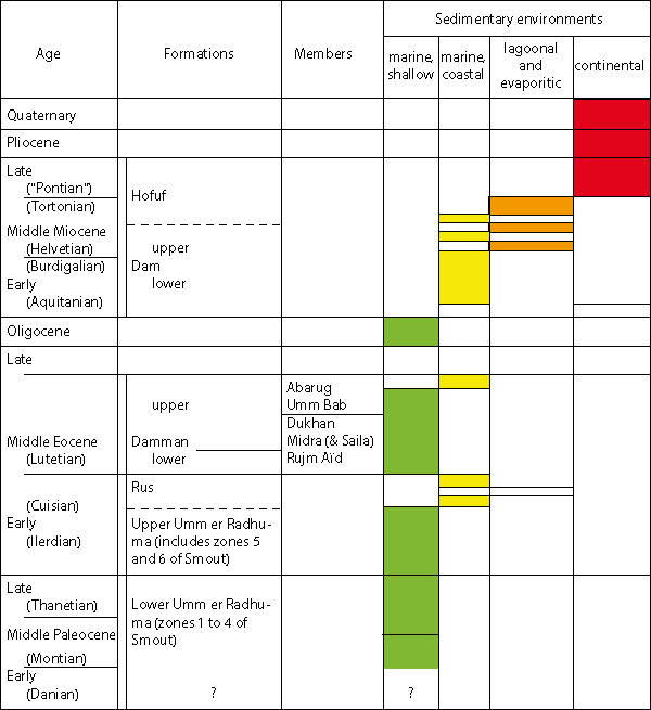
Table 1. Summary of the stratigraphic series of Qatar (Tertiary deposits).
The stratigraphic terms are listed according to their common English form. Those for which the use is obsolete are preceded by an asterisk.
|
Middle Eocene |
|
See: Dammam Formation, Upper Dammam Subformation.
|
Middle Eocene |
|
See: Dammam Formation, Abarug dolomitic Limestone and Marl Member.
|
Middle Eocene |
See: Dammam Formation, Dukhan Alveolina Limestone and Marl Member.
|
Paleogene |
|
See: Hasa Series.
|
Paleogene |
See: Hasa Series.
|
Lower Eocene |
See: Rus Formation.
|
Lower to Middle Miocene (?) |
Authors
M. and T.W., 1935, unpublished report, Saudi Arabia
Synonymy
See R.W., 1968, Lex. Strat. Intern., Saudi Arabia; C., 1970, Geol. Descr. Qatar
Definition
See R.W., 1968, Saudi Arabia; C., 1970, Qatar
Description
In Qatar, where the neogene transgression is late (absence of the Hadrukh Formation defined in Saudi Arabia), the first marine Miocene deposits lie unconformably on the Middle Eocene (Abarug Member but most of all Umm Bab). They are essentially preserved in either synclinal position or in collapse structures in the SW of the peninsula.
Often called Lower Fars [7] in old unpublished petroleum reports, referring to the Iranian series, the neogene deposits of Qatar were later correlated with the Dam Formation, and sometimes with the Hofuf of Saudi Arabia in the hydrogeological reports.
Unlike the Eocene deposits, the Miocene series vary rapidly from place to place and the strict application of the rules of lithological nomenclature would result in the proliferation of local terms.
Like our American colleagues of ARAMCO, we retained only one formational term for all deposits of alternating clay, marl and limestone of the marine Miocene of Qatar and avoided the creation of members.
In our view, the comparison of the Neogene deposits of Qatar with those of the Dam Formation of Saudi Arabia (type section in R.W., L.F., L.D. and E.L., 1966) justify the extension of the definition in Qatar. The Iranian "Lower Fars" however are partly composed of evaporites, which play particularly an insignificant role in the marine Miocene of the Qatar peninsula; it is only in the offshore area that the term is justified ( J. and K.F.L., 1965, confirmed by J., 1968).
The detailed study of the two complete sections in the SW of Qatar, near the border with Saudi Arabia, and of a partial section at the border, in Qarn Abu Wail, already studied by L.R. in (in P., 1936, p. 37), has allowed to define two subsets in the Dam Formation that were mapped throughout Qatar ( C., 1970):
LOWER DAM SUBFORMATION
This subdivision, which consists of alternating biogenic limestones, argillaceous limestones, marls or green clays formed from a mixture of illite, kaolinite, chlorite and smectite, is limited at the base by the last Eocene deposit and, at the top, by the last limestone level with abundant "Echinocyamus" (in fact Fibularia), forming a platform generally very cleaned by erosion. In the area of Abu Samra, this subdivision has a thickness of only 30 metres, but it tends to thin out slightly to the North and Northeast, while the argillaceous layers become progressively more calcareous.
Fauna
The molluscs are very abundant, but their identification has not yet been studied systematically: with Ostrea latimarginata Vredenburg, sometimes common, are also found Pectinidae, Anomia, Spondylus, Lima, Avicula ... and impressions and molds of Clementia papyracea (), Diplodonta, Chama gryphoides , Venericardia, Trachycardium, Veneridae ... and very locally some Cyrenidae.
The Gasteropods, generally found as impressions, include Fissurella, Natica, Xenophora, Turritella, Cerithidae, Cypraea, Conus, Bulla ... and very locally some Hydrobia, Potamides, and other brackish water genus.
The Echinoderms are very common but relate primarily to the species Fibularia voeltzkowi , characteristic of the sub-Formation.
The Bryozoa corresponds to species not yet described: Steginoporella (?) sp., Thalamoporella n.sp. 1 et n.sp. 2.
The fishes are not common: Aetobatus arcuatus and Diodon sp. indet., as well as some remains of Reptiles (?).
The algae are locally abundant: Halimeda eocenica .
Let's note finally the frequence of Crustacean remains and the abundance of Large Foraminifera of the genus Archaias. The corals occur very locally at the extreme base.
UPPER DAM SUBFORMATION
This subdivision has a very similar lithological succession, in detail, of that of the Lower Dam sub-formation: repeated alternations of thin beds of organogenic limestone, argillaceous limestone, marl and red, green and gray clays with, among others, some sandy episodes. The clay fraction is generally similar to that found in the Lower Dam, with a attapulgite fraction also common. Celestite clusters exist locally at the base.
The whole sub-formation varies rapidly in the detail from place to place. About 50 meters thick in the synclinal area of Abu Samra, the deposits of the Upper Dam decrease rapidly in thickness towards the N and NE, where they essentially become limestone.
At the base, the Upper Dam is limited by the last limestone bed of abundant Echinocyamus (Fibularia); at the top it ends under the first detrital or argillaceous level of the Hofuf Formation. In general the contact of the two formations is difficult to study because of the poor consolidation of the deposits of the Hofuf Formation.
Fauna
In the synclinal area of Abu Samra, the Upper Dam deposits display essentially marine features, with intercalations in the upper half, of organogenic limestones, with loads of Clausinella persica and locally some Hydrobiidae, indicating an environment abnormal in salinity. Towards the North and Northeast, these levels with Clausinella persica make up the major part of the sub-formation, here much thinner.
The Molluscs from the marine layers, where the Pelecypods predominate, include Chlamys senatoria (), Anomia sp., Ostrea latimarginata and impressions and molds of Clementia papyracea (). Capsa lacunosa (), cf. Capsa fragilis (), Tellina (Peronidia) bipartita , Diplodonta cf. rotundata (), Barbatia barbata (), Anadara cf. turonica (), Cardiocardita cf. monolifera (), Cardiocardita aff. turonica ( et ), Solenocurtus basteroti (), Timoclea (Venus) subspadicea (), Modiola (Amygdalum) sp., some Cardium, Lucina, Mactra, Tapes, Eastonia, Panopea ... The Gasteropods, represented by internal molds, belong to the genus Xenophora, Ampullina, Turritella, Cerithium, Cypraea, Cassis, Fasciolaria, Voluta, Conus, ? Olivella, Bulla ...
The Echinoderms are abundant at certain levels, but remain in part undetermined: towards the base Schizaster sp., Agassizia aff. persica and locally towards the top are abundant spines of Cidaris sp. 1 de 1901.
The Bryozoa are not very common, among them ? Cupuladria gr. haidingeri, as well as remains of fishes: Seoliodon (ou Physodon) sp.
The remains of Crustaceans are abundant in the carbonate rocks.
Age of the deposits of the Dam Formation
The fauna collected in the Dam Formation has not yet been fully studied, and if the Miocene age of the deposits appears beyond doubt one may hesitate between the Lower and Middle Miocene.
The known Molluscs are, for most, of little significance, however some have a distinct old character, such as Ostrea latimarginata Vredenburg, a widespread species in the Lower Miocene (Burdigalian) of india, Burma, Java ... and Timoclea (Venus) subspadicea (), the latter being limited to the Lower Miocene in Aquitaine.
Cidaris sp. 1, of which the spines are plentiful locally towards the top of the Upper Dam, in association with Chlamys senatoria and Ostrea latimarginata, has been described initially by from the Yenangyoungian (upper Pegu) in Lower Burma, and of which the assigned Lower Miocene age seems to raise little doubt.
The type of Fibularia voeltzkowi , characteristic of the Lower Dam, which comes from the Cyphus limestones of the Mahakamby island in Madagascar, is of a doubtful age, but it has also been found in the Fundi Isa Limestone of Kenya, attributed to the Lower Miocene.
The tooth of Aetobatus arcuatus indicates an age between Burdigalian to the end of the Miocene ; its size is very small, which would indicate according to either a juvenile form or a species at the beginning of its evolution.
Most other forms are of little significance, but note the presence in the upper Dam, of an association of molluscs classic of "Faluns de Touraine (France)" with a known Lower Helvetian age. These forms are for all identified on the basis of impressions and casts and are not very significant if taken separately; however, if taken together they give the deposits of the Upper Dam a character a little more recent than the Burdigalian.
In the neighbouring regions, R.W. , L.F. , C.D. and E.L. (1966) give a list of collected fossils in the Dam Formation of Saudi Arabia; according to them, the occurrence of Ostrea latimarginata Vredenburg, Echinocyamus sp. and Archias sp. indicate an approximate correlation with the Lower Fars of Iraq; on this basis, the Dam Formation is presumed to be dated Middle Miocene.
J. and K.F.C (1965), describing the offshore Miocene serie of Abu Dhabi and Qatar note the close lithological similarities between the Lower Fars of Iran[8] (occurrence of massive anhydrite). From a stratigraphic point of view, this announces the discovery of Taberina malabarica, a species "characteristic of the Burdigalian", in the limestones under the middle anhydritic serie.
The age of the Iranian Lower Fars is discussed and controversial (Burdigalian-Helvetian). With our current knowledge, it is not possible to attribute a different age to the Dam deposits of Qatar and the neighbouring countries, but it is likely that at least the Lower Dam is of Burdigalian age.
|
Middle Eocene |
Lower Dammam Subformation:
Upper Dammam Subformation:
Author Dammam Formation:
R.A. (1941, unpublished report, Saudi Arabia)
Synonymy:
See R.W., 1968, Lex. Strati. Intern., Saudi Arabia; C., 1970, Geol. Descr. Qatar
Definition
See R.W., 1968, Saudi Arabia; R.P., 1967, Bahrain ; C. 1970, Qatar
Description
The deposits composing the Dammam Formation cover about 80% of the surface of the Qatar Territory.
The Dammam Formation is divided in members in Saudi Arabia and Bahrain; in Qatar, the used terminology is somewhat different, although it covers a very similar lithostratigraphic succession. (see table P. 101).
In Qatar, the subdivisions of the Dammam Formation have been regrouped in two sets ( C., 1970): the Lower Dammam Subformation which includes the three lower members (Rujm Aïd, Midra (Saila), Dukhan), and the Upper Dammam SubFormation composed of the Umm Bab and Abarug members.
Lower Dammam Subformation
The outcrops of the Lower Dammam SubFormation are comparable in their distribution to those of the Rus Formation. The nature of the deposits is very constant, but their thickness varies considerably, maximum (8 to 10m) at the extreme south in the area of Sauda Nathil, medium in Jebel Dukhan (5 to 6 m), it diminishes in the Northeast of Qatar where the deposits disappear in the sector Khor, Al Mazidah, Sinnah.
|
Saudi Arabia |
Bahrain |
Qatar |
| Sommet | ||
| (Alat Limestone) | White Limestone | (Abarug dolomitic |
| Limestone) | ||
| Alat Member | Abarug Member | |
| (Alat Marl) | Orange Marl | (Abarug dolomitic |
| Marl) | ||
| Khobar Member | Brown crystalline | Umm Bab Member |
| Limestone | ||
| Alveolina Limestone | (Alveolina zone) | |
| Member | Shark Teeth Shale | Dukhan Member |
| Saila Shale Member | ||
| Midra (and Saila) Member | ||
| Midra Shale Member | ||
| Rujm Aïd Member | ||
| Base |
Tableau 2. The Dammam Formation: subdivisions in Saudi Arabia, Bahrain and Qatar.
A reference section has been measured in Qatar in Jebel Dukhan, 1km east of the installations of Q.P.C., in Fhaihil ( C., 1970):
Rujm Aïd Velates limestone Member.
This member was defined by C. (1970) under the name of "Fhaihil Velates limestone Member". But this term, homonymous with an Upper Jurassic Formation of the petroleum geologists, was abandoned and replaced here for the first time with "Rujm Aïd Velates limestone Member".
In the reference section this member is made of a crystallines, compact, hard fossiliferous whitish limestone of 1.2m thick. It lies on the Khor Limestone Bed of the top of the Rus Formation (see p. 111) and is overlain by the Midra (et Saila) Shales
With its marine fauna and its lithological type, the Rujm Aïd Velates limestone cut perfectly on the Khor Limestone underneath; it is however very comparable to the Umm Bab Limestone of the Upper Dammam SubFormation. It has been recognized all over Qatar, with the exception of the Northeast. In Saudi Arabia, where it has not been formally recognized, N.J. (1962) and R.W. (1968), have pointed it at the base of the Midra Shale Member
The fauna is characterised by the more or less great abundance of Molluscs and in particular by the small size Velates schmiedeli (). We found as well internal casts of Gisortia gigantea (), Terebellum, Pleurotomaria ... and impressions of Pelecypods, including Glycimeris cf. jacquoti () var. nobilis in , Cardium ... and fragments of Pectinidae and Ostreidae.
The Foraminifera discovered include Dictyoconoides cf. koaticus (), Lockhartia conditi (), Rotalia cf. trochidiformis () and an old form of Nummulites discorbinus ().
Midra (and Saila) Shales Member
The Midra (and Saila) Shales Member is made up of attapulgitic shales, generally brown to green on outcrops, containing pseudomorphs of pyrite in hematite, with one or several intercalations of limestones more or less phosphatic apparently discontinuous. The whole is irregularly fossiliferous and is 5m thick at the reference section of Fhaihil, but can reach 8 metres in the extreme south and not be present in the North east.
In Saudi Arabia the Midra Shales (s.l.) were subdivided late in time in two members: Midra Shales (s.s.) at the base, Saila Shales at the top. This distinction, based mainly on the color of the shales, was not retained in Qatar, where we have introduced a composite term to remember the similarity with Saudi Arabia ( C. 1970). The fauna of the Midra (and Saila) Shales is quite varied and include rare branched Bryozoa, indeterminable (Membraniporide ?), some Echinoderms: numerous spines and locally a deformed species referred temporarily to cf. Linthia navillei de . The Molluscs are very common in the shales and the carbonate intercalations, their determination however is not well advanced. The most common species in the upper half of the shales is Cubitostrea multicostata () var. strictiplicata et (=2 Ostrea turkestanensis ), the Amussium and the Vulsella are locally abundant. In the upper shales, the internal casts in hematite, more or less deformed, belong among others to Lucinidae, Corbulidae, Crassatellidae, Veneridae, Cardiidae, Carditidae ... Towards the base is noted among others the occurrence of Teredo, Lithocardium sp., Chama sp., Bicorbula sp. and of Phacoides cf. squamula
The Gasteropods are very few and represented in the shales by Turritella, Natica, Terebellum, Athleta, Turricula, Acteon, ...
The calcaro-phosphatic intercalations contain Pycnodonte archiaci (), Pseudomiltha cf. gigantea (), Pseudomiltha sp., Trachycardium gr. porulosum (), Chama sp., Venericardia sp., some Ostrea and some Pectinidae. The Gasteropods are represented by Velates schmiedeli (), Campanile sp., Gisortia gigantea (), Gisortia sp., Mitra sp., Bulla sp. ...
The ichtyofauna is very abundant in the shales: E. (1971) has given a detailed description, where 28 types are recognized. It is mainly the Elasmobranchs that prevail, and among them the Lamniformes and the Carcharhinides. The presence of the genus Galeocerdo, which appear only after the Ypresian, and of Lutetian species of the Tethys, such as Lamna gafsana , Propristis schweinfurthi, Sphyraena fajumensis (), Pycnodus mokattamensis ... is particularly interesting, since most of these types have been encountered in the lower half of the Midra (et Saila) Shales
The Large Foraminifera are sometimes common in the shales (Dictyoconoides kohaticus () especially), but are abundant especially in the calcaro-phosphatic intercalations: Nummulites discorbinus () var. minor de la , N. aff. discorbinus (), N. cuvillieri , Dictyoconoides kohaticus (), Alveolina elliptica nuttali.
Dukhan Alveolina Limestone Member
The Dukhan Alveolina Limestone Member has been recognized since long time ago in Qatar under various names: "Alveolina Bed" ( and , unpublished, 1938), "Middle Eocene Alveolina Limestone" (, 1954) ... Composed of a bed of white to yellowish limestone more or less argillaceous, not very thick (0.60 m in Fhaihil), which sometimes splits in two, it is intimately linked to the Midra (and Saila) shales, at the base, and progressively merge with the marls at the base of the Simsima [Umm Bab] limestone, at the top. Its thickness rarely reaches one metre but it is an excellent marker because of its extreme abondance in Alveolina. It can be observed all over Qatar except in the NE region.
The fauna includes rare Bryozoa: Sertella sp., some small Echinoderms similar to the Echinocyamus, some Molluscs, common mostly at the base and at the top, in the more argillaceous beds. The Ostreidae and locally the large Vulsella are quite common, the Pectinidae are fairly rare. The Gasteropods (molds) are mainly occurring at the top: Conus, Bulla, Terebellum, large Ampullospira ... A Nautilus exists as well at this level. The remains of fishes are quite rare (Shark teeth and Pycnodus cf. mokattamensis ). The Large Foraminifera are obvious by the extreme abundance of Alveolina elliptica var. flosculina ; Linderina buranensis ( et ) is abundant; Nummulites discorbinus () occurs; the Dictyoconoides and Dictyoconus are rare.
Upper Dammam Subformation
Represented by much thicker deposits as those of the Lower Dammam, the outcrops of the Upper Dammam cover the major part of the surface of Qatar, but the details of the layers remain unclear in the absence of good sections. The thickness of the most complete series does not seem to exceed 50 metres.
In most part of Qatar, the deposits of the Upper Dammam overlie continuously those of the Lower Dammam; but in the NE of Qatar, they are directly overlying the Khor limestone (the limestone bed at the top of the Rus Formation) or on the underlying soft white limestones of the same formation (see Rus Formation).
Umm Bab Dolomite and Limestone Member
This member was defined by C. (1970) under the name of "Simsima Dolomite and Limestone Member " which corresponds to the "Simsima Chalk Member" (or "Simsima Chalks ») and to the "Surface Dolomite Member" defined by , 1959, in an unpublished report: "The fresh water supplies of Northern Qatar". But since the term is homonymous with a maestrichtian formation used by the petroleum geologists, it had to be abandoned, and substituted here for the first time by "Umm Bab Dolomite and Limestone Member".
had noticed in the NE of Qatar the fairly constant overlapping of a dolomitized horizon to white crystalline limestones, and thus recognized two members. The study of the more complete sections in western Qatar show that when the upper members of the Middle Eocene are preserved (Abarug Member), the whole of the underlying levels is made up of white crystalline limestones and that no dolomitic intercalation exists similar to the "Surface Dolomite": the latter seems to be the consequence of a superficial epidiagenesis of the top of the Umm Bab limestone and cannot be used in the recognition of a member.
The Limestone and the Dolomite of Umm Bab correspond to the Upper Limestone Group used by the first petroleum geologists who studied Qatar ( T.P., and R., unpublished report, 1938), a term which has not been retained.
Let's note as well the mention by (1959), of "Red Bed", towards the top of his "Simsima Chalks", a dolomitic horizon used as marker, probably detected while drilling, and that we have not identified formally.
In short, the Umm Bab Member is defined here (see Simsima Member, C., 1970) as the layers sandwiched between the Dukhan Alveolina Limestone Member and the dolomitic marls of Abarug. It has not been possible to study it in detail in a complete section. The base is commonly marly (attapulgite) and very fossiliferous (from 0 to 2 or 3 metres). Its overall composition is of a compact crystalline white limestone, with local layers of chert and red attapulgite; some hard brownish dolomite are irregularly developed in the upper half in the absence of a more recent cover. The total thickness is not accurately known, but certainly variable (estimated between 30 to 50 metres)
The fauna is essentially represented by Molluscs: Ostreidae, among which Pycnodonte archiaci (), Vulsella and Pectinidae are mainly represented in the basal marly layers, with molds and impressions of Lucina and Venericardia and molds of Gasteropods, among which Velates schmiedeli (), Gisortia, Terebellum, Ampullospira, Turritella, Conus, Acteon, Bulla ... In the bulk of the limestone beds, the fauna of Molluscs is fairly homogenous, with an obvious predominance of Gasteropods: Velates schmiedeli (), Gisortia gigantea (), Gisortia sp., Terebellum, Ampullospira, Natica, Campanile, Turritella, Xenophora, Rostellaria ... The Pelecypods are represented by fairly rare Ostreidae, among which Pycnodonte archiaci (), as well as impressions of Trachycardium gr. porulosum ().
The Echinoderms are common in the upper half: Echynocyamus polymorpha ( et ), Porocidaris aff. schmiedeli (), and especially at the top, where they make up large deposits on the western coast of Ras Abarug, with: Porosoma aff. lamberti , Echinocyamus polymorpha ( et ), Echinolampas perrieri de , Oppisaster derasmoi , Schizaster beloutchistanensis (d'), Eupatagus formosus de .
The Large Foraminifera observed in the basal marly layers belong essentially to the species Dictyoconoides cooki (), and sometimes to Nummulites discorbinus ().
When the first limestone beds begin, Dictyoconoides cooki becomes rare while Nummulites discorbinus is now more abundant, in association with Alveolina elliptica , generally not common, and with Linderina. In the chalky crystalline limestones appear, immediately at the base, the first small size species identified as Nummulites beaumonti d', in association with Nummulites discorbinus major .
In the upper levels, the Nummulites become rare and isolated and belong to the species Nummulites beaumonti d' and Nummulites somaliensis et , in association with Dictyoconus daviesi Silvestri, Alveolina cf. elliptica and Alveolina cf. delicatissima .
Towards the top, in the Echinoderm layers of Ras Abarug, only few rare Nummulites beaumonti d'Arch and a granular Nummulite of the phyllum Nummulites fabianii (comparable to Nummulites bullatus Azzaroli) have been observed.
Abarug Dolomitic Limestone and Marl Member
The Abarug Dolomitic Limestone and Marl Member has been named very early in Qatar: in 1938, and R. defined, in a report which remains unpublished, the "Abaruk Beds", subdivided in "Abaruk Chalk" at the base and "Abaruk Bed" at the top. These terms were used again by subsequent authors who have worked in Qatar, especially the hydrogeologists, but I had to slightly modify the form (and orthograph) after detailed study of the outcrops of Ras Abarug ( C., 1970).
A reference section surveyed 3 kms South of Bir Zekrit, in the Ras Abarug Peninsula, shows two units, that are found everywhere in Ras Abarug: at the base, resting on the crystalline limestones of Umm Bab, a set of dolomitic marls and soft, but compact, argillaceous dolomite, yellow-orange to green, nodular at the top, of a fairly constant thickness (10.40 m in Bir Zekrit), called Abarug dolomitic Marl; at the top, an irregularly dolomitized limestone, changing frequently to a calcareous dolomite (or not), greyish yellow to brown, hard, which has become cavernous by the abundance of impressions and molds of Molluscs, generally not too thick in Qatar (about 2 metres) called Abarug dolomitic Limestone.
The deposits of the Abarug Member are not only in the occidental part of Qatar ; typical to the NW in the Ras Abarug Peninsula, they also occur close to the coast, occasionally between Dukhan and Umm Bab, and in the SW under the Miocene, where they are very little or not fossiliferous and of a reduced thickness. There is no proof of their initial extension over Qatar, but it is certain that in Western Qatar they went through a differential erosion during the period of continental evolution corresponding to the Upper Eocene, the Oligocene and the base of the Miocene.
The fauna of the Abarug dolomitic Marl is restricted to badly defined Mollusc impressions observed in the nodular level at the top. The Abarug dolomitic Limestone is rather rich in Mollusc impressions and molds more or less determinable belonging to Pectinidae, Spondylus, Lima, Mytilus, Barbatia, Arca, Lucina, Venericardia, Chama (Chama cf. calcarata ), Cardium, ? Sinodia, Corbula (Cicorbula), Teredo ... The gasteropods are represented by Cerithidae, Volutidae, Bullidae, Trochidae, Turbidae, associated with Lyria, Turritella, Natica. A large form seems to correspond to (?) Voluta bericorum and the tubes of Magilus grandis are common. The Echinoderms are rare: Echinolampas fraasi de , as well as the large Foraminifa: Dictyoconoides cooki () (1 sample).
In Bahrain, the same level has provided at Jebel Hisai (, L.R., 1936), other than Echinolampas sp.: Terebellum carcassense , Mytilus cleopatrae , Spondylus radula, Lucina (Loripinus) pharaonis , Chama calcarata , Corbula (Bicorbula) subexarata d'.
Age of the deposits of the Dammam Formation
The geologists who studied the Dammam Formation in Qatar ( A.H., 1954 ; C., 1970) or in Saudi Arabia ( N.V., 1962 ; R.W., 1968) included the Midra (and Saila) Shales in the Lower Eocene, due essentially to the presence of a small Nummulite determined as Nummulites "globulus" by A.H. as well as by N.V. This small form, studied in detail by A. (to whom I had communicated to come from the Lower Eocene), is in fact different from the true globulus and is close to the phyllum of Nummulites discorbinus, and is very close to the minor variety.
Another element put forward by N.J. (1962) is based on the presence of an oyster called "Ostrea turkestanensis" in the Midra (and Saila) Shales. Like L.R. (1936), I had kept this determination for the Midra (and Saila) Shales oyster, but after a detailed review of this species, it became impossible to distinguish it from Ostrea multicostata var. strictiplicata ( R., 1938 had also come back to this interpretation for the form coming from Bahrain). This oyster, that is both Ypresian and Lutetian, can not be an element of accurate dating. Similarly, E., to whom I had communicated my ichthyological samples from the Midra and Saila Shales as coming from the Ypresian, was forced, in the presence of the material, to invalidate this dating, noting that, as early as the lower part of the Midra Shales, he observed the existence of the genus Galeocerdo, which appears only after the Ypresian, associated with species from the Lutetian of the Tethys, and that among the forms which appeared as early as Lower Eocene, none pertained to the latter.
The only Echinoderm, determined provisionally by F.J., coming from the Midra Shales is one of cf. Linthia navillei de , a form "from the Lower Eocene towards the limit with the lower Lutetian".
It makes no doubt, after considering these determinations, that no form typically Ypresian exist in the main deposits of the Lower Dammam, which shows, instead, already some good Lutetian species. It is nonetheless true that the examination of the evolutionary stages of Nummulites discorbinus from the Velates Limestones of Rujm Aïd and of Midra (and Saila) Shales indicates the start of a phyllum ; the type characterises the Middle and Upper Lutetian, its seems logical, as much from the degree of evolution of the Nummulites than the whole faunal assemblage, to attribute these members to the Lower Lutetian.
The Dukhan Alveolina Limestone was also reported by N.J. to the Ypresian, on the basis of the determination of Alveolina "subpyrenaica". However A.H. (1954), attributing this form to Alveolina elliptica var. flosculina, linked this member to the Middle Eocene. The determination has been confirmed by A.
On the basis of the determined microfauna, both Alveolina elliptica and the Linderina tend to give an Upper Lutetian age, by comparison with the mediterranean regions or the Paris Basin, but eastwards Alveolina elliptica is classic in the Indian Middle Kirthar, that L. (1971) assigns to the lower part of the Lutetian. On the basis of the degree of evolution reached by Nummulites discorbinus and taking into account the observations from L., the Dukhan Alveolina Limestone seems similar, approximately, with the Middle Lutetian of the Paris Basin. The Umm Bab dolomitic and limestone Member, from the point of view of the whole faunal assemblage, Molluscs and mostly Echinoderms and Large Foraminifa, belongs to the Upper Lutetian.
The Abarug dolomitic Marl and the Abarug dolomitic Limestone have offered few determinable species; the Molluscs from Bahrain show a Middle Eocene age, according to L.R. (1936) ; Echinolampas fraasi is a Middle and Upper Eocene form (not encountered in the underlying Umm Bab Limestones); the rare known Large Foraminifa: Dictyoconoides cooki, in Qatar, and one large Dictyoconus, in Saudi Arabia, mentioned by R.W. (1968), would rather assign these levels to the Upper Lutetian.
From the point of view of the whole faunal assemblage, and since no typical Upper Eocene form have been collected, the Abarug dolomitic Marl and the Abarug dolomitic Limestone seem to still belong to the Upper Lutetian.
|
Middle Eocene |
See: Dammam Formation, Lower Dammam Formation.
|
Middle Eocene |
See: Rujm Aïd Velates, Limestone Member.
This term, created by C. (1970), to designate a bed at the base of the Dammam Formation, Middle Eocene, is homonymous with the one formally defined by W., in 1959, for an Upper Jurassic formation. So it is replaced, in this Lexicon, by Rujm Aïd Velates Limestone Member, from the name of a locality near Fhaihil, located between Dukhan and Umm Bab.
|
Paleocene-Eocene |
Author
N.J. (1951 ; unpublished report, Saudi Arabia)
Synonymy
See R.W., 1968, Lex. Stratigr. Intern., Saudi Arabia; C., 1970, Geol. Descr. Qatar.
The terms Bahrain Group or Bahrain Formation (, 1940), previously used in Qatar, but which remained unpublished, are currently abandoned.
Definition
( N.J., 1962): "The units of Eocene age (Paleocene included) in the western areas of the Persian Gulf, are designated under the term Hasa Series, from the name of the Hasa Province, where they outcrop".
Subdivisions
In eastern Saudi Arabia, in Qatar, in Bahrain and in Abu Dhabi, the Hasa Series is divided in three formations, from the oldest to the youngest: Umm er Radhuma Formation, Rus Formation, Dammam Formation.
|
Upper Miocene ? to Pliocene ? |
Authors
M. and T.W. (1935, unpublished report, Saudi Arabia)
Synonymy
see R.W., 1968, Lex. Strati. Intern., Saudi Arabia; C., 1970, Geol. Descr. Qatar.
Definition
see R.W., 1968 ; C., 1970.
Description
Defined in Saudi Arabia, the Hofuf Formation is represented in the SW of Qatar, where it caps some outliers made up of deposits from the Dam.
This term has been introduced in the geological literature dedicated to Qatar by the hydrogeologists, from whom the reports remain unpublished, and has been used again by C. (1970). No complete section has been surveyed in the deposits of the Hofuf Formation in Qatar. From partial sections, the base appears often made of red and green clay, more or less sandy, or of bulky sands and sandstones.
The main body is composed of sand, gravels and pebbles (quartz, jasper, crystalline rocks, limestones, ...), from a probable Saudi Arabian origin. The thickness of the deposits, generally non-fossiliferous, does not seem to exceed 10 metres in Qatar.
In the NE of Khararah, the Gurain Al Balbul is capped by conglomerates with locally, at the base, a calcareous fossiliferous cement (?): abundant Clausinella persica (opened form, with hinge), associated with badly preserved small gastropods (Cerithidae ?). A shell fragment, with an ornementation characteristic of a form from the group of Timoclea ovata () (Timoclea cf. subspacidae ), has also been found.
This small fauna shows certain affinities with the deposits of the Upper Dam (almost absent at Gurain Al Balbul) but it is difficult to know if the conglomerates correspond, in this extreme point of the extension of the Miocene deposits preserved in this sector, to a facies of the Upper Dam, if they have altered almost on location the sediments of the Upper Dam or if the small fauna previously mentioned is contemporaneous to the Hofuf Formation (in the original sense of the term).
At the regional scale, in Qatar, the deposits of the Hofuf Formation rest on a serie more and more reduced of the Upper Dam and at the extreme over the deposits of the Lower Dam, when one gets away from the Abu Samra area towards the North or Northeast. This observation can be interpreted as the proof of a regional unconformity between the deposits of the Dam and the Hofuf or as a lateral facies variation of the Upper Dam deposits.
The age of the base of the deposits, at Gurain Al Balbul, is very likely Miocene; elsewhere, in the absence of fauna, we can only use the interpretation given by R.W.: Upper Miocene or Mio-Pliocene.
|
Lower Eocene |
See: Rus Formation.
|
Middle (?) Miocene |
See: Dam Formation.
|
Lower Eocene |
See: Dam Formation.
|
Paleocene–Lower Eocene |
See: Umm er Radhuma Formation.
|
Middle Eocene |
See: Dammam Formation, Dukhan Alveolina Limestone Member.
|
Middle Eocene |
See: Dammam Formation, Midra (and Saila) Shales Member.
|
Middle Eocene |
See: Dammam Formation, Lower Dammam Subformation.
|
Middle Eocene |
See: Dammam Formation, Umm Bab Dolomite and Limestone Member.
|
Lower Eocene (Cuisian) |
Author
R.A. (1946, unpublished report, Saudi Arabia)
Synonymy
See R.W., 1968, Lex. Strati. Intern., Saudi Arabia; C., 1970, Geol. Descr. Qatar.
The Chalk Zone (or Chalky Zone) term used previously in Saudi Arabia and the one of Lower Limestone Group, which included at the top the Midra Shales (s.l.), used in Qatar ( J.F. and R., 1938 ; R.V., 1949), have remained unpublished ; the latter is abandoned since 1956 ( W.)
Definition
See R.W., 1968 (Saudi Arabia) ; R.P., 1967 (Bahrain) ; C., 1970 (Qatar).
Description
In Qatar, only the upper part of the Rus Formation deposits outcrops, in the Jebel Dukhan (west coast), near Sauda Nathil (extreme south) and in the Northeast of the peninsula (Khor, Simsima, NW of Doha).
The top part is made of a bed of a greyish, granular limestone, with medium hardness, sometimes with secondary dolomitisation, often fossiliferous (impressions and molds of Corbula and Cerithidae), represented unevenly in all the zones of Qatar where the Rus outcrops; its thickness seems fairly uniform (0.80 to 1 m). This level has been assigned as the marker for the Khor Limestone Bed ( C., 1970).
A reference section of the visible deposits of the Rus (about 30 m) has been studied in detail and measured in Jebel Dukhan, 1 km East of the Q.P.C installations, in Fhaihil ( C., 1970). The Rus deposits, in Fhaihil, are essentially composed of limestones more or less dolomitized, soft, generally whitish, with minute argillaceous intercalations and green to brown dolomitic marl. Some harder greyish limestone beds, generally dolomitic, intercalate and are the only fossiliferous levels. Towards the base of the section can be observed some rare silica occurrence of the type "sugar candy" and "loaves" that evoke the existence of former levels or gypsum lenses. West of Dukhan, towards the visible base of the Rus, is seen a soft, whitish level of Limestone, with numerous quartz geodes. Celestite nodules have been encountered in the Khor area, as well as asphalt near Simsima, towards the top of the formation.
The study of some clays or marls from the Rus, in Fhaihil, has shown the irregular abundance of the dolomite, associated with quartz and halite; the clay fraction is dominated by micaceous minerals (illite) and contains some secondary smectites. A sample has shown the presence of attapulgite. Kaolinite has not been detected.
In some wells located in synclinal position, the Rus has significant intercalations of gypsum or anhydrite in its central part, similar to those known in Saudi Arabia ( R.W., 1968).
The absence or strong reduction of the evaporite levels has been noted in the north of Qatar: it can be attributed firstly to the anticlinal position of the area (restricted sedimentation rate), secondly to the effects of subsequent dissolution, evidenced by the abundance of "collapse-structures" on the surface.
The base of the Rus, known only in wells, seems very comparable lithologically to the soft whitish limestones of the top.
The total thickness of the Rus deposits varies ; the minimal known thickness is 28 m at Latariyah, NW of Doha, in anticlinal position. In the sector affected by the Simsima Dome (NE Qatar), it varies from 30 to 45 m. In synclinal position, the Rus is a lot thicker (84 m in Doha). In offshore it reaches 112 m in Idd-el-Shargi.
Fauna and age
The fauna of the outcropping upper part of the Rus is generally localised and not very abundant, in Qatar, essentially in the fairly hard, greyish dolomitic limestone beds, which intercalate in the soft whitish limestones that make up the top part (Khor Limestone Bed).
Only the Molluscs impressions and molds, often abundants, but little diversified, were recognized: Cardium sp., cf. Cuneocorbula, small Veneridae ? and especially Cerethidae, such as Trypanaxis cf. daviesi .
The type of the latter form comes from the Lower Chharat Beds of the Kohat District in India (, 1938). This formation which displays several common points with the Rus and in particular some evaporites, is intercalated between the Shekhan Limestone, recognized as an equivalent to the most upper Laki and the Kohat Shales at the base of Kirthar. Most often, the Lower Chharat Beds are classified in conjunction with the Lower Kirthar (at least the basal part) and attributed as such to the extreme base of the Middle Eocene.
However the review, on the basis of the known age of the Alveolina as much for the Laki than for the Middle Kirthar, the first positioned in the Middle to Upper Ilerdian, the second (levels of Alveolina elliptica) positioned in the lower part of the Lutetian ( C. [L.], 1971), leads to place both the Lower Chharat Beds and the Lower Kirthar in the Upper Ypresian (Cuisian).
In Qatar we get a similar age for the Rus deposits intercalated between the top of the Umm er Radhuma, equivalent to the Laki, and the base of the Dammam, attributed to the lower Lutetian because of its fauna.
See: Dammam Formation, Midra (and Saila) Shale Member.
|
Middle Eocene |
See: Dammam Formation, Midra (and Saila) Shale Member.
|
Middle Eocene |
See: Dammam Formation, Umm Bab Dolomite and Limestone Member.
|
Middle Eocene |
See: Dammam Formation, Upper Dammam Subformation.
This term, adopted by C., 1970, according to , 1959, to designate the lower part of the Upper Dammam Subformation, Middle Eocene, is homonymous with a formation name used by the petroleum geologists, and mentioned by H.V. in Lexique Stratigr. Intern., fasc. Iraq (1959, p. 239) and in J. Inst. Petr., 1967, 53 (520), pl. I, as well as by J.R., 1965, in 5th Arab Petr. Congr., Le Caire, for a Maestrichtian formation. Therefore, C. offers to replace it here with the term Umm Bab dolomite and Limestone Member.
|
Middle Eocene |
See: Dammam Formation, Umm Bab Dolomite and Limestone Member.
|
Paleocene–Lower Eocene |
Authors
S.B. and A.B., 1935 (unpublished report, Saudi Arabia)
Synonymy
See R.W. , 1968, Lex. Strati. Intern., Saudi Arabia; C. , 1970, Geol. Descr. Qatar.
The terms "Lower part of the Bahrain Formation" (, 1940) and "Busaiyir Formation" ( W., 1953), previously used in Qatar, have remained unpublished and abandoned since 1956 ( W.)
Definition
See R.W., 1968 (Saudi Arabia)
Description
In Qatar, the deposits of the Umm er Radhuma do not outcrop, but have been penetrated by many wells whether in Jebel Dukhan or in northern or central Qatar.
They are also known offshore. Their thickness is generally greater than 300 metres. They are essentially made of dolomites and limestones with different hardness, often fractured, with chert beds, and intercalations of marls and clays.
Fauna and age
In Qatar, only the Umm er Radhuma Formation microfauna has been systematically described, by A.H. (1954), who recognizes two assemblages, one, upper, assigned to the Lower Eocene, the second Lower, divided in 6 "regional" zones, corresponding to the Paleocene.
According to R.W. (1968), only 3 large subdivisions can be recognized in the Umm er Radhuma of Saudi Arabia and Qatar, of which the lowest 2 correspond to the Paleocene, the upper falling under the Lower Eocene age.
The lower subdivision of the Paleocene (=2 zones 1 to 4 of ) contains in Qatar: Kathina delseota , Daviesina Khativahi , Lockhartia altispira , L. conica , L. prehaimei , Asterigerina dukhani , Rotalia hensoni , R. dukhani .
The upper subdivision of the Paleocene (=2 zones 5 to 6 of ) contains : Miscellanea miscella (d' et ) var. dukhani , M. meandrina () and Operculina sp. The genus Miscellanea is considered by as limited to this subdivision.
The basal Lower Eocene (=2 Lower Eocene of A.H. ) is characterized by Sakesaria cotteri , Lockhartia tipperi () and L. hunti var. pustulosa .
Recently,(1970) has subdivided the Umm er Radhuma Formation in eastern Saudi Arabia in 9 zones ; from top to bottom :
According to this author, planktonic Foraminifera coexist with the Large Foraminifera in the Discocyclina redmondi zone, allowing a direct correlation with the Globorotalia pusilla pusilla zone and the lower part of the Globorotalia pseudomenardii zone of (1957).
According to these data we could put forward a rough equivalence of the D. redmondi zone of with the English Thanets Sands, that Berggren places up against the same zones, as well as with the Heersian and the base of the Belgian Landenian ().
These possible equivalences with the western Europe stratotypes do not allow to automatically infer, as suggested by , that the O. qatarensis and M. miscella zones are of sparnacian age: the English Thanets Sands do not indeed cover the upper part of the known Thanetian of the belgo-parisian basins. Moreover, the agreement is not perfect regarding the equivalence of Thanets Sands with the zones of planktonic Foraminifera; therefore , , and consider that it would not be plausible to place this formation below the Globorotalia parva zone of Szots (which corresponds to the Globorotalia "velascoensis" zone of ).
A.H., moreover, correlates the upper part of the Umm er Radhuma, which he assigns to the Paleocene, with the indian Ranikot. The terminal part, assigned to the Lower Eocene, is placed in parallel with the Laki.
N.J. (1962) admits also a correlation between the top of the Umm er Radhuma, characterized by Lockhartia tipperi and Sakesaria cotteri, with the indian Laki. However, the whole lower levels would correspond only to the upper Ranikot.
In fact, if we leave out the Cardita beaumonti layers, of questionable age, but probably all or part danian according to the planktonic Foraminifera, and the much localized deposits of the Pondichery Formation and similar to the south-east coast of the indian peninsula, the marine serie starts in India with the Upper Ranikot. This formation contains Large Foraminifera, among which Miscellanea miscella and M. meandropsina, known only in the upper assemblage of the Umm er Radhuma of Qatar (and Saudi Arabia), assigned to the Paleocene (zones 5 and 6 of A.H. and upper subdivision of the Paleocene of )
It is remarkable also that all forms encountered in the lower assemblage of the Umm er Radhuma, with the exception of species of wide distribution that continue through the upper assemblage, such as Lockhartia conditi, had to be considered by both A. H. and N.J. as new. Very detailed studies on the indian Large Foraminifera having been initiated much before the works of A.H. and N.J. , we can conclude that the base of the Umm er Radhuma is most likely older in whole or in large part to the Upper Ranikot. The latter formation would be represented in Qatar approximately by zones 5 and 6 of A.H. , and the Laki, by the top of the Umm er Radhuma with Lockartia tipperi and Sakesaria cotteri.
Recently L. (1971) examined the Alveolina from the Upper Ranikot and from the indian Laki for their lateral equivalents. He concludes that a correlation exists between the Upper Ranikot and the lower Ilerdian Pyrenean and between the Laki and the middle to upper Ilerdian.
The exact correlation between the pyrenean Ilerdian with the classic nortwestern European series has not been established, however almost all the authors currently agree for a correlation with the lower Ypresian (Sparnacian + basal Cuisian)
In conclusion, the age of the lower part of the Umm er Radhuma (zones 1 to 4 of A.H.) is very likely Paleocene (undifferenciated, maybe only at the top).
Zones 5 and 6 of A.H. and his upper zone with Sakesaria cotteri and Lockhartia tipperi correspond most likely, respectively, to the lower Ilerdian and to the middle to upper Ilerdian; they must be approximately positioned in regards to the basal Lower Eocene (Lower Ypresian vel "Sparnacian") of Northwest Europe.
|
Middle Eocene |
See: Dammam Formation, Umm Bab Dolomite and Limestone Member.
Chronological index of commonly used stratigraphic terms (C. 's memoir, 1970)
|
Paleocene – Middle Eocene |
Hasa Group | |||
|
Paleocene – Lower Eocene |
Umm er Radhuma Formation | |||
|
Lower Eocene |
Rus Formation | |||
|
|
|
|
|
Khor Limestone Bed |
|
Middle Eocene |
Dammam Formation | |||
|
|
|
Lower Dammam Subformation | ||
|
|
|
|
Rujm Aïd Velates Limestone Member | |
|
|
|
|
Midra (and Saila) Shale Member | |
|
|
|
|
Dukhan Alveolina Limestone Member | |
|
|
|
Upper Dammam Subformation | ||
|
|
|
|
Umm Bab Dolomite and limestone Member | |
|
|
|
|
Abarug Dolomitic Limestone and Marl Member | |
|
|
|
|
Midra shales Member, Saudi Arabia | |
|
|
|
|
Saila Shales Member, Saudi Arabia | |
|
|
|
|
Abarug Dolomitic Marl and Limestone Member | |
|
Miocene |
Dam Formation | |||
|
? Lower Miocene |
|
Lower Dam Subformation | ||
|
? Middle Miocene |
|
Upper Dam Subformation | ||
|
Upper Miocene |
Hofuf Formation | |||
Chronological index of obsolete stratigraphic terms (C. 's memoir, 1970)
|
Paleocene - Eocene |
Bahrein [Bahrain] Formation | |
|
(Hasa Series) |
Bahrein [Bahrain] Group | |
|
Paleocene – Lower Eocene |
Lower Part of the Bahrein [Bahrain] Formation | |
|
(Umm er Radhuma Formation) |
||
|
Lower Eocene |
Chalk (y) Zone | |
|
(Rus Formation) |
Lower limestone Group | |
|
Middle Eocene |
| |
|
(Dammam Formation) |
| |
|
(Rujm Aïd Member) |
|
Fhaihil Velates Limestone Member |
|
(Dukhan Member) |
|
|
|
|
|
Middle Eocene Alveolina Limestone |
|
(Midra Shale Member) |
|
Midra Shales (s.l.), Saudi Arabia |
|
(Umm Bab Member) |
Upper limestone Group | |
|
|
|
Simsima Dolomite and Limestone Member |
|
|
|
Simsima Chalk Member |
|
|
|
Surface Dolomite Member |
|
|
|
Red Bed |
|
(Abarug Member) |
|
|
|
|
|
Abaruk Chalk |
|
|
|
Abaruk Bed |
|
Miocene |
| |
|
(Gachsaran, Iran) |
Lower Fars (Iran, Iraq, offshore Qatar) | |
(A.) & (C.), 1972. Le Tertiaire de la presqu'île de Qatar (Golfe Arabique). Données nouvelles fournies par les grands Foraminifères de l'Éocène moyen. Bull. Soc. Geol. Fr., 7e serie, 15, pp. 165-170, pl. I (mémoire déposé le 8 novembre 1971).
(R.A.) & (L.F.), 1961. Geological Map of the Central Persian Gulf Quadrangle. U.S. Geol. Surv., Misc. Geol. Invest., map I-209A.
(E.), 1971. Sur un matériel ichthyologique des "Midra (and Saila) Shales" du Qatar (Golfe Persique). Bull. Inst. R. Sci. Nat. Belg., t. 47, no 2, 9 p., 1 pl.
(C.), 1970. Geological Description of the Qatar Peninsula (Arabian Gulf). Publ. Government of Qatar, Dept. of Petroleum Affairs. 39 p., 4 coupes h.-t.
(C.), (A.) & (Y.), 1970. Qatar Geological Map. 3 cartes couleur à 1/100 000 et 1 carte couleur à 1/200 000. Publ. Government of Qatar, Dept. of Petroleum Affairs.
(E.L.G.), 1933. Echinoids from the Persian Gulf. Pal. Indica (n.s.), XXII, mem. no 1, 35 p.
(L.R.), 1936. Fossil Molluscs from Southern Persia (Iran) and Bahrain Islands. Pal. Indica (n.s.), XXII, mem. no 2, 69 p., 8 pl.
(L.R.), 1938. Eocene Mollusca from North Western India. Ann. Mag. Nat. Hist., Serie 11, vol. I, no 2, pp. 161-177, pl. VI a VIII.
(J.) & (K.F.C.), 1965. Abu Dhabi marine areas geology. 1er Congres intern. "Le Pétrole et la Mer". Section 1, no 127. La Revue Pétrolière, no 1073 (juin 1965), 8 p.
(Abd El Malik), 1970. Planktonic and larger Foraminiferal Biostratigraphy of the Uppermost Cretaceous and Lower Tertiary Formations of Eastern and Northwestern Saudi Arabia. Dissert, Abstracts, Series B, U.S.A., 30, no 9, pp. 4206 B-4207 B.
(F.R.S.), 1948. Larger Imperforate Foraminifera of South West Asia, families Lituolidae, Orbitolinidae and Meandropsinidae. British Museum (Nat. Hist.), London, XI, 127 p.
(L.), 1971. Larger Foraminifera common to mediterranean and indian Paleocene and Eocene formations. Ann. Inst. Geol. Publ. Hung., LIV, 4, 1re partie (Coll. Strat. Eocene, 1969), pp. 145-151, 1 fig., 5 pl.
(P.), 1936. Structure géologique de l'Arabie. Paris et Liege, Librairie Polytechnique Ch. Beranger. 64 p.
(R.W.), 1968. Lexique stratigraphique international. Vol. III, Asie, fasc. 10b 1. Saudi Arabia (C.N.R.S., Paris). 177 p.
(R.W.), (L.F.), (C.D.) & (E.L. Jr), 1966. Geology of the Arabian Peninsula. Sedimentary Geology of Saudi Arabia. U.S. Geol. Surv., Prof. paper 560 D. U.S. Government Printing Office, Washington. 147 p.
(N.J.), 1962. Aperçu paléontologique et stratigraphique du Paléogène en Arabie Saoudite orientale. Revue Micropal., vol. 5, no 1, pp. 3-40.
(A.H.), 1954. Lower Tertiary Foraminifera of the Qatar Peninsula. British Museum (Nat. History), London, IX, 96 p., 15 pl.
(M.) et al. (T.F. , K.P. , & E.L. ), 1958. Geological Map of the Western Persian Gulf Quadrangle. U.S. Geol. Surv., Misc. Geol. Invest. Map I-208A, Scale 1: 500,000. Reprinted in 1977 as GM-208B, 1958.
(J.), 1968. Salt deposits of the Middle East. Geol. Soc. Am., Special paper 88 (Intern. Conf. on Saline Deposits, 1962), pp. 157-181.
(R.P.), 1967. Geology of the Arabian Peninsula, Bahrain. U.S. Geol. Surv., Prof. paper 560 E. U.S. Government Printing Office, Washington, 4 p.
[1] Ingénieur géologue au Bureau de Recherches Géologiques et Minières (B.R.G.M.), B.P. 6009 – 45018 Orléans-Cedex, France.
[2] Les îles d'Halul et de Shra Auh montrent au contraire des dépôts beaucoup plus anciens, appartenant à la Formation d'Hormuz (Cambrien inférieur), remontés par diapyrisme.
[3] Nom actuel "Gachsaran Formation", base du Fars Group (voir Lexique Stratigraphique International, fasc. Iran, 1972, p. 319).
[4] Le terme "Lower Fars", créé en Iran et étendu à l'Iraq pour désigner essentiellement les évaporites de la base du Miocène, a été abandonné, vu l'imprécision de sa définition.
Le Fars Group nouvellement créé (Lexique stratigraphique international, fasc. Iran, 1972, p. 319) comprend, de bas en haut :
Le Miocène du domaine offshore du Qatar se rapproche donc de la Gachsaran Formation.
[5] Geological engineer of "Bureau de Recherches Géologiques et Minières (B.R.G.M.)", B.P. 6009 – 45018 Orléans-Cedex, France.
[6] The islands of Halul and Shra Auh show instead some much older deposits belonging to the Hormuz Formation (Lower Cambrian) which surfaced due to diapirism.
[7] Actual name "Gachsaran Formation", at the base of the Fars Group (see "Lexique Stratigraphique International", fasc. Iran, 1972, p. 319).
[8] The term "Lower Fars", created in Iran and used in Iraq to designate essentially the evaporites at the base of the Miocene, has been abandoned, due to the vagueness of its definition.
The Fars Group newly created (Lexique stratigraphique international, fasc. Iran, 1972, p. 319) includes, from bottom to top :
The Miocene of offshore Qatar is therefore similar to the Gachsaran Formation.
C. (1975).- Le Tertiaire du Qatar en Affleurement, In: Qatar.- Lexique Stratigraphique International, Paris, vol. III, Asie, Fascicule 10b3, pp. 89-120.
W. & A.J. (1975).- Stratigraphic Lexicon: Qatar Peninsula, In: Qatar.- Lexique Stratigraphique International, Paris, vol. III, Asie, Fascicule 10b3, pp. 7-88.
W., A.J. & C. (1975).- Qatar.- Lexique Stratigraphique International, Paris, vol. III, Asie, Fascicule 10b3, 120 p.
[Première édition papier (1975) par CNRS ÉDITIONS ; nouvelle édition électronique (2017) préparée par B. , J. & B. sous l'égide de feu le Comité Français de Stratigraphie et des Carnets de Géologie (Madrid) et de la TA&MU-Qatar (Doha). La figure 2 a été redessinée par Dana , TAMU-Qatar. Nous adressons également des remerciements sincères à Mike , Président de l'Ingénierie Pétrolière à la TA&MU-Qatar de Doha pour son soutien.]
[[First paper-printed version (1975) by CNRS ÉDITIONS ; new electronic edition (2017) prepared by B. , J. & B. under the aegis of the former "Comité Français de Stratigraphie", with the support of "Carnets de Géologie" (Madrid) and TAMU-Qatar (Doha). Figure 2 was redrawn by Dana , TAMU-Qatar. Special thanks to Mike , Chair of Petroleum Engineering at TAMU-Qatar in Doha for his support. ]]
© 1975 Comité Français pour l'Édition du Lexique Stratigraphique International
(Union Internationale des Sciences Géologiques, Commission de Stratigraphie,
Sous-Commission du Lexique Stratigraphique), Comité Français de
Stratigraphie