![]()
[Introduction] [Study area] [Methods: grain morphology and color]
[Distribution of CPX classes in the study area] [Sources and evolution of the CPX classes]
[Conclusions] and ... [Bibliographic references]
Laboratoire rhodanien de géomorphologie, Université
Lumière-Lyon II, F-69676 Bron Cedex (France)
CNRS, UMR 8591, Laboratoire de Géographie Physique,
Universités Paris 1 & UPEC/Paris 12, 1 place A. Briand, F-92195 Meudon Cedex
(France)
Manuscript online since October 10, 2011
![]()
Variation in the characteristics (color, morphology) of clinopyroxene grains (CPX) in alluvial deposits and other surficial formations in the Loire valley, the Gâtinais and the Beauce show that many are pristine and come directly from recent volcanic eruptions, whereas weathered grains, clearly reworked, come from erosion of Cenozoic and Pleistocene volcanic rocks of the French Massif Central. After deposition, the CPX have been increasingly altered by longer exposures. Weathering of brown CPX yields paler minerals which are greenish-brown, colourless or two-coloured. Similarly, the CPX found in the Seine basin are from recent volcanic ash or old Sologne deposits, and not from Loire alluvial deposits, so that a Pleistocene palaeo-Loire-Seine river is improbable.
Clinopyroxene, morphology and colour, palaeodrainages, Loire and Seine basins.
R. & J.-P. (2011).- Source and evolution of the clinopyroxenes in the Loire and Seine basins (France) based on grain morphology and color.- Carnets de Géologie / Notebooks on Geology, Brest, Letter 2011/03 (CG2011_L03), p. 103-115.
Origine et diagénèse des clinopyroxènes dans les bassins de la Loire et de la Seine (France) à partir de leur analyse morphoscopique et colorimétrique.- L'analyse morphoscopique et colorimétrique des clinopyroxènes contenus dans les alluvions et les formations superficielles de la vallée de la Loire moyenne, du Gâtinais et de la Beauce montre qu'une part notable de ces minéraux provient de retombées volcaniques récentes. Les autres CPX, soit après leur mise en place dans les alluvions, soit lors de leur recyclage dans les colluvions, subissent une altération qui progresse avec l'ancienneté du dépôt. Ainsi, les CPX bruns évoluent vers des tonalités intermédiaires ou affaiblies, entre le vert et le brun, par altération périphérique. L'existence d'une paléo-Loire-Seine quaternaire apparaît très improbable car les CPX trouvés dans le bassin de la Seine proviennent, soit du remaniement des dépôts solognots, soit de retombées volcaniques récentes.
Clinopyroxènes, analyse morphoscopique et colorimétrique, bassins de la Loire et de la Seine.
Heavy mineral associations in fluvial deposits can be utilised to reconstruct palaeodrainages, but it is necessary to distinguish all the different sources and assess the effects of weathering ( & , 1999). Minerals such as apatite, hornblende or clinopyroxene can be used to assess weathering, because their loss or extent of etching increases with the duration of weathering and in soils profiles decreases with depth (, 2007).
Volcanic clinopyroxenes (CPX) are common in the soils and alluvial and colluvial deposits of the Loire and Seine basins. In the Loire basin, they are abundant in all alluvial deposits, and numerous researchers (, 1969; , 1979, 2003; , 1987, 2005; & , 2001) have used them together with other volcanic minerals for stratigraphical and/or palaeogeographical purposes. In the Seine basin, CPX have been found in the highest terrace of the Seine ( & , 1995), in the lower terraces of the Seine and the Loing (, 1972; , 1972; et alii, 1978), in the sandy gravels in the bed of the Seine beneath post-glacial Holocene muds and in the marine sediments extending from the Seine estuary to the center of the English Channel ( et alii, 1972), and in soils of the Beauce region ( & , 1996). In the Seine basin, they have been explained in three ways.
But much uncertainty remains because connecting sites on the Loire-Seine interfluve have not been sampled, and the varied characteristics of CPX from different sources have not been taken into account. In this paper, results from more than 70 sampling sites on the morphological and color characteristics of the CPX are used to test the possible Loire-Seine connection.
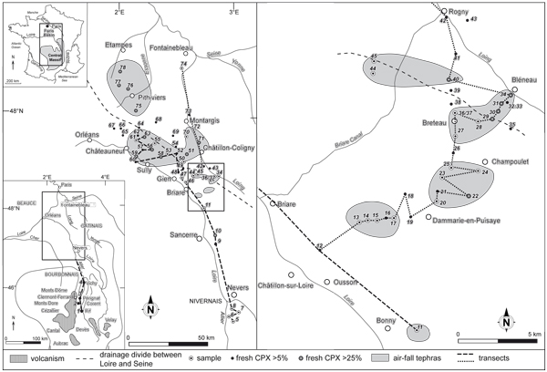
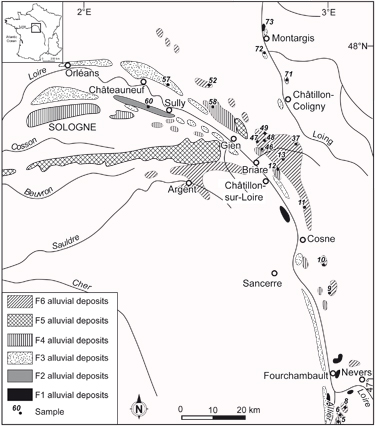
From a source at an altitude of 1406 m in the Southern Central Massif, the Loire River follows a northwards course up to the Sologne Basin where it turns before joining the Atlantic Ocean. The general geological setting is shown in Figs. 1 ![]() , 2
, 2 ![]() and 3
and 3 ![]() . The Massif Central includes a basement of crystalline and metamorphic rocks, and several Tertiary basins followed by the Loire and its main affluent, the Allier, and volcanic massifs (Velay, Devès, Aubrac, Cantal, Mont Dore and Monts Dôme). In the Paris basin, the Loire crosses Mesozoic sediments before entering the Cenozoic Sologne Basin. There, the Upper Pliocene Bourbonnais sands cover the Miocene Sologne sands and are locally overlain by Lower Pleistocene deposits containing
many augite-bearing (F6) alluvial deposits (Fig. 3
. The Massif Central includes a basement of crystalline and metamorphic rocks, and several Tertiary basins followed by the Loire and its main affluent, the Allier, and volcanic massifs (Velay, Devès, Aubrac, Cantal, Mont Dore and Monts Dôme). In the Paris basin, the Loire crosses Mesozoic sediments before entering the Cenozoic Sologne Basin. There, the Upper Pliocene Bourbonnais sands cover the Miocene Sologne sands and are locally overlain by Lower Pleistocene deposits containing
many augite-bearing (F6) alluvial deposits (Fig. 3 ![]() ). These
beds cap hills located in the Orléans forest on the drainage divide between the Loire and Seine basins. Where the Briare canal was constructed, the interfluve between the Loire and Loing basins is less than 50 m above the two rivers, and glacis shaping has eroded and reworked the deposits on the drainage divide.
). These
beds cap hills located in the Orléans forest on the drainage divide between the Loire and Seine basins. Where the Briare canal was constructed, the interfluve between the Loire and Loing basins is less than 50 m above the two rivers, and glacis shaping has eroded and reworked the deposits on the drainage divide.
In the Southern Paris basin, the terrace system of the Loire river changes downstream ( & ,
2001). In the Nivernais and Sologne districts, six main depositional terraces can be identified, whereas between these two sectors, there are only three (Fig. 3 ![]() ). The notations F6 to F0 chosen to identify the alluvial deposits are different from those shown on the geological maps. Downstream from Briare, the Tertiary and Quaternary formations spread out like a fan, allowing the preserving of inset stepped terraces. The alluvial deposits that accumulated during periglacial periods are generally composed of several truncated braided-channel fills with inclined beds of sands cut by beds of pebbles.
After the deposition of the F6 alluvial deposits, all subsequent alluvial deposits contain volcanic minerals (,
2003; , 1987,
2005).
). The notations F6 to F0 chosen to identify the alluvial deposits are different from those shown on the geological maps. Downstream from Briare, the Tertiary and Quaternary formations spread out like a fan, allowing the preserving of inset stepped terraces. The alluvial deposits that accumulated during periglacial periods are generally composed of several truncated braided-channel fills with inclined beds of sands cut by beds of pebbles.
After the deposition of the F6 alluvial deposits, all subsequent alluvial deposits contain volcanic minerals (,
2003; , 1987,
2005).
The samples shown on Figure 1 and Table 1 were taken at a depth of about 2 m in the terraces sands of the Allier, Loire and Loing, and at a depth of 40-60 cm under the cultivated soils in the other surficial formations. Heavy minerals in the 40-315 µm fraction were isolated by sieving and density separation in bromoform, according to the methods of et alii (1970) and & (1991), then the CPX were examined by petrographic microscope. More than 2100 CPX grains were studied and their form and etching phenomena noted. CPX are moderately susceptible to weathering ( et alii, 1980; & , 1982; et alii, 1999; , 2000; , 2007), its effects shown by changes in color and in the degree of etching. As CPX corrode gradually, they can survive long enough for the stage of corrosion to provide useful formation on relative age and weathering environment (, 1987).
| sample | location |
altitude (m) |
altitude above present river |
notation BRGM |
notation in this paper | CPX grains counted |
% CPX |
mean grain-size (µm) | % fresh CPX | % brown | % green |
% green- brown |
% ILC |
| 1 | Rif du Creux | 460 | 90 | P | P | 38 | 32 | 310 | 0 | 60 | 25 | 8 | 7 |
| 2 | Corent | 590 | 260 | P | P | 36 | 54 | 500 | 72 | 68 | 16 | 4 | 12 |
| 3 | Pérignat | 335 | 10 | Fy | F1 | 36 | 25 | 380 | 77 | 66 | 3 | 18 | 13 |
| 4 | Vichy | 251 | 1 | Fz | F0 | 36 | 51 | 380 | 66 | 51 | 21 | 10 | 18 |
| 5 | Gigny | 193 | 21 | Fv | F4 | 35 | 65 | 300 | 46 | 48 | 24 | 11 | 17 |
| 6 | Saincaize | 215 | 43 | Fv | F5 | 35 | 57 | 360 | 40 | 66 | 16 | 9 | 9 |
| 7 | Theuran | 220 | 47 | P | P | 40 | 44 | 320 | 15 | 47 | 14 | 16 | 23 |
| 8 | Gimouille | 225 | 55 | Ft | F6 | 36 | 45 | 320 | 36 | 66 | 15 | 7 | 12 |
| 9 | Pouilly | 174 | 20 | p2 | F6 | 36 | 39.5 | 300 | 0 | 52 | 16 | 16 | 16 |
| 10 | Moussard | 205 | 58 | Ft | F6 | 35 | 40.2 | 150 | 25 | 50 | 11 | 13 | 26 |
| 11 | Vaupy | 170 | 30 | Ft | F6 | 35 | 49 | 320 | 19 | 51 | 14 | 17 | 18 |
| 12 | NE Châtillon | 147 | 20 | Fv | F4 | 35 | 54.7 | 270 | 3 | 38 | 25 | 16 | 21 |
| 13 | Beau Désert | 178 | 48 | eK | F6 | 36 | 35 | 300 | 7 | 35 | 17 | 17 | 31 |
| 14 | cote 183 | 183 | 53 | eK | G | 40 | 41.9 | 320 | 17 | 34 | 24 | 32 | 10 |
| 15 | Pignon blanc | 182 | 55 | e-g | G | 36 | 31.9 | 280 | 21 | 34 | 20 | 20 | 26 |
| 16 | W Dammarie | 189 | 59 | e-g | G | 36 | 42.8 | 300 | 2 | 48 | 19 | 17 | 16 |
| 17 | W Dammarie | 182 | 52 | e-g | G | 36 | 27.7 | 300 | 6 | 36 | 19 | 25 | 20 |
| 18 | NW Dammarie | 187 | 57 | e-g | G | 36 | 19 | 290 | 0 | 51 | 13 | 30 | 6 |
| 19 | Les Maillards | 175 | 31 | e-Gc | G | 36 | 38.7 | 240 | 1 | 45 | 15 | 21 | 19 |
| 20 | NNE Dammarie | 175 | 31 | LPs | G | 36 | 24.3 | 240 | 10 | 33 | 17 | 32 | 18 |
| 21 | Petite Métairie | 180 | 36 | LPs | G | 32 | 15.8 | 250 | 3 | 61 | 10 | 19 | 10 |
| 22 | Bois du Château | 185 | 27 | e-g | G | 36 | 37.1 | 240 | 30 | 27 | 17 | 23 | 33 |
| 23 | La Foucherie | 185 | 41 | LPs | G | 36 | 42.4 | 250 | 11 | 49 | 18 | 12 | 21 |
| 24 | Les Claies | 185 | 27 | LPs | G | 30 | 30 | 240 | 10 | 48 | 15 | 20 | 17 |
| 25 | La Foucherie | 182 | 38 | e | G | 32 | 18.9 | 240 | 7 | 34 | 6 | 42 | 18 |
| 26 | Les Plaindresses | 182 | 38 | e | G | 30 | 15.4 | 230 | 3 | 14 | 23 | 45 | 18 |
| 27 | Le Vieux Muguet | 182 | 38 | LPs | G | 32 | 18.2 | 240 | 6 | 37 | 8 | 16 | 39 |
| 28 | L'Huilerie | 185 | 27 | LPs | G | 24 | 14.8 | 230 | 21 | 34 | 22 | 12 | 32 |
| 29 | Le Rosier | 185 | 27 | LPs | G | 26 | 13 | 240 | 46 | 34 | 22 | 12 | 32 |
| 30 | SW Bléneau | 183 | 25 | LPs | G | 13 | 13 | 38 | 30 | 30 | 7 | 33 | |
| 31 | Les Garniers | 180 | 22 | LPs | G | 11 | 13 | 38 | 27 | 18 | 9 | 46 | |
| 32 | Bléneau | 180 | 22 | LPs | G | 5 | 3.4 | 0 | |||||
| 33 | Bléneau | 179 | 21 | e-g | e-g | 0 | 0 | 0 | |||||
| 34 | Bléneau | 158 | 0 | Fz | F0 | 43 | 10 | 56 | 48 | 25 | 16 | 11 | |
| 35 | cote 191 | 191 | 33 | LPs | G | 5 | 5.1 | 0 | |||||
| 36 | Breteau | 180 | 36 | e-g | G | 35 | 2.4 | 340 | 6 | 25 | 25 | 25 | 25 |
| 37 | Breteau | 179 | 35 | e-g | F6 | 35 | 7 | 330 | 0 | 35 | 25 | 20 | 20 |
| 38 | La Margaudière | 180 | 36 | e-g | G | 2 | 1.4 | 260 | 0 | ||||
| 39 | Les Grands | 180 | 36 | RIII-H | G | 13 | 9.9 | 250 | 0 | 45 | 10 | 20 | 25 |
| 40 | Les Loges | 180 | 36 | RIII-H | G | 21 | 11.2 | 250 | 33 | 40 | 18 | 27 | 15 |
| 41 | SSE Rogny | 170 | 24 | RIII-H | G | 28 | 11 | 260 | 0 | 40 | 18 | 27 | 15 |
| 42 | Rogny | 142 | 0 | Fz | F0 | 12 | 4.5 | 280 | 20 | 52 | 22 | 15 | 11 |
| 43 | SE Rogny | 173 | 31 | P | P | 0 | 5.1 | 0 | |||||
| 44 | NW Escrigneules | 175 | 35 | m1b | G | 31 | 9.8 | 250 | 14 | 24 | 32 | 24 | 20 |
| 45 | NE Escrigneules | 170 | 30 | e-gm | G | 28 | 11.5 | 300 | 12 | 32 | 12 | 16 | 40 |
| 46 | N La Forêt | 180 | 52 | Ft | F6 | 40 | 51 | 300 | 22 | 57 | 10 | 16 | 17 |
| 47 | Bois des Sables | 185 | 60 | N | F6 | 36 | 54 | 320 | 6 | 47 | 17 | 28 | 8 |
| 48 | E La Neslerie | 185 | 65 | m1b | F6 | 36 | 23 | 320 | 0 | 31 | 29 | 11 | 29 |
| 49 | S Le Temple | 180 | 60 | m1b | F6 | 37 | 27.6 | 270 | 3 | 33 | 22 | 18 | 27 |
| 50 | S La Bussière | 169 | 39 | m1b | G | 23 | 5.2 | 290 | 6 | 27 | 18 | 27 | 28 |
| 51 | Les Bézards | 139 | 14 | e-g | G | 39 | 19.7 | 260 | 25 | 50 | 17 | 17 | 16 |
| 52 | NE carrefour d'Orléans | 174 | 61 | m2 | F6 | 36 | 12.3 | 270 | 0 | 29 | 16 | 16 | 39 |
| 53 | N Les Choux | 150 | 30 | m1b | G | 29 | 13.3 | 290 | 9 | 57 | 17 | 14 | 12 |
| 54 | Varennes-Changy | 143 | 27 | m1b | G | 2 | 1 | ||||||
| 55 | S Chatenoy | 133 | 27 | m1b5 | G | 20 | 1.6 | 330 | 5 | 20 | 26 | 14 | 40 |
| 56 | La Belle Ecuellée | 135 | 27 | m1 | G | 33 | 13.6 | 260 | 27 | 43 | 20 | 13 | 24 |
| 57 | E St-Aignan | 127 | 21 | Fw | F3 | 30 | 4.8 | 280 | 3 | 30 | 14 | 6 | 50 |
| 58 | Le Ravoir | 140 | 20 | Fv | F4 | 16 | 3.3 | 280 | 37 | 44 | 20 | 5 | 31 |
| 59 | St-Benoît-sur-Loire | 107 | 1 | Fz | F0 | 38 | 49 | 290 | 58 | 57 | 11 | 17 | 15 |
| 60 | Quaiboeuf | 117 | 14 | Fx | F2 | 36 | 12.7 | 280 | 0 | 65 | 10 | 5 | 20 |
| 61 | S Vitry-aux-Loges | 128 | 22 | m1bS | G | 36 | 24.4 | 300 | 11 | 46 | 17 | 20 | 17 |
| 63 | N Seichebrières | 134 | 24 | m1b | G | 26 | 15.7 | 280 | 60 | 59 | 7 | 13 | 21 |
| 64 | carrefour des 9 routes | 134 | 28 | m1bS | M | 4 | 1 | ||||||
| 66 | N Fay-aux Loges | 127 | 24 | m1b | G | 5 | 1.7 | 260 | 0 | 30 | 20 | 20 | 30 |
| 67 | Cléchy | 126 | 24 | m1b | M | 0 | 0 | ||||||
| 68 | S Bellegarde | 110 | 15 | m1b | G | 22 | 3.4 | 310 | 2 | 35 | 8 | 20 | 37 |
| 69 | SE Thimory | 106 | 6 | g3a | G | 30 | 12.8 | 320 | 0 | 35 | 15 | 27 | 23 |
| 70 | Solterre | 109 | 10 | g3a | G | 36 | 5 | 260 | 7 | 46 | 8 | 12 | 34 |
| 71 | Montbouy | 128 | 28 | e-gm | F2 | 37 | 7 | 250 | 26 | 42 | 14 | 9 | 35 |
| 72 | Amilly | 100 | 10 | Fx | F2 | 22 | 4.7 | 250 | 10 | 40 | 30 | 12 | 18 |
| 73 | S Cépoy | 90 | 10 | Fy | F1 | 26 | 5.5 | 270 | 0 | 33 | 35 | 15 | 17 |
| 74 | Gretz-sur-Loing | 56 | 0 | Fz | F0 | 37 | 16 | 300 | 18 | 44 | 17 | 20 | 19 |
| 75 | N Verrines | 114 | 132 | LP | LP | 26 | 12 | 260 | 25 | 47 | 28 | 13 | 12 |
| 76 | Charmont-en-Beauce | 123 | 135 | LP | LP | 25 | 15 | 260 | 52 | 47 | 28 | 13 | 12 |
| 77 | Allainville | 132 | 135 | LP | LP | 22 | 15 | 250 | 52 | 47 | 28 | 13 | 12 |
| 78 | SE Méréville | 134 | 134 | LP | LP | 18 | 12 | 260 | 25 | 47 | 28 | 13 | 12 |
Table 1
Tableau 1
Based on crystal form and the extent of etching, a morphological grid (Fig. 4 ![]() ) was established. As an example, sample 29 (Le Rosier) shows the position in the grid of the 26 observed grains: 46% are unaltered or
slightly altered (rows A and B), 30% have rounded terminations due to fluvial transport (row C), and 24% are highly weathered (rows D-F). The losses of CPX
volume can be estimated but not precisely measured, because the exact form of the original minerals is unknown. Therefore only two grain-type assemblages have been distinguished, each including several types of crystal form and extents of etching (Fig. 5
) was established. As an example, sample 29 (Le Rosier) shows the position in the grid of the 26 observed grains: 46% are unaltered or
slightly altered (rows A and B), 30% have rounded terminations due to fluvial transport (row C), and 24% are highly weathered (rows D-F). The losses of CPX
volume can be estimated but not precisely measured, because the exact form of the original minerals is unknown. Therefore only two grain-type assemblages have been distinguished, each including several types of crystal form and extents of etching (Fig. 5 ![]() ).
).
The first assemblage includes the fresh minerals with little or no alteration, which consist of:
On the grid, this first assemblage corresponds to the two upper rows A and B.
The second assemblage contains moderately and strongly weathered CPX, including:
On the grid, the second assemblage is represented in rows C, D, E and F.
Four types of CPX can be distinguished by color: 1) green CPX; 2) brown CPX; 3) CPX with intermediate or light color (ILC); 4) green-brown CPX. The last type includes the grains which have stepped surfaces, the upper surface green and the lower brown. This differential weathering is probably controlled by cleavage.
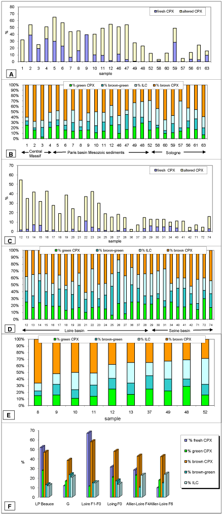
Table 1 and graph A (Fig. 6 ![]() ) show the percentages of all the CPX types including fresh CPX in the alluvial deposits of the Allier and middle Loire, from the center of the Massif Central to Orléans. As far as Briare, all the terraces have a relatively constant CPX percentage (50% on average), whereas downstream from Briare, a noticeable decrease of total CPX is recorded, except in current alluvial deposits. For example, in the present-day alluvium of the Loire, at Saint-Benoît-sur-Loire, CPX still forms 49% of the total heavy minerals.
) show the percentages of all the CPX types including fresh CPX in the alluvial deposits of the Allier and middle Loire, from the center of the Massif Central to Orléans. As far as Briare, all the terraces have a relatively constant CPX percentage (50% on average), whereas downstream from Briare, a noticeable decrease of total CPX is recorded, except in current alluvial deposits. For example, in the present-day alluvium of the Loire, at Saint-Benoît-sur-Loire, CPX still forms 49% of the total heavy minerals.
The stability of the CPX percentage upstream of Briare be explained by inputs of volcanic ash and/or breakdown of basaltic pebbles delivering CPX grains to the alluvium. On the other hand, downstream ftom Briare, the noticeable decrease could result from the incorporation there of Sologne sands which are very poor in volcanic minerals.
The CPX percentage varies with the age of the terraces. For example, in the Sologne, the CPX percentage is high in the present-day alluvium (F0) (49%) and in the F6 terrace (30%) and decreases with the increasing age of the intermediate terraces (12.7% in F2, 4.8% in F3 and 3.3% in F4).
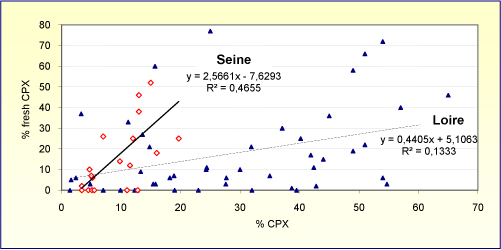
Variation in the content of fresh CPX is less consistent: there is a rapid decrease near the margins of the Sologne, then a strong increase downstream from Gien and in the Orléans forest, where the presence of non-rounded CPX splinters suggests important inputs of ash. The western boundary of the ash falls is located close to Châteauneuf-sur-Loire, east of Orléans. The high terraces of the Allier and the Loire show stronger downstream decreases of fresh CPX than do the middle and low terraces; for example, the F6 alluvial deposits contain 36 % of fresh CPX in the Nivernais region and 0 % in the Orléans forest. The fresh CPX percentage generally decreases with increasing age from F0 to F6, but exceptions occur in the Sologne where the intermediate F2 and F3 terraces are very poor in fresh CPX. No relationships exist between the percentages of total CPX and of fresh non-weathered CPX in any of the samples (Fig. 7 ![]() ). On the other hand, the correlation is better (r² = 0.56) for the Seine basin samples than for the Loire basin (r² = 0.13).
). On the other hand, the correlation is better (r² = 0.56) for the Seine basin samples than for the Loire basin (r² = 0.13).
Between the Loire and the Loing, the transect (Fig. 6 ![]() , graph C) crosses glacis on the valley slopes derived from very high terraces of the Loire. The noticeable decrease in the amount of total CPX in the direction of the Loing valley is explained by the restricted stock of volcanic minerals in the higher alluvial deposits of the Loire, especially of the F6. However, locally spectacular increases of fresh CPX occur near the Loing valley and also within that valley, as at Bléneau. Among these CPX can be found splinters and prisms with denticular ends, very similar to those of the Rif du Creux, east of Mont Dore. It is obvious that these minerals are not derived directly from a paleo-Loire because the Loire deposits close to the hypothetical Loire-Seine gap do not contain fresh CPX, and the CPX located to the northwest, near the drainage divide between the Loire, the Loing and the Essonne, are all strongly weathered, except for those in the loess of the Beauce region. These supplies of fresh CPX explain the stronger correlation between percentages of total CPX and non weathered CPX in the Seine basin.
, graph C) crosses glacis on the valley slopes derived from very high terraces of the Loire. The noticeable decrease in the amount of total CPX in the direction of the Loing valley is explained by the restricted stock of volcanic minerals in the higher alluvial deposits of the Loire, especially of the F6. However, locally spectacular increases of fresh CPX occur near the Loing valley and also within that valley, as at Bléneau. Among these CPX can be found splinters and prisms with denticular ends, very similar to those of the Rif du Creux, east of Mont Dore. It is obvious that these minerals are not derived directly from a paleo-Loire because the Loire deposits close to the hypothetical Loire-Seine gap do not contain fresh CPX, and the CPX located to the northwest, near the drainage divide between the Loire, the Loing and the Essonne, are all strongly weathered, except for those in the loess of the Beauce region. These supplies of fresh CPX explain the stronger correlation between percentages of total CPX and non weathered CPX in the Seine basin.
The graphs B, D, E and F (Fig. 6 ![]() ) show the geographical distribution of color variation of CPX. In the Loire valley, all the terraces show a decrease in brown CPX downstream whereas the green, green-brown and ILC (intermediate-light-colored) CPX generally increase. The F6 terrace shows the most pronounced downstream changes (graph E). Many of the CPX in the F6 terrace CPX show rounded terminations due to fluvial transport. Between the Loire and the Loing, green CPX increases slightly from 17 to 20% whereas brown CPX decreases from 40 to 37% and the ILC remain stable at 43%; but locally there are strong increases in either brown and green CPX. Green-brown CPX, which does not exceed 10% of the total CPX in the Allier valley, reaches 40% near the Loire-Seine drainage divide.
) show the geographical distribution of color variation of CPX. In the Loire valley, all the terraces show a decrease in brown CPX downstream whereas the green, green-brown and ILC (intermediate-light-colored) CPX generally increase. The F6 terrace shows the most pronounced downstream changes (graph E). Many of the CPX in the F6 terrace CPX show rounded terminations due to fluvial transport. Between the Loire and the Loing, green CPX increases slightly from 17 to 20% whereas brown CPX decreases from 40 to 37% and the ILC remain stable at 43%; but locally there are strong increases in either brown and green CPX. Green-brown CPX, which does not exceed 10% of the total CPX in the Allier valley, reaches 40% near the Loire-Seine drainage divide.
Graph F (Fig. 6 ![]() ) shows the mean fresh CPX percentage and the color characteristics of the main regional units. Fresh CPX abounds in the F0 and F1 Loire alluvial deposits and in the Beauce loams, but it is scarce in the F6 Loire terrace and glacis deposits. In the Orléans forest and in the Beauce region, the fresh CPX, often splinted, are as common among the green minerals as among the brown. The Beauce loams are characterized by the highest percentage of green CPX and the lowest percentages of green-brown and ILC. In the glacis deposits, brown and green CPX coexist in equal amounts with green-brown and ILC, suggesting two discrete supplies. The F0 alluvial deposits are richer in fresh CPX and brown CPX in the Loire valley than in the course of the Loing. ILC abounds in the high Loire terraces and in the glacis deposits, suggesting that the glacis deposits are derived from the Loire terraces.
) shows the mean fresh CPX percentage and the color characteristics of the main regional units. Fresh CPX abounds in the F0 and F1 Loire alluvial deposits and in the Beauce loams, but it is scarce in the F6 Loire terrace and glacis deposits. In the Orléans forest and in the Beauce region, the fresh CPX, often splinted, are as common among the green minerals as among the brown. The Beauce loams are characterized by the highest percentage of green CPX and the lowest percentages of green-brown and ILC. In the glacis deposits, brown and green CPX coexist in equal amounts with green-brown and ILC, suggesting two discrete supplies. The F0 alluvial deposits are richer in fresh CPX and brown CPX in the Loire valley than in the course of the Loing. ILC abounds in the high Loire terraces and in the glacis deposits, suggesting that the glacis deposits are derived from the Loire terraces.
The brown CPX come mainly from erosion of the Velay and Cézallier basaltic lava flows whereas the green CPX are mainly from the Mont-Dore ash fall (, 1987; and , 2001), but the recent eruptions on the Central Massif and the Eifel have supplied either green or brown CPX (, 1987; , 1991; et alii, 1996). Volcanism in western Europe was episodic and correlates with the warming phases at the onset of interglacials ( et alii, 2006). The Mont Dore eruptions occurred mainly between 2.6 Ma and 1.5 Ma, then between 0.8 Ma and 0.25 Ma (, 1987; & , 2001), that is to say at the end of deposition of the F6, F4 and F3 terraces. The Chaîne des Puys and Eifel main eruptions are concentrated between 17 ka and 5 ka. The main tephras were produced at 12 ka by the Puy de la Nugère (Chaîne des Puys), at 11 ka by the Laacher See (Eifel), and at 9.21 ka by the Vasset and Chopine (Chaîne des Puys) ( & , 2000; et alii, 2000; et alii, 2004; et alii, 2004; et alii, 2006; et alii, 2006). They occurred at the end of the accumulation of the Weichselian deposits. In the whole Loire basin, brown CPX exceeds green CPX, and the Devès basaltic lavas could have supplied about 10% of the original brown-green CPX (, 2005).
The recent eruptions (17-5 ka) explain the strong increase of fresh green and brown CPX in the surficial formations (soils and glacis deposits) of the Sologne, the Gâtinais and the Beauce. The mineral composition of these air-fall tephras is characteristic of trachytic eruptions, and the absence of olivine could exclude a Chaîne des Puys and also a Loire alluvial plain origin as (1984) assumed because olivine is very abundant in the recent Loire deposits (, 2003).
The fresh minerals of the first assemblage (rows A and B of Fig. 4 ![]() ) have been shaped more by mechanical processes during their eruption or by fluvial transportation than by chemical weathering. According to
(2005) "the tephra minerals can be well crystallized or very splinted". In the alluvial plain deposits, fluvial processes do not greatly reduce the amount of fresh grains downstream (66% at Vichy, 58% at Saint-Benoît-sur-Loire) because attrition of the basaltic pebbles in the sediment load contributes new grains (,
1995). Explosive volcanism could have projected fresh minerals to the Beauce, the Gâtinais and the Orléans forest ( & ,
1996; , 1991). Although
(1991) put the western boundary of the ash falls of the Laacher See upper tephra as west of Orléans, the fresh minerals found at the sampling sites do not extend west of Châteauneuf-sur-Loire. These ash supplies are mainly later than the Loing low terrace as shown by the occurrence of fresh CPX in the soil and their absence in the coarse terrace deposits.
) have been shaped more by mechanical processes during their eruption or by fluvial transportation than by chemical weathering. According to
(2005) "the tephra minerals can be well crystallized or very splinted". In the alluvial plain deposits, fluvial processes do not greatly reduce the amount of fresh grains downstream (66% at Vichy, 58% at Saint-Benoît-sur-Loire) because attrition of the basaltic pebbles in the sediment load contributes new grains (,
1995). Explosive volcanism could have projected fresh minerals to the Beauce, the Gâtinais and the Orléans forest ( & ,
1996; , 1991). Although
(1991) put the western boundary of the ash falls of the Laacher See upper tephra as west of Orléans, the fresh minerals found at the sampling sites do not extend west of Châteauneuf-sur-Loire. These ash supplies are mainly later than the Loing low terrace as shown by the occurrence of fresh CPX in the soil and their absence in the coarse terrace deposits.
Weathering is responsible for the second CPX assemblage (Fig. 4 ![]() , rows C, D, E and F). Etched grain surfaces are commonly attributed to intrastratal solution (,
1985; & ,
2007), but they also may occur "as the result of comagmatic and/or late-magmatic processes" ( & ,
1993). Here, CPX weathering is favored by groundwater fluctuations during the accumulation of alluvia (,
1995), as well as by subsequent pedogenic processes under acidic conditions. Thus, the degree of weathering increases with the age of the terrace and the duration of soil formation, except where non-acidic
conditions occur. F6 alluvial deposits:may still include
CaCO3 where they overlie limestone outcrops as is the case between Nevers and Gien where the CPX are well preserved, but in the Sologne district the fresh CPX disappear progressively because of acidic conditions. On the Loire-Loing interfluve, the CPX in colluvial and glacis deposits are strongly weathered because of very acidic conditions. Similar effects on other heavy minerals have been described by
(1973), (1987,
1989) and (2000).
, rows C, D, E and F). Etched grain surfaces are commonly attributed to intrastratal solution (,
1985; & ,
2007), but they also may occur "as the result of comagmatic and/or late-magmatic processes" ( & ,
1993). Here, CPX weathering is favored by groundwater fluctuations during the accumulation of alluvia (,
1995), as well as by subsequent pedogenic processes under acidic conditions. Thus, the degree of weathering increases with the age of the terrace and the duration of soil formation, except where non-acidic
conditions occur. F6 alluvial deposits:may still include
CaCO3 where they overlie limestone outcrops as is the case between Nevers and Gien where the CPX are well preserved, but in the Sologne district the fresh CPX disappear progressively because of acidic conditions. On the Loire-Loing interfluve, the CPX in colluvial and glacis deposits are strongly weathered because of very acidic conditions. Similar effects on other heavy minerals have been described by
(1973), (1987,
1989) and (2000).
In the Loire valley, the decrease in brown CPX is due to weathering which has produced minerals with intermediate or light colours (ILC), between green and brown, even colorless or two-colored grains. About 10% of the two-colored CPX are zoned grains supplied by the Devès lavas, but 90 % are due to weathering. This previously unrecorded weathering phenomenon affects only the brown CPX which, because of their high content of alkalis, are less stable than the green CPX (, 1979). According to (1987, 2005), the brown CPX are more alkali-rich and contain a higher Al2O3 and TiO2 content than the green CPX. This is indicative of alkali basalts ( et alii, 1982). The heart of the two-colored grains is always brown and fresh whereas the weathered margins are green and porous; the reverse has never been observed. The outer green layer results from loss of Mg and Ca by leaching ( et alii, 1981; & , 1985) and once formed, the thickness of the leached layer remains constant over time, as et alii (2008) have shown. Therefore, in the studied area, the green CPX have three origins:
This research has shown a strong dissemination of CPX over the Loire-Seine interfluve, but the CPX evidence does not prove Loire-Seine connection because no alluvial fresh CPX have been found. CPX morphology and color indicate that most CPX grains, strongly weathered and colorless, come from material derived from the area of Loire sedimentation, but were not deposited by direct fluvial transport by the Loire. The fresh strongly-colored CPX, which are locally the second-most common type originated in ash falls (explosive eruptions of the Eifel and Chaîne des Puys between 17 and 5 ka). These findings support the hypothesis that no Loire-Seine connection occurred after the accumulation of the Burdigalian Sologne sands ( & , 2002).
The morphology and color of the CPX grains also indicate that brown CPX tend to become green when weathered under acidic conditions. This phenomenon explains the large amounts of green CPX in the middle Loire even though brown CPX generally predominates in the Massif Central. Scanning electron microscopy (SEM) would increase our knowledge of the alteration processes of CPX.
We are grateful to M. , S. and M. , three cartographers of Paris-Val de Marne University, for drawing the figures. We also thank J. for reviewing the English text, and D. for very helpful comments that improved the manuscript.
P., J.P. & M. (2000).- Long-term fluvial archives in NW France: response of the Seine and Somme rivers to tectonic movements, climatic variations and sea-level changes.- Geomorphology, Amsterdam, vol. 33, n° 3-4, p. 183-207.
R.A. & J. (1982).- Mechanism of pyroxene and amphibole weathering: II. Observations of soil grains.- American Journal of Science, New Haven, vol. 282, p. 1214-1231.
R.A., E.L., M.A. & M.D. (1980).- Dissolution of pyroxenes and amphiboles during weathering.- Science, Washington, vol. 207, n° 4436, p. 1205-1206.
P. (1967).- Problèmes du volcanisme II : VI Augites en dents de scie.- Revue d'Auvergne, Clermont-Ferrand, t. 81, p. 69.
C., L., S., C. & J. (1993).- Les écoulements fluviatiles successifs issus du Massif central dans le Bassin parisien, tributaires de l'Atlantique ou de la Manche au Néogène-Pléistocène : relations avec la tectonique.- Colloque "Géologie de la France" (14-15 décembre 1993), Paris, 2 p. (résumé).
R. & J.P.(1996).- Mise en évidence d'une troisième source de clinopyroxènes dans les alluvions de la Seine et de ses affluents méridionaux.- Comptes Rendus de l'Académie des Sciences, Paris, (série II a), vol. 323, n° 10, p. 849-854.
A., J.J., J.B., J., B. & G. (2006).- Tephras in lacustrine sediments of the Sarliève marsh (French Massif Central): age and preservation.- Comptes Rendus Geoscience, Paris, vol. 338, n° 16, p. 1141-1149.
J.P., P. & H. (1972).- Les apports volcaniques en Seine et Manche Centrale.- Mémoires du Bureau de Recherches Géologiques et Minières, Orléans, n° 79, p. 257-262.
E. (1976).- Contribution à la connaissance de la stratigraphie du Quaternaire par l'étude des minéraux denses transparents de l'Eifel au Massif Central français, et plus particulièrement en Belgique.- Thèse, Université de Liège, 236 p.
E. (1977).- La zone de dispersion des poussières émises par une des dernières éruptions du volcan Laachersee (Eifel).- Zeitschrift fur Geomorphologie, Stuttgart, vol. 21, n° 3, p. 323-342.
E. (1991).- Distribution de vastes retombées volcaniques originaires de l'Eifel et du Massif Central aux temps post-glaciaires dans le NE de la France et les régions voisines.- Comptes Rendus de l'Académie des Sciences, Paris, (série II), vol. 312, n° 4, p. 415-420.
E. (1992).- Téphrostratigraphie et géomorphologie en Belgique. In : Rythmes morphogéniques en domaine volcanisé.- Actes du Colloque AGF de Clermont-Ferrand (5 décembre 1992), Centre d'études et de recherches appliquées au Massif Central, à la moyenne montagne et aux espaces fragiles (CERAMAC), Clermont-Ferrand, p. 151-162.
E. (1993).- Contribution à la téphrostratigraphie du Quaternaire et son application à la géomorphologie.- Mémoire pour l'Explication des Cartes géologiques et minières de la Belgique, Bruxelles, vol. 36, 66 p.
E., B., G., J., M., E. & M. (1996).- A comprehensive pollen- and tephra-based chronostratigraphic model for the late glacial and holocene period in the French Massif Central.- Quaternary International, Washington, vol. 34-36, p. 113-120.
H., S., J. & W. (1999).- Heavy mineral analysis and clinopyroxene geochemistry applied to provenance analysis of lithic sandstones from the Azuro-Soná Complex (NW Panama).- Sedimentary Geology, Amsterdam, vol. 124, n° 1-4, p. 149-168.
L.O. (2000).- Heavy mineral weathering under acidic soil conditions.- Applied Geochemistry, Amsterdam, vol. 15, n° 4, p. 415-423.
J.P. (1979).- Les nappes alluviales de la Loire et de ses affluents dans le Massif Central et dans le sud du Bassin Parisien : étude géomorphologique.- Thèse d'État Géographie, Clermont II, multigraphiée, 543 p.
J.P. (1999).- Le fleuve à augite dans le Bassin parisien : nouveaux éléments d'interprétation.- Géologie de la France, Orléans, vol. 3, p. 11-16.
J.P. (2003).- L'encaissement inégal de la Seine et la Loire dans le Bassin parisien (France).- Géographie physique et Quaternaire, Montréal, vol. 57, n° 1, p. 21-36.
J.P. & R. (2001).- Morphodynamique fluviale et tectonique : l'exemple de la vallée de la Loire dans le sud du Bassin parisien (France).- Géomorphologie, Créteil, vol. 7, n° 4, p. 281-294.
J.P. & R. (2002).- Les Sables de Lozère et les Sables de Sologne : nouvelles interprétations de deux décharges détritiques du Miocène inférieur, issues de la paléo-Loire (Bassin parisien, France).- Bulletin de la Société géologique de France, Paris, vol. 173, n° 2, p. 185-192.
J., R.C., P., D. & M. (1982).- Clinopyroxene composition as a method of identification of the magmatic affinities of paleo-volcanic series.- Earth Planetary Science Letters, Amsterdam, vol. 59, n° 1, p. 139-154.
T., H.U. & B. (2003).- Environmental response to climatic and volcanic events in central Europe during the Weichselian Lateglacial.- Quaternary Science Reviews, Amsterdam, vol. 22, n° 1, p. 7-32.
J.J. (1984).- Les vallées et formations alluviales plio-quaternaires dans le S et le SW du Bassin de Paris : genèse et signification dynamique.- Bulletin de l'Association française pour l'Étude du Quaternaire, Paris, vol. 1-2-3, p. 37-40.
M. & H. (1991).- Schwerminerale in Farbe.- Enke Verlag, Stuttgart, 148 p.
J.J. (1979).- Contribution à l'étude pétrogénétique des nappes de ponces du massif volcanique du Mont-Dore (Massif central français).- Thèse de Doctorat de 3ème cycle, Université de Paris-Sud, Orsay, 105 p.
J.P. (1972).- Le Quaternaire de la région parisienne.- Thèse de Doctorat d'État, Université Paris VI, 572 p.
A.C. (1985).- Heavy minerals in provenance studies. In: G.G. (ed.), Provenance of arenites.- D. Reidel Publishing Co., Dordrecht, p. 249-277.
A.C. & C.R. (1999).- Processes controlling the composition of heavy mineral assemblages in sandstones.- Sedimentary Geology, Amsterdam, vol. 124, n° 1-4, p. 3-29.
A.C. & C.R. (2007).- Stability of detrital heavy minerals during burial diagenesis. In: M.A. & D.T. (eds.), Heavy minerals in use.- Developments in Sedimentology, vol. 58, Elsevier, p. 215-245.
V.P. & W.C. (1993).- Heavy-mineral assemblages of continental margins as indicators of plate-tectonic environments.- Journal of Sedimentary Petrology, Tulsa, vol. 63, n° 6, p. 1110-1117.
E. (1973).- Experimental dissolution of light and heavy minerals in comparison with weathering and intrastratal solution.- Contributions to Sedimentology, Stuttgart, vol. 1, p. 1-68.
D.A.G., M.C. & D.M. (2006).- Episodic Quaternary volcanism in France and Germany.- Journal of Quaternary Science, Durham, vol. 21, n° 6, p. 645-675.
A., C. & J. (1970).- Les minéraux en grains, méthodes d'étude et détermination.- Masson, Paris, 578 p.
X. (1995).- Étude des flux détritiques sableux tertiaires et quaternaires dans la région de Gien.- Bulletin du Laboratoire Rhodanien de Géomorphologie, Lyon, vol. 33-34, p. 35-49.
J.F. (1987).- Les formations plio-quaternaires du Bassin de l'Allier et le volcanisme régional (Massif central, France).- Thèse Sciences, Paris VI, 706 p.
J.F. (2005).- Les nappes alluviales de l'Allier en Limagne (Massif central, France). Stratigraphie et corrélations avec le volcanisme.- Quaternaire, Paris, vol. 16, n° 3, p. 153-175.
J.F. & J.M. (2001).- Téphrostratigraphie du Mont-Dore (Massif central, France).- Quaternaire, Paris, vol. 12, n° 4, p. 249-267.
H. (1969).- Étude morphologique de l'augite denticulée dans les projections volcaniques du Massif du Mont Dore (Massif Central français).- Bulletin historique et scientifique de l'Auvergne, Clermont-Ferrand, n° 622, p. 182-186.
J. & R.A. (1985).- Dissolution Mechanisms of pyroxene and olivines during weathering. In: J.I. (ed.), The chemistry of weathering.- D. Reidel Publishing Co., Dordrecht, p. 35-53.
J., R.A. & E.L. (1981).- Mechanism of pyroxene and amphibole weathering. I. Experimental studies of iron-free minerals.- Geochimica et Cosmochimica Acta, Amsterdam, vol. 45, n° 11, p. 2123-2135.
J. (1972).- L'augite, indicateur stratigraphique et paléogéographique des épandages détritiques en provenance du Massif Central au Cénozoïque.- Comptes Rendus de l'Académie des Sciences, Paris, vol. 275, p. 9-12.
J., D., G. & M. (1978).- Étude des minéraux lourds des alluvions actuelles et anciennes du Loing, de l'Yonne et de la Seine en amont de Paris.- Bulletin d'Information des Géologues du Bassin de Paris, Paris, vol. 15, p. 25-33.
J. & C. (1995).- Mise en évidence, par la présence d'augite du Massif central, de l'existence d'une pré-Loire-pré-Seine coulant vers la Manche au Pléistocène.- Comptes Rendus de l'Académie des Sciences, Paris, (série II a), vol. 320, n° 12, p. 1163-1169.
C.S.M., J.J., S. M., V., D.J., S., W.Z. & B. (2004).- Tephrochronology of Last Termination Sequences in Europe: a protocol for improved analytical precision and robust correlation procedures (a joint SCOTAV-INTIMATE proposal).- Journal of Quaternary Science, Durham, vol. 19, n° 2, p. 111-120.
B., G., A.V., P., T., M. & M. (2004).- High-resolution record of environmental changes and tephrochronological markers of the Last Glacial-Holocene transition at Lake Lautrey (Jura, France).- Journal of Quaternary Science, Durham, vol. 19, n° 8, p. 797-808.
M.A. (1987).- Rate-controlling factors in the weathering of some ferromagnesian silicate minerals.- Transactions, 13th Congress of the International Society of Soil Science, Hamburg (13-20 August 1986), vol. VI, p. 1107-1118.
M.A. (1989).- Weathering of hornblende to ferruginous products by a dissolution-reprecipitation mechanism: Petrography and stoichiometry.- Clays and Clay Minerals, Chantilly, vol. 37, n° 6, p. 515-524.
M.A. (2007).- Surfaces textures and dissolution processes of heavy minerals in the sedimentary cycle: examples from pyroxenes and amphiboles. In : M.A. & D.T. (eds.), Heavy minerals in use.- Developments in Sedimentology, vol. 58, Elsevier, p. 113-150.
G. & J.P. (2000).- Un cadre téphrostratigraphique réactualisé pour la préhistoire tardiglaciaire et holocène de Limagne (Massif Central, France).- Comptes Rendus de l'Académie des Sciences, Paris, (série II), vol. 330, n° 6, p. 399-405.
V.P., H.W., G.M. & J.S. (2008).- Characterization of leached layers on olivine and pyroxenes using high-resolution XPS and density functional calculations.- Geochimica et Cosmochimica Acta, Amsterdam, vol. 72, n° 1, p. 69-86.
B., A., H., A. & J.F.W. (2000).- Annually dated late Weichselian continental palaeoclimate record from the Eifel, Germany.- Geology, Boulder, vol. 28, n° 9, p. 783-786.
Cliquer sur la miniature pour agrandir l'image.
Click on thumbnail to enlarge the image.
Figure 1: Location maps.
Figure 1 : Cartes de localisation.
Cliquer sur la miniature pour agrandir l'image.
Click on thumbnail to enlarge the image.
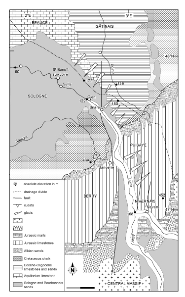
Figure 2:
Morphostructural map.
Figure 2 : Carte morphostructurale.
Cliquer sur la miniature pour agrandir l'image.
Click on thumbnail to enlarge the image.
Figure 3:
The river terraces (from , 2003).
Figure 3 : Les terrasses alluviales (d'après ,
2003).
|
|
||||||||||||||||||||||||||||||||||||||||||||||||
|
|
||||||||||||||||||||||||||||||||||||||||||||||||
Figure 4: Morphological grid for the Rosier example, sample 29.
L: CPX grain length; l: CPX grain width. For details see text.
Figure 4 : Grille d'analyse morphoscopique. Exemple du Rosier, échantillon 29.
L : CPX longueur; l : CPX largeur. Voir texte.
Cliquer sur la miniature pour agrandir l'image.
Click on thumbnail to enlarge the image.
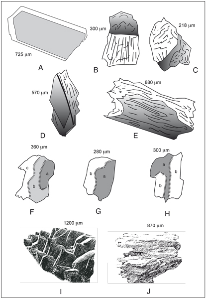
Figure 5:
Different degrees of etching in clinopyroxene grains (the highest length is marked in µm). A: prismatic green Montdorian CPX; B, C: green and brown CPX with bevelled cracks; D: green CPX with stepped cracks; E: slight peripheral weathering; F, G, H: highly weathered brown CPX with stepped surfaces and curvilinear talus; I: scaly brown CPX (SEM photograph, from ,
1987); J: very highly weathered green CPX with completely decomposed surfaces (SEM photograph, from ,
1987).
Figure 5 : Morphologie des types de clinopyroxènes rencontrés. Le chiffre en µm indique la longueur maximale des grains. A : prisme intact de clinopyroxène vert montdorien ;
B, C : cassures en biseau sur deux clinopyroxènes vert et brun ; D : CPX vert à cassures en marches d'escalier ; E : début d'altération périphérique sur un clinopyroxène vert montdorien ; F, G, H : CPX bruns à étagements et talus curvilignes
(photo MEB extraite de , 1987) ; I : CPX brun à écailles imbriquées
(photo MEB extraite de , 1987) ; J : CPX vert à surfaces entièrement détruites.
Cliquer sur la miniature pour agrandir l'image.
Click on thumbnail to enlarge the image.
Figure 6: Graphs showing the distribution of CPX in space and in time. ILC: intermediate or light coloured CPX. A and B: in the Allier and Loire valleys (based on percentages of fresh and altered CPX, the sum of the two boxes is the CPX abundance (A), based on colour (B)); C and D: between the Loire and the Loing (based on percentages of fresh and altered CPX, the sum of the two boxes is the CPX abundance (C), based on colour (D)); E: CPX colour variation for the Allier-Loire F6 terrace, upstream to downstream; F: mean characteristics of the main regional units (Beauce loam, glacis deposits, F1-F0 Allier-Loire alluvial deposits, F0 Loing, F 4 and F6 Allier-Loire alluvial deposits).
Figure 6 : Graphiques montrant l'évolution spatiale et temporelle des CPX. ILC : CPX décolorés. A et B : dans les vallées de l'Allier et de la Loire (% CPX frais et CPX altérés (A), colorimétrie (B)), C et D : entre Loire et Loing (% CPX frais et CPX altérés (C), colorimétrie (D)); E: coloration des CPX de la terrasse F6, de l'amont à l'aval; F: caractéristiques moyennes des différentes unités (loess de Beauce, dépôts de glacis, alluvions des niveaux F1-F0 Allier-Loire, F0 Loing, F 4 et F6 Allier-Loire).
Cliquer sur la miniature pour agrandir l'image.
Click on thumbnail to enlarge the image.
Figure 7: Relationships between percentages of total CPX and non weathered CPX, showing the difference between the Loire and the Seine basins.
Figure 7 : Relations entre % CPX et % CPX frais et différence entre les bassins de la Loire et de la Seine.