![]()
![]()
![]()
![]() A stratonomic and micropaleontological analysis of the Aptian marls cropping out in the La Tuilière area near Saint-Saturnin-lès-Apt (Vaucluse, SE France), enabled us to reconstitute a continuous succession almost 120 m thick, that includes the upper terms of the Lower Aptian (Bedoulian) and the lower part of the Middle Aptian (Gargasian). These levels had never before been observed with such continuity in the Gargas region, the Aptian historical stratotype.
A stratonomic and micropaleontological analysis of the Aptian marls cropping out in the La Tuilière area near Saint-Saturnin-lès-Apt (Vaucluse, SE France), enabled us to reconstitute a continuous succession almost 120 m thick, that includes the upper terms of the Lower Aptian (Bedoulian) and the lower part of the Middle Aptian (Gargasian). These levels had never before been observed with such continuity in the Gargas region, the Aptian historical stratotype.
![]() Middle Aptian; Gargasian; historical stratotype; lithology; bentonites; stratigraphy
Middle Aptian; Gargasian; historical stratotype; lithology; bentonites; stratigraphy
M., G., C. & G. (2006).- The Gargasian (Middle Aptian) of La Tuilière - St-Saturnin-lès-Apt (area of the Aptian historical stratotype, Vaucluse, SE France): geographic setting and outcrop correlation.- Carnets de Géologie / Notebooks on Geology, Brest, Letter 2006/01 (CG2006_L01)
![]() Le Gargasien (Aptien moyen) de La Tuilière St-Saturnin-lès-Apt (région du
stratotype historique de l'Aptien, Vaucluse, SE France) : localisation géographique et corrélations des affleurements.- L'analyse stratonomique et micropaléontologique des affleurements de marnes aptiennes du secteur du hameau de La Tuilière, près de Saint-Saturnin-lès-Apt (Vaucluse, SE France), nous a permis de reconstituer une série continue, épaisse de près de 120 m, comprenant les termes supérieurs de l'Aptien inférieur (Bédoulien) et la partie inférieure de l'Aptien moyen (Gargasien). Ces niveaux n'avaient jamais pu être observés avec une telle continuité dans la région de Gargas, stratotype historique de l'Aptien.
Le Gargasien (Aptien moyen) de La Tuilière St-Saturnin-lès-Apt (région du
stratotype historique de l'Aptien, Vaucluse, SE France) : localisation géographique et corrélations des affleurements.- L'analyse stratonomique et micropaléontologique des affleurements de marnes aptiennes du secteur du hameau de La Tuilière, près de Saint-Saturnin-lès-Apt (Vaucluse, SE France), nous a permis de reconstituer une série continue, épaisse de près de 120 m, comprenant les termes supérieurs de l'Aptien inférieur (Bédoulien) et la partie inférieure de l'Aptien moyen (Gargasien). Ces niveaux n'avaient jamais pu être observés avec une telle continuité dans la région de Gargas, stratotype historique de l'Aptien.
![]() Aptien moyen ; Gargasien ; stratotype historique ; lithologie ; bentonites ; stratigraphie
Aptien moyen ; Gargasien ; stratotype historique ; lithologie ; bentonites ; stratigraphie
![]() 165 years after the creation of the term
"Aptian" (d',
1840, p. 631: "on pourrait peut-être séparer entièrement cette faune et donner aux couches qui les renferment un nom spécial. Je proposerai celui d'aptiennes, les environs d'Apt en étant le siège principal") ["one might separate this fauna entirely and give the beds which contain it a special name. I shall propose 'Aptian', the surroundings of Apt being the site of its principal occurrence"], it may appear paradoxical that there is still interest in the area of the historical stratotype of this stage.
165 years after the creation of the term
"Aptian" (d',
1840, p. 631: "on pourrait peut-être séparer entièrement cette faune et donner aux couches qui les renferment un nom spécial. Je proposerai celui d'aptiennes, les environs d'Apt en étant le siège principal") ["one might separate this fauna entirely and give the beds which contain it a special name. I shall propose 'Aptian', the surroundings of Apt being the site of its principal occurrence"], it may appear paradoxical that there is still interest in the area of the historical stratotype of this stage.
![]() Indeed, with few exceptions (,
2001; et alii, 2004), the recent concerns of stratigraphers are centered on a search for type localities of stage boundaries (the majority yet to be formally defined) rather than on improving knowledge of historical stratotypes.
Indeed, with few exceptions (,
2001; et alii, 2004), the recent concerns of stratigraphers are centered on a search for type localities of stage boundaries (the majority yet to be formally defined) rather than on improving knowledge of historical stratotypes.
![]() And as regards the Aptian, the case appears to be particularly complicated, because:
And as regards the Aptian, the case appears to be particularly complicated, because:
![]() 1) by original designation its stratotype is also the type-locality of its median substage (Gargasian, from Gargas, near Apt, Vaucluse, SE France)
(Fig. 1
1) by original designation its stratotype is also the type-locality of its median substage (Gargasian, from Gargas, near Apt, Vaucluse, SE France)
(Fig. 1
![]() ),
),
![]() 2) the type-sections of the two other substages (lower = Bedoulian, and upper = Clansayesian), which were originally thought to be sparsely or poorly characterized in the Apt area, were chosen in other localities,
2) the type-sections of the two other substages (lower = Bedoulian, and upper = Clansayesian), which were originally thought to be sparsely or poorly characterized in the Apt area, were chosen in other localities,
![]() 3) the hill at Gargas, which could still be studied from a geological point of view during the last century (at least until the seventies) (,
1932, 1944; ,
1958; , 1963; ,
1965; , 1971a,
b; , 1975), is now almost entirely covered by vegetation and has been included, consequent on a rapid urbanization, in an Apt-Gargas conurbation. Outcrops there, especially the marls, have practically disappeared so observation has become difficult, even impossible, in this sector.
3) the hill at Gargas, which could still be studied from a geological point of view during the last century (at least until the seventies) (,
1932, 1944; ,
1958; , 1963; ,
1965; , 1971a,
b; , 1975), is now almost entirely covered by vegetation and has been included, consequent on a rapid urbanization, in an Apt-Gargas conurbation. Outcrops there, especially the marls, have practically disappeared so observation has become difficult, even impossible, in this sector.
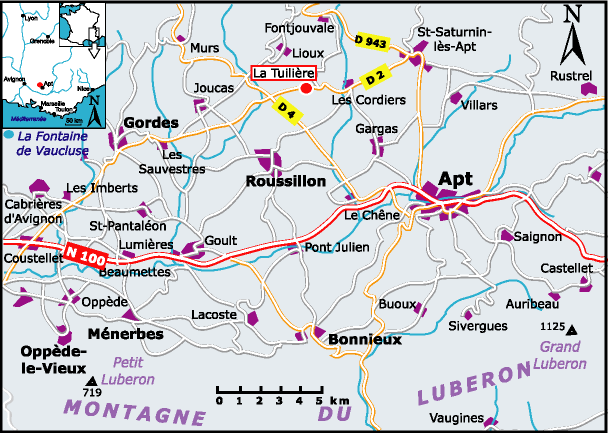
![]() Other Aptian fossiliferous localities or outcrops in the Apt region have been quoted in literature: Carniol, Saint-Saturnin d'Apt (,
1910), La Tuilière
(Figs. 1
Other Aptian fossiliferous localities or outcrops in the Apt region have been quoted in literature: Carniol, Saint-Saturnin d'Apt (,
1910), La Tuilière
(Figs. 1
![]() - 2
- 2
![]() ) (,
1865), Les Gays (, 1910; ,
1975 [under the name of "Les Barbiers"]). Thanks to L. (oral communication, 2001) who initially guided us in the field, we "rediscovered" the outcrops of Aptian marls near the hamlet of La Tuilière, located 5 km WSW of Saint-Saturnin d' Apt and 5 km NW of the hill of Gargas. We directed our new research to this sector. This research was carried out in the framework of a multidisciplinary group of stratigraphers (Gargasian Working Group). The detailed results of these studies are presented in a series of papers in this volume. At La Tuilière we have surveyed and sampled in great detail a composite section showing in continuity the upper terms of the lower Aptian (Bedoulian) and the lower terms of the middle Aptian (Gargasian). The Bedoulian-Gargasian transition in the La Tuilière section appears to be of an even better quality than that of the historical section of Gargas, which at this level offered only an incomplete succession of discrete outcrops.
) (,
1865), Les Gays (, 1910; ,
1975 [under the name of "Les Barbiers"]). Thanks to L. (oral communication, 2001) who initially guided us in the field, we "rediscovered" the outcrops of Aptian marls near the hamlet of La Tuilière, located 5 km WSW of Saint-Saturnin d' Apt and 5 km NW of the hill of Gargas. We directed our new research to this sector. This research was carried out in the framework of a multidisciplinary group of stratigraphers (Gargasian Working Group). The detailed results of these studies are presented in a series of papers in this volume. At La Tuilière we have surveyed and sampled in great detail a composite section showing in continuity the upper terms of the lower Aptian (Bedoulian) and the lower terms of the middle Aptian (Gargasian). The Bedoulian-Gargasian transition in the La Tuilière section appears to be of an even better quality than that of the historical section of Gargas, which at this level offered only an incomplete succession of discrete outcrops.
![]() In this first article we situate geographically the several outcrops and introduce the (primarily stratonomic, lithostratigraphic and micropaleontological) data used for their correlation and the reconstruction of a continuous composite section of which we present the lithology and stratigraphy in a succinct overview.
In this first article we situate geographically the several outcrops and introduce the (primarily stratonomic, lithostratigraphic and micropaleontological) data used for their correlation and the reconstruction of a continuous composite section of which we present the lithology and stratigraphy in a succinct overview.
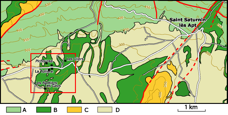
![]() The geologically workable tracts of Aptian marls in the La Tuilière area consists of three principal zones of
separate discrete outcrops
(Fig. 2
The geologically workable tracts of Aptian marls in the La Tuilière area consists of three principal zones of
separate discrete outcrops
(Fig. 2
![]() ):
):
![]() The hills of Pichouraz, the residual hillocks of La Tuilière s.s. and the hills of Les Gays are all crowned by Quaternary fluvial deposits, which truncate the underlying marls in a subhorizontal erosional disconformity.
The hills of Pichouraz, the residual hillocks of La Tuilière s.s. and the hills of Les Gays are all crowned by Quaternary fluvial deposits, which truncate the underlying marls in a subhorizontal erosional disconformity.
![]() At first sight it is not easy to understand the stratigraphic relationships of these three outcrops, which are widely separated by covered tracts and lithologically are rather uniform marls with almost no apparent stratification.
At first sight it is not easy to understand the stratigraphic relationships of these three outcrops, which are widely separated by covered tracts and lithologically are rather uniform marls with almost no apparent stratification.
![]() However, at Pichouraz an indication of the dip of the layers is detectable owing to the presence in the bluish-gray marly series of a unique stratum, 0,4-0,5 m thick, a little harder and brighter than the others, thus forming a key bed that can be traced for a certain distance. This bed has a SW dip of 15-20°, which decreases slightly westward.
However, at Pichouraz an indication of the dip of the layers is detectable owing to the presence in the bluish-gray marly series of a unique stratum, 0,4-0,5 m thick, a little harder and brighter than the others, thus forming a key bed that can be traced for a certain distance. This bed has a SW dip of 15-20°, which decreases slightly westward.
![]() In La Tuilière s.s. and Les Gays, the marls have a different appearance overall: they are dark gray-blue and less nodular than at Pichouraz; there, no hardened carbonate stratum is observable. However, the dip of this series can be determined because of the existence near the base of the succession of a ten-meter sequence showing a more or less regular succession of centimetric yellowish pyrito-limonitic beds. These thin layers show a W dip in the westernmost hillocks of La Tuilière, an E dip in the easternmost ones and a SE dip at the base of Les Gays, all three at about fifteen degrees.
In La Tuilière s.s. and Les Gays, the marls have a different appearance overall: they are dark gray-blue and less nodular than at Pichouraz; there, no hardened carbonate stratum is observable. However, the dip of this series can be determined because of the existence near the base of the succession of a ten-meter sequence showing a more or less regular succession of centimetric yellowish pyrito-limonitic beds. These thin layers show a W dip in the westernmost hillocks of La Tuilière, an E dip in the easternmost ones and a SE dip at the base of Les Gays, all three at about fifteen degrees.
![]() These observations suggest that in the La Tuilière s.l. area the Aptian marls do not reflect the general SE dip of the underlying Urgonian limestones so they must be affected by structural accidents. Thus the E-W fault on the geological sheet of Carpentras
(Fig. 2
These observations suggest that in the La Tuilière s.l. area the Aptian marls do not reflect the general SE dip of the underlying Urgonian limestones so they must be affected by structural accidents. Thus the E-W fault on the geological sheet of Carpentras
(Fig. 2
![]() ) shown in the Urgonian W of La Tuilière must extend eastward, where it could separate the Pichouraz sector from the Urgonian block of Lioux. Moreover, as indicated by the variations of dip in the thin limonitic beds, a kind of local uplift of an anticlinal nature may be centered near La Tuilière.
) shown in the Urgonian W of La Tuilière must extend eastward, where it could separate the Pichouraz sector from the Urgonian block of Lioux. Moreover, as indicated by the variations of dip in the thin limonitic beds, a kind of local uplift of an anticlinal nature may be centered near La Tuilière.
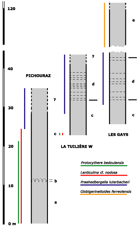
![]() In a first approach ammonites do not seem to be very helpful as a means of connecting and correlating these outcrops, because it appears that all the marls (in Pichouraz [pro parte maxima], in La Tuilière and at the beginning of the Gays section) are in the same terminal zone of the lower Aptian with Dufrenoyia furcata ( & ,
2005). The preliminary results of a detailed study of foraminifers
( et alii, this volume) and ostracods
( & , this volume), along with the results of the study of the Bedoulian and the Gargasian from Cassis-La Bédoule ( et alii,
1998, 2005) permit a discrimination between the several outcrops. In particular, at the top of the Pichouraz sequence and at the extreme base of La Tuilière s.s., we were able to locate the double datum based on
1) the quasi concomitant extinction of Lenticulina nodosa (benthic foraminifer) and Protocythere bedoulensis (ostracod) and
2) the first occurrence of Praehedbergella luterbacheri (planktonic foraminifer)
(Fig. 3
In a first approach ammonites do not seem to be very helpful as a means of connecting and correlating these outcrops, because it appears that all the marls (in Pichouraz [pro parte maxima], in La Tuilière and at the beginning of the Gays section) are in the same terminal zone of the lower Aptian with Dufrenoyia furcata ( & ,
2005). The preliminary results of a detailed study of foraminifers
( et alii, this volume) and ostracods
( & , this volume), along with the results of the study of the Bedoulian and the Gargasian from Cassis-La Bédoule ( et alii,
1998, 2005) permit a discrimination between the several outcrops. In particular, at the top of the Pichouraz sequence and at the extreme base of La Tuilière s.s., we were able to locate the double datum based on
1) the quasi concomitant extinction of Lenticulina nodosa (benthic foraminifer) and Protocythere bedoulensis (ostracod) and
2) the first occurrence of Praehedbergella luterbacheri (planktonic foraminifer)
(Fig. 3
![]() ). This enabled us to confirm that the uppermost layers at Pichouraz are the equivalent of the basal layers of La Tuilière and Les Gays, and thus that the major part of the section of Pichouraz is stratigraphically below the succession at La Tuilière-Les Gays.
). This enabled us to confirm that the uppermost layers at Pichouraz are the equivalent of the basal layers of La Tuilière and Les Gays, and thus that the major part of the section of Pichouraz is stratigraphically below the succession at La Tuilière-Les Gays.
![]() Studies in greater detail reveal that this apparently rather uniform marly succession includes a number of subtle differences upwards:
Studies in greater detail reveal that this apparently rather uniform marly succession includes a number of subtle differences upwards:
![]() a. rather indurated bluish-gray limy marls, with a nodular/conchoidal fracture; these layers occupy at least ten meters at the base of the Pichouraz section.
a. rather indurated bluish-gray limy marls, with a nodular/conchoidal fracture; these layers occupy at least ten meters at the base of the Pichouraz section.
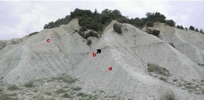
![]() b. whitish-grey clayey limestone bed, 0,4-0,5 m thick, a little harder than the contiguous marls; this bed tends to be more or less clearly distinguishable in a generally homogeneous marly series
(Fig. 4
b. whitish-grey clayey limestone bed, 0,4-0,5 m thick, a little harder than the contiguous marls; this bed tends to be more or less clearly distinguishable in a generally homogeneous marly series
(Fig. 4
![]() ). It constitutes a key-level which could be the equivalent of the "niveau blanc" as defined by
(1987) in the Vocontian Basin. Such an assignment will have to be checked by a meticulous comparative study of ammonite faunas, foraminifer and ostracod microfaunas and nannoplankton. This bed is directly overlain by a few tens of cm of laminated dark blue-gray to blackish-gray marls, definitely less indurated than those of unit a.
). It constitutes a key-level which could be the equivalent of the "niveau blanc" as defined by
(1987) in the Vocontian Basin. Such an assignment will have to be checked by a meticulous comparative study of ammonite faunas, foraminifer and ostracod microfaunas and nannoplankton. This bed is directly overlain by a few tens of cm of laminated dark blue-gray to blackish-gray marls, definitely less indurated than those of unit a.
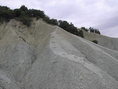
![]() c. slightly nodular bluish-gray marls, somewhat less indurated than those of unit a. They overlie the putative "niveau blanc" and its thin cover of darker marls; these marls of unit c crop out at Pichouraz over a little more than twenty meters. Their surficial patina, bluish-gray in the first ten meters, passes to yellowish-blue in the upper part of the outcrop
(Fig. 5
c. slightly nodular bluish-gray marls, somewhat less indurated than those of unit a. They overlie the putative "niveau blanc" and its thin cover of darker marls; these marls of unit c crop out at Pichouraz over a little more than twenty meters. Their surficial patina, bluish-gray in the first ten meters, passes to yellowish-blue in the upper part of the outcrop
(Fig. 5
![]() ). This yellowish patina is accompanied by an evolution of the color of the fresh rock, which becomes yellowish-gray inside. The "bluish/yellowish" contact is sufficiently well-marked that it can be followed in the topography, where it traces more or less accurately the dip of bed b.
). This yellowish patina is accompanied by an evolution of the color of the fresh rock, which becomes yellowish-gray inside. The "bluish/yellowish" contact is sufficiently well-marked that it can be followed in the topography, where it traces more or less accurately the dip of bed b.
![]() Blue-gray marls can also be seen over 8 to 10 m (under a sequence including centimetric limonitized beds, cf. unit d below) at the base of the hillocks of La Tuilière s.s. and in the basal beds of the Les Gays section. In these last two outcrops they appear much fresher than the yellowish marls of the higher part of Pichouraz, with which they correlate, as confirmed by the microfauna. It is thus possible that in Pichouraz the yellow color may be more likely to have been caused by contamination from the proximate Quaternary deposits crowning the hill, than by in situ weathering (for example of pyrite).
Blue-gray marls can also be seen over 8 to 10 m (under a sequence including centimetric limonitized beds, cf. unit d below) at the base of the hillocks of La Tuilière s.s. and in the basal beds of the Les Gays section. In these last two outcrops they appear much fresher than the yellowish marls of the higher part of Pichouraz, with which they correlate, as confirmed by the microfauna. It is thus possible that in Pichouraz the yellow color may be more likely to have been caused by contamination from the proximate Quaternary deposits crowning the hill, than by in situ weathering (for example of pyrite).
![]() d. ten meters of finely laminated blackish-blue marls, in which are more or less rhythmically inserted thin yellow to yellow-brown more or less diffuse centimetric layers, which consist of a dense accumulation of small limonitized pyrite nodules. These thin limonitic beds (a dozen in all) are separated by 0,4-0,5 to ± 1 m thick marly intervals; they can be easily overlooked for by surficial creep the contiguous marls tend to hide these nodular beds, especially after heavy rains.
d. ten meters of finely laminated blackish-blue marls, in which are more or less rhythmically inserted thin yellow to yellow-brown more or less diffuse centimetric layers, which consist of a dense accumulation of small limonitized pyrite nodules. These thin limonitic beds (a dozen in all) are separated by 0,4-0,5 to ± 1 m thick marly intervals; they can be easily overlooked for by surficial creep the contiguous marls tend to hide these nodular beds, especially after heavy rains.
![]() Such yellowish centimetric beds evoke the bentonites observed in the Gargasian and Clansayesian of the Vocontian Basin ( et alii,
1999; , 2002). Their position in the section of La Tuilière could thus correspond to that of the "Van Gogh" level, much more detailed here since it is in a more expanded series. This field assumption needs to be thoroughly checked using very detailed sedimentological, mineralogical, geochemical and paleontological analyzes
(this volume).
Such yellowish centimetric beds evoke the bentonites observed in the Gargasian and Clansayesian of the Vocontian Basin ( et alii,
1999; , 2002). Their position in the section of La Tuilière could thus correspond to that of the "Van Gogh" level, much more detailed here since it is in a more expanded series. This field assumption needs to be thoroughly checked using very detailed sedimentological, mineralogical, geochemical and paleontological analyzes
(this volume).
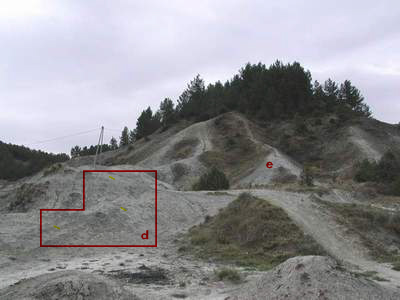
![]() Unit d has been seen in the upper part of the hillocks of La Tuilière s.s. and approximately 7 m above the base of Les Gays section
(Fig. 6
Unit d has been seen in the upper part of the hillocks of La Tuilière s.s. and approximately 7 m above the base of Les Gays section
(Fig. 6
![]() ). On the basis of preliminary micropaleontological correlations, the lower part of this sequence including thin limonitized layers should also be present at the top of the westernmost outcrop of the hill of Pichouraz. The fact that this particular lithology does not clearly appear there is probably due to the intensity of weathering of the contiguous uniformly yellowish marls of the capping (see above).
). On the basis of preliminary micropaleontological correlations, the lower part of this sequence including thin limonitized layers should also be present at the top of the westernmost outcrop of the hill of Pichouraz. The fact that this particular lithology does not clearly appear there is probably due to the intensity of weathering of the contiguous uniformly yellowish marls of the capping (see above).
![]() e. 75 m of marls, rather friable, with a dark blue-gray patina, laminated, showing a darker (blackish) fracture than in the underlying levels. This thick marly sequence does not include any lithologically individualized level which would make it possible to measure the dip of these layers. The lower part of this unit constitutes the median and higher portion of the outcrop of the eastern hills of Les Gays
(Fig. 6
e. 75 m of marls, rather friable, with a dark blue-gray patina, laminated, showing a darker (blackish) fracture than in the underlying levels. This thick marly sequence does not include any lithologically individualized level which would make it possible to measure the dip of these layers. The lower part of this unit constitutes the median and higher portion of the outcrop of the eastern hills of Les Gays
(Fig. 6
![]() ) and its upper part forms practically the whole of the westernmost hills. All these hills too are crowned by Quaternary fluvial deposits which brutally truncate the Aptian.
) and its upper part forms practically the whole of the westernmost hills. All these hills too are crowned by Quaternary fluvial deposits which brutally truncate the Aptian.
![]() In the whole of the Pichouraz La Tuilière s.s. - Les Gays area, which lies within the Aptian historical stratotypic region, a stratonomic and micropaleontological analysis of the various outcrops enabled us to establish a continuous succession of upper Bedoulian-lower Gargasian marls with a cumulative thickness of 115 to 120 meters. Only two lithological key-levels mark this otherwise uniformly marly series. One evokes the "niveau blanc" (,
1987), the other may, after further investigation, be found to represent, in a more expanded form, the "Van Gogh level" (,
2002) of the Vocontian Basin. The detailed study of this La Tuilière s.l. series is apportioned between several articles to appear in this volume. Its completion will make it possible to demonstrate that this thick sequence corresponds in fact to a relatively limited span of time within the Aptian stage. This indicates a rate of sedimentation even more rapid than that, already high, measured at Cassis-La Bédoule ( et alii,
1998; 2005) for the same stratigraphic interval.
In the whole of the Pichouraz La Tuilière s.s. - Les Gays area, which lies within the Aptian historical stratotypic region, a stratonomic and micropaleontological analysis of the various outcrops enabled us to establish a continuous succession of upper Bedoulian-lower Gargasian marls with a cumulative thickness of 115 to 120 meters. Only two lithological key-levels mark this otherwise uniformly marly series. One evokes the "niveau blanc" (,
1987), the other may, after further investigation, be found to represent, in a more expanded form, the "Van Gogh level" (,
2002) of the Vocontian Basin. The detailed study of this La Tuilière s.l. series is apportioned between several articles to appear in this volume. Its completion will make it possible to demonstrate that this thick sequence corresponds in fact to a relatively limited span of time within the Aptian stage. This indicates a rate of sedimentation even more rapid than that, already high, measured at Cassis-La Bédoule ( et alii,
1998; 2005) for the same stratigraphic interval.
![]() The authors wish to particularly thank Luc (University of Provence) for having drawn their attention to the sector of La Tuilière and to have guided them during a preliminary field excursion of the members of the "Gargasian Working Group". They also thank Jean (University of Geneva) and an anonymous reviewer for having led them, by their constructive suggestions, to improve a first version of the manuscript.
The authors wish to particularly thank Luc (University of Provence) for having drawn their attention to the sector of La Tuilière and to have guided them during a preliminary field excursion of the members of the "Gargasian Working Group". They also thank Jean (University of Geneva) and an anonymous reviewer for having led them, by their constructive suggestions, to improve a first version of the manuscript.
![]()
M.T. (1963).- Contribution à l'étude sédimentologique et paléocéanographique des terrains aptiens et albiens de la Provence aux Baronnies.- Recueil Travaux Station Marine d'Endoume, Bulletin, Marseille, n° 30, fasc. 45, pp. 95-164.
F. & Y. (2005).- Biostratigraphie et faunes d'ammonites de l'Aptien supérieur (Gargasien) de la région stratotypique de Gargas, près d'Apt (Sud-Est de la France). In: Impact environnemental sur la dynamique des populations au Crétacé.- Réunions thématiques du Groupe Français du Crétacé (Paris, 5-6 Décembre 2005), Volume des Résumés, pp. 12-15 (abstract).
B., L. & G. (1999).- Niveaux de cendres volcaniques altérées bentonites) dans les marnes bleues apto-albiennes du SE de la France: caractérisation, corrélations, extension et rôle dans la mise en place du sédiment. In: 7ème Congrès Français de Sédimentologie (Nancy).- Publication ASF, Paris, Livre 33, p. 23 (abstract).
J.J. (éd.) (1975).- Feuille Carpentras. XXXI-41.- Carte géologique de la France à 1/50.000ème.- Bureau de Recherches Géologiques et Minières, Orléans, Carte + Notice 24 p.
H. (1975).- Sélaciens et Holocéphale du Gargasien de la région de Gargas (Vaucluse).- Géologie méditerranéenne, Marseille, vol. 2, n° 3, pp. 115-134.
L. (2002).- Litho-, bio-, et chronostratigraphie comparées dans le bassin Vocontien à l'Aptien.- Thèse de l'Université, Université des Sciences et Technologies de Lille-I, 451 p.
G. (1987). Dynamique du Bassin subalpin méridional de l'Aptien au Cénomanien.- Mémoires des Sciences de la Terre, École des Mines de Paris, n° 4, 370 p.
G. (1975).- Contribution à l'étude stratigraphique et sédimentologique de l'Aptien supérieur de Provence.- Thèse de Spécialité, Université de Provence, Aix-Marseille II, 92 p.
J. (1932).- Sur l'extension des faciès urgoniens dans les monts de Vaucluse.- Bulletin de la Société géologique de France, Paris, (sér. 5), vol. II, pp. 445-464.
J. (1944).- Contribution à l'étude paléogéographique du Crétacé inférieur dans le Sud-Est de la France.- Bulletin de la Carte géologique de France, Paris, vol. 44, n° 215, pp. 1-62.
W. (1910).- Das bathyale Palaeocretacicum im südöstlichen Frankreich. Lethaea geognostica, pt. 2, Das Mesozoicum. Vol. 3, Kreide. Sect. 1, 2d fasc., Unterkreide.- Stuttgart, 398 p.
M. (1965).- Révision des stratotypes de l'Aptien: Gargas (Vaucluse). In: Colloque sur le Crétacé inférieur (Lyon, 1963).- Mémoires du Bureau de Recherches Géologiques et Minières, Orléans, n° 34, pp. 201-214.
M., J.-P., G., W., P., J.A., E. & M. (1998). Le stratotype historique de lAptien (région de Cassis-La Bédoule, SE France): synthèse stratigraphique.- Géologie méditerranéenne, Marseille, t. XXV, N° 3-4, pp. 289-298.
M., G. & J.-P. (2005).- The Gargasian (Middle Aptian) strata from Cassis-La Bédoule (Lower Aptian historical stratotype, SE France): planktonic and benthic foraminiferal assemblages and biostratigraphy [Le Gargasien (Aptien moyen) de Cassis-La Bédoule (stratotype historique de l'Aptien inférieur, SE France) : associations et biostratigraphie des Foraminifères benthiques et planctoniques].- Carnets de Géologie / Notebooks on Geology, Brest, Article 2005/02 (CG2005_A02), pp. 1-20.
G.S. (ed.) (2001).- Characterisation and correlation from Tercis-les-Bains (Landes, SW France) to Europe and other continents.- IUGS Special Publication (Monograph) Series 36; Developments in Palaeontology and Stratigraphy, 19, Elsevier, Amsterdam, xxviii + 881 pp.
G.S., S., F. & J. (2004).- Stage boundaries, global stratigraphy, and the time scale: towards a simplification.- Carnets de Géologie / Notebooks on Geology, Brest, Article 2004/02 (CG2004_A02), pp. 1-12.
H.J. (1958).- Les Ostracodes de l'Aptien-Albien d'Apt.- Revue de l'Institut français du Pétrole, Paris, vol. 13, n° 11, pp. 1499-1537.
A. d' (1840).- Paléontologie Française. Tome I, Terrains crétacés, Céphalopodes.- Publ. Arthus Bertrand, Paris, 662 p.
F.J. (1865).- Note sur une dent de l'étage aptien des environs d'Apt, appartenant à un Notidanus non décrit.- Mémoires de l'Académie de Vaucluse, Avignon, pp. 67-70.
E. (1971a).- Géologie du pays d'Apt (première partie).- Bulletin du Bureau de Recherches Géologiques et Minières, Orléans, (sér. 2), pt. IV, n° 3, pp. 39-57.
E. (1971b).- Géologie du pays d'Apt (première partie).- Bulletin du Bureau de Recherches Géologiques et Minières, Orléans, (sér. 2), pt. IV, n° 4, pp. 57-114.
P. & R. (2004). Les Dufrenoyia (Ammonoidea) de la zone à Furcata (Aptien inférieur) du Sud-Est de la France.- Annales du Museum d'Histoire naturelle de Nice, Nice, vol. XVIII, pp. 21-55.
![]()
Click on thumbnail to enlarge the image.
Figure 1: Topographic map of the surroundings of Apt (Vaucluse, SE France) locating the hamlet of La Tuilière.
Click on thumbnail to enlarge the image.
Figure 2: Geologic map (from Carpentras sheet at 50.000th: , 1975) showing (red rectangle) the Aptian outcrops of Pichouraz, La Tuilière s.s. and Les Gays. A. Urgonian limestones; B. Aptian marls; C. Cenozoic (pro parte) series; D. Quaternary deposits; faults (in red).
Click on thumbnail to enlarge the image.
Figure 3: Correlation of the logs of Pichouraz, La Tuilière W and Les Gays sections.
Click on thumbnail to enlarge the image.
Figure 4: Pichouraz outcrop, showing the bed b ("niveau blanc") and the contiguous marls (units a and c).
Click on thumbnail to enlarge the image.
Figure 5: Pichouraz, unit c.
Click on thumbnail to enlarge the image.
Figure 6: Eastern part of the Les Gays outcrop, showing unit d (framed) and the lower layers of unit e.
![]()