![]()
![]()
M., V. & F. de (2007).- Palynological and geochemical data in peat sediments alongside an old (Roman or Merovingian) paved road in the Hautes-Fagnes. In: P. & E. (eds.), Recent Advances in Palynology.- Carnets de Géologie / Notebooks on Geology, Brest, Memoir 2007/01, Abstract 09 (CG2007_M01/09)
![]() Palynology; geochemistry; peat; Holocene; Belgium; Roman; Merovingian; road.
Palynology; geochemistry; peat; Holocene; Belgium; Roman; Merovingian; road.
![]() Palynologie ; géochimie ;
tourbe ; Holocène ; Belgique ; Romain ; Mérovingien ; route.
Palynologie ; géochimie ;
tourbe ; Holocène ; Belgique ; Romain ; Mérovingien ; route.
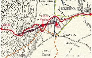
![]() In 1768, a report to her Majesty Empress Marie-Thérèse of Austria,
concerning the Duchies of Limburg and Luxemburg, indicated that an old paved road, then covered by peat and vegetation,
linked the regions of Eupen and Sourbrodt (now in area called Hautes-Fagnes, in the province
of Liège in eastern Belgium). At that time, only a bad trail wound across the
region and the users of this trail were obliged to pay toll to the Liège Principality. The paved road, after restoration, would have allowed direct
communication between the duchies
(Fig. 1
In 1768, a report to her Majesty Empress Marie-Thérèse of Austria,
concerning the Duchies of Limburg and Luxemburg, indicated that an old paved road, then covered by peat and vegetation,
linked the regions of Eupen and Sourbrodt (now in area called Hautes-Fagnes, in the province
of Liège in eastern Belgium). At that time, only a bad trail wound across the
region and the users of this trail were obliged to pay toll to the Liège Principality. The paved road, after restoration, would have allowed direct
communication between the duchies
(Fig. 1 ![]() ).
).
![]() The paved road, traditionally known to the local inhabitants as the "Pavé de Charlemagne", was never restored and its detailed layout
was forgotten until the early 1930's when the abbot J. rediscovered and described (,
1934) its remarkable structure between the sites of "Croix
Mockel" and "Wez" (Fig. 1
The paved road, traditionally known to the local inhabitants as the "Pavé de Charlemagne", was never restored and its detailed layout
was forgotten until the early 1930's when the abbot J. rediscovered and described (,
1934) its remarkable structure between the sites of "Croix
Mockel" and "Wez" (Fig. 1 ![]() ).
).
![]() The road was believed to have a Roman origin until several 14C dates
obtained at the "Croix
Mockel" site (,
1981) suggested a Merovingian age (between A.D. 460 and A.D.
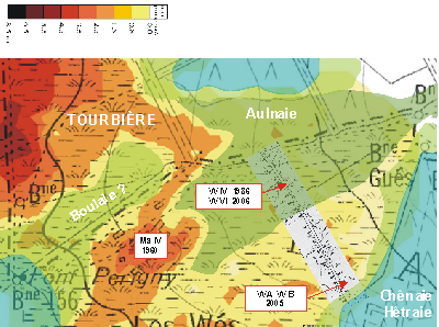
885). Pollen analyses performed in the Wez site (Fig. 2
The road was believed to have a Roman origin until several 14C dates
obtained at the "Croix
Mockel" site (,
1981) suggested a Merovingian age (between A.D. 460 and A.D.
885). Pollen analyses performed in the Wez site (Fig. 2 ![]() ) by
(1960), &
(1986) and more recently by et alii
(2005) generated contradictory conclusions.
(1960) concluded that the pollen analysis of the peat below the road suggested an age considered to be too
old for, but one 14C date supported a Roman age. &
(1986), introduced a new method of dating by pollen analysis of the peaty layers contaminated by mineral dust alongside the road and proposed a Merovingian age. The
latest contribution was obtained from a trench made perpendicular to, but alongside the paved road, in a new site investigated by
(2005) near the southern border of the
Wez. Two profiles were studied (W A and W B) using geochemical ( et alii,
2005) as well as palynological ( et alii,
2005) techniques on the samples. Helped by several 14C dates, they came to the conclusion that the road was built between A.D. 210-390 and A.D. 380-540, using calibration method Oxcal 3.8. These two dates were then recalibrated using
the calibration method Oxcal 3.10 to give an interval ranging from A.D.130-380 to A.D. 350-540. It was then decided to use the same techniques on a new core (W VI) taken at the site investigated by &
(1986).
) by
(1960), &
(1986) and more recently by et alii
(2005) generated contradictory conclusions.
(1960) concluded that the pollen analysis of the peat below the road suggested an age considered to be too
old for, but one 14C date supported a Roman age. &
(1986), introduced a new method of dating by pollen analysis of the peaty layers contaminated by mineral dust alongside the road and proposed a Merovingian age. The
latest contribution was obtained from a trench made perpendicular to, but alongside the paved road, in a new site investigated by
(2005) near the southern border of the
Wez. Two profiles were studied (W A and W B) using geochemical ( et alii,
2005) as well as palynological ( et alii,
2005) techniques on the samples. Helped by several 14C dates, they came to the conclusion that the road was built between A.D. 210-390 and A.D. 380-540, using calibration method Oxcal 3.8. These two dates were then recalibrated using
the calibration method Oxcal 3.10 to give an interval ranging from A.D.130-380 to A.D. 350-540. It was then decided to use the same techniques on a new core (W VI) taken at the site investigated by &
(1986).
![]() It is important to note the environmental differences between the site of profiles W A and W B and the site of cores W IV and
VI when the road was built. Alnus (alder) makes up to 50% of the total pollen sum in the lower part of W IV and W VI
(Figs. 4
It is important to note the environmental differences between the site of profiles W A and W B and the site of cores W IV and
VI when the road was built. Alnus (alder) makes up to 50% of the total pollen sum in the lower part of W IV and W VI
(Figs. 4 ![]() - 5
- 5 ![]() )
but is smaller in amount and range of variation in profiles W A and W B.
)
but is smaller in amount and range of variation in profiles W A and W B.
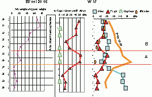
![]() However for dating purposes, the regional pollen rain is of the greatest importance as shown by
(1960) in his profile Ma IV. Taken in a non-wooded raised bog, regional pollen rain is assumed to be at a
maximum. (1960) identified 3 of the 4 maxima of Fagus (beech) pollen
(Fig. 3
However for dating purposes, the regional pollen rain is of the greatest importance as shown by
(1960) in his profile Ma IV. Taken in a non-wooded raised bog, regional pollen rain is assumed to be at a
maximum. (1960) identified 3 of the 4 maxima of Fagus (beech) pollen
(Fig. 3 ![]() ) recorded by
(1950) in another peat-bog some 10 km to the north. However,
the dates given by
(1950) were interpolated without 14C control,
assuming a constant accumulation rate of the peat and and therefore are of low reliability.
Therefore, the correlation made by (1960)
and the dates given
(Fig. 3
) recorded by
(1950) in another peat-bog some 10 km to the north. However,
the dates given by
(1950) were interpolated without 14C control,
assuming a constant accumulation rate of the peat and and therefore are of low reliability.
Therefore, the correlation made by (1960)
and the dates given
(Fig. 3 ![]() )
are also of low reliability. The presence/absence or frequency of Carpinus
(hornbeam) is the only criterion for discriminating between FI, FII and FIII. (1960) calculated all the percentages on the sum of arboreal pollen
(AP).
)
are also of low reliability. The presence/absence or frequency of Carpinus
(hornbeam) is the only criterion for discriminating between FI, FII and FIII. (1960) calculated all the percentages on the sum of arboreal pollen
(AP).
![]() Core W IV was sampled at 2.5 cm intervals and macerated for pollen analysis, for recording of ash weight/dry peat weight and for isolation of the first occurrence of small (1mm or less) fragments of quartzite in the calcined peat. The new core W VI was sampled
every cm and treated like W IV. The same samples were analyzed by geochemistry for later comparison with the data observed in profile W B.
Core W IV was sampled at 2.5 cm intervals and macerated for pollen analysis, for recording of ash weight/dry peat weight and for isolation of the first occurrence of small (1mm or less) fragments of quartzite in the calcined peat. The new core W VI was sampled
every cm and treated like W IV. The same samples were analyzed by geochemistry for later comparison with the data observed in profile W B.
![]() In core W IV, the sudden decline
in the percentage of Alnus pollen was explained by &
(1986) as the result of the opening of the paved road through the wooded peat-bog
associated with the Helle brook. The sudden decline is indeed accompanied in the core
by an increase of ash content and by the first occurrence in the calcined peat of small
(1 mm or less) fragments of quartzite. It was also considered that the paved road was built there for the first time.
In core W VI the decline in the percentage of Alnus pollen is again
taken to indicate the construction of the new road. However, the decline is more
gradual than in W IV because of the closer sampling.
In core W IV, the sudden decline
in the percentage of Alnus pollen was explained by &
(1986) as the result of the opening of the paved road through the wooded peat-bog
associated with the Helle brook. The sudden decline is indeed accompanied in the core
by an increase of ash content and by the first occurrence in the calcined peat of small
(1 mm or less) fragments of quartzite. It was also considered that the paved road was built there for the first time.
In core W VI the decline in the percentage of Alnus pollen is again
taken to indicate the construction of the new road. However, the decline is more
gradual than in W IV because of the closer sampling.
![]() The abundance of Alnus pollens in this site along the Helle had to be taken into account when calculating the percentages of
pollen from other tree species provided by forests dominating the landscape outside the peat-bogs. Not only
is the Alnus pollen rain locally more abundant than the regional pollen rain
from the surrounding forests, but also the local density of Alnus trees may
have acted as a shelter from the regional pollen rain. We have therefore recalculated in both cores the percentages of Fagus and Carpinus in the arboreal pollen sum less Alnus in order to reduce the importance of non-arboreal and local pollen rain. This was not done by &
(1986) who had come to the conclusion that the Fagus maximum above the decline of Alnus,
as it was less important than the maximum visible below the decline of Alnus,
corresponded to the FII of
(1960). The recalculation of & 's
(1986) diagram however shows
(Fig. 5
The abundance of Alnus pollens in this site along the Helle had to be taken into account when calculating the percentages of
pollen from other tree species provided by forests dominating the landscape outside the peat-bogs. Not only
is the Alnus pollen rain locally more abundant than the regional pollen rain
from the surrounding forests, but also the local density of Alnus trees may
have acted as a shelter from the regional pollen rain. We have therefore recalculated in both cores the percentages of Fagus and Carpinus in the arboreal pollen sum less Alnus in order to reduce the importance of non-arboreal and local pollen rain. This was not done by &
(1986) who had come to the conclusion that the Fagus maximum above the decline of Alnus,
as it was less important than the maximum visible below the decline of Alnus,
corresponded to the FII of
(1960). The recalculation of & 's
(1986) diagram however shows
(Fig. 5 ![]() ) that this Fagus maximum could
also correspond to the FI.
) that this Fagus maximum could
also correspond to the FI.
![]() The Fagus
maximum in the new core W VI, immediately above the Alnus decline might therefore correspond to the FI of
(1960), here called zone A
(Fig. 4
The Fagus
maximum in the new core W VI, immediately above the Alnus decline might therefore correspond to the FI of
(1960), here called zone A
(Fig. 4 ![]() ).
If so, the opening of the road through the Alnus wooded peat-bog might be Roman,
not Merovingian.
).
If so, the opening of the road through the Alnus wooded peat-bog might be Roman,
not Merovingian.
![]() However the drastic increase of ash content (> 50 %) in dry peat is clearly above that
of the Fagus maxima in both cores. Above the Fagus maximum in the new core W VI, identified now as zone B
(Fig. 4
However the drastic increase of ash content (> 50 %) in dry peat is clearly above that
of the Fagus maxima in both cores. Above the Fagus maximum in the new core W VI, identified now as zone B
(Fig. 4 ![]() ), a continuous occurrence of Filicales spores
implies a superficial more mineralized peat. At the same level occur very abundant
cenospheres. They are known to be ash particles resulting from incomplete high-temperature combustion of peat ( &
1996; & ,
1979).
), a continuous occurrence of Filicales spores
implies a superficial more mineralized peat. At the same level occur very abundant
cenospheres. They are known to be ash particles resulting from incomplete high-temperature combustion of peat ( &
1996; & ,
1979).
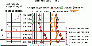
![]() In Figure 6
In Figure 6 ![]() (a simplified diagram of profile WB), the pollen percentages of Fagus and Carpinus were recalculated on the arboreal pollen sum only, to reduce the local importance of non arboreal pollen rain in the pollen diagram. This profile W B has been dated by five successive 14C dates. The four lower dates, being very close, allowed recalibration using the wiggle-match dating program Bcal
(Figs. 6
(a simplified diagram of profile WB), the pollen percentages of Fagus and Carpinus were recalculated on the arboreal pollen sum only, to reduce the local importance of non arboreal pollen rain in the pollen diagram. This profile W B has been dated by five successive 14C dates. The four lower dates, being very close, allowed recalibration using the wiggle-match dating program Bcal
(Figs. 6 ![]() - 7
- 7 ![]() ). The maxima of Fagus were attributed to the FI based on their calibrated 14C age interval of A.D. 86 A.D. 258. The site W B was not situated in an Alnus wooded peat-bog and therefore the supposed man-made Alnus decline could not be
detected. The ash content in dry peat increases suddenly between 79-80cm and 81-82cm i.e.
within the time limit of A.D. 131 and A.D. 540.
). The maxima of Fagus were attributed to the FI based on their calibrated 14C age interval of A.D. 86 A.D. 258. The site W B was not situated in an Alnus wooded peat-bog and therefore the supposed man-made Alnus decline could not be
detected. The ash content in dry peat increases suddenly between 79-80cm and 81-82cm i.e.
within the time limit of A.D. 131 and A.D. 540.
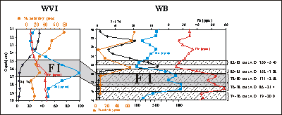
![]() The drastic increase of silica content between 81 and 82 cm (between A.D. 152 and A.D. 540) in
the W B profile attests the presence of quartzite fragments linked to the building of the paved road and
the beginning of its use
(Fig. 7
The drastic increase of silica content between 81 and 82 cm (between A.D. 152 and A.D. 540) in
the W B profile attests the presence of quartzite fragments linked to the building of the paved road and
the beginning of its use
(Fig. 7 ![]() ). This characteristic is also present in W VI although the Si increase in W VI is more progressive than in W B. Moreover, the appearance of Filicales is abrupt in W B while progressive in W VI. These discrepancies between W B and W VI profiles suggest either a difference in the accumulation rate of peat, or a difference in the recording of quartzite fragments. Indeed, the deposition of quartzite fragments on a peat surface is completely chaotic. It is thus possible
not only to have a difference in quantity but also in size (small then large in W VI, while
all are large in W B) of quartzite fragments, resulting in a difference in Si profiles. However, to clarify this
point 14C dating needs be performed in W VI.
). This characteristic is also present in W VI although the Si increase in W VI is more progressive than in W B. Moreover, the appearance of Filicales is abrupt in W B while progressive in W VI. These discrepancies between W B and W VI profiles suggest either a difference in the accumulation rate of peat, or a difference in the recording of quartzite fragments. Indeed, the deposition of quartzite fragments on a peat surface is completely chaotic. It is thus possible
not only to have a difference in quantity but also in size (small then large in W VI, while
all are large in W B) of quartzite fragments, resulting in a difference in Si profiles. However, to clarify this
point 14C dating needs be performed in W VI.
![]() Trace elements geochemistry shows significant increases in lead and zinc beginning at 70 cm in W B and at 29 cm in W VI. Lead isotopes analyses were performed on some samples presenting high concentrations of lead and zinc (between 70 cm and 94 cm in W B). These samples show isotopic ratios similar to isotopic ratio of lead-zinc ores located approximately 15-20 km to the north-northwest, in the Verviers synclinorium. Therefore, it is possible to suggest the hypothesis that the road could have been used to carry lead-zinc ores from
the Verviers-Aachen area through the Hautes-Fagnes region, and then perhaps
south-southwest to Trier, an important metal working centre at these times.
Trace elements geochemistry shows significant increases in lead and zinc beginning at 70 cm in W B and at 29 cm in W VI. Lead isotopes analyses were performed on some samples presenting high concentrations of lead and zinc (between 70 cm and 94 cm in W B). These samples show isotopic ratios similar to isotopic ratio of lead-zinc ores located approximately 15-20 km to the north-northwest, in the Verviers synclinorium. Therefore, it is possible to suggest the hypothesis that the road could have been used to carry lead-zinc ores from
the Verviers-Aachen area through the Hautes-Fagnes region, and then perhaps
south-southwest to Trier, an important metal working centre at these times.
![]() We wish to express our gratitude to F. (Brussels), B.
(Nottingham) and N. (Modesto) for improving the paper. This work was supported by a F.N.R.S.
grant (geochemistry and datings) and a.s.b.l. "Parc Naturel Hautes
Fagnes-Eifel" (datings). Nathalie (ULg)
is also acknowledged for her comments and support. François de
has a F.R.I.A. fellowship.
We wish to express our gratitude to F. (Brussels), B.
(Nottingham) and N. (Modesto) for improving the paper. This work was supported by a F.N.R.S.
grant (geochemistry and datings) and a.s.b.l. "Parc Naturel Hautes
Fagnes-Eifel" (datings). Nathalie (ULg)
is also acknowledged for her comments and support. François de
has a F.R.I.A. fellowship.
J. (1934).- La Via Mansuerisca.- LAntiquité classique, Louvain-la-Neuve, vol. 3, p. 333-383.
P. & M. (1998).- Topographie détaillée de la voie mérovingienne (la Via Mansuerisca ?), enfouie dans la fagne des Wés.- Hautes Fagnes, Verviers, vol. 230, p. 45-52.
M.-H. (1981).- La "Via Mansuerisca", étude archéologique du tracé et des structures.- Archaeologia Belgica, Bruxelles, vol. 235, p. 5-31.
M.-H. (2005).- Nouvelles recherches archéologiques pluridisciplinaires sur le parcours de la voie médiévale dite la Via Mansuerisca et découverte dun véhicule dans la Fagne Rasquin, Waimes.- Archaeologia Mediaevalis, Bruxelles, vol. 28, p. 6-9.
C. & M. (1986).- La Via Mansuerisca, enfouie dans la fagne des Wez, est mérovingienne , pas romaine.- Hautes Fagnes, Verviers, vol. 184, p. 93-102.
E.-M. (1960).- Recherches palynologiques sur le plateau des Hautes-Fagnes.- Bulletin de la Société Royale de Botanique de Belgique, Meise, vol. 92/1-2, p. 157-196.
N. (1950) - Chemins anciens, anciennes limites.- Hautes Fagnes, Verviers, vol. 1, p. 18-22.
J.J. & E.D. (1979).- Morphologies and origin of elemental carbon in the environment.- Science, Washington, vol. 206, p. 563-565
M.A. & J. (1996).- "Linotolypidae" and cenospheres. In: J. & D.C. (ed.), Palynology: principles and applications.- American Association of Stratigraphic Palynologists Foundation, College Station, vol. 1, p. 357-359.
F. (1950).- Zum postglazialen Wald- und Moorentwickelung im Hohen Venn.- Decheniana, Bonn, vol. 104, p. 81-93.
V., N., S., M. & F. de (2005).- Pourquoi une route pavée (Via Mansuerisca ?) au travers des tourbières ? Enfin une hypothèse qui tient la route.- Hautes Fagnes, Verviers, vol. 258, p. 22-24.
M., V., N., S. & F. de (2005).- La route pavée au travers des tourbières de la fagne des Wez (Via Mansuerisca ?) est-elle romaine ou mérovingienne ? La vérité est-elle ... à mi-chemin ?- Hautes Fagnes, Verviers, vol. 259, p. 20-25.
Click on thumbnail to enlarge the image.
Figure 1: Map drawn by Cornelius in 1778 (after , 1950). Dotted lines: boundaries between the four Duchies and Principalities which were meeting in the Hautes-Fagnes. The toll fees were to be paid at the site named here "Croix Mockel".
Click on thumbnail to enlarge the image.
Figure 2: The site "Les Wés" or "Wez" on the right side of the small brook "Helle". Grey shaded area: layout of the paved road ( & , 1998). Other colours: hypothetical vegetation cover before the road building, based on the soil characteristics and on pollen data. "Aulnaie", "Boulaie", "Chênaie", and "Hêtraie" are woods dominated respectively by Alnus, Betula, Quercus and Fagus. Investigated sites are reported (see text for details).
Click on thumbnail to enlarge the image.
Figure 3: Simplified 5 cm interval pollen diagram Ma IV (, 1960) with percentages calculated on arboreal pollen sum (AP). Dates of maxima of Fagus pollens based on the pollen analysis of another peat bog, 10 km to the north (, 1950). The "?" indicates a possible equivalent of core W VI as explained in text.
Click on thumbnail to enlarge the image.
Figure 4: On the right: simplified pollen diagram of core W VI (percentage calculated on total pollen sum). On the left: percentages of ash in dry peat, and levels with abundant cenospheres. In the middle: percentages of Fagus and Carpinus recalculated on arboreal pollen sum less Alnus in order to reduce the importance of non-arboreal and local pollen rain.
Click on thumbnail to enlarge the image.
Figure 5: On the right: simplified pollen diagram of core W IV (after & , 1986) (percentage calculated on total pollen sum). On the left: percentages of ash in dry peat. In the middle: percentages of Fagus and Carpinus recalculated on arboreal pollen sum less Alnus in order to reduce the importance of non-arboreal and local pollen rain.
Click on thumbnail to enlarge the image.
Figure 6: On the right: simplified pollen diagram of profile W B ( et alii, 2005) (percentage calculated on total pollen sum). On the left: percentage of ash in dry peat and calibrated 14C intervals. In the middle: percentages of Fagus and Carpinus recalculated on arboreal pollen sum in order to reduce the importance of non-arboreal pollen rain. Note that the samples in profile W B are measured from the base of the peat layer.
Click on thumbnail to enlarge the image.
Figure 7: Comparison of geochemical data in new core W VI and profile W B ( et alii, 2005) in the case the maximum of Fagus FI is confirmed in W VI.
Click on thumbnail to enlarge the image.
Pollen diagram of core W VI. Percentages of all pollens and spores (except Sphagnum) on the total sum. Curves of pollens from Carpinus, Cerealia, Plantago, Calluna, other Ericaceae and spores of Polypodium and Pteridium are 5x exaggerated.