![]()
Contents
[1. Introduction] [2. History and ...]
[3. The "Vraconnian fauna" and ...]
[4. ... some representative areas] [5. ... from 1868 to 1963]
[6. ... in 2008] [7. Proposal ...] [Bibliographic references]
[Figures] and ... [Plates]
![]()
Preliminary remarksDuring a Colloquium of the "Groupe Français du Crétacé" [French Group working on the Cretaceous] held in Paris in December 2006 an impromptu discussion began regarding an old division of geologic time, officially abandoned but still used in a practical way: the Vraconnian. The opinions expressed were surprisingly in agreement regarding the fact that the thickness of Vraconnian strata is frequently greater than that of the stage of which it is officially a division: the Albian. Because I had written in French a "Plaidoyer pour un étage Vraconnien entre l'Albien sensu stricto et le Cénomanien (système Crétacé)" [Justification for a Vraconnian stage between the Albian sensu stricto and the Cenomanian (Cretaceous system)] published in 2002 by the "Académie Royale de Belgique" [Royal Academy of Belgium], Bruno , Professor at the "Université de Bretagne Occidentale" [University of Western Brittany] in Brest, current President of the "Comité Français de Stratigraphie" [French Committee on Stratigraphy] and editor of the journal Carnets de Géologie / Notebooks on Geology, proposed the publication "online" of an English version of this synthesis summarizing the state of current knowledge on the Vraconnian. Its purpose to insure among our English-speaking colleagues the broader diffusion of a discussion paper on the Vraconnian in the hope of starting new multidisciplinary studies on this old chronostratigraphic division, and, why not in the end, a proposal for its rehabilitation to an "official" status. The novelty of this approach was attractive at once, but to carry it out it was not simple because of my limited knowledge of English and technical problems in adapting the figures and of © copyrights belonging to the Académie Royale de Belgique. Its publication on line today "in English" shows that all of these questions have been resolved. So I make a point of thanking in particular:
To all, my thanks, Francis Calais, December 2, 2007 |
The geological scale for the middle Cretaceous currently used throughout the world was proposed by Alcide d' in the XIXth century between the years 1842 and 1847 and establishes the succession of stages as Albian, Cenomanian and Turonian. In 1868 proposed that a supplemental chronostratigraphic division be intercalated between the Albian and the Cenomanian: the Vraconnian stage. This term was not generally accepted and after a period when it was referred to by (1936) as a substage constituting the upper part of the Albian, as an equivalent of the Stoliczkaia dispar ammonite Zone, its abandonment was "recommended" by the Conference on the Lower Cretaceous held in Lyon in 1963. The conditions that led to this "decision" will be discussed herein.
Historically, for almost a century the Vraconnian was studied only in the condensed levels of the platform where ammonites are abundant, but the succession is thin and not mappable. The type section of the Vraconnian in the Vaud canton of Switzerland is only 2 meters thick. In France the situation is the same in the northern Alps, in most of central Europe, in Russia, in the Crimea, and as far as the Caspian sea.
The examination of a certain number of sections located in other parts of the world: in the southeastern basin of France (Salazac, Marcoule, Mont-Risou), in the Anglo-Paris basin (Folkestone, Merstham, Grandpré), in the Mons basin (Harchies, Strépy-Thieu), at the southern edge of the Tethys in central Tunisia (Kaalat Senan), in Madagascar (Diégo Suarez) and North America in California (Dry Creek) demonstrates, however, that in a number of regions of the globe the sedimentary record of the Vraconnian is sometimes rather considerable, often much more important than that of the Albian sensu stricto.
In addition, the Vraconnian represents a very important eustatic event between an Albian transgression and the great Cenomanian transgression (third order cycle and the peak of transgression in a second order cycle). It involves a period of rapid ecologic expansion both as regards the macrofauna (ammonites in particular) and microfauna (planktonic foraminifera). These are the main reasons why a rehabilitation of the Vraconnian as a true stage is proposed here.
The Vraconnian in 2008
- Mortoniceras (Mortoniceras) fallax IZ;
- Mortoniceras (Subschloenbachia) perinflatum TRZ;
- Arrhaphoceras (Praeschloenbachia) briacensis IZ.
However, note that the first occurrence of the planktonic foraminifer Rotalipora globotruncanoides which marks the Vraconnian-Cenomanian boundary is just below the upper limit of the A. (P.) briacensis Zone. As A. (P.) briacensis is one of the Hoplitidae of which the geographic distribution is confined to the North European province of the Boreal realm an alternative solution to the existing zonation in the future could be founded on the phyletic line of the cosmopolitan Stoliczkaiinae with the succession Neophlycticeras (Neophlycticeras) blancheti, Stoliczkaia (Stoliczkaia) dispar, Stoliczkaia (Lamnayella) tetragona or S. (Shumarinaia) africana.
N.B. Many have correlated the Vraconnian with the range of the Stoliczkaia dispar Zone auct.. In fact, S. dispar is confined to the M. (S.) perinflatum TRZ.
Cretaceous; Albian; Cenomanian; Vraconnian stage; ammonites; foraminifera; sequence stratigraphy.
F. (2008).- Support for a Vraconnian Stage between the Albian sensu stricto and the Cenomanian (Cretaceous System).- Carnets de Géologie / Notebooks on Geology, Brest, Memoir 2008/02 (CG2008_M02)
Plaidoyer pour un étage Vraconnien entre l'Albien sensu stricto et le Cénomanien (système Crétacé).- Le calendrier géologique en usage actuellement dans le monde pour la partie moyenne du Crétacé a été construit au XIXème siècle, entre les années 1842 et 1847 par Alcide d' et montre la succession des étages Albien, Cénomanien et Turonien. En 1868, une division chronostratigraphique supplémentaire, intercalée entre l'Albien et le Cénomanien, a été proposée par : l'étage Vraconnien. Ce terme n'a pas été pérennisé et, après avoir été ramené dans un premier temps au rang d'un sous-étage formant la partie supérieure de l'étage Albien par (1936), son abandon a été "recommandé" lors du Colloque sur le Crétacé inférieur tenu à Lyon en 1963. On développera la façon dont la "décision" a été prise.
Historiquement, le Vraconnien a été étudié pendant près d'un siècle uniquement dans des niveaux condensés de plate-forme, riches en ammonites mais peu épais et qui ne se prêtaient pas à une cartographie. Dans le gisement-type de La Vraconne situé dans le canton de Vaud en Suisse par exemple, le Vraconnien mesure seulement 2 mètres d'épaisseur. La situation est la même en France dans le Nord des Alpes, dans une grande partie de l'Europe centrale, en Russie, en Crimée et jusqu'à la mer Caspienne.
L'examen d'un certain nombre de coupes réparties dans d'autres parties du monde : dans le bassin du Sud-Est de la France (Salazac, Marcoule, Mont-Risou), dans le bassin anglo-parisien (Folkestone, Merstham, Grandpré), dans le bassin de Mons (Harchies, Strépy-Thieu), sur la marge méridionale de la Téthys en Tunisie centrale (Kalaat Senan), à Madagascar (Diégo) et en Amérique du Nord en Californie (Dry Creek), montre cependant que dans de nombreuses régions du globe, l'enregistrement sédimentaire du Vraconnien est parfois considérable, souvent beaucoup plus important que celui de l'Albien sensu stricto. En outre, le Vraconnien correspond à un événement eustatique global d'une réelle importance entre une transgression albienne et une grande transgression cénomanienne (cycle de 3ème ordre et pic de transgression d'un cycle de second ordre). Enfin il s'agit d'une période d'épanouissement écologique à la fois en ce qui concerne les macrofaunes (ammonites en particulier) et les microfaunes (foraminifères planctoniques). Ce sont les principales raisons pour lesquelles une réhabilitation du Vraconnien comme étage à part entière est proposée ici.
Le Vraconnien en 2008
- IZ à Mortoniceras (Mortoniceras) fallax ;
- TRZ à Mortoniceras (Subschloenbachia) perinflatum ;
- IZ à Arrhaphoceras (Praeschloenbachia) briacensis.
A. (P.) briacensis étant un Hoplitidae dont la répartition géographique est limitée à la province nord-européenne du domaine boréal, une solution alternative à la zonation actuelle pourrait être fondée dans l'avenir sur la lignée phylétique des Stoliczkaiinae, cosmopolites, avec la succession Neophlycticeras (Neophlycticeras) blancheti, Stoliczkaia (Stoliczkaia) dispar, Stoliczkaia (Lamnayella) tetragona ou S. (Shumarinaia) africana.
Crétacé ; Albien ; Cénomanien ; étage Vraconnien ; ammonites ; foraminifères ; stratigraphie séquentielle.
The geological time scale for the middle Cretaceous in current use worldwide was constructed in the XIXth century by Alcide d' who in 1842 created the Albian and Turonian stages, and then in 1847 the Cenomanian stage representing the lower portion of the Turonian of 1842. D''s innovative idea for the creation of chronostratigraphic stages quickly excited a broad adhesion by the scientific community. Its major interest lay in the definition of stages by their paleontologic content and not by a succession of "lithologic units" of which the composition could vary greatly even in the same basin, and a fortiori in different sedimentary basins. It was a way open to standardize geological time scales at a local level. In this spirit d' published in 1850 in the "Prodrome de Paléontologie" a list of the species assigned to each of the named stages, and in 1852 his "Cours élémentaire de Paléontologie et de Géologie stratigraphique" revised, summarized and synthesized the concept.
In the second half of the XIXth century emulation of d''s work caused a number of authors to propose supplementary chronostratigraphic divisions. Some had the value of a stage, such as the Vraconnian, intercalated between the Albian and Cenomanian (, 1868). Others were regarded as simple substages of the Cenomanian, for example the Tavien (, 1876) or as substages of the Turonian with the Angoumien (, 1857), the Provencien (, 1857), the Ligérien (, 1869), the Ucétien (, 1876) and the Saumurien (de , 1901). These terms have not been adopted and today their usage is abandoned in accordance with the recommendations of the Conference on the Upper Cretaceous held in Dijon in 1959 (, 1960) and again by the Conference on the Lower Cretaceous organized in Lyon in 1963 (, 1965a).
If most of the "supplementary" divisions proposed in the past were linked to regional facies and merit only a mention in the history of the sciences, the Vraconnian case seems different. It was created by in 1868 because of the special characteristics of the ammonites present in the "Gault supérieur helvétique".
The Vraconnian stage was initially given the rank of a substage comprising the upper part the Albian stage by (1936, 1940a) then removed from the geological calendar at the Conference on the Lower Cretaceous of 1963 (, 1965a). Although the "Vraconnian" includes only three successive associations of ammonites against some fifteen in the remainder of the Albian, studies recently completed or still in progress show, however, that in many areas of the globe the sedimentary record of the Vraconnian is sometimes of considerable thickness, often much greater than that of the Albian sensu stricto.
That is the reason for which a question about the rehabilitation of the Vraconnian to stage rank merits being posed, for in addition to its very obvious paleontologic interest, its sediments are commonly mappable stratigraphic units.
In addition, the Vraconnian records a global eustatic event of real importance between a great Albian and a great Cenomanian transgression.
The Vraconnian stage was created in March 1868 by in the following terms (p. 479) [Trans.]: "The upper Gault of Swiss geologists, the French Lower Cenomanian or Pecten asper Zone, and the English Upper Greensand are only different facies of the same entity, the Vraconnian stage, intermediate between the Rotomagian and the Albian" (remember that the "Rotomagian" is the Cenomanian of today). Taking this definition in a strict sense, the Vraconnian would unite in the same chronostratigraphic unit the uppermost part of what is now the Albian stage (the Stoliczkaia dispar Zone auct.,
see , 1976, 1996a) and the base of the Lower Cenomanian ("Pecten asper Zone" of ,
1875 = the existing Neostlingoceras carcitanense and Sharpeiceras schlueteri subzones, that is the lower 2/3 of the Mantelliceras mantelli ammonite
Zone, see , 1994), see Fig. 1 ![]() .
.
In fact, the meaning that assigns the Vraconnian is more restrictive, as indicated by the remarks concerning the paleontologic content of the future stage given a few pages previously (p. 474 and p. 475): "I add, finally, that at Ste Croix and at Cheville, the fauna of the upper Gault becomes remarkably similar to that of the Upper Greensand, and, if I am not mistaken, it contains, along with many other species of that level, the famous Pecten asper, in France considered characteristic of the Lower Cenomanian [...]. In Switzerland, that fauna is particularly rich in cephalopods, gastropods and bivalves [...], nowhere else has it been studied as thoroughly as in the rich deposit of the La Vraconne, made classic by the excellent monograph of & , that is why I give this assemblage of fossils the name Faune vraconnienne".
The selection of the name of the type section as the hamlet of La Vraconne near the village of Ste-Croix in the Vaud canton of Switzerland makes 's idea about his Vraconnian stage more specific. The ammonites illustrated by & (1858-1864), their determinations revised by (1923-1943) and (1940a), include: Phylloceras (Hypophylloceras) seresitense , Tetragonites jurinianus (), Puzosia sharpei , Pleurohoplites (Pleurohoplites) renauxianus (d'), P. (Arrhaphoceras) studeri ( et ), P. (A.) substuderi , P. (A.) subtetragonus (), Callihoplites seeleyi (), C. tetragonus , C. vraconensis ( et ), Hyphoplites (Discohoplites) valbonnensis ( et ), H. (D.) subfalcatus (), H. (Hyphoplites) campichei , Neophlycticeras (Neophlycticeras) blancheti ( et ), Stoliczkaia (Stoliczkaia) notha (), S. (S.) dispar (d'), Mortoniceras (Subschloenbachia) perinflatum , M. (S.) quadratum , Anisoceras exoticum , A. perarmatum et , A. pseudoelegans et , A. campichei , Idiohamites dorsetensis , Lechites gaudini ( et ), Mariella (Mariella) bergeri (), M. (M.) miliaris ( et ), M. (M.) taeniata ( et ), M. (M.) nobilis (), Turrilitoides hugardianus (d'), T. intermedius ( et ), Ostlingoceras puzosianum (d'), Pseudhelicoceras elegans (d'), Scaphites hugardianus d' and Sc. meriani et . In the existing geological scale this association is characteristic of the Stoliczkaia dispar Zone auct..
(1868) equated the upper Vraconnian with the base of the Cenomanian because of two mistakes. The first is the citation by d'
(1850) of "Ammonites renauxianus" in the list of the characteristic species of his Cenomanian stage. But it is now known that this species does not to go up to the Cenomanian. The second is the collection of "Pecten asper" at the La Vraconne site, the species then being considered as characteristic of the Cenomanian. In
1975, specified the vertical range of Mercklinia aspera (): the taxon appears in the upper part of the Upper Albian in the Stoliczkaia dispar Zone of southern England and in the Swiss Jura (that is, in the Vraconnian) and persists into the Upper Cenomanian, well within the Metoicoceras geslinianum Zone ("Plenus Marls") of the
Anglo-Paris basin
(Fig. 1 ![]() ).
).
To conclude, the interpretation of "Vraconnian" closest to the historic concept of (1868) is its identification with the current Stoliczkaia dispar Zone auct.. This accords with the opinion of (1940a), the first to discuss in detail the boundaries the Vraconnian and its zonation by ammonites. This concept of a Vraconnian = S. dispar Zone has been used by the international geological community for more than a half-century, in particular by (1940a, 1947), (1957), P. & J.-P. (1965), (1965a, 1965b), & (1965), (1968), (1978), & (1978), et alii (1979), (1979), (1997), (1999), (1999), ... In this contribution too, the Vraconnian as a chronostratigraphic unit is so understood.
Vraconnian or Vraconian?
The spelling of the term varies with the authors. Vraconnian for some, Vraconian for others. (1868), the author of the term, is very clear on this matter. It has two n's both in the text (p. 479) and in the table recapitulating the subdivisions of the "Cretaceous System" (p. 478).
The change in spelling is due to (1940a) who developed the following argument: "Although the original spelling is Vraconnian, we think it more correct, however, to write Vraconian, the double n before the mute e of La Vraconne having no reason to be before the ian ending". This remark is correct from a linguistic point of view. However, there is no rule in the international stratigraphic guide (, 1976) that allows a subsequent change in the spelling of a chronostratigraphic subdivision. The only valid form of the name is "Vraconnian" in accord with 's original formulation (1868). This is 's opinion too, for he considers the spelling Vraconian (only one n) incorrect, "since the type of this subdivision is at La Vraconne".
A final remark about the paragraph cited between quotation marks by (1940a, p. 12) as being the original definition of the Vraconnian by . A reading of volume 9 of the "Bulletin de la Société Vaudoise des Sciences naturelles" published in March 1868 (not December 1867 as indicated by ) shows that 's text is a chimera. In reality it consists of the joining of portions of the phrases of 's text taken from pages 474 and 478 about the definition of the "Faune vraconnienne", whereas l'étage Vraconnien is created only on p. 479 according to the listing repeated in extenso at the beginning of the chapter.
Because the Vraconnian was defined on account of the special character and diagnostic value of its ammonite fauna, particular attention is paid this paleontologic group. Present day knowledge of Vraconnian ammonite faunas is the result of a multitude of studies, mostly in Europe. The most significant of them are those of
(1923-1943),
(1936, 1940a, 1940b,
1946, 1947), &
(1965), (1968),
(1970), (1973,
1979), (1976,
1984, 1996a, 1999), &
(1977, 1979, 1987), &
(1988), (1992), &
(1994), &
(1994), (1994b), et alii
(1996), et alii
(1997) and et alii
(1998). The geographic locations of the strata in the Swiss Jura and in southeastern France cited in the following text are indicated in
Figure 2 ![]() .
.
Taken as a whole the Vraconnian ammonite fauna has four principal characteristics.
i- Great numbers and an abundance of populations
In many localities Vraconnian strata include very rich populations, often much more abundant than those of the Albian sensu stricto. For example, such is the case in the historic stratotype of La Vraconne where & (1965) collected 1280 specimens in only 2 meters of a road cut. Elsewhere, in the Gard, in France, the collection obtained at Salazac also contains several thousand individuals (, 1940a).
Both cases concern condensed levels and an objection might be raised that the extremely fossiliferous nature of these deposits is an artifact caused by the condensation itself. However, the same situation exists where sediments are very thick, as in the more than 400 meters of silt beds under the nuclear plant at Marcoule in the Gard of France.
There, the abundance of material is so important that, a rare happening, correlation between the three wells that traversed the entire Vraconnian and the Cenomanian contact was made using ammonites disengaged from the cores ( & , 1996a, 1996b). Ammonites are also very numerous in the Vraconnian portion of the "Marnes bleues" [Blue Marls] of the Vocontian trough in southeastern France (, 1997; et alii, 1996), in the Diégo-Suarez sediments of Madagascar ( et alii, 1979), in the argillaceous silts of northern California ( & , 1996), ...
ii - A great diversity of species
An exhaustive inventory of the species identified in northwestern Europe results in a count of at least 127 species of ammonites in the three bioznes of the Vraconnian, and 345 in the fifteen zones recognized in the remainder of the Albian s.s.. A comparison of the degrees of diversity shows that overall the Vraconnian ammonite zones have 75 % more species than those of the Albian s.s..
iii - A great proportion of heteromorphs
In the Albian s.s. heteromorphs constitute on average 2 to 7 % of the successive populations (, 1980). So their presence remains modest. On the other hand, starting at the base of the Vraconnian they suddenly proliferate and at La Vraconne comprise 60 % of the specimens collected (, 1968) with a profusion of Hamites, Idiohamites, Anisoceras, Lechites, Turrilitoides, Mariella and Ostlingoceras. This is indicative of an important ecologic and/or biologic event.
iv - A dispersion of species of a Tethyan type
In the Cretaceous, three realms are recognized: Boreal, Tethyan and south-temperate, each defined by a specific fauna (, 1973; , 1973, 1999). Migration of ammonites from one realm to another is in general rare, and in the majority of cases is caused by post-mortem transfer of empty shells in ocean currents. However, in certain cases a momentary rise in sea level on a eustatic scale may cause a migratory flux. That is what is seen in the Vraconnian with a dispersion of Tethyan faunas to both the south-temperate realm (, 1963) and toward the Boreal realm (, 1923-1943; , 1940b; , 1968). For example, in the Anglo-Paris basin, the Vraconnian fauna includes a certain number of Tethyan ammonites referred to the genera Phylloceras, Pictetia, Tetragonites, Anagaudryceras, Puzosia and Desmoceras. At La Vraconne, in the Swiss Jura, these ammonites make up nearly 4% of the population (, 1968).
The zonation of the Vraconnian by ammonites in use today is the result of a progressive construction, summarized in
Figure 3 ![]() . The idea of cutting the uppermost Albian into two parts ("Vraconnian" = Stoliczkaia dispar Zone auct.), was already formulated by in
1923 but the true demonstration of the existence of at least two separate divisions is due to the works of
(1936,
1940a, 1947) on the thoroughly studied deposits of southeastern France
(Fig. 2
. The idea of cutting the uppermost Albian into two parts ("Vraconnian" = Stoliczkaia dispar Zone auct.), was already formulated by in
1923 but the true demonstration of the existence of at least two separate divisions is due to the works of
(1936,
1940a, 1947) on the thoroughly studied deposits of southeastern France
(Fig. 2 ![]() ). This figure distinguishes:
). This figure distinguishes:
a lower unit, exposed remarkably well in the Salazac section in the Gard, characterized by several significant species such as (the determinations listed are brought up to date by taking into account the recent systematic revisions of & , 1978; , 1979; & , 1979, and & , 1999): Neophlycticeras (Neophlyticeras) blancheti ( et ), Mortoniceras (Mortoniceras) fallax (), Mariella gresslyi ( et ) and Turrilitoides hugardianus (d');
an upper division well represented by the Fauge deposit in the Isère, with Stoliczkaia (Stoliczkaia) dispar (d'), Mortoniceras (Subschloenbachia) perinflatum () and Mariella bergeri ().
Most inexplicably, (1976) did not consider Neophlyticeras (N.) blancheti as sufficiently typical and substituted Mortoniceras rostratum () to characterize the lower unit of the Vraconnian. But this is an unfortunate choice because for one thing the holotype of M. rostratum comes from a condensed level of the Upper Greensand in southern England where several associations are mixed together, and for another thing the species is defined very poorly. According to & (1979) it would appear to be a representative of the subgenus "Mortoniceras (Durnovarites)" , 1932. Furthermore, in accordance with the convergent views of (1979) and et alii (1998) this subgenus is now considered a junior synonym of the subgenus Mortoniceras (Subschloenbachia) , 1921. All of the well-located collections of Mortoniceras (Subschloenbachia) are confined to the upper part (but not terminal) of the Vraconnian. For that reason Mortoniceras rostratum cannot be an index of the lower unit of the Vraconnian (, 1940a, 1947; , 1979; , 1994b).
More recently, after the "Second International Symposium on
Cretaceous Stage Boundaries" held in Brussels in 1995 ( & ,
1996), the existence of a third division located at the upper boundary of the Vraconnian, immediately below the Albian-Cenomanian boundary has been admitted. In the
North-European province of the Boreal realm it is characterized by the presence of Arrhaphoceras (Praeschloenbachia) briacensis (,
1973). Although the species was described as far back as
1973 by at Briac near Saint-Martin-en-Vercors (Drôme), then by &
(1988) at Pont-de-Peille (Alpes maritimes) - two outcrops in southeastern France
(Fig. 2 ![]() ) - the unique cachet of the ammonite fauna of this interval, distinguished by the presence of A. (P.) briacensis and Stoliczkaia (Laymnayella) tetragona , but also by the disappearance of S. (S.) dispar and all the Mortoniceras (Subschloenbachia) and Cantabrigites, was not taken into account by the international scientific community until the work by et alii on the
"Marnes bleues" [Blue Marls] of Mont-Risou in the Vocontian trough (Drôme).
) - the unique cachet of the ammonite fauna of this interval, distinguished by the presence of A. (P.) briacensis and Stoliczkaia (Laymnayella) tetragona , but also by the disappearance of S. (S.) dispar and all the Mortoniceras (Subschloenbachia) and Cantabrigites, was not taken into account by the international scientific community until the work by et alii on the
"Marnes bleues" [Blue Marls] of Mont-Risou in the Vocontian trough (Drôme).
Taking into consideration all current knowledge, the zonation of the Vraconnian by its ammonites is as follows, from bottom to top.
"Lower" Vraconnian
Mortoniceras (Mortoniceras) fallax Interval Zone
- Definition. Interval between the appearance of M. (M.) fallax and the appearance of M. (schloenbachia) perinflatum ().
- Remarks. The characteristic species of Mortoniceras: M. (M.) fallax, M. (M.) pachys ( have three tubercules on either side with a lateral tubercule that is always well-marked. Certain individuals start to double the ventro-lateral tubercule.
Other ammonites too are typical of the M. (M.) fallax Zone: Mortoniceras (Mortoniceras) nanum , Neophlycticeras (Neophlycticeras) blancheti ( et ), N. (N.) sexangulatum (), Stoliczkaia (Stoliczkaia) notha (), Salaziceras salazacense ( & ), Turrilitoides hugardianus (d'), Mariella (Mariella) escheriana (), M. (M.) gresslyi ( et ), M. (M.) nobilis (), M. (M.) cantabrigiensis (). And too, although their geographic distribution limited to northwestern Europe, a good number of species of the Hoplitidae appear at the base of the interval. However, these species range into the upper zone marked by M. (S.) perinflatum, Callihoplites pulcher , C. seeleyi , C. vraconensis ( et ), Lepthoplites cantabrigiensis , Pleurohoplites (P.) renauxianus (d'), P. (Arrhaphoceras) substuderi (), Hyphoplites (Discohoplites) valbonnensis ( et ), ...
- Geographic distribution. France (, 1940a; , 1958; , 1992), Belgium (, 1942, 1965), U.K. (, 1943; , 1976), Switzerland (, 1968), Hungary (, 1979), Crimea ( & , 1976), Ukraine, Turkmenistan (, 1985, 1992), Sardinia ( & , 1968), Madagascar ( et alii, 1906-1907; , 1963), Texas (, 1965), ...
"Upper" Vraconnian
Mortoniceras (Subschloenbachia) perinflatum Total Range Zone
- Definition. The interval is defined by the total range of M. (S.) perinflatum ().
- Remarks. The base of the zone is marked by the appearance of Mortoniceras with 4 tubercles per side that are regrouped in the subgenus Subschloenbachia. In addition to the index fossil, other ammonites are restricted to the M. (S.) perinflatum Zone: M. (S.) rostratum (), M. (S.) subquadratum and, among the Lyelliceratidae, Stoliczkaia (Stoliczkaia) dispar (d'). Some other taxa appear at the base of the zone too, but continue into the next zone named Arrhaphoceras (Praeschloenbachia) briacensis IZ: Stoliczkaia (Stoliczkaia) clavigera , Stoliczkaia (Shumarinaia) africana , Mariella (Mariella) bergeri () and Ostlingoceras puzosianum (d').
- Geographic distribution. France (, 1940a, 1947; , 1985; et alii, 1996; & , 1998), U.K. (, 1943; , 1970; , 1976, 1996b), Germany (, 1989), Switzerland (, 1968), Rumania (, 1981), Hungary (, 1979), Turkmenistan (, 1985, 1992), Crimea ( & , 1976), Sardinia ( & , 1968), Tunisia (, 1907), Angola (, 1922; , 1978a; & , 1979), Nigeria (, 1955), South Africa (, 1921), India (, 1865), Madagascar (, 1963), Texas (, 1957), California ( & , 1996), ...
Arrhaphoceras (Praeschloenbachia) briacensis Interval Zone
- Definition. The interval between the disappearance of Mortoniceras (Subschloenbachia) perinflatum and the appearance of the first Cenomanian Mantelliceras.
- Remarks. The stages are defined by their lower boundary. The "Second International Symposium on Cretaceous Stage Boundaries", held in Brussels in 1995, retained the appearance of the planktonic foraminifer Rotalipora globotruncanoides (= R. brotzeni () as the marker of the base of the Cenomanian stage. This occurs in the uppermost portion of the A. (P.) briacensis ammonite Zone so its final terms are thus Cenomanian ( & , 1996).
From another point of view the geographic distribution of A. (P.) briacensis limits its use as an index to the North-European Province of the Boreal realm of (1973), equivalent to the faunal province of 's Hoplitinae (1973). When the distribution of ammonites in the interval concerned becomes better known, it will then be desirable to replace A. (P.) briacensis as a zonal index fossil by a more cosmopolitan species. In the current state of knowledge the species Stoliczkaia (Lamnayella) tetragona appears to be restricted to the interval under consideration, but it is a rare taxon, known only in southeastern France ( & , 1988), India (, 1865) and Japan ( & , 1975). The remainder of the fauna is already present in the preceding zone with Stoliczkaia (Stoliczkaia) clavigera, S. (Shumarinaia) africana, Mariella (Mariella) bergeri, Ostlingoceras puzosianum and Lechites gaudini. An equally important indication, although negative, is the absence of Mortoniceras and Cantabrigites, that disappear at the upper limit of the M. (S.) perinflatum Zone.
- Geographic Distribution. Southeastern France (, 1973; & , 1988; et alii, 1996; & , 1996b); Germany (, 1999); central Tunisia ( et alii, 2007).
Note that the division of the Vraconnian into "lower" Vraconnian, equivalent to the M. (M.) fallax ammonite Zone and "upper" Vraconnian, uniting the M. (S.) perinflatum and A. (P.) briacensis zones has not been made the subject of an international decision, but is simply a convenience in that numerous cosmopolitan species, long considered to be characteristic of the M. (S.) perinflatum Zone continue into the A. (P.) briacensis Zone: S. (Stoliczkaia) clavigera, S. (Shumarinaia) africana, M. (Mariella) bergeri and O. puzosianum.
Eventually, in some future time the existing zonation based on the evolution of cosmopolitan Mortoniceras and then on a Hoplitidae of limited geographic distribution may be replaced by the equally cosmopolitan Stoliczkaiinae phyletic line using the succession Neophlycticeras (Neophlycticeras) blancheti, Stoliczkaia (Stoliczkaia) dispar, Stoliczkaia (Lamnayella) tetragona or S. (Shumarinaia) africana as & (2000) have just suggested too.
Figure 4 ![]() summarizes the vertical distribution of the most significant ammonites in the reference sections of northwestern Europe that are cited in the text.
summarizes the vertical distribution of the most significant ammonites in the reference sections of northwestern Europe that are cited in the text.
As the Vraconnian was defined in the Swiss Jura, it is fitting that this study begin with the type locality. The La Vraconne site is located in southwestern Switzerland near the French border in the Vaud canton
(Fig. 2 ![]() ). Current knowledge regarding it is due to work by &
(1858-1864), (1869), &
(1965),
(1968) and &
(1978). The lithologic succession summarized in
Figure 5
). Current knowledge regarding it is due to work by &
(1858-1864), (1869), &
(1965),
(1968) and &
(1978). The lithologic succession summarized in
Figure 5 ![]() shows that here the Vraconnian is very condensed and only 2 meters thick as compared with the 36 meters of the Albian s.s. From bottom to top, starting with the upper half of the Albian, the succession is as follows.
shows that here the Vraconnian is very condensed and only 2 meters thick as compared with the 36 meters of the Albian s.s. From bottom to top, starting with the upper half of the Albian, the succession is as follows.
Albian pars
"Sandy Albian" (20 m) glauconitic sandstone with very little macrofauna;
"Sandy Albian with small oysters" (2 m): glauconitic sandstone filled with small oysters.
Vraconnian
(2 m): glauconitic sandstone with small oysters and an abundant macrofauna (more than 125 species of ammonites). The middle of the unit includes a bed of angular pebbles ("boulder bed") in an indurated brown limestone ranging in thickness from a few centimeters to several decimeters. The only fossil in this bed is Ostrea vesiculosa (). The bed is important in that it serves as a marker in the Vraconnian glauconitic sandstones.
According to & (1978) that part of the Vraconnian sandstones lying under the "boulder bed" contains an association typical of the M. (M.) fallax Zone with 56 species of ammonites, among them: Neophlycticeras (Neophlycticeras) blancheti ( et ), Cantabrigites cantabrigense (), C. subsimplex (), C. minor (), C. picteti (), Turrilitoides hugardianus (d'), Mariella (Mariella) gresslyi ( et ), M. (M.) nobilis (), M. (M.) cantabrigiensis (), Hyphoplites (Discohoplites) subfalcatus (), Pleurohoplites (Arrhaphoceras) substuderi (), Lechites gaudini ( et ), Anisoceras perarmatum ( et ), ... All of these ammonites are preserved as internal molds.
That part of the Vraconnian sandstones lying above the "boulder bed" contains a fauna of the M. (S.) perinflatum Zone that is much richer than the preceding one with at least 88 species of ammonite including: Stoliczkaia (Stoliczkaia) dispar (d'), S. (S.) clavigera , S. (Shumarinaia) africana , Mortoniceras (Subschloenbachia) perinflatum (), M. (S.) rostratum (), M. (S.) subquadratum (), Cantabrigites helveticum (), Hyphoplites (Hyphoplites) campichei , Pleurohoplites (Arrhaphoceras) studeri ( et ), Lepthoplites seeleyi , Callihoplites tetragonus (), Pleurohoplites (Pleurohoplites) renauxianus (d'), Hamites (Stomohamites) virgulatus , H. (S.) duplicatus ( et ), Anisoceras perarmatum ( et ), A. saussureanum (), Lechites gaudini ( et ), Mariella (Mariella) bergeri (), M. (M.) miliaris ( et ), Ostlingoceras puzosianum (d'), ...
Cenomanian
Yellowish and reddish limestone with Rosalines.
The main reason for continued interest in the La Vraconne site is historic, for it is the type section described in 1868 by . But it has more value in that it brings out the distinctive character of the Vraconnian ammonite fauna with its rich, diversified populations, a strong proportion of heteromorphs and the appearance of many new genera and subgenera. Lepthoplites, Pleurohoplites (Pleurohoplites), P. (Arrhaphoceras), Hyphoplites (Discohoplites), H. (Hyphoplites), Cantabrigites, Mortoniceras (Subschloenbachia), Stoliczkaia (Stoliczkaia), S. (Shumarinaia), Salaziceras, Lechites, Turrilitoides, Mariella, Ostlingoceras, ... Although the succession is condensed, the La Vraconne section is still very interesting today.
Figure 6 ![]() shows the basin of southeastern France and the Rhone valley situated paleogeographically at the northern margin of the Tethys. In its central portion, the name "Vocontian trough" designates the pelagic domain developed during
the Early Cretaceous in which a thick formation of "Marnes bleues" [Blue
Marls] was deposited. The shallow peripheral domains around it are glauconitic sands. Between the two are hemi-pelagic facies, consisting predominantly of sandy marls.
shows the basin of southeastern France and the Rhone valley situated paleogeographically at the northern margin of the Tethys. In its central portion, the name "Vocontian trough" designates the pelagic domain developed during
the Early Cretaceous in which a thick formation of "Marnes bleues" [Blue
Marls] was deposited. The shallow peripheral domains around it are glauconitic sands. Between the two are hemi-pelagic facies, consisting predominantly of sandy marls.
Three sections very different from one another but complementary for they belong
to three different sedimentary domains are located at Salazac and Marcoule in the Gard, and in the vicinity of Mount Risou in the Drôme thus providing interesting views of the Vraconnian, The location of the sections is shown on
Figure 2 ![]() .
.
The celebrity of the Salazac locality stems from the richness of its ammonite fauna of the "lower" Vraconnian preserved in the form of phosphatized internal molds in a 0.50 m to 1 m bed of coarse-grained glauconitic sandstone. Today, the Vraconnian of Salazac is well known thanks to the publications of &
(1875), &
(1875), (1876),
(1907), (1936,
1940a, 1940b),
(1989, 1994b) and
(1996a, 1996b, 1998,
1999). In this list the most important are
(1940a) as regards the inventory of ammonite faunas and
(1996a, 1996b, 1998) in so far as the structure and sedimentologic interpretation of the deposits are concerned. The succession is predominantly sandy and an important discontinuity separates the Gargasian formations (Middle Aptian) from the first levels dated Albian. From bottom to top the succession is as follows
(Fig. 7 ![]() ).
).
Middle Albian
0.50 m to 2 m: a bed of very fossiliferous phosphatic nodules in a marly glauconitic sandstone with Hoplites (Hoplites) benettianus (), Oxytropidoceras sp., Douvilleiceras sp., Lyelliceras lyelli (d'), L. versicostatum (), ... This association is indicative of the base of the Middle Albian and more specifically of the H. (H.) benettianus IZ of (1992), an equivalent of the L. lyelli Subzone of P. & J.-P. (1965) and of (1971).
Upper Albian sensu stricto
10 m to 50 m: yellow, cross-bedded sandstones. Here and there in the upper part some sandy concretions. The Hysteroceras bucklandi identified by (1940a) probably came from one of them. This ammonite dates a high level of the Upper Albian s.s. and more exactly the Mortoniceras (Mortoniceras) inflatum IZ, that may imply an important discontinuity with the underlying stratum and the absence of the upper levels of the Middle Albian and of the base of the Upper Albian s.s..
Vraconnian
0.50 m to 2.50 m: coarse glauconitic sand with quartz pebbles, in part green, but more often weathed yellow, with many phosphatic nodules at the base that yielded a rich macrofauna especially Pectenids with Merklinia aspera () and ammonites. This is the Salazac level auct. from which (1936, 1940a, 1940b) defined a lower Vraconnian with Mortoniceras (Mortoniceras) fallax () and Stoliczkaia (Faraudiella) gardonica ( et ), which, according to & (1994) is in reality a junior synonym of Neophlycticeras (Neophlycticeras) blancheti ( et ). The list of ammonites now identified in this unit includes: Phylloceras subalpinum (d'), P. seresitense , Tetragonites kiliani , T. timotheanus (), T. jurinianus (), Kossmatella munlenbecki (), Gaudryceras bourritianum (), Desmoceras latidorsatum (), Puzosia mayoriana (d'), Anahoplites planus (), Callihoplites tetragonus (), C. glossonotus (), C. acanthonotus (), C. robustus , C. cratus (), C. leptus (), C. pulcher , C. senilis , Lepthoplites falcoides , L. cantabrigiensis , L. proximus , L. pseudoplanus , Pleurohoplites (Arrhaphoceras) woodwardi (), P. (A.) substuderi (), Hyphoplites (Discohoplites) coelonotus (), H. (D.) subfalcatus (), H. (D.) valbonnensis ( et ), H. (D.) anomalus , Neophlycticeras (Neophlycticeras) sexangulatum (), N. (N.) blancheti ( et ), Stoliczkaia (Stoliczkaia) notha (), Salaziceras salazacense ( et ), Engonoceras duboisi , Mortoniceras (Mortoniceras) fallax (), M. (M.) pachys (), M. (M.) nanum , Cantabrigites cantabrigensis , C. subsimplex , C. picteti , C. minor , Scaphites hugardianus d', Mariella (Mariella) nobilis (), M. (M.) escheriana (), M. (M.) gresslyi ( et ), M. (M.) cantabrigiensis (), Turrilitoides hugardianus (d'), T. toucasi ( et ), Pseudhelicoceras sp., Anisoceras saussureanum (), A. pseudoelegans ( et ), Hamites virgulatus (), Lechites gaudini ( et ) and Hemiptychoceras subgaultinum . In all, more than 50 species are recognized in the "lower" Vraconnian of Salazac and the list is certainly not exhaustive!
25 m to 40 m: alternations of grey sandy marls and large rounded agglomerations ("miches") of glauconitic calcareous sandstone which in the basal 5 meters occasionally contain ammonites including Puzosia mayoriana, Engonoceras cf. saadense ( et ), Mortoniceras (Subschloenbachia) perinflatum (), Stoliczkaia (Stoliczkaia) dispar (d') and Mariella (Mariella) bergeri (), a typical association with M. (S.) perinflatum of the "upper" Vraconnian.
3 m to 5 m: massive beds of calcareous sandstone with storm structures. According to (1940a) at the base of this level collected the last of the Mortoniceras (Subschloenbachia) perinflatum.
These calcareous sandstones and the red sandstones above them represent 's (1876) "Tavien" facies. That the Vraconnian-Cenomanian boundary may be located a few meters below the lower limit of the Tavien facies is supported by a comparison with the Marcoule wells where the base of the Cenomanian has been located accurately ( & , 1996a) as described in the following chapter.
Figure 7 ![]() illustrates schematically the lithologic succession and the vertical distribution of the more representative ammonites in the Vraconnian at Salazac. When examined, several comments seem appropriate.
illustrates schematically the lithologic succession and the vertical distribution of the more representative ammonites in the Vraconnian at Salazac. When examined, several comments seem appropriate.
(i) The Vraconnian lithologic sequence is at least as thick as that of the Albian s.s. and is more than 30 m.
(ii) The Vraconnian begins as a glauconitic transgressive level with beds of rounded pebbles and phosphatic nodules with many ammonites. This condensed sequence represents the "lower" Vraconnian with Mortoniceras (M.) fallax and Neophlycticeras (N.) blancheti.
(iii) Above it, all of the sandy marls with glauconitic sandstone "miches" [sandstone beds weathered to form recognizable large ovoid masses in a normally bedded succession] are in one ammonite zone, here the M. (S.) perinflatum TRZ.
(iv) Finally, the sandstones with storm structures that are the transition to the Tavien facies indicate the start of a regression.
As a whole, in the Vraconnian the Salazac section represents a 3rd order eustatic cycle with relation to the concepts developed by et alii (1987) and by et alii (1998).
The Vraconnian does not crop out at Marcoule but lies at a depth of 500 to 800 m below the Centre Nucléaire. Investigations carried out at this site were done by the National Agency for the Management of Radioactive Waste (ANDRA) in the search for a site for the establishment of a research laboratory and a center for the underground storage of nuclear waste. Three cored wells numbered MAR 203, MAR 402 and MAR 501 penetrated several hundred meters of black silty beds, their age, very uncertain when work began, was considered probable Gargasian ( & , 1999). The finding in the cores of well MAR 203 of two ammonites, one Vraconnian, the other Cenomanian, made the previous dating doubtful for it was based on poorly preserved and not very characteristic microfossils ( & , 1996a). The systematic cutting open of the cores then undertaken found several dozen ammonites that indicate a Vraconnian age for most of the silt beds of Marcoule ( & , 1996a, 1996b).
Illustrated in Figure 8 ![]() , the MAR 203 well has been the one most carefully studied in order to establish a reference section. The well encountered the Marcoule silt bed between 377 and 781 meters, that is 406 meters, in which 22 ammonites were identified, although often fragmentary. Using the descriptions furnished by
(1996a, 1996b, 1998,
1999), &
(1996a, 1996b) and &
(1998), the lithologic succession, under the sandstones with orbitolinas of La Tave attributed to the Cenomanian, is as follows:
, the MAR 203 well has been the one most carefully studied in order to establish a reference section. The well encountered the Marcoule silt bed between 377 and 781 meters, that is 406 meters, in which 22 ammonites were identified, although often fragmentary. Using the descriptions furnished by
(1996a, 1996b, 1998,
1999), &
(1996a, 1996b) and &
(1998), the lithologic succession, under the sandstones with orbitolinas of La Tave attributed to the Cenomanian, is as follows:
Marcoule silty Shale Formation
(Lower Cenomanian pars and Vraconnian pars)
Upper member: silty shales with sansdstone interbeds
377 m - 484 m: thin alternations of bioturbated dark grey silty shales and light grey sandstone beds with more abundant glauconite grains. According to (1998, 1999) these alternations appear to be linked to orbital parameters (precession of equinoxes: cycles 20,000 to 22,000 years). A certain number of laminated, glauconitic sandstone, decimetric storm beds are also present but decrease in number downward. Note also that a bed of fine-grained, very glauconitic sandstone is present between 460.9m and 463.97m. It is filled by Taenidium-type bioturbations and contains numerous small phosphate nodules from 5 mm to 5 cm in diameter. The ammonites collected in this upper member are: Schloenbachia varians () at 430.80 m; Hyphoplites (Hyphoplites) falcatus () at 455.85 m and Mariella cf. bergeri () at 467.25 m. The first two taxons indicate an Early Cenomanian age, while M. cf. bergeri designates the Vraconnian, so based on ammonites the Cenomanian-Vraconnian boundary is located in the interval between 455.85 m and 467.25 m.
Middle member: grey argillaceous silts
484 to 700 m: dark grey, silty shales, seemingly homogenous macroscopically, but close up they have a "cloudy" structure produced by an intense bioturbation. A rather sketchy cyclicity remains but it is difficult to locate on the cores using the naked eye and is much clearer on the electric logs (, 1998). Ammonites are abundant, at:
487.17 m: Lechites gaudini ( et ) and Hyphoplites (Discohoplites) valbonnensis ( et ),
494.0 m: H. (D.) valbonnensis,
523.23 m: Hamites cf. virgulatus,
523.38 m: Hyphoplites (Discohoplites) coelonotus (),
527.18 m: Hamites sp.,
528.03 m: Hyphoplites (Discohoplites) sp.,
561.54 m: Ostlingoceras puzosianum (d'),
581.20 m: H. (Discohoplites) coelonotus,
581.80 m: Pleurohoplites (Pleurohoplites) renauxianus (d'),
636.25 m: Puzosia (Puzosia) sp.,
640.05 m: H. (Discohoplites) coelonotus,
664.48 m: H. (D.) coelonotus,
693.24 m: Lepthoplites sp.
Lower member: black shales
700 m to 781 m: black laminated shales with some thin silty beds, anoxic (COT < 0.6% according to , 1999). Only a few ammonites localized near the base of the member, at:
772.00 m: Idiohamites sp.,
774.80 m: Hamites sp. and Hyphoplites (Discohoplites) cf. coelonotus (),
776.75 m: H. (D.) coelonotus,
779.85 m: Hamites sp.
Valbonne Sandstones Formation
(Vraconnian pars and Albian)
Upper member
781 m to 798 m: sandy debris flows with cobbles of soft silty black shale (781 m to 787 m), then coarse glauconitic sandstones with a gravel-like base that includes phosphate nodules.
Lower member
798 m to 827 m: fine- to medium-grained, more or less argillaceous glauconitic sandstones, very strongly bioturbated, upper limit eroded by overlying sandstones. The base of the Valbonne Sandstone Formation lies on a bored surface of the marls and limestone of the Bedoulian (Lower Aptian).
The most outstanding point in an examination of Figure 7 ![]() is the considerable thickness of the Vraconnian in well MAR 203. If only the interval in which Vraconnian ammonites have been identified is included, its thickness is at least 312 m, which is still less than the true figure! ...
is the considerable thickness of the Vraconnian in well MAR 203. If only the interval in which Vraconnian ammonites have been identified is included, its thickness is at least 312 m, which is still less than the true figure! ...
From another point of view, the probability of finding ammonites in cores is generally slight. The collection of 22 specimens in well MAR 203 is an indication of the extraordinary abundance of ammonites in the Marcoule silts. In addition, it must be noted that the use of ammonites to determine the biostratigraphy of wells is very unusual and rare.
The Marcoule wells are some twenty kilometers southeast of the Vraconnian outcrops at Salazac. The comparison of surface data with those obtained from the cores makes it possible to approximate the boundaries of the Vraconnian in the wells, to determine with reasonable accuracy the limits of the ammonite zones and better to discern depositional sequences that help in an interpretation of eustatic history. Correlations between the
Salazac section and the lithology of wells MAR 402 and MAR 403 are shown in
Figure 9 ![]() . Well MAR 402 is 3 km northwest of MAR 403, toward Salazac.
. Well MAR 402 is 3 km northwest of MAR 403, toward Salazac.
Lower boundary of the Vraconnian
In the wells, no ammonite was found in the glauconitic sandstones of the Valbonne Formation. However, a comparison of well MAR 403 (the best studied) with the Salazac outcrops shows that the base of the Vraconnian may be at the base of the glauconitic sandstone with gravel at 796.90 m. The interval between 796.10 and 797.90 does indeed include many phosphatic nodules like those in that level at Sarazac and is in an identical location in the sequence, that is at the bottom of the coarse-grained glauconitic sandstones.
Upper boundary of the Vraconnian
The lowest Cenomanian ammonite in well MAR 203, Hyphoplites (Hyphoplites) falcatus, was collected at 455.85 m. The highest Vraconnian ammonite identified is Mariella bergeri at 467.25 m. So the Vraconnian-Cenomanian boundary is within the 11.40 m. that separate these two levels.
A careful examination of the cores of MAR 203 shows the presence between levels 460.80 m and 463.97 m of a slightly glauconitic sandstone with many trace fossils of Taenidium type. In the lower 30 cm are a number of small phosphate nodules from 5 mm to 5 cm in diameter. A horizon rich in small phosphate nodules bounded by glauconitic layers exists in an equivalent position in well MAR 402 at 1127.85 m ( & , 1996b).
In the Boreal realm the transgressive levels of the basal Cenomanian are recognized as being in a very glauconitic facies that is often coarse-grained and includes numerous phosphatic nodules ("Tourtias" of northern France and Belgium, , 1878; & , 1987). In the southern Tethys and especially in central Tunisia and in Algeria ( et alii, 1994), the Vraconnian-Cenomanian boundary is marked by small beds of phosphatic nodules that accompany the strong transgressive pulse of the Early Cenomanian. If a parallelism in lithology is accepted as an accompaniment of the events that involved both the northern and southern Tethys, then the existence of phosphate nodules in a context of dynamic sedimentation accompanied by glauconite and much bioturbation is a sure indication that the Vraconnian-Cenomanian boundary is at a depth of 463.97 m in MAR 203 and at 1127.85 m in MAR 402.
Thickness of the Vraconnian
Considering the boundaries discussed in the preceding paragraphs, the total thickness of the Vraconnian may be estimated as 334 m in well MAR 203 and 303 m in well MAR 402. In both cases that is a considerable record of sedimentation.
Distinctive characteristics of the ammonite fauna
In all, 34 Vraconnian ammonites have been extracted from the cores of the Marcoule wells.
The Hoplitidae are the most represented with 16 specimens, that is 47% of the population, including Lepthoplites ornatus , Lepthoplites sp., Callihoplites sp., Pleurohoplites (Pleurohoplites) renauxianus (d'), Arrhaphoceras (Praeschloenbachia) aff. briacensis (), Hyphoplites (Discohoplites) valbonnensis ( et ) and H. (D.) coelonotus ().
The abundance of the Hoplitidae clearly places the Marcoule region in the Boreal realm during the Vraconnian and in particular in 's (1973) Hoplitinae province that includes appreciably all of northwestern Europe. The rest of the association is more cosmopolitan and diversified with Puzosia (Puzosia) sp., Stoliczkaia (Stoliczkaia) dispar (d'), and numerous heteromorphs (14 specimens, that is 41% of the population) with Lechites gaudini ( et ), Hamites sp., Idiohamites sp., Mariella bergeri () and Ostlingoceras puzosianum (d').
The ammonite zones
The collections made in the Salazac outcrops and the associations of ammonites from the cores of the Marcoule wells furnish rather precise elements for dating in the "Vraconno-Cenomanian" succession. From top to bottom in the Marcoule silty shales and in the Valbonne sandstones, the ammonite zones identified either directly or by correlation are the following.
Lower Cenomanian
Mantelliceras mantelli Zone
The alternations of glauconitic sandstone beds above the level of phosphate nodules, that is the upper two-thirds of the upper member of the Silty Shales Formation at Marcoule, contain Schloenbachia varians () and Hyphoplites (Hyphoplites) falcatus (). Note that the presence of phosphate has never been reported in the Salazac outcrops in the vicinity of the Vraconnian-Cenomanian boundary. The levels involved are at the top of an escarpment and difficult of access. Nevertheless it would be interesting to search there in the future for the trace of such a phosphatic level.
"Upper" Vraconnian
Arrhaphoceras (Praeschloenbachia) briacensis Zone
The glauconitic sandstone beds under the bed of phosphatic nodules, that is the base of the upper member of the Silty Shales Formation have yielded an association of the A. (P.) briacensis Zone with Arrhaphoceras (Praeschloenbachia) aff. briacensis (), Hyphoplites (Discohoplites) coelonotus (), Stoliczkaia (Stoliczkaia) sp. and Mariella bergeri (). The index fossil of the zone comes from the MAR 402 well at 1,143.63 m, that is 16 m below the phosphatic nodules band and 10 m above the bottom of the glauconitic sandstone succession. Too, it is possible that the first few meters of the upper member of the Marcoule Silty Shale Formation are still in the Mortoniceras (Subschloenbachia) perinflatum Zone.
Mortoniceras (Subschloenbachia) perinflatum Zone
For two reasons the Mortoniceras (Subschloenbachia) perinflatum ammonite Zone is the best represented of those in the Marcoule wells. The first is its exceptional thickness: 150 to 220 m. In fact, the interval involved includes the whole of the grey, shaly silts that make up the middle member of the silty shales of Marcoule. The second reason is that it is the biozone that produced the most abundant (24 specimens) and the most diversified ammonite fauna with: Lepthoplites ornatus , Pleurohoplites (Pleurohoplites) renauxianus (), H. (D.) valbonnensis ( et ), Puzosia (Puzosia) sp., Stoliczkaia (Stoliczkaia) dispar (d'), Lechites gaudini ( et ), Hamites sp., Idiohamites sp., Mariella bergeri ( and Ostlingoceras puzosianum (d'). Although the index species is absent, the association of S. (S.) dispar, M. bergeri and O. puzosianum is characteristic of the M. (S.) perinflatum Zone.
"Lower" Vraconnian
Mortoniceras (Mortoniceras) fallax Zone
The Mortoniceras (Mortoniceras) fallax Zone has not been recognized in the Marcoule wells. The only ammonites collected in the laminated black shales of the lower member of the Marcoule Silty Shales Formation are in well MAR 203: Hamites sp., Idiohamites sp. and Hyphoplites (Discohoplites) coelonotus (). They indicate only in a broad way a Vraconnian age. The idea of correlating the upper member of the Valbonne Formation, the gravel-bearing glauconitic sandstones with a phosphate nodule bed at the base, and the black anoxic shale making up the lower member of the Marcoule Formation with the lower Vraconnian of Salazac is supported by the sedimentary context (, 1996a, 1996b, 1998, 1999) and by the content of lower Vraconnian planktonic foraminifera from sample 775.64-777.06 m in MAR 203 ( & , 1996b). At Salazac this level could be the lateral ending of a level better developed eastward in the area of the subsident Marcoule block.
cycles and the duration of the Vraconnian
The length of the span of Albian ammonite zones ranges between 0.6 and 1 Ma (, 1980).
Generally, three ammonite zones are recognized in the Vraconnian and they are well represented in the Salazac and Marcoule areas, so extrapolation suggests that the length of the Vraconnian was between 1.8 and 3 Ma.
A much more precise estimate may be obtained using a cyclostratigraphic approach on the Marcoule Silty Shales Formation. The upper member of the formation is characterized by alternations of light-colored glauconitic sandstone and darker interbeds of sandy-silty shale. The middle and lower members are more nearly uniform in color, nevertheless, a weak trace of the alternations persists in the marls, even though it is sometimes very difficult to detect significant lithologic changes with the naked eye (,
1998, 1999). But gamma-ray logs of wells MAR 203 and 402 show by their oscillating character the periodic structure of the deposits, that is the cycles ( et alii,
1998). The first expression of the alternations in sedimentary registration is related to the cycles of equinoctial precession, from 20 to 22,000 years in length (,
1920; , 1990; ,
1998). Starting with these data, the cyclostratigraphic analysis of the gamma-ray log gave a "time calibration" to the Vraconnian succession in the Marcoule wells ( et alii,
1998). If there was not a notable hiatus in it, the length of Vraconnian time is estimated at 2.3 Ma, and for each ammonite
zone:
- A. (P.) briacensis Zone: 0.2 to 0.55 Ma;
- M. (S.) perinflatum Zone: 1.25 to 1.6 Ma;
- M. (M.) fallax Zone: 0.6 Ma.
In addition it also becomes possible to calculate the mean rate of sedimentation: 1.40 m/10,000 years, a considerable amount.
Eustatic Interpretation
The criteria used to define the sedimentary wedges of the Vraconnian in the Marcoule region are indicated on
Figure 10 ![]() .
.
The section used as a reference for sequence interpretation is well MAR 203. Data on lithofacies are extracts from (1996b, 1998, 1999) and & (1996b). From bottom to top, the interpretation proposed using the concepts developed by et alii (1987) is as follows.
Transgressive Systems Tract (from 798 to 700)
The coarse-grained glauconitic sandstones with gravels of the Valbonne Formation start at the bottom with a bed of phosphatic nodules. In the Salazac outcrops, major changes in ammonite populations begin at this phosphatic level. According to (1996b), the last few meters of the unit (787 to 781) appear chaotic and represent a piling up of submarine flows.
Above these is the black laminated shale of the lower member of the Marcoule Formation (781 to 700). Without ammonites, it indicates an anoxic environment that became apparent before the transgression reached its maximum (,
1996b). These laminated shales of well MAR 203 grade laterally to coarse shaly sandstones, their greatly augmented thickness attaining 100 m in well MAR 402
(Fig. 8 ![]() ). The correlation of the two facies is based on sedimentological arguments detailed by
(1999) and in particular by the presence of a tsunamite level in both wells.
). The correlation of the two facies is based on sedimentological arguments detailed by
(1999) and in particular by the presence of a tsunamite level in both wells.
Highstand Systems Tract (from 700 to 470)
The grey silty shales of the middle member of the Marcoule Formation (700 to 484 m) contain an abundant macrofauna, especially rich in ammonites. The interval of maximum drowning is 670-640 m where the sand fraction is lowest. The first levels of glauconitic bioturbated sandstones of the upper member of the Marcoule Formation (484 to 470 m) announce the start of a regressive tendency.
Shelf Margin Wedge (from 468 to 463.97 m)
The 468-463, 97m interval is characterized by the presence of coarse glauconite, cross-bedding, and by energy-produced structures with much bioturbation. These characteristics indicate an accentuation of the regressive tendency.
Transgressive Systems Tract and Highstand Systems Tract (from 463.7 to at least 390 m)
In the central portion of the Marcoule Formation the phosphate nodules present between 463.97 and 463.40 m and the slightly calcareous finely glauconitic sandstones with Taenidium that cover them, indicate a new transgressive impulse. In concordance with what takes place in the platform facies of both the Anglo-Paris basin ( et alii, 1998) and the south margin of the Tethys in central Tunsia ( et alii, 1994), that impulse is an expression of the first Cenomanian sequence.
The limit between the transgressive interval (TST) and the highstand wedge (HST) that follows it is hard to find in the Marcoule wells. Although inserted in a generally transgressive context, the rise in sea level is compensated for regionally by a more important import of sediment. As a result, in the upper member of the Marcoule Formation the alternations become more and more sandy and then come the sandstones with orbitolines of the Tave Formation which end the regressive sequence.
The eustatic curve of Figure 10 ![]() shows definitely that at Marcoule the Vraconnian is in a third order cycle, as it in the
Anglo-Paris basin (, 1992), or in northern Spain (,
1994). But the new idea is that the transgressive rise may have been much more rapid or more accentuated at the base of the Vraconnian than it was at the Vraconnian-Cenomanian boundary.
shows definitely that at Marcoule the Vraconnian is in a third order cycle, as it in the
Anglo-Paris basin (, 1992), or in northern Spain (,
1994). But the new idea is that the transgressive rise may have been much more rapid or more accentuated at the base of the Vraconnian than it was at the Vraconnian-Cenomanian boundary.
Among all of the Vraconnian sections presented, the Marcoule wells are incontestably the best studied and provide the most new information. There are two reasons for that. The first is an exceptionally thick sedimentary record of more than 350 m in a succession without important hiatus. The second is the multidisciplinary approach conducted by ANDRA using specialists of all categories.
The Vocontian trough, that is the central part of the basin of southeastern France, was during the period represented by the Early Aptian to Middle Cenomanian a pelagic domain in which 300 to 700 m of fine-grade sediments, calcareous clays, accumulated: the "Marnes bleues" [Blue Marls] (, 1984; , 1988, 1997). It is the thickest series now known in the world for the middle Cretaceous. It is there, at Mont-Risou, that the reference section defining the lower boundary of the Cenomanian stage was selected at the "Second International Symposium on Cretaceous Stage Boundaries" held in Brussels in 1995 ( & , 1996). The "Marnes bleues" [Blue Marls] outcrops accessible at the base of the slopes of Mont-Risou expose all the Albian s.s. and Vraconnian with the following thicknesses: Lower Albian: 80 m; Middle Albian: 90 m; Upper Albian and Vraconnian: 280 m. The entire section was described in detail by (1997) and in the vicinity of the Albian-Cenomanian boundary was reviewed by et alii (1996).
Lithologic units at Mont-Risou
These units were defined by
(1997) in the interval ranging from the Upper Albian to the Lower Cenomanian and
Figure 11 ![]() shows the principal paleontological markers from bottom to top.
shows the principal paleontological markers from bottom to top.
Unit 11 (110 m, only the second half is assigned the Upper Albian)
Silty marls interrupted by more or less glauconitic limestone or sandstone beds with from bottom to top: a triplet of limestone beds, a bed of glauconitic sandstone (= G8), a group of silty limestones named "faisceau silteux" [silty bundle], three limestone beds strongly bioturbated by Chrondrites-type organisms, the uppermost constituting the "petite vérole" [small-pox level], several decimeters of glauconitic silt. The first Dipoloceras, ammonites characteristic of the base of the Upper Albian, appear some ten meters under the G 8 sandstone bed and the inoceramid Actinoceramus subsulcatus () is just below it. Three meters higher, a black, laminated horizon has an abundant fauna of inoceramids: A. subsulcatus and ammonites: Dipoloceras cristatum (). The interval from the base of the silty bundle to the upper limit of Unit 11 contains ammonites of the genera Mortoniceras, Prohysteroceras, Hysteroceras and several levels rich in Actinoceramus sulcatus () (, 1997).
Unit 12 (75 m)
An interval dominantly marly. Some pyritized ammonites, unfortunately indeterminate, are reported by in the last 10 meters of the unit. Aucellines appear 30 m from the top of Unit 12 and can be abundant.
Unit 13 (40 m)
Marls, in the lower two thirds with interbeds of thick, resistant limestones that constitute the "michoid faisceau". Aucellines remain common, and are associated, starting at the bottom of the unit, with ammonites typical of the Vraconnian: Lechites moreti , Turrilitoides hugardianus (d'), Mariella gresslyi (), ...
Unit 14 (60 m)
The lower part is characterized by the presence of laminated marls with abundant ammonite impressions, which space out and decrease in number upward. All of these beds are in 's (1988) "Niveau " to which he assigns a thickness of 35 m, but et alii (1996) give it only 10 m, using a more restrictive interpretation. The upper part of Unit 14 is all marl. The fourth horizon of laminated marls in the Niveau , some 7.50 m above the base of Unit 14, is coincident with the disappearance of a certain number of ammonite species of which the most characteristic are Mortoniceras (Subschloenbachia) perinflatum (), M. (S.) subquadratum and Cantabrigites cantabrigense ( et alii, 1996).
Unit 15 (70 m)
Marls interrupted rhythmically by small limestone interbeds. The foraminifer Rotalipara globotruncanoides appears in the middle of Unit 15 and 6 m higher is accompanied by an ammonite association indicating the base of the Mantelliceras mantelli Zone ( et alii, 1996) [Rotalipara globotruncanoides was selected during the "Second International Symposium on Cretaceous Stage Boundaries" held in Brussels in 1995 as the marker of the base of the Cenomanian].
Note that the only Arrhaphoceras (Praeschloenbachia) briacensis () collected at Risou comes from the interval between the appearances of R. globotruncanoides and M. mantelli, that is in the Lower Cenomanian, although this species is essentially characteristic of the upper Vraconnian.
Upper Albian and Vraconnian
Using these data, the base of the Upper Albian sensu stricto can be situated 10 m under sandstone bed G8; here is detail regarding the ammonite zones:
- base of the Dipoloceras cristatum Zone: 10 m under the G8 level with the appearance of Dipoloceras;
- base of the Mortoniceras (Mortoniceras) pricei Zone: at the bottom of the silty beds where an association appears including some Mortoniceras, Prohysteroceras, Hysteroceras and abundant Actinoceramus sulcatus;
- base of the Mortoniceras (Mortoniceras) inflatum Zone: 30 m below the top of Unit 12, at the level of the appearance of the aucellines. Although no ammonite was determined in the interval, the base of the M. (M.) inflatum Zone can be placed there with considerable confidence to the extent, according to & (1983), that in all of Europe the appearance of aucellines is coincident with the base of the M. (M.) inflatum Zone (equivalent to the Callihoplites auritus Subzone of , 1923). From another angle, the interval between the base of the silty beds to the glauconitic silt immediately overlying the "petite vérole" may be attributed to the lower part of the M. (M.) pricei Zone, in other words 's (1923) Hysteroceras orbignyi Subzone because of the presence of abundant Hysteroceras and Actinoceramus sulcatus (according to the convergent observations of , 1976, and et alii, 1995, the disappearance of A. sulcatus occurs at the boundary between the H. orbignyi and H. varicosum subzones, or slightly below it).
Higher up, the appearance of Turrilitoides hugardianus and Mariella gresslyi at the base of the michoid bundle is characteristic of the Vraconnian and more particularly of the M. (M.) fallax Zone. The interval between the michoid bundle and the level is in the M. (S.) perinflatum Zone, but information published to date do not permit locating precisely the boundary between the M. (M.) fallax and M. (D.) perinflatum zones. Finally, the interval covering the 4th horizon of laminated marls of the Level to the middle of Unit 15 is characterized by the presence of Stoliczkaia (Stoliczkaia) clavigera, Mariella (Mariella) bergeri and Arrhaphoceras (Praeschloenbachia) briacensis that identify it as the A. (P.) briacensis Zone of which the final terms are already Cenomanian.
In accordance with the limits indicated above the Vraconnian of Mont-Risou is at least 145 meters thick, a sedimentary record comparable to that of the remainder of the Albian sensu stricto. It is also the locality where the A. (P.) briacensis Zone is recognized as having the greatest thickness in the world: 96 m. A last point is the presence, along with the ammonites, of inoceramids, planktonic foraminifera and nannoplankton that allow the construction of parallel paleontological scales ( et alii, 1996).
Remarks
The recent citation by et alii (1998) of three Vraconnian ammonites: Anisoceras sp. gr. perarmatum ( et ), Stoliczkaia (Stoliczkaia) sp. and Scaphites hugardianus d' at the base of Unit 12, two meters above the "petite vérole" marker and just above the bed of glauconitic silt that forms the upper limit of Unit 11, merits discussion.
It would move the lower boundary of the Vraconnian in the Mont-Risou section 75 m down.
It would lead to the acceptance of an important discontinuity in the Vocontian basin between the top of Unit 11 which contains numerous ammonites such as Actinoceramus sulcatus, fossils characteristic of the lower portion of the Mortoniceras (Mortoniceras) pricei Zone (Upper Albian s.s., not extended) and the base of Unit 12 which is Vraconnian.
It would modify the relationship between foraminiferal and ammonite zones, for the base of the Vraconnian would no longer coincide with the base of the Rotalipora appenninica Zone (, 1977, 1987; & , 1979) but would coincide with the base of the Rotalipora subticinensis Zone ( in et alii, 1998).
A certain number of comments are in order regarding this publication.
- The authors may have collected at about 11 m under the "petite vérole" marker several Mortoniceras (Mortoniceras) inflatum, an index fossil of the zone, in an interval that also contains abundant Mortoniceras (Mortoniceras) pricei, M. (Deiradoceras) sp. and Actinoceramus sulcatus in fact an association typical of the lower half of the preceding M. (M.) pricei Zone.
- The distribution of aucellines in the Mont-Risou section may be unique in Europe. Indeed, the arrival of aucellines in massive quantities would have occurred there during the middle Vraconnian, contrary to what took place everywhere else, for elsewhere the event is dated by its occurrence in the M. (M.) inflatum ( & , 1983) Zone.
- A discontinuity between the Upper Albian s.s. should be better developed in the central most subsident portion of the basin of southeastern France (Mont-Risou) than at its margins (Salazac).
Finally, and above all, the material was not figured and insofar as the "Vraconnian" ammonites are concerned: Stoliczkaia (Stoliczkaia) sp. and Anisoceras sp. gr. perarmatum are only impressions of which the determinations are uncertain, so the radical changes proposed by et alii (1998) for the stratigraphic relationships of the Vraconnian of the Vocontian basin and its relationships with the zones based on planktonic foraminifera are not substantiated.
The Anglo-Paris basin is not located at an oceanic margin like the basin of southeastern France, but is an intra-cratonic basin caused by a pulling apart of the lithosphere ( & , 1982). In the history of the sciences, it was the cradle of stratigraphy. It is certain that it was in the Anglo-Paris basin during the XIXth century that the major principles of stratigraphy were developed and where d' (1842-1847) created the major stages of the middle Cretaceous, the Cenomanian and Turonian.
Figure 12 ![]() indicates the area in the Anglo-Paris basin now occupied by Albian and Vraconnian sediments. Taking erosion into consideration, and if it is accepted that the existing contours reflect
the Albian and Vraconnian littoral reasonably well, the basin appears as an area of sedimentation oriented NW-SE, its northern portion connected to the North Sea basin, and southward and communication southward with the Alpine domain through the Burgundian passage way. In Great Britain there are the outcrops of
East Anglia and the Weald, in France those of the Boulonnais, the Pays du Bray, the Bec de Caux and of the southeastern edge of the basin, including the
Porcien, the Argonne, the Aube (type area of the Albian stage), the Yonne and the
Nièvre. Note too in the Belgian Hainaut, a digitation of the basin called the "Mons Gulf or Basin" auct..
indicates the area in the Anglo-Paris basin now occupied by Albian and Vraconnian sediments. Taking erosion into consideration, and if it is accepted that the existing contours reflect
the Albian and Vraconnian littoral reasonably well, the basin appears as an area of sedimentation oriented NW-SE, its northern portion connected to the North Sea basin, and southward and communication southward with the Alpine domain through the Burgundian passage way. In Great Britain there are the outcrops of
East Anglia and the Weald, in France those of the Boulonnais, the Pays du Bray, the Bec de Caux and of the southeastern edge of the basin, including the
Porcien, the Argonne, the Aube (type area of the Albian stage), the Yonne and the
Nièvre. Note too in the Belgian Hainaut, a digitation of the basin called the "Mons Gulf or Basin" auct..
Field work supplemented by well data in the central part of the basin in both France (,
1967, 1974; ,
1974; et alii,
1980) and Great Britain (& ,
1900; , 1960; & , 1965; ,
1976; & ,
1982) make possible a map showing the distribution of Vraconnian
facies. Figure 13 ![]() shows three main facies:
shows three main facies:
In a broad central band in the basin, light grey marls of the Gault facies (Brienne Marls, upper portion of the Gault Clay) with an eroded tract in Artois, south of the Boulonnais;
In the western part of the Weald, sands and glauconitic sandstones that are more or less calcareous or argillaceous (Upper Greensand);
In Normandy, in the Mons basin and at the southeastern border of the basin, silty glauconitic marls, often compacted, rich in sponge spicules with cherts ("gaizes", "meules" ['millstones'] of the Belgian Hainaut).
Remnants preserved on the Burgundy sill show that the marl facies continues past the Anglo-Paris basin toward the basin of southeastern France ( et alii, 1965). On the other hand, to the North an important phase of pre-Cenomanian erosion caused the progressive disappearance of Vraconnian formations in the northern part of East Anglia ( & , 1982), with as a corollary, the reworking of Vraconnian fossils into the basal part of the Cenomanian glauconitic formations. In particular, such is the case in the Cambridge region where the phosphatic nodules of the Cambridge Greensand, which provided (1865) with numerous types of ammonites among them: Callihoplites acanthonotus, C. cratus, C. glossonotus, C. leptus, C. tetragonus, Pleurohoplites (Arrhaphoceras) woodwardi, Hyphoplites (Discohoplites) coelonotus, Neophlycticeras (Neophlycticeras) sexangulatum and Stoliczkaia (Stoliczkaia) notha that are imbedded in a glauconitic sediment, the matrix of which furnished foraminifera dating the Cenomanian (, 1973a). The group of ammonites collected from the nodules in the Cambridge Greensand show that the M. (M.) fallax and M. (S.) perinflatum zones are condensed with an enormous preponderance of species reworked from the lower Vraconnian and a small proportion from the upper Vraconnian (, 1946). In spite of the richness of its fauna, the Cambridge Greensand offers little interest today from a biostratigraphic standpoint.
Five sections illustrate the different aspects of the Vraconnian across the
Anglo-Paris basin. Folkestone, sited in the clays of the Gault facies, Merstham in the Upper Greensand and Grandpré in the Argonne Gaize, Harchies and Strépy in the "meules" of the Belgian Hainaut near Mons. The geographic position of the sections is shown on
Figures 12 ![]() and 13
and 13 ![]() .
.
The Gault of Folkestone is famous since the works of
(1923-1943) to which must be added those preceding them,
(1874) and &
(1900) and those after them,
(1966), (1973b,
2000), (1976) and
(1981). Above the glauconitic sands of the Lower Greensand, its upper limit dated by Lower Albian ammonites (,
1961), the Gault at Folkestone shows the following succession, summarized from
(1976) and illustrated in
Figure 14 ![]() .
.
Middle Albian
Beds I to VII (10 m): mainly black clays, rich in Actinoceramus concentricus (), intercalated with 5 beds of phosphatic nodules located at the bottom of bed I and in bed IV. Ammonites abound, particularly the Hoplitidae (Hoplites, Anahoplites, Dimorphoplites, ...).
Upper Albian sensu stricto
Beds VIII to XI (14.50 m): grey clays, with two pairs of phosphate levels in beds VIII and X. The inoceramid Actinoceramus sulcatus () is present by the hundreds in beds VIII and IX. Ammonites abound in all the beds and in bed XI Brancoceratidae (Hysteroceras) and Mortoniceratidae (Mortoniceras, Prohysteroceras), including Mortoniceras (M.) inflatum (), are particularly numerous.
Vraconnian
Bed XII (1 m): grey-green, glauconitic marly clay with a bed of phosphatic nodules at the base, the nodules rather scarce. The ammonites found in the phosphatic nodule bed show an association of species reworked from the top of the Upper Albian: Mortoniceras (Mortoniceras) inflatum, Prohysteroceras (Goodhallites) candollianum non , Hysteroceras carinatum , Callihoplites strigosus , and Vraconnian species: Callihoplites leptus , C. glossonotus (), Hyphoplites (Discohoplites) coelonotus (), Cantabrigites cantabrigense () and Anisoceras perarmatum ( et ), see , 1966.
Bed XIII (13.70 m): light grey marly clay. Ammonites are rare with fewer than twenty individuals collected in a century of research: Lepthoplites falcoides , Pleurohoplites (P.) subvarians , P. (P.) renauxianus (d'), P. (Arrhaphoceras) substuderi (), Callihoplites vraconensis ( et ), C. seeleyi , C. tetragonus (), C. pulcher , Stoliczkaia sp., Hamites virgulatus and Anisoceras perarmatum et (, 1966; , 1969).
Lower Cenomanian
Glauconitic marl (7 m according to , 1989): Dark green glauconitite, intensely bioturbated by Spongeliomorpha, the base indicated by a bored surface and containing the ammonite Neostlingoceras carcitanense ().
The majority of the ammonites collected in beds XI and XII are Hoplitidae which, although indicating the Vraconnian, do not allow the identification of any one zone. In spite of this limitation, the Folkestone section retains a double interest for the subject under discussion.
Although it is in the northern part of the Anglo-Paris basin where the sedimentary record is more reduced than that in the south (, 1992), the thickness of the Vraconnian remains relatively great.
As at Salazac or at Marcoule, the Vraconnian begins with a transgressive interval (bed XII) bounded at the base by a bored surface and characterized by the presence of phosphate and glauconite. As in southeastern France it is the base of a 3rd order eustatic cycle (, 1992; , 2000).
At the southern limit of Greater London and 96 km west of
Folkestone, a trench near Merstham located at the junction of motorways M23 and M25 provided
(1976, 1996a) with a section representative of the Upper Greensand of the Weald
(Fig. 15 ![]() ). The succession described in the Upper Greensand shows the superposition of four lithologic units that are found consistently on a regional scale along the whole of the northern border of the Weald. From bottom to top, the lithologic suite and it macrofaunal content (ammonites) are as follows:
). The succession described in the Upper Greensand shows the superposition of four lithologic units that are found consistently on a regional scale along the whole of the northern border of the Weald. From bottom to top, the lithologic suite and it macrofaunal content (ammonites) are as follows:
Gault Clay (Albian s. s.)
(2 m described) grey clay
Upper Greensand (Vraconnian)
Unit A (4.25 m): light grey marls becoming silty upward and limited at the base by a bright green decimetric glauconitic bed. Ammonites abound in the middle portion of unit A with: Puzosia sp., Neophlycticeras sp., Mortoniceras (Mortoniceras) fallax (), M. (M.) alstonensis (), "M. (M.) rostratum" (), Lepthoplites pseudoplanus , L. falcoides , Callihoplites vraconensis ( et ), C. acanthonotus (), C. tetragonus (), C. cf. paradoxus , Anisoceras picteti and Idiohamites elegantulus .
Unit B (2.80 m): alternating beds of pluridecimetric sandstone and marly levels. The lowest sandstone bed delivered Neophlycticeras (Neophlycticeras) blancheti ( et ) and a marly level 0.50 m above the base of unit B: Mortoniceras (Subschloenbachia) sp.; Lepthoplites pseudoplanus , Callihoplites vraconensis ( et ), C. cf. tetragonus (), C. acanthonotus (), C. advena , C. seeleyi , Arrhaphoceras studeri ( et ), Pleurohoplites subvarians , P. cf. renauxianus (d'), Anisoceras sp., Idiohamites sp., Lechites gaudini ( et ) and Ostlingoceras puzosianum (d'). The middle part of Unit B still contain Mortoniceras (Subschloenbachia) sp.
Unit C (1.90 m): massive sandstone beds more or less indurated.
Unit D (3.35 m) glauconitic sandstone. Units C and D did not deliver ammonites either at Merstham or in nearby sections.
Glauconitic Marl (Lower Cenomanian)
(seen over 1 m) clayey glauconitite.
In all, the Upper Greensand measures 12.30 m at Merstham. According to 's descriptions (1976, 1996a) the thickness of the formation ranges between 12 and 17 m at the northern border of the Weald. The Merstham section is of interest in that it adds complementary information with relation to Folkestone on the Vraconnian of southeastern England.
(i) At the limit between the Gault Clay and the Upper Greensand is a glauconitic bed that may correlate laterally with bed XII of Folkestone. It concerns the base of the transgressive interval of the Vraconnian.
(ii) Consequently, the Upper Greensand mass is correlable with bed XIII of the Gault Clay at Folkestone. There is a very obvious lateral variation in facies.
(iii) In contrast to the clay facies with but few ammonites at Folkestone, the Upper Greensand yields a Vraconnian fauna that is relatively rich and diversified.
(iv) Finally, it is possible to distinguish two ammonite zones: in Unit A and in the first sandstone bed of Unit B. the M. (M.) fallax Zone, and in the remainder of Unit B the M. (S.) perinflatum Zone. But the age of units C and D just under the Glauconitic Marl dated Cenomanian is for the moment uncertain.
The Mons basin forms a digitation some forty km long by about ten wide at the northeast border of the
Anglo-Paris basin (, 1939,
1965): Fig.
16A ![]() . Lower Cretaceous sediments: Wealden facies in which at Bernissart ( & ,
1898) iguanodon skeletons have been found and Albian
"meules" are preserved in vast depressions on the Paleozoic surface: the
"cuves". The origin of these "cuves" sparked diverse interpretations retraced by
(1970). More recent work by
(1972) and by et alii
(1982) have led to a hypothesis of vertical subsidence, the movements linked to the dissolution of evaporites in the Paleozoic substratum and more precisely in the Carboniferous Limestone. In these publications the
"cuves" of the Mons basin are considered to be a result of dissolution at depth, thus causing beds above the evaporites to sink down.
. Lower Cretaceous sediments: Wealden facies in which at Bernissart ( & ,
1898) iguanodon skeletons have been found and Albian
"meules" are preserved in vast depressions on the Paleozoic surface: the
"cuves". The origin of these "cuves" sparked diverse interpretations retraced by
(1970). More recent work by
(1972) and by et alii
(1982) have led to a hypothesis of vertical subsidence, the movements linked to the dissolution of evaporites in the Paleozoic substratum and more precisely in the Carboniferous Limestone. In these publications the
"cuves" of the Mons basin are considered to be a result of dissolution at depth, thus causing beds above the evaporites to sink down.
Albian formations do not crop out in the Mons basin because of the chalk cover. The rare possibilities for their study were the result in the XIXth century, of wells dug concerning the
exploitation of the coal basin and in particular that of Harchies well n° 1 in 1899-1900. In the XXth century, the construction of the foundations of the boat-lift at Strépy-Thieu in 1989-1990
(Fig. 16A ![]() ) provided a new opportunity for their observation.
) provided a new opportunity for their observation.
The Albian and Vraconnian "meules" in Harchies well n° 1 were described for the first time by Jules
(1923). They were encountered between 82.00 m and 226.70 m, a thickness of 144.70 m.
(1936) defined four formations. A second more detailed description of the lithologic suite encountered in this well was published by
(1939) using samples collected by J. when the wells were drilled in 1899-1900 and preserved in the collections of the Faculté Polytechnique of
Mons. From top to bottom a summarized description of the succession in the interval
concerned is as follows
(Fig. 16B ![]() ).
).
Cenomanian
Bernissart Formation pars
72.50 to 82.00 m: Clayey and sandy coarse limestone with scattered grey-green glauconite, bounded at the base by a conglomerate 1.40 m thick, enclosing abundant pebbles of phtanite.
Vraconnian
Bracquegnies Formation
82.00 m to 86.30 m: dark green sandy and glauconitic marls with Hyphoplites (Discohoplites) cf. subfalcatus () at 86, 10 m (all the Vraconnian ammonites in the Harchies wells were determined by in (1942);
86.30 m to 99.40 m: slightly glauconitic sandstones with some interbeds of conglomerate and grey-green calcareous sandstone. Several ammonites were collected in the interval:
- Anisoceras perarmatum et , Pleurohoplites (Pleurohoplites) subvarians and Callihoplites vraconensis ( et ) at 87.10 m;
- Anisoceras pseudoelegans et at 95.50 m;
- Hamites virgulatus at 98.40 m;
99.40 m to 115.80 m: more or less glauconitic grey-green sands with "Sponge Beds" and finely glauconitic calcareous sandstones with Lepthoplites cantabrigiensis at 102.10;
115.80 m to 122.70 m: conglomerates and glauconitic sandstones.
Upper Albian sensu stricto
Catillon Formation
122.70 m to 137.40 m: dark green gaizes to glauconites with some more marly intervals;
137.40 m to 147.80 m: glauconiferous marls with gaize nodules and spicules;
147.80 m to 151.50 m: gravelly marl and conglomerates with phosphatic nodules;
Harchies Formation
151.50 m to 180.85 m: alternating beds of spongolites, gaizes and conglomerates
180.85 m to 192.30 m: gaizes and sandy gaizes to glauconites;
192.30 m to 203.50 m; "basal levels" multiple alternations of gaizes, conglomerates and gravels, with numerous phosphate nodules between 194.10 m and 195.00 m and between 197.00 m and 197.50 m. The inoceramid Actinoceramus sulcatus () is present at 196 m and A. concentricus () at 197.50 m.
Middle Albian
Pommeroeul Formation
203.50 m to 215.25 m: green sandstones and sands with A. concentricus, and at 204.10 m, Hoplites (Hoplites) dentatus (J. ) (determination by in & , 1983);
215.25 m to 226.70 m: "basal facies"; coarse gravelly sandstones with several conglomeratic interbeds;
226.70 m: Carboniferous surface.
The enlargement of the Centre canal east of Mons in the area of the communes of Strépy and Thieu necessitated the construction of a gigantic boat lift making it possible to compensate for a difference in level of 73 m. The earth-moving undertaken in 1989-1990 while constructing the foundations of the work opened an excavation, the walls of which showed a succession going from Wealden facies at the bottom to Turonian formations at the top. Thus the whole of the Albian "Meule" (millstone facies) was exposed, here represented by the Bracquegnies Formation (, 1974). Note that this locality is but 2 km northwest of the location of test wells n° 5 and 6 of the Strépy-Bracquegnies coal mines where, in the XIXth century for the first time fossils were found in large numbers in the "meule", thus revealing the paleontologic richness of the Bracquegnies "meule" ( & , 1868; , 1926; , 1939). Here the Bracquegnies Formation is 40 m thick.
The succession at the Strépy-Thieu lift site made by Francis
(Faculté Polytechnique de Mons) and independently by Jacques and Étienne has not been published. For that reason only a summary
description is given below. From bottom to top, the succession is as follows
(Fig. 16B ![]() ):
):
Wealden facies
Seen for about ten meters: coarse-grained, white sands with oblique or cross-bedded stratification
Vraconnian
Bracquegnies Formation
0 to 36.50 m: Greenish more or less glauconitic sands, interbedded with sandstone beds, sometimes lenticular. The base is marked by a half meter of conglomerate and the upper part contains several levels rich in Trigonia. Ammonites are common with two batches collected respectively in the intervals:
15 to 25 m (A): Callihoplites tetragonus (), Hyphoplites (Discohoplites) valbonnensis ( et ), Mortoniceras (Mortoniceras) fallax (), M. (M.) pachys (), Neophlycticeras (Neophlycticeras) blancheti ( et ), Anisoceras sp. and Lechites gaudini ( et );
26 to 35 m (B): Callihoplites seeleyi (), Callihoplites aff. senilis , Callihoplites pulcher and Cantabrigites subsimplex ()
36.50 m to 40.50 m: sands, very slightly glauconitic and at the top fine-grade, consolidated white sands (these white sands are smetimes referred to continental facies of a Wealden type in the Cenomanian, see , 1974).
Turonian
"Tourtia"
40.50 m to 44 m: Strongly green glauconitic sandstones with at the base a conglomerate containing phosphate nodules.
i - Thicknesses
The Harchies and Strépy sections are illustrated in Figures 16 ![]() with an indication of their position in the "cuves" where the Albian
"meules" are preserved in the Mons basin.
with an indication of their position in the "cuves" where the Albian
"meules" are preserved in the Mons basin.
The most outstanding fact is the amplitude of the Albian and Vraconnian formations in the Harchies wells where 144.70 m of "meules" accumulated. Their thicknesses are related to the fact that the Harchies wells were drilled in one of the deepest depressions of the Paleozoic substratum called, "Cuve de Pommeroeul" (, 1939).
From another standpoint, the fossils from the Harchies wells contribute a certain number of stratigraphic attributions.
First of all, the presence of Hoplites (Hoplites) dentatus at 204.10 m locates the Pommeroeul Formation in the Middle Albian and more precisely in the H. (H.) dentatus ammonite Zone (, 1984). The appearance of Actinoceramus sulcatus at 196 m also determines with fair accuracy the base of the Upper Albian sensu stricto in the lower part of the Harchies Formation. The assemblage of ammonites collected between 102.10 m and 86.10 m serve to place the Bracquegnies Formation in the Vraconnian. So the Middle Albian in the Harchies wells is represented by about 31 m of beds, the Upper Albian s.s. by 81 m and the Vraconnian by 41 m.
ii - Interpretation of the conglomerate: subsidence and/ or sequence?
The ideas developed by et alii
(1982) led to the supposition that the geometrical superpositioning of four formations in the Albian and Vraconnian
"meules" of the Harchies wells, each beginning with a conglomeratic level, is the result of repeated vertical movements connected with the dissolution of evaporites at depth. The role of subsidence following evaporite dissolution is undeniable in an understanding of the preservation of the Albian and Vraconnian
"meules" in the "cuves". However, taking into consideration the concepts of sequential stratigraphy ( et alii,
1987; et alii, 1998), another explanation may be suggested to explain the presence of several superposed formations. According to the principles of eustatic interpretation of variations in sea level on a global scale, only high or very high sea levels leave sediments on continental platforms or in
intra-cratonic basins. A sequential interpretation of the Albian and Vraconnian successions in the
Anglo-Paris basin led to the recognition of 11 3rd order cycles on the eustatic curve (,
1992). Indeed, there is a good correspondence between the transgressive inflections on this curve and the age of the conglomerates marking the base of the four formations. That is the reason for which each of these conglomerates may be interpreted as representing a Transgressive Systems Tract
(TST) followed by a Highstand Systems Tract (HST). The proposed interpretation is indicated on
Figures 16 ![]() . It is equally clear that the important thickness of the Albian and Vraconnian
"meules" of the Mons basin: 145 m when compared with only 20 meters of clays in the Gault facies present beyond Valenciennes in the northeastern border of the Paris basin sensu stricto is a proof of subsidence in the
"cuves". The question that may be asked is whether or not the vertical movements caused by the dissolution of evaporites at depth
were more gradual and continuous than intermittent.
. It is equally clear that the important thickness of the Albian and Vraconnian
"meules" of the Mons basin: 145 m when compared with only 20 meters of clays in the Gault facies present beyond Valenciennes in the northeastern border of the Paris basin sensu stricto is a proof of subsidence in the
"cuves". The question that may be asked is whether or not the vertical movements caused by the dissolution of evaporites at depth
were more gradual and continuous than intermittent.
iii - Lateral Extent of the Bracquegnies Formation (Vraconnian)
If, as seems likely, the Pommeroeul, Harchies and Catillon formations are preserved only around the Harchies wells in the Pommeroeul
"cuve", the Bracquegnies Formation occupies all of the Mons basin and reaches Strépy, east of the basin
(Figs. 16 ![]() ). The set of ammonites identified in the Bracquegnies Formation in the Harchies n° 1 well and in the excavations for the foundations of the Strépy lift is listed in
Figure 17
). The set of ammonites identified in the Bracquegnies Formation in the Harchies n° 1 well and in the excavations for the foundations of the Strépy lift is listed in
Figure 17 ![]() . The specimens from the Harchies well determined by in
(1942) assign a Vraconnian age to the Bracquegnies Formation. Nevertheless, the nearly exclusive presence of Hoplitidae and of uncharacteristic
heteromorphs: Lepthoplites cantabrigiensis, Pleurohoplites (Pleurohoplites) subvarians, Callihoplites vraconensis, Anisoceras perarmatum and Hamites virgulatus, has not, until now, permitted the identification of one or another ammonite zone. The samples from Strépy include more meaningful species, in particular Mortoniceras (Mortoniceras) fallax, M. (M.) pachys,
Cantabrigites subsimplex and Neophlycticeras (Neoplycticeras) blancheti. This association of taxons is characteristic of the M. (M.) fallax Zone, that is, of the lower Vraconnian.
. The specimens from the Harchies well determined by in
(1942) assign a Vraconnian age to the Bracquegnies Formation. Nevertheless, the nearly exclusive presence of Hoplitidae and of uncharacteristic
heteromorphs: Lepthoplites cantabrigiensis, Pleurohoplites (Pleurohoplites) subvarians, Callihoplites vraconensis, Anisoceras perarmatum and Hamites virgulatus, has not, until now, permitted the identification of one or another ammonite zone. The samples from Strépy include more meaningful species, in particular Mortoniceras (Mortoniceras) fallax, M. (M.) pachys,
Cantabrigites subsimplex and Neophlycticeras (Neoplycticeras) blancheti. This association of taxons is characteristic of the M. (M.) fallax Zone, that is, of the lower Vraconnian.
iv - Rate of subsidence
If the study now under way of additional material collected by a group of amateurs of the Mons area does not change this finding, it will be possible to assess the average rate of subsidence of the "cuves". Current data: 40 m of sediment laid down in 0.2 to 0.55 Ma (according to cyclostratigraphic studies made at Marcoule and in Italy by et alii (1988) that give a rate of between 8 and 20 cm / 1 ka (neglecting compaction).
v - Conclusion
In sum, in the Vraconnian of the Mons basin there are three characteristic features that are present more or less consistently in the other described sections in southeastern France and the Anglo-Paris basin:
a transgression at the bottom of the lower Vraconnian;
an important sedimentary record;
a rich and diversified ammonite fauna with at least 17 taxons in common: Lepthoplites cantabrigiensis, Pleurohoplites (Pleurohoplites) subvarians, Callihoplites vraconensis, C. tetragonus, C. seeleyi, C. pulcher, C. aff. senilis, Hyphoplites (Discohoplites) valbonnensis, H. (D.) cf. subfalcatus, Mortoniceras (Mortoniceras) fallax, M. (M.) pachys, Cantabrigites subsimplex, Neophlycticeras (Neophlycticeras) blancheti, Hamites virgulatus, Lechites gaudini, Anisoceras perarmatum and A. pseudoelegans.
To these named species may be added the strong representation of the Lepthoplites, Pleurohoplites, Callihoplites and H. (Discohoplites) that link the Belgian Hainaut to 's (1973) 'Hoplinitae' faunal province, an equivalent of 's (1973) "North-European province" of the Boreal realm.
Located above the Greensands of the Lower Albian and the clays of the Gault facies of the Middle Albian, the Vouziers Gaize
(Montblainville Gaize and Argonne Gaize are junior synonyms) is a thick formation developed some sixty kilometers on both sides of Grandpré along the eastern margin of the
Anglo-Paris basin (, 1874,
1878; , 1985). At Grandpré the Vouziers Gaize is 80 m thick, but its maximum thickness is 20 km farther south, at
Islettes, 110 m (, 1874) see Fig.
18 ![]() . According to
(1980) it is "a porous rock, light in weight when dry, slightly calcareous and sandy, with scattered
glauconite, comprised mainly of sponge spicules (bio-arenite)".
(1878) reports a bed of phosphate nodules 10 m above the base of the Gaize Formation. In the past this level was well exposed near Grandpré, at
Talma. The geometry of the sedimentary body is relatively well understood thanks to 's XIXth century work, but there is no recent detailed description of the lithologic succession. The section from the trenches along highway A4 south of Grandpré published by
(1984) is difficult to interpret for no macrofauna is reported from there. However, the Vouziers Gaize is interesting because of its ammonitologic content, and in particular owing to the richness of its Vraconnian fauna, which need not envy Cambridge's.
. According to
(1980) it is "a porous rock, light in weight when dry, slightly calcareous and sandy, with scattered
glauconite, comprised mainly of sponge spicules (bio-arenite)".
(1878) reports a bed of phosphate nodules 10 m above the base of the Gaize Formation. In the past this level was well exposed near Grandpré, at
Talma. The geometry of the sedimentary body is relatively well understood thanks to 's XIXth century work, but there is no recent detailed description of the lithologic succession. The section from the trenches along highway A4 south of Grandpré published by
(1984) is difficult to interpret for no macrofauna is reported from there. However, the Vouziers Gaize is interesting because of its ammonitologic content, and in particular owing to the richness of its Vraconnian fauna, which need not envy Cambridge's.
The old determinations of the ammonites of the Vouziers Gaize kept in the collection of the Gosselet museum in Lille were revised by
(1985). Most of the collection comes from three discrete stratigraphic horizons
(Fig.
18 ![]() ), from bottom to top:
), from bottom to top:
- the phosphatic level at Talma containing Beudanticeras beudanti (), Anahoplites planus (), Metaclavites compressus ( et ), M. trifidus (), Prohysteroceras (Goodhallites) goodhalli (), P. (G.) delabechei , Mortoniceras (Deiradoceras) sp., Hamites maximus , H. intermedius and Actinoceramus sulcatus (), an association found at the base of the Upper Albian Mortoniceras (Mortoniceras) pricei IZ;
- the "coquins" (= nodules) of the Grandpré Gaize in which are some of the elements of the top of the M. (M.) pricei IZ: Semenovites iphitus (), but also of the M. (M.) inflatum IZ with the index of the zone;
- the "upper" gaize: most of the ammonites in the collection of the Vouziers Gaize are from this level; the list of species is the following: Lepthoplites falcoides , L. proximus , L. gracilis (), Pleurohoplites (Pleurohoplites) renauxianus (d'), P. (Arrhaphoceras) helveticum , Hyphoplites (Discohoplites) coelonotus (), H. (D.) valbonnensis ( et ), Callihoplites aff. vraconensis ( et ), C. aff. acanthonotus (), Stoliczkaia (Stoliczkaia) cf. dispar (d'), Mortoniceras (Subschloenbachia) perinflatum , Cantabrigites cantabrigense (), Hamites virgulatus , Anisoceras sp. and Idiohamites dorsetensis . This association is characteristic of the Vraconnian, and, in particular, of the M. (S.) perinflatum Zone, but the entire Vraconnian is probably represented in the Vouziers Gaize.
Once more, and in a facies different from those described up to now, a Vraconnian of remarkable thickness appears in the eastern part of the Anglo-Paris basin with an abundant and diversified ammonite fauna, very rich in Hoplitidae. It is to be hoped that future civil engineering, perhaps during construction of the high-speed TGV East railroad line will provide new opportunities for the study of the Vouziers Gaize.
Up to now the sections described are all in Europe: in the Swiss Jura, the basin of southeastern France, and the Anglo-Paris basin. The desire to apprehend the Vraconnian in a larger frame leads to a description of other significant sections throughout the world.
In North Africa, during the Vraconnian central Tunisia was a portion of the southern margin of the Tethys.
The basin map of the Aptian-Albian (including the Vraconnian) published by
(1956) and reproduced as
Figure 19 ![]() shows three geographic areas, each with a discrete sedimentary history, that from southeast to northwest are:
shows three geographic areas, each with a discrete sedimentary history, that from southeast to northwest are:
an area of reduced sedimentation, located east of Kasserine;
an intermediate area of moderate sedimentation;
an area of very active subsidence centered at El Kef and that in the southwest extends past the Algerian border ("Tunisian trough").
During the XXth century a number of studies were undertaken on the middle Cretaceous in central Tunisia, including the Vraconnian. The principal contributions were by (1903, 1907), (1953, 1956), et alii (1954), (1956), (1973), et alii (1981), et alii (1996) and (1999). They show that the region of reduced sedimentation east of Kasserine is characterized by the development of limestones in platform facies with numerous sedimentary discontinuities. In contrast, the "Tunisian trough" is the site of a considerable deposit of marls ( et alii's (1954) Fadhène Formation). The intermediate area displays an alternation of limestones and marls.
For some ten years, due to the initiative of F.
(Mons, Belgium), the Kalaat Senan region sited in the hinge between the Tunisian trough and the intermediate area
(Fig. 19 ![]() ) has been the subject of detailed
lithological and biostratigraphical investigations, in particular regarding the construction of parallel paleontological scales comparing those of ammonites, planktonic foraminifera, and calcareous
nannoplankton. The data concerning the Cenomanian to Maastrichtian stages have been published ( et alii,
1990, 1994, 2000). The Lower Cretaceous (Aptian, Albian,
Vraconnian) is still being studied. Nevertheless, some partial results are already available.
) has been the subject of detailed
lithological and biostratigraphical investigations, in particular regarding the construction of parallel paleontological scales comparing those of ammonites, planktonic foraminifera, and calcareous
nannoplankton. The data concerning the Cenomanian to Maastrichtian stages have been published ( et alii,
1990, 1994, 2000). The Lower Cretaceous (Aptian, Albian,
Vraconnian) is still being studied. Nevertheless, some partial results are already available.
In the Kalaat Senan region, the Vraconnian has been identified in the middle part of the Fadhène Formation (,
1956). Two successive overlapping sections: HMA and SMA
(Fig. 20 ![]() ) between them cover 260 m that comprises almost all of the Vraconnian with the possible exception of its boundary with the Upper Albian s.s.. In this interval, three members were used by et alii
(1994), from bottom to top:
) between them cover 260 m that comprises almost all of the Vraconnian with the possible exception of its boundary with the Upper Albian s.s.. In this interval, three members were used by et alii
(1994), from bottom to top:
the Mouelha Member: black limestone beds, often laminated;
the Defla Member: marls;
the Azreg Member: limestone beds, marls and phosphatic levels.
The detailed lithological succession and the vertical distribution of ammonite genera and subgenera collected in the two sections are shown in
Figure 20 ![]() with the addition of some specific determination of foraminifera made in the field by M. . The presence of Rotalipora globotruncanoides (= R. brotzeni) in the central portion of the Azreg Member, some meters under the appearance of the first Mantelliceras, Neostlingoceras and Sciponoceras permits a fix on the location of the lower boundary of the Cenomanian. The Mouelha Member contains the planktonic foraminifera Biticinella breggiensis and the Defla Member the foraminifera Rotalipora appenninica and Planomalina buxtorfi, this last association characterizing the
Vraconnian. As for ammonites, all the characteristic traits of the Vraconnian are found: abundant and diversified associations, with a high proportion of heteromorphs (Hamites, Lechites, Anisoceras, Idiohamites, Ostlingoceras, Mariella and Scaphites) and the presence of ammonites with a Tethyan character (Phylloceras, Tetragonites, Desmoceras, Puzosia, Engonoceras). Note that the collection of several Engonoceras, very abundant in southern Tunisia ( & ,
1994), clearly attach the Kalaat Senan region to the southern margin of the
Tethys.
with the addition of some specific determination of foraminifera made in the field by M. . The presence of Rotalipora globotruncanoides (= R. brotzeni) in the central portion of the Azreg Member, some meters under the appearance of the first Mantelliceras, Neostlingoceras and Sciponoceras permits a fix on the location of the lower boundary of the Cenomanian. The Mouelha Member contains the planktonic foraminifera Biticinella breggiensis and the Defla Member the foraminifera Rotalipora appenninica and Planomalina buxtorfi, this last association characterizing the
Vraconnian. As for ammonites, all the characteristic traits of the Vraconnian are found: abundant and diversified associations, with a high proportion of heteromorphs (Hamites, Lechites, Anisoceras, Idiohamites, Ostlingoceras, Mariella and Scaphites) and the presence of ammonites with a Tethyan character (Phylloceras, Tetragonites, Desmoceras, Puzosia, Engonoceras). Note that the collection of several Engonoceras, very abundant in southern Tunisia ( & ,
1994), clearly attach the Kalaat Senan region to the southern margin of the
Tethys.
From a biostratigraphic standpoint the HMA 0 - HMA 120 interval is characterized by the presence of Mortoniceras (Mortoniceras) fallax. The HMA 120-SMA 62 interval includes the whole range of the subgenus Mortoniceras (Subschloenbachia) and is in the M. (Subschloenbachia) perinflatum Zone. However, as no Mortoniceras were collected between levels HMA 58 and HMA 120 and because numerous Stoliczkaia (Stoliczkaia) occur between levels HMA 100 and HMA 120, it is not impossible that the base of the M. (S.) perinflatum Zone is a little lower, near the HMA 100 level. And the interval SMA 62 - SMA 96.50 in which the Mortoniceras (Subschloenbachia) and the Cantabrigites are no longer present, represents the Arrhaphoceras (Praeschloenbachia) briacensis Zone of the Boreal realm. As the species A. (P.) briacensis is a Hoplitidae, with a geographic distribution limited to the Northwestern Europe faunal province, its use as a zone index cannot be extended to the Tethys. Stoliczkaia (Shumarinaia) africana, already present in the M. (S.) perinflatum Zone, is common, and may be used as an alternative for the moment.
In sum, the Vraconnian of the Kalaat Senan region presents a very important sedimentary record, at least 260 m thick and, as in Europe, three ammonite zones are identifiable. Undoubtedly it is one of the most beautiful sections of the Vraconnian currently known. In addition, the section appears to include no major sedimentary discontinuity. The interval SMA 0 - SMA 80 et alii (1994) interpret as a Highstand Systems Tract (HST) and the interval SMA 78 - SMA 94 as a shelf margin wedge (SMST). When the sequence interpretation of the HMA section is completed and the macro- and micropaleontologic studies refined, the Kalaat Senan area could serve as a reference for the Vraconnian of the Tethyan margin in North Africa.
The abundance and diversity of the Albian and Vraconnian faunas of Madagascar was made known by the works of for ammonites
(1928-1929, 1932, 1963,
1965b,
1978b) and by those of
(1977, 1987) and et alii
(1979) for planktonic foraminifera and ostracodes. As for stratigraphy, it was synthesized in a memoir by
(1972). Middle Cretaceous stages are preserved in a series of coastal basins on the west side of Madagascar. The paleogeographic reconstruction of the Albian-Vraconnian published by
(1975) shows a shoreline some 50 to 100 km inland from the present coast along the
Mozambique channel
(Fig. 21 ![]() ).
).
A thick Quaternary cover makes its outcrops very discontinuous. It is for this reason that there is no true surface section of the Vraconnian of Madagascar but rather a succession of widely separated fossiliferous beds put in order, one after the other, in accordance with their location and their fossil content. The cored
Diégo well, at the north end of Madagascar, traversed all of the Vraconnian and for that reason is of exceptional interest. Starting in the Lower Cenomanian and ending in the Middle Albian, the well was described by
(1972) and studied by et alii
(1979). It penetrated 300 m of marls
(Fig. 22 ![]() ).
).
A certain number of Vraconnian ammonites were collected between the depths of 20 and 54 m: Mortoniceras sp., Stoliczkaia (Stoliczkaia) dispar (d'), Scaphites simplex , Lechites gaudini ( et ) and Mariella (Mariella) bergeri (). But it was the foraminifera in particular that permit the establishment of zonal divisions and a delimitation of the Vraconnian. The European work group for planktonic foraminifera ( & , 1979) using foraminifera, accepted the appearance of Rotalipora appenninica () as a marker of the base of the Vraconnian. (1977, 1987) too accepted this position. Taking this criterion into account and recognizing the synonymy of Rotalipora praebalernaensis , 1969, and Rotalipora balernaensis , 1957, with Rotalipora appenninica (, 1936) in & , 1979, the base of the Vraconnian may be placed at 131 m. To the extent that the appearance of Rotalipora globotruncanoides , 1948 = R. brotzeni (, 1948), at 23 m indicates the base of the Cenomanian (kept in force during the "Second International Symposium on Cretaceous Stage Boundaries", & , 1996) the Vraconnian would have a thickness of 108 m in the Diégo well.
Paleogeographic reconstructions of North America during the Vraconnian published by &
(1975) and (1996a) show three great domains of sedimentation
(Fig. 23 ![]() ):
):
the existing coastal band of the Pacific ocean;
the Gulf of Mexico;
the Western Interior of the United States and Canada occupied by an interior sea called the "Mowrie Sea".
There is no continuity between the Vraconnian formations of the Gulf of Mexico and those of the Western Interior, either in outcrop or in wells. In addition, the faunas are completely discrete and mainly endemic with, in the Gulf of Mexico, populations dominated by Engonoceras, Mortoniceras (Angolaites) and Mortoniceras (Subschloenbachia), see et alii (1998). In the Western Interior the associations are almost exclusively Neogastroplites ( & , 1960). It is for this reason that the idea of a connection, either transient or permanent, which was not taken into account by & (1975) but considered by (1996a), is completely speculative.
Along the western side of the United States, Cretaceous sedimentary basins are established at the edge of the North American plate along a belt that is particularly subsident. Middle Cretaceous stages are represented by silts more than a thousand meters thick. The best outcrops are in northern California, west of Redding and Red Bluff, 200 km north of the state capital, Sacramento
(Fig. 23 ![]() ). For more than a half-century the fauna of ammonites and foraminifera have been the subject of reports and specific collections from scattered outcrops ("localities") (,
1938, 1958; ,
1956; et alii,
1960; & ,
1960; et alii,
1964, 1969; & ,
1996). All of these studies have provided an overall view of the Albian to Turonian stages on a regional scale but with no precise complete section. This lack was partly overcome thanks to a description by &
(1996) of a section that includes the upper Vraconnian and its boundary with the Cenomanian at Dry Creek, some 30 km west of Red Bluff.
). For more than a half-century the fauna of ammonites and foraminifera have been the subject of reports and specific collections from scattered outcrops ("localities") (,
1938, 1958; ,
1956; et alii,
1960; & ,
1960; et alii,
1964, 1969; & ,
1996). All of these studies have provided an overall view of the Albian to Turonian stages on a regional scale but with no precise complete section. This lack was partly overcome thanks to a description by &
(1996) of a section that includes the upper Vraconnian and its boundary with the Cenomanian at Dry Creek, some 30 km west of Red Bluff.
After the &
(1996) publication, the Dry Creek section has been the subject of a new, detailed lithologic investigation made by the author in collaboration with Francis (Mons, Belgium) and with technical support in the field by American colleagues and by complementary collections of the macrofauna. The preliminary results are shown in
Fig. 24 ![]() . The section is 270 m thick and exposes two lithostratigraphic units of the Budden Canyon Formation, from bottom to top:
. The section is 270 m thick and exposes two lithostratigraphic units of the Budden Canyon Formation, from bottom to top:
the upper part of the Upper Chickabally Member consisting of silts interbedded with pluri-decimetric sandstone beds;
the lower part of the Bald Hills Member, bounded at the base by a double conglomerate above which are two thin levels of channeled sandstones.
The distribution of ammonites presented in Figure 24 ![]() alongside the lithology takes into account the vertical ranges published by &
(1996), but adds new determinations made from the complementary collections and from material provided by the , and collections in the San Francisco Academy of Sciences. Its examination calls for several
comments:
alongside the lithology takes into account the vertical ranges published by &
(1996), but adds new determinations made from the complementary collections and from material provided by the , and collections in the San Francisco Academy of Sciences. Its examination calls for several
comments:
Most species have a geographic distribution limited to 's (1973) North Pacific Faunal Province: Beudanticeras haydeni (), Mesopuzosia colusaense (), Marshallites cumshewaensis (), Tetragonites rectangularis , Pseudouhligella dawsoni (), P. japonicum () and Anagaudryceras buddha (). These ammonites are interesting from a paleogeographic standpoint but do not have much biostratigraphic value in the sense that for the moment their vertical distribution is not calibrated with the zones used in Europe that serve as references.
Some of the taxons collected from the 152 m exposed of the Upper Chickabally Member: Stoliczkaia (Stoliczkaia) sp., S. (S.) dispar (d'), Mortoniceras (Subschloenbachia) perinflatum () and Lechites gaudini ( et ) nevertheless permit recognition of the "upper" Vraconnian. The first ammonite dating the Cenomanian: Mantelliceras aff. saxbii (), determined by & (1996) under the name Graysonites wooldridgei , is present in the conglomeratic levels at the base of the Bald Hills Member.
A level with abundant Lower Cenomanian ammonites caps the second of the two more or less channeled thin sandstone bundles near the top of the Bald Hills Member. The association collected from this bed includes Mantelliceras aff. saxbii (), Sciponoceras roto , Hypoturrilites aff. betaitraensis , Mariella oehlerti () and M. gr. cenomanense ().
& (1996) considered that the conglomerates and the bundles of channeled sandstones were connected with the development of periodic tectonic and volcanic activities along the California coast during the Early Cretaceous. The existence of channels at the Albian-Cenomanian boundary is known at Marcoule in southeastern France and near Kalaat Senan in central Tunisia. There, these channels are interpreted as having been caused by eustatic changes in sea level, as shelf margin wedge (SMW laid down during a 3rd order marine lowstand). Without denying the existence of regional tectonic and volcanic influences, it is possible that the origin of channeled sandstones at the base of the Cenomanian in the Dry Creek section was due, at least in part, to a eustatic event.
In sum, even if only the upper part of the Vraconnian crops out at Dry Creek, the section is very interesting and records a very thick deposit.
Some key dates summarize the history of the Vraconnian from its creation by in 1868 up to its suppression from the international geological calendar during the Conference on the Lower Cretaceous held in Lyon in 1963. They permit the evolution of knowledge regarding this chronostratigraphic subdivision to be retraced.
The definition of the Vraconnian stage, cited and discussed in Chapter 2, is not repeated here.
The creation by (1868) of a new chronostratigraphic division intercalated between the Albian and Cenomanian stages of d' (1842, 1847) took into account the unique character of the abundant ammonite fauna of the La Vraconne locality in Switzerland, described by & (1858-1864). For , and according to the figures published at the time by (1865), most of the species are common with those of the Cambridge Greensand of England.
The definition of the Vraconnian is entirely paleontologic, and the "Vraconnian fauna" then known in Switzerland and England included the following species (the determinations listed here have been brought up to date): Phylloceras (Hypophylloceras) seresitense , Tetragonites jurinianus (), Puzosia sharpei , Pleurohoplites (Pleurohoplites) renauxianus (d'), P. (Arrhaphoceras) studeri ( et ), P. (A.) substuderi , P. (A.) subtetragonus (),P. (A.) woodwardi (), Callihoplites seeleyi (), C. tetragonus , C. vraconensis ( et ), C. acanthonotus (), C. cratus (), C. leptus (), C. glossonotus (), Hyphoplites (Discohoplites) valbonnensis ( et ), H. (D.) subfalcatus (), H. (D.) coelonotus (), H. (Hyphoplites) campichei , Neophlycticeras (N.) blancheti ( et ), N. (N.) sexangulatum (), Stoliczkaia (Stoliczkaia) dispar (d'), S. (S.) notha (), Mortoniceras (Mortoniceras) pachys (), M. (Subschloenbachia) perinflatum , M. (S.) quadratum , Anisoceras exoticum , A. perarmatum et , A. pseudoelegans et , A. campichei , Idiohamites dorsetensis , Lechites gaudini ( et ), Mariella (Mariella) bergeri (), M. (M.) miliaris ( et ), M. (M.) taeniata ( et ), M. (M.) nobilis (), Turrilitoides hugardianus (d'), T. intermedius ( et ), Ostlingoceras puzosianum (d'), Pseudhelicoceras elegans (d'), Scaphites hugardianus d' and Sc. meriani et .
From a historical standpoint, it is desirable to emphasize that the collections of ammonites were taken from condensed sequences. The type section of the Vraconnian in the Vaud canton of Switzerland is only 2 m thick ( & , 1965). As for the phosphatic nodules in the Cambridge Greensand, they are reworked in a glauconitic matrix dated by foraminifera as Lower Cenomanian (, 1973b).
Of all paleontologists, is undoubtedly the one who spent the most time studying Vraconnian ammonites, in particular those of southeastern France, through a series of works done between the years 1936 and 1965.
The revision of the collection which includes abundant material from the Fauge (Isère) and Briac (Drôme) deposits, an examination of the collection concerning the Salazac (Gard) beds and his personal observations led first of all to his recognition of two divisions in the Vraconnian:
a lower division characterized by several markers such as: Neophlycticeras (Neoplycticeras) blancheti ( et ), Mortoniceras (Mortoniceras) fallax , Mariella gresslyi ( et ) and Turrilitoides hugardianus (d');
an upper division with Stoliczkaia (Stoliczkaia) dispar (d'), Mortoniceras (Subschloenbachia) perinflatum () and Mariella bergeri ().
But at the same time, in 1936 reduced the Vraconnian to the rank of a substage, forming the upper part of the Albian stage. This proposal made formal an idea expressed implicitly by (1907) who adds, in the upper part of the Albian stage, a zone VIb with "Mortoniceras inflatum and Turrilites bergeri".
Neither in 1936 nor in 1940a in his "Revision of the ammonites of the Vraconnian of Salazac and general considerations on this Albian substage" did give any justification for this change in the status of the Vraconnian. Nevertheless, the fossiliferous localities cited by are all condensed levels, most often simple beds of phosphate nodules. Levels of this kind cannot be mapped either at the 1/80,000 nor at the 1/50,000 scales used successively by the National Geological Service in France. It is probable that the impossibility at the time of representing the Vraconnian on geological maps was one of the reasons for 's proposal.
In the 1960's two Conferences were organized to take stock of the stages of the Upper Cretaceous (Dijon, 1959) then of the Lower Cretaceous (Lyon, 1963) in France, with, in addition, some specific contributions on central Europe, Tunisia, Libya and Madagascar. It is in France that most of the Cretaceous stages were created by Alcide d' in the XIXth century, consequently the necessity of an updating of knowledge after a century of research.
It was during the Conference on the Lower Cretaceous held in Lyon in September 1963 that a recommendation was made seeking the removal of the Vraconnian from the international geological calendar. The "death certificate" of the Vraconnian was espressed in the following terms by (1965a), rapporteur on the Albian stage: "Après des discussions passionnées, le Colloque a décidé de confondre le Vraconnien de avec la sous-zone supérieure de l'Albien à Stoliczkaia dispar". [Trans.]: "After passionate discussions, the Conference has decided to merge the Vraconnian of into the Upper Albian Stoliczkaia dispar Subzone". Here is the place to add the pertinent comment by H. which closed that discussion: "If it is not a question of contesting the individuality of the Vraconnian fauna, it seems dangerous to set it up as an autonomous substage, that would indeed risk confusion as to what one calls the Upper Albian and then lead to the creation of one or more substages for the remainder of the Albian".
The list of participants published in the proceedings of the 1963 Conference on the Lower Cretaceous is instructive in the sense that it sheds light on the reason for the vote that ended with the recommendation to remove the Vraconnian from the geological calendar. In all, 94 persons were present at Lyon during the discussion on Cretaceous stages of which only about ten had had, at that time, a reason to be interested in the Albian and Vraconnian. These researchers and their fields of study were the following:
(Grenoble, France): ammonites of the condensed sequences of the Albian and the Vraconnian of southeastern France, undoubtedly the best expert on the Vraconnian in the world;
(London, U.K.): ammonites of the Lower Greensand (Aptian and Lower Albian) of southeastern England, with specific contributions on Gault and Cambridge Greensand faunas (Middle and Upper Albian and Vraconnian);
(Moirans, France): Jurassic and Cretaceous ammonites of Madagascar with descriptions of the beds near Diégo (but no section);
(Beauchamp, France): Albian s.l. ammonites of the Anglo-Paris basin, with a more particular attention on the Lower Albian faunas and on the base of the stratotype of the Aube;
(San Francisco, USA): Albian ammonites of northern California, but on collections made in scattered localities without sections;
, and (Dijon, France): Stratigraphy of the Albian type section. Note that at the time only a road cut at Saint-Phal, 20 km south of Troyes, exposed a few meters of light-colored marls of which the washed residues furnished Rotalipora appenninica associated with some "Flourensina" ( et alii, 1965; , 1965). The first Vraconnian ammonite from a measured section in the Aube department of France was collected in 1995 by et alii. It was a Callihoplites vraconensis ( et , 1860) var. leptus (, 1865);
(Paris, France): ammonites of the Cretaceous of North Africa, especially those from the Cenomanian and Coniacian of Algeria;
(Vincennes, France): planktonic foraminifera from the Cretaceous of North Africa, from outcrop and oil wells;
(Tripoli, Libya): Cretaceous of Libya and more especially Tunisia.
In sum, knowledge concerning the Vraconnian was very limited in 1963, confined essentially to the works of & (1858-1864) and (1868) on the Vraconne and Cheville deposits of Switzerland, of (1865) and (1933-1943) on the Cambridge Greensand of England, of (1874, 1875, 1878) on the Gaize de Vouziers in France, of (1907) and of (1936, 1940a, 1947) on the phosphatic levels of southeastern France, of (1923-1943) on the Upper Greensand of England, of (1928-1929, 1932, 1963) on the beds of Madagascar and of (1952) and (1956) on the southern margin of the Tethys of North Africa. Most of the outcrops with abundant Vraconnian ammonites known at the time were condensed (La Vraconne, Cheville, Cambridge, Salazac, la Fauge, Briac, ...) or just scattered beds (Diégo). From another side, micropaleontology, then very promising, had not yet reached the stage of constructing detailed biostratigraphic scales calibrated with ammonite zones. These are undoubtedly the principal reasons why in 1963 the Vraconnian was abandoned as a chronostratigraphic unit. However, at the Conference on the Lower Cretaceous, & (1965) had already presented an isopach map of the Albo-Aptian of Tunisia with thicknesses greater than 100 to 1,500 m in the pelagic facies of the Tunisian trough, and including a Vraconnian several hundred meters thick. A few years later (1966), who had been present at Lyon, published his thesis on the Lower Cretaceous of the Vocontian trough in which the Vraconnian is at least 150 m thick. A later meeting of the Conference on the Lower Cretaceous might have arrived at a different vote about the status of the Vraconnian. A positive indication of this tendency is the continued use of the term in numerous later publications, in particular those by (1968) and & (1978) in Switzerland, (1978) in Rumania, et alii (1979) in Madagascar [nevertheless, was the "rapporteur" of the Albian stage in 1963!], (1979) in Hungary, (1997) and (1999) in southeastern France, (1999) in Tunisia, ...
The data furnished by the sections analysed in Chapter 4 provide an up-to-date picture of the Vraconnian in 2008. Their main points are as follows.
If, historically, the first Vraconnian sections studied were very thin it was because they were condensed levels in which were concentrated rich and diversified macrofaunas. For example, such is the case at La Vraconne in Switzerland, where the type section is but 2 m thick. In the same way, the "main" level at Salazac in the Gard of France, with Mortoniceras (M.) fallax and Neophlycticeras (N.) blancheti, is reduced to less than 3 m of glauconitic sandstone with phosphate nodules.
The current image of the Vraconnian is very different as the thicknesses measured in the sections reviewed above show. A list of them is as follows:
Salazac (Gard, France): about 35 m;
Marcoule (Gard, France): 334 m in well MAR 203, 303 m in well MAR 402;
Mont-Risou (Drôme, France): 145 m according to (1997), 220 m according to et alii (1998);
Folkestone (Weald, U.K.): 14.70 m (the total thickness of the clays in a Gault facies representing the Middle Aptian, the Upper Albian s.s. and the Vraconnian, 38.70 m);
Merstham (Weald, U.K.): 12.30 m
Harchies (Hainaut, Belgium): 40.70 m;
Strépy (Hainaut, Belgium): 40 m;
Grandpré (Ardennes, France): difficult to estimate because of the age of the collections, but probably more than 50 m;
Kalaat Senan (central Tunisia): 260 m;
Diégo (Madagascar): 108 m if Rotalipora appenninica is taken as a marker of the base of the Vraconnian; 157 m if the appearance of Rotalipora ticinensis is considered a valid marker
In all the sites, the sedimentary record is significant and often very important.
Never having been considered a complete discrete, full-fledged stage throughout the XXth century, the Vraconnian was not mapped in France or elsewhere. The thicknesses measured in the sections described here suggest that such a step may be entirely possible in the future. An example illustrates this matter.
In practice in the field stages have diverse lithologies that make them mappable. 's
minutiose studies (1976, 1996a) in southeastern England showed the isochronism of the Upper Greensand across the Weald and dated the Vraconnian formation precisely. There, the Upper Greensand is 15 to 20 m thick. The map of the formation that published
(1976) is reproduced in
Figure 25 ![]() and clearly depicts the contours of the Vraconnian from Eastbourne in the south to Sevenoaks in the north, even on a small scale. This potentiality of mapping is a plus for considering the Vraconnian as a discrete, unique unit (Note that between Sevenoaks and Folkestone the Vraconnian is in a Gault facies and could not be mapped as such. It concerns beds XII and XIII of Folkestone, see
Fig. 14
and clearly depicts the contours of the Vraconnian from Eastbourne in the south to Sevenoaks in the north, even on a small scale. This potentiality of mapping is a plus for considering the Vraconnian as a discrete, unique unit (Note that between Sevenoaks and Folkestone the Vraconnian is in a Gault facies and could not be mapped as such. It concerns beds XII and XIII of Folkestone, see
Fig. 14 ![]() ).
).
The Vraconnian is represented by condensed levels in France in the northern Alps (, 1989), in the Jura of Switzerland ( et alii, 1997), in a large part of central Europe in Poland (, 1978; & , 1990) in Hungary (, 1979), in Bulgaria ( & , 1990; & , 1996), in Russia (, 1996), in Crimea ( & , 1976) and as far as the Caspian sea in the Mangyshlak mountains of Kazakhstan ( et alii, 1996). The presence of abundant glauconite and phosphate in these condensed levels has often led to an interpretation of the Vraconnian as evidence of a generalized regressive tendency before the great Cenomanian-Turonian transgression. The levels involved are in fact platform deposits that lie on Albian formations from which they are separated by a discontinuity. The expanded sections described here were studied using the concepts of sequence stratigraphy developed by et alii (1987). They provide a completely different image of the Vraconnian.
Three representative sections are illustrated in Figure 26 ![]() :
Marcoule, in the southeastern basin of France on the north margin of the Tethys, Folkestone and Harchies in an
intra-cratonic basin of the
Anglo-Paris basin. This figure shows in all three the superposition of several sedimentary wedges.
:
Marcoule, in the southeastern basin of France on the north margin of the Tethys, Folkestone and Harchies in an
intra-cratonic basin of the
Anglo-Paris basin. This figure shows in all three the superposition of several sedimentary wedges.
Transgressive Systems Tract (TST)
At Marcoule (and at Salazac) as at Folkestone, the Vraconnian starts at the base with a bed of phosphatic nodules, above which important changes occur in the ammonite populations. At both sites the phosphate nodules are included in glauconitic sediments, sandstones of the Valbonne Formation at Marcoule, bed XII at Folkestone.
At Marcoule, above these sandstones, an anoxic, black laminated shale facies began to develop before the transgression reached its maximum. At Folkestone the Maximum Flooding Surface is located in the lower part of bed XIII, where there is a strong concentration of planktonic foraminifera, in particular, large Globigerinelloides bentonensis (, 2000).
The sedimentary environment at Harchies in the Mons basin is somewhat different, but at the base of the Bracquegnies Formation is a conglomerate capped by glauconitic sands.
Highstand Systems Tract (HST)
The silty shales of the middle member of the Marcoule Formation and to a lesser extent bed XIII of Folkestone and the Bracquegnies Formation have an abundant macrofauna, especially rich in ammonites. At Marcoule the maximum drowning took place in the lower quarter of the middle member of the Marcoule Formation in which the sand content is minimal. The first levels with glauconitic sand in the upper member of that formation announce the beginning of a regressive tendency.
Shelf Margin Wedge (SMW)
On the platforms, the continental margins and intra-cratonic basins like the Anglo-Paris basin, the lowstands in marine levels generally leave no trace in the sedimentary record and correspond with important gaps in that record. That is the reason why at Folkestone and at Harchies a hiatus separates the Vraconnian and Cenomanian formations. On the other hand such is not the case at Marcoule where the accentuation of the regressive tendency is shown by the presence, in the lower half of the upper member of the Marcoule, of coarse glauconite, cross-bedding, much bioturbation and dynamic figures. A shelf margin wedge (SMW) comparable to that at Marcoule is preserved in the basin facies on the southern margin of the Tethys at Kalaat Senan in central Tunisia ( et alii, 1994).
The curve of eustatic variations in sea level drawn on Figure 26 ![]() shows definitely that the whole of the Vraconnian is within a third order cycle. This assertion adds to the interpretations proposed previously by
(1992) and
(2000) in the
Anglo-Paris basin, (1994) in northern Spain and &
(1999) on a planetary scale. In this setting the condensed glauconitic levels laid down on the platforms of the Haute-Savoie, in Switzerland and in central Europe may be interpreted as
Transgressive Systems Tracts (TST) followed or not by small Highstand Systems Tracts (HST).
shows definitely that the whole of the Vraconnian is within a third order cycle. This assertion adds to the interpretations proposed previously by
(1992) and
(2000) in the
Anglo-Paris basin, (1994) in northern Spain and &
(1999) on a planetary scale. In this setting the condensed glauconitic levels laid down on the platforms of the Haute-Savoie, in Switzerland and in central Europe may be interpreted as
Transgressive Systems Tracts (TST) followed or not by small Highstand Systems Tracts (HST).
On a larger scale, the base of the Vraconnian is coincident also with the peak of the transgression of the 15th second order cycle identified by et alii (1998) in the Lower Cretaceous of western Europe. Thus the Vraconnian is associated with a global eustatic event forming a part of the great Cretaceous transgression that began during Early Aptian times and reached its apogee at at the Cenomanian-Turonian boundary ( et alii, 1998).
Figure 27 ![]() is an attempt to make a paleogeographic map of the world during the Vraconnian. The placement of the continents is that established by &
(1977), as modified by et alii
(1994). The paleogeographic contours are drawn using data published by &
(1975), et alii
(1994) and (1996b). The reconstruction offered shows no spectacular changes from that of Albian paleogeography, but shows a progressive displacement of shorelines within the frame of the great Cretaceous transgression. Two points are worth
mentioning:
is an attempt to make a paleogeographic map of the world during the Vraconnian. The placement of the continents is that established by &
(1977), as modified by et alii
(1994). The paleogeographic contours are drawn using data published by &
(1975), et alii
(1994) and (1996b). The reconstruction offered shows no spectacular changes from that of Albian paleogeography, but shows a progressive displacement of shorelines within the frame of the great Cretaceous transgression. Two points are worth
mentioning:
(i) It appears that in North America the interior sea ("Mowrie Sea") of the Western Interior of the United States and Canada on one side and the Gulf of Mexico on the other had not yet connected. There is no outcrop continuity and the ammonite faunas are totally different with, in the North, associations almost exclusively of Neogastroplites ( & , 1960), and, in the South, associations dominated by Engonoceras, Mortoniceras (Angolaites) and M. (Subschloenbachia) ( et alii, 1998). The migration of Metengonoceras during the Early Cenomanian from the Gulf of Mexico to the Western Interior sea is the first proof of a connection between the two domains of sedimentation ( & , 1989).
(ii) On the other hand, the most notable fact is that during the Vraconnian communication between the North Atlantic and South Atlantic broadened. The first signs of an opening date from the middle of the Upper Albian (approximately in the Mortoniceras (M.) pricei of 's 1992 ammonite zone) with the presence in common between Venezuela in the North and the coastal basins of southern Africa of Mortoniceras (Mortoniceras) pricei (), M. (M.) arietiforme (), M. (Deiradoceras) devonense , Hysteroceras carinatum , H. orbignyi (), ... ( & , 1975). But it was in the Vraconnian particularly that the exchange of faunas become important with an extensive geographic distribution into Texas and from Mexico to Brazil, Nigeria, Angola and South Africa of numerous species, among them Anisoceras perarmatum ( et ), A. arrogans (), A. jacobi , Mortoniceras (Subschloenbachia) perinflatum () and Stoliczkaia (Shumarinaia) africana ( & , 1975).
The inventory of ammonite species identified in northwestern Europe leads to a count of at least 127 taxons in the three Vraconnian biozones, and 345 in the fifteen odd zones in the remaining Albian s.s.. The comparison of diversifications shows that over all the ammonite zones contain 75% more species than those of the Albian s.s.. On another side the Vraconnian is also characterized by a sudden proliferation of heteromorphs, their content rising from 7% to more than 60% with a profusion of Hamites, Idiohamites, Anisoceras, Lechites, Turrilitoides, Mariella and Ostlingoceras. The origin of this ecologic event is not as yet elucidated, but perhaps it is related to the rise in sea level discussed in the preceding paragraph? In addition, this momentary rise in sea level is responsible for the migratory flux, with the dispersion of Tethyan faunas into both the Boreal realm and the south temperate realm.
The ecologic bloom is not limited to ammonites but involves other paleontologic groups like the planktonic foraminifera, for example. Their presence, often modest in the Albian s.s. is more important during the Vraconnian, in particular with a bloom of Rotalipores.
The most recent radiometric scales published by
(1993), et alii
(1994), et alii
(1998) and
(2000) give the Albian s.l. a length of between 13.3 � 0.2 Ma and 13.5 � 0.2 Ma
(Fig. 28 ![]() ). With the Campanian pegged at 12.2 Ma, the Albian is the longest stage in the Cretaceous system. The base of the Cenomanian that
(1993) dated as 98.5 Ma is now by international consensus set at 98, 9 Ma ( et alii,
1994; et alii,
1998; ,
2000). On the other hand, there is no precise radiometric date for the lower boundary of the Vraconnian.
). With the Campanian pegged at 12.2 Ma, the Albian is the longest stage in the Cretaceous system. The base of the Cenomanian that
(1993) dated as 98.5 Ma is now by international consensus set at 98, 9 Ma ( et alii,
1994; et alii,
1998; ,
2000). On the other hand, there is no precise radiometric date for the lower boundary of the Vraconnian.
Fortunately, there is another way to calculate with good precision the length of the Vraconnian: cyclostratigraphy. The marl-limestone alternations seen in the Vocontian trough or those of sandstone-silty shale in the Marcoule wells of southeastern France reflect a periodic shift in the deposits These elementary oscillations in the sedimentary record appear to be linked to (1920) cycles and more exactly should be the expression of equinoctial precession cycles lasting from 20 to 22,000 years (, 1990; , 1998). Using these methods the cyclostratigraphic study of the "Marl with Fucoides" of the Marches-Ombria basin of central Italy by et alii (1998) led to cutting the succession into 21 ka cycles and so to estimate the length of the Albian s.s. stage at 10.8 � 0.2 Ma and in it that of the Vraconnian as 2.4 � 0.2 Ma.
In relation to the results obtained by radiometric dating the duration of the Albian s.l. appears to be underestimated. It is not a question of method, but of a difference in the interpretation of the Aptian-Albian boundary. In central Italy the base of the Albian is taken at the bottom of a black shale level marking the anoxic event OAE 1b ( et alii, 1993). This is the Paquier level of the Vocontian trough of southeastern France (, 1988, 1997) at the base of which appears the ammonite Leymeriella (Leymeriella) tardefurcata (d'). But the base of the Albian stage accepted provisionally by the Symposiums on the boundaries of Cretaceous stages, at Copenhagen in 1983 ( et alii, 1984) and in Brussels in 1995 ( et alii, 1996), is placed two ammonite zones lower, at the base of the Leymeriella (L.) schrammeni Zone.
On the other hand, the proposed duration of the Vraconnian, 2.4 Ma, seems completely satisfactory and matches exactly the results obtained from the gamma-ray logs of the Marcoule wells of southeastern France ( et alii, 1998). The cyclostratigraphic analysis of the Vraconnian succession in the Marcoule wells did indeed give the Vraconnian an estimated length of 2.4 Ma.
Note that in a recent work et alii (2001) extend the length of the Vraconnian to 3.4 � 0.2 Ma by making the base of the chronostratigraphic unit coincide (following the proposal by et alii, 1998) with the base of the Rotalipora subticinensis Zone of planktonic foraminifera in the Vocontian basin of southeastern France. The discussion developed in paragraph 4.4 of the present work concerning the Vraconnian of Mont-Risou concluded that the changes proposed by et alii (1998) in the stratigraphic system of the Vraconnian and in the calibration of ammonite zones with those of the planktonic foraminifera are not proven. In the current state of knowledge, the appearance of Rotalipora appenninica is the most satisfactory solution to the problem of locating the base of the Vraconnian: use planktonic foraminifera.
The length of the Vraconnian (2.4 Ma), is in fact comparable to those of the Coniacian (3.3 Ma) and Santonian (2.3 Ma) which are recognized unanimously as discrete, full-fledged stages by the international geological community.
Ever since the concept was formulated by d' in the XIXth century, stages are, in French stratigraphic culture and in general in all Latin-based scholarships, the most commonly employed of the chronostratigraphic units. They are fundamental tools insofar as by their hierarchical position and their size they meet local and regional needs as satisfactorily as they meet the requirements for correlation on a planetary scale (, 1997).
Created by Alcide d' in 1842 in the Aube Department of France, the Albian stage with an estimated length between 13.3 � 0.2 and 13.5 � 0.2 Ma is the longest in the Cretaceous system. But today, the highest part of the Albian stage s.l., that was separated under the name Vraconnian stage in 1868 by after a rich deposit at La Vraconne in the Swiss Jura, then in 1936 reunited with the Albian by and then removed from the international geological calendar at the time of the Conference on the Lower Cretaceous in Lyon in 1963 (, 1965a) presents a convergent assemblage of criteria that together permit it to be regarded as a discrete, full-fledged stage.
These positive arguments are:
a sedimentary record that is often very important, close to or more than 100 m;
in many places it can be mapped;
it records a double eustatic event (a 3rd order cycle and the peak of a second order transgression);
a ecologic bloom involving both macro- and micro- faunas;
a duration equivalent to that of a stage like the Santonian.
The majority of these arguments had not been highlighted until today, because the majority of the studies concerning the Vraconnian were carried out in the platform environments of northwestern Europe (Haute-Savoie platform, Helvetic platform, central Europe platform, ...). There, Vraconnian formations are always condensed, and only the exceptional abundance of fossils identifies them, for none of the other principal characteristics of the Vraconnian appear there.
To conclude this review, a rehabilitation of to the Vraconnian to stage rank is proposed, with, as a consequence, a reduction in the duration of the Albian s.s. to 10.9 - 11.1 Ma.
Boundaries
The lower boundary of the Vraconnian is taken as the first appearance of the ammonite Mortoniceras (Mortoniceras) fallax (). In the future, an alternative solution could be the first appearance of another more easily identifiable ammonite Neophlycticeras (Neoplycticeras) blancheti ( et ).
The upper boundary of the Vraconnian, that is the base of the Cenomanian, coincides with the first appearance of the planktonic foraminifer Rotalipora globotruncanoides (= R. brotzeni ().
Type section
To satisfy the criteria worked out by the International Stratigraphic Commission, any section proposed as a candidate for the definition of the boundary of a stage should be thick, be without important discontinuities, be easy to access, be permanent and fossiliferous. For the moment, none of the sections reviewed here satisfy all these criteria. But two outcrops now being investigated seem to have a good potential: Mont-Risou in the southeast basin of France where the lower boundary of the Cenomanian has already been defined ( & , 1996) and in the vicinity of Kalaat Senan in central Tunisia.
Length of the Vraconnian and the age of its boundaries
Cyclostratigraphic analyses give the Vraconnian a duration of 2.4 � 0.2 Ma. If the lower boundary of the Cenomanian stage is 98.9 Ma the base of the Vraconnian may be extrapolated as 101.3 Ma.
Zonation by ammonites
In the Vraconnian of northwestern Europe three zones of ammonites are currently accepted
(Fig. 29 ![]() ) from bottom to top:
) from bottom to top:
Mortoniceras (Mortoniceras) fallax Interval Zone;
Mortoniceras (Subschloenbachia) perinflatum Total Range Zone;
Arrhaphoceras (Praeschloenbachia) briacensis Interval Zone.
The "weakness" of this zonation is the A. (P.) briacensis IZ of which the index fossil, a Hoplitidae, is confined geographically to 's Hoplitinae Faunal Province (1973) that is an equivalent of the North European Province of 's Boreal Domain (1973), thus restricting its usage. An alternate solution to this current zonation based on the evolution of the cosmopolitan Mortoniceras followed by a Hoplitidae with a limited geographic distribution may, in the future, be founded on the phyletic line of the Stoliczkaiinae, just as cosmopolitan, with the succession Neophlycticeras (Neophlycticeras) blancheti, Stoliczkaia (Stoliczkaia) dispar, Stoliczkaia (Lamnayella) tetragona or S. (Shumarinaia) africana.
Zonation by foraminifera
The working group on planktonic foraminifera retained the appearance of Rotalipora appenninica () as a marker of the base of the Vraconnian, in agreement with the ammonite zonation ( & , 1979).
Zonation by calcareous nannoplankton
The works of et alii (1993) and et alii (1996) furnish an up to date picture of the distribution of calcareous nannofossils through the Albian, Vraconnian and Cenomanian. As speciation is slow in calcareous nannoplankton, the zones defined are quite large with respect to those of ammonites or foraminifers. The only notable event is the appearance of Eiffellithus turriseiffeli () immediately under the level (Anoxic Oceanic Event 1C). that is to say around the boundary between the M. (S.) perinflatum and A. (P.) briacensis ammonite zones.
In conclusion, the image of the Vraconnien in 2008 is completely different from that described by in 1868 at the time of creation of his Vraconnian stage, an image that was perpetuated until the end of the 60's. Today, it seems that the Vraconnian amply merits rehabilitation to stage rank and to appear again in the international geological calendar. That would be a revenge for a forgetfulness by the history of science, but also a fruitful subject for future studies.
I became attracted to Albian and Vraconnian ammonites, an attraction that became progressively stronger, when, at seventeen, after having collected fossils along the cliffs of Cap Blanc-Nez, the brothers, Pierre and Jean-Paul, made me aware of their stratigraphic significance. I owe them a lot for their having inspired me with their enthusiasm and for their having initiated me into the mysteries of the extremely complex systematic paleontology of Albian Hoplitides.
Later, motivated by Francis who encouraged me to follow this route, discussions with the late General - 'maître es ammonites' of the whole world - then conversations with Raymond , Hugh and Jim initiated me into the subtleties of species and subspecies definition, and those of zones and subzones and I am indebted to them for that.
Little by little, my collection of almost 10,000 Albian-Vraconnian ammonites became more and more complete, and acquired significance by making evident evolutionary series, both specific as phenotypical. It was this that Jean-François understood very well, for some years ago he accepted a manuscript on a "phyletic zonation of the Albian" that included a sequence interpretation, the result of long exchanges of points of view with Jan . I thank both of them for that.
The idea for a rehabilitation of the Vraconnian stage came after I saw, examined and studied the very thick sedimentary successions of the southern margin of the Tethys in Tunisia, and thereafter looked carefully at those of the northern margin, in the Vocontian trough area and in the Rhone valley. The publications of Jean-Gabriel , Andy , Serge , Bernard and discussions with these authors and also with Jacques about the Albo-Vraconnian series of Marcoule revealed the new interest that a study of the Vraconnian as a discrete, full-fledged stage would arouse. I owe them for having produced very substantial information in support of what has become the present justification.
Several lots of Vraconnian ammonites have been furnished me by J. (ANDRA, Paris) and by Lionel (Houdeng-Goegnies, Belgium) that came respectively from the Rhodanian Gard and the digs at Strépy (Belgium).
All during the preparation of this work, Francis (Mons, Belgium) made a number of constructive remarks. Typing of the text was ensured by the Faculté Polytechnique of Mons, under the headship Christian and with the help of Ariane . Bertrand (Troyes, France) put the collection of figures in order. Jean (Calais, France) helped in the printing of the photographic illustrations. Finally, Michèle (Fribourg, Switzerland) found in the Swiss library catalogs 's original descriptions of the Vraconnian.
May all of them be warmly thanked.
Finally, I express all my gratitude to the members of the jury of the Belgian Academy of Sciences, whose judicious and constructive remarks permitted a substantial improvement in the text of certain conclusions.
Francis is professor of Earth Sciences in a college at Calais and a Scientific Collaborator of the Faculté Polytechnique of Mons and of the "Université de Bourgogne" [Burgundy University] (UMR 5561, CNRS). He is a specialist on the ammonites of the Albo-Vraconnian and the Cenomano-Turonian. Author of more than 110 notes and publications he was involved as an expert for the correlation of the wells on the French side of the Channel tunnel and for the biostratigraphy of the wells of the ANDRA project at Marcoule. He collaborates in field work with university staff in Tunisia, in Morocco, in California and in many European countries.
H. & L. (1994).- Sur l'âge des "couches à Knemiceras" de Tunisie méridionale. Caractérisation de l'Albien supérieur (zone à Inflata et zone à Substuderi).- Comptes Rendus de l'Académie des Sciences, Paris, (série II), t. 319, n° 3, p. 337-340.
F. (1980).- Ammonites.- In: F. & F. (coord.), Synthèse biostratigraphique de l'Aptien au Santonien du Boulonnais à partir de sept groupes paléontologiques : foraminifères, nannoplancton, dinoflagellés et macrofaunes.- Revue de Micropaléontologie, Paris, vol. 22, n° 4, p. 195-321, 20 pls.
F. (1981).- Actualisation des zonations d'ammonites dans le Crétacé moyen du bassin anglo-parisien. Essai d'une zonation phylétique de l'Albien au Turonien.- Cretaceous Research, London, vol. 2, n° 3-4, p. 261-269.
F. (1984).- L'Albien de la bordure septentrionale du bassin de Paris. Mise en évidence d'un contrôle tectonique de la sédimentation.- Bulletin du Bureau de Recherches Géologiques et Minières, Orléans, (Sect. IV), vol. 3, p. 179-192.
F. (1985).- Nouvelles données paléontologiques (ammonites) sur l'Albien de la bordure Nord-Est du Bassin de Paris (de la Thiérache au Perthois).- Bulletin de la Société Géologique de Normandie et des Amis du Muséum du Havre, vol. 71, n° 2-3, p. 17-30, 1 pl.
F. (1992).- L'Albien du bassin anglo-parisien : ammonites, zonation phylétique, séquences.- Bulletin des Centres de Recherches Exploration-Production Elf-Aquitaine, Pau, vol. 16, n° 1, p. 187-233.
F. (1994).- Corrélations dans les craies cénomaniennes traversées par le Tunnel sous la Manche (côté France).- Bulletin de la Société Géologique de Normandie et des Amis du Muséum du Havre, vol. 81, p. 11-44.
F. (2002).- Plaidoyer pour un étage Vraconnien entre l'Albien sensu stricto et le Cénomanien (système Crétacé).- Académie Royale de Belgique, Mémoire, Bruxelles, (Classe des Sciences), t. IV, 128 p., 9 pls.
F. & J. (1983).- Les ammonites albiennes des fosses et sondages du Nord de la France.- Société géologique du Nord, Annales, Lille, t. CII, n° 4, p. 237-244, pl. XI.
F., F., C. & C. (1995).- L'Albien-type de l'Aube, France : une révision nécessaire.- Géologie de la France, Orléans, n° 2 (année 1995), p. 25-42.
F. & F. (1987).- Influences eustatiques et contrôle tectonique de la sédimentation dans la partie moyenne du Crétacé du Nord de la France.- Mémoires géologiques de l'Université de Dijon, vol. 11, p. 57-66.
F. & F. (1998).- Datations précises en forages à l'aide des ammonites.- Actes des Journées scientifiques de l'ANDRA, Bagnols-sur-Cèze, Atlas des posters, ANDRA édit., GG1, 1 pl.
F.M. (1938).- Lower Cretaceous deposits in California and Oregon.- Geological Society of America, Boulder, Special Paper 16, 339 p., 83 pls.
F.M. (1958).- Upper Cretaceous of the Pacific coast.- Geological Society of America, Boulder, Memoir 71, 378 p., 75 pls.
A.A. (1985).- Turrilitidy pozdnego al'ba i senomana iuga SSSR (Turrilitids of the Late Albian and Cenomanian of the southern part of USSR).- Izd-vo "Nauka", Leningrad, 112 p., 34 pls. [in Russian]
A.A. (1992).- Atlas of leading guide fossils of the southern and eastern USSR.- NEDRA, St Petersburg, 316 p., 128 pls. [in Russian]
E.J. (1996).- The Russian platform as a controller of the Albian Tethyan/Boreal ammonite migrations.- Geologica Carpathica, Bratislava, vol. 47, n° 5, p. 275-284.
C. (1874).- Sur le Gault et sur les couches entre lesquelles il est compris dans le bassin de Paris.- Société géologique du Nord, Annales, Lille, t. II, p. 1-61.
C. (1875).- Le Gault dans le Bassin de Paris.- Bulletin de la Société Géologique de France, Paris, (3° série), t. III, n° 11, p. 707-715.
C. (1878).- Mémoire sur le terrain crétacé des Ardennes et des régions voisines.- Société géologique du Nord, Annales, Lille, t. V, p. 227-487.
B., O. & N. (1998).- Stratigraphie de l'Albien et calibrage temps de la série de Marcoule.- Actes des journées scientifiques CNRS/ANDRA, Bagnols-sur-Cèze (20 et 21 octobre 1997), Atlas des posters, ANDRA édit., GG9, 2 pls.
H. (1972).- Géologie de Madagascar. 1. Les terrains sédimentaires.- Annales géologiques de Madagascar, Tananarive, vol. 35, 463 p.
T., J.M., M.B., P.F., J., F., F. & F. (1984).- Cretaceous stage boundaries. Proposals.- Bulletin of the Geological Society of Denmark, Copenhagen, vol. 33, p. 3-20.
H. (1973).- Réflexions stratigraphiques sur l'Albo-Aptien dans la région des Djebels Douleb et Semmama et son environnement (Tunisie du Centre-Nord).- Annales des Mines et de la Géologie, Tunis, n° 26, p. 179-212.
H., C., P., J. & P. (1981).- Le Crétacé moyen et supérieur du Djebel Semmama (Tunisie du Centre Nord), microstratigraphie et évolution sédimentologique.- Bulletin des Centres de Recherches Exploration-Production Elf-Aquitaine, Pau, vol. 5, p. 193-267, 11 pls.
M., P. & A. (1906-1907).- Céphalopodes crétacés des environs de Diégo-Suarez.- Annales de Paléontologie, Paris, vol. I (1906), p. 173-192; vol. II (1907), p. 1-56.
J.G. (1988).- Épisodes de sédimentation riche en matière organique dans les marnes bleues d'âge aptien et albien de la partie pélagique du bassin vocontien.- Bulletin de la Société Géologique de France, Paris, (8° série), t. IV, n° 2, p. 349-356.
J.G. (1997).- L'Aptien et l'Albien de la Fosse vocontienne. Évolution de la sédimentation et enseignements sur les évènements anoxiques.- Société Géologique du Nord, Publication, Villeneuve d'Ascq, n° 25, 614 p., XVIII pls.
M. (1936).- Les subdivisions du Vraconien dans le Sud-Est de la France.- Bulletin de la Société Géologique de France, Paris, (5° série), t. VI, n° 1-3, p. 63-68.
M. (1940a).- Révision des ammonites du Vraconnien de Salazac (Gard) et considérations générales sur ce sous-étage albien.- Travaux du Laboratoire de Géologie de l'Université de Grenoble, t. 22, p. 1-101.
M. (1940b).- Sur la découverte de Knemiceras aff. saadense et sp. dans le Vraconien de Salazac (Gard).- Compte Rendu sommaire des Séances de la Société géologique de France, Paris, fasc. 8-9, p. 87-88.
M. (1946).- Sur l'âge exact des grès verts de Cambridge (Angleterre).- Compte Rendu sommaire des Séances de la Société géologique de France, Paris, n° 15, p. 309-311.
M. (1947).- Sur les zones d'ammonites de l'Albien de France et d'Angleterre.- Travaux du Laboratoire de Géologie de l'Université de Grenoble, t. 26, p. 1-88.
M. (1965).- Vues sur les zones d'Ammonites de l'Albien. In: Colloque sur le Crétacé inférieur (Lyon, septembre 1963).- Mémoires du Bureau de Recherches Géologiques et Minières, Orléans, n° 34, p. 311-312.
A. & F.L. (1868).- Description minéralogique, géologique et paléontologique de la meule de Bracquegnies.- Mémoires couronnés et Mémoires des Savants Étrangers, publiés par l'Académie Royale des Sciences, des Lettres, et des Beaux Arts de Belgique, Bruxelles, t. XXXIV, 92 p., 8 pls.
M.-F. & X. (1982).- Subsidence of the Paris Basin.- Journal of Geophysical Research, Washington D.C., vol. 87, Issue B10, p. 8547-8560.
P. F. (1956).- Contribution à l'étude stratigraphique de la Tunisie centrale.- Annales des Mines et de la Géologie, Tunis, n° 18, 344 p., 22 pls.
P.F., A., D. & A. (1954).- Unités stratigraphiques en Tunisie Centrale. In: Association des Services géologiques africains, Deuxième partie, Questions diverses et annexes.- Congrès Géologique International, Comptes Rendus de la dix-neuvième Session Alger 1952, fasc. XXI, p. 243-254.
P.F. & G. (1965).- Le Crétacé inférieur en Tunisie et en Lybie. In: Colloque sur le Crétacé inférieur (Lyon, septembre 1963).- Mémoires du Bureau de Recherches Géologiques et Minières, Orléans, n° 34, p. 785-794.
R. (1961).- The stratigraphical palaeontology of the Lower Greensand.- Palaeontology, London, vol. 3, part. 4, p. 487-621, pls. 77-84.
R. (1966).- Palaeontology of the Gault. In: J.G.O., G. & B.C. (eds.), Geology of the Country around Canterbury and Folkestone (Explanation of sheets No. 289, 305 and 306).- Memoirs of the Geological Survey of Great Britain, London, p. 102-113, pl. 4.
M. (1981).- Amoniţi cretacici din Dobrogea de Sud. Studiu biostratigrafic.- Editura Academiei României, Bucureşti, 143 p.
R., P., M. & R. (1965).- Observations nouvelles sur la stratigraphie et la paléontologie de l'Albien de Côte d'Or. In: Colloque sur le Crétacé inférieur (Lyon, septembre 1963).- Mémoires du Bureau de Recherches Géologiques et Minières, Orléans, n° 34, p. 293-301.
D.L. (1965).- Heteromorph ammonoids from the Albian and Cenomanian of Texas and adjacent areas.- Geological Society of America, Memoir, Boulder, vol. 95, 99 p., 24 pls.
W.A. & W.J. (1989).- The ammonite Metengonoceras , 1903, from the Mowry Shale (Cretaceous) of Montana and Wyoming.- United States Geological Survey, Bulletin, Washington D.C., 1787-L, 11 p., 5 pls.
M. (1928-1929).- Paléontologie de Madagascar. XV: Les céphalopodes pyriteux de Diégo-Suarez.- Annales de Paléontologie, Paris, vol. XVII (1928), p. 139-160; vol. XVIII (1929), p. 1-56.
M. (1932).- Les ammonites pyriteuses de l'Albien supérieur du Mont-Raynaud à Madagascar.- Annales Géologiques du Service des Mines, Tananarive, fasc. 2, p. 5-36, pls. 1-4.
M. (1963).- Atlas des fossiles caractéristiques de Madagascar (Ammonites).- Service Géologique - Ministère de l'Industrie et des Mines, Tananarive, fasc. X (Albien), 184 p., pls. 241-317.
M. (1965a).- Rapport sur l'étage Albien. In: Colloque sur le Crétacé inférieur (Lyon, septembre 1963).- Mémoires du Bureau de Recherches Géologiques et Minières, Orléans, n° 34, p. 313-318.
M. (1965b).- L'Albien à Madagascar. Ses subdivisions comparées à celles de l'Europe occidentale. Essai de chronostratigraphie aussi générale que possible. In: Colloque sur le Crétacé inférieur (Lyon, septembre 1963).- Mémoires du Bureau de Recherches Géologiques et Minières, Orléans, n° 34, p. 303-310.
M. (1978a).- Ammonites du Crétacé moyen-supérieur de l'Angola. In: Reconhecimento cient�fico de Angola.- Estudos de Geologia, de Paleontologia e de Micologia, Lisboa, n° II, 75 p., 32 pls.
M. (1978b).- La partie moyenne du Crétacé à Madagascar entre l'Aptien et le Coniacien. In: Évènements de la partie moyenne du Crétacé. Mid-Cretaceous events. Uppsala 1975 - Nice 1976.- Annales du Muséum d'Histoire Naturelle de Nice, t. IV, p. XV.1-XV.15.
M., J. & N. (1979).- L'Albien et le Cénomanien du sondage de Diégo (Madagascar) et ses faunes d'ammonites, foraminifères planctoniques et ostracodes.- Eclogae geologicae Helvetiae, Basel, vol. 72, p. 215-249, 5 pls.
M.R. & W.J. (1977).- A revision of the Baculitidae of the Cambridge Greensand.- Neues Jarhbuch f�r Geologie und Paläontologie, Monatsheft, Stuttgart, 1977/11, p. 641-658.
M.R. & W.J. (1979).- Uppermost Albian (Stoliczkaia dispar Zone) ammonites from the Angolan littoral.- Annals of the South African Museum, Cape Town, vol. 77, n° 10, p. 175-308.
M.R. & W.J. (1987).- A revision of the Puzosiinae (Cretaceous Ammonites) of the Cambridge Greensand.- Neues Jarhbuch f�r Geologie und Paläontologie, Abhandlungen, Stuttgart, Band 174, p. 105-121.
H. (1857).- Position des Ostrea columba et biauriculata dans le groupe de la craie inférieure.- Bulletin de la Société Géologique de France, Paris, (2° série), t. XIV, p. 745-766.
H. (1869).- Monographie du genre Ostrea. Terrain Crétacé.- J.B. Baillère et fils, Paris, 215 p., 75 pls.
J. (1923).- Le Cénomanien entre Mons et l'Escaut.- Annales de la Société géologique de Belgique, Bruxelles, t. XLVI, p. 21-68.
J. (1926).- Le synclinal du Thiriau.- Annales de la Société géologique de Belgique, Bruxelles, t. IL, p. 154-160.
J. & G. (1898).- Note sur les puits naturels du terrain houiller du Hainaut et le gisement des Iguanodons de Bernissart.- Bulletin de la Société belge de Géologie, Bruxelles, t. XII, p. 301-318.
F. (1960).- Corrélations et résolutions (Introduction par M. J. ). In: J. (ed.), Colloque sur le Crétacé Supérieur Français.- Comptes Rendus du Congrès de Sociétés Savantes de Paris et des Travaux Historiques et Scientifiques (tenu à Dijon), Paris, Section de Sciences, Sous-Section de Géologie, p. 857�867.
M. (1989).- L'origine des mélanges de faunes dans les conglomérats phosphatés albiens-cénomaniens de la plate-forme helvétique (Alpes occidentales).- Revue de Paléobiologie, Genève, vol. spécial n° 3, p. 19-37, 2 pls.
M., J., D. & M. (1997).- Les grès verts helvétiques (Aptien moyen - Albien supérieur) de Haute-Savoie, Valais et Vaud (Alpes occidentales franco-suisses).- Publication du Département de Géologie et de Paléontologie de l'Université de Genève, n° 23, 400 p., 40 pls.
G. & J.-L. (1988).- Découverte d'un nouveau gisement albien dans les environs de Drap (Alpes-Maritimes, France) et description d'une riche ammonitofaune d'âge Albien terminal.- Geobios, Villeurbanne, n° 21, fasc. 6, p. 749-771, 5 pls.
A. (1972).- Origine du bassin crétacique de la Vallée de la Haine.- Service géologique de Belgique, Professional Paper, Bruxelles, n° 5, 13 p.
A., V., R. & F. (1982).- La géothermie en Hainaut et le sondage de Ghlin (Mons, Belgique).- Société géologique du Nord, Annales, Lille, t. CI, n° 4, p. 189-206.
P. (1958).- Révision de l'Albien de la région du Havre. Déductions paléogéographiques sur le N.W. du Bassin parisien au Crétacé moyen.- Bulletin de la Société Géologique de France, Paris, (6° série), t. VIII, n° 4, p. 305-313.
P. & J.-P. (1965).- Distribution zonale des ammonites dans l'Albien du bassin de Paris. In: Colloque sur le Crétacé inférieur (Lyon, septembre 1963).- Mémoires du Bureau de Recherches Géologiques et Minières, Orléans, n° 34, p. 255-270.
A. (1975).- Systematic revision of the Chlamydinae (Pectinidae, Bivalvia, Mollusca) of the European Cretaceous - Part. 4: Merklinia.- Institut royal des Sciences naturelles de Belgique, Bulletin Sciences de la Terre, Bruxelles, vol. 51, n° 7, 38 p., 2 pls.
G. (1953).- Ammonites nouvelles des Monts du Mellègue.- Service de la Carte géologique d'Algérie, Bulletin, Alger, (Série Paléontologie), n° 16, 76 p., 4 pls.
G. (1956).- étude géologique de la région de l'Ouenza (confins algéro-tunisiens).- Service de la Carte géologique d'Algérie, Bulletin, Alger, (Nouvelle Série), n° 10, 2 vols., 659 p.
E. (1876).- Statistique géologique, minéralogique, métallurgique et paléontologique du département du Gard.- Lombard-Dumas, Sommières, 1239 p.
E.A. & C.H. (1965).- Geology of the country around Huntingdon and Biggleswade (Explanation of one-inch geological sheets 187 and 204, new series).- Memoirs of the Geological Survey of Great Britain, London, 90 p., 3 pls.
P.J. (1984).- Approche sédimentologique de la gaize d'Argonne (France).- 5ème Congrès Européen de Sédimentologie, Marseille, p. 165.
S. (1996a).- Gard rhodanien. Reconnaissance géologique. Étude régionale des marnes vraconiennes à la périphérie du site de Marcoule.- Rapport ANDRA, BRP 1 UCB 96-001/A, 148 p., 4 pls.
S. (1996b).- Les forages ANDRA du canton de Bagnols-sur-Cèze.- Rapport ANDRA, 1 UCB 96-005/1, p. 29-55.
S. (1998).- Géologie du Crétacé de la région de Marcoule.- Rapport ANDRA, DRP AGEG 98, p. 10-92.
S. (1999).- Apport des forages ANDRA de Marcoule à la connaissance de la marge crétacée rhodanienne. In: Étude du Gard rhodanien.- Actes des journées scientifiques CNRS/ANDRA, Bagnols-sur-Cèze (20 et 21 octobre 1997), EDP Sciences, Les Ulis, p. 63-91.
N. (1998).- Les black shales, un outil chronostratigraphique haute résolution. Exemple de l'Albien du bassin de Marches-Ombries (Italie centrale).- Bulletin de la Société Géologique de France, Paris, t. 169, n° 2, p. 221-231.
N., B. & O. (1998).- Les Black shales : un outil chronostratigraphique haute résolution permettant la recalibration d'échelles de temps : exemple de l'Albien.- 2ème Congrès Français de Stratigraphie - STRATI 2000, Paris (8-11 septembre 1998), Résumés, p. 79.
N., B. & 0. (2001).- Lithostratigraphic analysis of cyclicity in pelagic Albian deposits of central Italy: implications for the duration of the stage and substages.- Cretaceous Research, London, vol. 22, n° 3, p. 265-275.
R. (1975).- Die geologische Entwicklung von S�d-Mozambique seit der Unterkreide und die Ammoniten-Fauna von Unterkreide und Cenoman.- Geologisches Jahrbuch, Reihe B, Hannover, Heft 12, 324 p., 17 pls.
R. & G. (1979).- Salaziceras nigerianum n. sp. from southeast Nigeria: Faunal evidence for an open seaway between the northern and southern Atlantic in Late Albian times.- Neues Jarhbuch f�r Geologie und Paläontologie, Monatsheft, Stuttgart, 1979/2, p. 109-119.
A.S. (1989).- Field Meeting at Folkestone Warren, 29th November, 1987.- Proceedings of the Geologists' Association, London, vol. 100, p. 73-82.
A.S. (1990).- A scale for Cenomanian time.- Terra Nova, Oxford, vol. 1, n° 5, p. 420-425.
A.S., W.J., J.A., M. & B.E. (1996).- The Late Albian to Early Cenomanian succession at Mont Risou near Rosans (Drôme, SE France): an integrated study (ammonites, inoceramids, planktonic foraminifera, nannofossils, oxygen and carbon isotopes).- Cretaceous Research, London, vol. 17, n° 5, p. 515-606.
R.W. & M.A. (1965, 4th edition).- The Wealden District.- British Regional Geology, British Geological Survey, 101 p., 13 pls.
R.W. & A.A. (1982).- The stratigraphy of the Gault of East Anglia.- Proceedings of the Geologists' Association, London, vol. 93, p. 351-368.
P.C. de, J., T. & P.R. (eds.) (1998).- Mesozoic and Cenozoic sequence stratigraphy of European basins.- Society of Economic Paleontologists and Mineralogists, Special Publication, Tulsa, n° 60, 786 p.
F.M., F.P., J.G., J., P., J. & Z. (1994).- A Mesozoic time scale.- Journal of Geophysical Research, Washington D.C., vol. 99, n° B12, p. 24051�24074.
K.A. (1994).- Sequence stratigraphy in the Cretaceous and Paleogene (Aptian to Eocene) of the Basco-Cantabrian Basin (N. Spain).- T�binger Geowissenschaftliche Arbeiten, Reihe A, n° 18, 418 p., 37 pls.
A. de (1901).- Recherches sur la craie supérieure. Ière partie : Stratigraphie générale.- Imprimerie nationale, Paris, 2 vols., 1012 p., 3 pls.
M. (1974).- L'Albien-Cénomanien et le Wealdien dans la région de Thieu (sondage du canal du Centre).- Annales de la Société géologique de Belgique, Bruxelles, t. 97, p. 311-315.
J., J., M.B., T., P.C. de & P. (1998).- Mesozoic and Cenozoic sequence chronostratigraphic framework of European basins. In: P.C. de, J., T. & P.R. (eds.), Mesozoic and Cenozoic sequence stratigraphy of European basins.- Society of Economic Paleontologists and Mineralogists, Special Publication, Tulsa, n° 60, p. 1-13.
M.B. (1973a).- Foraminiferal evidence for the age of the Cambridge Greensand.- Proceedings of the Geologists' Association, London, vol. 84, p. 65-82.
M.B. (1973b).- A correlation of the macrofaunal and microfaunal zonations of the Gault Clay in southeast England.- Geological Journal, Liverpool, Special Issue, vol. 5, p. 267-288.
M.B. (2000).- Foraminifera, sequence stratigraphy and regional correlation; an example from the Uppermost Albian of Southern England.- Revue de Micropaléontologie, Paris, vol. 43, n° 1, p. 27-45.
M.B., F. & H.G. (1996).- The Albian stage and substage boundaries.- Institut royal des Sciences naturelles de Belgique, Bulletin Sciences de la Terre, Bruxelles, vol. 66, suppl., p. 45-56.
E. & A. (1875).- Description du bassin d'Uchaux. In: E., Matériaux pour servir à la description du terrain crétacé supérieur en France.- Annales des Sciences géologiques, Paris, vol. VI, p. 1-112, pl. 3.
E. & A. (1875).- Fossiles du bassin d'Uchaux. In: E., Matériaux pour servir à la description du terrain crétacé supérieur en France.- Annales des Sciences géologiques, Paris, vol. VI, p. 113-132, pls. 4-6.
H.G. (1976).- International stratigraphic guide: a guide to stratigraphic classification.- J. Wiley & Sons, New York, 200 p.
P.J. & P.F. (reporters), M.B., T.N., I., P., C., M., J., A., N., O. & Z. (2000).- Report on the 5th International Workshop of the Lower Cretaceous Cephalopod team (Vienna, 5 September 2000).- Cretaceous Research, London, vol. 21, n° 6, p. 857-860.
A. & R.W. (1999).- Global correlation of Middle Cretaceous sea-level events.- Geology, Boulder, vol. 27, n° 6, p. 551-554.
M. & K. (1990).- Stratigraphy of the Aptian and Albian stages in the central part of the Moesian platform.- Geologica Balcanica, Sofia, vol. 20, p. 45-70. [in Russian]
A. (1869).- Description géologique du Jura vaudois et neuchâtelois et de quelques districts adjacents du Jura français et de la plaine suisse compris dans les feuilles XI et XVI de l'atlas fédéral.- Matériaux pour la Carte géologique de la Suisse, Beiträge zur geologischen Karte der Schweiz, Bern, Lfg. 6, p. 121-123.
C. (1907).- Études paléontologiques et stratigraphiques sur la partie moyenne des terrains crétacés dans les Alpes françaises et les régions voisines.- Thèse, Grenoble, 315 p., 6 pls.
T., G., F., P.C. de & F. (1998).- The North Atlantic cycle: an overview of 2 nd-order Transgressive/Regressive facies cycles in the Lower Cretaceous of Western Europe. In: P.C. de, J., T. & P.R. (eds.), Mesozoic and Cenozoic sequence stratigraphy of European basins.- Society of Economic Paleontologists and Mineralogists, Special Publication, Tulsa, n° 60, p. 397-409.
P. (1974).- La transgression crétacée sur la bordure orientale du Massif armoricain.- Thèse de Doctorat de l�Université de Caen, 2 t., 810 p., 28 pls.
A.J. & W. (1900).- The Cretaceous rocks of Britain. The Gault and Upper Greensand of England.- Geological Survey of England and Wales, Memoir, London, vol. I, xiv + 499 p., 5 pls.
E.G. (1973).- Cretaceous bivalvia. In: Atlas of Palaeobiogeography.- Elsevier, Amterdam, p. 353-383.
W.J. (1969).- The correlation of the Lower Chalk of south-east England.- Proceedings of the Geologists' Association, London, vol. 80, p. 459-560, pls. 15-22.
W.J. (1970).- The correlation of the uppermost Albian and the Cenomanian of south-west England.- Proceedings of the Geologists' Association, London, vol. 81, p. 613-677.
W.J., W.A., A.S., J.M. & N.H. (1998).- Ammonites from the Weno Limestone (Albian) in northeast Texas.- American Museum Novitates, New York, n° 3236, 46 p.
W.J. & M. (1975).- Cretaceous ammonite distributions and the opening of the South Atlantic.- Journal of the Geological Society, London, vol. 131, n° 3, p. 283-288.
W.J. & M. (1994).- Lyelliceratidae and Flickiidae (Ammonoidea) from the Upper Albian of the Helvetic shelf (Western Alps, France and Switzerland).- Journal of Paleontology, Tulsa, vol. 68, n° 6, p. 1263-1284.
H.C. & W.J. (1978).- Turrilitidae (Cretaceous Ammonoidea) from South Africa, with a discussion of the evolution and limits of the family.- Journal of Molluscan Studies, Oxford, vol. 44, n° 1, p. 1-48.
J. & R. (1996).- The Mid-Cretaceous Boreal/Tethyan biogeographical boundary in the Carpatho-Balkan area.- Mitteilungen aus dem Geologisch-Paläontologischen Institut der Universität Hamburg, Heft 77, p. 141-147.
C., P. & M. (1965).- Documents paléontologiques et stratigraphiques sur l'Albien de l'Aube. In: Colloque sur le Crétacé inférieur (Lyon, septembre 1963).- Mémoires du Bureau de Recherches Géologiques et Minières, Orléans, n° 34, p. 237-253.
R.L., A.G., E. & I. (eds.) (1993).- Apticore-Albicore: A workshop report on global events and rhythms of the Mid-Cretaceous.- Consiglio Nazionale delle Ricerche, Perugia (4-9 October 1992), 56 p.
J.-L. (1989).- Les genres Engonoceras & , 1881 et Hypengonoceras , 1922 dans l'Albien supérieur (Z. à Dispar) de Salazac, Gard, France.- Revue de Paléobiologie, Genève, vol. 8, n° 1, p. 51-63, 2 pls.
J.-L. (1994a).- Bibliographic data about the recognition of Albian ammonite zones and subzones in Central Tethyan uncondensed series (Mediterranean regions).- Géologie Alpine, Grenoble, Mémoire, H.S. n° 20, p. 61-65.
J.-L. (1994b).- The Dispar Zone in South-East France and comments about the biozonation of Albian in the Tethyan realm: biostratigraphy and paleontology (Ammonites).- Géologie Alpine, Grenoble, Mémoire, H.S. n° 20, p. 67-111, 15 pls.
J. (1967).- Contribution à l'étude géologique et hydrogéologique de l'Albien dans le centre du bassin de Paris.- Thèse de 3e Cycle, Faculté des Sciences de Paris, Rapport Bureau de Recherches géologiques et minières, DSGR, 67 A15, 211 p., 28 pls.
J. (1974).- Évolution lithostratigraphique de l'Albien dans le centre du bassin de Paris.- Bulletin d'Information des Géologues du Bassin de Paris, n° 40, p. 29-34.
M. (1978).- Preliminary report on Albian-Turonian deposits in Romania. In: Évènements de la partie moyenne du Crétacé. Mid-Cretaceous events. Uppsala 1975 - Nice 1976.- Annales du Muséum d'Histoire Naturelle de Nice, t. IV, p. XIV.1-XIV.18, pls. I-III.
F. (1981).- Découverte de Planomalina buxtorfi () et d'autres foraminifères planctoniques inattendus dans l'Albien supérieur d'Abbotscliff (Kent, Angleterre); conséquences paléogéographiques et biostratigraphiques.- Geobios, Villeurbanne, n° 14, fasc. 1, p. 91-97, pl. 1.
R. & D. (1976).- An Upper Albian ammonite fauna from Crimea.- Acta Geologica Polonica, Warszawa, vol. 26, n° 1, p. 33-119, 10 pls.
R., I. & D. (1996).- Stratigraphy and regional development of the mid-Cretaceous (Upper Albian through Coniacian) of the Mangyshlak Mountains, Western Kazakhstan.- Acta Geologica Polonica, Warszawa, vol. 46, n° 1-2, p. 1-60, 19 pls.
R. & J. (1990).- The Albian ammonites of Poland.- Palaeontologia Polonica, Warszawa, vol. 50, 94 p., 25 pls.
A.W. & R.P. (1966).- Cretaceous planktonic foraminifers from Dry Creek, Tehama County, California.- Journal of Paleontology, Tulsa, vol. 40, n° 2, p. 328-342.
P. (1965).- Sur une échelle stratigraphique de l'Albien du bassin parisien basée sur les foraminifères. In: Colloque sur le Crétacé inférieur (Lyon, septembre 1963).- Mémoires du Bureau de Recherches Géologiques et Minières, Orléans, n° 34, p. 271-288.
R. (1936).- Sur l'Albien et le Cénomanien dans le Nord de la France et le bassin de Mons.- Annales de la Société géologique de Belgique, Bruxelles, t. LX, p. 132-140.
R. (1939).- La transgression albienne et cénomanienne dans le Hainaut.- Mémoires du Musée royal d'Histoire naturelle de Belgique, Bruxelles, n° 8, 440 p., 8 pls.
R. (1942).- Ce qu'est "Le Vraconien" en Belgique.- Bulletin de la Société belge de Géologie, Paléontologie et Hydrologie, Bruxelles, vol. 51, p. 179-187.
R. (1965).- Les connexions du bassin crétacé de Mons au bassin de Paris.- Académie Royale de Belgique, Bulletin, Bruxelles, (Classe des Sciences), vol. 5, p. 604-615.
R. (1970).- Géologie du bassin de Mons et du Hainaut : Un siècle d'histoire.- Société géologique du Nord, Annales, Lille, t. XC, n° 4, p. 171-189.
T. & A. (1975).- Mid-Cretaceous ammonites from the Shumarinai-Soeushinai area, Hokkaido. Part I.- Memoirs of the Faculty of Science, Kyushu University, (Series D, Geology), vol. XXIII, p. 263-293, pls. 38-42.
R., J. & F. (1980).- Aptien-Albien, planche Ci3. In: S. (coord.), Synthèse géologique du Bassin de Paris, vol. II, Atlas.- Mémoires du Bureau de Recherches Géologiques et Minières, Orléans, n° 102, 54 pls.
R. (1984).- Gargasien-Albien, planche Ci 6. In: S. & S. (coord.), Synthèse géologique du Sud-Est de la France, Volume 2, Atlas.- Bureau de Recherches Géologiques et Minières, Mémoire,Orléans, n° 126, 28 p., 61 pls.
L. (1999).- L'Aptien et l'Albien de Tunisie. Biostratigraphie à partir des ammonites.- Bulletin de la Société Géologique de France, Paris, t. 170, n° 3, p. 303-309.
M. (1920).- Théorie mathématique des phénomènes thermiques produits par la radiation solaire.- Gauthier-Villars, xvi + 340 p.
A.A. & C.J. (1983).- The biostratigraphy of Upper Albian-Lower Cenomanian Aucellina in Europe. In: 2. Symposium Kreide. M�nchen 1982.- Zitteliana, Abhandlungen der Bayerischen Staatssammlung f�r Paläontologie und Geologie, M�nchen, 10, p. 515-529, 2 pls.
M. (1966).- Étude stratigraphique et micropaléontologique du Crétacé inférieur de la "fosse vocontienne".- Documents des Laboratoires de Géologie de la Faculté des Sciences de Lyon, N� 15, 369 p.
B. & J. (1999).- La démarche scientifique de l'ANDRA : site du Gard.In: Étude du Gard rhodanien.- Actes des journées scientifiques CNRS/ANDRA, Bagnols-sur-Cèze (20 et 21 octobre 1997), EDP Sciences, Les Ulis, p. 13-33.
M.A. (1956).- Lower Cretaceous stratigraphic units of northern California.- American Association of Petroleum Geologists, Bulletin, Tulsa, vol. 40, n° 9, p. 2098-2119.
M.A., G.L. & P.U. (1964).- Revision of Cretaceous lithostratigraphic nomenclature, northwest Sacramento Valley, California.- American Association of Petroleum Geologists, Bulletin, Tulsa, vol. 48, n° 4, p. 496-502.
M.A. & P.U. (1960).- Mollusca of the Cretaceous Bald Hills Formation of California.- Journal of Paleontology, Tulsa, vol. 34, n° 5, p. 835-858, pls. 101-107.
M.A. & P.U. (1996).- The Albian-Cenomanian boundary in Northern California.- Geological Society of America, Bulletin, Boulder, vol. 108, n° 2, p. 235-250.
M.A., P.U. & D.M. (1969).- Geology of the Ono quadrangle, Shasta and Tehama Counties, California.- California Division of Mines and Geology, Bulletin, Sacramento, vol. 192, 28 p.
J.D. (1993).- A Cretaceous Time Scale.- Geological Association of Canada, Special Paper, Toronto, n° 39, p. 379-396.
A. d' (1840-1842).- Paléontologie française. Terrains crétacés. t. I, Céphalopodes.- Masson, Paris, 662 p., 151 pls.
A. d' (1842-1843).- Paléontologie française. Terrains crétacés. t. II, Gastéropodes.- Masson, Paris, 404 p., pls. 152-236.
A. d' (1847-1851).- Paléontologie française. Terrains crétacés. t. IV, Brachiopodes.- Masson, Paris, 390 p., pls. 513-599.
A. d' (1850).- Prodrome de Paléontologie stratigraphique universelle des animaux mollusques et rayonnés.- Masson, Paris, vol. 2, 428 p.
A. d' (1852).- Cours élémentaire de paléontologie et de géologie stratigraphique.- Masson, Paris, 847 p.
H.G. (1971).- Middle Albian stratigraphy in the Anglo-Paris basin.- Bulletin of the British Museum (Natural History), London, Supplement 8, 164 p., 3 pls.
H.G. (1973).- Ammonite faunal provinces in the Middle and Upper Albian and their palaeogeographical signifiance.- Geological Journal, Liverpool, Special Issue, vol. 5, p. 145-154.
H.G. (1976).- The stratigraphy of the Gault and Upper Greensand of the Weald.- Proceedings of the Geologists' Association, London, vol. 86, p. 475-498.
H.G. (1984).- The Albian stage: European province chronology and ammonite zonation.- Cretaceous Research, London, vol. 5, n° 4, p. 329-344.
H.G. (1989).- Late Albian (Stoliczkaia dispar Zone) Ammonites from Misburg, Hannover.- Geologisches Jahrbuch, Reihe A, Hannover, Heft 113, p. 373-395, 2 pls.
H.G. (1996a).- Boreal and Tethyan Late Aptian to Late Albian ammonite zonation and palaeobiogeography.- Mitteilungen aus dem Geologisch-Paläontologischen Institut der Universität Hamburg, Heft 77, p. 461-481.
H.G. (1996b).- The Upper Gault and Upper Greensand of the M23/M25/M26 motorway system and adjacent sections, Surrey and Kent.- Proceedings of the Geologists' Association, London, vol. 107, p. 167-188.
H.G. (1999).- Correlation of Albian European and Tethyan ammonite zonations and the boundaries of the Albian Stage and substages: some comments.- Scripta Geologica, Leiden, Special Issue, n° 3, p. 129-149.
O., N., M., J.-L., G., G. & J.J. (1998).- Calibrage par ammonites des zones à foraminifères planctoniques de l'Albien supérieur du bassin du Sud-Est de la France.- Comptes Rendus de l'Académie des Sciences, Paris, Sciences de la Terre et des Planètes, t. 326, n° 6, p. 433-438.
L. (1903).- Étude géologique de la Tunisie centrale.- Thèse, Faculté des Sciences de Paris, F.R. de Rudeval, Paris, 360 p.
L. (1907).- Études de paléontologie tunisienne. 1. Céphalopodes des terrains secondaires.- Carte géologique de la Tunisie, F.R. de Rudeval, Paris, 438 p., 27 pls.
F.J. & G. (1858-1864).- Description des fossiles du Terrain Crétacé des environs de Ste Croix.- Matériaux pour la Paléontologie suisse, Genève, 380 p., 53 pls. (1858-1860); 752 p., 98 pls. (1861-1864).
W.P., R.W. & M.A. (1960).- Correlation of the Cretaceous formations of the Pacific coast (United States and northwestern Mexico).- Geological Society of America, Bulletin, Boulder, vol. 71, n° 10, p. 1491-1540.
F.G.H. (1874).- On the Gault of Folkstone.- Quarterly Journal of the Geological Society, London, vol. 30, n° 1-4, p. 342-368, pl. 25.
J.B. & W.A. (1960).- Studies of the Mowry Shale (Cretaceous) and contemporary formations in the United States and Canada.- Geological Survey Professional Paper, Washington D.C., 355, 126 p., 58 pls.
J. (2000).- International stratigraphic chart.- Earth Sciences UNESCO, 1 pl.
E. (1868).- Notices géologiques et paléontologiques sur les Alpes Vaudoises et les régions environnantes. V. Complément de la faune de Cheville.- Bulletin de la Société Vaudoise des Sciences Naturelles, Lausanne, t. 9, n° 58, p. 389-482, pls. 6-7.
O. (1968).- Die Ammonoidea im Stratotyp des Vraconnien bei Sainte-Croix (Kanton Waadt).- Mémoires Suisses de Paléontologie, Schweizerische Paläontologische Abhandlungen, Basel, vol. 87, 99 p., 18 pls.
O. & P. (1978).- Aptian to Maastrichtian in the Swiss Jura Mountains.- Eclogae geologicae Helvetiae, Basel, vol. 71, p. 1-18.
O. & H. (1965).- Die mittlere Kreide von La Vraconne bei Ste-Croix (Kt. Waadt).- Bulletin der Vereinigung Schweizerischer Petroleum-Geologen und -Ingenieure, Z�rich, vol. 31, n° 81, p. 76-101.
J. (coord.) (1997).- Stratigraphie. Terminologie française.- Bulletin des Centres de Recherches Exploration-Production Elf-Aquitaine, Mémoire, Pau, n° 19, 164 p.
R.A. (1955).- The Cretaceous Ammonoidea of southern Nigeria and the southern Cameroons.- Geological Survey of Nigeria, Bulletin, Lagos, n° 25, 112 p., 25 pls.
F. (1980).- In: F. (coord.), Synthèse géologique du bassin de Paris, vol. III, Lexique des noms de formations.- Mémoires du Bureau de Recherches Géologiques et Minières, Orléans, n° 103, 470 p.
F. & F. (1996a).- Gard rhodanien. Reconnaissance géologique. Datations biostratigraphiques par ammonites. 1er rapport d'avancement : forages MAR 203 et MAR 501.- Rapport ANDRA, BRP 0 FPM 96-001/A., 32 p.
F. & F. (1996b).- Gard rhodanien. Reconnaissance géologique. Datations biostratigraphiques par ammonites. 2ème rapport d'avancement : forages MAR 203 et MAR 402.- Rapport ANDRA, BRP 0 FPM 97-001/A, 21 p.
F., F., J.M. & D. (2007).- Les bioévénements de la limite Albien (Vraconnien)-Cénomanien aux marges nord et sud de la Téthys (S.E. de la France et Tunisie centrale). In : L.G., S. & D. (eds.), Relations entre les marges septentrionale et méridionale de la Téthys au Crétacé [Relations between the northern and southern margins of the Tethys ocean during the Cretaceous period].- Carnets de Géologie / Notebooks on Geology, Brest, Memoir 2007/02, Abstract 01 (CG2007_M02/01), p. 3-15.
F. & M. (coords.) et Groupe de travail européen des foraminifères planctoniques (1979).- Atlas de foraminifères planctoniques du Crétacé moyen (mer boréale et Téthys).- Cahiers de Micropaléontologie, Paris, fasc. 1 et 2, 185 + 181 p., 80 pls.
F., M., C., F., J.M., D., J., S., F. & R. (1990).- A tentative integrated stratigraphy in the Turonian of Central Tunisia: Formations, zones and sequential stratigraphy in the Kalaat Senan area.- Bulletin des Centres de Recherches Exploration-Production elf-aquitaine, Pau, vol. 14, n° 1, p. 213-384, 44 pls.
F., M., F., C., J., J.M., D. & S. (1994).- Le Cénomanien de la région de Kalaat Senan (Tunisie centrale) : Litho-biostratigraphie et interprétation séquentielle.- Revue de Paléobiologie, Genève, vol. 12, n° 2, p. 351-505, 24 pls.
F., A., P., F. & J. (1998).- Sequence stratigraphy in the Upper Cretaceous series of the Anglo-Paris Basin: exemplified by the Cenomanian Stage. In: P.C. de, J., T. & P.R. (eds.), Mesozoic and Cenozoic sequence stratigraphy of European basins.- Society of Economic Paleontologists and Mineralogists, Special Publication, Tulsa, n° 60, p. 363-386.
F., J.M., D., F., M., C., A. & S. (2000).- Le Crétacé supérieur de la région de Kalaat Senan, Tunisie centrale. Litho-biostratigraphie intégrée : Zones d'ammonites, de foraminifères planctoniques et de nannofossiles du Turonien supérieur au Maastrichtien.- Bulletin du Centre de Recherches elf Exploration-Production, Pau, vol. 22, n° 2 (1998), p. 359-49, 24 pls.
G. (1973).- Sur l'âge de la faune d'ammonites au Château près de Saint-Martin-en-Vercors (Drôme) et quelques considérations sur l'évolution des Turrilitidés et des Hoplitidés vracono-cénomaniens.- Géologie Alpine, Grenoble, t. 49, p. 119-129, 1 pl.
G. (1979).- Die Ammoniten des Vracon (Oberalb, dispar-Zone) des Bakony-Gebirges (Westungarn) und eine Revision der wichtigsten Vracon-Arten der westmediterranen Faunenprovinz. Teil 1 & Teil 2.- Palaeontographica, Abt. A, Stuttgart, vol. 165, p. 1-136, 13 + 17 pls.
H.G. (1865).- On ammonites from the Cambridge Greensand.- Annals and Magazine of Natural History, London (3rd series), vol. xvi, p. 225-247, pls. 10-11.
R.L. (1960, 3rd edition).- London and Thames Valley.- British Regional Geology, British Geological Survey, 62 p., 5 pls.
J. (1952).- Aperçu stratigraphique sur la micropaléontologie du Crétacé.- XIXe Congrès Géologique International, Alger, Monographies Régionales, 1re série : Algérie, n° 26, 45 p.
J. (1977).- Essai de zonation du Crétacé méditerranéen à l'aide des foraminifères planctoniques.- Géologie méditerranéenne, Marseille, t. IV, n° 2, p. 99-108.
J. (1987).- Une échelle zonale du Crétacé méditerranéen et quelques réflexions suscitées par son établissement, particulièrement à propos du Danien.- Revue de Micropaléontologie, Paris, vol. 30, n° 1, p. 32-51.
A.G., D.G. & B.M. (1994).- Atlas of Mesozoic and Cenozoic coastlines.- Cambridge University Press, 110 p.
A.G. & J.C. (1977).- Mesozoic and Cenozoic paleocontinental maps.- Cambridge Earth Science Series, Cambridge University Press, 64 p., 52 pls.
J. (coord.) (1957).- Europe. France, Belgique, Pays-Bas, Luxembourg. Crétacé.- Lexique Stratigraphique International, Paris, vol. I, fasc. 4a vi, 403 p.
L.F. (1921).- On Cretaceous Cephalopoda from Zululand.- Annals of the South African Museum, Cape Town, vol. 12, n° 7, p. 217-321, pls. 19-25.
L.F. (1922).- On Cretaceous Ammonoidea from Angola, collected by Professor J.W. , D.Sc., F.R.S.- Transactions of the Royal Society of Edinburgh, vol. 53, p. 91-160.
L.F. (1923).- Excursion to Folkestone, with Notes on the zones of the Gault.- Proceedings of the Geologists' Association, London, vol. 34, p. 70-76.
L.F. (1923-1943).- A monograph of the Ammonoidea of the Gault.- Palaeontological Society, London, vol. I-XVI, 787 p., 72 pls.
F. (1863-1866).- The fossil cephalopoda of the Cretaceous rocks of southern India: Ammonitidae, with revision of the Nautilidae.- Memoirs of the Geological Survey of India, (1) Paleontologia Indica, Calcutta, vol. 3, (1, 1863), p. 41-56; (2-5, 1864), p. 57-106; (6-9, 1865), p. 107-154; (10-13, 1866), p. 155-216, 94 pls.
A. (1876).- Note sur le Crétacé du Sud-Est de la France.- Bulletin de la Société Géologique de France, Paris, (3° série), t. IV, p. 307-318.
K.A. & W.J. (1996).- The Cenomanian stage.- Institut royal des Sciences naturelles de Belgique, Bulletin Sciences de la Terre, Bruxelles, vol. 66, suppl., p. 57-68.
P.R., J.-P., R., J., F. & V. (1987).- La stratigraphie séquentielle et son application aux corrélations choronostratigraphiques dans le Jurassique du bassin de Paris.- Bulletin de la Société Géologique de France, Paris, (8° série), t. III, n° 7, p. 1301-1321.
J. & I. (1968).- Die Kreide Sardiniens und ihre Cephalopoden.- Palaeontographia Italica, Pisa, vol. LXIV (Nuova Serie, vol. XXXIV), 171 p., 18 pls.
G.D. & C.P. (1975).- Speculations on the Cretaceous paleogeography of North America. In: W.G.E. (ed.), The Cretaceous System in the Western Interior of North America.- Geological Association of Canada, Special Paper, St. John's, n° 13, p. 1-20.
C.W. & W.J. (1994).- Evolutionary relationships among Stoliczkaiinae (Cretaceous ammonites) with an account of some species from the English Stoliczkaia dispar Zone.- Cretaceous Research, London, vol. 15, n° 5, p. 547-582.
K. (1957).- Upper Albian (Cretaceous) Ammonoidea from Texas.- Journal of Paleontology, Tulsa, vol. 31, n° 1, p. 1-33.
I., H., S., R. & N. (1996).- Biostratigraphie de l'Albien du Koudiat el Beida (Nord du J. Mrhila, Tunisie centrale).- Géologie méditerranéenne, Marseille, t. XXIII, n° 1, p. 27-61.
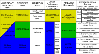
Click on thumbnail to enlarge the image.
Figure 1: 's Vraconnian (1868) and its location between d''s Albian and Cenomanian stages (1842-1847). D''s citation (1850) of Turrilites hugardianus among the species characteristic of the Albian stage, of Turrilites bergeri in the Albian and Cenomanian and of Ammonites renauxianus in the Cenomanian led to a certain amount of confusion in the historic definition of the Albian-Cenomanian boundary.
In fact, the three species are contemporaneous and coexist, in particular at the La Vraconne site, the type locality of 's 'Vraconnien' (1868). In terms of ammonites, the Vraconnian is equivalent to the Stoliczkaia dispar Zone auct., which in reality has three divisions, from bottom to top: the Mortoniceras (Mortoniceras) fallax IZ (Interval Zone), the M. (Subschloenbachia) perinflatum TRZ (Total Range Zone) and the Arrhaphoceras (Praeschloenbachia) briacensis IZ (the usage of the last-named zone is limited to northwestern Europe because of the provincialism of its faunas).
Note that the range of Stoliczkaia (Stoliczkaia) dispar (d') is restricted to the Mortoniceras (Subschloenbachia) perinflatum TRZ, that is to the middle Vraconnian. For this reason the incorporation of the Vraconnian as a Stoliczkaia dispar Zone auct. seems a little abusive.
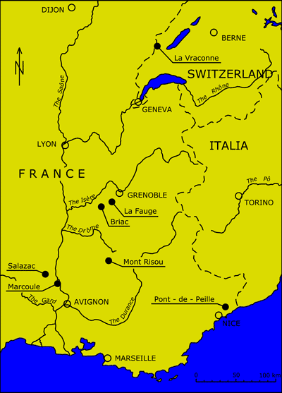
Click on thumbnail to enlarge the image.
Figure 2: Geographic location of localities in the Swiss Jura and southeastern France cited in the text.
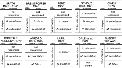
Click on thumbnail to enlarge the image.
Figure 3: Comparison of ammonite zonations for the Vraconnian of northwestern Europe (the only region of the world having been studied in detail) after 1923.
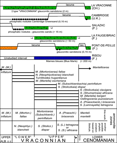
Click on thumbnail to enlarge the image.
Figure 4: Vertical distribution of some significant Vraconnian ammonites in the reference sections of northwestern Europe and, just below the zonation in current use, the proposal of an alternative zonation based on the evolution of the Stoliczkaiinae. Data for the several sections are taken from the following works: La Vraconne ( & , 1965; & , 1978), Cambridge ( & , 1965), Salazac (, 1994b), La Fauge-Briac (, 1936; , 1973), Pont-de-Peille ( & , 1988), Risou ( et alii, 1996). Note that the phosphatic nodules of the Cambridge Greensand, although having yielded numerous type species of ammonites, are in fact reworked in a glauconitic matrix of Cenomanian age (, 1973a). From another side, the ammonite collections there reveal a condensation of the M. (M.) fallax and M. (S.) perinflatum zones with an enormous predominance of species reworked from the "lower" Vraconnian, and a small proportion of species from the "upper" Vraconnian (, 1947). The lower boundary of the Cenomanian stage recommended at the time of the "Second International Symposium on Cretaceous Stage Boundaries" ( & , 1996) is taken at the first appearance of the planktonic foraminifer Rotalipora globotruncanoides (= R. brotzeni). As a consequence the Vraconnian-Cenomanian boundary is shifted slightly lower with respect to the previous divisions based on ammonites.
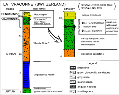
Click on thumbnail to enlarge the image.
Figure 5: The Vraconnian at the type locality, La Vraconne (Swiss Jura). The contraction of the succession (here the Vraconnian is but 2 m thick) explains in large measure the richness of the deposit in ammonites that have furnished several thousands of specimens distributed among 125 species.
The description of the material by & (1858-1864) is at the origin of the deposit's renown.
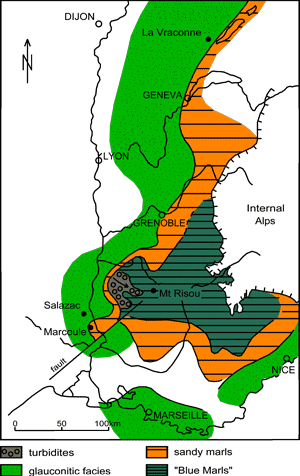
Click on thumbnail to enlarge the image.
Figure 6: The major domains of sedimentation of southeastern France during the Vraconnian after , 1984; , 1997, and , 1999. The central portion of the basin, in a pelagic facies, is the site of deposition of the "Marnes bleues" [Blue Marls] and constitutes the Vocontian trough. The shallow peripheral domains are glauconitic sands. Between the two are hemipelagic facies, mainly sandy marls. The sections studied at Salazac, Marcoule and Mont-Risou are distributed geographically in these three sedimentary domains.
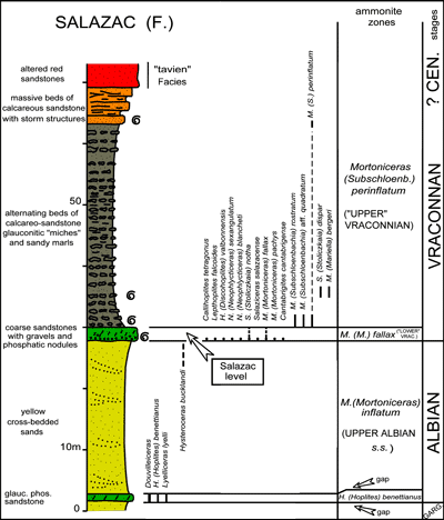
Click on thumbnail to enlarge the image.
Figure 7: The Vraconnian at Salazac (southeastern France). Here the Vraconnian starts with a transgression: coarse glauconitic sandstone with rounded gravels and phosphatic nodules that are rich in the ammonites of the Mortoniceras (M.) fallax Zone. This is the "niveau de Salazac auct.". Above is a thick series of sandy marls alternating with sandy, glauconitic "miches"* that is dated as the M. (Durnovarites) perinflatum Zone. The Vraconnian terminates with a regressive sequence with calcareous sandstones showing storm structures.
The entire succession lies in a 3rd order eustatic cycle. Note that the alternating beds of sandy, glauconitic miches are much finer and more numerous than is indicated in the lithologic column. This is due to a rough cyclicity which may have an orbital origin ( cycles, 1920) and involve the precession of the equinoxes (cycles of 20-22,000 years).
*miches: sandstone beds weathered to form recognizable large ovoid masses in a normally bedded succession (miches = rounded loaves).
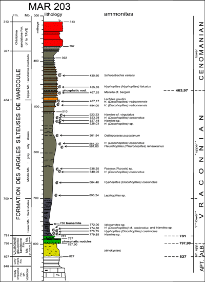
Click on thumbnail to enlarge the image.
Figure 8: Vertical distribution of the Vraconnian and Cenomanian ammonites collected from the cores of the ANDRA MAR 203 well at Marcoule in the Gard (Rhone valley). Using the outcrops at Salazac only 20 km away for comparison, the lower boundary of the Vraconnian is interpreted as being at 798 m at a phosphatic nodule level at the base of glauconitic sandstones and gravels, that is, at the bottom of the upper member of the Valbonne Formation. The Vraconnian-Cenomanian boundary is taken at 463.97 m, at the level of a second phosphatic nodule bed located in the upper member of the Silty Shales Formation of Marcoule, and is intercalated between the uppermost collected specimen of a Vraconnian ammonite (at 467.25 m) and the first Cenomanian ammonite (at 455.85 m). At the time of the "Second International Symposium on Cretaceous Stage Boundaries" in Brussels 1995 the lower boundary of the Cenomanian was defined as the appearance of Rotalipara globotruncanoides and in fact is probably a few meters lower. In the absence of planktonic foraminifera, the Vraconnian-Cenomanian boundary is taken here to be at the appearance of an ammonite association consisting of Mantelliceras, Shloenbachia, Hyphoplites (Hyphoplites), Neostlingoceras, ... As the two events are very close to each other, with the appearance of R. globotruncanoides slightly earlier, the degree of precision obtained is quite sufficient in this study. In all, 22 ammonites were collected in the Silty Shale Formation of Marcoule. The large proportion of Hoplitidae clearly attaches the Marcoule region to the Boreal realm during the Vraconnian, and in particular to the 's Hoplitinae faunal province (1973) which includes nearly all of northwestern Europe.
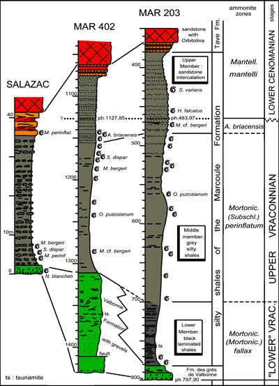
Click on thumbnail to enlarge the image.
Figure 9: Correlation of Marcoule wells MAR 203 and MAR 402 with the Salazac outcrop, 20 km to the northeast.
In the Marcoule MAR wells, in the absence of the ammonites characteristic of the lower Vraconnian, a correlation of the level at Salazac with Mortoniceras (M.) fallax and Neophlycticeras (N.) blancheti in granular glauconitic sandstones (at the base with a bed of hard phosphatic nodules of the Valbonne Formation) with the black laminated shales of the lower member of the Marcoule Formation is substantiated by the sedimentologic context (, 1999), by planktonic foraminifera of Vraconnian age (not high in the sequence in sample 775. 64-777.06 in MAR 203) and by the sharing of a tsunamite level in wells MAR 402 and MAR 203.
The most expanded portion of the succession in the wells is the middle member of the Marcoule silty shales. The majority of the ammonites collected from the well cores come from this unit. Their association permits the identification of the Mortoniceras (S.) perinflatum Zone.
Above it, the upper member with its sandstone interbeds ends at the Vraconnian-Cenomanian boundary. The lower third of this member delivered ammonites of the Arrhaphoceras (P.) briacensis Zone, while the upper two-thirds, above a phosphatic level at the base of the Cenomanian, has an association of the Mantelliceras mantelli Zone. The abundance of Vraconnian ammonites at Marcoule serves only to emphasize their usual great rarety in wells. But the main interest of the well sections is the considerable thickness of the sedimentary record: in well MAR 203, the one with the most expanded succession, the Vraconnian attains 334 m.
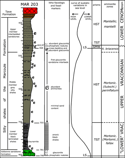
Click on thumbnail to enlarge the image.
Figure 10: Interpretation of sequence stratigraphy of the Vraconnian at Marcoule. The bottom level of glauconitic sandstone and gravels with a bed of phosphatic nodules in the lower part, the Valbonne Formation, and then the black laminated shales of the lower member of the Marcoule Formation are interpreted as a transgressive interval.
Above, the grey, silty shales with abundant ammonites that form the middle member of the Marcoule Formation represent a Highstand Systems Tract, The glauconitic, cross-bedded sandstone beds under the phosphatic level at the Vraconnian-Cenomanian boundary are the indicators of a shelf margin wedge.
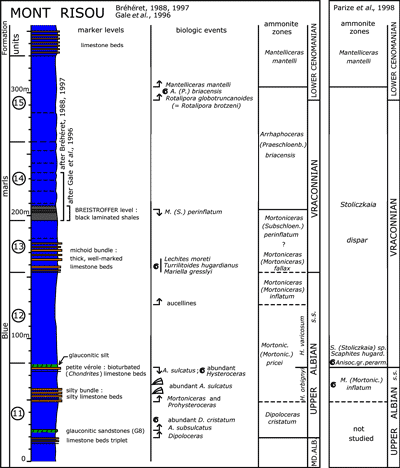
Click on thumbnail to enlarge the image.
Figure 11: The Upper Albian s.s. and the Vraconnian at Mont-Risou (Drôme).
This is the reference section accepted at the time of the "Second International Symposium on Cretaceous Stage Boundaries" held in Brussels in 1995 to define the base of the Cenomanian.
As at Salazac and Marcoule the Vraconnian is exceptionally thick. In addition the Mont-Risou section is the one where the upper Vraconnian Arrhaphoceras (Praeschloenbachia) briacensis ammonite Zone is, in the current state of knowledge, the thickest and best exposed in the world.
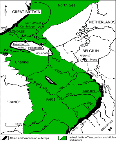
Click on thumbnail to enlarge the image.
Figure 12: Actual boundaries of Albian and Vraconnian sediments in the Anglo-Paris basin (in black and green) and the location of the localities cited in the text (after , 1992). Taking erosion into consideration, if the present contours correspond generally to the Albian and Vraconnian littoral, the basin is in the form of an area of sedimentation oriented NW-SE, linked in the northern part with the North Sea and southward communicating with the Alpine domain through the Burgundy passageway.
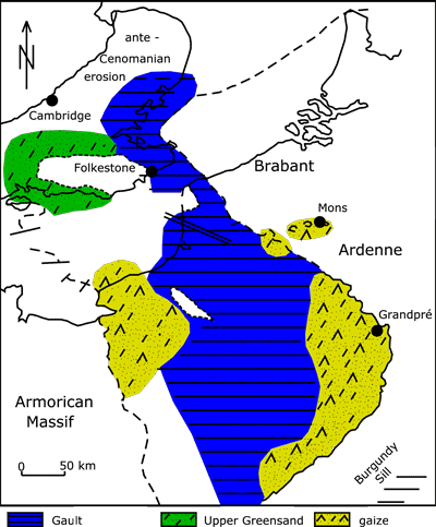
Click on thumbnail to enlarge the image.
Figure 13: Facies distribution in the Anglo-Paris basin (after , 1974; et alii, 1980; , 1984, for the French part of the basin, and , 1960; & , 1965, and & , 1982, for the British part).
An examination of the map shows three principal facies:
in a large central band of the basin, light grey marls in a Gault facies with a higher zone in the Artois, south of the Boulonnais;
in the western part of the Weald, glauconitic sands and sandstones more or less calcareous or argillaceous (Upper Greensand);
in Normandy, in the Mons basin and on the southeast border of the basin, silty, glauconitic marls, often consolidated, rich in sponge spicules with cherts (gaizes, "meules" of the Belgian Hainault).
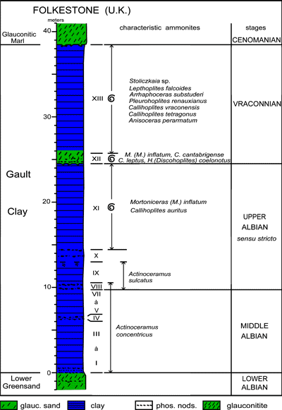
Click on thumbnail to enlarge the image.
Figure 14: Generalized lithology of the shales in a Gault facies at Folkestone (U.K.) as described by (1874) and (1976). Although this locality is in the northern part of the Anglo-Paris basin where sedimentation is reduced in comparison with the south half (, 1992), the thickness of the Vraconnian remains relatively important: 14.70 m. From another side, the presence of glauconite and reworked phosphatic nodules immediately above bored surface makes possible the interpretation of bed XII as a transgressive unit (IT). Beds XII and XIII together represent a eustatic cycle of the 3rd order (, 1992; , 2000).
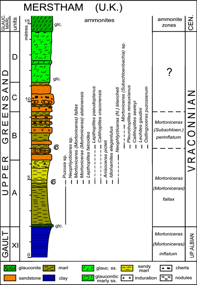
Click on thumbnail to enlarge the image.
Figure 15: Lithology and distribution of ammonites in the Upper Greensand (Vraconnian) of Merstham at the northern edge of the Wealden in southeastern England (after , 1976, 1996a). At the Gault Clay � Upper Greensand boundary, there is a glauconitic bed which can be correlated with bed XII at Folkestone. It is the base of the Vraconnian transgressive interval. The mass of the Upper Greensand may be correlated with bed XIII at Folkestone and consequently marks a clear lateral change in facies. Four lithologic units found regionally are superposed. From bottom to top:
Unit A (4.25 m: light grey marls, becoming sillty upward;
Unit B (2.80 m): alternations of pluri-decimetric sandstones and marly levels;
Unit C (1.90 m): massive, more or less indurated sandstones
Unit D (3.35 m): glauconitic sandstone
Finally, in contrast to the shale facies of bed XII at Folkestone that has a poor ammonite fauna, the Upper Greensand has a relatively rich and diversified fauna, with in Unit A and the first sandstone bed of Unit B, an association of the M. (M.) fallax Zone and in the remainder of Unit B an association of the M. (S.) perinflatum Zone. On the other hand, units C and D for the moment have not furnished ammonites and their zonal attribution remains imprecise.
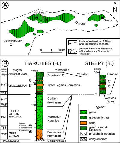
Click on thumbnail to enlarge the image.
Figures 16: The Albian and Vraconnian in the Mons basin (Belgian Hainault) Geographic distribution and isopachs of the Albian and Vraconnian meules after (1939, 1965). The lithology of Well n° 1 of Harchies is after (1939); that of the excavation for the boat lift at Strépy-Thieu is after (unpublished).
16 A. The Mons basin forms a digitations some forty kilometers long by ten wide at the northeast corner of the Anglo-Parisian basin. The "Albian and Vraconnian meules" (millstones) are preserved in vast depressions ("cuves") on the Paleozoic surface. According to (1972) the "cuves" formed as the result of vertical subsidence linked to the dissolution of evaporites (collapse) in the Paleozoic substratum, and more precisely in the middle Devonian.
16 B. Harchies Well n° 1 is located in the Pommeroeul "cuve", the deepest one in the Mons basin. The Albian and Vraconnian "meules" were penetrated between the depths of 82,0 m and 226,70 m, a thickness of 144.7 m in which (1936) defined four formations, from top to bottom: Bracquegnies Fm., Catillon Fm., Harchies Fm., and Pommeroeul Fm. All the formations begin at the base with conglomerates, which, in accordance with the concepts of sequence stratigraphy ( et alii, 1987) are interpreted as Transgressive Systems Tracts (TST) that may or may not be followed by Highstand Systems Tracts (HST). And although the Pommeroeul, Harchies and Catillon formations are preserved only in the "cuve" where Harchies n° 1 is located, the lateral extent of the Bracquegnies Formation covers almost all of the Mons basin and reaches Strépy to the East.
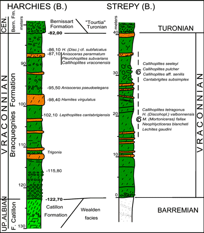
Click on thumbnail to enlarge the image.
Figure 17: Vertical range of Vraconnian ammonites collected from the Bracquegnies Formation of Harchies Well n° 1 and from the excavations required for the foundations of the Strépy boat lift (Determinations by in , 1942 for the Harchies well; , in this work for the Harchies well). The ammonite fauna is rich and diversified, with a large percentage of Hoplitidae (Lepthoplites, Callihoplites, Pleurohoplites, Hyphoplites, Discohoplites) that shows the Mons basin to be in the northern European province of the Boreal realm. On another side, the Strépy yield of an association including Neophlycticeras (Neophlycticeras) blancheti, Mortoniceras (Mortoniceras) fallax and Cantabrigites subsimple permits a determination of the age of the Bracquegnies Formation. It is attributed to the M. (M.) fallax ammonite Zone, that is to say to the "lower" Vraconnian, a date that could not be established until now.
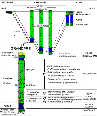
Click on thumbnail to enlarge the image.
Figure 18: The Vouziers Gaize: geometry of the sedimentary succession along a north-south section and its ammonite fauna. The Vouziers Gaize is a thick formation that is developed for some sixty kilometers along the eastern edge of the Anglo-Paris basin. At Grandpré it is 80 m. thick and attains 110 m at the Islettes, 20 km farther south. The lithologic succession is still poorly known. According to (1878) the Vouziers Gaize has a bed of phosphate nodules called Talma phosphatic nodule bed 10 m above the base of the formation, then an interval rich in "coquins" (nodules) of gaize, and then the main body of the gaize itself.
The ammonites of the collection located in the Museum at Lille have been revised by (1985). The specimens from the Talma phosphatic level and the "coquins" of gaize date the Late Albian. But most of the material comes from the "upper gaize" and represents a rich association of Vraconnian age, in particular from the Mortoniceras (Subschloenbachia) perinflatum Zone. It is probable, however, that the whole Vraconnian is represented in the Vouziers gaize which merits detailed study in the future.
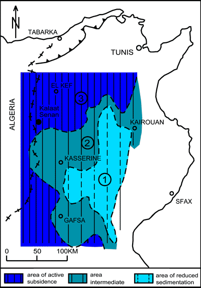
Click on thumbnail to enlarge the image.
Figure 19: Distribution of areas of subsidence in the Aptian-Albian (including the Vraconnian) in central Tunisia, after (1956).
Three geographic areas, each with a different sedimentary record, can be traced from southeast to northwest:
an area (or high zone) of reduced sedimentation (platform facies) east of Kasserine;
an intermediate, moderately subsident area. With marls and limestones alternating;
an area of active subsidence centered on El Kef, which to the SW passes the Algerian frontier (Tunisian trough).
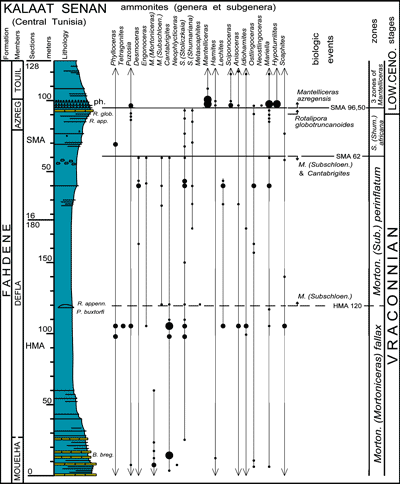
Click on thumbnail to enlarge the image.
Figure 20: Lithology, micropaleontological markers (planktonic foraminifera) and vertical range of ammonite genera of the Vraconnian in the vicinity of Kalaat Senan in central Tunisia (after et alii, 2007)
Two sections, in succession, HMA and SMA, are correlated faunally and in 260 m cover almost all of the Vraconnian, except perhaps near its base, the contact with the Upper Albian s.s.. The lithologic sequence consists of three members, from bottom to top according to et alii (1994):
the Mouella Member: beds of black, commonly laminated limestone;
the Defla Member: marls;
the Azreg Member: limestones, marls and phosphatic levels
The vertical range of the ammonites show that on the southern margin of the Tethys in North Africa the Vraconnian has three ammonites zones as it does in Europe. The only difference is that it is impossible to use Arrhaphoceras (Praeschloenbachia) briacensis as the index fossil of the highest zone because the geographic distribution of the species is restricted to 's (1973) Hoplitinae faunal province that is the equivalent to 's (1973) Northwestern Europe faunal province. An alternative might be the usage of Stoliczkaia (Shumarinaia) africana already present in the preceding M. (S.) perinflatum Zone, but more abundant in the interval concerned.
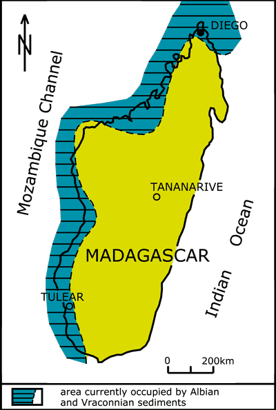
Click on thumbnail to enlarge the image.
Figure 21: Paleogeographic sketch of Madagascar during the Vraconnian, after (1975).
The Albian and Vraconnian are preserved in a series of coastal basins along the west side of the island. A paleogeographic reconstruction shows the shoreline passing the existing shoreline some 50 to 100 km inland along the Mozambique Channel. The Diégo well is at the north end of Madagascar.
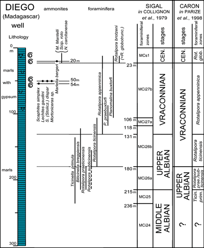
Click on thumbnail to enlarge the image.
Figure 22: The Upper Albian and Vraconnian in the Diégo well (Madagascar). Lithology from (1972); distribution of ammonites and foraminifera after et alii (1979).
If the Vraconnian is defined using foraminifera as being the interval between the appearance of Rotalipora appenninica and that of Rotalipora globotruncanoides (= R. brotzeni), the position adopted by (1977, 1987) and by the European working group on planktonic foraminifera ( & , 1979), 108 m of the Vraconnian stage were drilled through in the Diégo well, between the depths of 23 and 131 m. As in central Tunisia, the Vraconnian is very thick in the Diégo well.
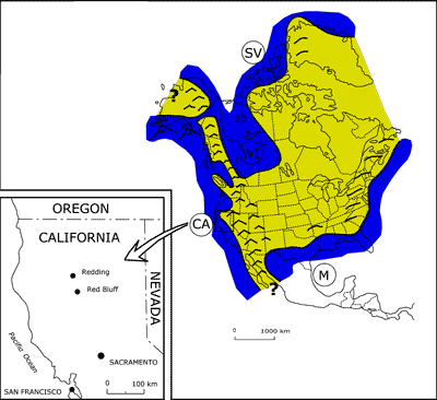
Click on thumbnail to enlarge the image.
Figure 23: Paleogeographic reconstruction of North America during the Vraconnian (after & , 1975) and the geographic location in northern California of the section studied.
There is no connection in outcrop or in wells between the Vraconnian formations in the Gulf of Mexico and those of the Western Interior that was occupied by an interior sea called the "Mowry Sea". For that reason the idea of a brief or permanent connection between them, not considered by & (1975) but suggested by (1996a), is completely speculative.
Along the western coast of the United States the Cretaceous sedimentary basins are sited on the edge of the North American plate in a very subsident belt. The best Vraconnian sections are in northern California, west of Redding and Red Bluff, some 200 km NW of the state capital, Sacramento. The section studied best at this time is named Dry Creek, some 30 km west of Red Bluff.
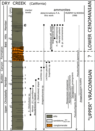
Click on thumbnail to enlarge the image.
Figure 24: The boundary between Vraconnian and Cenomanian strata in the Dry Creek section (northern California). The lithologic survey shown in the figure is the author's, made with the collaboration of F. (Mons, Belgium). The numbering of the sandstone beds is reproduced from & (1996). The ammonite distribution uses the author's determinations and the vertical ranges published by & (1996).
The Dry Creek section is 270 m thick and cuts across a part of two members of the Budden Canyon Formation, from bottom to top:
the upper part of the Upper Chickabally Member, consisting of silts interbedded with pluri-decimetric sandstones;
the lower part of the Bald Hills Member. It is bounded at the bottom by a double conglomerate and above it are two levels of thin beds of channeled sandstones.
The table of ammonite distribution shows that the first species dating the Cenomanian: Mantelliceras aff. saxbii () was collected from the conglomeratic levels at the base of the Bald Hills Member.
The association identified below, in the Upper Chickabally Member, contains a majority of ammonites of which the geographic distribution is confined to the North Pacific Faunal Province: Beudanticeras haydeni (), Mesopuzosia colusaense (), Marshallites cumshewensis (), Tetragonites rectangularis , Pseudouhligella dawsoni (), P. japonicum () and Anagaudryceras buddha (). These ammonites are interesting from a paleobiogeographic standpoint, but have little biostratigraphic value. On the other hand, the presence of Stoliczkaia (S.) dispar (d'), Mortoniceras (S.) perinflatum () and Lechites gaudini ( et ) permit the recognition of the "upper" Vraconnian. Even if but the upper part of the Vraconnian crops out at Dry Creek, the section shows a very important record of sedimentation.
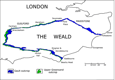
Click on thumbnail to enlarge the image.
Figure 25: Map of the Gault and the Upper Greensand of the Weald (U.K.) after (1976).
In the field, the stages have discrete lithologies that make them mappable. 's studies (1976, 1996a) showed that the Upper Greensand is isochronous across the Weald of southeastern England and dated it Vraconnian. Here the Upper Greensand is from 15 to 20 m thick. The map of the formation shown in Figure 25 after (1976) makes it possible to visualize perfectly the contours of the Vraconnian from Eastbourne in the south to Sevenoaks in the North, even on a small scale map. This possibility of mapping is a positive element for considering the Vraconnian as a discrete, full-fledged stage (NB: Between Sevenoaks and Folkestone the Vraconnian is in a Gault facies and did not map it. It involves beds XII and XIII of Folkestone.
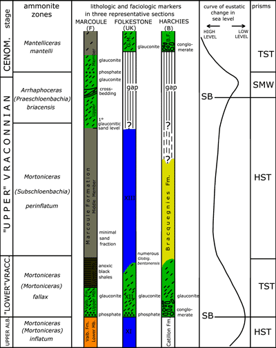
Click on thumbnail to enlarge the image.
Figure 26: Sequential interpretation of the Vraconnian.
In the three representative sections illustrated, the Vraconnian begins with glauconitic levels bounded at their base by a bed of phosphatic nodules or by a conglomerate. This is a Transgressive Systems Tract (TST). Above, the Highstand Systems Tract (HST) encloses an abundant macrofauna, most often rich in ammonites.
At Marcoule the upper portion of this highstand wedge contains the first glauconitic sandstone levels that announce the beginning of a regressive tendency. On the platforms or on intra-cratonic basins like the Anglo-Paris basin, the marine low levels do not deposit sediments and are represented by important gaps. That is the reason why a hiatus separates the Vraconnian and Cenomanian formations at Folkestone and Harchies. Such is not the case at Marcoule where the stressing of the regressive tendency causes the deposition of a shelf margin wedge (SMST) marked by the occurrence of coarse glauconitite, of beds with oblique bedding and of dynamic structures with much bioturbation. All in all, the curve of the eustatic variations of the marine level show that the Vraconnian is completely within a 3rd order cycle.
Click on thumbnail to enlarge the image.
Figure 27: Attempt at a paleogeographic reconstruction of the world during the Vraconnian. Position of the continents is that established by & (1977) as modified by et alii (1994). Paleogeographic contours were drawn using information published by & (1975), et alii (1994) and (1996b).
The proposed reconstruction evinces no spectacular changes from Albian paleogeography but rather shows a progressive change in shorelines in connection with the great Cretaceous transgression. Note that in North America there does not seem yet to have been relations between the interior sea (Mowry Sea) and the Gulf of Mexico. On the other hand, communications between the North and South Atlantic were enlarged. Thereby, ammonite faunas in Texas and Mexico have close affinities with those of Brazil, Nigeria, Angola and South Africa.
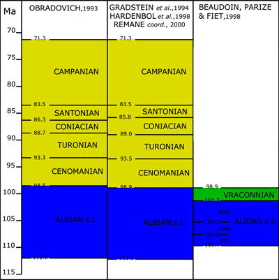
Click on thumbnail to enlarge the image.
Figure 28: Radiometric datings for the boundaries of the Albian to Campanian stages by (1993) and by et alii (1994). A comparison of these time scales shows a great similarity in their results, in particular that of the duration of the Albian s.l. stage which is between 13.3 and 13.5 Ma, that makes it the longest in the Cretaceous System.
In the right-hand column, the ages indicated by et alii (1998) are extrapolated by a cyclostratigraphic analysis of the "Fucoid Marls" of the Marches-Umbrian basin in central Italy, starting with the lower boundary of the Cenomanian placed at 98.9 Ma.
The cyclostratigraphic study of the "Fucoid Marls" and of the Marcoule Formation in southeastern France assigns the Vraconnian a length of 2.4 ± 0.2 Ma that sets the base of the Vraconnian at 101.3 Ma. If the Vraconnian stage were retained in the international geological calendar the duration of the Albian s.s. would be reduced to 8.4 Ma.
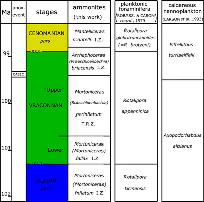
Click on thumbnail to enlarge the image.
Figure 29: The Vraconnian stage in 2008. Comparison of the radiometric scale with zonations based on ammonites, planktonic foraminifera and calcareous nannoplankton. The lower boundary of the Vraconnian dated at 101.3 ± 0.2 Ma is taken at the first appearance of the ammonite Mortoniceras (Mortoniceras) fallax (). The upper boundary, that is the base of the Cenomanian, dated at 98.9 Ma coincides with the first appearance of the planktonic foraminifer Rotalipora globotruncanoides (= R. brotzeni (). Note: because of a slight offset in the limits of the ammonite and foraminiferal zones, the uppermost part of the Arrhaphoceras (Praeschloenbachia) briacensis ammonite Zone extends into the Lower Cenomanian.
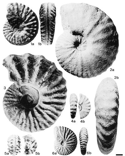
Click on thumbnail to enlarge the image. [Scale bar = 1 cm]
Plate 1: Zonal index ammonites of the Vraconnian.
Fig. 1.- Mortoniceras (Mortoniceras) fallax (); holotype [with three tubercles per side, where the lateral tubercle is always prominent], from the Cambridge Greensand (U.K.) Sedgwick Museum collection, n° SMC B56, "lower" Vraconnian, of the M. (M.) fallax IZ (copied from , 1994a, Pl. 3, fig. 1).
Fig. 2.- Stoliczkaia (Stoliczkaia) dispar [with large straight ribs, flattened at mid-flank, lack of the siphonal tubercle, and with a compressed axial section], from la Fauge, Isère (France), Sorbonne collection, Paris, n° A860, "upper" Vraconnian, (copied from & , 1994, p. 571, Fig. 14.n-c). The Vraconnian is often referred to as the Stoliczkaia dispar Zone auct.. This presumption of equivalence is in fact abusive because the vertical range of the species is limited to the Mortoniceras (Subschloenbachia) perinflatum TRZ, that is to the base of the "upper" Vraconnian.
Fig. 3.- Mortoniceras (Subschloenbachia) perinflatum (); holotype [with a thick whorl section and 4 tubercles per rib], from La Vraconne in the Vaud canton (Switzerland), Mus. Hist. Nat. Genève collection (copied from & , 1968, Pl. 14, fig. 4).
Fig. 4.- Stoliczkaia (Shumarinaia) africana (); paralectotype [with a compressed whorl section and strong ribs bearing well developed ventro-lateral tubercles on the phragmocone], from Jebel Zrissa, (Tunisia), collection, housed in the Sorbonne, Paris, "upper" Vraconnian (copied from & , 1994, p. 553, Fig. 3.v-w). S. (Shumarinaia) africana occurs in the M. (S.) perinflatum TRZ, but is especially common on the northern margin of the Tethys in the interval equivalent to the A. (P.) briacensis IZ of the northern European province of the Boreal realm. In the future, this taxon could constitute an alternative solution to index the upper division of the Vraconnian in the Tethyan realm.
Fig. 5.- Arrhaphoceras (Praeschloenbachia) briacensis () [with a siphonal keel as in Schloenbachia, but like A. (Arrhaphoceras) the shell has no lateral tubercles], from Pont-de-Peille in the Alpes-Maritimes (France), collection, n° 28262, "upper" Vraconnian, P. (A.) briacensis IZ (copied from & , 1988, Pl. 1, fig. 3.b-c).
Fig. 6.- Neophlycticeras (Neophlycticeras) blancheti ( et ); lectotype of Ammonites rhamnonotus [with tectiform venter, provided with a row of siphonal tubercles even on the body chamber], from the Cambridge Greensand (U.K.), Sedgwick Museum collection, n° SMC B 45, "lower" Vraconnian, M. (M.) fallax IZ (copied from & , 1994, p. 556, Fig. 6.e-f). In choosing the evolution of the Stoliczkaiinae for a phyletic zonation of the Vraconnian, N. (N.) blancheti could replace Mortoniceras (M.) fallax as the index for the "lower" Vraconnian.
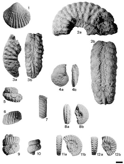
Click on thumbnail to enlarge the image. [Scale bar = 1 cm]
Plate 2: The ammonites and pectens of the "lower" Vraconnian: Mortoniceras (Mortoniceras) fallax IZ of Salazac (Gard, France). The assemblage comes from the "principal level" of Salazac.
Fig. 1.- Merklinia aspera (), coll. FA n° 1201. In the XIXth century, the species was considered as being confined to the lower part of the Cenomanian, from which arose the abusive equivalence by (1868) of the Pecten asper Zone with the upper part of the Vraconnian. In fact, M. aspera is now known to range up from the lower part of the Vraconnian.
Figs. 2-3.- Mortoniceras (Mortoniceras) fallax () [with 3 tubercles per rib, the lateral tubercle always the most prominent], coll. FA n° 1202 (Fig. 2), n° 1203 (Fig. 3).
Fig. 4.- Lepthoplites cantabrigiensis [compressed section, with sinuous ribs that arise in groups of 2 or 3 from umbilical bulla and terminate in tiny crenulations on the ventro-lateral edge], coll. FA n° 1204.
Fig. 5.- Mariella (Mariella) cantabrigiensis () [oblique ribs with 3 rows of rather prominent rounded tubercles], coll. FA n° 1205.
Fig. 6.- Mariella (Mariella) nobilis () [with 26-28 flexuous ribs per whorl, each with three rows of small tubercles], coll. FA n° 1206.
Fig. 7.- Lechites gaudini ( et ) [oval section and shell ornamented with simple, oblique ribs, narrower than the intercostal spaces], coll. FA n° 1207.
Fig. 8.- Hyphoplites (Discohoplites) valbonnensis ( et ) [thick section and widely-spaced rather robust falciform ribs], coll. FA n° 1208.
Figs. 9-10.- Turrilitoides hugardianus (d') [rather heavy oblique, flexuous ribs, 24 to 30 per whorl], coll. FA n° 1209 (Fig. 9), n° 1210 (Fig. 10).
Fig. 11.- Cantabrigites picteti [with parallel sides and straight ribs with an umbilical tubercle and a well-marked ventro-lateral tubercle], coll. FA n° 1211.
Fig. 12.- Mortoniceras (Mortoniceras) nanum [micromorph of Mortoniceras with three tubercles per rib. The weakly developed lateral tubercle appear only on the last whorl], coll. FA n° 1212.
All the specimens are deposited in the collection in Calais (France).
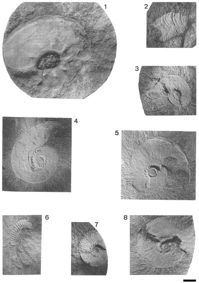
Click on thumbnail to enlarge the image. [Scale bar = 1 cm]
Plate 3: The ammonites of the "upper" Vraconnian: Mortoniceras (Subschloenbachia) perinflatum TRZ and of the Lower Cenomanian Mantelliceras mantelli IZ in well 203 at Marcoule (Gard, France).
Fig. 1.- Schloenbachia varians () [the keeled shell has well developed ventro-lateral tubercles on the lower third of the side], 430.80 m, Lower Cenomanian.
Fig. 2.- Hyphoplites (Hyphoplites) falcatus () [with very clearly falciform, fine and flattened ribs], 455.85 m, Lower Cenomanian.
Figs. 3-5, 8.- Hyphoplites (Discohoplites) coelonotus () [with very fine falciform ribs without ventro-lateral tubercles]. 3: 523.38 m; 4: 776.75 m; 5: 664.48 m; 8: 640.05 m, Vraconnian. All four.
Fig. 6.- Hamites cf. virgulatus [ribs straight, which are attenuated in the dorsal region], 523.23 m, Vraconnian.
Fig. 7.- Pleurohoplites (Pleurohoplites) renauxianus (d') [with flexuous, not lautiform ribs], 581.90 m, Vraconnian.
All of these ammonites are deposited in the core store of ANDRA at Les Ullis (France).
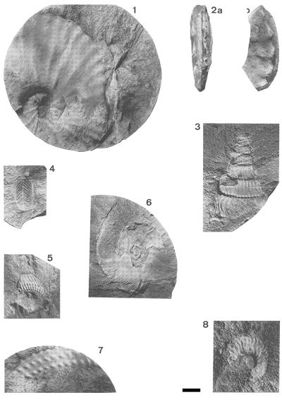
Click on thumbnail to enlarge the image. [Scale bar = 1 cm]
Plate 4: The ammonites of the "upper" Vraconnian: Mortoniceras (Subschloenbachia) perinflatum TRZ and Arrhaphoceras (Praeschloenbachia) briacensis IZ in wells MAR 203 and MAR 402 at Marcoule (Gard, France).
Fig. 1.- Stoliczkaia (Stoliczkaia) dispar (d') [large straight ribs, flattened at mid-flank, 22 ribs in a half whorl], MAR 402, 1174.05 m "upper" Vraconnian.
Fig. 2.- Arrhaphoceras (Praeschloenbachia) briacensis (), an example of a transitional form to Schloenbachia varians () [the absence of lateral tubercles is a characteristic of Arrhaphoceras, but the sketchy keel, perhaps accentuated by the crushing of the shell, shows affinities with Schloenbachia], MAR 402, 1143.63 m, "upper" Vraconnian, A. (P.) briacensis IZ.
Figs. 3, 5.- Ostlingoceras puzosianum (d') [ribs straight, 3 rows of small tubercles at the base, slightly more numerous than those on the ribs], 3: MAR 203 561.54 m, 5: MAR 402, 1241.75 m, "upper" Vraconnian.
Fig. 4.- Hyphoplites (Discohoplites) cf. coelonotus () [fine ribs, without ventro-lateral tubercles], MAR 402, 1146.55 m, Vraconnian.
Fig. 6.- Puzosia (Puzosia) sp., MAR 203, 636.25 m, Albian to Turonian.
Fig. 7.- Mariella (Mariella) cf. bergeri () [four rows of tubercles all with the same number NB: the lowest row is not unblocked on the impression illustrated], MAR 402, 1186.05 m, "upper" Vraconnian.
Fig. 8.- Hyphoplites (Discohoplites) valbonnensis ( et ) [thick section and ribs quite robust and widely spaced], MAR 203, 494 m, Vraconnian.
All of these ammonites are deposited in the core store of ANDRA at Les Ullis (France).
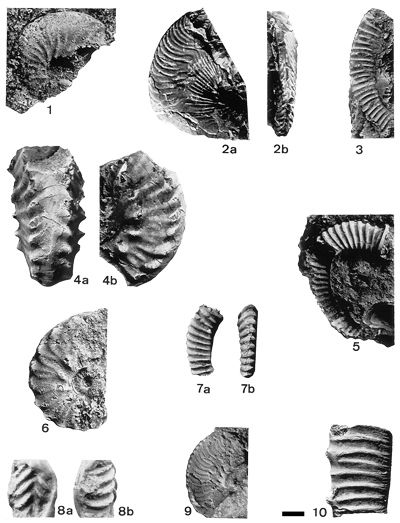
Click on thumbnail to enlarge the image. [Scale bar = 1 cm]
Plate 5: Cenomanian, Vraconnian and Albian ammonites from Harchies well n° 1 in the Mons basin (B).
Fig. 1.- Schloenbachia varians () [the keeled shell has ventro-lateral tubercles on the inner third of the side], n° HCH3 in the Bernissart Formation, 64.50 m, Lower Cenomanian.
Fig. 2.- Hyphoplites (Discohoplites) subfalcatus () [with fine falciform ribs and a sulcate venter], n° HCH6, Bracquegnies Formation, 86.10 m, Vraconnian.
Fig. 3.- Idiohamites sp., n° HCH2, Bracquegnies Formation, 87.1 m, Vraconnian.
Fig. 4.- Callihoplites vraconensis ( et ) [thick shells, a large ventral region, ribs simple, bifurcate or lautiform], n° HCH8 from the Bracquegnies Formation, 87.10 m, Vraconnian.
Figs. 5, 7.- Hamites virgulatus [shell with curvilinear coiling and straight, raised ribs], 5: n° HCH4, Bracquegnies Formation, 98.40 m; 7: n° HCH1, Bracquegnies Formation, 8.10 m, Vraconnian.
Fig. 6.- Pleurohoplites (Pleurohoplites) subvarians [shell compressed and ribs irregularly sigmoid], n° HCH7, Bracquegnies Formation, 87.10 m, Vraconnian.
Fig. 8.- Hoplites (Hoplites) dentatus (J. ) [alternating ribs and a large siphonal region], n° HCH0 from the Pommeroeul Formation, 204.10 m, Middle Albian.
Fig. 9.- Lepthoplites cantabrigiensis [compressed shell with fine falciform ribs starting in bundles of 2 or 3 from umbilical tubercles and ending with a crenulation on the ventro-lateral edge], n° HCH5, Bracquegnies Formation, 102.10 m, Vraconnian.
Fig. 10.- Anisoceras pseudoelegans ( et ) [ribs fine, some tied to ventral tubercles, the others (generally 1 or 2) intercalated], n° HCH9, Bracquegnies Formation, 95.50 m, Vraconnian.
All the ammonites from the Harchies n° 1 well are deposited in the geology collections of the Polytechnic Faculty at Mons (Belgium).
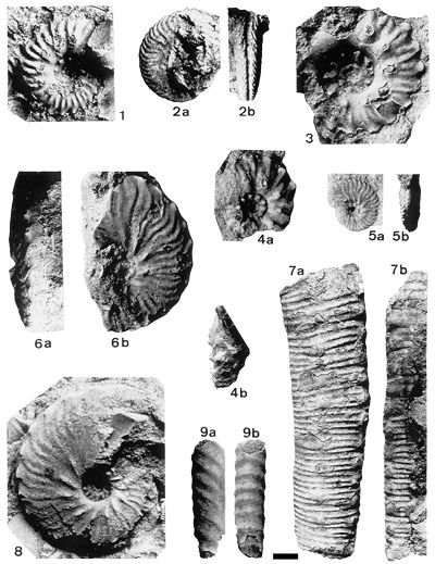
Click on thumbnail to enlarge the image. [Scale bar = 1 cm]
Plate 6: Ammonites from the "lower" Vraconnian, Mortoniceras (Mortoniceras) fallax IZ from the boat-lift at Strépy-Thieu (Belgium).
Figs. 1, 3.- Callihoplites tetragonus () [thick shell and lautiform ribs], 1; n° ST2 from the 15 to 25 m; 3: n° ST1 from the same interval, Bracquegnies Formation.
Figs. 2, 5.- Hyphoplites (Discohoplites) valbonnensis ( et ) [whorl section thick and robust well-separated falciform ribs], 2: n° ST3 from the 15 to 25 m interval, 5: n° ST10 from the excavation, Bracquegnies Formation.
Fig. 4.- Callihoplites seeleyi () [subhexagonal whorl section, ribs more or less zig-zag and with prominent ventral tubercles], n° ST 11 from the 25 to 35 m interval, Bracquegnies Formation.
Fig. 6.- Callihoplites pulcher [compressed whorl section, ventral region flattened, and lautiform and sigmoidal ribs], n° ST 13 from the 25 to 35 m interval, Bracquegnies Formation.
Fig. 7.- Anisoceras pseudoelegans et [fine ribs], n° ST 16 from the 15 to 25 m interval, Bracquegnies Formation.
Fig. 8.- Callihoplites aff. senilis [compressed section and sides almost parallel, lautiform and sigmoidal ribs becoming more and more attenuated on the last whorl of the spire], n° ST 12 from the 25 to 35 m interval, Bracquegnies Formation.
Fig. 9.- Lechites gaudini ( et ) [oval section and simple inclined ribs, narrower than the intercostal spaces], n° ST 15 from the 15 to 25 m interval, Bracquegnies Formation.
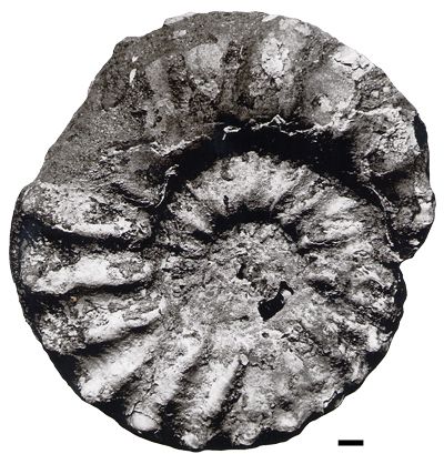
Click on thumbnail to enlarge the image. [Scale bar = 1 cm]
Plate 7: Ammonites from the "lower" Vraconnian, Mortoniceras (Mortoniceras) fallax IZ from the boat-lift at Strépy-Thieu (Belgium).
Mortoniceras (Mortoniceras) fallax () [with three tubercles per rib, and the lateral tubercle always prominent], n° ST 17 from the 15 to 25 m interval, Bracquegnies Formation.
 |
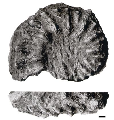 |
Click on thumbnail to enlarge the image. [Scale bar = 1 cm]
Plate 8: Ammonites from the "lower" Vraconnian Mortoniceras (Mortoniceras) fallax IZ from the boat-lift at Strépy-Thieu (Belgium).
Mortoniceras (Mortoniceras) aff. fallax () [3 tubercles per rib, with the lateral tubercle always more prominent], n° ST 18 from the excavation, Bracquegnies Formation
The holotype of M. (M.) fallax from the Cambridge Greensand (U.K.), illustrated in Pl. 1, fig. 1 is a phragmocone 68 mm in diameter with flat, subparallel sides and lateral tubercles sited half-way up the sides. (1994a, Pl. 3, fig. 2) figured an adult individual 125 mm in diameter from Salazac (F) of which the inner whorls are identical to those of the holotype thus permitting the evolution of ornamentation on the outer whorls to be followed. The ribs, at the origin alternating long and short, all become primary, while at the same time the lateral tubercles migrate slightly outward and the ventro-lateral tubercles become more prominent.
The specimens from Strépy (B) photographed here in plates 7 and 8 are large adults (respective diameters 185 mm and 158 mm). Specimen ST 17 illustrated on Pl. 7 is very like the one from Salazac with only long ribs on the last whorl and a tendency for the migration of the lateral tubercle. The specimen ST 18 figured here retains an alternation of primary and secondary ribs on the final whorl of the coiling and has sides that are more convergent. That is the reason why it is determined simply as M. (M.) aff. fallax ().
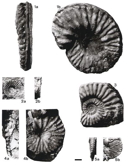
Click on thumbnail to enlarge the image. [Scale bar = 1 cm]
Plate 9: The ammonites of the "lower" Vraconnian from the Mortoniceras (Mortoniceras) fallax IZ found in the excavation for the boat-lift at Strépy Thieu (Belgium).
Fig. 1.- Mortoniceras (Mortoniceras) pachys () [three tubercles per rib with the lateral tubercle always the more prominent, fine and closely spaced ribs], n° ST 7 from the 15 to 25 m interval, Bracquegnies Formation.
Fig. 2.- Cantabrigites subsimplex () [ventro-lateral tubercles very distinct and sinuous ribs], n° ST 9 from the 15 to 25 m interval, Bracquegnies Formation.
Fig. 3.- Mortoniceras (Mortoniceras) sp. [the specimen shows affinities to M. (M.) fallax but with an attenuation of the lateral tubercle on the final whorl of the spire], n° ST 6 from the 15 to 25 m interval, Bracquegnies Formation.
Figs. 4-5.- Neophlycticeras (Neophlycticeras) blancheti ( et ) [ventral region tectiform, provided with a row of siphonal tubercles, well-marked even on the living chamber], 4: n° ST 5, 5: n° ST8, both from the 15 to 25 m interval, Bracquegnies Formation.