◄ Carnets Geol. 20 (1) ►
![]()
Outline:
[1. Introduction]
[2. Location of the section, material and method]
[3. Regional geological context]
[4. Remarks on lithostratigraphy and sedimentology]
[5. Remarks on microbiostratigraphy]
[6. Remarks on biomagnetostratigraphy]
[7. Conclusions]
[Bibliographic references] and ...
[Plates]
Dépt. STU, Fac. Sci. Tech., UBO, 6 avenue Le Gorgeu, CS 93837, F-29238 Brest (France)
6D avenue Général de Gaulle, F-05200 Briançon (France)
Department of Geology, Moulay Ismail University, Meknes (Morocco)
Published online in final form (pdf) on February 22, 2020
DOI 10.4267/2042/70714
![]()
[Editor: Michel Moullade; language editor:
Phil Salvador; technical editor: Bruno Granier]
![]()
The Tré Maroua site in SE France was recently selected by the Berriasian Working Group (BWG) of the International Subcommission on Cretaceous Stratigraphy (ISCS) as the candidate locality for the reference section of the Berriasian Global Boundary Stratotype Point (GSSP). However, on the basis of our preliminary investigation at this site and also from field observations over a larger area, this candidate section is paleogeographically located on a deep-water slope riddled with successive erosional surfaces, stratigraphic hiatuses and breccias. It does not meet at least four of the five "geological requirements for a GSSP". Accordingly, in our opinion, its candidacy must be definitely precluded.
Jurassic;
Cretaceous;
Tithonian;
Berriasian;
GSSP;
France;
sedimentology;
calpionellids
Granier B., Ferry S. & Benzaggagh M. (2020).- A critical look at Tré Maroua (Le Saix, Hautes-Alpes, France), the Berriasian GSSP candidate section.- Carnets Geol., Madrid, vol. 20, no. 1, p. 1-17.
Un regard critique sur Tré Maroua (Le Saix, Hautes-Alpes, France), la coupe candidate pour le PSM du Berriasien.- Le site de Tré Maroua en SE France a récemment été sélectionné par le Groupe de Travail Berriasien de la Sous-Commission Internationale de Stratigraphie du Crétacé comme la localité candidate pour la coupe de référence du Point Stratotypique Mondial (PSM) du Berriasien. Cependant, sur la base de nos recherches préliminaires effectuées sur ce site et dans les environs, il apparaît que cette coupe est paléogéographiquement située sur un paléotalus profond comportant des surfaces d'érosion emboîtées, des hiatus stratigraphiques importants et des brèches de resédimentation. Elle ne répond pas à au moins quatre des cinq "exigences géologiques pour un PSM". Par conséquent, à notre avis, sa candidature devrait être définitivement écartée.
Jurassique ;
Crétacé ;
Tithonien ;
Berriasien ;
Point Stratotypique Mondial (PSM) ;
France ;
sédimentologie ;
calpionelles
At the latest meeting of the Berriasian Working Group (BWG) of the International Subcommission on Cretaceous Stratigraphy (ISCS) in Bratislava (June 23th, 2019) and later again at STRATI2019 (July 4th, 2019), it was announced that the French site of Tré Maroua (Le Saix, Hautes-Alpes) received 80 % of the votes in the group as the Berriasian GSSP candidate section whereas the Italian site of Fiume Bosso (Cagli, Province of Pesaro and Urbino) received only 20%. Although it is not clear how this single French site was pulled out of the "plexus of sites (Le Chouet, Font de St Bertrand, Haute Beaume, Charens & Tré Maroua)" (Wimbledon et al., 2019), this result came as the culmination of extensive investigations over a period of some twelve years (i.e., three times four years for the ISCS mandate, starting with a first meeting in Bristol on July 8th, 2007) in order to identify a primary marker and secondary markers, then a GSSP site for the Berriasian stage boundary (Wimbledon et al., 2019, 2020). During the same period, more than 60 sites were evaluated worldwide by the BWG members. The final screening process led to discarding most of them except for the one site in Italy, i.e., Fiume Bosso, and five sites from SE France, i.e., the "plexus", hence including the Tré Maroua section, that all went for the ballot.
Using on the criteria defined by the BWG (e.g., Wimbledon et al., 2019), the Tithonian/Berriasian boundary in SE France has to be found in the "Calcaires blancs" Formation. However, examination of the Tithonian-Berriasian cliffs in the whole area by the present authors reveals rapid vertical and lateral changes in facies and thickness, which should have raised the question about the significance of looking for a GSSP candidate in such a geological context. As a matter of fact, although reworking and erosion played a less prominent part in this lithostratigraphic unit than in the underlying Tithonian sedimentary breccias, these phenomena are far from being negligible in the "Calcaires blancs" Formation as recently demonstrated by the revision of the Le Chouet section (Ferry & Granier, 2019). Similarly, the successfully voted section, i.e., the Tré Maroua section, had to be checked too in order to further explore the influence of sedimentological factors --an aspect that has not been much investigated by the BWG (Wimbledon, personal communication, January 2nd, 2020)--, as well as to evaluate its completeness and its suitability as a GSSP.
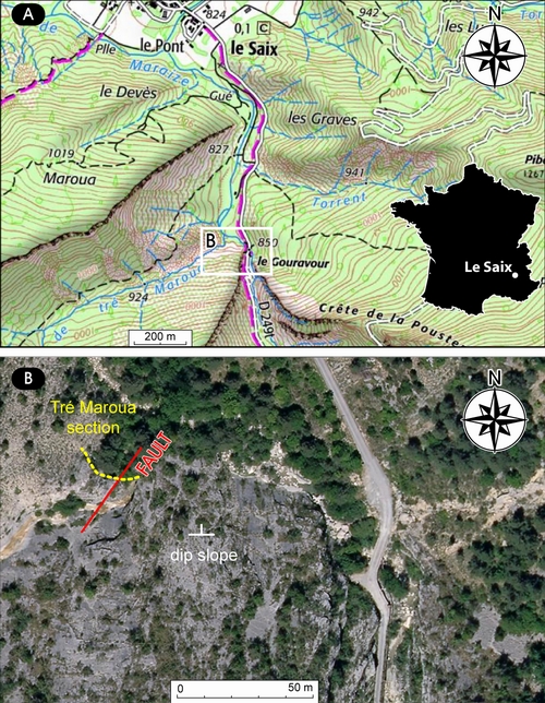
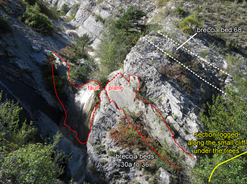
The Tré Maroua section is sited some 500 m
south of the village of Le Saix (Hautes-Alpes, France) on the left bank of the
Maraize stream near its junction with the Tré Maroua stream, one of its small
tributaries (GPS coordinates: 44°28'00.2"N, 5°49'42.0"E). Its
location (Fig. 1 ![]() )
corresponds to the SW corner of the geological map at 1/50,000
scale of Gap (Gidon, 1971).
)
corresponds to the SW corner of the geological map at 1/50,000
scale of Gap (Gidon, 1971).
|
Figure 1:
A) Topographic map of the area S of Le
Saix, centered on the Tré Maroua section (white frame); B) Satellite image of
the Tré Maroua section (yellow dots) and the fault (red line) affecting it. Map
and image backgrounds © IGN 2020. |
Based on the information presented by the BWG in
Bratislava and Milano, a transition interval was logged and samples taken around the
candidate boundary at Tré Maroua (Fig. 3.B ![]() ). Until recently, the only published
description of the section was the one briefly outlined by Le Hégarat
(1973: p. 392-395, Fig. 27; here Fig. 2.B
). Until recently, the only published
description of the section was the one briefly outlined by Le Hégarat
(1973: p. 392-395, Fig. 27; here Fig. 2.B ![]() ). According to the original text
description (Le Hégarat, 1973: p. 392-395), the section comprises only
one "mince passée bréchique (0,20-0,25 m) à éléments multicolores"
[thin breccia layer (0.20-0.25 m) with multicoloured clasts] labelled TT22 (Fig.
2.B
). According to the original text
description (Le Hégarat, 1973: p. 392-395), the section comprises only
one "mince passée bréchique (0,20-0,25 m) à éléments multicolores"
[thin breccia layer (0.20-0.25 m) with multicoloured clasts] labelled TT22 (Fig.
2.B ![]() ). More recently, Wimbledon et al.
(2020) reported 2 breccia layers in the transition interval
whereas the present authors report at least 6 breccia layers and associated
erosional surfaces (Fig. 3.B
). More recently, Wimbledon et al.
(2020) reported 2 breccia layers in the transition interval
whereas the present authors report at least 6 breccia layers and associated
erosional surfaces (Fig. 3.B ![]() ). In the "notice explicative" of the
geological map of Gap, Gidon (1971) refers to such breccias as "poudingues".
). In the "notice explicative" of the
geological map of Gap, Gidon (1971) refers to such breccias as "poudingues".
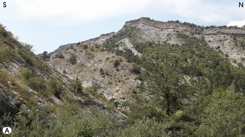
Figure 2: A) The Tré Maroua valley; B) The Tré Maroua section according to Le Hégarat (1973: Fig. 27): JAC Jacobi Zone, GRA Grandis Zone, SUB Subalpina Subzone, PRI Privasensis Subzone, DAL Dalmati Subzone, BOI Boissieri Zone, PAR Paramimounum Subzone, PIC Picteti Subzone, CAL Callisto Subzone, RPU Roubaudi Zone, PER Petransiens Subzone. |
|
|
Figure 3:
A)
Upper part of the short section
with the breccia bed no. 68; B) Short section with the transition interval of
the Tithonian to the Berriasian. The locations of the plugs taken by the BWG for
the (bio-) magnetostratigraphic study are reported as red circles. The fault
plane is located on the waterfall (Fig. 7 |
|
|
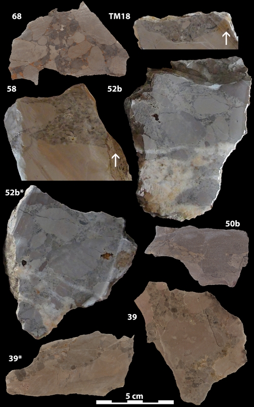
More than 40 samples were collected through this
short outcrop, i.e., a 15-meter
measured section. All rock pieces were later cut to better document the
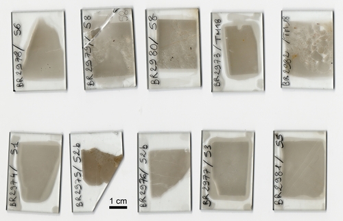
macroscopic fabrics (Table 1). Some were then photographed and others scanned (Figs. 4 ![]() - 5
- 5 ![]() ). Only 10 thin sections (Fig.
6
). Only 10 thin sections (Fig.
6 ![]() )
were prepared from a set of samples
chosen to frame the boundary in order to study the microfacies and the
calpionellid assemblages (Pls. 1
)
were prepared from a set of samples
chosen to frame the boundary in order to study the microfacies and the
calpionellid assemblages (Pls. 1 ![]() - 2
- 2 ![]() - 3
- 3 ![]() ). The preliminary microbiostratigraphic
results are rather puzzling because calpionellid Zone B (e.g., Remane,
1970, Benzaggagh, 2019), the base of which is the primary criterion of
the BWG (Wimbledon et al., 2019,
2020), is found to extend at least 2.5 m below the boundary location of
the BWG.
). The preliminary microbiostratigraphic
results are rather puzzling because calpionellid Zone B (e.g., Remane,
1970, Benzaggagh, 2019), the base of which is the primary criterion of
the BWG (Wimbledon et al., 2019,
2020), is found to extend at least 2.5 m below the boundary location of
the BWG.
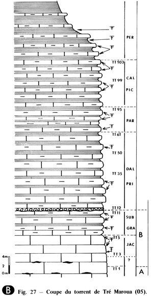
The locations of the plugs taken by the BWG for
their (bio-) magnetostratigraphic study were still visible (Fig.
2.A ![]() )
and are
reported on our log (Fig. 3.B
)
and are
reported on our log (Fig. 3.B ![]() ), thus allowing a short comment on the relevant
results presented by the BWG (Wimbledon et al., 2020).
), thus allowing a short comment on the relevant
results presented by the BWG (Wimbledon et al., 2020).
Table 1: Sample analyses and plate captions.
| Sample number | Macrofacies | Microfacies | Microbiostratigraphy (Plate captions) |
| 68 (Fig. 4 |
extraclastic rudstone (pebbles up to 35 mm in length) | ||
| TM24 (Fig. 5 |
contact of a mudstone and a turbidite mudstone | ||
| TM18 (Fig. 4 |
contact of a bioturbated mudstone and an extraclastic rudstone (pebbles up to 15 mm in length) | mudstone (Fig.
6 |
|
| 58 (Fig. 4 |
contact of a mudstone and an extraclastic rudstone (pebbles up to 25 mm in length) | rudstone with mudstone extraclasts and a bioclastic and extraclastic wackestone matrix
(Fig.
6 |
BR2979/58
extraclasts: mostly from Zone B (Subzone B1); some with more Crassicollaria spp., i.e., Cr. intermedia and Cr. brevis, and rare Calpionella elliptalpina could be ascribed to Zone A. (Pl. 3 |
| 56 | mudstone | mudstone
with calpionellids (Fig.
6 |
|
| 55 | bioturbated mudstone | mudstone
with calpionellids (Fig.
6 |
|
| 53 | mudstone | mudstone
with calpionellids (Fig.
6 |
|
| 52b (Fig. 4 |
extraclastic rudstone (pebbles up to 40 mm in length) | rudstone with mudstone extraclasts and a bioclastic and extraclastic wackestone matrix
(Fig.
6 |
BR2976/52b
large extraclast: numerous small and medium-sized spherical forms of Calpionella alpina with common Crassicollaria parvula; few ? Tintinnopsella carpathica and rare Calpionella grandalpina. Zone B (Subzone B1) (Pl. 2 |
| 51 | bioturbated mudstone | mudstone with calpionellids (Fig.
6 |
BR2974/51: small and medium-sized spherical forms of Calpionella alpina dominate over rare Crassicollaria parvula. Zone B (Subzone B1) (Pl. 1 |
| 50b (Fig. 4 |
extraclastic rudstone (pebbles up to 20 mm in length) | ||
| 39 (Fig. 4 |
contact of a mudstone and an extraclastic rudstone (pebbles up to 40 mm in length) |
Outcrops of the Tithonian-Berriasian interval in SE France are riddled with breccia and mud turbidite beds together with stratigraphic hiatuses that are hard to identify without an accurate biostratigraphy (e.g., Alliot et al., 1964; Remane, 1970; Le Hégarat, 1973). Courjault (2011) did extensive field work in Tithonian strata across the Diois and Baronnies regions, including a detailed study of the Drôme River lobe (Courjault et al., 2011). His contribution was recently completed in higher strata in the Le Chouet area (Ferry & Granier, 2019) where a large number of cryptic mud turbidites have been found in the "Calcaires blancs" Formation together with some more breccia beds.
The Tré Maroua section (Le Hégarat, 1973: Fig. 27; here Fig. 2.B ![]() )
partly revised herein was situated on a peeled and
gullied slope between two deep-water terraces, on the distal edge of the Drôme
River lobe. Gravity reworkings on this paleoslope fed the Céüse lobe to the NE
(Ferry et al., 2015) and the
section itself was located southwestward along this slope.
)
partly revised herein was situated on a peeled and
gullied slope between two deep-water terraces, on the distal edge of the Drôme
River lobe. Gravity reworkings on this paleoslope fed the Céüse lobe to the NE
(Ferry et al., 2015) and the
section itself was located southwestward along this slope.
A long section (not illustrated here) was
measured along the narrow road at the entry of the Gouravour gorge. Starting
from the bottom, the first fifteen meters, which consist mostly of well-bedded
limestones, locally argillaceous, are ascribed to the Kimmeridgian whereas the
following forty meters of slump and "breccia" beds are ascribed to the
Tithonian (e.g., Ferry & Grosheny,
2013; Ferry, 2017). The transition interval of the Tithonian to the
Berriasian itself is found in the next unit, i.e.,
in the "Calcaires blancs" Formation. The short section (Fig. 3.B ![]() )
covering the lowermost part of this last unit was measured along a small cliff
with a waterfall that marks the end of the Tré Maroua ravine (see §
"Location of the section, material and method").
)
covering the lowermost part of this last unit was measured along a small cliff
with a waterfall that marks the end of the Tré Maroua ravine (see §
"Location of the section, material and method").
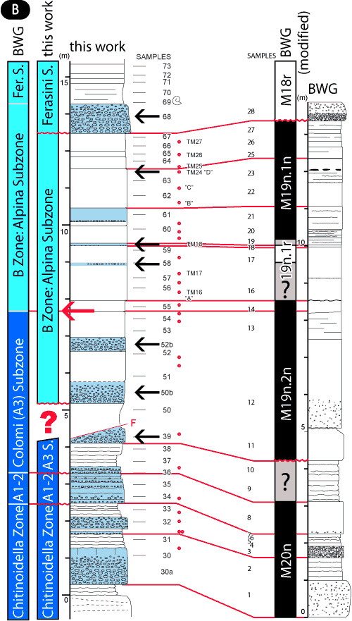
According to the log of the BWG (Wimbledon
et al., 2020: Fig. 4), the 8 to 9
meter thick transitional interval in which is located the Tithonian/Berriasian
boundary begins and ends with decimetric to metric conglomeratic layers,
which correspond respectively to our samples no. 50b and no. 68 (Fig. 4 ![]() ).
Contrary to a statement of the BWG (Wimbledon, personal communication,
January 2nd, 2020), the interval sandwiched by these breccias was not the site
of continuous sedimentation. As a matter of fact, the present authors document
here unreported occurrences of several additional conglomeratic layers (of which
at least 3 were sampled) and their associated basal erosional
surfaces/disconformities (Fig. 4
).
Contrary to a statement of the BWG (Wimbledon, personal communication,
January 2nd, 2020), the interval sandwiched by these breccias was not the site
of continuous sedimentation. As a matter of fact, the present authors document
here unreported occurrences of several additional conglomeratic layers (of which
at least 3 were sampled) and their associated basal erosional
surfaces/disconformities (Fig. 4 ![]() ): ca.
1 m below the boundary (sample no. 52b), ca.
1 m and 1.5 m above the boundary (samples no. 58 and no. TM18). The fabrics
of these conglomerates correspond mostly to rudstones (or quite a few
floatstones) with wackestone or packstone matrices. Pebbles and cobbles are
polygenetic (which can be detected from their color); they are subrounded in
shape and have a medium sphericity (Fig. 4
): ca.
1 m below the boundary (sample no. 52b), ca.
1 m and 1.5 m above the boundary (samples no. 58 and no. TM18). The fabrics
of these conglomerates correspond mostly to rudstones (or quite a few
floatstones) with wackestone or packstone matrices. Pebbles and cobbles are
polygenetic (which can be detected from their color); they are subrounded in
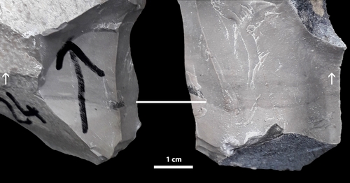
shape and have a medium sphericity (Fig. 4 ![]() ). Our preliminary investigation
suggests there are also some unreported mud turbidites and associated basal
erosional surfaces, i.e., features
that are generally harder to identify directly in the field (e.g.,
sample no. TM24, Fig. 5
). Our preliminary investigation
suggests there are also some unreported mud turbidites and associated basal
erosional surfaces, i.e., features
that are generally harder to identify directly in the field (e.g.,
sample no. TM24, Fig. 5 ![]() )
and would require a more systematic sampling program.
As a consequence, contrary to the views of the BWG, the interval sandwiched
between these breccias was also affected by changes in the rate of
sedimentation: positive but low for the pelagic ooze (0.01 m/k.y. as an order of
magnitude), positive and very high for turbidites and debris flows (1 m/hour as
an order of magnitude), negative and very high for the erosional surfaces at the
bottom of turbidites and debris flows (-1 m/hour as an order of magnitude).
Whether a breccia bed is thin or thick, the base of any unit (biozone or
biomagnetozone) should be necessarily located at its bottom, not at its top.
)
and would require a more systematic sampling program.
As a consequence, contrary to the views of the BWG, the interval sandwiched
between these breccias was also affected by changes in the rate of
sedimentation: positive but low for the pelagic ooze (0.01 m/k.y. as an order of
magnitude), positive and very high for turbidites and debris flows (1 m/hour as
an order of magnitude), negative and very high for the erosional surfaces at the
bottom of turbidites and debris flows (-1 m/hour as an order of magnitude).
Whether a breccia bed is thin or thick, the base of any unit (biozone or
biomagnetozone) should be necessarily located at its bottom, not at its top.
|
Figure 4:
From top to bottom, unless otherwise
stated, mostly some randomly cut polished slabs of the "breccia"
samples observed on the occasion of our preliminary investigation on the
transition interval: scanned surface of no. 68 (upper conglomerate), photographed
surface of no. TM18
oriented (arrow pointing upward), photographed surface of no. 58 oriented (arrow pointing
upward), photographed surfaces of no. 52b, scanned surface of no. 50b (lower conglomerate), scanned
surfaces of no.
39. |
|
Figure 5:
One example of a mud turbidite with
its erosional base identified from the field: photographed surface of no. TM24
oriented (arrows
pointing upward). |
The situation is almost the same as in the Le Chouet section. As recently highlighted by Ferry and Granier (2019) and contrary to the opinion of Wimbledon et al. (2013), this "complementary" section of the BWG, which is duly listed as such in their "plexus of sites", also does not comply with the fundamental criterion consisting of an "essentially continuous sedimentation, uninterrupted by marked diastems".
Furthermore, contrary to a statement of the BWG
(Wimbledon, personal communication, January 2nd, 2020), a fault affects
the section. The corresponding fault plane (Fig. 7 ![]() ), ca. 3 m below the boundary, is partly visible at the waterfall that
marks the end of the Tré Maroua ravine (videos at https://carnetsgeol.net/cg/20/01/TMF.mp4 or https://carnetsgeol.net/cg/20/01/TMF.avi).
), ca. 3 m below the boundary, is partly visible at the waterfall that
marks the end of the Tré Maroua ravine (videos at https://carnetsgeol.net/cg/20/01/TMF.mp4 or https://carnetsgeol.net/cg/20/01/TMF.avi).
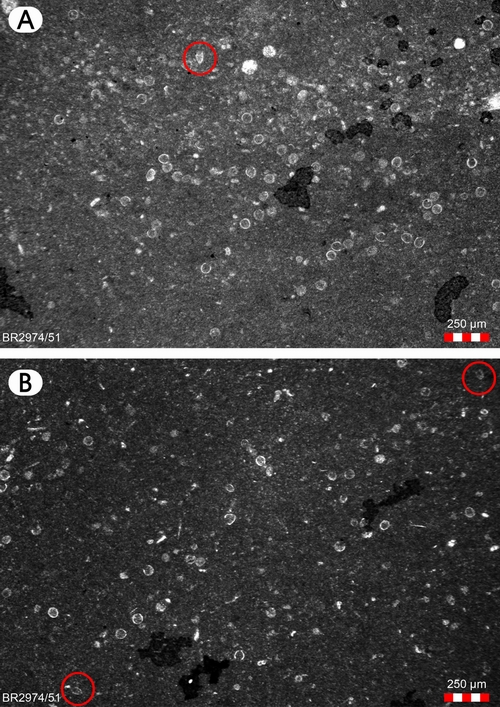
The primary criterion defined by the BWG to identify the base Berriasian (e.g., Wimbledon et al., 2019) is the base of calpionellid Zone B, i.e., the base of the acme of Calpionella alpina, also called the "Crassicolaria/Calpionella turnover" because there the small and medium-sized spherical forms of Calpionella alpina take over the Crassicolaria spp.
According to Wimbledon et
al. (2020: Fig. 4), the Tithonian/Berriasian boundary should be located
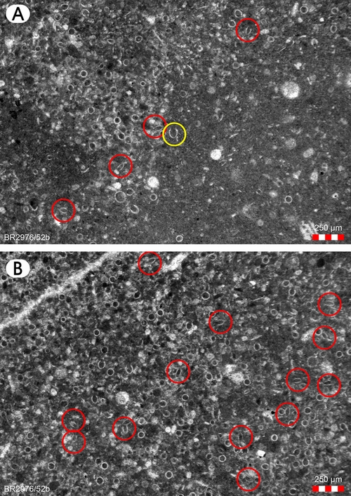
between our samples no. 54 and no. 55. However, our sample no. 52b was taken
from a breccia bed ca. 1 m below the
boundary and at least one pebble was found to contain an assemblage
characteristic of Zone B (Pl. 2 ![]() , figs.
A-B, red circles: Crassicolaria spp.;
yellow circle: Calpionella sp.). Furthermore our sample no. 51 was taken ca. 2 m below the boundary and again the corresponding thin section
displays an assemblage characteristic of Zone B
(Pl. 1
, figs.
A-B, red circles: Crassicolaria spp.;
yellow circle: Calpionella sp.). Furthermore our sample no. 51 was taken ca. 2 m below the boundary and again the corresponding thin section
displays an assemblage characteristic of Zone B
(Pl. 1 ![]() ,
figs. A-B, red circles: Crassicolaria
spp.). Consequently, the Tithonian/Berriasian boundary is probably lower in
the section, thus getting closer to breccia beds and to the fault. According to Ferry
and Granier (2019), this same boundary defined by Wimbledon et
al. (2020) was also found 2 meters higher than that defined by Remane
(1970) at Le Chouet.
,
figs. A-B, red circles: Crassicolaria
spp.). Consequently, the Tithonian/Berriasian boundary is probably lower in
the section, thus getting closer to breccia beds and to the fault. According to Ferry
and Granier (2019), this same boundary defined by Wimbledon et
al. (2020) was also found 2 meters higher than that defined by Remane
(1970) at Le Chouet.
Besides, the calpionellid Zone A sensu
Wimbledon et al. (2020), i.e., the Crassicolaria Zone, which represents the most part of the
upper Tithonian, is only some 6 meters thick at Tré Maroua whereas it could be
less than 3 meters according to the present authors (Fig. 3.B ![]() ).
).
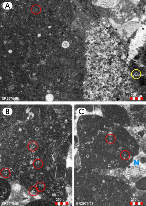
Our sample no. 58 was taken from a breccia bed ca.
5 m above the boundary. The many extraclasts observed in the corresponding thin
sections are barren or contain discrete assemblages, either from Zone B or older
from Zone A (Pl. 3 ![]() , figs.
A-C: Crassicolaria spp.; yellow circle: Calpionella
sp.; blue N: Neotrocholina sp.). They document significant erosional
events and coeval reworkings taking place in the whole area in the late
Tithonian - early Berriasian interval.
, figs.
A-C: Crassicolaria spp.; yellow circle: Calpionella
sp.; blue N: Neotrocholina sp.). They document significant erosional
events and coeval reworkings taking place in the whole area in the late
Tithonian - early Berriasian interval.
|
Figure 6:
The limited set of thin sections [from
samples no. 51, no. 52b (2), no. 53, no. 55, no. 56, no. 58 (2), no. TM18 (2)]
studied herein. Extraclasts are visible in BR2975-2976, 2979-2980, and 2982. |
One self-defined requirement of the BWG was that the Berriasian GSSP candidate section should have a complete record of a transition interval spanning the whole Magnetozone M19n (Wimbledon et al., 2020: Fig. 9), which is a secondary correlation marker bracketing the primary marker.
On
one hand, the base of the Magnetozone M18r at Tré Maroua is located at the
bottom of the breccia bed no. 68, not at its top (Fig. 3.B ![]() ), which implies that
the top of M19n corresponds to an erosional surface with an associated hiatus.
On the other hand, the Magnetozone M20r was not identified; therefore, the base
of M19n could not be properly defined. Accordingly, the record of Magnetozone
M19n is incomplete.
), which implies that
the top of M19n corresponds to an erosional surface with an associated hiatus.
On the other hand, the Magnetozone M20r was not identified; therefore, the base
of M19n could not be properly defined. Accordingly, the record of Magnetozone
M19n is incomplete.
Additionally, the whole transition interval
comprises several episodes of erosion accompanied by the deposition of mud
turbitides and conglomerates resulting from debris flows (Fig. 5 ![]() ), as it is also
the case at Le Chouet (Ferry & Granier,
2019). These episodes
do not appear on the log of Wimbledon et al. (2020: Fig. 4).
), as it is also
the case at Le Chouet (Ferry & Granier,
2019). These episodes
do not appear on the log of Wimbledon et al. (2020: Fig. 4).
To summarize, the sedimentary record of M19n is clearly incomplete and fragmentary.
Finally, remember that a fault is also visible (Fig. 7 ![]() )
and that it affects the section within the Magnetozone M19n, most
specifically near its base (Fig. 3.B
)
and that it affects the section within the Magnetozone M19n, most
specifically near its base (Fig. 3.B ![]() ).
).
|
Figure 7:
The fault plane on the waterfall that
marks the end of the Tré Maroua ravine (see the video at https://carnetsgeol.net/cg/20/01/TMF.mp4 or https://carnetsgeol.net/cg/20/01/TMF.avi). |
1) According to Remane et al. (1996), a GSSP section should meet a number of "geological requirements":
| i. "Exposure over an adequate thickness of sediments is one requirement to guarantee that a sufficient time interval is represented by the section, so that the boundary can also be determined by interpolation, using auxiliary markers close to the boundary." | |
| see § "Remarks on microbiostratigraphy" Incompletness of the interval spanning the Colomi Subzone of the Crassicolaria Zone (A3) and the Alpina Subzone of the Calpionella Zone (B1): hiatuses related to erosional surfaces are identified at the bottom and the top of this Colomi-Alpina interval. see § "Remarks on biomagnetostratigraphy" Incompletness of Magnetozone M19n: a hiatus related to an erosional surface is identified at the its top whereas its base could not be precisely identified. |
|
| ii. "Continuous sedimentation: no gaps, no condensation in proximity of the boundary level." | |
| In the transition interval, Le Hégarat
(1973) reported only one breccia layer whereas Wimbledon et
al. (2020) report two breccia layers. The present authors documented at
least 6 breccia layers and associated erosional surfaces (Fig. 3.B see § "Remarks on microbiostratigraphy" Fragmentary record of the interval spanning the Colomi Subzone of the Crassicolaria Zone (A3) and the Alpina Subzone of the Calpionella Zone (B1): hiatuses related to erosional surfaces are identified within this Colomi-Alpina interval. As documented herein, it is more than possible that the (A3/B1) boundary itself coincides with the erosional surface at the base of the breccia bed no. 50b (Fig. 3.B see § "Remarks on biomagnetostratigraphy" Fragmentary record of Magnetozone M19n: hiatuses related to erosional surfaces are identified within the Magnetozone M19n. |
|
| iii. "The rate of sedimentation should be sufficient that successive events can be easily separated." | |
| see § "Remarks on lithostratigraphy and
sedimentology" The rate of sedimentation was changing from highly negative (-1 m/hour as an order of magnitude) to highly positive (1 m/hour as an order of magnitude), then to still positive but very low (0.01 m/k.y. as an order of magnitude). |
|
| iv. "Absence of synsedimentary and tectonic disturbances." | |
| see previous items i) and ii) for the breccia
beds, mud turbidites, and associated erosional surfaces. The present authors report a fault ca. 3 m below the base of Calpionella Zone (B) sensu Wimbledon et al. (2020). As documented herein, it is more than possible that the (A3/B1) boundary itself is located even closer (ca. 1 m) to the fault (see Fig. 3.B |
|
| v. "Absence of metamorphism and strong diagenetic alteration (identification of magnetic and geochemical signals)." | |
| Some rock samples are fractured and cemented by
calcite (for instance, our sample no. 52b is a tectonically-brecciated
sedimentary breccia, see Fig. 4 |
|
As demonstrated above, the Berriasian GSSP candidate section at Tré Maroua (Fig. 3.B ![]() )
does not meet at least four of the above five "geological
requirements for a GSSP". Although this candidacy reached the absolute
majority of the votes of the BWG, it must be dismissed for the sake of
stratigraphers' confidence in the selection of GSSPs. Looking ahead, a careful
regional investigation should be the prerequiste to any future attempt to
identify a better location for a recasted Berriasian GSSP.
)
does not meet at least four of the above five "geological
requirements for a GSSP". Although this candidacy reached the absolute
majority of the votes of the BWG, it must be dismissed for the sake of
stratigraphers' confidence in the selection of GSSPs. Looking ahead, a careful
regional investigation should be the prerequiste to any future attempt to
identify a better location for a recasted Berriasian GSSP.
2) As a result of the inability to present a tenable Berriasian stage boundary within the Jacobi-Grandis standard ammonite zone interval, as well as the instability of the proposed boundary location over decades and the obvious lack of a significant biological crisis (see Granier, ed., 2019a; Granier, 2019b, 2019c, 2019d; Vörös et al., 2019; Énay, 2020; Salazar et al., 2020), one should definitely close the chapter of its candidacy as the Jurassic/Cretaceous system boundary opened by Kilian (e.g., 1910) almost a century ago. It would be obtuse to keep on looking for a system boundary where one can hardly identify a stage boundary. It is suggested here again to revert to the pre-Kilian historical boundary, i.e., the boundary of Oppel (e.g., 1865, for the last stage of the Jurassic), Toucas (e.g., 1908), or Orbigny (e.g., 1842, for the first stage of the Cretaceous). It should be now a reality that the only valid option remaining consists of shifting the Jurassic/Cretaceous boundary back to the base Valanginian (as has been urged in some recent discussions, e.g., Granier, 2019c; Énay, 2020).
This manuscript benefited from the constructive comments of several reviewers, anonymous or not. With regard to the calpionellids, the present authors would like to thank Silviya Petrova, Iskra Lakova, Andrzej Pszczólkowski and Joachim Blau for having shared their opinions with us. Thanks go also to Pascal Tieffenbach for having prepared the thin sections. The authors are grateful to Phil Salvador who kindly agreed to check the English text. This short paper is dedicated to Amos Salvador, his father, the stratigraphic contributions of whom (e.g., A. Salvador, 1994; Murphy & A. Salvador, 1999) have been inspiring for the first author (BG).
Alliot C., Flandrin J. & Moullade M. (1964).- Les sédiments grossiers du Berriasien de la "Fosse vocontienne". Étude particulière du Berriasien de Marignac au N.O. de Die (Drôme).- Travaux et Documents des Laboratoires de Géologie de Lyon (nouvelle série), no. 11, p. 161-182.
Benzaggagh M. (2019).- Discussion on the calpionellid biozones and proposal of a homogeneous calpionellid zonation for the Tethysian Realm. In: Granier B. (ed.), Virtual Special Issue on "The transition of the Jurassic to the Cretaceous: an early XXIth century holistic approach".- Cretaceous Research. DOI: 10.1016/j.cretres.2019.07.014
Courjault T. (2011).- Brèches gravitaires sous-marines du Tithonien subalpin (S-E France).- PhD thesis, Université de Strasbourg, 339 p.
Courjault T., Grosheny D., Ferry S. & Sausse J. (2011).- Detailed anatomy of a deep-water carbonate breccia lobe (Upper Jurassic, French subalpine basin).- Sedimentary Geology, vol. 238, no. 1-2, p. 156-171.
Énay R. (2020).- The Jurassic/Cretaceous System Boundary is at an impasse. Why not go back to Oppel's 1865 original and historic definition of the Tithonian?.- Cretaceous Research, vol. 106, no. 104241, 20 p. DOI: 10.1016/j.cretres.2019.104241
Ferry S. (2017).- Summary on Mesozoic carbonate deposits of the Vocontian Trough (Subalpine Chains, SE France). In: Granier B. (ed.), Some key Lower Cretaceous sites in Drôme (SE France).- Carnets de Géologie, Madrid, Book 2017/01 (CG2017_B01), p. 9-42.
Ferry S. & Granier B. (2019).- 12. Looking for the Jurassic-Cretaceous system boundary in the Vocontian Trough (S-E France): sedimentological problems. In: Granier B. (ed.), JK2018 - International Meeting around the Jurassic-Cretaceous Boundary (Geneva, December 5-7, 2018). Abstract volume.- Carnets de Géologie, Madrid, Book 2019/01 (CG2019_B01), p. 24.
Ferry
S. & Grosheny D. (2013).- Turbidites et brèches carbonatées (Jurassique
et Crétacé du bassin subalpin).- Livret-Guide Excursion ASF-GFC, 20-23
septembre 2013, 101 p. URL: http://hal.archivesouvertes.fr/docs/00/90/81/77/PDF/
2013_Turbidites_SE_ExcuGFC.pdf
Ferry S., Grosheny D., Atrops F. & Backert N. (2015).- The base-of-slope carbonate breccia system of Céüse (Tithonian, S-E France): occurrence of progradational stratification in the head plug of coarse granular flow deposits.- Sedimentary Geology, vol. 317, p. 71-86.
Gidon M. (1971).- Gap.- Carte géologique détaillée de la France au 1/50 000, BRGM, Orléans-la-Source, Feuille 001III - 38, 15 p., 1 map.
Granier B. (ed., 2019a).- JK2018 - International Meeting around the Jurassic-Cretaceous Boundary (Geneva, December 5-7, 2018). Abstract volume.- Carnets de Géologie, Madrid, Book 2019/01 (CG2019_B01), 100 p.
Granier B. (2019b).- Dual biozonation scheme (benthic foraminifera and "calcareous" green algae) over the Jurassic-Cretaceous transition. Another plea to revert the system boundary to its historical Orbigny's and Oppel's definition. In: Granier B. (ed.), Virtual Special Issue on "The transition of the Jurassic to the Cretaceous: an early XXIth century holistic approach".- Cretaceous Research, vol. 93, p. 245-274. DOI: 10.1016/j.cretres.2018.08.024
Granier B. (2019c).- JK2018: International Meeting around the Jurassic/Cretaceous Boundary - Chairperson's Report.- Volumina Jurassica, Warszawa, vol. XVII, p. 1-6.
Granier B. (2019d).- Carbonate platforms of the Tethys Ocean at the Jurassic-Cretaceous transition: case studies. In: Fekete K., Michalík J. & Reháková D. (eds.), Field Trip Guide and Abstracts Book, XIVth Jurassica Conference & Workshop of the ICS Berriasian Group (June 10-14, 2019, Bratislava, Slovakia).- Earth Science Institute, Slovak Academy of Sciences & Faculty of Natural Sciences, Comenius University, Bratislava, p. 113-114.
Kilian W. (1910).- La faune des couches à Hoplites boissieri (Pictet) (Berriasien p.p. - Valanginien inférieur) du Sud-Est de la France.- Association française pour l'Avancement des Sciences, Congrès de Lille, p. 476-496.
Le Hégarat G. (1973).- Le Berriasien du Sud-Est de la France.- Thèse Docteur ès Sciences naturelles, no. 149, Université Claude Bernard - Lyon; Documents du Laboratoire de Géologie de la Faculté de Lyon, no. 43 (1971), 2 fasc., 576 p. (55 Pls.).
Murphy M.A. & Salvador A. (1999).- International Stratigraphic Guide - An abridged version.- Episodes, vol. 24, no. 4, p. 255-271.
Oppel A. (1865).- 2. Die Tithonische Etage.- Zeitschrift der Deutschen geologischen Gesellshaft, Berlin, Band XVII, p. 535-558.
Orbigny A. d' (1842-1851).- Paléontologie Française, Terrains Jurassiques, I. Céphalopodes.- Bertrand, Paris, 642 p.
Remane J. (1970).- Die Entstehung der resedimentären Breccien im Obertithon der subalpinen Ketten Frankreichs.- Dissertation (1969), Göttingen; Eclogae geologicae Helvetiae, vol. 63, no. 3, p. 685-740.
Remane J., Bassett M.G., Cowie J.W., Gohrbandt K.H., Lane R.L., Michelsen O. & Wang N. (1996).- Revised guidelines for the establishment of global chronostratigraphic standards by the International Commission on Stratigraphy (ICS).- Episodes, vol. 19, no. 3, p. 77-81.
Salazar C., Stinnesbeck W. & Álvarez M. (2020).- Ammonite biostratigraphy and bioevents in the Jurassic - Cretaceous boundary of central Chile. In: Granier B. (ed.), Virtual Special Issue on "The transition of the Jurassic to the Cretaceous: an early XXIth century holistic approach".- Cretaceous Research, vol. 107, no. 104282, 16 p. DOI: 10.1016/j.cretres.2019.104282
Salvador A. (ed., 1994).- International Stratigraphic Guide.- I.U.G.S. & Geological Society of America, 214 p.
Toucas A. (1908).- Sur le Tithonique et le Berriasien.- Compte Rendu Sommaire des Séances de la Société géologique de France, Paris, Séance du 6 janvier 1908, p. 25-27.
Vörös A., Főzy I. & Szives O. (2019).- Brachiopod distribution through the Jurassic-Cretaceous transition in the western Tethyan pelagic realm: Example from the Bakony Mountains, Hungary. In: Granier B. (ed.), Virtual Special Issue on "The transition of the Jurassic to the Cretaceous: an early XXIth century holistic approach".- Cretaceous Research, vol. 104, no. 104182, 9 p. DOI: 10.1016/j.cretres.2019.104182
Wimbledon W.A.P, Reháková D., Halásová E., Lintnerová O., Michalík J., Pruner P., Schnabl P., Svobodová A., Číková K., Elbra T., Koták M., Arnaud-Vanneau A.M., Galbrun B., Gardin S., Bulot L.G., Frau C., Grabowski J., Wierzbowski A., Pszczółkowski A., Stoykova K., Ivanova D., Lakova I., Tchoumatchenko P., Sha J., Li G., Cao M., Wan X., Li J., Andreini G., Satolli S., Erba E., Poulton T.P., Galloway J., Riccardi A., Leanza H., Kietzmann D., Vennari V., Aguirre-Uretta B., Dzyuba O., Bugdaeva E., Markevich V., Guzhikov A., Vuks V., Riding J., Hunt C., Copestake P., Munsterman D., Verreussel R., Bakhmutov V., Főzy I., Mojon P.O., Mohialdeen I.J., Bardhan S., Lopez-Martinez R., Benzaggagh M., Alsen P., Vajda V., Ogg J. & Lucas-Clark J. (2019).- Progress with selecting a GSSP for the Berriasian Stage (Cretaceous) - illustrated by sites in France and Italy. In: Fekete K., Michalík J. & Reháková D. (eds.), Field Trip Guide and Abstracts Book, XIVth Jurassica Conference & Workshop of the ICS Berriasian Group (June 10-14, 2019, Bratislava, Slovakia).- Earth Science Institute, Slovak Academy of Sciences & Faculty of Natural Sciences, Comenius University, Bratislava, p. 186-187.
Wimbledon W.A.P., Reháková D., Pszczółkowski A., Casellato C.E., Halásová E., Frau C., Bulot L.G., Grabowski J., Sobień K., Pruner P., Schnabl P. & Číková K. (2013).- An account of the bio- and magnetostratigraphy of the Upper Tithonian-Lower Berriasian interval at Le Chouet, Drôme (SE France).- Geologica Carpathica, Bratislava, vol. 64, no. 6, p. 437-460.
Wimbledon W.A.P., Reháková D., Svobodová A., Schnabl P., Pruner P., Elbra T., ifnerová K., Kdýr ., Frau C., Schnyders J. & Galbrun B. (2020).- Fixing a J/K boundary: a comparative account of key Tithonian-Berriasian profiles in the departments of Drôme and Hautes-Alpes, France.- Geologica Carpathica, Bratislava, vol. 71, no. 1, p. 24-46.
Plate
1, figs. A-B: BR2974/51:
small and medium-sized spherical forms of Calpionella
alpina dominate over rare Crassicollaria parvula. All photos: graphical scale bar = 250 µm. |
|
|
Plate
2, figs. A-B:
BR2976/52b
large extraclast:
numerous small and medium-sized spherical forms of Calpionella
alpina with common Crassicollaria parvula; few ? Tintinnopsella carpathica
and rare Calpionella grandalpina. All photos: graphical scale bar = 250 µm. |
|
|
Plate 3, figs. A-B: BR2979/58 extraclasts: mostly from Zone B (Subzone B1); some with more Crassicollaria spp., i.e., Cr. intermedia and Cr. brevis, and rare Calpionella elliptalpina could be ascribed to Zone A. All photos: graphical scale bar = 250 µm. |
|