Carnets de Géologie / Notebooks on Geology: Book 2009/03, Chapter 10 (CG2009_B03/10)
![]()
![]()
T. (2009).- Copper Canyon track locality (Pliocene) conservation strategies, Death Valley National Park, USA.- In: J.H. & B.R.C. (eds.), PaleoParks - The protection and conservation of fossil sites worldwide.- Carnets de Géologie / Notebooks on Geology, Brest, Book 2009/03, Chapter 10 (CG2009_B03/10)
Copper Canyon within Death Valley National Park, California, USA, preserves literally hundreds of in situ fossil mammal and bird tracks spanning over 3000 meters of lacustrine Pliocene deposits. Management of the Copper Canyon track locality has included closure and photo-monitoring of the locality. Research currently underway will evaluate the photo-monitoring program and recommend set standards and protocols for in situ paleontological resources that will not only apply to the paleontological resources in Death Valley National Park but can be adapted to serve as a model throughout the US National Park Service. The Copper Canyon track locality is a perfect setting to test the implementation of management protocols of in situ paleontological resources.
Death Valley National Park; conservation; tracks; fossils; paleontology; Pliocene; Copper Canyon; Black Mountains; lacustrine.
Gestion et mise en valeur du site à pistes pliocènes du Copper Canyon, Parc National de la "Vallée de la Mort" (É.U.A.).- Situé à l'intérieur du Parc National de la Vallée de la Mort (Californie, États-Unis d'Amérique), les 3000 mètres de sédiments lacustres pliocènes du Copper Canyon recèlent des centaines de très belles pistes de mammifères et d'oiseaux. L'aménagement du canyon a consisté en l'édification d'une clôture et en la pose de panneaux explicatifs. Ces affichages, ainsi que les protocoles de mise en valeur des ressources paléontologiques in situ, sont l'objet d'une évaluation permanente de sorte à ce que ces initiatives ne soient pas confinées au seul parc de la Vallée de la Mort mais puissent servir à l'ensemble des parcs nationaux. Les pistes du Copper Canyon nous paraissent constituer un parfait support aux techniques de gestion et valorisation de gisements paléontologiques.
Parc national de la Vallée de la Mort ; préservation ; pistes ; fossiles ; paléontologie ; Pliocène ; Copper Canyon ; Montagnes Noires ; dépôts lacustres.
Death Valley National Park (USA) preserves the most abundant and diverse fossil track locality
(Fig. 1 ![]() ) in North America and possibly the world. To date, thirty-six ichnospecies of cat, camel, horse, Mastodon, and birds have been identified from the Pliocene lakeshore sediments of Copper Canyon (,
1939, 1941; ,
1986; , 1998; and ,
1999, 2000)
(Fig. 2
) in North America and possibly the world. To date, thirty-six ichnospecies of cat, camel, horse, Mastodon, and birds have been identified from the Pliocene lakeshore sediments of Copper Canyon (,
1939, 1941; ,
1986; , 1998; and ,
1999, 2000)
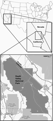
(Fig. 2 ![]() ). These tracks are significant because: 1) they represent a diverse fauna of large terrestrial mammals and birds, many of which have no body counterparts in the fossil record; 2) the tracks are preserved in lacustrine sediments deposited about 4mya within an environment clearly different than the one represented by current Death Valley climate conditions; and 3) fossil mammal and bird tracks preserved in Death Valley National Park and in other National Park Service areas provide important opportunities for public education and interpretation of in situ (found in their original position in a formation) fossils.
). These tracks are significant because: 1) they represent a diverse fauna of large terrestrial mammals and birds, many of which have no body counterparts in the fossil record; 2) the tracks are preserved in lacustrine sediments deposited about 4mya within an environment clearly different than the one represented by current Death Valley climate conditions; and 3) fossil mammal and bird tracks preserved in Death Valley National Park and in other National Park Service areas provide important opportunities for public education and interpretation of in situ (found in their original position in a formation) fossils.
Death Valley National Park, as are other land management agencies, is challenged with how to preserve in situ paleontological resources for future generations. Historically the general procedures for the conservation of in situ paleontological resources have been photo monitoring.
Although photo monitoring is a viable means of documenting in situ paleontological resources the fossil will eventually be lost to natural erosion or human/animal disturbance
(Fig. 3 ![]() ). Due to the usual size and potential loss of the fossil during excavation, collection of in situ fossils is usually not an option for park staff.
). Due to the usual size and potential loss of the fossil during excavation, collection of in situ fossils is usually not an option for park staff.
Research currently underway in Copper Canyon will: 1) review how effective the established photo-monitoring program is for the tracks of Copper Canyon and 2) review what conservation methods are available to land management agencies concerning in situ fossil resources.
The goal of this research is to assess conservation procedures for in situ paleontological resources and integrate them into park natural resource management language and procedures. The results of this research can be applied to the tracks in Copper Canyon and to other in situ paleontological resources within other land management areas. Although specific to the United States in some respects, these procedures may be applicable or modified for use in other countries.
(1939, 1941) was the first to document the fossil mammal and bird tracks of Copper Canyon. He refers to this deposit as the Copper Canyon Formation. Soon after 's discovery the Park Service closed Copper Canyon to the public due to the fragile nature of the resource.
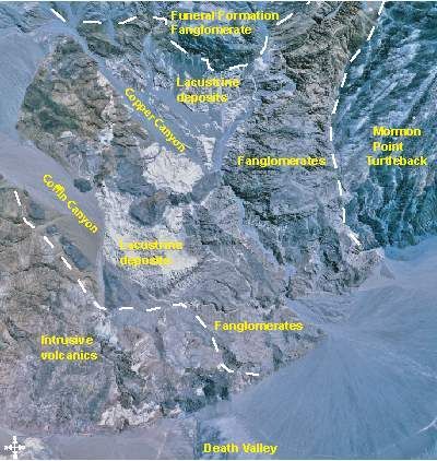
Tertiary rocks in Copper Canyon cover approximately ten square miles representing basin fill deposits of alternating lake and alluvial sediments
(Fig. 1 ![]() ). The Copper Canyon deposits most likely represent a lake shoreline due to the numerous mammal and bird tracks incorporated within them
(Fig. 2
). The Copper Canyon deposits most likely represent a lake shoreline due to the numerous mammal and bird tracks incorporated within them
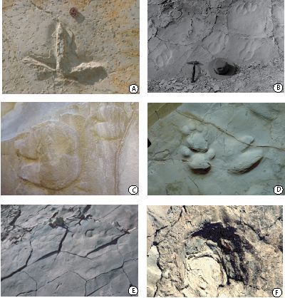
(Fig. 2 ![]() ). The Copper Canyon tracks are preserved in a fine-grained mudstone that is highly susceptible to erosion. Due to the almost vertical tilt of the track bearing rock layers, natural erosion and also landslides of the track layers destroy countless tracks each year
(Fig. 3.E
). The Copper Canyon tracks are preserved in a fine-grained mudstone that is highly susceptible to erosion. Due to the almost vertical tilt of the track bearing rock layers, natural erosion and also landslides of the track layers destroy countless tracks each year
(Fig. 3.E ![]() ). However, the potential track bearing layers cover over 3000 meters therefore as tracks are destroyed new track-bearing layers are exposed.
). However, the potential track bearing layers cover over 3000 meters therefore as tracks are destroyed new track-bearing layers are exposed.
The National Park Service Organic Act (1916) and the National Parks Omnibus Management Act (1998) authorize the preservation and stewardship of all park natural resources while identifying the need for science based decision-making. The National Park Service is mandated to provide protection of paleontological resources within congressionally authorized boundaries. However, there is a tremendous variability in erosional rates, specimen spatial distribution, abundance, and types of preservation. All of these variables result in a diversity of potential options for the selection or development of the proper management of these paleontological resources. Therefore the task of management and monitoring of paleontological resources has been challenging and difficult.
Previous management of the Copper Canyon track locality has consisted of photo monitoring, collection of scientifically important specimens, and the assessment of the erosional rates within Copper Canyon (, 1998; & , 1999). This research will expand upon previous management plans and evaluate:
Is the current management/monitoring of photo-monitoring a viable method to address erosion and human/animal disturbance (vandalism, theft) of the in situ mammal and bird tracks of Copper Canyon?
Since the 1940's Copper Canyon has been closed to the general public. Since that time photo monitoring has been used to document and evaluate tracks within Copper Canyon. However photo monitoring of the Copper Canyon tracks has been sporadic and no one up to now has gathered the data together to actually evaluate erosional or disturbance changes of the Copper Canyon tracks. The photo-monitoring program for the Copper Canyon tracks offers a unique opportunity to review and evaluate sixty years of photo monitoring of in situ paleontological resources.
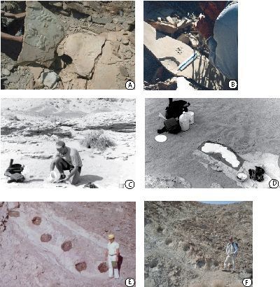
Protocols for the Copper Canyon track locality will consist of:
a) Periodic site assessment
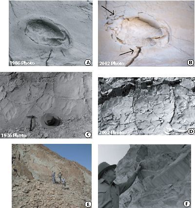
Periodic site assessment indicators involve assessing the relative turnover rate of surficial specimens at each fossil locality by monitoring the numbers of specimens destroyed (lost) or exposed (gained) at the surface
(Fig. 4.A ![]() ). Site assessments would report recommendations to further conserve the resource. The Copper Canyon track locality can be used as a template to develop a set of procedures and protocols for in situ paleontological resources.
). Site assessments would report recommendations to further conserve the resource. The Copper Canyon track locality can be used as a template to develop a set of procedures and protocols for in situ paleontological resources.
b) Photo-monitoring
Photo monitoring has been the usual procedure for the documentation and means to evaluate erosion and disturbance of in situ paleontological resources. The problems with photo-monitoring is that each photo is subject to the picture taker, angle of photograph, and the light source and in the end the only documentation of the fossil is in the form of photographs
(Fig. 4.B ![]() ). However photo-monitoring is an important first step in the conservation of in situ paleontological resources.
). However photo-monitoring is an important first step in the conservation of in situ paleontological resources.
c) Replication
Replication is a viable method to preserve casts and molds of in situ paleontological resources. Through a 1999 Death Valley National Park grant 56 individual tracks or track ways from in situ exposures in Copper Canyon were replicated using silicon based latex ( & ,
2000)
(Fig. 4.C-D ![]() ). In 2003, only twenty percent of the tracks and track ways replicated in 1999 could still be re-located. Turnover rates and loss of fossil tracks to erosion in Copper Canyon must be very high. Replication however is an expensive and invasive method of preserving in situ paleontological resources.
). In 2003, only twenty percent of the tracks and track ways replicated in 1999 could still be re-located. Turnover rates and loss of fossil tracks to erosion in Copper Canyon must be very high. Replication however is an expensive and invasive method of preserving in situ paleontological resources.
d) Vital signs monitoring program
The problem that both National Park Service areas and other land managers have in management of their paleontological resources has been in developing a set of standards to address the questions of how to measure the condition of paleontological resources and the application of consistent criteria. Because of different types of preservation these criteria will vary depending on the type of rock in which the fossils were deposited. The methodologies for tracks will be different from the approaches for petrified wood or bone. Since tracks are often left in place and are therefore exposed to variable weather conditions and long-term seasonal variations, the condition of the fossil is dependent upon the rock composition, erosional rates, and the preservation and survivorship potential of the fossil. The timing and nature of monitoring must take these variables into account. A means by which to assess these conditions and integrate them into park natural resource management language and procedures is a major goal of this research.
The National Park Service has developed a vital signs monitoring program using a system of indicators for monitoring an ecosystem's health. Paleontological resources at or near the surface will inevitably deteriorate over time. The idea of resource stability indicators that have been applied to other resources through the Vital Signs Program can also be applied to fossils. These indicators are categorized into three groups: climatological data assessment, rates of erosion assessments, and periodic site assessments.
Climatological data assessment indicators involves measurement and evaluation of factors such as annual precipitation, rainfall intensity, relative humidity, wind speed, and freeze/thaw index or the mean number of 24-hour periods per year where temperature fluctuates above and below 32 degrees Fahrenheit. Most parks already record meteorological information on a daily basis therefore this data can be easily attained and applied to this index.
Rates of erosion assessment indicators involve the properties of the rock, both physical and chemical, the degree of slope, evaluations using the universal soil loss equation, the amount of vegetation cover, and rates of erosion around established erosion stakes. Establishment of erosion rates can be attained through photo documentation via photo-points that are taken from an established GPS location and 3-D digital documentation of the tracks.
Copper Canyon is within one of the hottest parts of the world with summer temperatures reaching over 120 degrees. This portion of the research will be to develop a vital signs program for in situ paleontological resources using the Copper Canyon track locality as a template. Erosional potential of the tracks within Copper Canyon will be scaled (1-5 basis with 1 representing a high erosion potential) such that park staff can determine conservation and management procedures for in situ paleontological resources.
e) Application of rock stabilizers
Another way to slow down the weathering process is with application of Ethyl silicate stabilizer. Ethyl silicate has been used on sediments that contain
petroglyphys with positive results (,
1996, 2002). The use of stabilizers has been used previously on Mastodon tracks within the Copper Canyon track locality with unfavorable results. An unknown stabilizer was applied to the Mastodon tracks in the early 1980's
(Fig. 4.E ![]() ) and by 2000 the stabilizer had succumbed to the weather conditions of Death Valley and had peeled away from the surface
(Fig. 4.F
) and by 2000 the stabilizer had succumbed to the weather conditions of Death Valley and had peeled away from the surface
(Fig. 4.F ![]() ). Future stabilizers need to be tested on similar rock composition that does not contain fossil tracks. After several years of exposure the stabilizer can be evaluated and a determination of the applicability of stabilizers to the tracks within Copper Canyon can be made. The results could be applied to other paleontological resources in the National Park Service and other land management agencies.
). Future stabilizers need to be tested on similar rock composition that does not contain fossil tracks. After several years of exposure the stabilizer can be evaluated and a determination of the applicability of stabilizers to the tracks within Copper Canyon can be made. The results could be applied to other paleontological resources in the National Park Service and other land management agencies.
Fossil mammal and bird tracks preserved in Death Valley National Park and in other National Park Service areas ( et alii, 1998) provide important opportunities for public education and interpretation of in situ fossils. While many parks have staff dedicated to the ongoing management of the ecology, botany, biology, and archeology within the park, by comparison there is minimal support for geology/paleontology resources. Many parks, like Death Valley National Park, are clearly established because of their unique geology, but due to funding constraints, do not have staff trained in paleontology or geology. Therefore, standardized procedures with goals and guidelines for the conservation of in situ paleontological resources need to develop a set of standards that will not only apply to the paleontological resources in Death Valley National Park but can be adapted to serve as a model throughout the National Park Service.
Establishing paleontological resource monitoring strategy protocols has clearly emerged as the next critical step in the management of National Park Service paleontological resources. Managers in the 161 NPS parks containing fossils need reasonable and consistent standards and methods for monitoring paleontological resource conditions such that the future preservation of these non-renewable resources can be guaranteed.
D.H. (1939).- Tertiary and Pleistocene mammal and bird tracks in Death Valley.- Geological Society of America, Bulletin, Boulder, vol. 50, n° 12, p. 1971-1972.
D.H. (1941).- Mammalian and avian ichnites in Death Valley.- Geological Society of America, Bulletin, Boulder, vol. 52, n° 12, p. 1979.
D.A. (1996).- Preserving Native American Petroglyphys on porous sandstone.- Plains Anthropologist, Lincoln, vol. 41, n° 158, p. 373-382.
D.A. (2002).- Potential preservation of Native American Petroglyphys at Steamboat Butte, Montana, using ethyl silicate solution treatments. Plains Anthropologist, Lincoln, vol. 47, n° 180, p. 77-84.
T.G. (1998).- Paleontological resource management: systematic recording and preservation of vertebrate tracks within Copper Canyon, Death Valley National Park, California.- Death Valley National Park Library, Death Valley, California, 37 p.
T.G. & V.L. (1999).- The Death Valley National Park paleontological survey.- National Park Service, Geological Resources Technical Report, NPS/NRGRD/GRDTR-99/01, 66 p.
T.G. & V.L. (2000).- Track site conservation through vertebrate track replication and in situ management of late Miocene vertebrate tracks in Death Valley National Park, California.- Desert Research Symposium 2000, San Bernardino County Museum Press, California, p. 9-12.
V.L., A.P. & M.G. (1998).- Fossil vertebrate tracks in National Park Service areas.- Dakoterra, Rapid City, vol. 5, p. 107-114.
P.J. & D.J. (1986).- Neogene avian and mammalian tracks from Death Valley National Monument, California: their context, classification and preservation.- Paleogeography, Paleoclimatology, Paleoecology, Amsterdam, vol. 57, n° 2-4, p. 285-331.
Click on thumbnail to enlarge the image.
Figure 1: Aerial view of the Copper Canyon basin. White dashed lines indicate boundary of the Copper Canyon basin deposits with surrounding rock units. Insets show the place of the Copper Canyon basin in Death Valley National Park and the Park's place in the states of California and Nevada.
Click on thumbnail to enlarge the image.
Figure 2: Composite of vertebrate tracks from Copper Canyon: A, Avipeda ichnospecies (cast); B, Ovipeda ichnospecies (imprint); C, Ovipeda ichnospecies (cast); D, Felipeda ichnospecies and Ovipeda ichnospecies (cast); E, Hippipeda ichnospecies (imprint); F, Mastodon (imprint).
Click on thumbnail to enlarge the image.
Figure 3: Photographs illustrating erosion/vandalism of tracks: A, 1986 photograph; B, 2003 photograph of same track; C, 1934 photograph; D, 2003 photograph; E, trails increase damage to tracks; F, vandalism, park staff pointing to chisel marks where track was removed.
Click on thumbnail to enlarge the image.
Figure 4: Conservation strategies: A, exposed tracks increase weathering erosion of tracks; B, photo-monitoring of tracks; C-D, casting/replication of in situ tracks; E, application of unknown stabilizer; F, current photograph of tracks after stabilizer has peeled away.