◄ Carnets Geol. 24 (15) ►
![]()
Outline
[1. Introduction]
[2. Geological context]
[3. The state of the art ...]
[4. The Vallat des Brayes site]
[5. The Angles area]
[6.Conclusions] and ...
[Bibliographic references]
Réserve naturelle nationale géologique de Haute-Provence, Conseil départemental des Alpes de Haute-Provence, 13, rue du Docteur-Romieu, CS 70216, 04995 Digne-Les-Bains cedex 9 (France);
Univ. Rennes, CNRS, Géosciences Rennes, UMR 6118, 35000 Rennes (France);
Laboratoire du Groupe de recherche en Paléobiologie et biostratigraphie des Ammonites (GPA), 65 Grand rue, F-04170 La Mure-Argens (France)
Laboratoire du Groupe de recherche en Paléobiologie et biostratigraphie des Ammonites (GPA), 65 Grand rue, F-04170 La Mure-Argens (France)
Muséum d'histoire naturelle d'Aix-en-Provence, Hôtel Boyer-d'Éguilles, Parc Saint Mitre, 6 rue Espariat, 13100 Aix-en-Provence (France)
Published online in final form (pdf) on November 11, 2025
DOI 10.2110/carnets.2025.2515
![]()
[Editor: Bruno R.C. Granier; language editor: Phil Salvador]
![]()
This report presents preliminary investigations of a new candidate for the Aptian Global boundary Stratotype Section and Point (GSSP) at Cassis (Bouches-du-Rhône, France), within the historical Bedoulian stratotype area, and a complementary section at Angles (Alpes-de-Haute-Provence, France). Fieldwork in 2025 identified a promising continuous section (13022-BGD) in the Vallat des Brayes–Brigadan area of Cassis, exposing the lower Aptian La Bédoule Formation. Preliminary observations of Pseudocrioceras and Deshayesites indicate that the Barremian/Aptian boundary likely occurs within a narrow interval. Despite partial coverage, the section is accessible, correlatable, and located on protected municipal land, making it a strong GSSP candidate. Complementary research at Angles confirms comparable faunal successions in a pelagic context, notably at the Combe-Lambert section, now fully exposed and protected within the National Geological Nature Reserve. Together, these sites provide an integrated framework for defining the base of the Aptian Stage.
• Aptian;
• Bedoulian;
• GSSP proposal;
• stratigraphy;
• Angles;
• Cassis;
• Roquefort-La Bédoule
Bert D., Bersac S. & Dutour Y. (2025).- Preliminary investigations of an Aptian GSSP candidate at the historical Bedoulian locality near Cassis (Bouches-du-Rhône) and a complementary section at the stratotype Barremian locality at Angles (Alpes-de-Haute-Provence).- Carnets Geol., Madrid, vol. 25, no. 15, p. 307-317. DOI: 10.2110/carnets.2025.2515
Travaux préliminaires sur un site candidat au GSSP de l'Aptien dans la localité historique bédoulienne prčs de Cassis (Bouches-du-Rhône) et section complémentaire dans la localité stratotypique barrémienne d'Angles (Alpes-de-Haute-Provence).- Ce rapport présente les résultats préliminaires d'investigations menées sur un nouveau site candidat pour le Point Stratotypique Mondial (GSSP) de la base de l'Aptien ŕ Cassis (Bouches-du-Rhône, France), au sein de la zone stratotypique historique du Bédoulien, ainsi qu'une section complémentaire ŕ Angles (Alpes-de-Haute-Provence, France). Les travaux de terrain effectués en 2025 ont permis d'identifier une coupe continue prometteuse (13022-BGD) dans le secteur du Vallat des Brayes–Brigadan ŕ Cassis, correspondant ŕ la Formation de La Bédoule (Aptien inférieur). Les premičres observations de Pseudocrioceras et Deshayesites suggčrent que la limite Barrémien/Aptien se situe dans un intervalle restreint. Bien que partiellement masquée, la coupe est accessible, corrélable et située sur un terrain communal protégé, en faisant un solide candidat au GSSP. Des recherches complémentaires ŕ Angles confirment des successions fauniques comparables en contexte pélagique, notamment ŕ la coupe de Combe-Lambert, désormais entičrement dégagée et protégée au sein de la Réserve Naturelle Nationale Géologique de Haute-Provence. Ensemble, ces sites offrent un cadre intégré pour la définition de la base de l'étage Aptien.
• Aptien ;
• Bédoulien ;
• proposition de GSSP ;
• stratigraphie ;
• Angles ;
• Cassis ;
• Roquefort-La Bédoule
The
La Bédoule area, in southeastern France (Fig.
1 ![]() ) was chosen by Toucas
(1888) as the type locality of the Bedoulian stage. Numerous
studies have been devoted to this locality, which reached their peak with the
publication of a multidisciplinary volume in the journal Géologie Méditerranéenne
in 1998 (Moullade et al., ed., 1998), with no less than 23
dedicated articles. The themes addressed were as much on the lithological, as
on the biostratigraphic, paleontological, or geochemical aspects. More
recent works (see below chapter 3) show the interest, still as great, for the
Aptian of this area as a reference locality for the Aptian Global boundary Stratotype Section and Point (GSSP).
) was chosen by Toucas
(1888) as the type locality of the Bedoulian stage. Numerous
studies have been devoted to this locality, which reached their peak with the
publication of a multidisciplinary volume in the journal Géologie Méditerranéenne
in 1998 (Moullade et al., ed., 1998), with no less than 23
dedicated articles. The themes addressed were as much on the lithological, as
on the biostratigraphic, paleontological, or geochemical aspects. More
recent works (see below chapter 3) show the interest, still as great, for the
Aptian of this area as a reference locality for the Aptian Global boundary Stratotype Section and Point (GSSP).
Due to intense urbanization in the territories of the municipalities of Cassis and Roquefort-La Bédoule, access to various sites of interest has become either impossible or restricted. For instance, the site of the former Villeneuve quarry is now occupied by the Moteurs Baudouin factory. The stratigraphic succession has been largely filled in, and only part of the former main mining face remains. The former eastern mining face is partly leveled and occupied by a car park. The former Comte quarry is currently the location of an EHPAD (nursing home). The Marcouline quarry, where the upper part of the lower Aptian series outcropped, is completely filled in; only the large marl outcrop of the northern mining face remains. Finally, only the Vallon de Comte (here Vallat des Brayes) remains and allows observations, under the Brigadan allotment, which has extensively extended towards the south since the end of the 20th century (Moullade et al., 1998).
|
|
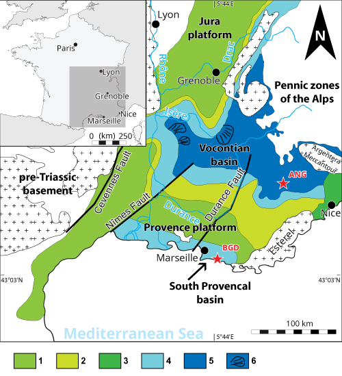
Figure 1: Map
of the sections studied in the context of the Vocontian Basin, the Provence
Platform and the South Provençal Basin; BGD=le Brigadan section near Cassis-La
Bédoule; ANG=the Angles Barremian stratotype section. Caption: 1) inner shelf
bioclastic facies; 2) outer shelf facies; 3) outer shelf, glauconitic (condensed
facies); 4) hemipelagic facies (slope); 5) pelagic facies (basin); 6) gravity
flow deposits. |
On
June 16th, 2025, on the invitation of Bruno Granier, we conducted a
reconnaissance survey on a large parcel of land, labelled AN0103 (Fig.
2 ![]() ). On August 13th, 2025, some more investigations were made.
). On August 13th, 2025, some more investigations were made.
One
aim of this paper is to evaluate the feasibility and suitability of proposing
this site as a candidate for the Aptian GSSP (near the Brigadan allotment: BGD
in Fig.
1 ![]() ), in light of the recent restrictions affecting the neighboring
historical quarries.
), in light of the recent restrictions affecting the neighboring
historical quarries.
At
the same time, it was interesting to search for a complete section around the
Barremian/Aptian boundary in the well-known sector of the Barremian stratotype
of Angles, in a pelagic and therefore complementary paleogeographic context. Investigations
therefore took place at the Angles road and in its immediate surroundings (ANG
in Fig.
1 ![]() ).
).
It is noteworthy that both sites, in addition to satisfying the established scientific criteria (see Hedberg et al., 1976; Cowie et al., 1986; Salvador, ed., 1994; Remane et al., 1996; Granier, 2025), also fulfill all supplementary requirements and recommendations of the International Commission on Stratigraphy (ICS), including those related to historic stability, uniqueness, accessibility, and protection - criteria that are not fully met by some other Aptian GSSP candidate sections.
|
|
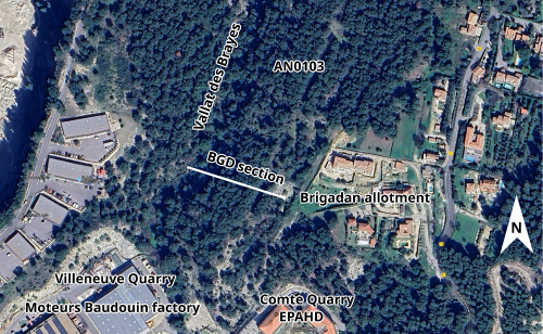
Figure 2:
Closeup of the locality of the Brigadan section (here BGD), in the vicinity of
the Villeneuve and Comte quarries. The Valla des Brayes is the local
toponymy for the Vallon Comte (in lit.). |
The lower Aptian outcrops around Cassis-Roquefort-La Bédoule belong to the Carpiagne anticline, of which they constitute the southern flank. They are in normal contact with the underlying Urgonian Formation, which constitutes the synclinal core, but are intersected by numerous small faults throughout the sector. In the historic 'Vallon Comte' (in lit. - here Vallat des Brayes according to the local toponymy), the lower Aptian layers are oriented towards the SE with a slight dip (10°). The studied area is framed by two of these faults, overall oriented E-W and perpendicular to the orientation of the strata. The northern fault exhibits strike-slip displacement relative to the Urgonian Formation.
On the 1:50,000 geological map of Aubagne-Marseille (Guieu et al., 1969), this area includes both the Urgonian Formation (n4U, 'Barrémien ŕ facičs Urgonien', an internal platform facies) and its hemipelagic uppermost Barremian–lower Aptian cover, the Bédoule Formation (n5) consisting of limestones, argillaceous limestones and marls.
Paleogeographically (Fig.
1 ![]() ), this area corresponds to the South Provençal Basin, bordered to the
south by the South Provençal Urgonian platform (which outcrops near Toulon),
and to the north by the North Provençal Urgonian platform (Monts de Vaucluse
- Ventoux). This basin is separated from the Vocontian Basin, to the
north-east, by the Verdon sill. The
Vocontian Basin is a large subsident intracratonic area characterized by
pelagic sedimentation deposited during the Mesozoic Era at the extreme
northwestern Tethys (Alpine Ocean).
), this area corresponds to the South Provençal Basin, bordered to the
south by the South Provençal Urgonian platform (which outcrops near Toulon),
and to the north by the North Provençal Urgonian platform (Monts de Vaucluse
- Ventoux). This basin is separated from the Vocontian Basin, to the
north-east, by the Verdon sill. The
Vocontian Basin is a large subsident intracratonic area characterized by
pelagic sedimentation deposited during the Mesozoic Era at the extreme
northwestern Tethys (Alpine Ocean).
From a paleoecological point of view, in the Cassis-Roquefort-La Bédoule area, the Urgonian Formation is overlain by a more siliciclastic calcareous series of topmost Barremian and basal Aptian. The faunas show an opening of the environment (cephalopods, mainly ammonites, absent from the Urgonian Formation), but remain predominantly neritic, with benthic forms being common (mollusca). This opening is confirmed from the Deshayesites forbesi Zone, manifested in the field by a very marked change in lithology to the deposition of marls.
Since the 1998 volume, the works of Lorenzen et al. (2013), and Moullade et al. (2015), have provided new elements on the carbon and oxygen cycles of this area, based on a borehole, mainly carried out as part of research on Oceanic Anoxic Event 1a (OAE1a). Borehole LB1 was drilled in the Fourniers area, at a place called 'Le Camping' and was correlated bed-by-bed with the reference section of the Cassis Station (see Moullade et al., 1998). It is, however, interesting to note the richness of the bioturbation, and the presence of glauconite, pyrite, micas, quartz and sponges (spicules) over the entire borehole, as well as the progressive aspect of the transitions between more calcareous and more marly beds, which sometimes mimic our own difficulties in the field in clearly delimiting certain bed limits (point 4). It is also necessary to note the apparent continuity of sedimentation over the entire borehole, with a minimum of diagenetic disturbances.
Stein et al. (2012) also conducted a geochemical study where they analysed the entire Cassis-Roquefort-La Bédoule section for the stable carbon isotope composition of organic carbon, as well as for its phosphorus (P), redox-sensitive trace elements (RSTE), and clay-mineral contents in order to explore changes in palaeoenvironmental conditions leading to OAE 1a. The evolution of kaolinite rate reveals the environment shifts from proximal (Barremian) to hemipelagic (lower Aptian). Based on the work of Stein et al. (2012), the section of Cassis-Roquefort-La Bédoule is of particular interest for several reasons: (1) it documents the drowning of Urgonian-type platform during the uppermost Barremian; (2) several laminated and organic-rich layers of uppermost Barremian age occur immediately on the top of the drowning unconformity (Masse & Machhour, 1998); and (3) the sedimentary interval containing the negative d13C excursion is expanded, compared to that of other sections.
As for the sections of the Vocontian Basin (area of the Barremian stratotype of Angles), they present a relatively homogeneous and continuous rhythmic sedimentation of alternating limestone beds and marl interbeds between the terminal Barremian and the basal Aptian, before the deposition of all the marlstone-dominated series. Useful comparisons can be made between the two areas.
In the search for a suitable place to define an Aptian GSSP, it is necessary to find a section where topmost Barremian and beds displaying the onset of the Deshayesites genus, which is considered the basic marker of the Aptian stage (Rawson, 1983; see Cecca et al., 1999, and literature), are present.
Authors from the 1990s agreed to recognize 3 distinct faunal intervals above the Urgonian at Cassis-Roquefort-La Bédoule: (1) a Heteroceratidae-bearing interval at the base (with Martelites and Micrancyloceras breve), (2) a Pseudocrioceras-bearing interval, and then (3) a more developed Deshayesites-bearing interval marking the beginning of the Aptian. However, the authors did not agree on the distribution of the genus Pseudocrioceras. According to Busnardo (1984), the distribution of this genus postdates the FAD of the Deshayesitidae ('Prodeshayesites'). For Delanoy et al. (1997), Pseudocrioceras appears before Deshayesites, but would disappear when the latter genus is already well expressed in the faunas. Finally, Ropolo et al. (1998) and Gonnet et al. (1998), maintained that Pseudocrioceras disappears before the appearance of Deshayesitidae without their distributions overlapping. Following Delanoy et al. (1997), it appears that due to significant morphological convergence, citations of 'Prodeshayesites' in the literature must be actually Martelites, while more recent work (see Ropolo et al., 2006) settled the question by showing that Pseudocrioceras is always older than Deshayesites and that their distributions do not overlap.
It is established that the historical stratotype of the Bedoulian is located at the Cassis railway station (Masse et al., 1998), and that the stratotype zone extends into the surrounding area of Roquefort-La Bédoule and Cassis. The immediate surroundings of Roquefort-La Bédoule no longer present any outcrops exposing the Barremian/Aptian boundary, with the exception of the highway section, which is difficult to access. Conte (1994) located the Bedoulian stratotype in the former Comte Quarry, while Ropolo et al. (1998) located it in the former Villeneuve quarry, these two old quarries being almost adjacent. For Gonnet et al. (1998), the stratotype is located at the Cassis railway station. In reality, the area studied in the past by Roch (1927) and referred to as 'historical', corresponds to a fairly large sector including the old Comte and Villeneuve quarries, and the Vallat des Brayes (Moullade et al., 1980, 1998): this is the whole area that corresponds to the so-called 'Gare de Cassis' outcrops reported by 20th century authors. Fabre-Taxy (1963) described this area in detail and created a cross-section of all the formations she recognized there. Simultaneously, Humbert (1963) emphasized the variations in facies between the outcrops. The site of the Cassis cemetery, where the Heteroceratidae level was reported, is now very urbanized and no longer allows any observations.
The Vallat des Brayes (3 sections between the railway station and the Sardons) subsequently appeared to have the most stable and complete lithological succession (Humbert, 1963, Fig. 2) and would correspond to a zone with extremely localized subsidence compared to the other sections of this area (Blanc, 1960). As previous authors did, we can clearly recognize the separation into two distinct lithologies (limestone at the base, marlier at the top), the Barremian-Aptian limit being confined to the lower and more calcareous zone. It appears that the section known as the historical Bedoulian stratotype corresponds to a composite section between all these outcrops (Moullade et al., 1998). This observation is shared by Stein et al. (2012), who also reported the difficulty of accessing certain parts of the synthetic section due to vegetation, and the difficulties of correlations between the sections. A detailed history of studies in this sector is given by Flandrin (1965) in the 1963 Lower Cretaceous conference, then again by Moullade et al. (1998).
Concerning the designation of a GSSP, Cecca et al. (1999) had proposed that the Bedoulian stratotype area be considered as a reference for the Barremian/Aptian boundary, but without designating a type section. Only the Brigadan section was described in their work (right side of the Vallat des Brayes, already cited by Cecca et al., 1998, then again by Ropolo et al., 1999), with the stage boundary precisely positioned between beds 81 and 82 (appearance of the first Deshayesites in bed 82). It would therefore be legitimate to consider this section as a potential GSSP candidate. This outcrop was found by us, although it was poorly located by these authors (e.g., Cecca et al., 1999, Fig. 2, point 1), in an area where only the Urgonian outcrops. It is now completely covered by forest and can no longer be studied. This section clearly corresponded to a few beds that were difficult to delineate and measure due to their shallow dip (Cecca et al., 1999, p. 268). This difficulty, as well as the different numbering of the beds from that used on the composite stratotype section, make correlations difficult. It appears that this site cannot therefore be validly considered for designation as a GSSP. More recently, a Bedoulian GSSP (as an independent stage) was proposed by Moullade et al. (2011), in the Villeneuve quarry at the base of bed 60 of the stratotype terminology. Its access and study are now made very complicated by the presence of the Moteurs Baudouin Company, and this choice can no longer be retained today.
Other sections have been described on the right side of the Vallat des Brayes. Delanoy et al. (1997, Fig. 2) described a log named 'les Sardons section': in this section, the authors placed the Barremian/Aptian boundary between beds 80 and 81 (appearance of the first Deshayesites in bed 81). Here again, the numbering is not that of the stratotype terminology, and the lithology does not resemble the sections figured by the other authors. This section was redescribed by Gonnet et al. (1998), then Ropolo et al. (1999) under the name 'les Caniers section', but the lithology and the distribution of the faunas are again not the same. Moullade et al. (1998, p. 19 and Fig. 3), in their article describing the lithology of the sections in the Cassis-La Bédoule sector, proposed a reference horizon of black shales supposed to represent the Barremian/Aptian boundary in the Cassis-La Bédoule area: the Roch Horizon. In the synthetic stratotype log (op.cit., Fig. 3), this horizon is located between beds 59 and 60. In the same work, the authors discussed the section 'les Sardons (les Caniers)' (op.cit., p. 27, Fig. 10): the Roch Horizon is expressly reported and identified there; it is also located between beds 59 and 60. However, the lithology/numbering of this section differs clearly from those named 'les Sardons' and/or 'les Caniers' figured by Delanoy et al. (1997, Fig. 2) then Ropolo et al. (1998, Fig. 1). Moullade et al. (1998) positioned the Roch Horizon in the 'les Caniers' section of Ropolo et al. (1998, Fig. 1) '1.5 m above bed 81', which would make it correspond to a marl level located between beds 86 and 87, high above the Barremian/Aptian boundary recognized by these authors. Later, Frau and Delanoy (2022, Fig. 3) redescribed the 'les Sardons section' of Delanoy et al. (1997, Fig. 2) by naming it 'les Sardons (= les Caniers)'. These authors cited and included numerous fossils from sites sometimes named 'les Sardons/les Caniers', sometimes 'les Caniers/les Sardons', which adds to the confusion surrounding these localities. The location of these sections, given by the authors, corresponds to an area where the Urgonian outcrops and the site has not yet been found by us; new research will be conducted in this sector over a wider area to identify this locality.
We have to wait for the work of Ropolo et al. (2006, Figs. 7-8), to see the faunas of the different sections replaced in relation to the synthetic stratotype log of Moullade et al. (1998) with the corresponding bed numbers. It is however important to point out that most of the ammonites collected and reported in works during 1990-2010 (all authors combined) do not come from the sections used to produce the synthetic stratotype log, but from sections outcropping in poor conditions, that are provisional (depending on construction works), or sampled in conditions which do not correspond to current scientific standards (approximate collections by amateurs). One may wonder how the correlations proposed at the bed level were carried out, given that the log-surveys of the addenda sections (Caniers/Sardon, Brigadan, Fournier, Camerlots) are dissimilar from the synthetic reference log, and that the precise location at the bed level of the specimens collected sometimes appears to be unreliable. This is the case, for example, of the specimen shown by Ropolo et al. (1999, Pl. 5, fig. 1), and identified as Pseudocrioceras orbignyanum, reported in bed 80 of the Camerlots section (sic). This specimen actually comes from the old Marcouline quarry, in much more recent levels, as indicated by R. Gonnet to one of us (DB, oral communication of the 07/03/2012), to whom this specimen belonged, and who told us the conditions of collection of this specimen (and others) by Francis Gondran. This specimen must be reassigned to Ammonitoceras (morphology Epancyloceras, see Bersac & Bert, 2022). To our knowledge, the specimens from private collections studied by the authors of the 1990's-2000's have for the most part not been deposited in public institutions, and are largely no longer accessible to the scientific community.
More recently, Frau and Delanoy (2022) proposed the revision of several ammonite species around the Barremian/Aptian boundary of the Cassis-La Bédoule area. Their stratigraphic distribution is given, essentially from samples taken by R. Busnardo in the 1980's and since deposited at the University of Lyon 1. They described again the synthetic stratotype section based on the work of Stein et al. (2012) and in turn proposed correlations between the different sections of the literature (Cassis station, Brigadan, Caniers, Sardons) also noting the difficulties due to imprecise logs and faunal distributions that could be problematic (e.g., 'idealised' in Ropolo et al., 2006). Moreno-Bedmar et al. (2009, 2010) also recognized those discrepancies concerning taxonomy and sample control, which pose some problems to correlate the age of the OAE1a event between the Iberian Chain and the Cassis-La Bédoule areas.
To summarize, in the literature there is currently no section of the Barremian/lower Aptian limestone series that is not either synthetic or partial, and sampled with the standards that one would expect in the context of the study of a GSSP. New field research is therefore necessary, on the one hand to find a non-composite section that is as complete as possible around the Barremian/Aptian boundary, and that can be easily sampled (ideally not on a quarry face) to allow precise location of future samples.
Urgonian strata, which form a structural surface on the western slope of the valley ('rive droite'), are also visible at its deepest part. The area of interest in the Vallat des Brayes is the 'Limestone Member' of the lower Aptian. The Barremian/Aptian boundary is located in the La Bédoule Formation, which starts several meters above the last rudist levels of the Urgonian Formation (bed 36 of the type section in Moullade et al., 1998).
Along the eastern flank of the valley - for example, at GPS coordinates 43°14'28.4"N, 5°33'35.8"E - a succession of supra-Urgonian beds can be observed, standing out more or less clearly in the topography. Several extensive old excavations are visible, in several levels. The sequence continues upward with thinly bedded limestones, which form a structural surface within the forest (at GPS coordinates 43°14'23.7"N, 5°33'35.4"E). Above this level, just below the first houses of the Brigadan residential area, a few more additional beds are exposed.
At GPS
coordinates 43°14'22.7"N, 5°33'31.1"E, we logged a section of
supra-Urgonian beds forming a small cliff (Fig. 3 ![]() ). This section, here
designated 13022-BGD, shows traces of old, now illegible numbering on several
beds. The beds follow each other easily in the upper part
of the section. In the
lower part, the outcrop includes some zones of poor visibility, which could be
cleaned later. In
particular below the old excavation residues mask the lowest layers. It will be necessary either to remove the debris
or to clear the hidden layers on the side. The
bottom of the talweg at this point is also completely vegetated and we cannot
see the limit with the Urgonian. On
the other hand, a little further north, we see that the Urgonian is probably
uplifted and exposed by a north/south fault which cuts across the valley
because it forms a step of approximately 3 m height. The first levels here are still Urgonian with
bivalves and rudists; the
section continues above the Urgonian for more than several meters in height.
). This section, here
designated 13022-BGD, shows traces of old, now illegible numbering on several
beds. The beds follow each other easily in the upper part
of the section. In the
lower part, the outcrop includes some zones of poor visibility, which could be
cleaned later. In
particular below the old excavation residues mask the lowest layers. It will be necessary either to remove the debris
or to clear the hidden layers on the side. The
bottom of the talweg at this point is also completely vegetated and we cannot
see the limit with the Urgonian. On
the other hand, a little further north, we see that the Urgonian is probably
uplifted and exposed by a north/south fault which cuts across the valley
because it forms a step of approximately 3 m height. The first levels here are still Urgonian with
bivalves and rudists; the
section continues above the Urgonian for more than several meters in height.
|
|
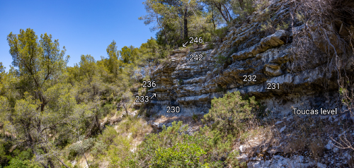
Figure 3: The
current aspect of the cliff of the section BGD (see Fig. 2 |
Throughout the section, fossils are rare on the ground,
but it was possible to observe Pseudocrioceras
sp. (not in situ) in the lower part, followed closely above by
Deshayesites sp. The
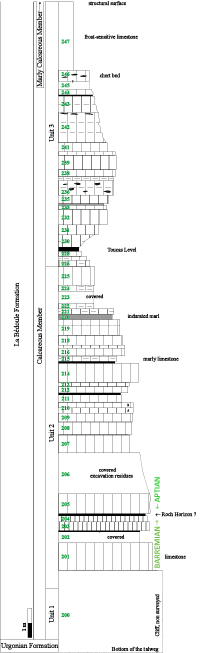
bed numbers in the log (Fig. 4 ![]() ) are provisional and will need to be revised
once the obscured areas have been cleaned.
) are provisional and will need to be revised
once the obscured areas have been cleaned.
We can compare our provisional survey-log (Fig.
4 ![]() ) with the synthetic reference section. At this point, there remain differences in
interpretation due to the particular lithology of the naturally eroded beds,
and for which it is sometimes difficult to correctly place the limit compared
to the reference log, which was taken largely on quarry working faces where
the beds and interbeds do not have the same appearance as at the outcrop. The main marl level, which forms the most visual
clue in the middle of the slope (our level 229-230; Fig. 3
) with the synthetic reference section. At this point, there remain differences in
interpretation due to the particular lithology of the naturally eroded beds,
and for which it is sometimes difficult to correctly place the limit compared
to the reference log, which was taken largely on quarry working faces where
the beds and interbeds do not have the same appearance as at the outcrop. The main marl level, which forms the most visual
clue in the middle of the slope (our level 229-230; Fig. 3 ![]() ) corresponds to the
Toucas Horizon (bed 106 of the reference section; not visible in the
Fabre-Taxy log-section of 1963, between meters 30-35). The upper part can easily be correlated to bed
128, which represents the structural surface in the forest in section
13022-BGD (top of our bed 247. It
is at meter 42 on the Fabre-Taxy log-section). The
lower part, at the marker formed by the Toucas Horizon, is also largely
correlatable up to our bed 225 (=104). Further
down, the presence of covered sections does not allow us for the moment to be
more precise. In particular, we are currently unable to precisely locate the Barremian/Aptian
boundary due to an insufficient number of surface-collected ammonites, but it
could likely lie within the interval spanning beds 205-207. The marl level at
204-204 could possibly correspond to the Roch Horizon. Future work is required to remove these
uncertainties.
) corresponds to the
Toucas Horizon (bed 106 of the reference section; not visible in the
Fabre-Taxy log-section of 1963, between meters 30-35). The upper part can easily be correlated to bed
128, which represents the structural surface in the forest in section
13022-BGD (top of our bed 247. It
is at meter 42 on the Fabre-Taxy log-section). The
lower part, at the marker formed by the Toucas Horizon, is also largely
correlatable up to our bed 225 (=104). Further
down, the presence of covered sections does not allow us for the moment to be
more precise. In particular, we are currently unable to precisely locate the Barremian/Aptian
boundary due to an insufficient number of surface-collected ammonites, but it
could likely lie within the interval spanning beds 205-207. The marl level at
204-204 could possibly correspond to the Roch Horizon. Future work is required to remove these
uncertainties.
From these initial observations, it appears that this section is probably one of the last that can be studied (i.e., contiguous, and capable of being surveyed and sampled) in the sector of the historical Bedoulian stratotype. Although it is partly covered by debris in its lower part, future field campaigns should be able to make a complete log of the limestone member of the Bédoule Formation that contains the Barremian/Aptian boundary, in order to propose a GSSP. It has the advantage of being on a parcel of communal land, which, in collaboration with the Town Hall of Cassis, should facilitate its long-term preservation, both against urbanization and illegal excavations conducted by amateurs.
|
|
Figure 4: The
log-section BGD. Bed numbers are provisional, pending new log-survey with cover
removed. |
At Cassis-La Bédoule, the genus Deshayesites
immediately and abundantly follows, to the precise bed, the genus Pseudocrioceras,
which marks a very clear and distinct boundary between the Barremian and
Aptian stages. This
succession, however, appears to be very abrupt and should be confirmed by
observations in a pelagic area with sedimentation known to be regular and
continuous. The
area of the Barremian stratotype of Angles (ANG in Fig.
1 ![]() ) is now well known
and was chosen because of the numerous studies that have already taken place
there.
) is now well known
and was chosen because of the numerous studies that have already taken place
there.
According to the literature concerning the biostratigraphy of the Barremian/Aptian boundary of the southern Vocontian area, we note that:
the genus Pseudocrioceras is reputed to be absent, or too rare for correlations to be made with the Cassis area (notable exception in Delanoy, 1997, p. 242, in the Descoučre section), and other regions of the world where this genus is present (Colombia, Caucasus, etc.);
according the work of Delanoy (1997), the ammonites become considerably rarer upwards the upper part of the Sarasini Zone (see also Janssen et al., 2012, p. 207);
according to Cecca et al. (1998), the ammonite succession would be less complete stratigraphically than at Cassis-Roquefort-La Bédoule (op.cit., p. 280; Cecca et al., 1999, p. 280-284). This observation, not explained by those authors, is most likely related to the presence of a fault in the basal Aptian along the reference section of the Angles road, between beds 216 and 220 (Janssen et al., 2012, p. 205).
Further to the first point, a work in progress (Bert et al., in preparation) shows that the genus Pseudocrioceras, with the first occurrence of the genus Kutatissites, is indeed present in the area of the Barremian stratotype of Angles, in a well-defined stratigraphic unit between the Martelites and Deshayesites levels. This suggests very precise correlations between the historical Bedoulian and Barremian stratotypes are possible.
The second point must also be qualified. Even if they are not always abundant, our field research always shows the presence of ammonites. This becomes even more obvious, as it is now possible to identify Deshayesites species on the basis of small specimens, provided that their ventral zone in the internal whorls is preserved (Bersac & Bert, 2012, 2015, 2025).
Finally, although the Barremian stratotype section along the Angles' road shows a clearly visible lithological succession, it is difficult to sample. The presence of a fault may have discouraged some authors from studying it in greater depth (Janssen et al., 2012, Pl. 24, fig. A). In the surrounding area, only a few sections have been described by Delanoy (1997) with the certain presence of the Barremian/Aptian boundary. These are at Méouilles, le Vignon, and possibly Grande-Terre. The Combe-Lambert section was described in 1965 by Busnardo as a complementary section to the roadside stratotype. It presents the whole lower Aptian limestone, but the boundary with the Barremian is not known (Delanoy, 1997, Fig. 129) due to cover. This section was recently revisited and exposed, which allowed observations upwards the base of the Giraudi Zone. The section, protected by the National Geological Nature Reserve of Haute-Provence, is currently under study and could be proposed as a complementary section to the GSSP of the Aptian.
The 'coupe du Brigadan' described by Cecca et al. (1998: Fig. 1) and Ropolo et al. (1998: Fig. 4), located 500 m north of the Villeneuve quarry, is only 6 meters thick and begins at a fault. In contrast, our Brigadan section (13022-BGD), situated just 100 m north of the Villeneuve quarry, is more developed and has a greater measured thickness, making it a strong candidate for the Aptian GSSP.
Parcel AN0103 is owned by the municipality of Cassis (Bouches-du-Rhône). According to the PLUI (Local Intercommunal Urban Plan), it is predominantly classified as zone A1 (agricultural zone), with a portion designated as zone Ns (natural zone). Numerous traces of excavation are visible across the site, some of which are fairly extensive. While most appear to be old - likely related to earlier geological work - others are clearly more recent. Several of these excavations affect multiple stratigraphic levels. A procedure to protect and preserve the entire site, in accordance with the requirements of the ICS (International Commission on Stratigraphy; Cowie et al., 1986; Remane et al., 1996; Granier, 2025), is currently underway.
The Combe-Lambert section, in the immediate vicinity of the Barremian stratotype of the Angles road (Alpes-de-Haute-Provence), now presents a large part of the upper Barremian and the whole lower Aptian limestone. This follows recent fieldwork, which removed cover that obscured its base. Study of this section is in progress, and its location in a protected area (National Geological Nature Reserve of Haute-Provence) should allow it to be considered as an auxiliary candidate to the Aptian GSSP.
We thank Madame Danielle Millon, Mayor of Cassis (Bouches-du-Rhône), as well as the deputy mayors and municipal staff (M. Feraud, B. Muylle, and D. Zamour) for granting us permission to conduct fieldwork on communal property. We also extend our gratitude to Dr. Thierry Tortosa (Marseille) for facilitating this project, as well as to Alexandre Assemat, Emmanuel Faure (RNNGHP), and Bernard Beltran (GPA) for their help in the field at Angles (Alpes-de-Haute-Provence). We warmly thank Josep Anton Moreno-Bedmar (Universidad Nacional Autónoma de México, Ciudad de México), Mathieu Martinez (Université de Rennes 1), and Antoine Pictet (Muséum cantonal des sciences naturelles, Lausanne) for their thorough reviews that improved the manuscript. We are grateful to Phil Salvador for a linguistic correction of the manuscript.
Bersac S. & Bert D. (2012).- Ontogenesis, variability and evolution of the Lower Greensand Deshayesitidae (Ammonoidea, Lower Cretaceous, Southern England): Reinterpretation of literature data; taxonomic and biostratigraphic implications.- Annales du Muséum d'Histoire Naturelle de Nice, tome XXVII, p. 197-270.
Bersac S. & Bert D. (2015).- Two ammonite species under the same name: Revision of Deshayesites deshayesi (d'Orbigny, 1841) based on topotype material (Lower Aptian, Lower Cretaceous, Northeast of France).- Annales de Paléontologie, vol. 101, no. 4, p. 265-294.
Bersac S. & Bert D. (2022).- The heteromorph ammonite genus Ammonitoceras Dumas, 1876 (Ancyloceratidae) in the lower Aptian (Lower Cretaceous) of the Les Ferres Aptian Basin (southeastern France).- Annales de Paléontologie, vol. 108, no. 3, article 102570, 20 p.
Bersac S. & Bert D. (2025).- The Deshayesitidae (Ammonoidea, Ancyloceratina) in the lower Aptian (Lower Cretaceous) of the Les Ferres Aptian Basin (southeastern France).- Carnets Geol., Madrid, vol. 25, no. 9, p. 177-200. DOI: 10.2110/carnets.2025.2509
Blanc J.-J. (1960).- Les facičs de l'Aptien dans la région de Marseille.- Bulletin du Muséum d'Histoire Naturelle de Marseille, vol. XX, p. 61-68.
Busnardo R. (1965).- Le stratotype du Barrémien. Lithologie et macrofaune. In: Colloque sur le Crétacé inférieur (Lyon, septembre 1963).- Mémoires du Bureau de Recherches Géologiques et Miničres, Orléans, no. 34, p. 101-116.
Busnardo R. (1984).- Ammonites. In: Chapitre Crétacé inférieur - Synthčse géologique du Sud-Est de la France.- Mémoires du Bureau de Recherches Géologiques et Miničres, Orléans, no. 125, p. 292-294.
Cecca F., Ropolo P. & Gonnet R. (1998).- La base de l'Aptien ŕ Cassis-La Bédoule (SE France).- Géologie Méditerranéenne, Marseille, t. XXV, nos. 3-4, p. 149-157.
Cecca F., Ropolo P. & Gonnet R. (1999).- The appearance of the genus Deshayesites (Kazansky, 1914, Ammonoidea) in the lowermost Aptian (Lower Cretaceous) of la Bédoule (SE France). Rivista Italiana di Paleontologia e Stratigrafia, vol. 105, no. 2, p. 267-286.
Conte G. (1994).- La limite Bédoulien-Gargasien dans la coupe stratotypique de Cassis-La Bédoule (Bouches-du-Rhône, France).- Géologie Alpine, Grenoble, Mémoire Hors Série, no. 20, p. 321-326.
Cowie J.W., Ziefler W., Boucot A.J., Bassett M.G. & Remane J. (1986).- Guidelines and statutes of the International Commission on Stratigraphy (ICS).- Courier Forschungsinstitut Senckenberg, vol. 83, p. 1–14.
Delanoy G. (1997).- Biostratigraphie des faunes d'ammonites ŕ la limite Barrémien-Aptien dans la région d'Angles-Barręme-Castellane.- Annales du Muséum d'Histoire Naturelle de Nice, t. XII, 269 p.
Delanoy G., Busnardo R., Ropolo P., Gonnet R., Conte G., Moullade M. & Masse J.-P. (1997).- The 'Pseudocrioceras beds' at La Bédoule (SE France) and the position of the Barremian-Aptian boundary in the historical lower Aptian stratotype.- Comptes rendus de l'Académie des Sciences (Sciences de la Terre et des Plančtes), Paris, vol. 325, p. 593-599.
Fabre-Taxy S., Moullade M. & Thomel G. (1965).- Le Bédoulien dans sa région type, La Bédoule-Cassis (B.-du-R.). In: Colloque sur le Crétacé inférieur (Lyon, septembre 1963).- Mémoires du Bureau de Recherches Géologiques et Miničres, Orléans, no. 34, p. 173-199.
Flandrin J. (1965).- Rapport sur l'étage Aptien. In: Colloque sur le Crétacé inférieur (Lyon, septembre 1963).- Mémoires du Bureau de Recherches Géologiques et Miničres, Orléans, no. 34, p. 227-234.
Frau C. & Delanoy G. (2022).- Taxonomic notes on some Barremian-Aptian cephalopods from the Station de Cassis section and surrounding sites, Bouches-du-Rhône, southern France.- STRATA (série 2e), Gaillac, vol. 58, p. 1-45.
Gonnet R., Ropolo P. & Conte G. (1998).- Les Deshayesites de la zone ŕ D. tuarkyricus dans l'Aptien inférieur de Cassis-La Bédoule (SE France).- Géologie Méditerranéenne, Marseille, t. XXV, nos. 3-4, p. 125-147.
Granier B.R.C. (2025).- Elusive Golden Spikes: When stratigraphers face the technical impossibility of specifying a GSSP in the field.- Carnets Geol., Madrid, vol. 26, no. 1, p. 1-16. DOI: 10.2110/carnets.2026.2601
Guieu G. (coord.), Blanc J.-J., Bonifay E., Caron J.-P.-H., Gouvernet C., Nury D., Philip J., Taxy-Fabre S. & Tempier C. (1969).- Aubagne-Marseille.- Carte géologique au 1:50 000, notice, Orléans-La Source, XXXI-XXXII-45, 2e édition, 26 p.
Hedberg H.D. (ed., 1976).- International stratigraphic guide. A guide to stratigraphic classification, terminology and procedure.- John Wiley and Sons, New York, 200 p.
Humbert S. (1963).- Contribution ŕ l'étude du Bédoulien entre La Bédoule et Cassis (Bouches-du-Rhône).- Bulletin de la Société géologique de France (7e série), Paris, t. V, no. 6, p. 953-958.
Janssen N.M.M., Clément A. & Bont W. (2012).- Mediterranean Neocomian belemnites, part 4: Belemnites of the Barremian stratotype section.- Carnets Geol., Madrid, vol. 12, no. M02 (CG2012_M02), p. 201-274. DOI: 10.4267/2042/48307
Lorenzen J., Kuhnt W., Holbourn A., Flögel S., Moullade M. & Tronchetti G. (2013).- A new sediment core from the Bedoulian (Lower Aptian) stratotype at Roquefort-La Bédoule, SE France.- Cretaceous Research, vol. 39, 6-16.
Masse J.-P. & Machhour L. (1998).- La matičre organique dans la série du stratotype historique de l'Aptien inférieur dans la région de Cassis-La Bédoule (SE France).- Géologie Méditerranéenne, Marseille, t. XXV, nos. 3-4, p. 55-62.
Masse J.-P., Moullade M. & Tronchetti G. (1998).- Cadre régional du stratotype historique de l'Aptien inférieur dans la région de Cassis-La Bédoule (SE France).- Géologie Méditerranéenne, Marseille, t. XXV, nos. 3-4, p. 11-14.
Moreno-Bedmar J.A., Company M., Bover-Arnal T., Salas R., Delanoy G., Martinez R. & Grauges A. (2009).- Biostratigraphic characterization by means of ammonoids of the lower Aptian Oceanic Anoxic Event (OAE 1a) in the eastern Iberian Chain (Maestrat Basin, eastern Spain).- Cretaceous Research, vol. 30, p. 864-872.
Moreno-Bedmar J.A., Company M., Bover-Arnal T., Salas R., Delanoy G., Maurrasse F.J., Grauges A. & Martinez R. (2010).- Lower Aptian ammonite biostratigraphy in the Maestrat Basin (Eastern Iberian Chain, Eastern Spain). A Tethyan transgressive record enhanced by synrift subsidence.- Geologica Acta, Barcelona, vol. 8, no. 3, p. 1-19.
Moullade M., Granier B. & Tronchetti G. (2011).- The Aptian Stage : Back to fundamentals.- Episodes, Bangalore, vol. 34, no. 3, p. 148-156.
Moullade M., Taxy S. & Tronchetti G. (1980).- Bédoulien. In: Cavelier C. & Roger J. (eds.), Les étages français et leurs stratotypes.- Mémoires du Bureau de Recherches Géologiques et Miničres, Orléans, no. 109, p. 116-119.
Moullade M., Tronchetti G. & Masse J.-P. (eds., 1998).- Le stratotype historique de l'Aptien inférieur (Bédoulien) dans la région de Cassis-La Bédoule (S.E. France).- Géologie Méditerranéenne, Marseille, t. XXV, nos. 3-4, 298 p.
Moullade M., Tronchetti G., Busnardo R. & Masse J.-P. (1998).- Description lithologique des coupes-types du stratotype historique de l'Aptien inférieur dans la région de Cassis-La Bédoule (SE France).- Géologie Méditerranéenne, Marseille, t. XXV, nos. 3-4, p. 15-29.
Moullade M., Tronchetti G., Granier B., Bornemann A., Kuhnt W. & Lorenzen J. (2015).- High-resolution integrated stratigraphy of the OAE1a and enclosing strata from core drilling in the Bedoulian stratotype (Roquefort-La Bédoule, SE France).- Cretaceous Research, vol. 56, p. 119-140.
Rawson P. (1983).- The Valanginian to Aptian stage. Current definitions and outstanding problems.- Zitteliana, München, Band 10, p. 493-500.
Remane J., Bassett M.G., Cowie J.W., Gohrbandt K.H., Lane R.L., Michelsen O. & Wang N. (1996).- Revised guidelines for the establishment of global chronostratigraphic standards by the International Commission on Stratigraphy (ICS).- Episodes, Bangalore, vol. 19, no. 3, p. 77–81. DOI: 10.18814/epiiugs/1996/v19i3/007
Roch É. (1927).- Étude stratigraphique et paléontologique de l'Aptien inférieur de la Bédoule (prčs Cassis) (Bouches-du-Rhône).- Mémoires de la Société géologique de France (NS), Paris, no. 8, 37 p. (V Pls.).
Ropolo P., Conte G., Gonnet R., Masse J.-P. & Moullade M. (1998).- Les faunes d'ammonites du Barrémien supérieur/Aptien inférieur (Bédoulien) dans la région stratotypique de Cassis-La Bédoule (SE France) : État des connaissances et propositions pour une zonation par Ammonites du Bédoulien-type.- Géologie Méditerranéenne, Marseille, t. XXV, nos. 3-4, p. 167-175.
Ropolo P. Gonnet R. & Conte G. (1999).- The 'Pseudocrioceras interval' and adjacent beds at La Bédoule (SE France): Implications to highest Barremian/lowest Aptian biostratigraphy.- Scripta Geologica, Leiden, Special Issue, vol. 3, p. 159-213. URL: https://repository.naturalis.nl/pub/216201/SGSI03_159-214.pdf
Ropolo P., Moullade M., Gonnet R., Conte G. & Tronchetti G. (2006).- The Deshayesitidae Stoyanov, (1949 (Ammonoidea) of the Aptian historical stratotype region at Cassis-La Bédoule (SE France).- Carnets Geol., Madrid, vol. 6, no. M01 (CG2006_M01), p. 1-46. DOI: 10.4267/2042/4744
Salvador A. (ed., 1994).- International stratigraphic guide. A guide to stratigraphic classification, terminology and procedure, 2nd edition.- IUGS and the Geological Society of America, 214 p.
Stein M., Westermann S., Adatte T., Matera V., Fleitmann D., Spangenberg J.E. & Föllmi K. (2012).- Late Barremian-Early Aptian palaeoenvironmental change: The Cassis-La Bédoule section, southeast France.- Cretaceous Research, vol. 37, p. 209-222.
Toucas A. (1888).- Note sur le Jurassique supérieur et le Crétacé inférieur de la vallée du Rhône.- Bulletin de la Société géologique de France (3e Série), Paris, t. XVI, p. 903-927. URL: https://patrimoine.sorbonne-universite.fr/idurl/1/2709