◄ Carnets Geol. 26 (01)
![]()
Outline:
[1. Introduction]
[2. Wells and cores are unsuitable as boundary stratotypes]
[3. Field geologists should be able to identify the GSSP or SABS]
[4. Conclusions] and ...
[Bibliographic references]
Membre correspondant, Muséum d'histoire naturelle (MHN),
Route de Malagnou 1, 1208 Genève (Switzerland);
Association Carnets de Géologie, 2 impasse Charles Martel, F-29217 Plougonvelin (France)
[ORCID: 0000-0001-9468-2353]
Published online in final form (pdf) on December 1, 2025
DOI: 10.2110/carnets.2026.2601
![]()
[Editor: Michel Moullade; language editor: Phil Salvador; technical editor: Bruno
R.C. Granier]
![]()
This publication explores challenges in defining Global Boundary Stratotype Sections and Points (GSSPs) and Standard Auxiliary Boundary Stratotypes (SABSs). It identifies issues with recent practices that undermine the principles of uniqueness and accessibility fundamental to these boundaries. Examples include the controversial use of cores to designate GSSPs for the Quaternary Period, the disregard for essential geological requirements, the failure to ensure field accessibility, and the lack of protection for key sites. These concerns, exemplified by the Cenomanian GSSP for the Cretaceous Period, which remains unprotected after more than 20 years, highlight the need for stricter adherence to guidelines and a reevaluation of current practices, advocating for the mandatory enforcement of certain rules. Other examples discussed specifically relate to the author's personal experience with Lower Cretaceous GSSPs and SABSs.
• Global Boundary Stratotype Section and
Point;
• Standard Auxiliary Boundary Stratotype;
• Quaternary;
• Cretaceous;
• International Commission on Stratigraphy;
• recommendations;
• rules
Granier B.R.C. (2025).- Elusive Golden Spikes: When stratigraphers face the technical impossibility of specifying a GSSP in the field.- Carnets Geol., Madrid, vol. 26, no. 1, p. 1-16. DOI: 10.2110/carnets.2026.2601
Les clous d'or insaisissables : Quand les stratigraphes font face à l'impossibilité technique de définir un GSSP sur le terrain.- Cet article explore les défis liés à la définition des Sites et Points Stratotypiques Mondiaux (PSM) et des Sections Stratotypiques Auxiliaires Standards (SSAS). Il met en lumière les problèmes posés par certaines pratiques récentes, comme l'utilisation de carottes, qui compromettent les principes fondamentaux d'unicité et d'accessibilité propres à ces limites. Des exemples incluent l'utilisation controversée de carottes pour désigner les GSSP de la Période Quaternaire. L'article critique également le non-respect d'exigences géologiques essentielles, l'absence d'accessibilité sur le terrain et le manque de protection des sites clés. Ces préoccupations, illustrées par le cas du GSSP du Cénomanien pour le Crétacé, resté non protégé depuis plus de 20 ans, soulignent la nécessité d'une stricte adhésion aux directives, ainsi qu'une réévaluation des pratiques actuelles, en plaidant pour l'application obligatoire de certaines règles. Les autres exemples discutés dans le texte se rapportent spécifiquement à l'expérience personnelle de l'auteur avec des GSSP et SABS du Crétacé inférieur.
• Point stratotypique mondial ;
• Section Stratotypique Auxiliaire Standard ;
• Quaternaire ;
• Crétacé ;
• Commission Internationale de Stratigraphie ;
• recommandations ;
• règles
This publication is dedicated to the late Dr Amos Salvador (14/04/1923 02/12/2007), whose major contributions to the field of stratigraphy served as a guiding reference for the author during his early career as an oil and gas explorationist, and later as a university professor.
The geologic time scale is a human construct imposed upon the natural world. The direct correspondence between rock successions and time categories is neither precise nor entirely accurate. It is now accepted that each time-scale unit should be defined by its base, referenced to a specific stratigraphic section in which this lower boundary is characterized by distinctive biostratigraphic, lithostratigraphic, biomagnetostratigraphic, and/or biochemostratigraphic properties (see Granier et al., 2024, regarding the use of the prefix 'bio-').
By definition, a Global Boundary Stratotype Section and Point (GSSP) 'is essentially a unique and specific point in a specific sequence of sedimentary rock strata at a unique and specific geographical location' (Cowie et al., 1986). It serves as the reference point for defining the base of the corresponding stage on the International Chronostratigraphic Chart.
Rules for definition of GSSPs are listed on the ICS website (ICS-International Commission on Stratigraphy, https://stratigraphy.org/gssps/) and summarized here (Table 1).
Table 1. Summary of the ICS rules for defining chronostratigraphic boundary proposals (modified from https://stratigraphy.org/gssps/ as of 21/01/2025)
| 1. | MUST contain a stratigraphic marker; |
| 2. | MUST be observable, unambiguous change in the physical or fossil properties; |
| 3. | MUST be adequately thick for global correlation; |
| 4. | MUST be continuous without facies changes; |
| 5. | SHOULD be unaffected by other geological processes; |
| 6. | MUST be accessible to research; |
| 7. | Fossil content SHOULD be reproducible and widespread (i.e., abundant, distinctive, well preserved, and cosmopolitan); |
| 8. | SHOULD contain other marker horizons or attributes. |
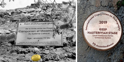
Remane's use of 'should' indicates that these guidelines are recommendations, not rules. The word 'must' appears six times, while 'should' appears seven times (Remane et al., 1996). However, it is suggested here that these guidelines ought to be mandatory rather than remaining optional.
Additionally, Remane et al. (1996) stated that the International Commission on
Stratigraphy (ICS) 'should attempt to finalize, within three years after the
International Union of Geological Sciences (IUGS) ratification, any remaining
official steps for the protection of the site with the authorities of the
country in which the GSSP is located'. Furthermore, the point 'should be
indicated by a permanently fixed marker' (Remane et al.,
1996), commonly
represented in
the field by a 'Golden Spike' in the form of a large nail made of brass (Fig.
1.A-B ![]() ).
).
Unfortunately, enforcing such rules is not always effective. For example, the Cenomanian GSSP (Kennedy et al., 2004) at Mont Risou (Hautes-Alpes, SE France) remains unprotected more than 20 years after its ratification because the Cenomanian Working Group was unable to secure the site. This GSSP faces more than just this issue, as will be demonstrated in this paper. Except for the Quaternary Period and the Cenomanian, the examples discussed primarily come from the Lower Cretaceous, for which the author has direct personal field experience.
Moreover, some other aspects of the ICS Guidelines require clarification to avoid ambiguity. For instance, it should be clearly stated that designating a GSSP or its Standard Auxiliary Boundary Stratotype (SABS) based on a subsurface core interval is incompatible with both the uniqueness of the point at its geographical location [*] and the accessibility to the site (which is necessarily located at some depth in the subsurface). In fact, such an option (well location and core material) is inadequate and common sense suggests that it must be rejected.
Finally, because some currently ratified GSSPs do not meet all of the requirements, the author recommends that certain GSSPs should be reevaluted to determine whether any should be revised or replaced.
|
|
Figure 1: A) The Golden Spike (of the base) of the
Maastrichtian at Tercis-les-Bains (Odin & Lamaurelle,
2001),
Les Landes (SW France). Photo courtesy of Gilles Serge Odin; B) The Golden Spike
(of the base) of the Hauterivian at La Charce (Mutterlose et al.,
2021), La Drôme (SE France). Photo courtesy of Stéphane Reboulet
(30/08/2024). |
Members of the Aptian Working Group of the International Subcommission on Cretaceous Stratigraphy (ISCS), including the author, recently commented on a candidate section for its GSSP or its SABS based on core from the APTICORE Cismon well (Erba et al., 1999). The chief reason for using this core was the existence of precedents of cores used by other GSSPs, namely (the bases of) the Northgrippian Stage (Walker et al., 2018) and the Greenlandian Stage (Walker et al., 2018). Nevertheless, there are several other important reasons to argue against the appropriateness of the selection of this core as a candidate (e.g., its estimated rate of 'compacted' sedimentation at the critical interval is less than 3.5 mm/ka, which is an ultracondensed section),
A core is a
cylindrical piece of rock taken from the subsurface by a special drill bit and
brought to the surface for examination. Accordingly, a core taken from
sedimentary rocks is merely a continuous sampling of a given interval. When on
May 5, 2016, the author collected samples below, at, and above the Aptian/Albian
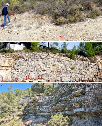
boundary at the GSSP site (Fig. 2.B-C ![]() ) near Pré Guittard pass (Fig.
2.A
) near Pré Guittard pass (Fig.
2.A ![]() )
to provide a second opinion (Granier, ed., 2017; Arai,
2017; Antunes, 2017), he did not take away the GSSP, but only duly referenced rock samples.
Similarly, ice cores from the NGRIP holes, 11 cm in diameter, stored in the
facilities of the University of Copenhagen do not represent the boundary
stratotype, but merely a continuous sampling around it.
)
to provide a second opinion (Granier, ed., 2017; Arai,
2017; Antunes, 2017), he did not take away the GSSP, but only duly referenced rock samples.
Similarly, ice cores from the NGRIP holes, 11 cm in diameter, stored in the
facilities of the University of Copenhagen do not represent the boundary
stratotype, but merely a continuous sampling around it.
|
|
Figure 2: B-E)
The
Aptian/Albian boundary (Albian GSSP arrowed) in the Trébou valley, west of the
Pré Guitard pass (A),
La Drôme (SE France). A: 23/05/2015; B: 26/05/2015; C, E:
25/05/2013; D: 21/05/2017. |
However, selecting a core as a GSSP represents a disruption to the global boundary-stratotype concept, as first outlined by Hedberg et al. (1976) and further developed by subsequent stratigraphers (Cowie et al., 1986; Salvador, ed., 1994; Remane et al., 1996). Additionally, it infringes on several requirements or recommendations of the International Commission on Stratigraphy (ICS).
It is noteworthy that Walker et al. (2008) highlighted the 'appropriateness of defining a global geological stratotype in an ice-core sequence.' However, while there are indeed advantages, such as the precise dating of the boundary through annual ice-layer counting and the detailed isotopic records, they are few and negligible compared to the disadvantages. As noted below, these Quaternary GSSPs based on cores do not meet important criteria required for validity.
The GSSPs for (the bases of) the
Northgrippian and Greenlandian stages (Walker et al.,
2018) are located in the NGRIP1 and NGRIP2
holes, respectively. They share the same Global Positioning System (GPS)
coordinates,
75°06'00.0"N, 42°19'12.0"W, which is the location of the drilling
site, not those of the points (see Fig.
3 ![]() ).
Besides, the given depths of
these GSSPs are 1228.67 m for the NGRIP1 well and 1492.45 m for the NGRIP2 well
(Walker et al., 2018). Because conversion tables for the measured core depths (MD) versus the
true vertical depths (TVD) are not available, the exact locations (latitude,
longitude, elevation) of both points are not known.
).
Besides, the given depths of
these GSSPs are 1228.67 m for the NGRIP1 well and 1492.45 m for the NGRIP2 well
(Walker et al., 2018). Because conversion tables for the measured core depths (MD) versus the
true vertical depths (TVD) are not available, the exact locations (latitude,
longitude, elevation) of both points are not known.
|
|
Figure 3:
Schematic
representation of vertical and deviated wells at the same location, showing the
relationship between measured depth (MD), true vertical depth referenced to
Kelly Bushing (TVDKB), true vertical depth referenced to the rotary table (TVDRT),
and true vertical depth below mean sea level (TVDSS). The diagram also
illustrates the GPS locations at the level markers, with the projections of the
marker locations on a horizontal plane separated by a distance referred to as
the run. |
Contrary to the assurances by Walker et al. (2008), the GSSPs for (the bases of) the Northgrippian and Greenlandian stages fail to meet the accessibility requirement. Regarding accessibility, Remane et al. (1996) wrote: 'Candidate sections in remote regions which can only be visited by organising costly expeditions should normally be excluded from the selection.' Clearly, Greenland sites do not meet this criterion. The chief accessibility issue is that new sampling of the location to facilitate the supplementation of information (for example, by including new paleontological groups or analyzing new chemical elements) is not straightforward although it should be. Thus, this requirement should be made mandatory. Easy access is crucial for replicating previous analyses and verifying their reproducibility. To achieve this, the material should be sufficiently abundant.
The two proposals by Walker et al. (2018) do not meet either key biostratigraphic requirements at their polar localities, such as the 'abundance and diversity of well-preserved fossils' (Cowie et al., 1986) 'throughout the critical interval' (Remane et al., 1996). In fact, they did not report any microfossil finds from there. Spores and pollen grains may be present, as biostratigraphy is required for Phanerozoic GSSP candidates, but this has never been tested in the ice cores. The reason for this is that, given the low concentration of microfossils in ice cores, sampling for spores and pollen grains would necessitate a significant and irreversible consumption of the initial ice-core volume.
Among the biostratigraphic requirements, it is stated that 'coastal and continental settings 'should' be avoided' (Remane et al., 1996). The author suggests replacing 'should' with 'must', making it a mandatory requirement rather than an optional suggestion. Subaqueous sections such as open marine environments, with their diversified biotas, offer the most 'favourable facies for long-range biostratigraphic correlations' (Remane et al., 1996).
Furthermore, because geochemical peaks repeat over time, correlating with any other ice core requires it to be long enough to allow for barcode correlation of the dust layers. Correlation with a sedimentary column, excluding an ice core, necessitates either biostratigraphic control or accurate numerical dating. The author 'has warned of stratigraphical misuse of geochemical curves' (Granier, 2012, 2014; Granier & Busnardo, 2013; Granier et al., 2024). This warning is valid for any purely physical or chemical data (e.g., barcodes of dust or polarity reversals of the Earth's magnetic field, peaks on geochemical curves). Scott et al. (2020, 2023) state that 'Chemostratigraphic Units' (...) 'may be associated with or bracketed by independent stratigraphic markers such as' (...) 'biostratigraphic zones, which aid in their identification'. Granier et al. (2024) supported this statement and even suggest referring to biochemostratigraphy rather than chemostratigraphy.
Remane et al. (1996) listed the 'absence of vertical facies changes at or near the boundary' under the 'Biostratigraphic requirements', not under the 'Geological requirements'. They justified this by stating that 'A change of litho- or biofacies reflects a change of ecologic conditions, which may have controlled the appearance of a given species at the boundary level.' What exactly is behind the definition of lithofacies? The author's experience suggests that this sedimentological issue requires further clarification and better documentation, as shown by the GSSPs for several Cretaceous stages.
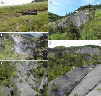
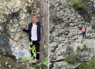
The Hauterivian GSSP (Mutterlose et al.,
2021) at La Charce (Drôme, SE France) is located
at the boundary between two types of marl and argillaceous limestone
alternations: thin beds and interbeds below the boundary, and thick beds and
interbeds above it. There are two contrasting lithologies - marls and limestones
- and two closely related but distinct stratinomic styles. However, it is
important to note that the interbedded lithologies are considered as a single
facies type: hemipelagic calcareous sedimentation. This boundary fulfills the
sedimentological requirements and, moreover, is easy to map in the area. For
instance, it is clearly identified (Fig. 4.A ![]() ) along the D173 road in the
Arnayon valley (GPS coordinates 44°28'54.2"N, 5°20'43.6"E) located approximately 8 km
westward of the La Charce site (Fig. 4.B-C
) along the D173 road in the
Arnayon valley (GPS coordinates 44°28'54.2"N, 5°20'43.6"E) located approximately 8 km
westward of the La Charce site (Fig. 4.B-C ![]() ; GPS coordinates
44°28'09.5"N,
5°26'37.5"E).
; GPS coordinates
44°28'09.5"N,
5°26'37.5"E).
|
|
Figure 4: A) The
Valanginian/Hauterivian boundary (arrowed) in the Arnayon valley, east of the Pré
Guitard pass, La Drôme, SE France (22/05/2024).
B) The
author and a visiting group of third year students from the Université de
Bretagne occidentale (Brest, Finistère) at the Hauterivian GSSP in La Charce,
La Drôme, SE France (22/05/2016). C) The
Hauterivian GSSP (arrowed) at La Charce (12/05/2020). |
Kennedy et al. (2004) reported the GPS coordinates of the Cenomanian GSSP at Mont Risou, Saint-André-de-Rosans (Hautes-Alpes, SE France), to be 44°23'33"N, 5°30'43"E. However, during a visit on May 23, 2024, the GPS coordinates recorded were 44°23'28"N, 5°30'39"E, some 170 meters to the SSW of the supposed location. This is not an isolated case; the Albian GSSP at Arnayon (Drôme, SE France) had GPS coordinates 44°30'28.3"N, 5°17'50.1"E on May 25, 2016 (Granier, 2017), some 1,700 meters to the SE of the reported location at 44°29'47.78"N, 5°15'42.36"E (Kennedy et al., 2017).
In both cases, the facies is rather homogeneous, consisting of the blue-grey marls or calcareous clays of the 'Marnes bleues' Formation. This facies is characteristic of pelagic sedimentation, having been deposited mostly below the Aragonite Compensation Depth, which explains the scarcity and even the absence of ammonite shells. Although some layering is visible at Arnayon, with a few marlstone layers and the organic-rich Kilian marker bed allowing the accurate identification of the base of the Albian in the middle of this Kilian level, the same is not true for the Mont Risou section. There, the base of the Cenomanian is located approximately 36 m below a prominent limestone bed, identified as the 'zero datum.' The GSSP is situated roughly one-third of the way down from the top of a 22-meter-thick, homogeneous marl interval, bounded by two 'better cemented, weathering-resistant intervals in marls' (located at -28 m and -50 m below the zero datum). However, due to the lack of distinct layering in the marl, the base of the Cenomanian is not straightforwardly visible in the field. The homogeneous facies, with no visible bedding and spanning at least 22 m, and more likely up to 120 m in thickness, suggests that this section was unsuitable for selection as a GSSP. Additionally, implanting a permanent 'Golden Spike' is impractical in an unconsolidated clayey substrate.
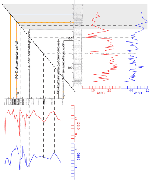
A nearby section (GPS coordinates 44°23'12.4"N,
5°30'45.9"E), approximately 500 meters South of the GSSP, was studied by Moons-Oudet
(2013). Thalmanninella reicheli (Mornod) is not reported in the
log shown in Kennedy et al. (2004) because no information on
planktonic foraminifers is available above -15 m (indicated by a grey interval
on Fig. 5 ![]() ). There are no records of Th. subticinensis (Gandolfi), Th.
tehamensis (Marianos et Zingula) and Th. ticinensis (Gandolfi)
in Moons-Oudet's log. Based on graphical correlations of key levels -
such as a layer with calcareous concretions in the lowermost part of both
sections, and the base and top of an alternation (orange lines on Fig. 5
). There are no records of Th. subticinensis (Gandolfi), Th.
tehamensis (Marianos et Zingula) and Th. ticinensis (Gandolfi)
in Moons-Oudet's log. Based on graphical correlations of key levels -
such as a layer with calcareous concretions in the lowermost part of both
sections, and the base and top of an alternation (orange lines on Fig. 5 ![]() ) - as
well as tentative biogeochemical correlations of some peaks in the δ13C
and δ18O curves (dashed lines on Fig. 5
) - as
well as tentative biogeochemical correlations of some peaks in the δ13C
and δ18O curves (dashed lines on Fig. 5 ![]() ), the First Occurrence
(FO) of Th. globotruncanoides (Sigal), and both the First (FO) and
Last (LO) occurrences of Th. gandolfii (Luterbacher et Premoli
Silva) appear lower in Moons-Oudet's section than in Kennedy's
section, by approximately 65 m, 75 m, and 20 m, respectively. It is noteworthy
that the primary proxy is reported approximately 65 m below the boundary it is
supposed to define at a site located just 500 m from the GSSP.
), the First Occurrence
(FO) of Th. globotruncanoides (Sigal), and both the First (FO) and
Last (LO) occurrences of Th. gandolfii (Luterbacher et Premoli
Silva) appear lower in Moons-Oudet's section than in Kennedy's
section, by approximately 65 m, 75 m, and 20 m, respectively. It is noteworthy
that the primary proxy is reported approximately 65 m below the boundary it is
supposed to define at a site located just 500 m from the GSSP.
|
|
Figure 5: Graphical
correlation of Moons-Oudet's (2013) and Kennedy's
(2004) logs,
represented on the X and Y axes, respectively. Caption: Grey patch = lack of
planktonic foraminifer analyses; orange lines = key lithologic layers; thin
black lines = key biostratigraphic markers; thin dashed blue lines = selected
peaks on the geochemical curves; thick dashed black line = line of correlation. |
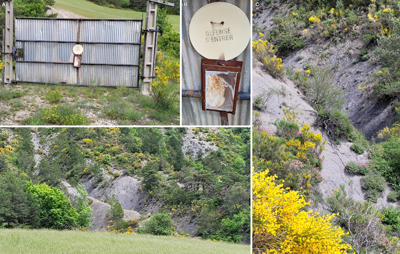
Finally, access to the GSSP site is
compromised (Fig. 6.A-D ![]() ): the track is blocked by a large steel gate bearing a
sign that prohibits entry to this private property, and the land is enclosed by
a barbed wire fence. It is likely that the original investigators excavated a
trench without obtaining prior permission from the landowners or the farmer.
): the track is blocked by a large steel gate bearing a
sign that prohibits entry to this private property, and the land is enclosed by
a barbed wire fence. It is likely that the original investigators excavated a
trench without obtaining prior permission from the landowners or the farmer.
|
|
Figure 6: Issues with the
Cenomanian GSSP at Mont Risou, Saint-André-de-Rosans (Hautes-Alpes, SE France),
23/05/2024. A) the steel gate; B) the warning sign; C) the
'typical outcrop' (Kennedy et al., 2013); D) the GSSP is hidden somewhere on the
hillside. |
The former candidate site and point for the Berriasian (Wimbledon et al., 2020) did not meet at least four 'geological requirements for a GSSP' (Granier et al., 2020).
Following the presentation of the
Berriasian GSSP candidate section (GPS coordinates 44°28'00.1"N, 5°49'40.7"E)
at a meeting of the Berriasian Working Group (BWG) in Bratislava on June 23,
2019, the author visited the Tré Maroua site (Fig. 7.A ![]() ) at Le Saix (Hautes-Alpes, France) on July 24, 2019, to make field
observations and collect samples for subsequent microscopic investigation. These
were shared with the voting members of the ISCS before the vote took place and
were published immediately afterward on February 22, 2020 (Granier et
al., 2020).
) at Le Saix (Hautes-Alpes, France) on July 24, 2019, to make field
observations and collect samples for subsequent microscopic investigation. These
were shared with the voting members of the ISCS before the vote took place and
were published immediately afterward on February 22, 2020 (Granier et
al., 2020).
In the aftermath of this public disclosure, the BWG team leader did not fully accept the negative outcome of the poll, despite the fact that 'Of the twenty-two persons in the Subcommission, eight (32%) voted against the proposal, eight voted "Yes", four did not vote, and two abstained' (Wimbledon et al., 2020, p. 160). However, the ICS statutes make it clear that approval requires that the votes in favour to equal or exceed 60% of the delivered votes, provided that a quorum of 60% has been attained. He also complained that the early version of their proposal 'received some negative comments produced by three members of the Subcommission' (Wimbledon et al., 2020, p. 160).
Although four
of the five 'geological requirements for a GSSP' were not met, eight of the ICSC
voting members disregarded this significant problem and cast positive votes. It
is assumed that most voting members of any
subcommission may not have visited the candidate sections before participating
in the poll. It is also noteworthy that some authors of proposals never
visited the candidate sections and points they studied, as their analyses were
based on material collected by another team member. For instance, at least two
coauthors of the (base) Albian GSSP (Kennedy
et al., 2017), did not visit the site until June 10, 2017, during an
excursion organized by the author (Granier,
ed., 2017). The author himself, who is a co-author of the proposal for the (base)
Barremian GSSP (Company et al., 2024), has not yet visited the Río Argos site (Caravaca,
SE Spain). However, as a co-author of the (base) Valanginian
GSSP (Reboulet et al., submitted), he has visited the site of
Vergol at Montbrun-les-Bains (Drôme, SE France) on several occasions (Fig.
7.B ![]() ). It is understood that each contributor to a GSSP, from the
specialist in the dedicated working group to the voting member in the relevant
subcommission, may not have had direct access to the site and point. For this
reason, the author suggests that they should be provided with a comprehensive
set of imagery to ensure the suitability of the exposure.
). It is understood that each contributor to a GSSP, from the
specialist in the dedicated working group to the voting member in the relevant
subcommission, may not have had direct access to the site and point. For this
reason, the author suggests that they should be provided with a comprehensive
set of imagery to ensure the suitability of the exposure.
|
|
Figure 7: A) The former candidate site and point for the
Berriasian of Tré Maroua site at Le Saix (Hautes-Alpes, France). Photo
courtesy of David Harper, 21/05/2023; B) The Valanginian GSSP
(arrowed) of Vergol at Montbrun-les-Bains (Drôme, SE France). Photo courtesy of
David Harper, 22/05/2023. |
According to Wimbledon
et al. (2020), the
primary proxy for the base of the Berriasian is the onset of the acme of Calpionella
alpina. This point was supposedly located approximately 8 m above the base
of their measured log (Fig. 7.A ![]() ).
However, Granier et al. (2020) argued that the proposed primary proxy should be
placed about 3 m lower, at the base of a debris flow. Additional samples (Granier
et al., 2023a) even revealed that the
boundary coincides with a fault, approximately 4 m below the proposed level.
Moreover, the critical interval surrounding this
boundary is riddled with calciturbidites and debris flows (Granier
et al., 2020, 2023a). A nearby
outcrop of the Tithonian/Berriasian boundary is the Le Chouet section at Les Près
(La Drôme, France; GPS coordinates 44°32'31.3"N, 5°33'35.7"E),
approximately 23 km to the WNW of Tré Maroua. According to Granier et
al. (2020), most 'bases of calpionellid zones and subzones', including the
Tithonian/Berriasian boundary (Fig. 8
).
However, Granier et al. (2020) argued that the proposed primary proxy should be
placed about 3 m lower, at the base of a debris flow. Additional samples (Granier
et al., 2023a) even revealed that the
boundary coincides with a fault, approximately 4 m below the proposed level.
Moreover, the critical interval surrounding this
boundary is riddled with calciturbidites and debris flows (Granier
et al., 2020, 2023a). A nearby
outcrop of the Tithonian/Berriasian boundary is the Le Chouet section at Les Près
(La Drôme, France; GPS coordinates 44°32'31.3"N, 5°33'35.7"E),
approximately 23 km to the WNW of Tré Maroua. According to Granier et
al. (2020), most 'bases of calpionellid zones and subzones', including the
Tithonian/Berriasian boundary (Fig. 8 ![]() ), 'are located at basal erosional
surfaces of turbidites or debris flows.' The bases of turbidites or debris flows
tend to be channelized and laterally discontinuous, making them neither
synchronous nor suitable as GSSPs or SABSs.
), 'are located at basal erosional
surfaces of turbidites or debris flows.' The bases of turbidites or debris flows
tend to be channelized and laterally discontinuous, making them neither
synchronous nor suitable as GSSPs or SABSs.
|
|
Figure 8: The
Tithonian/Berriasian boundary (arrowed) of Le Chouet (Granier et al.,
2023b) at Les Près
(Hautes-Alpes, France), 08/05/2018. |
As documented by Granier et al. (2020), the former (base) Berriasian GSSP candidate does not meet the rule of 'absence of synsedimentary and tectonic disturbances' (Remane et al., 1996) as it suffers from both issues. Although, the bases of some turbidites and debris flows may appear conformable with strata below and above, and show no apparent sign of basal erosion in the vertical section, it should be demonstrated that conformable bases are laterally extensive beyond a short distance from the reference section. If this requirement is not met, candidate sections and points in a turbiditic setting should be rejected. If such conditions are present in a current GSSP or SABS, it should be considered as a 'violation of accepted stratigraphic principles' (Remane et al., 1996), and an ad hoc working group should be established to review the situation.
Remark: Regardless of the results of the Berriasian Working Group, in the absence of a significant biological crisis during the transitional interval between the Tithonian and Berriasian stages, the GSSP of the Berriasian stage should not be considered de facto as the GSSP for the Cretaceous System. On the contrary, the Berriasian/Valanginian boundary, which corresponds to a major crisis impacting multiple groups of organisms (see Granier, 2019), should regain its status as the boundary between the Jurassic and Cretaceous systems. The author does not consider the Berriasian as the first stage of the Cretaceous System, but rather as the last stage of the Jurassic System.
Like
the Berriasian Working Group, the Aptian Working Group is still determining
where to place the point and locate the section. Currently, their preferences
are focused on the negative carbon isotope excursion (CIE) identified at the
C2/C3 boundary - i.e., the boundary between the second and third segments
of the δ13C
curve for Oceanic Anoxic Event (OAE) 1a (Menegatti et al.,
1998) -
as the primary proxy. They proposed the Cau section (Fig. 9.A ![]() ,
Province of Alicante, SE Spain; GPS coordinates: 38°42'13.4"N, 0°00'16.2"W)
with its set of cores (D1 to D4), as the candidate for the GSSP, and the Cismon
site (NE Italy; GPS coordinates: 46°02'43.46"N, 11°45'46.85"E) with
its AptiCore set (Fig. 10
,
Province of Alicante, SE Spain; GPS coordinates: 38°42'13.4"N, 0°00'16.2"W)
with its set of cores (D1 to D4), as the candidate for the GSSP, and the Cismon
site (NE Italy; GPS coordinates: 46°02'43.46"N, 11°45'46.85"E) with
its AptiCore set (Fig. 10 ![]() ),
as the candidate for the SABS.
),
as the candidate for the SABS.
Although
the geological significance of the event is clear, OAE1a (specifically its
segments C3-C6) was historically regarded as an intra-lower Aptian OAE, more
precisely within the Deshayesites forbesi Zone. The new boundary
criterion, however, redefines the C2/C3 segment boundary as the base of the
Aptian stage. This redefinition represents a significant upward shift, estimated
at approximately 60 m in the historical La Bédoule section (Fig.
9.B ![]() ) of Moullade et al.
(1998), and will complicate the use of past publications. Such a change implies
that the Aptian would lose about one-fourth of its total time range, along with
the transfer of at least one ammonite zone, the Deshayesites oglanlensis
Zone, into the Barremian. This alternative should not be validated, given the
long-standing historical precedent and the existence of suitable candidate sites
and points, including those near historical localities (e.g., Bert
et al., 2025).
) of Moullade et al.
(1998), and will complicate the use of past publications. Such a change implies
that the Aptian would lose about one-fourth of its total time range, along with
the transfer of at least one ammonite zone, the Deshayesites oglanlensis
Zone, into the Barremian. This alternative should not be validated, given the
long-standing historical precedent and the existence of suitable candidate sites
and points, including those near historical localities (e.g., Bert
et al., 2025).
|
|
Figure 9:
A) the candidate boundary on the side of a trail at Cau,
arrowed, 25/04/2024; B) the uppermost Barremian behind Moteurs Baudouin factory (former Villeneuve quarry) in Cassis, 24/09/2024.
C) the lowermost Aptian in the Brigadan candidate
section for the Aptian GSSP in Cassis (Bert et al.,
2025). Photo courtesy of
Didier Bert, 16/08/2025. |
Furthermore, the correlation criterion for the C2/C3 boundary is not necessarily as robust as believed. For instance, Vahrenkamp (1996) purportedly identified the OAE1a in the shallow-water Shu'aiba Formation of the United Arab Emirates based on a δ13C curve and poorly constrained biostratigraphic data, placing the negative CIE at the base of his 'Sequence Apt 2'. Later, similar features were reported in Oman (Vahrenkamp, 2010). However, these chemostratigraphic interpretations conflict with ammonite records (Busnardo & Granier, 2011; Granier & Busnardo, 2013). Specifically, the identification of the Epicheloniceras martini Zone within the maximum flooding interval (MFI) of 'Sequence Apt 2' (Vahrenkamp, 2010) is inconsistent with this interpretation. This interval corresponds to a condensed section equivalent to the Highstand System Tract (HST) of the Shu'aiba Formation, as described by Granier (2008: Fig. 9). According to Vahrenkamp (1996, 2010), his purported equivalent of the OAE1a C3-C4 segments is assigned to the 'Deshayesites deshayesi Zone.' However, the author (Granier (2012, 2014) noted that this interval cannot be older than the Dufrenoyia furcata Zone, thereby precluding its assignment to the OAE1a. Yamamoto et al. (2013) repeated the same error as Vahrenkamp (2010) when analyzing similar wells from the same region (Granier, 2014). In conclusion, chemostratigraphy should not be applied without a robust biostratigraphic context. Instead, the concept of biochemostratigraphy (Granier et al., 2024) should be employed, wherein the primary marker is a biostratigraphic proxy and the secondary marker is a chemostratigraphic proxy used to refine the information provided by the primary marker.
Mathieu
Martinez (personal communication, 14/05/2024) provided the author with
estimates for the duration of the C3-C4 segments, ranging from 470 to 747 ka.
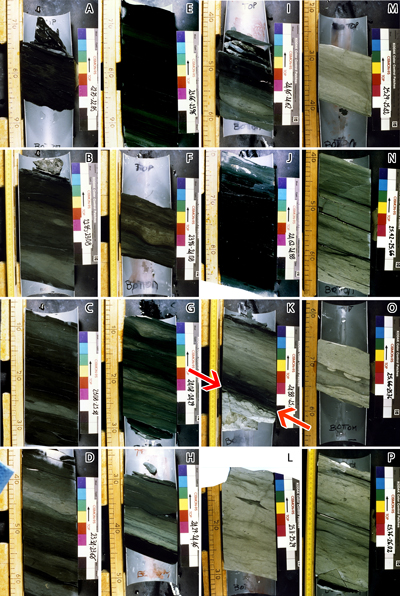
This interval measures 880 mm at Gorgo a Cerbara, 1,580 mm in the AptiCore
(1,500 mm, considering that the cores are cut at an angle of 20°; Fig.
10 ![]() ),
11,090 mm at La Bédoule, and 11,670 mm at Cau. According to Baraboshkin
(2009), condensed sections sensu stricto are characterized by
sedimentation rates (after compaction) ranging from 5 to 10 mm/ka, while
ultracondensed sections exhibit rates below this range. With sedimentation rates
of 1.2 to 1.9 mm/ka and 2.0 to 3.2 mm/ka, respectively, both Gorgo a Cerbara and
Cismon record ultracondensed sedimentation and should not be considered valid
candidates for a GSSP or a SABS. In contrast, sedimentation rates at La Bédoule
and Cau range from 14.8 to 23.6 mm/ka and 15.6 to 24.8 mm/ka, respectively.
These rates place both Cau and La Bédoule sections outside the condensed
section category.
),
11,090 mm at La Bédoule, and 11,670 mm at Cau. According to Baraboshkin
(2009), condensed sections sensu stricto are characterized by
sedimentation rates (after compaction) ranging from 5 to 10 mm/ka, while
ultracondensed sections exhibit rates below this range. With sedimentation rates
of 1.2 to 1.9 mm/ka and 2.0 to 3.2 mm/ka, respectively, both Gorgo a Cerbara and
Cismon record ultracondensed sedimentation and should not be considered valid
candidates for a GSSP or a SABS. In contrast, sedimentation rates at La Bédoule
and Cau range from 14.8 to 23.6 mm/ka and 15.6 to 24.8 mm/ka, respectively.
These rates place both Cau and La Bédoule sections outside the condensed
section category.
Besides
their sedimentation rates, the Gorgo a Cerbara and Cismon sites are unsuitable
for other reasons. For example, the facies change abruptly at 25.03 m in core
15, which is the boundary between units 4 and 5 (Erba & Larson,
1998: Fig. 5), as seen in archival photographs of the AptiCore (Fig.
10 ![]() ).
The vertical facies change at the boundary, occurring on a firmground, indicates
a hiatus, another characteristic that should have disqualified this site from
consideration.
).
The vertical facies change at the boundary, occurring on a firmground, indicates
a hiatus, another characteristic that should have disqualified this site from
consideration.
|
|
Figure 10: Core photographs from the AptiCore drilling at Cismon
(excerpts from https://mlp.ldeo.columbia.edu/data/cismon/core_photos/). Erba's
and Larson's 4/5 unit boundary (i.e., Menegatti's C2-C3
segment boundary) is arrowed in red on K. A-F: core 14 pars, A)
22.75-22.85 m; B) 22.85-23.08 m; C) 23.08-23.34 m; D) 23.34-23.66 m; E)
23.66-23.96 m; F) 23.96-24.08. G-P: core 15 pars, G) 24.08-24.29 m; H)
24.29-24.46 m; I) 24.46-24.62 m; J) 24.62-24.88 m; K) 24.88-25.11 m; L)
25.11-25.29 m; M) 25.29-25.42: N) 25.42-25.66 m; O) 25.66-25.76 m; P)
25.76-26.02 m. |
Inconsistencies in the approaches to establish Global Stratotype Sections and Points and Standard Auxiliary Boundary Stratotypes indicate the need to elevate some existing recommendations to rules, introduce new recommendations ('should') and rules ('must'), and enforce stricter adherence to both current and future guidelines in the selection and definition of GSSPs and SABSs.
1) Any candidate based on subsurface material such as a core from a drill hole or well is inherently unsuitable as a boundary stratotype or auxiliary boundary because it violates the principle of geographical (latitude and longitude) and topographical (elevation) uniqueness. The location of such a site is necessarily defined by its position within the hole at depth, with the reference point located in the subsurface, which, by nature, impedes any easy and unrestricted access. Additionally, the ice record in the critical interval for the lower boundaries of the Northgrippian and Greenlandian stages lacks biostratigraphic information, which would have otherwise resulted in irreversible destruction of the material concerned. Furthermore, the reproducibility of measurements in ice cores is either very limited or impossible. Therefore, it is suggested that existing well and core GSSPs be abandoned, and new ad hoc working groups to identify better candidates for the same GSSPs be selected. More broadly, any new GSSP or SABS candidate based on a well and sedimentary core must be ruled out from the outset, as a unique site and point cannot be ubiquitous.
2) Astronomically controlled deposits, such as the marl and argillaceous limestone alternations of the Valanginian-Hauterivian in the La Drôme department (SE France), should be treated as a single hemipelagic facies, even though they exhibit two lithologies and various stratinomic styles. In contrast, non-cyclical alternations related to turbiditic deposits within pelagic sedimentation, such as the debris flows and turbidites found at the former Berriasian GSSP candidate site in the Les Hautes-Alpes department (SE France), are unsuitable intervals for identifying GSSPs or SABSs because the 'sharp lithofacial change' at the bottom of each debris flow or turbidite marks an erosional surface, indicating a hiatus that may be more or less significantly developed laterally. Therefore, it is suggested that if any past GSSP or SABS coincides with an erosional surface at the bottom of a debris flow or turbidite, it must be abandoned, and a new ad hoc working group should be appointed. More broadly, any new GSSP or SABS candidate in a turbiditic setting must be ruled out from the start.
3) Homogeneous critical intervals lacking visible layering must be considered unsuitable for the location of GSSPs or SABSs because the boundary cannot be immediately and easily identified. Additionally, it may not be feasible to place a permanent 'Golden Spike' at some clayey or marly sites. This issue is exemplified by the Cenomanian GSSP at Mont Risou, which must be abandoned for these reasons, among others.
4) Finally, the action on the Berriasian proposal (Granier et al., 2020, versus Wimbledon et al., 2020) demonstrates the importance that voting member have first-hand field-work knowledge of the candidate sections. To a lesser degree, the same concern applies to members of the working groups. It is suggested that proposals should include a comprehensive set of field photographs, videos, or Digital Terrain Model (DTM) and Digital Surface Model (DST) derived from drone imagery to ensure the suitability of candidate GSSP or SABS exposures.
In conclusion, several examples of approved and candidate Phanerozoic GSSPs and/or SABSs reviewed here do not meet the recommended criteria (Hedberg et al., 1976; Cowie et al., 1986; Salvador, ed., 1994; Remane et al., 1996). The author proposes that all well-established criteria of future Phanerozoic GSSPs and SABSs be thoroughly documented before a proposal is submitted. Furthermore, it is recommended that already approved GSSPs and SABSs be reassessed to ensure that documentation is complete, and that each site, as a potential World Heritage Site, is protected and accessible to both researchers and the general public, in accordance with the philosophy of the GSSP. Aside from the issue of accessibility, although the identification of a boundary may appear more photogenic on core material than in most field outcrops, the location of the section (i.e., the drill hole) and the specific point on the core are, by nature, not unique, an aspect that also contradicts the general philosophy of the GSSP.
Field work was made possible thanks to a grant from the Foundation "Carnets de Géologie". The author thanks Mme D. Millon (Maire de Cassis), Mmes M. Feraud, B. Muylle, and D. Zamour (Ville de Cassis), Mme L. Marradi, Messrs Ph. Beltrando (Adjoint au Maire de Roquefort-La Bédoule) and P.-Y. Chabaud (Roquefort-La Bédoule), Mme S. Ababsa (Moteurs Baudouin), Mmes G. Mourre Miellou and F. Reynaud Miellou (Saint-André-de-Rosans), Mme F. Santiago, Messrs Ph. Charlot and S. Lagrange (Lafarge Granulats) for granting permission to access certain sites.
He also extends his gratitude to Claudine Moons-Oudet, Stéphane Bersac, Didier Bert, Serge Ferry, David Harper, Bernard Lambert, Eric Monteil, Gilles Serge Odin, and Stéphane Reboulet for providing unpublished documentation and photos used in this paper. Appreciation is also extended to the reviewers S.G. Lucas, J.G. Ogg, B.R. Pratt, and R.W. Scott, as well as to S.K. Lee, the Editor-in-Chief, and the three anonymous reviewers of the journal Episodes, to which the manuscript was originally submitted, for their valuable comments and suggestions. Special thanks are also due to Phil Salvador, who kindly reviewed the final version of the text. Measurements of the δ13C and δ18O from Moons-Oudet's (2013) PhD were made by Christophe Lecuyer.
Antunes R.L. (2017).- Calcareous nannofossils from Aptian-Albian transition (France): Preliminary results. In: Granier B. (ed.), Some key Lower Cretaceous sites in Drôme (SE France).- Association Carnets de Géologie, Madrid, CG2017_B01, p. 66-77. DOI: 10.4267/2042/62543
Arai M. (2017).- Palynomorphs from Aptian-Albian transition (France): Preliminary results. In: Granier B. (ed.), Some key Lower Cretaceous sites in Drôme (SE France).- Association Carnets de Géologie, Madrid, CG2017_B01, p. 53-65. DOI: 10.4267/2042/62543
Baraboshkin E.Yu. (2009).- Condensed sections: Terminology, types, and accumulation conditions.- Moscow University Geology Bulletin, vol. 64, no. 3, p. 153-160.
Bert D., Bersac S. & Dutour Y. (2025).- Preliminary investigations of an Aptian GSSP candidate at the historical Bedoulian locality near Cassis (Bouches-du-Rhône) and complementary section at the stratotype Barremian locality at Angles (Alpes-de-Haute-Provence).- Carnets Geol., Madrid, vol. 25, no. 15, p. 307-317. DOI: 10.2110/carnets.2025.2515
Busnardo R. & Granier B. (2011).- Aptian ammonites of Abu Dhabi (United Arab Emirates).- Carnets Geol., Madrid, vol. 11, no. L04 (CG2011_L04), p. 117-135. DOI: 10.4267/2042/43895
Company M., Aguado. R., Baudin F., Coccioni R., Martinez M., Rawson P.F., Weissert H., Deconinck J., Frontalini F., Giusberti L., Granier B., Janssen N.M.M., Moiroud M., Monna F., ODogherty L., Pellenard P., Riquier L., Romero G., Sandoval J. & Tavera J.M. (2024).- The global boundary stratotype section and point (GSSP) of the Barremian stage at Río Argos (Caravaca, SE Spain).- Episodes, Seoul, vol. 47, no. 2, p. 335-379. DOI: 10.18814/epiiugs/2023/02330
Cowie J.W., Ziefler W., Boucot A.J., Bassett M.G. & Remane J. (1986).- Guidelines and statutes of the International Commission on Stratigraphy (ICS).- Courier Forschungsinstitut Senckenberg, vol. 83, p. 1-14.
Erba E., Channell J.E.T., Claps M., Jones C., Larson R., Opdyke B., Premoli Silva E., Riva A., Salvini G. & Torricelli S. (1999).- Integrated stratigraphy of the Cismon APTICORE (Southern Alps, Italy): A "reference section" for the Barremian-Aptian interval at low latitudes.- The Journal of Foraminiferal Research, Lawrence - KS, vol. 29, no. 4, p. 371-391.
Granier B. (2000).- Lower Cretaceous stratigraphy of Abu Dhabi and the United Arab Emirates - A reappraisal.- The 9th Abu Dhabi International Petroleum Exhibition & Conference, October 15th-18th, Conference Proceedings, Abu Dhabi, ADIPEC 0918, p. 526-535.
Granier B. (2008).- Holostratigraphy of the Kahmah regional Series in Oman, Qatar, and the United Arab Emirates.- Carnets Geol., Madrid, vol. 8, no. A07 (CG2008_A07), p. 1-33. DOI: 10.4267/2042/19112
Granier B. (2012).- Geochemical correlations of Shu'aiba sections: Stop trusting the trends! In: Gawlick H.J. & Missoni S. (eds.), Sedimentology in the hearth of the Alps.- CD-ROM, 29th IAS Meeting of Sedimentology (10th-13th September, Schladming), p. 361.
Granier B. (2014).- Comment on "Early Aptian paleoenvironmental evolution of the Bab Basin at the southern Neo-Tethys margin: Response to global-carbon cycle perturbations across Ocean Anoxic Event 1a" by K. Yamamoto et al.- Geochemistry, Geophysics, Geosystems, vol. 15, no. 5, p. 2086-2090. DOI: 10.1002/2014GC005350
Granier B. (2017).- Introductory remarks. In: Granier B. (ed.), Some key Lower Cretaceous sites in Drôme (SE France).- Association Carnets de Géologie, Madrid, CG2017_B01, p. 2-5. DOI: 10.4267/2042/62543
Granier B. (2019).- Dual biozonation scheme (benthic foraminifera and "calcareous" green algae) over the Jurassic-Cretaceous transition. Another plea to revert the system boundary to its historical Orbigny's and Oppel's definition. In: Granier B. (ed.), VSI: The transition of the Jurassic to the Cretaceous: An early XXIth century holistic approach.- Cretaceous Research, vol. 93, p. 245-274.
Granier B. & Busnardo R. (2013).- New stratigraphic data on the Aptian of the Persian Gulf. In: Skelton P., Granier B. & Moullade M. (eds.), Special issue: Spatial patterns of change in Aptian carbonate platforms and related events.- Cretaceous Research, vol. 39, p. 170-182.
Granier B., Ferry S. & Benzaggagh M. (2020).- A critical look at Tré Maroua (Le Saix, Hautes-Alpes, France), the Berriasian GSSP candidate section.- Carnets Geol., Madrid, vol. 20, no. 1, p. 1-17. DOI: 10.4267/2042/70714
Granier B., Benzaggagh M. & Ferry S. (2023a).- Revised holostratigraphy of the Tithonian-Berriasian transition at Tré Maroua (Le Saix, Hautes-Alpes, SE France): Study of a rejected Berriasian GSSP candidate.- Volumina Jurassica, Varsaw, vol. XXI, p. 1-18.
Granier B., Ferry S. & Benzaggagh M. (2023b).- Hiatuses and redeposits in the Tithonian-Berriasian transition at Le Chouet (Les Près, La Drôme, SE France): Sedimentological and biostratigraphical implications.- Carnets Geol., Madrid, vol. 23, no. 7, p. 123-147. DOI: 10.2110/carnets.2023.2307
Granier B., Ferry S. & Blau J. (2024).- Comments on "Slight carbon-isotope perturbation at the J/K boundary (base of the Calpionella Zone) - A proxy tool for correlation? A brief summary".- Cretaceous Research, vol. 158, article 105787, p. 1-7.
Hedberg H.D. (ed., 1976).- International stratigraphic guide. A guide to stratigraphic classification, terminology and procedure.- John Wiley and Sons, New York, 200 p.
Kennedy W.J., Gale A.S., Lees J.A. & Caron M. (2004).- The Global Boundary Stratotype Section and Point (GSSP) for the base of the Cenomanian Stage, Mont Risou, Hautes-Alpes, France.- Episodes, Seoul, vol. 27, no. 1, p. 21-32. DOI: 10.18814/epiiugs/2004/v27i1/003
Kennedy W.J., Gale A.S., Huber B.T., Petrizzo M.R., Bown P. & Jenkyns H.C. (2017).- The Global Boundary Stratotype Section and Point (GSSP) for the base of the Albian Stage of the Cretaceous, the Col de Pré-Guittard section, Arnayon, Drôme, France.- Episodes, Seoul, vol. 40, no. 3, p. 177-188. DOI: 10.18814/epiiugs/2017/v40i3/017021
Menegatti A.P., Weissert H., Brown R.S., Tyson R.V., Farrimond P., Strasser A. & Caron M. (1998).- High resolution δ13C stratigraphy through the early Aptian "Livello Selli" of the Alpine Tethys.- Paleoceanography, Washington - DC, vol. 13, no. 5, p. 530-545.
Moons-Oudet C. (2013).- Évolution des associations de foraminifères comme bio-indicateurs des paléoenvironnements : Le bassin subalpin (bassin vocontien et sa marge occidentale) au Cénomanien.- PhD thesis, Université de Strasbourg, 252 p.
Moullade M., Tronchetti G. & Masse J.-P. (1998).- Le stratotype historique de l'Aptien inférieur (Bédoulien) dans la région de Cassis-La Bédoule (S.E. France).- Géologie Méditerranéenne, Marseille, t. XXV, no. 3-4, 298 p.
Mutterlose J., Rawson P.F., Reboulet S., Baudin F., Bulot L., Emmanuel L., Gardin S., Martinez M. & Renard M. (2021).- The Global Boundary Stratotype Section and Point (GSSP) for the base of the Hauterivian Stage (Lower Cretaceous), La Charce, southeast France.- Episodes, Seoul, vol. 44, no. 2, p. 129-150. DOI: 10.18814/epiiugs/2020/020072
Odin G.S. & Lamaurelle M.A. (2001).- The global Campanian-Maastrichtian stage boundary. Episodes, Seoul, vol. 24, no. 4, p. 229-238. DOI: 10.18814/epiiugs/2001/v24i4/002
Reboulet S., Company M., Adatte T., Aguado R., Baudin F., Deconinck J.-F., Duxbury S., De Gea G., Grabowski J., Granier B., Ivanova D., Janssen N., Klein J., Lakova I., Leng M., Lodowski D., Martinez M., Mattioli E., McArthur J., Olivero D., Reháková D. & Tavera J.M. (2025).- The Global Boundary Stratotype Section and Point (GSSP) for the base of the Valanginian Stage, the Vergol section (Montbrun- les-Bains, Drôme, SE France) and its Standard Auxiliary Boundary Stratotype (SABS), Cañada Luenga section (Cehegín, SE Spain).- Episodes, Seoul, vol. 48, no. 4, 85 p. DOI: 10.18814/epiiugs/2025/025028
Remane J., Bassett M.G., Cowie J.W., Gohrbandt K.H., Lane R.L., Michelsen O. & Wang N. (1996).- Revised guidelines for the establishment of global chronostratigraphic standards by the International Commission on Stratigraphy (ICS).- Episodes, Seoul, vol. 19, no. 3, p. 77-81. DOI: 10.18814/epiiugs/1996/v19i3/007
Salvador A. (ed., 1994).- International stratigraphic guide. A guide to stratigraphic classification, terminology and procedure, 2nd edition.- IUGS and the Geological Society of America, 214 p.
Scott R.W., Brett C.B., Fluegeman R.H., Pratt B.R. & Landing E. (2020).- North American Commission on Stratigraphic Nomenclature. Note 71 - Application for addition of chemostratigraphic units to the North American Stratigraphic Code: A case for formalizing chemostratigraphic units.- Stratigraphy, Flushing - NY, vol. 17, no. 2, p. 135-139. DOI: 10.29041/strat.17.2.135-139
Scott R.W., Brett C.B., Fluegeman R.H., Pratt B.R. & Landing E. (2023).- North American Commission on Stratigraphic Nomenclature. Report 15 - revised articles 2, 61 and 62 of the North American Stratigraphic Code to formalize chemostratigraphic units.- Stratigraphy, Flushing - NY, vol. 20, no. 3, p. 233-236. DOI: 10.29041/strat.20.3.03
Vahrenkamp V.C. (1996).- Chemostratigraphy on the Lower Cretaceous Shu'aiba Formation: A δ13C reference profile for the Aptian stage from the southern Neo-Tethys Ocean.- AAPG Bulletin, Tulsa - OK, vol. 80, no. 5, p. 647-662.
Vahrenkamp V.C. (2010).- Chemostratigraphy on the Lower Cretaceous Shu'aiba Formation: A δ13C reference profile for the Aptian stage from the southern Neo-Tethys Ocean.- Geoarabia, Manama, Special Publication 4, vol. 1, p. 107-137.
Walker M., Johnsen S., Rasmussen S.O., Steffensen J.-P., Popp P., Gibbard P., Hoek W., Lowe J., Andrews J., Björck S., Cwynar L., Hughen K., Kershaw P., Kromer B., Litt T., Lowe D.J., Nakagawa T., Newnham R. & Schwander J. (2008).- The Global Stratotype Section and Point (GSSP) for the base of the Holocene Series/Epoch (Quaternary System/Period) in the NGRIP ice core.- Episodes, Seoul, vol. 31, no. 2, p. 264-267. DOI: 10.18814/epiiugs/2008/v31i2/016
Walker M., Head M.J., Berkelhammer M., Björck S., Cheng H., Cwynar L., Fisher D., Gkinis V., Long A., Lowe J., Newnham R., Rasmussen S.O. & Weiss H. (2018).- Formal ratification of the subdivision of the Holocene Series/Epoch (Quaternary System/Period): Two new Global Boundary Stratotype Sections and Points (GSSPs) and three new stages/subseries.- Episodes, Seoul, vol. 41, no. 4, p. 213-223. DOI: 10.18814/epiiugs/2018/018016
Walsh S.L., Gradstein F.M. & Ogg J.G. (2004).- History, philosophy, and application of the Global Stratotype Section and Point (GSSP).- Lethaia, Oslo, vol. 37, no. 2, p. 201-218.
Wimbledon W.A.P, Reháková D., Svobodová A., Elbra T., Schnabl P., Pruner P., ifnerová K., Kdýr ., Frau C., Schnyder J., Galbrun B., Vaňková L., Dzyuba O., Copestake P., Hunt C.O., Riccardi A., Poulton T.P., Bulot L.G. & De Lena L. (2020).- The proposal of a GSSP for the Berriasian Stage (Cretaceous System): Part 2.- Volumina Jurassica, Varsaw, vol. XVIII, no. 1, p. 53-106. URL: https://vjs.pgi.gov.pl/article/view/29279
Yamamoto K., Ishibashi M., Takayanagi H., Asahara Y., Sato T., Nishi H. & Iryu Y. (2013).- Early Aptian paleoenvironmental evolution of the Bab Basin at the southern Neo-Tethys margin: Response to global carbon-cycle perturbations across Ocean Anoxic Event 1a.- Geochemistry, Geophysics, Geosystems, vol. 14, no. 4, p. 1104-1130. DOI: 10.1002/ggge.20083
[*] To put it simply, both the section and the point cannot be located in two different places (uniqueness rule).