Carnets de Géologie / Notebooks on Geology: Book 2009/03, Chapter 3 (CG2009_B03/03)
![]()
![]()
J.-S. (2009).- The GeoPark of Haute-Provence, France - Geology and palaeontology protected for sustainable development.- In: J.H. & B.R.C. (eds.), PaleoParks - The protection and conservation of fossil sites worldwide.- Carnets de Géologie / Notebooks on Geology, Brest, Book 2009/03, Chapter 03 (CG2009_B03/03)
The GeoPark of Haute-Provence, a "Réserve Naturelle Nationale à Vocation Géologique" (National Natural Geological Reserve), is located in Southeastern France in the foothills of the Western Alps. It covers over 2,000 square kilometres inhabited by 33,000 people, in which the geological heritage is protected for use in the sustainable development of this rural territory. The GeoPark contains sedimentary rocks deposited on the northern margin of the Tethys Sea that have been differently affected by Alpine orogenesis. These rocks range in age from Triassic to Pleistocene and contain fossils throughout. Not only is the GeoPark itself worthy of designation as a PaleoPark, many of the individual palaeontological sites could also be designated as separate PaleoParks in order to capitalize on their educational and research values.
France; Provence; geology; palaeontology; preservation; GeoParks.
Le Géoparc de Haute Provence, France - Géologie et paléontologie protégées pour un développement durable.- Le Géoparc de Haute-Provence est une réserve naturelle nationale à vocation géologique située dans le Sud-Est de la France. Sur un territoire de plus de 2.000 km2, le patrimoine géologique est protégé et utilisé comme outil pour le développement durable d'un territoire rural.
France ; Provence ; géologie ; paléontologie ; patrimoine ; Géoparcs.
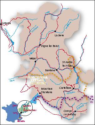
Equidistant from Nice, Marseille and Grenoble, the GeoPark of
Haute-Provence occupies a Mediterranean upland area in Southeastern France (Fig. 1 ![]() ).
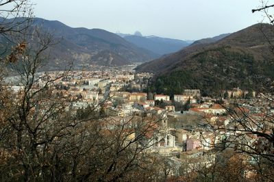
The GeoPark's territory lies around the town of Digne-les-Bains (Fig.
2
).
The GeoPark's territory lies around the town of Digne-les-Bains (Fig.
2 ![]() ),
chef-lieu (administrative capital) of the Alpes de Haute-Provence département,
between the Durance and Verdon valleys. It ranges in altitude from 400 to 2,940
metres above sea level, with very distinct seasons and rainfall that is highly
variable over the year, resulting in relative aridity overall. Combined with
human activity, this aridity has contributed to stripping the relief of its
vegetation, thereby making geological outcrops more accessible and facilitating
their interpretation. Thus, since the 19th century the region has enjoyed an
excellent reputation among palaeontologists as an area with rich
palaeontological resources (In the early 1800s Alcide d', for example,
had many correspondents here and actually visited the area). Although densely
populated in the past, today, after the rural exodus of the late 19th century
and the depopulation following World War I, the region possesses vast expanses
in which Nature is gradually regaining its rights.
),
chef-lieu (administrative capital) of the Alpes de Haute-Provence département,
between the Durance and Verdon valleys. It ranges in altitude from 400 to 2,940
metres above sea level, with very distinct seasons and rainfall that is highly
variable over the year, resulting in relative aridity overall. Combined with
human activity, this aridity has contributed to stripping the relief of its
vegetation, thereby making geological outcrops more accessible and facilitating
their interpretation. Thus, since the 19th century the region has enjoyed an
excellent reputation among palaeontologists as an area with rich
palaeontological resources (In the early 1800s Alcide d', for example,
had many correspondents here and actually visited the area). Although densely
populated in the past, today, after the rural exodus of the late 19th century
and the depopulation following World War I, the region possesses vast expanses
in which Nature is gradually regaining its rights.
In the GeoPark, only some 33,000 inhabitants (16,000 in rural areas and 17,000 in Digne city) live within the Reserve. Two population censuses, taken roughly four years apart, reveal there has been little change. Consequently if the population density is 150 inhab./km2 for the main town, it reaches only 15.54 inhab./km2 for the whole area.
The ruggedness of the territory makes life very hard: 34.3% of the total population are retired and 19% have no professional activity. Industry is virtually non-existent both in the département as a whole and in the territory of the Reserve; the entire economy is based on agricultural activity centered around sheep-raising. In this area where human activity exerts little pressure, except for those traditional modes that have contributed to shaping the landscapes, tourism represents a considerable economic asset, whether in the area of sport or the arts, or oriented towards nature and geology.
La Réserve Géologique de Haute-Provence is located in the foothills of the Western Alps: on the boundary between the area of the Southern Subalpine massifs shaped by overthrusts of moderate amplitude and the limestone formations of Provence whose tectonic evolution results from the early phases and thus was less affected by Alpine orogenesis proper. Nonetheless, the two areas, although possessing minor differences in their evolution, both belong to the northern (or European) margin of the Tethys sea.
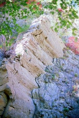
The Southern Subalpine massifs correspond in fact to the Mesozoic sediments
deposited on the European platform. These Mesozoic deposits (Figs.
3 ![]() - 4
- 4 ![]() ) vary in
thickness and are more or less complete from place to place, thereby
illustrating the effect of the opening and closing of the Tethys Sea. The
Mesozoic series end locally in flysch-type Palaeogene deposits attributable to
the Alpine orogenic cycle. Study of the various components of these series shows
their evolution both in time and in space, demonstrating the existence of
changing palaeogeography, as opposed to a more subsiding area to the north and
the platform region to the south.
) vary in
thickness and are more or less complete from place to place, thereby
illustrating the effect of the opening and closing of the Tethys Sea. The
Mesozoic series end locally in flysch-type Palaeogene deposits attributable to
the Alpine orogenic cycle. Study of the various components of these series shows
their evolution both in time and in space, demonstrating the existence of
changing palaeogeography, as opposed to a more subsiding area to the north and
the platform region to the south.
The Mesozoic deposits begin in the Triassic with a succession of continental facies, evaporates and then marine deposits, characteristic of the onset of the opening of the ocean. In the Jurassic, the differences between north and south became stronger, each zone developing its own specific character. In both the Jurassic and the Cretaceous, the effects of tectonic control on sedimentation are clearly visible everywhere. In the upper Cretaceous, the subsidence focus shifts northward as it becomes attenuated.
To the south, in Provence in particular, there were highlands (Durancian bulge). They are linked with new tectonic activity due to the northward movement of the African plate as a result of the opening of the Atlantic. At the Cretaceous/Cenozoic boundary, the Subalpine massifs emerged and underwent erosion.
In the Nummulitic (Eocene), the sea transgressed the Subalpine domain from the east and various kinds of sediments were deposited, some of which truly display the characteristics of flysch, like the sandstone of Annot and its equivalents. The western part of the Subalpine massifs remained protected, however, from this transgression and received continental sedimentation, known under the generic term of red molasse, which continued throughout the Oligocene, as the sea gradually retreated from the East.
In the Miocene a new transgression took place, this time from the west,
covering only a limited part of the Provence region. At the same time, the
structural building phases led gradually to the present tectonic regime (Fig.
5 ![]() ). This structural activity probably persisted into the Pleistocene. When these
were completed, a new geodynamic factor contributed to shaping the region--the
great glaciations of the Quaternary which had influence as far south as Provence.
). This structural activity probably persisted into the Pleistocene. When these
were completed, a new geodynamic factor contributed to shaping the region--the
great glaciations of the Quaternary which had influence as far south as Provence.
From a palaeontological standpoint, the Palaeozoic through Pleistocene in the
region has yielded a great variety of fossils. The Palaeozoic era is represented
by fossil ferns from the Carboniferous period. But most of the fossils are
marine organisms dating from the Mesozoic. Ammonites--both Jurassic and
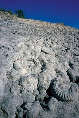
Cretaceous--are particularly numerous: in addition to the famous Sinemurian
ammonite slab in Digne (Fig. 6 ![]() ), Callovo-Oxfordian deposits and Lower Cretaceous
strata contain abundant uncoiled ammonites, including the Barremian in
particular, whose stratotype is located in the heart of the Réserve Géologique.
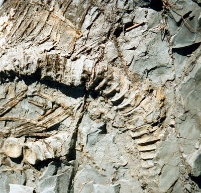
Besides the ammonites, the GeoPark is also famous for several ichthyosaur
fossils (Fig. 7
), Callovo-Oxfordian deposits and Lower Cretaceous
strata contain abundant uncoiled ammonites, including the Barremian in
particular, whose stratotype is located in the heart of the Réserve Géologique.
Besides the ammonites, the GeoPark is also famous for several ichthyosaur
fossils (Fig. 7 ![]() )
from both the Jurassic and the Cretaceous periods.
)
from both the Jurassic and the Cretaceous periods.
The Mesozoic Era has abundant fossils, as does the Cainozoic, with a variety
of deposits in less stable palaeogeographic settings. The most spectacular
include sirenian bones (Eocene) (Fig. 8 ![]() )
and bird tracks (Miocene).
)
and bird tracks (Miocene).
The Natural Geological Reserve of Haute-Provence, home to the GeoPark, was founded in 1984, pursuant to the 1976 Law on the protection of Nature to preserve palaeontological deposits from looting. The prime tool for such protection was, and remains, educating the public of the value of the geological and palaeontological heritage, rather than repressive measures, although strict enforcement of regulations remains an inevitable necessity.
At the start, only 18 rather limited sites were protected, but, over the years, pursuant to the Law, a peripheral zone was created, with less stringent constraints, but ensuring proper conservation of the geological heritage. Founded in 1989 with 36 communes around Digne-les-Bains, this protected area today covers 2,100 square kilometres and 55 communes in two départements (Alpes de Haute-Provence and Var). Overall, in this vast territory, no fossils may be collected. Only professionals and recognized amateurs may obtain special permits for scientific purposes.
Raising public awareness has taken two directions: addressing the territory's inhabitants with special emphasis on local schools and events in villages, on the one hand, and targeting visitors through discovery trails and museums, on the other. Raising awareness among the territory's inhabitants has led to their appropriation of this forgotten heritage, since fossils have always been part of the local people's traditional life. Education of the public at large led to a genuine development strategy for tourism based on the local geology and palaeontology.
By 1996, with support from the European Leader II programme, an action plan for the development of geotourism was started, in particular, the preparation in stages of three heritage trails: Hautes Vallées de l'Asse (Upper Valleys of the Asse River), Massif du Blayeul (Blayeul Massif), Route du Temps (Road of Time). In this context, many sites were developed into in-place museums, including sites revealing fossil sirenians, ichthyosaur, abundant ammonites preserved on a single slab of rock, bird tracks, and other interesting occurrences.
This strategy was based on reinforcing the existing museum in Digne, completely renovated under the name Musée-Promenade, and creating three museographic structures in Sisteron (Musée Terre D Temps), Castellane (Musée Sirènes & fossiles) and Barles, intended to attract visitors and display the local heritage.
In parallel, the Reserve has been developing ties with the local tourism industry, which is potentially interested in the geological heritage to make the best use of it as tourist attractions. A network of information points was developed: PAIRs (Points d'Accueil & d'Information de la Réserve). Today, more than sixty such places cover the entire territory and provide expert information about aspects of the GeoPark. A wide range of establishments have and can become GeoPark partners: campgrounds, hotels, village shops, and tourist bureaus. The territory also has many Gîtes de France to provide tourist accommodation by the week, a very popular kind of holiday stay, well entrenched in the region. They are major partners for communicating about the Reserve.
Certified mountain guides trained to guide neophytes have received
specialized geological training adapted to the territory. Today over fifteen of
them, approved by the Reserve according to their knowledge level, work with
school children and visitors. Another type of action involves encouraging
artists and craftsmen to seek inspiration in the geological heritage for their
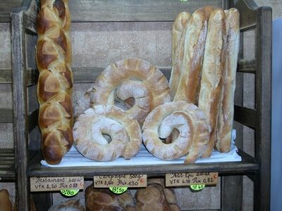
creations. For example, ammonites inspired a small number of partners in shaping
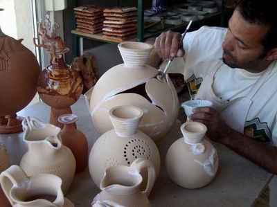
bread (Fig. 9 ![]() ), chocolates and ceramics (Fig.
10
), chocolates and ceramics (Fig.
10 ![]() ).
).
In the past decade, the GeoPark in association with the Pierre
Museum in Digne-les-Bains invited artists to express themselves in the
territory, finding their inspiration in the heritage in the broadest sense:
collections, landscapes, traditions, history, etc. Their work has given rise to
outdoor installations, works displayed in the Musée-Promenade Park and
exhibitions in art galleries. The two best-known artists to have left their mark
in the territory are Andy (Fig.
11 ![]() ) and Hermann de . Although
their work is very different, both share a profound respect for Nature.
) and Hermann de . Although
their work is very different, both share a profound respect for Nature.
At the same time, the Reserve teamed with three other territories in Germany, Spain and Greece and began a European GeoParks initiative that gained support of the UNESCO in 2001. Since then, the Network has been growing and in 2007 counts some 30 territories with many new applicants. Furthermore, this network, using geology and palaeontology to develop a sustainable geotourism, has also been chosen by UNESCO as a model to develop all over the world. This is the birth of the UNESCO Global GeoParks Network in 2004 in Beijing.
From the start, the Reserve, then the GeoPark of Haute-Provence has made remarkable headway in preserving the geological heritage in place and making it accessible to the public. In the early 1980s, the first site museum was dedicated to the Toarcian ichthyosaur of La Robine. Today, five major sites are maintained and physically preserved in place, from the skeletons of sirenians near Castellane to the bird tracks in the Bès Valley. This policy of preservation and display will be pursued in the future.
The first example concerns what may be the most important of all the sites managed by the GeoPark: the ammonite slab, around which a museum will be built after additional study. The purpose of this museum is both to provide the best possible protection against the elements and vandalism, which remains a real threat, and to offer a prestige exhibition site for a unique geological object.
Another perspective for development concerns the use of new technologies to help reveal the geological heritage. In a natural protected area, any alteration made to enhance discovery may be viewed as aggressive adulteration. To date, nonetheless, marking, signs and arrows are essential to guide visitors and provide the information they need and expect. The territory is frequented by more and more city dwellers, but they are increasingly unprepared to function in a natural setting that requires minimum security facilities. Mountain guides provide one solution to this need for assistance in discovering and accessing the wild sites. Today, a third possibility is under development: we are considering, as has already been done in certain pilot programmes (in the Mercantour National Park, for instance), a range of PDA/GPS-assisted tours, which can be updated easily. Such an offering will rely on the GeoPark's network of partners, like the PAIRs (information points).
Thus, with resources and ambitions that adapt over time, the same basic approach remains unchanged: to protect the geological and palaeontological heritage, so it can be preserved in perpetuity to illustrate to people of the future the story of our planet and the life that arose here.
Click on thumbnail to enlarge the image.
Figure 1: Haute-Provence GeoPark is located in the southeastern part of France, in Provence.
Click on thumbnail to enlarge the image.
Figure 2: The city of Digne les Bains is the center of Haute-Provence GeoPark and the department capital. Fossiliferous rocks abound in the region around the city.
Click on thumbnail to enlarge the image.
Figure 3: Upper Jurassic limestones shaped by underwater currents in the Bès valley, north of Digne les Bains.

Click on thumbnail to enlarge the image.
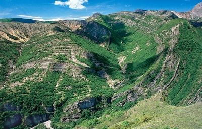
Figure 4: Pic de Couard with cliff and folds in the late Jurassic Tithonian stage limestones.
Click on thumbnail to enlarge the image.
Figure 5: Vélodrome fold, near Barles, in Miocene marine and continental sediments.
Click on thumbnail to enlarge the image.
Figure 6: The ammonite slab at Digne les Bains, with more than 3500 exposed ammonites from the early Jurassic Sinemurian stage, is the most famous fossiliferous site in the GeoPark.
Click on thumbnail to enlarge the image.
Figure 7: In the upper Bléone valley, an ichtyosaur from the upper Cretaceous is preserved and conserved in place. It is protected from man and climate by a wooden shelter.
Click on thumbnail to enlarge the image.
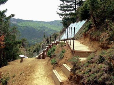
Figure 8: Near Castellane, sirenian fossils are protected beneath covered exhibits so they can be viewed by visitors.
Click on thumbnail to enlarge the image.
Figure 9: Ammonite bread, baked locally in the town of Barrême.
Click on thumbnail to enlarge the image.
Figure 10: Ceramist working with ammonites forms.

Click on thumbnail to enlarge the image.
Figure 11: Andy 's Sentinel in Les Clues de Barles.