![]()
![]()
![]() Bulk rock stable isotope analysis of La Marcouline section (Cassis-La Bédoule area, SE France) revealed a general trend of decreasing δ13C and δ18O values from the bottom to the top of the section. The decrease in δ13C values reflects a global trend in Middle Aptian times, namely a return to pre-excursion values of δ13C values following a major, positive excursion in the Early
Aptian, which is a reflection of the Oceanic Anoxic Event (OAE) 1a.
Bulk rock stable isotope analysis of La Marcouline section (Cassis-La Bédoule area, SE France) revealed a general trend of decreasing δ13C and δ18O values from the bottom to the top of the section. The decrease in δ13C values reflects a global trend in Middle Aptian times, namely a return to pre-excursion values of δ13C values following a major, positive excursion in the Early
Aptian, which is a reflection of the Oceanic Anoxic Event (OAE) 1a.
![]() Power spectra of the bedding rhythms suggest that precessional and long eccentricity cycles of the band controlled the deposition of marl-limestone bundles. This can be interpreted as the result of a forcing by insolation at low latitudes which resulted in a monsoon-controlled precipitation pattern, that in turn induced the deposition of clay-rich beds. Conversely, limestone beds were formed in periods of dryer climate. Higher sea-surface productivity during wet periods may have been caused by an increase in continental runoff and a consequent enhancement in the delivery of nutrients to epicontinental basins.
Power spectra of the bedding rhythms suggest that precessional and long eccentricity cycles of the band controlled the deposition of marl-limestone bundles. This can be interpreted as the result of a forcing by insolation at low latitudes which resulted in a monsoon-controlled precipitation pattern, that in turn induced the deposition of clay-rich beds. Conversely, limestone beds were formed in periods of dryer climate. Higher sea-surface productivity during wet periods may have been caused by an increase in continental runoff and a consequent enhancement in the delivery of nutrients to epicontinental basins.
![]() An orbital cyclicity in the sedimentary patterns in La Marcouline section provides the opportunity to calibrate the duration of the well-established G. ferreolensis foraminiferal Zone with that of orbital chronology. The G. ferreolensis Zone at Cassis-La Bédoule spans 33 precessional cycles and its duration is thus estimated to be approximately 760
ka. This length of time is significantly shorter than the estimates of published timescales for this zone and thus may be an argument for proposing that the Gargasian substage is significantly shorter than its currently accepted range.
An orbital cyclicity in the sedimentary patterns in La Marcouline section provides the opportunity to calibrate the duration of the well-established G. ferreolensis foraminiferal Zone with that of orbital chronology. The G. ferreolensis Zone at Cassis-La Bédoule spans 33 precessional cycles and its duration is thus estimated to be approximately 760
ka. This length of time is significantly shorter than the estimates of published timescales for this zone and thus may be an argument for proposing that the Gargasian substage is significantly shorter than its currently accepted range.
![]() Middle Aptian; Gargasian; stable isotopes; planktonic foraminiferal biostratigraphy; orbitochronology.
Middle Aptian; Gargasian; stable isotopes; planktonic foraminiferal biostratigraphy; orbitochronology.
W. & M. (2007).- The Gargasian (Middle Aptian) of La Marcouline section at Cassis-La Bédoule (SE France): Stable isotope record and orbital cyclicity.- Carnets de Géologie / Notebooks on Geology, Brest, Article 2007/02 (CG2007_A02)
![]() Le Gargasien
(Aptien moyen) de la coupe de La Marcouline à Cassis-La Bédoule (SE
France) : enregistrement des isotopes stables et cyclicité orbitale.-
Une analyse sur roche totale des isotopes stables de la coupe de la carrière
de La Marcouline (secteur de Cassis-La Bédoule, SE de la France) a révélé
une tendance générale à la décroissance des valeurs de δ13C
et δ18O depuis la base jusqu'au sommet de la coupe. La décroissance
des valeurs de δ13C reflète une tendance globale durant
l'Aptien moyen, à savoir un retour à des valeurs inférieures à celles de
l'excursion positive observée à l'Aptien inférieur, qui correspond à l'événement
anoxique océanique OAE1a.
Le Gargasien
(Aptien moyen) de la coupe de La Marcouline à Cassis-La Bédoule (SE
France) : enregistrement des isotopes stables et cyclicité orbitale.-
Une analyse sur roche totale des isotopes stables de la coupe de la carrière
de La Marcouline (secteur de Cassis-La Bédoule, SE de la France) a révélé
une tendance générale à la décroissance des valeurs de δ13C
et δ18O depuis la base jusqu'au sommet de la coupe. La décroissance
des valeurs de δ13C reflète une tendance globale durant
l'Aptien moyen, à savoir un retour à des valeurs inférieures à celles de
l'excursion positive observée à l'Aptien inférieur, qui correspond à l'événement
anoxique océanique OAE1a.
![]() L'analyse
spectrale des rythmes de stratification suggère que les cycles de précession
et les cycles longs d'excentricité de type ont contrôlé le dépôt
des couplets marne-calcaire. Ceci peut s'interpréter comme le résultat d'un
forçage solaire aux basses latitudes qui a engendré un mode de précipitations
contrôlé par la mousson, induisant le dépôt de couches riches en argile. A
l'inverse, les niveaux calcaires se sont déposés durant les périodes de
climat plus sec. La plus forte productivité des eaux de surface durant les périodes
humides peut avoir été causée par un accroissement des apports venant du
continent conduisant à une augmentation des éléments nutritifs au sein des
bassins épicontinentaux.
L'analyse
spectrale des rythmes de stratification suggère que les cycles de précession
et les cycles longs d'excentricité de type ont contrôlé le dépôt
des couplets marne-calcaire. Ceci peut s'interpréter comme le résultat d'un
forçage solaire aux basses latitudes qui a engendré un mode de précipitations
contrôlé par la mousson, induisant le dépôt de couches riches en argile. A
l'inverse, les niveaux calcaires se sont déposés durant les périodes de
climat plus sec. La plus forte productivité des eaux de surface durant les périodes
humides peut avoir été causée par un accroissement des apports venant du
continent conduisant à une augmentation des éléments nutritifs au sein des
bassins épicontinentaux.
![]() La détection
d'une cyclicité orbitale dans les rythmes sédimentaires de la coupe de La
Marcouline fournit l'occasion de calibrer avec la chronologie orbitale la durée de la zone bien caractérisée
par l'espèce de foraminifère planctonique G. ferreolensis.
Dans le secteur de Cassis-La Bédoule cette zone s'étage sur 33 cycles précessionels
et sa durée peut ainsi être estimée à environ 760.000 ans. Cet intervalle de
temps est sensiblement plus bref que les estimations figurant dans certaines échelles
de temps publiées jusqu'à présent pour ladite zone. Cette nouvelle donnée
constitue donc un argument qui autorise à proposer, pour le sous-étage
Gargasien, une durée plus brève que celle qui est admise jusqu'ici.
La détection
d'une cyclicité orbitale dans les rythmes sédimentaires de la coupe de La
Marcouline fournit l'occasion de calibrer avec la chronologie orbitale la durée de la zone bien caractérisée
par l'espèce de foraminifère planctonique G. ferreolensis.
Dans le secteur de Cassis-La Bédoule cette zone s'étage sur 33 cycles précessionels
et sa durée peut ainsi être estimée à environ 760.000 ans. Cet intervalle de
temps est sensiblement plus bref que les estimations figurant dans certaines échelles
de temps publiées jusqu'à présent pour ladite zone. Cette nouvelle donnée
constitue donc un argument qui autorise à proposer, pour le sous-étage
Gargasien, une durée plus brève que celle qui est admise jusqu'ici.
![]() Aptien moyen ; Gargasien ; isotopes stables ; biostratigraphie par foraminifères planctoniques ; orbitochronologie.
Aptien moyen ; Gargasien ; isotopes stables ; biostratigraphie par foraminifères planctoniques ; orbitochronologie.
![]() The Gargasian of the La Marcouline Quarry Section near the Cassis-La Bédoule railway station (SE France) offers a unique opportunity to correlate a precise planktonic foraminiferal zonation ( et alii,
2005) to high-resolution stable oxygen and carbon isotope curves and to an orbital stratigraphy based on well expressed marl-limestone cyclicity. The sections in the Cassis-La Bédoule area are especially well suited to the determination of a high-resolution stratigraphy for the Early-Middle Aptian. Excellent outcrops in which the rate of sedimentation was relatively high and in conjunction with a long-continued, uninterrupted sedimentary pattern are favorable to such an in-depth examination and should enable us to solve some problems in stratigraphic correlation that still exist in spite of extensive study of key sections in Italy and in the Vocontian Basin SE France). In those localities sediments were deposited in deeper water with lower sedimentation rates and may contain hiatuses ( et alii,
1998; et alii, 1999; et alii,
2002). In particular our understanding of the orbital forcing of the Cretaceous carbon isotope record and estimates of the duration of individual carbon isotope excursions may benefit greatly from direct correlation of carbon isotope and sedimentary cycles expressed in fluctuations of carbonate-clay ratios (e.g. et alii,
2005; et alii, 2006, for the Cenomanian-Turonian isotope excursion).
The Gargasian of the La Marcouline Quarry Section near the Cassis-La Bédoule railway station (SE France) offers a unique opportunity to correlate a precise planktonic foraminiferal zonation ( et alii,
2005) to high-resolution stable oxygen and carbon isotope curves and to an orbital stratigraphy based on well expressed marl-limestone cyclicity. The sections in the Cassis-La Bédoule area are especially well suited to the determination of a high-resolution stratigraphy for the Early-Middle Aptian. Excellent outcrops in which the rate of sedimentation was relatively high and in conjunction with a long-continued, uninterrupted sedimentary pattern are favorable to such an in-depth examination and should enable us to solve some problems in stratigraphic correlation that still exist in spite of extensive study of key sections in Italy and in the Vocontian Basin SE France). In those localities sediments were deposited in deeper water with lower sedimentation rates and may contain hiatuses ( et alii,
1998; et alii, 1999; et alii,
2002). In particular our understanding of the orbital forcing of the Cretaceous carbon isotope record and estimates of the duration of individual carbon isotope excursions may benefit greatly from direct correlation of carbon isotope and sedimentary cycles expressed in fluctuations of carbonate-clay ratios (e.g. et alii,
2005; et alii, 2006, for the Cenomanian-Turonian isotope excursion).
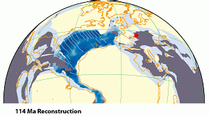
![]() The studied section is situated close to the European continental block
(Fig. 1
The studied section is situated close to the European continental block
(Fig. 1 ![]() ), namely in the South Provencal Basin, which is located within the Provence carbonate platform and is not far from the adjacent Vocontian Basin (see et alii,
2004; & ,
2004, for more details on the geographic location and geological setting). These are key areas for understanding the relationships between Cretaceous climate, nutrient fluxes, productivity and carbon fluxes from the continent or the carbonate platforms to the open ocean (,
1997; et alii,
1998; et alii,
2003). Moreover, the section is located in an area of potentially high sensitivity to variability in precessional insolation in the Cretaceous like that of the U.S. Western Interior Seaway and that of the archipelago along the northwestern margin of the Tethys
(Fig. 1
), namely in the South Provencal Basin, which is located within the Provence carbonate platform and is not far from the adjacent Vocontian Basin (see et alii,
2004; & ,
2004, for more details on the geographic location and geological setting). These are key areas for understanding the relationships between Cretaceous climate, nutrient fluxes, productivity and carbon fluxes from the continent or the carbonate platforms to the open ocean (,
1997; et alii,
1998; et alii,
2003). Moreover, the section is located in an area of potentially high sensitivity to variability in precessional insolation in the Cretaceous like that of the U.S. Western Interior Seaway and that of the archipelago along the northwestern margin of the Tethys
(Fig. 1 ![]() ) (,
2001).
) (,
2001).
![]() Here we present a first bed-resolution carbon isotope stratigraphy and cyclostratigraphy of the Gargasian at La Marcouline, which is integrated with previously published biostratigraphic and chemostratigraphic records ( et alii,
2004, 2005), to investigate the potential of this section for future, millennial-scale studies of Aptian climate variability and orbital forcing.
Here we present a first bed-resolution carbon isotope stratigraphy and cyclostratigraphy of the Gargasian at La Marcouline, which is integrated with previously published biostratigraphic and chemostratigraphic records ( et alii,
2004, 2005), to investigate the potential of this section for future, millennial-scale studies of Aptian climate variability and orbital forcing.
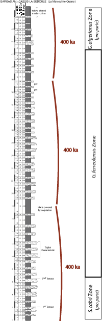
![]() We sampled the lower and middle Gargasian beds of the La Marcouline Quarry section near the Cassis-La Bédoule railway station
(Fig. 2
We sampled the lower and middle Gargasian beds of the La Marcouline Quarry section near the Cassis-La Bédoule railway station
(Fig. 2 ![]() ). The lowermost Gargasian could not be properly sampled in this section, for an interval of approximately 5 m, straddling the Bedoulian-Gargasian transition, is there covered by a road and by vegetation ( et alii,
2004). The upper part of the Gargasian is missing, due to pre-Cenomanian erosion that affected the entire area.
). The lowermost Gargasian could not be properly sampled in this section, for an interval of approximately 5 m, straddling the Bedoulian-Gargasian transition, is there covered by a road and by vegetation ( et alii,
2004). The upper part of the Gargasian is missing, due to pre-Cenomanian erosion that affected the entire area.
![]() A total of 91 bulk-rock samples from the light grey micritic limestones and grey clay-rich marlstones of La Marcouline section have been analyzed for stable oxygen and carbon isotopes. The relative positions of samples in the composite section according to bed numbers and thickness in meters are given in
Figure 2
A total of 91 bulk-rock samples from the light grey micritic limestones and grey clay-rich marlstones of La Marcouline section have been analyzed for stable oxygen and carbon isotopes. The relative positions of samples in the composite section according to bed numbers and thickness in meters are given in
Figure 2 ![]() . Sampled lithologies include homogeneous micritic limestones
(nanno-ooze) apparently without significant amounts of late diagenetic cementation, marly limestones and marls ( et alii,
2007). Samples taken from freshly cut rock slabs were crushed and carefully homogenized in an agate mortar. Isotopic measurements were made with a Finnigan MAT 251 mass spectrometer installed at the
Leibniz-Labor für Altersbestimmung und Isotopenforschung in Kiel. The instrument is coupled on-line to a
Carbo-Kiel device for automated CO2 preparation from carbonate samples for isotopic analysis. CO2 was generated by the addition of orthophosphoric acid to each sample. Measurements have an accuracy of ± 0.057‰ for carbon and ± 0.084‰ for oxygen isotopes. The results were calibrated using the National Institute Bureau of Standards and Technology (Gaithersburg, Maryland), carbonate isotope standard NBS 20 and, in addition, NBS 19 and 18 and are reported on the Vienna PeeDee belemnite
(VPDB) scale.
. Sampled lithologies include homogeneous micritic limestones
(nanno-ooze) apparently without significant amounts of late diagenetic cementation, marly limestones and marls ( et alii,
2007). Samples taken from freshly cut rock slabs were crushed and carefully homogenized in an agate mortar. Isotopic measurements were made with a Finnigan MAT 251 mass spectrometer installed at the
Leibniz-Labor für Altersbestimmung und Isotopenforschung in Kiel. The instrument is coupled on-line to a
Carbo-Kiel device for automated CO2 preparation from carbonate samples for isotopic analysis. CO2 was generated by the addition of orthophosphoric acid to each sample. Measurements have an accuracy of ± 0.057‰ for carbon and ± 0.084‰ for oxygen isotopes. The results were calibrated using the National Institute Bureau of Standards and Technology (Gaithersburg, Maryland), carbonate isotope standard NBS 20 and, in addition, NBS 19 and 18 and are reported on the Vienna PeeDee belemnite
(VPDB) scale.
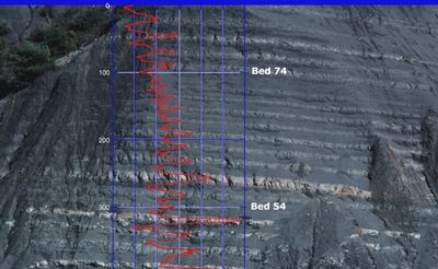
![]() Spectral analyses were made using field measurements of the section. The sediments were classified into four different lithologies (limestones, marly limestones, calcareous marlstones, and marlstones). These lithologies correspond well with grey values derived from photographs of the outcrops. Grey scale values were obtained from scanned color photographs, taken in the late afternoon, when light conditions permitted shadow-free images of the outcrop surface. Grey scale curves were generated for well-exposed parts of the section using NIH Image software
(Fig. 3
Spectral analyses were made using field measurements of the section. The sediments were classified into four different lithologies (limestones, marly limestones, calcareous marlstones, and marlstones). These lithologies correspond well with grey values derived from photographs of the outcrops. Grey scale values were obtained from scanned color photographs, taken in the late afternoon, when light conditions permitted shadow-free images of the outcrop surface. Grey scale curves were generated for well-exposed parts of the section using NIH Image software
(Fig. 3 ![]() ). Input data for spectral analysis were based on (1) the thickness of strata measured in the outcrop and (2) a classification by the quantity of carbonate in individual samples grouped into four classes based on the carbonate values of individual samples as related to the
grey-scale value of the sediment. power spectra were generated from marl limestone bedding rhythms and carbonate content estimations using Analyserie 1.2 ( et alii,
1996).
). Input data for spectral analysis were based on (1) the thickness of strata measured in the outcrop and (2) a classification by the quantity of carbonate in individual samples grouped into four classes based on the carbonate values of individual samples as related to the
grey-scale value of the sediment. power spectra were generated from marl limestone bedding rhythms and carbonate content estimations using Analyserie 1.2 ( et alii,
1996).
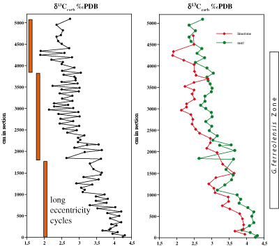
![]() Bulk rock stable isotope analysis of the la Marcouline section revealed a general trend of decreasing δ13C values from more than 4‰ at the bottom to approximately 2.5‰ at the top of the section
(Fig. 4
Bulk rock stable isotope analysis of the la Marcouline section revealed a general trend of decreasing δ13C values from more than 4‰ at the bottom to approximately 2.5‰ at the top of the section
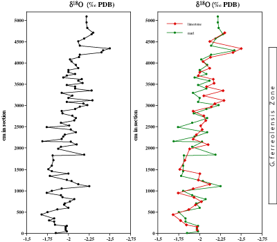
(Fig. 4 ![]() ). This trend is paralleled by a decrease in δ18O values, that probably indicates either a warming trend or a freshening of surface waters
(Fig. 5
). This trend is paralleled by a decrease in δ18O values, that probably indicates either a warming trend or a freshening of surface waters
(Fig. 5 ![]() ). The decrease in δ13C values reflects the Middle Aptian return to pre-excursion values after the major positive excursion in the Early
Aptian, which reflects the Oceanic Anoxic Event (OAE) 1a
(Fig. 6
). The decrease in δ13C values reflects the Middle Aptian return to pre-excursion values after the major positive excursion in the Early
Aptian, which reflects the Oceanic Anoxic Event (OAE) 1a
(Fig. 6 ![]() )
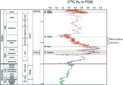
( et alii,
1998; et alii, 1998). From approximately 30 m to 50 m the δ13C values stay almost constant at 2.2-2.5‰ for limestone and 2.5-2.8‰ for marls. This interval probably corresponds to a δ13C plateau with values of approximately 2.2‰ δ13C in the upper part of the G. ferreolensis Zone observed in previous studies in the Vocontian Basin ( et alii,
2004; et alii,
2006)
(Fig. 6
)
( et alii,
1998; et alii, 1998). From approximately 30 m to 50 m the δ13C values stay almost constant at 2.2-2.5‰ for limestone and 2.5-2.8‰ for marls. This interval probably corresponds to a δ13C plateau with values of approximately 2.2‰ δ13C in the upper part of the G. ferreolensis Zone observed in previous studies in the Vocontian Basin ( et alii,
2004; et alii,
2006)
(Fig. 6 ![]() ). The second decrease in δ13C, that culminates in minimum values between 1.0 and 1.5‰ in the Niveau Fallot of the Vocontian sections, is not recorded in La Marcouline section, for this event starts significantly above the FO of G. algerianus and only the first five meters of the G. algerianus Zone crop out in La Marcouline section.
). The second decrease in δ13C, that culminates in minimum values between 1.0 and 1.5‰ in the Niveau Fallot of the Vocontian sections, is not recorded in La Marcouline section, for this event starts significantly above the FO of G. algerianus and only the first five meters of the G. algerianus Zone crop out in La Marcouline section.
![]() Marl and limestone layers differ significantly in δ13C values
(Fig. 4
Marl and limestone layers differ significantly in δ13C values
(Fig. 4 ![]() ). Generally, the δ13C values of limestones are approximately 0.5‰ lower than those of marls. This difference might be explained by an early diagenetic cementation of limestones, causing pore water with a lower δ13C value to have a greater effect on the limestone deposits. However, there is no significant difference in the δ18O values of marls and limestones
(Fig. 5
). Generally, the δ13C values of limestones are approximately 0.5‰ lower than those of marls. This difference might be explained by an early diagenetic cementation of limestones, causing pore water with a lower δ13C value to have a greater effect on the limestone deposits. However, there is no significant difference in the δ18O values of marls and limestones
(Fig. 5 ![]() ); this suggests that the differences in carbon isotopes are a primary signal and are not caused by cementation on the sea floor or during burial.
A better explanation for the observed difference in the δ13C values of limestone and marl may involve an increase in sea surface productivity triggered by an enhanced nutrient input caused by a more important continental runoff during the deposition of clay. This might have caused the "biological pump" to be more active during periods of clay sedimentation.
); this suggests that the differences in carbon isotopes are a primary signal and are not caused by cementation on the sea floor or during burial.
A better explanation for the observed difference in the δ13C values of limestone and marl may involve an increase in sea surface productivity triggered by an enhanced nutrient input caused by a more important continental runoff during the deposition of clay. This might have caused the "biological pump" to be more active during periods of clay sedimentation.
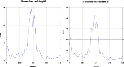
![]() power spectra of the marl-limestone rhythms exhibit significant peaks at a frequency of 0.01 cycles/cm (wavelength of approximately 1 m) and 0.0005 cycles/cm (wavelength of 20 m)
(Fig. 7
power spectra of the marl-limestone rhythms exhibit significant peaks at a frequency of 0.01 cycles/cm (wavelength of approximately 1 m) and 0.0005 cycles/cm (wavelength of 20 m)
(Fig. 7 ![]() ). The high frequency cycles coincide with the apparent marl / limestone couplets and may be explained by precessional cycles controlling the intensity of precipitation and continental runoff ( & ,
1984; , 2001; & ,
2006). The low frequency cycles apparently correspond to the 400 ka long eccentricity cycles that modulate the precession
(Fig. 8
). The high frequency cycles coincide with the apparent marl / limestone couplets and may be explained by precessional cycles controlling the intensity of precipitation and continental runoff ( & ,
1984; , 2001; & ,
2006). The low frequency cycles apparently correspond to the 400 ka long eccentricity cycles that modulate the precession
(Fig. 8 ![]() ). The absence of 100 ka short eccentricity "bundles", a common feature in other lower Cretaceous marl-limestone cycles (e.g. in the Piobbico core, et alii,
1991) is somewhat surprising. A possible explanation could be an orbital configuration with a normal amplitude of the long (400 ka) eccentricity cycle, but a low amplitude of the short (100 ka) eccentricity cycle. Such a configuration can last over two long eccentricity cycles and normally occurs every 2.4 Ma ( et alii,
2004). However, the orbital solution of et alii
(2004) goes back only 100 Ma, and the possibility of a node in the 100 ka periodicity of the earth's eccentricity in the Gargasian can be verified only when an orbital solution extending back to 120 Ma becomes available.
). The absence of 100 ka short eccentricity "bundles", a common feature in other lower Cretaceous marl-limestone cycles (e.g. in the Piobbico core, et alii,
1991) is somewhat surprising. A possible explanation could be an orbital configuration with a normal amplitude of the long (400 ka) eccentricity cycle, but a low amplitude of the short (100 ka) eccentricity cycle. Such a configuration can last over two long eccentricity cycles and normally occurs every 2.4 Ma ( et alii,
2004). However, the orbital solution of et alii
(2004) goes back only 100 Ma, and the possibility of a node in the 100 ka periodicity of the earth's eccentricity in the Gargasian can be verified only when an orbital solution extending back to 120 Ma becomes available.
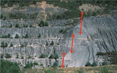
![]() The G. ferreolensis Zone in La Marcouline section is comprised between the last occurence of Schackoina cabri, observed in bed 15 at 6 m, and the first occurrence of G. algerianus, in bed 84 (43.05 m). Our results show that the duration of the G. ferreolensis Zone is approximately 33 precessional cycles (760 ka) or slightly less than two long eccentricity (400 ka) cycles
(Figs. 1
The G. ferreolensis Zone in La Marcouline section is comprised between the last occurence of Schackoina cabri, observed in bed 15 at 6 m, and the first occurrence of G. algerianus, in bed 84 (43.05 m). Our results show that the duration of the G. ferreolensis Zone is approximately 33 precessional cycles (760 ka) or slightly less than two long eccentricity (400 ka) cycles
(Figs. 1 ![]() & 8
& 8 ![]() ). The two foraminiferal bio-events mentioned above are dated 120.7 Ma and 119.0 Ma, respectively, in the et alii
(2004) timescale, that is 1.7 Ma for the G. ferreolensis Zone. Thus, based on our work
(< circa 0.8 Ma) the duration of the G. ferreolensis Zone appears to be significantly shorter than the 1.7 Ma reported in the et alii
(2004) timescale.
). The two foraminiferal bio-events mentioned above are dated 120.7 Ma and 119.0 Ma, respectively, in the et alii
(2004) timescale, that is 1.7 Ma for the G. ferreolensis Zone. Thus, based on our work
(< circa 0.8 Ma) the duration of the G. ferreolensis Zone appears to be significantly shorter than the 1.7 Ma reported in the et alii
(2004) timescale.
![]() The dominant frequency in power spectra of carbonate and bedding is 0.01 cycles/cm; this corresponds to a wavelength of approximately 100 cm, which results in a sedimentation rate of
circa 4.3 cm/ka, significantly higher than the sedimentation rate calculated from the et alii
(2004) timescale (2.2 cm/ka, 37 m corresponding to 1.7 Ma). Using that scale, the duration of the main cycle in La Marcouline section would be 45 ka. However, the duration of the Aptian stage and its substages is controversial. Recent estimates of the length of the Aptian, made by combining radiometric (K-Ar ages of glauconite) and orbital chronology, suggest a duration of only 6.8 ± 0.4 Ma ( et alii,
2006), i.e. half of that suggested by et alii
(2004) (13.0 ± 2.0 Ma) (Table 1). The use of the recent time scale of ( et alii,
2006) leads to the calculation of the length of the dominant period of La Marcouline section as 23 ka (in agreement with orbital precession) rather than 45 ka.
The dominant frequency in power spectra of carbonate and bedding is 0.01 cycles/cm; this corresponds to a wavelength of approximately 100 cm, which results in a sedimentation rate of
circa 4.3 cm/ka, significantly higher than the sedimentation rate calculated from the et alii
(2004) timescale (2.2 cm/ka, 37 m corresponding to 1.7 Ma). Using that scale, the duration of the main cycle in La Marcouline section would be 45 ka. However, the duration of the Aptian stage and its substages is controversial. Recent estimates of the length of the Aptian, made by combining radiometric (K-Ar ages of glauconite) and orbital chronology, suggest a duration of only 6.8 ± 0.4 Ma ( et alii,
2006), i.e. half of that suggested by et alii
(2004) (13.0 ± 2.0 Ma) (Table 1). The use of the recent time scale of ( et alii,
2006) leads to the calculation of the length of the dominant period of La Marcouline section as 23 ka (in agreement with orbital precession) rather than 45 ka.
| Base of Gargasian: |
et alii, 2004: |
|
et alii, 2006: |
|
| Top of Gargasian: |
et alii, 2004: |
|
et alii, 2006: |
|
| Duration of Gargasian: |
et alii, 2004: |
|
et alii, 2006: |
Table 1: Age estimates of the base, top and duration of the Gargasian substage after et alii (2004) and et alii (2006).
![]() The La Marcouline section, located in the Lower Aptian historical stratotype area, provides an unusual opportunity to calibrate the duration of a well-established Gargasian foraminiferal biozone with orbital chronology. The G. ferreolensis Zone spans 33 precessional cycles and its duration can thus be calculated as approximately 760 ka. This length is significantly shorter than the estimate for this zone by et alii
(2004), and may be an argument in favour of a significantly shorter Aptian stage as recently proposed by et alii
(2006).
The La Marcouline section, located in the Lower Aptian historical stratotype area, provides an unusual opportunity to calibrate the duration of a well-established Gargasian foraminiferal biozone with orbital chronology. The G. ferreolensis Zone spans 33 precessional cycles and its duration can thus be calculated as approximately 760 ka. This length is significantly shorter than the estimate for this zone by et alii
(2004), and may be an argument in favour of a significantly shorter Aptian stage as recently proposed by et alii
(2006).
![]() The carbon isotope stratigraphy of the lower Gargasian at La Marcouline is very similar to its records in the Vocontian trough ( et alii,
2004; et alii,
2006). This underlines the importance of carbon isotope stratigraphy for regional and global correlation of stratigraphic successions.
The carbon isotope stratigraphy of the lower Gargasian at La Marcouline is very similar to its records in the Vocontian trough ( et alii,
2004; et alii,
2006). This underlines the importance of carbon isotope stratigraphy for regional and global correlation of stratigraphic successions.
![]() Isotope analyses were performed at the Leibniz-Labor für Altersbestimmung und Isotopenforschung at Kiel University by Helmut and his group. We thank Jean-Pierre and Maurice for the joint field work at La Marcouline quarry and Brigitte (Kiel) for sample processing. We thank also two reviewers, Karl and
Emmanuela , who provided helpful comments that improved the manuscript, as well as Nestor for corrections of syntax and word choice that improved the readability of the text.
Isotope analyses were performed at the Leibniz-Labor für Altersbestimmung und Isotopenforschung at Kiel University by Helmut and his group. We thank Jean-Pierre and Maurice for the joint field work at La Marcouline quarry and Brigitte (Kiel) for sample processing. We thank also two reviewers, Karl and
Emmanuela , who provided helpful comments that improved the manuscript, as well as Nestor for corrections of syntax and word choice that improved the readability of the text.
C., M. de, M., M. & G. (2007).- Environmental changes during marl-limestone formation: evidence from the Gargasian (Middle Aptian) of La Marcouline Quarry (Cassis, SE France).- Carnets de Géologie / Notebooks on Geology, Brest, Article 2007/01 (CG2007_A01), 13 p.
J.G. (1997).- L'Aptien et l'Albien de la fosse vocontienne (des bordures au bassin) : Évolution de la sédimentation et enseignements sur les événements anoxiques.- Mémoires de la Société géologique du Nord, Lille, vol. 25, 164 p.
P. & M. (1984).- Cyclic sedimentation in the Cretaceous of Deep Sea Drilling Project Sites 535 and 540 (Gulf of Mexico), 534 (central Atlantic) and in the Vocontian Basin (France).- Deep Sea Drilling Project, Initial Reports, Washington D.C., vol. 77, p. 339-376.
E., J.E.T., M., C., R., B., I., A., G. & S. (1999).- Integrated stratigraphy of the Cismon Apticore (southern Alps, Italy): A "reference section" for the Barremian-Aptian interval at low latitudes.- Journal of Foraminiferal Research, Lawrence, vol. 29, p. 371-391.
N., X., O., L.G. & P.Y. (2006).- Lower Cretaceous stage durations combining radiometric data and orbital chronology: Towards a more stable relative time scale?- Earth and Planetary Science Letters, Amsterdam, vol. 246, n° 3-4, p. 407-417.
A.G., T.D., G., I. & M. (1991).- Albian pelagic rhythms (Piobbico Core).- Journal of Sedimentary Research, Boulder, vol. 61, p. 1164-1172.
S. (2001).- On the influence of precessional cycles on the Late Cretaceous Climate System: Comparison of GCM_results, geochemical, and sedimentary proxies for the western Interior Seaway of North America.- Doctoral Thesis, Christian-Albrechts-University of Kiel, Germany, 236 p.
S. & T. (2006).- Insolation-control on the Late Cretaceous hydrological cycle and tropical African climate-global climate modelling linked to marine climate records.- Palaeogeography, Palaeoclimatology, Palaeoecology, Amsterdam, vol. 235, n° 1-3, p. 288-304.
K.B., A., S. & P. (2006).- Interactions between environmental change and shallow water carbonate buildup along northern Tethyan margin and their impact on the Early Cretaceous carbon isotope record.- Paleoceanography, Washington D.C., vol. 21, n° 4, PA4211, doi: 10.1029/2006PA001313
A., S., K.B., J., S., N., T., B., D. & B. (2006).- Evolution of the marine stable carbon-isotope record during the Early Cretaceous: A focus on the Late Hauterivian and Barremian in the Tethyan realm.- Earth and Planetary Science Letters, Amsterdam, vol. 242, n° 3-4, p. 254-271.
W.W., R., C.N., K.M., S., M., A., W.-C., A.B., A.N. & E. (1999).- Alternative global Cretaceous paleogeography.- In: E. & C. (eds.), The evolution of Cretaceous ocean/climate systems.- Geological Society of America, Special Paper, n° 332, p. 1-47.
J.O., P., O., H. & C. (2004).- High-resolution carbon isotope records of the Aptian to lower Albian from SE France and the Mazagan Plateau (DSDP Site 545): A stratigraphic tool for paleoceanographic and paleobiologic reconstruction.- Earth and Planetary Science Letters, Amsterdam, vol. 218, n° 1-2, p. 149-161.
W., M., J.-P. & H. (1998).- Carbon isotope stratigraphy of the lower Aptian historical stratotype at Cassis-La Bédoule (S.E. France).- Géologie Méditerranéenne, Marseille, t. XXV, n° 3-4, p. 63-79.
J., P., F., M., A.C.M. & B. (2004).- A long term numerical solution for the insolation quantities of the Earth.- Astronomy and Astrophysics, Paris, vol. 428, n° 1, p. 261-285.
A.P., H., R.S., R.V., P., A. & M. (1998).- High-resolution δ13C stratigraphy through the Early Aptian "Livello Selli" of the Alpine Tethys-. Paleoceanography, Washington D.C., vol. 13, n° 5, p. 530-545.
M. & G. (2004).- The Gargasian (Middle Aptian) substage in the Aptian historical stratotypes (SE France): General introduction.- Carnets de Géologie / Notebooks on Geology, Maintenon, Letter 2004/01 (CG2004_L01), 3 p.
M., W., J.A., J.-P. & G. (1998).- Correlation of biostratigraphic and stable isotope events in the Aptian historical stratotype of La Bédoule (southeast France).- Comptes Rendus de l'Académie des Sciences, Paris, (Série IIa, Sciences de la Terre et des Planètes), n° 327, p. 693- 698.
M., G., W., M. & J.-P. (2004).- The Gargasian (Middle Aptian) of Cassis-La Bédoule (Lower Aptian historical stratotype, SE France): Geographic location and lithostratigraphic correlations.- Carnets de Géologie / Notebooks on Geology, Maintenon, Letter 2004/02 (CG2004_L02), 4 p.
M., G., J.-P. (2005).- The Gargasian (Middle Aptian) strata from Cassis-La Bédoule (Lower Aptian historical stratotype, SE France): planktonic and benthic foraminiferal assemblages and biostratigraphy.- Carnets de Géologie / Notebooks on Geology, Brest, Article 2005/02 (CG2005_A02), 20 p.
J.G., F.P. & F.M. (2004).- The Cretaceous Period. In: F., J. & A. (eds.), A geologic time scale 2004.- Cambridge University Press, p. 344-383.
D., L. & P.
(1996).- Macintosh program performs time-series analysis.- Eos, Transactions, American Geophysical Union, Electronic Supplement, Washington D.C., vol. 77, n° 39, p. 379
[http://www.agu.org/eos_elec/96097e.html].
A.G., D.G. & B.M. (1994).- Atlas of Mesozoic and Cenozoic coastlines.- Cambridge University Press, 99 p.
B.B., S.R. & M.A. (2006).- Orbital time scale and new C-isotope record for Cenomanian- Turonian boundary stratotype.- Geology, Boulder, vol. 34, n° 2, p. 125-128.
H., A., K.B. & O. (1998).- Correlation of Early Cretaceous carbon isotope stratigraphy and platform drowning events: A possible link?- Palaeogeography, Palaeoclimatology, Palaeoecology, Amsterdam, vol. 137, n° 3, p. 189-203.
L., H., J.-P. & L.G. (2002).- Chemostratigraphic correlation of Barremian and lower Aptian ammonite zones and magnetic reversals.- International Journal of Earth Sciences (Geologische Rundschau), Stuttgart, vol. 91, n° 2, p. 272- 279.
L.H., H. & H. (2003).- Response of Early Cretaceous carbonate platforms to changes in atmospheric carbon dioxide levels.- Palaeogeography, Palaeoclimatology, Palaeoecology, Amsterdam, vol. 200, n° 1-4, p. 187- 205.
Click on thumbnail to enlarge the image.
Figure 1: Middle-Late Aptian (114 Ma) paleogeographic reconstruction based on the finite rotation dataset published by et alii
(1999) and available on the ODSN website
(http://www.odsn.de/odsn/services/paleomap/paleomap.html).
The sketched shoreline was taken from et alii
(1994). Position of the La Marcouline Section is indicated by
red dot within a NW Tethys marginal basin.
Click on thumbnail to enlarge the image.
Figure 2: Log of the La Marcouline Quarry Section with sample positions and bed thicknesses used for spectral analyses. The main 400 ka long eccentricity cycles and the boundaries of planktonic foraminiferal zones are indicated.
Click on thumbnail to enlarge the image.
Figure 3: Outcrop photograph overlain by greyscale values generated by NIH Image analysis of digitalized color slides.
Click on thumbnail to enlarge the image.
Figure 4: Carbonate carbon isotope curve of the La Marcouline section.
Click on thumbnail to enlarge the image.
Figure 5: Carbonate oxygen isotope curve of the La Marcouline section.
Click on thumbnail to enlarge the image.
Figure 6: Composite carbonate carbon isotope curve of the Vocontian realm and the Cassis-La Bédoule area, modified after et alii (2006). Data represented by green dots are from et alii (2006), data in blue are from et alii (1998), and data in red are from et alii (2004). Timescale is according to et alii (2004).
Click on thumbnail to enlarge the image.
Figure 7: power spectra of bedding rhythm (left graph) and carbonate content measurements (right graph). Band width = 0.001013, 0.625180 < ΔP (80.000000 %) / P < 2.057926.
Click on thumbnail to enlarge the image.
Figure 8: Outcrop photograph of the La Marcouline Quarry Section. The main 400 ka long eccentricity cycles are indicated.