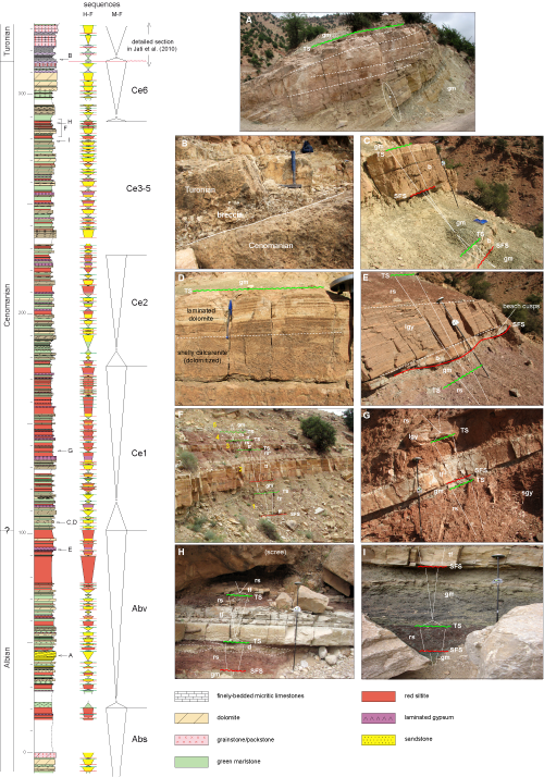
◄ Carnets Geol. 15 (12) ►
![]()
Contents
[1. Introduction]
[2. Materials and methods]
[3. Palaeogeographic context]
[4. Description and sequence stratigraphic interpretation of the
sections]
[5. West-East correlations] [6. Depositional model
for Cenomanian sequences]
[7. Discussion] [8. Conclusions] and ... [Bibliographic references]
UniversitÚ Ibn Zohr, Laboratoire de GÚologie AppliquÚe et
GÚo Environnement (LAGAGE), DÚpartement de GÚologie, FacultÚ des Sciences,
BP 81106, CitÚ Dakhla, 8000 Agadir (Maroc);
present address : UniversitÚ Moulay Ismail, FacultÚ des Sciences et
Techniques, DÚpartement de GÚologie, BP 509, 52000 Errachidia (Maroc)
6D, avenue GÚnÚral de Gaulle, 05100 Brianþon (France)
UniversitÚ de Lorraine, FacultÚ des Sciences et Technologies, DÚpartement
des GÚosciences, UMR CNRS 7359 GÚoRessources, BP 70239, 54506 Vandoeuvre-lÞs-Nancy (France)
UniversitÚ Ibn Zohr, Laboratoire de GÚologie AppliquÚe et
GÚo Environnement (LAGAGE), DÚpartement de GÚologie, FacultÚ des Sciences,
BP 81106, CitÚ Dakhla, 8000 Agadir (Maroc)
UniversitÚ Ibn Zohr, Laboratoire de GÚologie AppliquÚe et
GÚo Environnement (LAGAGE), DÚpartement de GÚologie, FacultÚ des Sciences,
BP 81106, CitÚ Dakhla, 8000 Agadir (Maroc)
UniversitÚ Ibn Zohr, Laboratoire de GÚologie AppliquÚe et
GÚo Environnement (LAGAGE), DÚpartement de GÚologie, FacultÚ des Sciences,
BP 81106, CitÚ Dakhla, 8000 Agadir (Maroc)
UniversitÚ de Provence, FRE CNRS 2761 GÚologie des SystÞmes CarbonatÚs,
13331 Marseille Cedex (France)
UniversitÚ de Lorraine, École Nationale SupÚrieure de GÚologie, UMR
CNRS 7359 GÚoRessources, CREGU, BP 70605 Vandoeuvre-lÞs-Nancy Cedex (France)
UniversitÚ Ibn Zohr, Laboratoire de GÚologie AppliquÚe et
GÚo Environnement (LAGAGE), DÚpartement de GÚologie, FacultÚ des Sciences,
BP 81106, CitÚ Dakhla, 8000 Agadir (Maroc)
Published online in final form (pdf) on August 6, 2015
[Editor: Bruno ; language editor:
Phil ]
![]()
Seven sections, covering the upper Albian to lowermost Turonian, have been correlated from full-marine to continental-dominated deposits across a passive margin, along a transect 425 km long, from the present-day Atlantic coast to the "Pre-African Trough" between the Anti-Atlas and the High-Atlas. The thickness of the Cenomanian succession changes from around 500 metres in the fully marine sections to 250 metres in mostly continental facies in the western High-Atlas, about 150 km updip, to a few tens of metres in the Bou Tazoult area. The strata thicken again eastwards into the Pre-African Trough where they can be traced without major facies changes to the Kem Kem embayment and to the Bechar area in Algeria. Over all this eastern area, continental facies are overlain by the fully-marine shallow-water deposits of the Cenomanian-Turonian boundary interval.
A first major conclusion is that fluvial aggradation in high-frequency transgressive-regressive sequences is coeval with the seaward-shift of the shoreline, in accordance with the genetic sequence stratigraphic model of (1989). Both the flatness of the depositional profile and the corresponding very low energy of the marine environment during the transgressions account for the blanket of red continental clays on top of marine facies in updip depositional sequences, which is then preserved under the marine transgressive surface of the next sequence.
A second major conclusion is that the high-frequency transgressive-regressive (T-R) sequences do not look like classical parasequences bounded by transgression surfaces. They usually exhibit a surface created by a sea-level fall within the regressive half-cycle. This is interpreted in the following way: regressions did not operate through a regular seaward-shift of the shoreline, but through stepped sea-level falls. The very low slope of the depositional ramp is thought to have enhanced the sequence stratigraphic record of such stepped regressions. Short-term, high-frequency sequences are organized into medium-frequency T-R sequences (seven in the Cenomanian) which show an overall aggrading and slowly retrograding pattern along the whole transect.
Comparisons with other basins show that medium-frequency sequences do not fit the third-order depositional sequences described elsewhere, casting doubts about a eustatic mechanism for their deposition.
Morocco; Cenomanian; fluvial aggradation; fluvial-marine transition; sequence stratigraphy.
B., S., D., N., H., M., L.G., Y. &M. (2015).- Sequence stratigraphic architecture of marine to fluvial deposits across a passive margin (Cenomanian, Atlantic margin, Morocco, Agadir transect).- Carnets Geol., Madrid, vol. 15, nº 12, p. 137-172.
Architecture sÚquentielle des dÚp¶ts marins Ó continentaux sur une marge passive (CÚnomanien, marge Atlantique marocaine, transversale d'Agadir).- Sept coupes couvrant l'intervalle Albien supÚrieur-Turonien infÚrieur ont ÚtÚ corrÚlÚes sur plus de 400 km, des faciÞs entiÞrement marins jusqu'aux dÚp¶ts presque exclusivement continentaux, depuis la c¶te atlantique et le sillon prÚ-africain, entre le Haut-Atlas et l'Anti-Atlas marocains. L'Úpaisseur des dÚp¶ts cÚnomaniens varie d'environ 500 m dans les sÚries entiÞrement marines de la c¶te actuelle, Ó 250 m dans les sÚries principalement continentales du Haut-Atlas, pour s'amincir Ó quelques dizaines de mÞtres (Bou Tazoult), sur environ 250 km. La sÚrie s'Úpaissit Ó nouveau vers l'est dans le sillon prÚ-africain o¨ elle peut Ûtre suivie sans changements notables vers le golfe des Kem-Kem et le secteur de BÚchar en AlgÚrie. Sur toute la partie orientale de la transversale, les faciÞs continentaux ou mixtes sont recouverts par les dolomies marines du passage CÚnomanien-Turonien.
Une premiÞre conclusion majeure est que, dans les sÚquences transgression-rÚgression (T-R) Ó haute frÚquence, l'aggradation fluviatile accompagne sans hiatus le dÚplacement de la ligne de rivage au cours du demi-cycle rÚgressif, en accord avec le modÞle gÚnÚtique de (1989). La platitude extrÛme du profil de dÚp¶t ainsi que la faible Únergie correspondante de l'environnement marin expliquent la prÚservation de la faible couche de dÚp¶ts continentaux rouges de fin de sÚquence au cours de la transgression suivante.
Une seconde observation majeure est que ces sÚquences T-R Ó haute frÚquence ne sont pas organisÚes comme les "parasÚquences" du modÞle de stratigraphie sÚquentielle "d'Exxon", en principe limitÚes les unes des autres par des surfaces de transgression. Elles comportent toutes en plus une surface de chute du niveau marin relatif dans le demi-cycle rÚgressif. Ceci est interprÚtÚ de la faþon suivante : les rÚgressions de la ligne de rivage ne sont jamais rÚguliÞres, elles s'effectuent par l'intermÚdiaire de chutes ÚtagÚes qui embo¯tent vers l'aval les prismes c¶tiers successifs. LÓ encore, la pente extrÛmement faible du profil de dÚp¶t explique la distorsion gÚomÚtrique de l'enregistrement stratigraphique du demi-cycle rÚgressif. Les sÚquences Ó haute frÚquence sont organisÚes en sÚquences T-R Ó moyenne frÚquence dont l'empilement au cours du CÚnomanien est globalement aggradant-lentement rÚtrogradant sur la transversale.
La comparaison avec d'autres bassins montre que les sÚquences Ó moyenne frÚquence ne correspondent pas aux sÚquences de 3º ordre dÚcrites ailleurs, mettant ainsi en doute un mÚcanisme eustatique pour leur mise en place.
Maroc ; CÚnomanien ; aggradation fluviatile ; transition fluviatile-marin ; stratigraphie sÚquentielle.
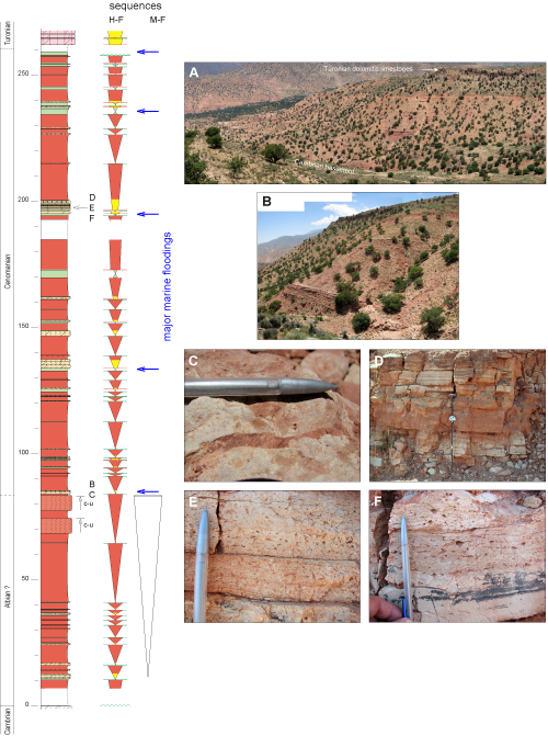
The aim of this study was to understand the timing of fluvial aggradation in depositional sequences correlated from downdip (fully-marine facies) to updip (mostly continental facies) across a passive margin. This basic question of correlation in sequence stratigraphy remains poorly documented and somewhat controversial, especially in passive margins settings versus foreland basins (see Discussion). The Moroccan Atlantic margin provides a great opportunity to trace high-frequency transgressive-regressive sequences over hundreds of kilometres for a number of stratigraphic intervals (Hauterivian, Cenomanian, Coniacian) on a passive margin. The present study deals with uppermost Albian to Cenomanian sequences, in which the relationships between marine and continental facies can be clearly deciphered from a sequence stratigraphic point of view. In the latest Cenomanian to lower Turonian a major marine flooding occurred ( et al., 2005; et al., 2008, 2013; et al., 2010; et al., 2012) all along the northern margin of the Saharan craton, and is responsible for the temporary disappearance of continental deposits in short-term, high-frequency sequences.
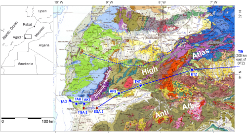
Seven sections, covering the uppermost Albian to Turonian stratigraphic interval, have been logged from the present-day coast to the southern flank of the High-Atlas Mountains, a distance of over than 400 kilometres
(Fig. 1 ![]() ). The most interesting part of the transect, which relates to the sequence stratigraphic objectives of this work, is about 200 km long, between the Taghazoute and Tizi N'Test sections (TAG to TNT in
Fig. 1
). The most interesting part of the transect, which relates to the sequence stratigraphic objectives of this work, is about 200 km long, between the Taghazoute and Tizi N'Test sections (TAG to TNT in
Fig. 1 ![]() ), at the western end of the transect, starting from the Atlantic Ocean. The sections have been logged, taking note of sedimentary features and other observations needed both to understand the depositional facies and to identify surfaces possibly having a stratigraphic value in terms of sequence stratigraphy.
), at the western end of the transect, starting from the Atlantic Ocean. The sections have been logged, taking note of sedimentary features and other observations needed both to understand the depositional facies and to identify surfaces possibly having a stratigraphic value in terms of sequence stratigraphy.
Click on thumbnail to enlarge the image.
Figure 1: Location of the sections and wells studied. Sections: AFS, Afansou; AKT, Askoutti; BTZ, Bou Tazoult; TAH, Tahanoute; TIN, Tinghir; TNT, Tizi N'Test; wells: TGA-2, Tagragra-2, EGA-2, El Gouna-2. Solid blue line, transect studied; dotted blue line, northern transect under study.
As it will be explained in the discussion section of this paper, the hierarchy of the depositional sequences found in the sections studied hardly fit commonly used models. Therefore, in order to avoid terms with interpretative connotations, we will use the terms high-frequency (H-F) and medium-frequency (M-F) sequences instead of parasequences, genetic sequences, and parasequences sets, as well as the fifth- to third order sequence hierarchy of the model developed by Vail and his colleagues (
et al., 1977, 1991). H-F sequences have been grouped into a number of M-F sequences which are the basis for the correlations along the transect, using major flooding episodes. This is especially true in updip, mostly continental sections lacking biostratigraphic data. Well-log data in the Wadi Souss plain and the Tagragra anticline have been used for connecting the western sections (mostly marine facies) to the mixed marine-continental sections situated east of the Argana Triassic corridor
(Fig. 1 ![]() ). Coordinates of the sections are given in
Table I. Marlstones representing the deepest facies in marine sequences have been sampled for foraminiferal biostratigraphy, especially in the western distal sections where the water depth was great enough to allow for the occurrence of
planktic foraminifers. A few ammonites have also been found. The planktic zonal schemes used are those of et al.
(1979), (1985), and and
(1995).
). Coordinates of the sections are given in
Table I. Marlstones representing the deepest facies in marine sequences have been sampled for foraminiferal biostratigraphy, especially in the western distal sections where the water depth was great enough to allow for the occurrence of
planktic foraminifers. A few ammonites have also been found. The planktic zonal schemes used are those of et al.
(1979), (1985), and and
(1995).
Table I: GPS coordinates of the measured sections.
| Sections | Section GPS coordinates | |
| beginning | end | |
| Afansou | 30░41'04"N, 8░47'15"W | 30░41'48"N, 8░47'13"W |
| Askoutti | 30░30'07"N, 9░27'37"W | 30░29'49"N, 9░27'46"W |
| Bou Tazoult | (31░03'52"N, 7░20'19"W) | |
| Taghazoute | 30░34'47"N, 9░45'13"W | 30░33'05"N, 9░44'22"W |
| Tahanoute | 30░30'13"N, 9░35'50"W | 30░29'59"N, 9░36'30"W |
| Tinghir | 31░31'19"N, 5░27'00"W | 31░31'21"N, 5░29'42"W |
| Tizi N'Test | 30░47'25"N, 8░17'48"W | 30░47'50"N, 8░17'20"W |
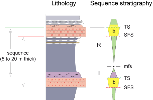
Sequence stratigraphic analysis was done the following way: identify in the successions (a) facies trends tat could be considered as continuous, either shallowing-up or deepening-up, and (b) facies breaks, either corresponding to a sharp deepening (transgressive surface) or to sharp shallowing (sea-level fall surface). The term "sequence boundary" is avoided because it requires an analysis constrained by detailed correlations along a transect.
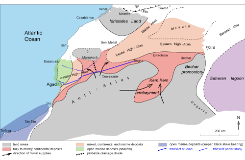
The Cenomanian palaeogeography of Morocco is strongly dependant on the High Atlas rift system ( de et al.,
2011) that developed when the North-African craton broke in Triassic times. Sedimentation in the rift remained marine in Liassic times, and passed to continental deposits in the Bathonian, except in the Western High-Atlas (Gulf of Agadir of & ,
1982).
Figure 2 ![]() is a palaeogeographic map of the study area in Cenomanian times. Cenomanian deposits are overall transgressive, beginning with aggrading coarse-grained fluvial deposits in updip position. The map was developed from our field work in the Western High-Atlas and, to the east, in the so-called Pre-African Trough between the Anti-Atlas and Central to Eastern High-Atlas (Tinghir area). Cenomanian deposits are not preserved in the axial part of the rift, east of Marrakech (Middle Atlas on one hand, and Central to Eastern High-Atlas on the other), due to erosion after the Alpine inversion of the rift. Cenomanian deposits are only known on the shoulders of the two branches of the rift. In these eastern areas, the map is constructed from the works of et al.
(1999) and et al.
(2008, 2010) in the Middle Atlas, of et al.
(2005) and et al.
(2012) on the southern border of the High-Atlas in eastern Morocco, and from et al.
(2014) in the Bechar area (Saharan platform, western Algeria). Stratigraphic data from et al.
(2010) and satellite images are used to delineate the Kem Kem embayment. In the Saharan Atlas of Algeria the data of
(1973) and (1974) are used. Exploration wells and the palaeogeographic synthesis of
(1970) are used to delineate the evaporite lagoon that covered most of the Algerian Sahara in Cenomanian times.
is a palaeogeographic map of the study area in Cenomanian times. Cenomanian deposits are overall transgressive, beginning with aggrading coarse-grained fluvial deposits in updip position. The map was developed from our field work in the Western High-Atlas and, to the east, in the so-called Pre-African Trough between the Anti-Atlas and Central to Eastern High-Atlas (Tinghir area). Cenomanian deposits are not preserved in the axial part of the rift, east of Marrakech (Middle Atlas on one hand, and Central to Eastern High-Atlas on the other), due to erosion after the Alpine inversion of the rift. Cenomanian deposits are only known on the shoulders of the two branches of the rift. In these eastern areas, the map is constructed from the works of et al.
(1999) and et al.
(2008, 2010) in the Middle Atlas, of et al.
(2005) and et al.
(2012) on the southern border of the High-Atlas in eastern Morocco, and from et al.
(2014) in the Bechar area (Saharan platform, western Algeria). Stratigraphic data from et al.
(2010) and satellite images are used to delineate the Kem Kem embayment. In the Saharan Atlas of Algeria the data of
(1973) and (1974) are used. Exploration wells and the palaeogeographic synthesis of
(1970) are used to delineate the evaporite lagoon that covered most of the Algerian Sahara in Cenomanian times.
Click on thumbnail to enlarge the image.
Figure 2: Cenomanian palaeogeographic map.
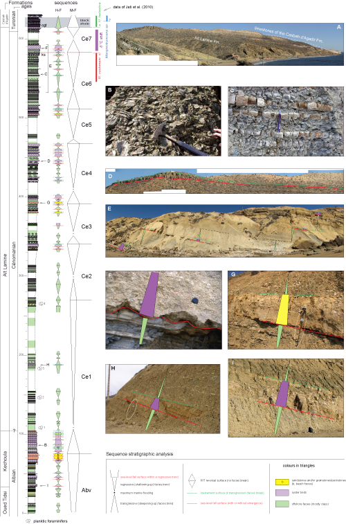
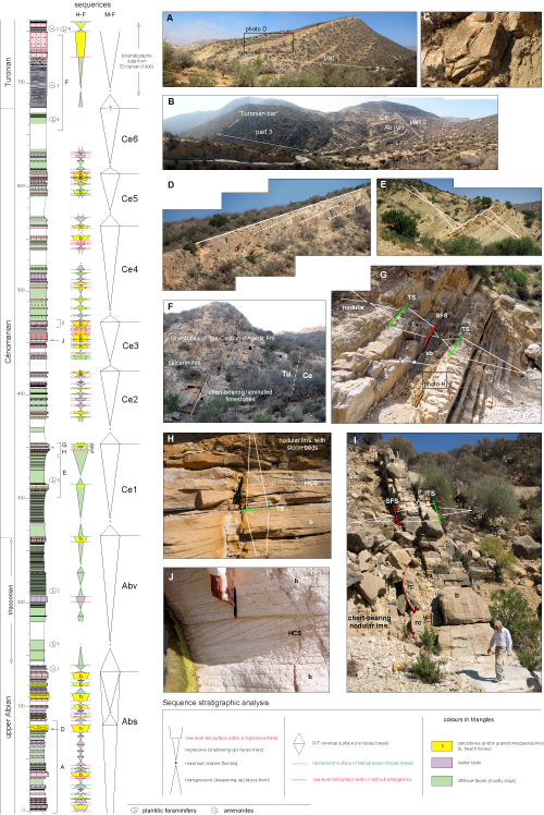
This section (Fig. 3 ![]() ) has been logged on the road side
(Fig. 3.A
) has been logged on the road side
(Fig. 3.A ![]() ), from the uppermost Albian (Vraconnian) Kechoula Formation, and then continued along the sea shore, up to the evenly-bedded, fine-grained, chert-bearing limestones of the Casbah d'Agadir Formation (Turonian). Additional observations have been made in the nearby open country, especially to examine the lateral evolution of some facies,
e.g., oyster beds that are a prominent feature in this distal depositional environment in the Cenomanian. The Cenomanian-Turonian transition has already been studied in detail in this section ( et al.,
2010). The lithostratigraphic scheme is from
(1963).
), from the uppermost Albian (Vraconnian) Kechoula Formation, and then continued along the sea shore, up to the evenly-bedded, fine-grained, chert-bearing limestones of the Casbah d'Agadir Formation (Turonian). Additional observations have been made in the nearby open country, especially to examine the lateral evolution of some facies,
e.g., oyster beds that are a prominent feature in this distal depositional environment in the Cenomanian. The Cenomanian-Turonian transition has already been studied in detail in this section ( et al.,
2010). The lithostratigraphic scheme is from
(1963).
Click on thumbnail to enlarge the image.
Figure 3: Taghazoute section. A, General view; B, oyster shell hash bed; C, evenly-bedded limestone-marl alternation; D, Thickness changes of an oyster bed; E, view of upper Cenomanian sequences along the shore; F, close view of the sharp base of an oyster bed; G to I, examples of distal, sharp-based short-term sequences. Pictures are situated along the log with their respective letters. Abreviations : cgt, polygenic transgressive conglomerate; dls, downlap surface; ks, karst surface; mfs, maximum flooding surface; R, regressive half-cycle; SFS, sea-level fall surface; T, transgressive half-cycle; TS, transgression surface. Pen, hammer, or 1.5 m long Jacob staff (circled) for scale on pictures.
The Kechoula Formation is marked by several metres of calcarenites making a prominent ledge in the topography, which is informally called the "Vraconnian bar". The transition from the underlying Oued Tidsi Marlstone Formation to the Kechoula Formation is gradational, marked by the intercalation of several oyster beds. These beds underlie a few of the H-F sequences which are overall shallower than the marlstone below. The calcarenites making the morphological ledge show an even, laterally continuous stratification. They probably represent a beach facies, forming the top of an overall regressive trend beginning with the underlying marlstone. The calcarenites are overlain by about 25 metres of oyster beds
(Fig. 3.B ![]() ) alternating with grey-green marlstones. This deeper-water facies is interpreted as the transgressive tract of the first medium-frequency Ce1 sequence
(Fig. 3
) alternating with grey-green marlstones. This deeper-water facies is interpreted as the transgressive tract of the first medium-frequency Ce1 sequence
(Fig. 3 ![]() ).
).
The A´t Lamine Formation is rather monotonous. Grey marlstones dominate in its lower half. Metre-scale oyster or calcarenite beds are more common in its upper half. Calcarenites are either bioturbated wackestones or packstones without preserved current structures. Oyster beds are either floatstones in a wackestone matrix, or shell hash beds
(Fig. 3.B ![]() ). Both always have a sharp base on the underlying marlstone
(Fig. 3.F-I
). Both always have a sharp base on the underlying marlstone
(Fig. 3.F-I ![]() ). Marlstones may show thin, reddish, evenly-laminated, fine-grained calcarenite beds interpreted as storm beds. The thickness of some shell hash beds may change dramatically over short distances
(Fig. 3.I
). Marlstones may show thin, reddish, evenly-laminated, fine-grained calcarenite beds interpreted as storm beds. The thickness of some shell hash beds may change dramatically over short distances
(Fig. 3.I ![]() ), and locally pass laterally to metre-scale bioturbated wackestone. In the upper part of the formation (sequence Ce4), a bed-scale limestone-marl alternation
(Fig. 3.C
), and locally pass laterally to metre-scale bioturbated wackestone. In the upper part of the formation (sequence Ce4), a bed-scale limestone-marl alternation
(Fig. 3.C ![]() ) occurs as an additional facies, intercalated between the oyster beds and the overlying grey marlstone. According to et al.
(2010), two unusual surfaces occur near the top of the formation, a karst surface (labelled ks,
Fig. 3
) occurs as an additional facies, intercalated between the oyster beds and the overlying grey marlstone. According to et al.
(2010), two unusual surfaces occur near the top of the formation, a karst surface (labelled ks,
Fig. 3 ![]() ) and a ravinement surface covered by a polygenic microconglomerate (labelled cgt,
Fig. 3
) and a ravinement surface covered by a polygenic microconglomerate (labelled cgt,
Fig. 3 ![]() ). These are interpreted as emergence surfaces which encompass the δ13C positive shift characteristic of the Cenomanian-Turonian transition. Thus, the overlying laminated black shale layer at the base of the limestones of the Casbah d'Agadir Formation is Turonian in age. This is supported by the occurrence of the Turonian
planktic marker Helvetoglobotruncana helvetica in its lower first centimetres
(Fig. 3
). These are interpreted as emergence surfaces which encompass the δ13C positive shift characteristic of the Cenomanian-Turonian transition. Thus, the overlying laminated black shale layer at the base of the limestones of the Casbah d'Agadir Formation is Turonian in age. This is supported by the occurrence of the Turonian
planktic marker Helvetoglobotruncana helvetica in its lower first centimetres
(Fig. 3 ![]() ).
).
The Albian-Cenomanian boundary is not accurately positioned due to the lack of a characteristic fauna. It may not exactly correspond to the boundary between the Kechoula and A´t Lamine Marlstone Formation, although this is commonly accepted after the work of (1963).
Planktic foraminifera are rather scarce in the A´t Lamine Formation, probably due to a shallow depositional depth for the marlstones. Species with stratigraphic value are only encountered in the marl-dominated lower half of the Formation (foraminifera levels 1 to 4,
Fig. 3 ![]() ), and also in its uppermost part (cycle Ce6,
Fig. 3
), and also in its uppermost part (cycle Ce6,
Fig. 3 ![]() ). The foraminiferal assemblage found at level 1 contains Hedbergella delrioensis, H. simplex, H. planispira, Thalmaninella apenninica, Praeglobotruncana aumalensis, and Heterohelix moremani. The co-occurrence of
Thalmaninella apenninica and Praeglobotruncana aumalensis suggests an early Cenomanian age, even with the absence of the marker Thalmaninella globotruncanoides. Thus, it is confirmed that the Albian-Cenomanian boundary could be approximately placed near the base of the A´t Lamine Formation, as already suggested by
(1963). At level 2, the co-occurrence of Thalmaninella apenninica and Globigerinelloides bentonensis also suggests an early Cenomanian age. The first occurrence of Thalmaninella globotruncanoides is at level 3, in an assemblage comprising T. apenninica, Praeglobotruncana aumalensis and Hedbergella delrioensis. At level 4, the first occurrence of Rotalipora montsalvensis with Hedbergella delrioensis, H. simplex, H. planispira and Favusella washitensis suggests a late early Cenomanian age. No characteristic assemblage is found higher up, except in cycle Ce6 where the occurrence of Rotalipora cushmani
(Fig. 3
). The foraminiferal assemblage found at level 1 contains Hedbergella delrioensis, H. simplex, H. planispira, Thalmaninella apenninica, Praeglobotruncana aumalensis, and Heterohelix moremani. The co-occurrence of
Thalmaninella apenninica and Praeglobotruncana aumalensis suggests an early Cenomanian age, even with the absence of the marker Thalmaninella globotruncanoides. Thus, it is confirmed that the Albian-Cenomanian boundary could be approximately placed near the base of the A´t Lamine Formation, as already suggested by
(1963). At level 2, the co-occurrence of Thalmaninella apenninica and Globigerinelloides bentonensis also suggests an early Cenomanian age. The first occurrence of Thalmaninella globotruncanoides is at level 3, in an assemblage comprising T. apenninica, Praeglobotruncana aumalensis and Hedbergella delrioensis. At level 4, the first occurrence of Rotalipora montsalvensis with Hedbergella delrioensis, H. simplex, H. planispira and Favusella washitensis suggests a late early Cenomanian age. No characteristic assemblage is found higher up, except in cycle Ce6 where the occurrence of Rotalipora cushmani
(Fig. 3 ![]() ) indicates a late Cenomanian age, and also probably a deeper-water marlstone. The Middle Cenomanian is not characterized by foraminifera.
) indicates a late Cenomanian age, and also probably a deeper-water marlstone. The Middle Cenomanian is not characterized by foraminifera.
The last occurrence of R. cusmani and the first occurrence of Hedbergella helvetica
leaves a poorly defined interval, about 30 m thick, between well-dated Cenomanian and Turonian deposits. This interval corresponds to the Archeocretacea Foraminifera zone, which thus covers a full depositional sequence (Ce7,
Fig. 3 ![]() ). The position of the Cenomanian-Turonian boundary (CTB) δ13C positive shift
(Fig. 3
). The position of the Cenomanian-Turonian boundary (CTB) δ13C positive shift
(Fig. 3 ![]() ) in this section ( et al.,
2010), allows the stage boundary to be located precisely which, in worldwide reference sections (see for instance et al.,
2013, Fig. 5), is always within the upper part of the isotope anomaly, in this section within the uppermost part of sequence Ce7.
) in this section ( et al.,
2010), allows the stage boundary to be located precisely which, in worldwide reference sections (see for instance et al.,
2013, Fig. 5), is always within the upper part of the isotope anomaly, in this section within the uppermost part of sequence Ce7.
A recurrent pattern is found in the Kechoula and A´t Lamine Formations (Fig.
4 ![]() ). The common occurrence of sharp-based, more-or less calcarenitic oyster beds on offshore claystones
(Fig. 3.F-I
). The common occurrence of sharp-based, more-or less calcarenitic oyster beds on offshore claystones
(Fig. 3.F-I ![]() ) is interpreted as the result of relative sea-level falls which brought the beach prism closer to the Taghazoute location. In this respect, oyster beds or bioturbated calcarenites are interpreted as the lowstand facies of the high-frequency sequences. Their sharp basal boundary is thus interpreted as a sea-level fall surface (SFS). The question as to whether such a surface has to be called a sequence boundary will be discussed further. The lowstand facies in the Taghazoute section usually do not reach the beach facies except in the upper part of the Kechoula Formation where laminated calcarenites are interpreted as such
(Fig.
4
) is interpreted as the result of relative sea-level falls which brought the beach prism closer to the Taghazoute location. In this respect, oyster beds or bioturbated calcarenites are interpreted as the lowstand facies of the high-frequency sequences. Their sharp basal boundary is thus interpreted as a sea-level fall surface (SFS). The question as to whether such a surface has to be called a sequence boundary will be discussed further. The lowstand facies in the Taghazoute section usually do not reach the beach facies except in the upper part of the Kechoula Formation where laminated calcarenites are interpreted as such
(Fig.
4 ![]() ). SFSs are probably never exposure surfaces in this section. The only two interpreted exposure surfaces are in the uppermost part of the Cenomanian succession, below and above the CTB δ13C shift. These two surfaces are probably connected to seaward-shifted beach prisms now in an offshore position, according to et al.
(2010, Fig. 12).
). SFSs are probably never exposure surfaces in this section. The only two interpreted exposure surfaces are in the uppermost part of the Cenomanian succession, below and above the CTB δ13C shift. These two surfaces are probably connected to seaward-shifted beach prisms now in an offshore position, according to et al.
(2010, Fig. 12).
Click on thumbnail to enlarge the image.
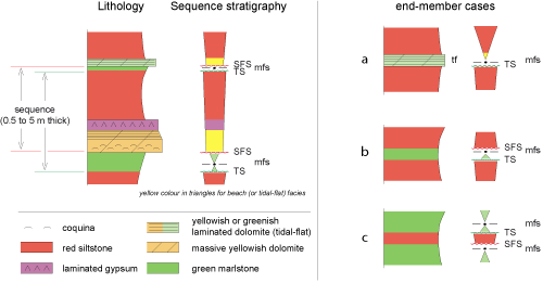
Figure 4: Distal, high-frequency type-sequence. Abreviations as in Fig. 3. b, for beach facies.
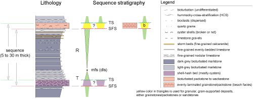
Lowstand facies in the H-F sequence are typically overlain by a finely-bedded limestone-marl alternation
(Fig. 3.C ![]() ), and next by darker grey, usually nodular marlstone with few or no mudstone beds
(Fig. 3.E
), and next by darker grey, usually nodular marlstone with few or no mudstone beds
(Fig. 3.E ![]() ). Thin storm beds may occur in their upper part, below the next SFS. The boundary between the light-grey limestone-marl alternation (the deepest facies in the sequence) and the overlying darker marlstones with storm beds is interpreted as the downlap surface (dls, or maximum flooding surface, mfs) of the prograding coastal prism (highstand deposits) during the regressive half-cycle of the sequence. The most striking observation, in all these H-F sequences, is that the progradation never reached the shoreface to beach deposits in a progressive way. The starting regressive trend is always abruptly cut by the SFS.
). Thin storm beds may occur in their upper part, below the next SFS. The boundary between the light-grey limestone-marl alternation (the deepest facies in the sequence) and the overlying darker marlstones with storm beds is interpreted as the downlap surface (dls, or maximum flooding surface, mfs) of the prograding coastal prism (highstand deposits) during the regressive half-cycle of the sequence. The most striking observation, in all these H-F sequences, is that the progradation never reached the shoreface to beach deposits in a progressive way. The starting regressive trend is always abruptly cut by the SFS.
The finely-bedded limestone-marl alternation represents the transgressive facies of the sequence. It is only present in the upper Cenomanian. In underlying sequences, this facies is not present.
In summary, the observed H-F sequences are basically transgressive-regressive (T-R) sequences, but with the peculiarity that the shallowest facies is bounded at its base by a sea-level fall surface. The sequences bear two stratigraphic surfaces that bound the lowstand facies, a sea-level fall surface (SFS) at the base, and a transgressive surface (TS) at its top. This has been used to construct the H-F sequence stratigraphic column
(Fig. 3 ![]() ). The question as to whether the vertical trend of the lowstand deposits has to be considered as overall transgressive or regressive (prograding)
(Fig. 3
). The question as to whether the vertical trend of the lowstand deposits has to be considered as overall transgressive or regressive (prograding)
(Fig. 3 ![]() ) remains a matter of debate. Also there is the question whether these sequences should called parasequences or full sequences because they are bounded by a surface representing a sea-level fall. This will be discussed below.
) remains a matter of debate. Also there is the question whether these sequences should called parasequences or full sequences because they are bounded by a surface representing a sea-level fall. This will be discussed below.
Seven medium-frequency T-R sequences Ce1 to Ce7, Fig. 3 ![]() ) have been recognized in the Cenomanian succession, over the uppermost Albian Abv (v, for Vraconnian) sequence. These are bounded at their base by a lithological shift to marlstone (deepening), and, at their top, by the shallowest regressive facies. The recognition of Cenomanian sequences is not easy in this distal section. It is also based on regional
correlations (see later section). Sequence Ce7 is probably restricted to the Taghazoute area ( et al.,
2010), as the CTB δ13C shift is not found in eastern sections (Tahanoute to Afansou), as a result of a stratigraphic hiatus.
) have been recognized in the Cenomanian succession, over the uppermost Albian Abv (v, for Vraconnian) sequence. These are bounded at their base by a lithological shift to marlstone (deepening), and, at their top, by the shallowest regressive facies. The recognition of Cenomanian sequences is not easy in this distal section. It is also based on regional
correlations (see later section). Sequence Ce7 is probably restricted to the Taghazoute area ( et al.,
2010), as the CTB δ13C shift is not found in eastern sections (Tahanoute to Afansou), as a result of a stratigraphic hiatus.
The composite section (Fig. 5.A-B ![]() ) has been logged along the banks of Wadi Ida ou Tanane, close to the road from Tamghart to El Ma villages. Cenomanian deposits are thinner than at Taghazoute (370 m vs. 510 m), but they remain fully marine.
) has been logged along the banks of Wadi Ida ou Tanane, close to the road from Tamghart to El Ma villages. Cenomanian deposits are thinner than at Taghazoute (370 m vs. 510 m), but they remain fully marine.
Click on thumbnail to enlarge the image.
Figure 5: Tahanoute section. A, view of the lower part of the section; B, View of the mid and upper parts of the section; C, Wave rippled surfaces within a tide-influenced beach facies; D, dipping surfaces within a beach wedge; E, view of lowermost Cenomanian, marl-dominated sequences (M-F sequence Ce1) (people, circled, for scale); F, view of the Cenomanian-Turonian transition; G, view of the package of H-F sequences at top of a medium-frequency sequence Ce1; H; transition from the evenly-laminated beach facies and the transgressive, HCS-bearing deposits; I; view of a typical H-F sequence showing the beach facies sharply resting on offshore nodular limestones; J, view of a beach facies bearing HCS sandwiched within the even lamination. Abreviations as on Fig. 3; Ab, Albian, Ce, Cenomanian, Tu, Turonian; Vr, Vraconnian; b, beach facies; HCS, hummocky-cross-stratification; oy, oysters; rc, rip current channel; sb, storm beds.
The main change in this section versus that of Taghazoute is the common occurrence of evenly-laminated calcarenites and / or sandstones, associated with hummocky cross stratification (HCS), both of which are indicative of very shallow deposits (shoreface to beach facies,
Fig. 5.H ![]() ). These alternate with deeper deposits (marlstone, nodular mudstone or wackestone, oyster beds) constituting high-frequency T-R sequences. Wave ripples
(Fig. 5.C
). These alternate with deeper deposits (marlstone, nodular mudstone or wackestone, oyster beds) constituting high-frequency T-R sequences. Wave ripples
(Fig. 5.C ![]() ) alternating with evenly laminated calcarenites also suggest that the beach depositional environment was influenced by tides, as these ripples probably represent high-tide features on a beach. Furthermore, the occurrence of HCS sandwiched within the even lamination of the beach facies
(Fig. 5.J
) alternating with evenly laminated calcarenites also suggest that the beach depositional environment was influenced by tides, as these ripples probably represent high-tide features on a beach. Furthermore, the occurrence of HCS sandwiched within the even lamination of the beach facies
(Fig. 5.J ![]() ) could reflect stronger waves during storms occurring at high tide in an intertidal environment. Gently-inclined stratification within some calcarenite beds
(Fig. 5.D
) could reflect stronger waves during storms occurring at high tide in an intertidal environment. Gently-inclined stratification within some calcarenite beds
(Fig. 5.D ![]() ) is interpreted as upper foreshore bedding (beach clinoforms) deposited during the progradation of the coastal prism in the regressive half-cycle of the T-R sequence. These deposits suggest that the Tahanoute section was deposited in an environment overall shallower than that at Taghazoute.
) is interpreted as upper foreshore bedding (beach clinoforms) deposited during the progradation of the coastal prism in the regressive half-cycle of the T-R sequence. These deposits suggest that the Tahanoute section was deposited in an environment overall shallower than that at Taghazoute.
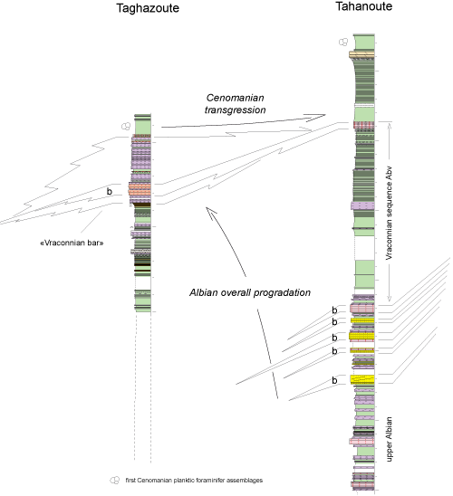
A fact that has to be highlighted is that the prominent morphological ledge at the base of the section
(Fig. 5.A ![]() ) is not coeval with the "Vraconnian bar" of the Taghazoute area (see next paragraph). Despite the poor outcrop conditions
(Fig. 5.F
) is not coeval with the "Vraconnian bar" of the Taghazoute area (see next paragraph). Despite the poor outcrop conditions
(Fig. 5.F ![]() ), the lower Turonian black shales of the Taghazoute section seem to be absent here.
), the lower Turonian black shales of the Taghazoute section seem to be absent here.
Four samples have provided diversified planktic foraminifera assemblages in the lower part of the section (levels 1 to 4,
Fig. 5 ![]() ). At level 1, the association of Hedbergella simplex, H. delrioensis, H. planispira, H. albiana, Favusella washitensis and Ticinella raynaudi suggests an Albian age. At level 2, the association of Hedbergella delrioensis and Favusella washitensis gives a poorly constrained age (Albian to Cenomanian). At level 3, the association of Praeglobotruncana aumalensis, P. delrioensis, Heterohelix reussi, H. moremani, Hedbergella delrioensis, H. planispira, Guembelitria and Whitenella baltica indicates a Cenomanian age. The discovery of an ammonite at the 135 m mark of the section
(Fig. 5
). At level 1, the association of Hedbergella simplex, H. delrioensis, H. planispira, H. albiana, Favusella washitensis and Ticinella raynaudi suggests an Albian age. At level 2, the association of Hedbergella delrioensis and Favusella washitensis gives a poorly constrained age (Albian to Cenomanian). At level 3, the association of Praeglobotruncana aumalensis, P. delrioensis, Heterohelix reussi, H. moremani, Hedbergella delrioensis, H. planispira, Guembelitria and Whitenella baltica indicates a Cenomanian age. The discovery of an ammonite at the 135 m mark of the section
(Fig. 5 ![]() ), a Mortoniceras indicative of the Fallax to Rostratum zones, indicates a late (but not latest) Albian age. These data suggest that most of the recessive marly interval overlying the morphological ledge at the base of the section is not Cenomanian in age, as in the Taghazoute section, but is of latest Albian (Vraconnian) age. The Albian-Cenomanian boundary was therefore placed above a calcarenite bed interpeted as beach facies, by the 260 m mark
(Fig. 5
), a Mortoniceras indicative of the Fallax to Rostratum zones, indicates a late (but not latest) Albian age. These data suggest that most of the recessive marly interval overlying the morphological ledge at the base of the section is not Cenomanian in age, as in the Taghazoute section, but is of latest Albian (Vraconnian) age. The Albian-Cenomanian boundary was therefore placed above a calcarenite bed interpeted as beach facies, by the 260 m mark
(Fig. 5 ![]() ). The "Vraconnian bar" of the Taghazoute section
(Fig. 3
). The "Vraconnian bar" of the Taghazoute section
(Fig. 3 ![]() ) is thus considered to thin updip, as a consequence of an overall Albian prograding pattern
(Fig. 6
) is thus considered to thin updip, as a consequence of an overall Albian prograding pattern
(Fig. 6 ![]() ). Two upper Albian sequences (Abs and Abv) are therefore present in the lower part of the section
(Fig. 5
). Two upper Albian sequences (Abs and Abv) are therefore present in the lower part of the section
(Fig. 5 ![]() ).
).
Click on thumbnail to enlarge the image.
Figure 6: Correlation between upper Albian sequences of the Tahanoute and Taghazoute sections. b, beach facies.
Higher-up in the section, planktic foraminifera are very scarce and without precise biostratigraphic significance. An inferred late Cenomanian assemblage (Heterohelix, Hedbergella, Whitenella baltica) has been found (level 5,
Fig. 5 ![]() ) under the evenly-bedded fine-grained limestones that yielded the early Turonian ammonite Mammites nodosoides (, 1990). In the upper few metres of the section, a late Turonian foraminiferal assemblage (level 5,
Fig. 5
) under the evenly-bedded fine-grained limestones that yielded the early Turonian ammonite Mammites nodosoides (, 1990). In the upper few metres of the section, a late Turonian foraminiferal assemblage (level 5,
Fig. 5 ![]() ) has been found (Dicarinelle imbricata, D. hagni, Marginotruncana schneegansi), together with late Turonian ammonites (Subprionocyclus neptuni, Scaphites
sp., Allocrioceras sp.) of the Neptuni Zone (,
1990). These data allow the positioning of the Cenomanian-Turonian boundary at the base of the evenly-bedded mudstone
(Fig. 5
) has been found (Dicarinelle imbricata, D. hagni, Marginotruncana schneegansi), together with late Turonian ammonites (Subprionocyclus neptuni, Scaphites
sp., Allocrioceras sp.) of the Neptuni Zone (,
1990). These data allow the positioning of the Cenomanian-Turonian boundary at the base of the evenly-bedded mudstone
(Fig. 5 ![]() ), but in the poor outcrop conditions, the updip fate of the two emergence surfaces bounding the Ce7 Cenomanian sequence of the Taghazoute section cannot be determined
(Fig. 3
), but in the poor outcrop conditions, the updip fate of the two emergence surfaces bounding the Ce7 Cenomanian sequence of the Taghazoute section cannot be determined
(Fig. 3 ![]() ).
).
The beach facies is the characteristic feature of this section vs. that of Taghazoute where the shallowest facies are always deeper. Metre-scale beds presenting even, laterally-continuous lamination usually rest sharply on deeper-water deposits through a sea-level fall surface (SFS). These are either marlstone (therefore indicating a strong facies break) or nodular (bioturbated) limestones sometimes bearing oysters and hosting storm beds
(Fig. 5.G & I ![]() ). In some cases, lower foreshore rip-current channels can be observed at the base of the beach facies
(Fig. 5.I
). In some cases, lower foreshore rip-current channels can be observed at the base of the beach facies
(Fig. 5.I ![]() ). The beach facies consists of well-sorted calcarenites or sandstones, or both. The deepest facies in these H-F sequences can be either marlstone, or whitish nodular wackestone, especially in the thinnest sequences. The colour of marlstone is grey to grey-green. In sequences devoid of beach facies, the shallowest deposits are oyster beds or bioturbated, oyster-bearing, poorly-sorted calcarenites. This kind of H-F sequence occurs mostly in transgressive (deepening) half-cycles of the M-F sequences. Oyster beds may not occur as the shallowest deposit in some H-F sequences, like in the Taghazoute section. They also occur at the top of beach calcarenites and/or sandstones, suggesting that this facies should be found at very shallow depths,
i.e., at the toe of the beach wedges, just below the stormweather wave base. When the beach wedge did not reach the Tahanoute area at maximum regressions, the shallowest facies are these oyster beds
(Fig.
4
). The beach facies consists of well-sorted calcarenites or sandstones, or both. The deepest facies in these H-F sequences can be either marlstone, or whitish nodular wackestone, especially in the thinnest sequences. The colour of marlstone is grey to grey-green. In sequences devoid of beach facies, the shallowest deposits are oyster beds or bioturbated, oyster-bearing, poorly-sorted calcarenites. This kind of H-F sequence occurs mostly in transgressive (deepening) half-cycles of the M-F sequences. Oyster beds may not occur as the shallowest deposit in some H-F sequences, like in the Taghazoute section. They also occur at the top of beach calcarenites and/or sandstones, suggesting that this facies should be found at very shallow depths,
i.e., at the toe of the beach wedges, just below the stormweather wave base. When the beach wedge did not reach the Tahanoute area at maximum regressions, the shallowest facies are these oyster beds
(Fig.
4 ![]() ). When the beach wedge did reach the area, oyster beds are often found as transgressive deposits overlying the beach facies.
). When the beach wedge did reach the area, oyster beds are often found as transgressive deposits overlying the beach facies.
These H-F sequences (Fig. 7 ![]() ) may be bounded either between sea-level fall surfaces (SLSs), as they should be according to the principles of sequence stratigraphy, or between transgression surfaces (TSs), as it would be for short-term parasequences. This cannot be resolved through interpreting a single section, but through the overall stratigraphic organization of the sedimentary wedge (see later section, depositional model and discussion).
) may be bounded either between sea-level fall surfaces (SLSs), as they should be according to the principles of sequence stratigraphy, or between transgression surfaces (TSs), as it would be for short-term parasequences. This cannot be resolved through interpreting a single section, but through the overall stratigraphic organization of the sedimentary wedge (see later section, depositional model and discussion).
Click on thumbnail to enlarge the image.
Figure 7: Proximal, full-marine, high-frequency sequence examplified by the Tahanoute section. Abreviations as in Fig. 4.
Based on the stratigraphic repartition of the packages of shallowest facies and on the marlstone-dominanted intervals, a number of M-F sequences can be identified
(Fig. 5 ![]() ). The first upper Albian sequence is strongly regressive, with a number of H-F sequences bearing a beach facies. The uppermost Albian (Vraconnian) M-F sequence is marl-dominated, indicating an overall flooding trend. However, as suggested above
(Fig. 6
). The first upper Albian sequence is strongly regressive, with a number of H-F sequences bearing a beach facies. The uppermost Albian (Vraconnian) M-F sequence is marl-dominated, indicating an overall flooding trend. However, as suggested above
(Fig. 6 ![]() ), a strong facies downwardshift occurred at its top. Six M-F sequences (Ce1 to Ce6,
Fig. 5
), a strong facies downwardshift occurred at its top. Six M-F sequences (Ce1 to Ce6,
Fig. 5 ![]() ) can be recognized in the Cenomanian. Regional correlations also help (see further). Following the study of et al.
(2010), the unconformity-bounded Ce7 sequence is supposed not to occur updip of the Taghazoute area.
) can be recognized in the Cenomanian. Regional correlations also help (see further). Following the study of et al.
(2010), the unconformity-bounded Ce7 sequence is supposed not to occur updip of the Taghazoute area.
The section (Fig. 8 ![]() ) has been logged along a small creek, running north to south across the southern flank of the Ifasfassen anticline, west of the Tinfoul village, and just north of the low-lying Tagragra anticline. Dip is near vertical
(Fig. 8.A
) has been logged along a small creek, running north to south across the southern flank of the Ifasfassen anticline, west of the Tinfoul village, and just north of the low-lying Tagragra anticline. Dip is near vertical
(Fig. 8.A ![]() ).
).
Click on thumbnail to enlarge the image.
Figure 8: Askoutti section. A, View of the lower half of the section; B, View of the Albian sequences; C, View of the upper half of the section; D, view of an overturned bed with an evenly-laminated beach facies; E to H, detailed views of H-F sequences; I, The Cenomanian-Turonian transition; J, late Cenomanian ammonite above a bioturbated calcarenite bed, just under the C-T boundary. Abreviations as in Figs. 3 and 5.
The characteristic feature of this section is the great number of evenly-laminated, well-sorted calcarenite or sandy calcarenite beds (beach facies), alternating with oyster beds and marlstone interbeds. These calcarenite beds are more or less dolomitized in the lowermost part of the section. As a whole, the thickness of marlstone beds is much less than in the previous sections. The succession is thus very complex, due to an overall thinning of H-F sequences (especially in Cenomanian deposits) vs. the more distal sections of Tahanoute and Taghazoute. Beds with a beach facies
(b in Fig. 8 ![]() ) tend to be thicker (up to ten metres) in the lower (Albian) part of the section.
) tend to be thicker (up to ten metres) in the lower (Albian) part of the section.
As in the Tahanoute section, a marked lithological change occurs in the upper part of the section, where white, finely-bedded micritic limestone rest sharply on the last Cenomanian calcarenite bed. These limestones are evenly-laminated (anoxic?) in their lower part. Higher up, beds become thicker and chert-bearing, with wavy boundaries. The transition to the Turonian cliff-forming calcarenites is sharp.
The succession is poorly-dated due to the lack or scarcity of planktic foraminifers (except in Turonian white limestones). Ammonites are also very scarce. According to and (1982), the lower part of the section is uppermost Albian in age. Given that their detailed log can be confidently correlated with ours, this view is accepted here. Planktic foraminifers are absent in upper Albian sequences. Surface dwellering heterohelicids without biostratigraphic significance are found in sequences Ce1, Ce4 and Ce5. In sequence Ce2 and Ce3, assemblages of benthic foraminifera (Quinqueloculina, Cribratina texana, Cuneolina, Daxia and Gavelinopsis) suggest an early Cenomanian age. The scarcity of planktic foraminifera suggests that green marlstones, the deepest facies in the succession, were deposited at very shallow depth.
The occurrence of Hedbergella flandrini amid a fauna dominated by hedbergellids, heterohelicids and whiteinellids, about four metres above the base of the white limestones in the upper part of the section
(Fig. 8.C ![]() ), indicates a late early to middle Turonian age
(Marginotruncana schneegansi Zone), after et al.
(2010). The early Turonian Helvetoglobotruncana helvetica Zone has not been identified. These white limestones rest sharply
(Fig. 8.I
), indicates a late early to middle Turonian age
(Marginotruncana schneegansi Zone), after et al.
(2010). The early Turonian Helvetoglobotruncana helvetica Zone has not been identified. These white limestones rest sharply
(Fig. 8.I ![]() ) on calcarenite beds alternating with marlstone of late, but not necessarily latest Cenomanian age
( in et al.,
2010) due to the presence of a poorly preserved ammonite (Neolobites gr. vibreyanus or Metengonoceras gr. dumbli)
(Fig. 8.J
) on calcarenite beds alternating with marlstone of late, but not necessarily latest Cenomanian age
( in et al.,
2010) due to the presence of a poorly preserved ammonite (Neolobites gr. vibreyanus or Metengonoceras gr. dumbli)
(Fig. 8.J ![]() ). According to et al.
(2010), the absence of the CTB δ13C shift suggests a stratigraphic hiatus probably covering at least the Ce7 sequence of the Taghazoute section, and perhaps part of the lowermost Turonian, according to
planktic foraminifera.
). According to et al.
(2010), the absence of the CTB δ13C shift suggests a stratigraphic hiatus probably covering at least the Ce7 sequence of the Taghazoute section, and perhaps part of the lowermost Turonian, according to
planktic foraminifera.
The H-F sequences are similar to those found in the Tahanoute section (Fig. 7 ![]() ). Most show a strong facies break (sea-level fall surface, SFS) at the base of beds bearing a beach facies
(Fig. 8.D-H
). Most show a strong facies break (sea-level fall surface, SFS) at the base of beds bearing a beach facies
(Fig. 8.D-H ![]() ). Very few sequences appear as more transitional (more regularly prograding). The facies break is more or less strong, as the evenly-laminated calcarenites may rest either on oyster beds or directly on marlstone. This is the main characteristic of this section, such as in the Tahanoute section: the planar-laminated, laterally-continous calcarenite beds interpreted as a beach facies occur repeatedly to form relatively thin (averaging ten metres) sequences, except in the upper Albian where beds with a beach facies are thicker. There are no storm beds in the deepest facies, unlike in the Taghazoute or Tahanoute sections, suggesting that the depositional environment was a flat, low-energy ramp, preventing the occurrence of rip currents during the highstands in relative sea level. In a number of sequences, the beach facies is often interrupted by oyster beds or bioturbated calcarenites, indicating high-frequency moderate floodings. This again is interpreted as indicative of a flat, low-energy ramp on which the slightest change in relative sea level would have displaced the shoreline over rather long distances, but without inducing a strong deepening seawards.
). Very few sequences appear as more transitional (more regularly prograding). The facies break is more or less strong, as the evenly-laminated calcarenites may rest either on oyster beds or directly on marlstone. This is the main characteristic of this section, such as in the Tahanoute section: the planar-laminated, laterally-continous calcarenite beds interpreted as a beach facies occur repeatedly to form relatively thin (averaging ten metres) sequences, except in the upper Albian where beds with a beach facies are thicker. There are no storm beds in the deepest facies, unlike in the Taghazoute or Tahanoute sections, suggesting that the depositional environment was a flat, low-energy ramp, preventing the occurrence of rip currents during the highstands in relative sea level. In a number of sequences, the beach facies is often interrupted by oyster beds or bioturbated calcarenites, indicating high-frequency moderate floodings. This again is interpreted as indicative of a flat, low-energy ramp on which the slightest change in relative sea level would have displaced the shoreline over rather long distances, but without inducing a strong deepening seawards.
The number of beach beds decreases in the Cenomanian where most of the sea-level lowstand deposits are represented by oyster beds. They are used to define M-F sequences.
Two M-F sequences (Abs and Abv, Fig. 8 ![]() ) can be recognized in upper Albian deposits. These two sequences can be correlated with those of the Tahanoute section, but the second sequence is overall shallower and thinner, owing to the number of H-F sequences bearing a beach facies. Six M-F sequences have been tentatively recognized in Cenomanian deposits, by comparison with the previous sections, but they are not as clearly defined as in the downdip sections. The occurrence of thin beds with a beach facies at marks 290 m, 340 m, 415 m and 470m are the only evidence to bound the sequences Ce2 to Ce5. Marlstone is better represented in sequences Ce5 and Ce6, indicating a low in the morphology
(Fig. 8.C
) can be recognized in upper Albian deposits. These two sequences can be correlated with those of the Tahanoute section, but the second sequence is overall shallower and thinner, owing to the number of H-F sequences bearing a beach facies. Six M-F sequences have been tentatively recognized in Cenomanian deposits, by comparison with the previous sections, but they are not as clearly defined as in the downdip sections. The occurrence of thin beds with a beach facies at marks 290 m, 340 m, 415 m and 470m are the only evidence to bound the sequences Ce2 to Ce5. Marlstone is better represented in sequences Ce5 and Ce6, indicating a low in the morphology
(Fig. 8.C ![]() ). For this reason, they could represent the upper Cenomanian, as a coeval deepening has been found in the same sequences at Taghazoute, on the basis of the reappearance of carinate
planktic foraminifers.
). For this reason, they could represent the upper Cenomanian, as a coeval deepening has been found in the same sequences at Taghazoute, on the basis of the reappearance of carinate
planktic foraminifers.
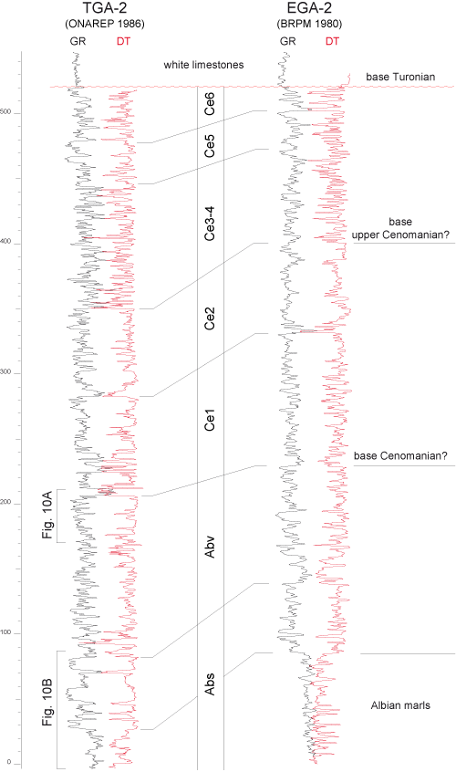
The Tagragra well (TGA-2) was drilled on the top of a low-lying breached anticline in Upper Cretaceous deposits bordering the Souss Plain to the north
(Fig. 1 ![]() ). This well is located a few kilometres south of the Askoutti section. It will help correlate with the (EGA-2) well, drilled farther east in the Souss Plain, in a more updip paleogeographic position.
). This well is located a few kilometres south of the Askoutti section. It will help correlate with the (EGA-2) well, drilled farther east in the Souss Plain, in a more updip paleogeographic position.
The well logs of the two wells are very similar (Fig. 9 ![]() ). Both show a large number of H-F sequences looking like the sharp-based beach sequences of the Askoutti section
(Fig. 10
). Both show a large number of H-F sequences looking like the sharp-based beach sequences of the Askoutti section
(Fig. 10 ![]() ). The two upper Albian M-F sequences, as well as the Ce1 and Ce2 Cenomanian sequences are easily recognizable in both wells, because they are bounded at their top by strong shifts on the GR log (marine flooding surfaces). Their total thickness is similar to that of their counterparts in the Askoutti section. The Ce3 to Ce6 sequences are poorly-defined (see later section on regional correlations).
). The two upper Albian M-F sequences, as well as the Ce1 and Ce2 Cenomanian sequences are easily recognizable in both wells, because they are bounded at their top by strong shifts on the GR log (marine flooding surfaces). Their total thickness is similar to that of their counterparts in the Askoutti section. The Ce3 to Ce6 sequences are poorly-defined (see later section on regional correlations).
Click on thumbnail to enlarge the image.
Figure 9: Correlated well logs of the TGA-2 and EGA-2 wells. GR, gamma-ray; DT, sonic. Abs, upper Albian M-F sequence, Abv, uppermost Albian (Vraconnian) sequence; Ce1 to Ce6, Cenomanian M-F sequences.
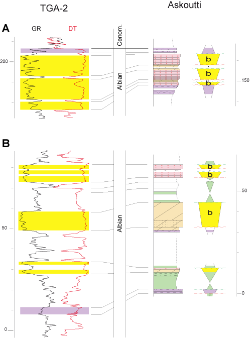
Click on thumbnail to enlarge the image.
Figure 10: Comparison of outcropping high-frequency sequences (Askoutti section) and well log responses (TGA-2) in Albian sequences.
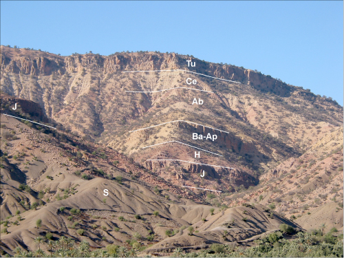
This section is located on the northern flank of an east-west anticline, cut by a wadi running north to south (Wadi Ouaar), south of the Atlasic thrust. A companion section can be logged on the southern flank of the anticline along the wadi, just NE of the Tamaloukt village. The Afansou section is the most complete. It was logged along the snaking mountain trail connecting Tamaloukt to Afansou.
Unlike the western sections that rest on a thick Jurassic to Lower Cretaceous sedimentary succession, the pre-Barremian deposits of the Afansou (and Tamaloukt) sections are strongly reduced in thickness
(Fig. 11 ![]() ). Silurian shales are overlain by about forty metres of undated variegated deposits overlain by Jurassic marine carbonates, then by ten to twenty metres of red fluvial deposits attributed to the upper Hauterivan Talmest Formation, based on current unpublished work on the Essaouira transect (dotted blue line in
Fig. 1
). Silurian shales are overlain by about forty metres of undated variegated deposits overlain by Jurassic marine carbonates, then by ten to twenty metres of red fluvial deposits attributed to the upper Hauterivan Talmest Formation, based on current unpublished work on the Essaouira transect (dotted blue line in
Fig. 1 ![]() ). Barremian (?) to Albian deposits are full marine, represented by an alternation of green marlstone, yellowish dolomite and sandstone with minor coarse-grained calcarenite. Intercalations of red clay occur higher up, within marine deposits, up to the cliff-forming Turonian dolomite. These red beds are one of the main characteristics of the upper Albian to Cenomanian deposits of the section.
). Barremian (?) to Albian deposits are full marine, represented by an alternation of green marlstone, yellowish dolomite and sandstone with minor coarse-grained calcarenite. Intercalations of red clay occur higher up, within marine deposits, up to the cliff-forming Turonian dolomite. These red beds are one of the main characteristics of the upper Albian to Cenomanian deposits of the section.
Click on thumbnail to enlarge the image.
Figure 11: General view of the sedimentary succession in Djebel Tichicht, close to the Afansou section. S, Silurian shales; J, Jurassic carbonates; H, upper Hauterian continental deposits; Ba-Ap, Barremian to Aptian dolomites; Ab, Albian mixed, marine-continental deposits, Ce, Cenomanian; Tu, Turonian.
The section (Fig. 12 ![]() ) begins with the first red beds intercalated in Albian marine deposits. The succession is very complex, comprising an alternation of green marlstone or claystone, yellowish to greenish dolomite, local sandstone, laminated gypsum and red siltstones to claystones. Secondary gypsum may occur as a net of veins in red siltstone. Dolomite beds are either massive, structureless or finely laminated. Some of them contain aligned, laterally-continuous shell ghosts, suggesting a beach deposit
(Fig. 12.D
) begins with the first red beds intercalated in Albian marine deposits. The succession is very complex, comprising an alternation of green marlstone or claystone, yellowish to greenish dolomite, local sandstone, laminated gypsum and red siltstones to claystones. Secondary gypsum may occur as a net of veins in red siltstone. Dolomite beds are either massive, structureless or finely laminated. Some of them contain aligned, laterally-continuous shell ghosts, suggesting a beach deposit
(Fig. 12.D ![]() ). A coarsening-upward sandstone bed, by the mark 145 m, showing a gently-inclined stratification
(Fig. 12.A
). A coarsening-upward sandstone bed, by the mark 145 m, showing a gently-inclined stratification
(Fig. 12.A ![]() ), is interpreted as a beach facies with progradation clinoforms. Usually, the shallowest marine facies intercalated between the continental red siltstone and the green marlstone are laterally-continuous laminated dolomite, interpreted as tidal-flat facies. These are mostly rather greenish than yellowish in colour. Laminated gypsum beds are commonly an alternation of gypsum layers and clay seams. At the inferred Cenomanian-Turonian boundary, ca. 315 m, a breccia bed consisting of poorly-rounded limestone clasts has been observed
(Fig. 12.B
), is interpreted as a beach facies with progradation clinoforms. Usually, the shallowest marine facies intercalated between the continental red siltstone and the green marlstone are laterally-continuous laminated dolomite, interpreted as tidal-flat facies. These are mostly rather greenish than yellowish in colour. Laminated gypsum beds are commonly an alternation of gypsum layers and clay seams. At the inferred Cenomanian-Turonian boundary, ca. 315 m, a breccia bed consisting of poorly-rounded limestone clasts has been observed
(Fig. 12.B ![]() ).
).
Click on thumbnail to enlarge the image.
Figure 12: Afansou section. A., clinoforms within a beach wedge in an Albian high-frequency sequence; B, View of the breccia bed at the C-T boundary; C to I, examples of high-frequency sequences (explanations in the text); D, detailed view of the beach facies (b) at the top of the sequence in picture C. Pen, hammer, or 1,5 m long Jacob staff (circled) for scale on pictures. Abreviations as in Figs. 3 and 5. Yellow colour in sequence stratigraphic interpretation means beach or tidal flat facies.
The section is poorly dated, as the most open-marine deposits are barren of planktic foraminifera. Green marlstone has only yielded benthic foraminifera, ostracods, green algae, and debris of other shallow-water organisms. No ammonite were found. Age assignments are thus only based on the correlation of M-F sequences (see below).
The uppermost 30 metres of Cenomanian deposits, under the breccia bed of the C-T boundary, become fully marine, without any intercalation of red siltstone. This interval could correspond to the upper Cenomanian which is overall transgressive in Taghazoute and Tahanoute distal sections.
According to et al. (2010), the C-T boundary δ13C shift is not present, which suggests a stratigraphic hiatus underlined by the breccia bed at the mark 315 m
(Fig. 12.B ![]() ). The breccia bed is thus interpreted as formed by the reworking of the gravels of a palaeosoil during the low-energy Turonian transgression.
). The breccia bed is thus interpreted as formed by the reworking of the gravels of a palaeosoil during the low-energy Turonian transgression.
The section comprises a very large number of high-frequency, metre-scale or even decimetre-scale T-R sequences. These sequences are reminiscent of those found in more distal sections, except for their thickness which is in general much less. In addition, two more facies are present, gypsum and red siltstone beds. An example of the fully marine sequences can be seen in
Figure 12.C ![]() . Highstand green marlstone is directly overlain by a more or less dolomitized, evenly-stratified shelly calcarenite overlain in turn by a fine-grained laminated dolomite interpreted as a low-energy beach facies. This is overlain by tidal-flat facies
(Fig. 12.D
. Highstand green marlstone is directly overlain by a more or less dolomitized, evenly-stratified shelly calcarenite overlain in turn by a fine-grained laminated dolomite interpreted as a low-energy beach facies. This is overlain by tidal-flat facies
(Fig. 12.D ![]() ). The contact between the beach deposits and the underlying green marlstone is always sharp, suggesting the occurrence of a sea-level fall surface within the regressive half-cycle of the T-R sequence
(Fig. 12.C
). The contact between the beach deposits and the underlying green marlstone is always sharp, suggesting the occurrence of a sea-level fall surface within the regressive half-cycle of the T-R sequence
(Fig. 12.C ![]() ). Highstand green marlstone of the next sequence is also sharply resting on the tidal-flat deposits, through a transgressive surface.
). Highstand green marlstone of the next sequence is also sharply resting on the tidal-flat deposits, through a transgressive surface.
When present, red siltstone occurs between the beach facies and the overlying green marlstone. Gypsum beds also have a common position, between the beach and/or tidal facies, and the red siltstones. It should also be emphasized that the marine-continental transition in the sequence never appears as erosive. The two facies breaks encountered are at the base of the beach facies and at the base of green marlstone (the SFS and TS surfaces, respectively). The marine-continental transition is thus considered as the upper part of the regressive half-cycle of the T-R sequence. The gypsum beds, when present, are interpreted as an evaporite facies deposited in back beach lagoons before the aggradation of the red siltstone.
The beach facies may be very thin (Fig. 12.E ![]() ) between green marlstone and the uppermost facies (gypsum and red siltstone) of the sequences. The marine facies of some sequences can be reduced to a green tidal-flat facies directly overlain by red siltstone
(Fig. 12.F-H
) between green marlstone and the uppermost facies (gypsum and red siltstone) of the sequences. The marine facies of some sequences can be reduced to a green tidal-flat facies directly overlain by red siltstone
(Fig. 12.F-H ![]() ). Colour changes may not be sharp, due to two mechanisms, (a) the bleaching of the red siltstone that become greenish under the transgressive surface, and (b) the continental reddening of the greenish tidal-flat deposits under the red siltstone
(Fig. 12.H
). Colour changes may not be sharp, due to two mechanisms, (a) the bleaching of the red siltstone that become greenish under the transgressive surface, and (b) the continental reddening of the greenish tidal-flat deposits under the red siltstone
(Fig. 12.H ![]() ). The abrupt intercalation of red siltstone within highstand green marlstone occurs locally
(Fig. 12.I
). The abrupt intercalation of red siltstone within highstand green marlstone occurs locally
(Fig. 12.I ![]() ). This is interpreted as an end-member sequence in the depositional model proposed (see later section).
). This is interpreted as an end-member sequence in the depositional model proposed (see later section).
All the variations of the H-F sequence found in this section are shown in Figure
13 ![]() .
.
Click on thumbnail to enlarge the image.
Figure 13: High-frequency type-sequence of the Afansou section, with end-members a to c. Abreviations as in Fig. 4.
Three medium-frequency T-R sequences can be confidently recognized in the lower half of the section
(Fig. 12 ![]() ). Both comprise mostly marine deposits at the base and mostly red fluvial siltstone in their upper part. Higher up, it is difficult to discern H-F sequences in this very complex succession.
). Both comprise mostly marine deposits at the base and mostly red fluvial siltstone in their upper part. Higher up, it is difficult to discern H-F sequences in this very complex succession.
The section was logged in ravines (Fig. 14.A ![]() ), below the road climbing from the Souss Plain to the Tizi N'Test Pass in the High-Atlas. The succession is dominated by red siltstone and claystone
(Fig. 14
), below the road climbing from the Souss Plain to the Tizi N'Test Pass in the High-Atlas. The succession is dominated by red siltstone and claystone
(Fig. 14 ![]() ) resting directly on the Cambrian basement. Sandstones are scarce
(Fig. 14.B
) resting directly on the Cambrian basement. Sandstones are scarce
(Fig. 14.B ![]() ) and made of laterally-continuous massive or graded beds
(Fig. 14.C
) and made of laterally-continuous massive or graded beds
(Fig. 14.C ![]() ), alternating with siltstone, and organized into coarsening-upward units, interpreted as lobe deposits in a fluvial system. Marine deposits are represented by thin dolomite beds bearing even-lamination and birdeyes
(Fig. 14.D-F
), alternating with siltstone, and organized into coarsening-upward units, interpreted as lobe deposits in a fluvial system. Marine deposits are represented by thin dolomite beds bearing even-lamination and birdeyes
(Fig. 14.D-F ![]() ) interpreted as tidal-flat deposits. Green marlstone representing stronger marine floodings occurs in the upper half of the section. As in the other sections, marine carbonate (dolomitized) caps the succession. These are attributed to the Turonian and/or uppermost Cenomanian-Turonian. No biostratigraphic data are available in the underlying, mostly fluvial deposits.
) interpreted as tidal-flat deposits. Green marlstone representing stronger marine floodings occurs in the upper half of the section. As in the other sections, marine carbonate (dolomitized) caps the succession. These are attributed to the Turonian and/or uppermost Cenomanian-Turonian. No biostratigraphic data are available in the underlying, mostly fluvial deposits.
Click on thumbnail to enlarge the image.
Figure 14: Tizi N'Test section. A, General view; B, detailed view of the upper prograding part of a fluvial-dominated M-F sequence (lowest sequence on the log); C, sandstone beds alternating with red siltstones (flood layers) in the upper part of the sequence shown in Fig. B; D to F, views of laminated carbonate deposits interpreted as tidal-flat facies, and showing (Fig. E and F) aligned little vugs (birdeyes?).
Most of the sequences belong to the end-member cases a and b, already identified in the Afansou section
(Fig.
13 ![]() ). These sequences are marked by the strong development of regressive continental deposits overlying the thin, transgressive tidal-flat deposits.
). These sequences are marked by the strong development of regressive continental deposits overlying the thin, transgressive tidal-flat deposits.
M-F sequences are difficult to recognize in such a succession. Major floodings are represented by the thickest marine deposits (blue arrows in
Fig. 14 ![]() ).
).
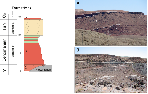
The section is located close to a secondary road west of the Bou Tazoult manganese mine. The sedimentary succession is here strongly reduced in thickness
(Fig. 15 ![]() ). Resting on Triassic basalts or on Jurassic continental deposits, or directly on the Precambrian basement depending on places in the area, merely twenty metres of red claystone and thin sandstone beds passing upward to a few metres of green marine claystone interstratified with red siltstone layers have been logged
(Fig. 15.A
). Resting on Triassic basalts or on Jurassic continental deposits, or directly on the Precambrian basement depending on places in the area, merely twenty metres of red claystone and thin sandstone beds passing upward to a few metres of green marine claystone interstratified with red siltstone layers have been logged
(Fig. 15.A ![]() ). The claystone is overlain by a couple of thick dolomite beds bearing scattered macrofossils including oysters and ghosts of rudists. The dolomite beds are overlain by mixed marine and red continental deposits attributed to the "Senonian" (? Coniacian). Laterally, violet-coloured siltstone and sandstone, probably representing a different sequence (see later section), and onlapping the basement, are intercalated between the Aoufouss Formation and the Precambrian basement.
). The claystone is overlain by a couple of thick dolomite beds bearing scattered macrofossils including oysters and ghosts of rudists. The dolomite beds are overlain by mixed marine and red continental deposits attributed to the "Senonian" (? Coniacian). Laterally, violet-coloured siltstone and sandstone, probably representing a different sequence (see later section), and onlapping the basement, are intercalated between the Aoufouss Formation and the Precambrian basement.
Click on thumbnail to enlarge the image.
Figure 15: Reduced Bou Tazoult section. A and B, general views of the section. The logged section corresponds to picture B. In A, a (poorly-dated) violet continental succession (2) is intercalated between the Paleozoic basement and the Cenomanian Aoufouss Formation. Lithologic units : 1, basement; 2, coarsening-up violet fluvial sequence; 3, Cenomanian Aoufouss Formation (fluvial at base, marine at top); 4, fossiliferous dolomite beds of the uppermost Cenomanian (?) - Turonian marine flooding; 5, Senonian (Coniacian?) mixed, continental-marine deposits.
The dolomite beds of the Bou Tazoult section are not accurately dated. They could represent the deposits of the latest Cenomanian transgression documented farther east in the PreAfrican Trough ( et al., 2012) as well as Turonian carbonates. This latest Cenomanian transgression has been documented over the whole northeastern Saharan craton ( et al., 2008, 2013), just prior to the C-T boundary δ13C shift.
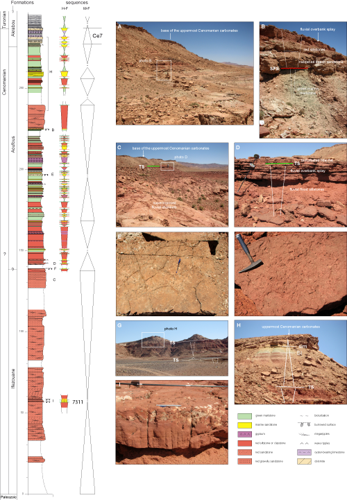
The section (Fig. 16 ![]() ) was logged a few kilometres NE of the town, along the cuesta formed by uppermost Cenomanian to lower Turonian carbonates. Red continental deposits attributed to the Cenomanian "transgression"
(i.e., in fact, a return to a positive accommodation) rest directly on Ordovician deposits (Moroccan geological map).
) was logged a few kilometres NE of the town, along the cuesta formed by uppermost Cenomanian to lower Turonian carbonates. Red continental deposits attributed to the Cenomanian "transgression"
(i.e., in fact, a return to a positive accommodation) rest directly on Ordovician deposits (Moroccan geological map).
Click on thumbnail to enlarge the image.
Figure 16: Tinghir section. A, view of the upper part of the section showing the alternation of green (marine) and red (continental) deposits; B, detailed view; C, upper part of a medium-frequency sequence showing superimposed fluvial channels filled with coarse-grained sandstones (C), and finer-grained, evenly-stratified sandstone of splay deposits (D); E, F and I, different views of evenly-stratified medium-grained sansdtones showing marine burrows, and interpreted as tidal flat deposits, post-depositionally reddened by the fluvial deposits below and above; G and H, uppermost part of the section showing the gradual transition from the fluvial and the full-marine deposits of the C-T transition.
The section begins with about 140 m of mostly red sandy deposits representing amalgamated fluvial channels
(Fig. 16.C ![]() ), and attributed to the Ifezouane Formation, or to the "Infra-Cenomanian" (Moroccan Geological Map). Burrowed sandstone by the mark 60 m suggests an intercalation of coastal-marine deposits despite their red colour. The Aoufous Formation
(Fig. 16
), and attributed to the Ifezouane Formation, or to the "Infra-Cenomanian" (Moroccan Geological Map). Burrowed sandstone by the mark 60 m suggests an intercalation of coastal-marine deposits despite their red colour. The Aoufous Formation
(Fig. 16 ![]() ) comprises a complex alternation
(Fig. 16.A & H
) comprises a complex alternation
(Fig. 16.A & H ![]() ) of red deposits (mostly claystone and siltstone), green marlstone and yellowish to red bioturbated sandstone. Green marlstone is a fully marine deposit, as in previous sections. Post-depositional continental reddening of bioturbated marine sandstone
(Fig. 16.E-F & I
) of red deposits (mostly claystone and siltstone), green marlstone and yellowish to red bioturbated sandstone. Green marlstone is a fully marine deposit, as in previous sections. Post-depositional continental reddening of bioturbated marine sandstone
(Fig. 16.E-F & I ![]() ) complicates the analysis of deposits. Intercalations of continental sandstone in the Aoufous Formation are either amalgamated channel fills bearing megaripples, or laterally-continuous sandstone beds representing overbank splays
(Fig. 16.D
) complicates the analysis of deposits. Intercalations of continental sandstone in the Aoufous Formation are either amalgamated channel fills bearing megaripples, or laterally-continuous sandstone beds representing overbank splays
(Fig. 16.D ![]() ). Some gypsum beds are present. The Akrabou Formation is fully marine, comprising shallow-water carbonates (mostly dolomitized) at the base, and finely-bedded carbonate mudstone at the top. This formation is similar to the CTB sections described elsewhere in the Central High Alas ( et al.,
2005) and the PreAfrican Trough ( et al.,
2012). The stratigraphic position of the CTB δ13C shift, as well as biostratigraphic data ( et al.,
2012) suggest that the basal shallow-water carbonates of the formation are latest Cenomanian, and the overlying, evenly-bedded mudstone early Turonian in age. So, contrarily to what has been found in the western Askoutti and Afansou sections, there is no stratigraphic hiatus indicative of prolonged emergence in the C-T boundary intervall at Tinghir.
). Some gypsum beds are present. The Akrabou Formation is fully marine, comprising shallow-water carbonates (mostly dolomitized) at the base, and finely-bedded carbonate mudstone at the top. This formation is similar to the CTB sections described elsewhere in the Central High Alas ( et al.,
2005) and the PreAfrican Trough ( et al.,
2012). The stratigraphic position of the CTB δ13C shift, as well as biostratigraphic data ( et al.,
2012) suggest that the basal shallow-water carbonates of the formation are latest Cenomanian, and the overlying, evenly-bedded mudstone early Turonian in age. So, contrarily to what has been found in the western Askoutti and Afansou sections, there is no stratigraphic hiatus indicative of prolonged emergence in the C-T boundary intervall at Tinghir.
Finally, depositional facies show that, from the base to the top of the section, there is a progressive evolution from a proximal fluvial (Ifezouane Formation) to a fully marine (Akrabou Formation) depositional environment.
High-frequency sequences are impossible to delineate in the basal Ifezouane Formation. The alternation of marine and continental deposits in the Aoufous Formation permits the identification of them
(Fig. 16 ![]() ) in the same way than as in the Afansou section
(Figs. 12
) in the same way than as in the Afansou section
(Figs. 12 ![]() - 13
- 13 ![]() ).
).
A number of M-F sequences can be tentatively recognized, especially in the complex Aoufous Formation, on the basis of the relative importance of facies between continental and marine deposits within the complex alternation. Without precise biostratigraphic data, these M-F sequences cannot be confidently correlated with those of the Atlantic segment of the transect, except for the base of the Akrabou Formation that should correspond to the Ce7 sequence of the Taghazoute section
(Fig. 3 ![]() ), since it hosts the CTB δ13C shift. However here, on the eastern side of the transect, there is no indication of any subaerial exposure around the C-T boundary, rather an acceleration of the flooding.
), since it hosts the CTB δ13C shift. However here, on the eastern side of the transect, there is no indication of any subaerial exposure around the C-T boundary, rather an acceleration of the flooding.
Both published data and high-resolution satellite colour pictures show that Tinghir-like sections can be traced all along the northern, eastern and southeastern border of the Anti-Atlas Massif ( et al.,
2001), which probably constituted the main source for the Cenomanian terrigenous material. South of the Anti-Atlas Massif, in the Kem Kem area
(Fig. 2 ![]() ), the Gara Sbaa is a well-known fossiliferous site ( et al.,
2010; et al.,
2011; & ,
2013), both in the continental Kem Kem Beds and in the overlying marine carbonates. The section begins with coarse-grained fluvial deposits (amalgamated channels) attibuted to the "Infra-Cenomanian" (Moroccan geological map) or the Cenomanian Ifezouane Formation ( et al.,
2010). Continental deposits then become finer-grained (mostly red claystone hosting marine green marlstone beds), and attributed to the Cenomanian Aoufous Formation. These predominantly continental deposits comprising the Kem Kem beds are overlain by the fully marine carbonate Akrabou Formation representing the uppermost Cenomanian to Turonian stepped marine flooding. Uppermost Cenomanian shallow-water carbonates are overlain by finely-bedded or laminated carbonate mudstone bearing fish remains and representing the early Turonian maximum flooding. This section is, except for its thickness, very similar to the Tinghir section. Satellite pictures show that the Kem Kem Beds thin to the south, delineating what is called here a palaeogeographic Kem Kem embayment
(Fig. 2
), the Gara Sbaa is a well-known fossiliferous site ( et al.,
2010; et al.,
2011; & ,
2013), both in the continental Kem Kem Beds and in the overlying marine carbonates. The section begins with coarse-grained fluvial deposits (amalgamated channels) attibuted to the "Infra-Cenomanian" (Moroccan geological map) or the Cenomanian Ifezouane Formation ( et al.,
2010). Continental deposits then become finer-grained (mostly red claystone hosting marine green marlstone beds), and attributed to the Cenomanian Aoufous Formation. These predominantly continental deposits comprising the Kem Kem beds are overlain by the fully marine carbonate Akrabou Formation representing the uppermost Cenomanian to Turonian stepped marine flooding. Uppermost Cenomanian shallow-water carbonates are overlain by finely-bedded or laminated carbonate mudstone bearing fish remains and representing the early Turonian maximum flooding. This section is, except for its thickness, very similar to the Tinghir section. Satellite pictures show that the Kem Kem Beds thin to the south, delineating what is called here a palaeogeographic Kem Kem embayment
(Fig. 2 ![]() ) on the Saharan craton to the south.
) on the Saharan craton to the south.
Similar sections are found farther eastward in Algeria, in the Bechar area ( et al., 2012, 2014). All these data suggest that a South to North dipping (Tethyan-oriented), low-gradient ramp also existed on the Algerian side of the western Saharan craton in Cenomanian times.
The proposed correlations mostly concern the Atlantic-oriented part of the transect. They are mainly based on the tracing of major flooding episodes of M-F sequences recognized in both the fully marine deposits and the fluvial-dominated eastern sections
(Fig. 17 ![]() ). In western marine sections, these flooding surfaces overlie the stack of beach sequences representing the top of regressive half-cycles. These surfaces can be easily traced up to TGA-2 and EGA-2 wells, based on the major shifts on the GR log. In eastern, mostly continental series (Tizi N'Test), the major floodings are represented by greenish tidal-flat facies interrupting the deposition of red siltstone. The correlations thus show that, in the intermediate Afansou section, the regressive half-cycle of a M-F sequence is marked by an upward increase of the red deposits in the succession of H-F sequences or, in other words, a punctuated overall progradational pattern
(Fig. 17
). In western marine sections, these flooding surfaces overlie the stack of beach sequences representing the top of regressive half-cycles. These surfaces can be easily traced up to TGA-2 and EGA-2 wells, based on the major shifts on the GR log. In eastern, mostly continental series (Tizi N'Test), the major floodings are represented by greenish tidal-flat facies interrupting the deposition of red siltstone. The correlations thus show that, in the intermediate Afansou section, the regressive half-cycle of a M-F sequence is marked by an upward increase of the red deposits in the succession of H-F sequences or, in other words, a punctuated overall progradational pattern
(Fig. 17 ![]() ).
).
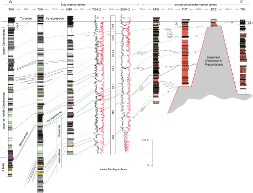
Click on thumbnail to enlarge the image.
Figure 17: Correlation of the medium-frequency sequences across the transect.
The correlation scheme, if correct, also shows that the Albian to Cenomanian M-F sequences are stacked into an overall backstepping trend on to the basement to the east, up to the Bou Tazoult area. The peak regression, at the marine end of the transect, is at the top of the Albian (see also
Fig. 6 ![]() ) but this uppermost Albian sequence is already onlapping onto the basement to the east (Tizi N'Test section,
Fig. 17
) but this uppermost Albian sequence is already onlapping onto the basement to the east (Tizi N'Test section,
Fig. 17 ![]() ). The outer limit of red siltstone in H-F sequences backsteps increasingly in upper Cenomanian deposits (sequences Ce3 to Ce 6,
Fig. 17
). The outer limit of red siltstone in H-F sequences backsteps increasingly in upper Cenomanian deposits (sequences Ce3 to Ce 6,
Fig. 17 ![]() ), up to the
early Turonian maximum flooding.
), up to the
early Turonian maximum flooding.
Regarding the last Cenomanian sequence (Ce7, Fig. 17 ![]() ), wherein occurs the CTB δ13C shift in the Taghazoute section
(Fig. 3
), wherein occurs the CTB δ13C shift in the Taghazoute section
(Fig. 3 ![]() ) ( et al.,
2010), its absence in the middle part of the transect suggests that the Cenomanian-Turonian boundary interval, marked by anoxia in the Atlantic (Oceanic Anoxic Event 2 or OAE2), was accompanied by a bending of the whole depositional profile on the Moroccan margin. This bending of the African plate to the east would explain that the exposure surface capping the Ce7 sequence in the Taghazoute section
(Fig. 2
) ( et al.,
2010), its absence in the middle part of the transect suggests that the Cenomanian-Turonian boundary interval, marked by anoxia in the Atlantic (Oceanic Anoxic Event 2 or OAE2), was accompanied by a bending of the whole depositional profile on the Moroccan margin. This bending of the African plate to the east would explain that the exposure surface capping the Ce7 sequence in the Taghazoute section
(Fig. 2 ![]() ) is correlated with a simple transgression surface without emersion in the PreAfrican Trough to the east (Tinghir section,
Fig. 16
) is correlated with a simple transgression surface without emersion in the PreAfrican Trough to the east (Tinghir section,
Fig. 16 ![]() ) according to the sedimentary and carbon isotope data of et al.
(2012) and et al.
(2013).
) according to the sedimentary and carbon isotope data of et al.
(2012) and et al.
(2013).
The type-sequences recognized along the transect (Figs.
4 ![]() ,
7
,
7 ![]() & 13
& 13 ![]() ) are organized downdip to updip into a scheme based on the correlation of transgressive surfaces
(Fig. 18.A
) are organized downdip to updip into a scheme based on the correlation of transgressive surfaces
(Fig. 18.A ![]() ). In this respect, high-frequency T-R sequences may be compared to the flooding surfaces bounding parasequences of the sequence stratigraphic model ( et al.,
1988; & ,
1988; et al.
(1991), also known as the "Exxon model". In the typical sequences of updip sections studied here, there is a progressive transition from tidal-flat deposits to continental red siltstone
(Fig. 18.A
). In this respect, high-frequency T-R sequences may be compared to the flooding surfaces bounding parasequences of the sequence stratigraphic model ( et al.,
1988; & ,
1988; et al.
(1991), also known as the "Exxon model". In the typical sequences of updip sections studied here, there is a progressive transition from tidal-flat deposits to continental red siltstone
(Fig. 18.A ![]() ), through evaporite deposits, meaning that the depositional environment was progressively drying up, evolving from lagoons to distal continental piemont. The basal surface of red siltstone, or the marine-continental transition, is called here a continental aggradation surface (CAS,
Fig. 18.A
), through evaporite deposits, meaning that the depositional environment was progressively drying up, evolving from lagoons to distal continental piemont. The basal surface of red siltstone, or the marine-continental transition, is called here a continental aggradation surface (CAS,
Fig. 18.A ![]() ). Red deposits are obviously integrated into a regressive trend vertically in the sequence, which translates into a prograding pattern seen along the depositional profile. It means that red deposits should be downlapping on to the CAS downdip, as the seawardshift of the shoreline proceeds
(Fig. 18.A
). Red deposits are obviously integrated into a regressive trend vertically in the sequence, which translates into a prograding pattern seen along the depositional profile. It means that red deposits should be downlapping on to the CAS downdip, as the seawardshift of the shoreline proceeds
(Fig. 18.A ![]() ). In this respect the H-F sequence fits the above parasequence concept, or that of T-R genetic sequences of
(1989), in which the seawardshift of the shoreline is accompanied by the aggradation of continental deposits updip.
). In this respect the H-F sequence fits the above parasequence concept, or that of T-R genetic sequences of
(1989), in which the seawardshift of the shoreline is accompanied by the aggradation of continental deposits updip.
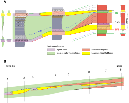
Click on thumbnail to enlarge the image.
Figure 18: The depositional model for high-frequency sequences. A, correspondences between the distal and proximal type-sequences (CAS, continental aggradation surface; FRW, forced regressive wedge). B, a more realistic illustration of the forced regressive wedge, in which the irregular stepped forced regressions may create all the H-F sequences (1 to 8) seen in outcrops along the transect. Explanations in the text.
However, there are observations that do not fit the parasequence concept, as defined by et al.
(1988), especially, the sharp surface that at the base bounds the shallowest marine deposits in the observed sequences (tidal-flat facies in updip position, beach calcarenites or shell-hash beds in distal position,
Fig. 18.A ![]() ). This surface suggests that there is, everywhere along the depositional profile, a break in the regressive facies trend above the fully marine marlstone representing the maximum flooding in the sequences. This facies break is basically a sea-level fall surface (SFS,
Fig. 18.A
). This surface suggests that there is, everywhere along the depositional profile, a break in the regressive facies trend above the fully marine marlstone representing the maximum flooding in the sequences. This facies break is basically a sea-level fall surface (SFS,
Fig. 18.A ![]() ) that shunts the vertical facies transition between the deep-water marlstone and the beach or tidal-flat deposits, a transition expected to occur in a regular regressive trend. The problem is how to explain that such a surface can be present in practically all the sequences observed, updip to downdip. Furthermore, the very atypical sequences in which red siltstone occurs sharply within marine green marlstone need to be explained
(Fig.
13
) that shunts the vertical facies transition between the deep-water marlstone and the beach or tidal-flat deposits, a transition expected to occur in a regular regressive trend. The problem is how to explain that such a surface can be present in practically all the sequences observed, updip to downdip. Furthermore, the very atypical sequences in which red siltstone occurs sharply within marine green marlstone need to be explained
(Fig.
13 ![]() , end-member c). This kind of atypical sequence is not confined to Cenomanian deposits ; it has also be found frequently in the Hauterivian Talmest Formation of the same margin (S. and O. , work in progress), in Barremian deposits ( et al.,
2013) and in the northern Cenomanian transect under study
(Fig. 1
, end-member c). This kind of atypical sequence is not confined to Cenomanian deposits ; it has also be found frequently in the Hauterivian Talmest Formation of the same margin (S. and O. , work in progress), in Barremian deposits ( et al.,
2013) and in the northern Cenomanian transect under study
(Fig. 1 ![]() , dotted blue line). Therefore, this sequence type should be given some attention, and be fully integrated into the depositional model.
, dotted blue line). Therefore, this sequence type should be given some attention, and be fully integrated into the depositional model.
The concept of Forced Regressive Wedge Systems Tract ( & ,
1992) helps to interpret both the systematic occurrence of sea-level fall surfaces (SFS) in observed H-F sequences, and also the end-member atypical sequences
(Fig.
13 ![]() ). This concept results from the criticism that has arisen in the 1980s against the absence of deposition during the falling stage of relative sea level in the Exxon model. &
(1992) coined the concept of "stranded parasequences" or sharp-based parasequences ( & ,
2000; & ,
2000), recording this falling stage. Stranded parasequence are bounded at base by a regressive surface of marine erosion (RSME) (,
1988; & ,
2000) explaining the sharp-based sandstone bodies deposited on offshore claystone. The basal surface of forced regression (BSFR) ( & ,
1992) occurs at base of a set of stranded parasequence of the falling stage, and is used to define the base of lowstand deposits. According to the synthesis of
et al. (2011), the sequence boundary defining the lowstand systems tract of a sequence is at the base of the first stranded parasequence or at the base of the first downward-shifted clinoform.
). This concept results from the criticism that has arisen in the 1980s against the absence of deposition during the falling stage of relative sea level in the Exxon model. &
(1992) coined the concept of "stranded parasequences" or sharp-based parasequences ( & ,
2000; & ,
2000), recording this falling stage. Stranded parasequence are bounded at base by a regressive surface of marine erosion (RSME) (,
1988; & ,
2000) explaining the sharp-based sandstone bodies deposited on offshore claystone. The basal surface of forced regression (BSFR) ( & ,
1992) occurs at base of a set of stranded parasequence of the falling stage, and is used to define the base of lowstand deposits. According to the synthesis of
et al. (2011), the sequence boundary defining the lowstand systems tract of a sequence is at the base of the first stranded parasequence or at the base of the first downward-shifted clinoform.
In the case studied here, the regressive half-cycle of the T-R high-frequency sequence is thought to proceed, updip to downdip along the whole profile, through a number of forced regressions, explaining the systematic occurrence of SFS or RSME in the observed H-F sequences. The forced regression process starts just after the peak transgression of tidal flats into the fluvial depositional environment
(Fig. 18.B ![]() ). The whole regressive half-cycle is thus considered a forced regressive wedge (FRW,
Fig. 18.A
). The whole regressive half-cycle is thus considered a forced regressive wedge (FRW,
Fig. 18.A ![]() ). The continental aggradation surface (CAS) is basically an heterochronous surface, as it is formed during the seawardshift of the shoreline, and the progressive advance of red claystone on marine deposits. Continental deposits are thus considered as downlapping on to this surface
(Fig. 18.A
). The continental aggradation surface (CAS) is basically an heterochronous surface, as it is formed during the seawardshift of the shoreline, and the progressive advance of red claystone on marine deposits. Continental deposits are thus considered as downlapping on to this surface
(Fig. 18.A ![]() ).
).
Depending on the way (regular or not) the stepped regression proceeds, a number of possibilities may occur (type-sequences 1 to 8,
Fig. 18.B ![]() ). Successive forced regressive beach prisms may be nested or more or less disconnected along the profile. In type-sequence 3, the vertical facies succession may fit the parasequence concept, with only one stratigraphic surface (the transgressive ravinement surface) being present above a seemingly regular regressive facies succession. When the shift of the shoreline is quick and strong, no beach prism is deposited, and regressive red siltstone will rest directly on trangressive offshore marlstone (atypical type-sequence 5,
Fig. 18.B
). Successive forced regressive beach prisms may be nested or more or less disconnected along the profile. In type-sequence 3, the vertical facies succession may fit the parasequence concept, with only one stratigraphic surface (the transgressive ravinement surface) being present above a seemingly regular regressive facies succession. When the shift of the shoreline is quick and strong, no beach prism is deposited, and regressive red siltstone will rest directly on trangressive offshore marlstone (atypical type-sequence 5,
Fig. 18.B ![]() ). The model proposed here is able to explain all the atypical sequences found. It is thought to occur only on very gently inclined, almost flat, depositional profiles, on which the slightest seawardshift of the shoreline may have strong consequences for the stratal pattern. On steeper ramps, slight sea-level falls will not influence the stratal pattern in such a strong way.
). The model proposed here is able to explain all the atypical sequences found. It is thought to occur only on very gently inclined, almost flat, depositional profiles, on which the slightest seawardshift of the shoreline may have strong consequences for the stratal pattern. On steeper ramps, slight sea-level falls will not influence the stratal pattern in such a strong way.
The regional correlation scheme (Fig. 17 ![]() ) suggests that M-F sequences Abs to Ce6 are simple T-R sequences bounded by major flooding surfaces. They can be traced along the depositional profile till their onlap on the basement, when approaching the Bou Tazoult high. Sequence Ce7 is only recognized close to the margin, where it is bounded by two exposure surfaces ( et al.,
2010). This is explained by the deformation of the margin around the C-T boundary. The buiding blocks of the M-F sequences are the H-F sequences described and interpreted above. In the regressive half-cycle of the M-F sequence, H-F sequences are increasingly affected by the progradation of fluvial deposits. These deposits are probably the distal, clay-dominated part of a gently sloping fluvial piedmont anchored on the Anti-Atlas Massif. There is no clear evidence that part of the present-day High-Atlas may have been the source for detrital material in Albian-Cenomanian times, despite the fact that some inclined beach strata may be oriented to the south in the Afansou section
(Fig. 12.A
) suggests that M-F sequences Abs to Ce6 are simple T-R sequences bounded by major flooding surfaces. They can be traced along the depositional profile till their onlap on the basement, when approaching the Bou Tazoult high. Sequence Ce7 is only recognized close to the margin, where it is bounded by two exposure surfaces ( et al.,
2010). This is explained by the deformation of the margin around the C-T boundary. The buiding blocks of the M-F sequences are the H-F sequences described and interpreted above. In the regressive half-cycle of the M-F sequence, H-F sequences are increasingly affected by the progradation of fluvial deposits. These deposits are probably the distal, clay-dominated part of a gently sloping fluvial piedmont anchored on the Anti-Atlas Massif. There is no clear evidence that part of the present-day High-Atlas may have been the source for detrital material in Albian-Cenomanian times, despite the fact that some inclined beach strata may be oriented to the south in the Afansou section
(Fig. 12.A ![]() ). This may be explained by a bending of the shoreline into the Souss Basin, forming an embayment.
). This may be explained by a bending of the shoreline into the Souss Basin, forming an embayment.
There are too few sections available for more detailed correlations along the updip part of the transect where continental deposits are present. It is therefore not possible to figure out whether the stratal pattern of H-F sequences obeys a rule within the regressive half-cycle of M-F sequences (for instance the trajectory of the continental-marine transition), or if randomness prevails.
The discussion focusses on the following points: (a) how to classify the H-F sequences, (b) the pattern of the M-F sequences, and (c) the timing of fluvial aggradation.
The observed sequences in the Cenomanian deposits of the Moroccan margin raise a number of questions regarding the applicability of sequence stratigraphic models.
According to et al.
(2011), there should be no time tag attached to the concept of depositional sequence. A parasequence is, by definition, a T-R sequence in which the only stratigraphic surface is a transgression surface separating the prograding from the retrograding facies tracts. Conversely, a sequence bounded by a sea level fall surface should be called a depositional sequence, whatever its thickness or duration. It should be noted, however, that in platform carbonate environments, the notion of parasequence may be somewhat different ( et al.,
1990; et al.,
1999; & ,
1999, 2007; & ,
2010), especially because, among others, many of high-frequency sequences are capped by emergence surfaces. But this kind of depositional environments lacks studies of detailed serial sections to understand the relationship with deeper water high-frequency cycles. In the original version of the sequence stratigraphy model ( et al.,
1988; & ,
1988; et al.,
1988; et al., 1991), parasequences were considered as the building blocks of sequences. These are bounded by sea level fall surfaces (sequences boundaries), on which are deposited either shelf margin wedges or lowstand wedges, depending on the balance between the subsidence and the eustatic components of sea level change. The concept of forced regression and stranded parasequences during the falling stage of sea level ( & ,
1992; & ,
2000) was next integrated in the model ( et al.,
2011). A depositional sequence could thus comprises both flooding surface bounded parasequences and sharp-based parasequences, depending on the position on the rising or falling limb of the eustatic component of the relative sea level change. A first problem with the Moroccan case, is that a given H-F sequence may look like a normal parasequence or a sharp-based parasequence depending on the position along the depositional profile
(Fig. 18.B ![]() ). A second problem is that the whole pile of H-F sequences presents the same characteristics, meaning that, if strictly applying the definitions, the Cenomanian would comprise more than seventy sequences in the mixed Afansou section
(Fig. 12
). A second problem is that the whole pile of H-F sequences presents the same characteristics, meaning that, if strictly applying the definitions, the Cenomanian would comprise more than seventy sequences in the mixed Afansou section
(Fig. 12 ![]() ), which will therefore pose a problem with the three to four sequences recognized in the eustatic chart ( et al.,
1987).
), which will therefore pose a problem with the three to four sequences recognized in the eustatic chart ( et al.,
1987).
The pattern of M-F sequences along the studied transect does not permit the recognition of any lowstand wedge or shelf margin wedge, which are the two kinds of response to a eustatic sea level fall in the model of sequence stratigraphy. Instead, we recognize in Cenomanian deposits six well-developped T-R supersequences. These M-F sequences, as they are called here, are bounded by major flooding surfaces that can be traced updip well into the continental deposits. There is no evidence of stratigraphic surfaces that could bound at base so-called shelf margin wedges within the regressive half-cycle of these sequences.
Regarding the timing of fluvial aggradation, different concepts are found in the literature. In the genetic model of
(1989), as well as in the sequence stratigraphy model of , and co-workers, continental deposits are deposited on marine deposits during the seawardshift of the bayline. The seawardshift of the fluvial equilibrium profile attached to the bayline is supposed to create accomodation space updip, which is filled with fluvial deposits. In this respect, fluvial deposits are basically regressive. Other models of genetic stratigraphy ( et al.,
1992) are based on the concepts of
(1988), in which the fluvial aggradation is theoretically only possible, or mainly occurs ( & ,
1998) during the rise in base level. The difference in the concepts are based on field observations but it should be noted that these observations come from two basic geodynamic contexts, passive margins for the sequence stratigraphy model, foreland basins for the model. The locus of maximum subsidence is different in both contextes, in the foothills of the chain in foreland basins, in the offshore on passive margins. This may explain the differences in the models regarding the timing of the fluvial aggradation in sequences. The interpretative model here proposed is in good
accordance with the concepts of sequence stratigraphy of the , , and co-workers school of thought with respect to the timing of fluvial aggradation. Fluvial aggradation is interpreted as basically regressive in high-frequency sequences on the Moroccan margin
(Fig. 18.B ![]() ).
).
The upper Albian to Turonian sedimentary wedge of the Moroccan Atlantic margin has been studied through detailed serial sections along a W-E transect spanning more than 150 km, in order to study the stratal pattern of sequences. Regarding the depositional facies, the transect covers a range of environments going from the upper offshore to the continental piemont attached to the emerged Anti-Atlas massif. Seven medium-frequency T-R sequences are recognized in Cenomanian deposits. The high-frequency T-R sequences, owing to their very high number (more than seventy) in Cenomanian deposits, could be considered as T-R parasequences but they bear, instead, all the attributes of full depositional sequences, according to the definitions of sequence stratigraphy. Their regressive half-cycle is always a forced regressive wedge made of nested beach prims, dragging behind them the red deposits of the fluvial piemont during the seawardshift of the shoreline. The pile of these H-F sequences, on the other hand, cannot be partitionned into highstand and lowstand systems tracts of the sequence stratigraphy model. They are instead organized as simple T-R supersequences, bounded by major flooding flooding surfaces that can be traced as thin tidal flat deposits updip into the red siltstones of the fluvial piemont, as for the H-F sequences. Finally, we show that the Moroccan case is a nice example on how the stratal pattern of depositional sequences can be distorted on nearly flat ramps, and how it may push the applicability of existing sequence stratigraphic models into dead ends.
This work has been financially supported by the French-Moroccan PHC Volubilis MA/09/208, in which B. conducted his PhD. We also thank the Ibn Zohr University, Agadir, for its supplementary logistical support for field work. We thank the very constructive comments of reviewers Maurice E. (England), and Markus (Germany), both in writing and on the ground. Phil did a careful checking of the second version of the manuscript.
R. (1963).- Étude gÚologique du versant mÚridional du Haut Atlas occidental et de la plaine du Souss.- ThÞse Doctorat d'État, UniversitÚ de Paris; Notes et MÚmoires du Service gÚologique du Maroc, Rabat, nº 157, 321 p. (3 Pls.).
J.-P. (1973).- Contribution Ó l'Útude stratigraphique du MÚsozo´que de l'Atlas saharien occidental (AlgÚrie).- ThÞse Doctorat d'État, UniversitÚ Pierre et Marie Curie, Paris, 497 p.
M., M., F.-Z. & M. (2008).- New stratigraphic data from the cretaceous basin of Guir (BÚchar, South-western of Algeria).- Documents des Laboratoires de GÚologie de Lyon, Villeurbanne, vol. 164, p. 19-22.
M., C., M. & F.-Z. (2012).- La plateforme prÚafricaine (CÚnomanien supÚrieur - Turonien infÚrieur) dans la rÚgion de BÚchar (AlgÚrie) : stratigraphie, palÚoenvironnements et signification palÚobiogÚographique.- Revue de PalÚobiologie, GenÞve, vol. 31, p. 205-218.
M., M., C., E., F.-Z., K., A., D., A. & M. (2014).- Le "Continental Intercalaire" dans la rÚgion du Guir (AlgÚrie) : nouvelles donnÚes palÚontologiques, ichnologiques et sÚdimentologiques.- Revue de PalÚobiologie, GenÞve, vol. 33, nº 1, p. 281-297.
M. & C. (2015).- Lithostratigraphic evolution, facies analysis and depositional environment of the Cenomanian-lower Turonian in the Guir area, Southwestern Algeria.- Cretaceous Research, vol. 53, p. 68-88.
G. (1970).- Le MÚsozo´que saharien. 2Þme partie : Essai de synthÞse des donnÚes des sondages algÚro-tunisiens.- Publications C.R.Z.A.-C.N.R.S., Paris, vol. l, 340 p., vol. 2, 811 p.
M. (1985).- Cretaceous foraminifera. In: H.M., ed., Plankton stratigraphy.- Cambridge University Press, p. 17-86.
O., W.E., C.G.St.C., A.D., H.W., A. & M.E. (2011).- Sequence stratigraphy: Methodology and nomenclature.- Newsletters on Stratigraphy, Stuttgart, vol. 44, nº 3, p. 173û245.
L., L., S., L., J., I. & H. (2001).- L'Úvolution palÚoenvironnementale des faunes de poissons du CrÚtacÚ supÚrieur du bassin du Tafilalt et des rÚgions avoisinantes (Sud-Est du Maroc) : implications palÚobiogÚographiques.- Comptes Rendus de l'AcadÚmie des Sciences, Paris, (Sciences de la Terre et des PlanÞtes), vol. 333, p. 677-683.
L., H., L., C., A., J., M., R., E., G., S. & J. (2010).- Vertebrate assemblages from the early Late Cretaceous of southeastern Morocco: An overview.- Journal of African Earth Sciences, vol. 57, nº 5, p. 391-412.
R., B., A., E. & A. (1999). - Le CrÚtacÚ antÚturonien du Moyen Atlas mÚridional et de la Haute Moulouya, Maroc : stratigraphie sÚquentielle et palÚoenvironnements.- Bulletin de la SociÚtÚ gÚologique de France, Paris, vol. 170, nº 4, p. 451-464.
T.A. (1988).- Controls on coal distribution in transgressive-regressive cycles, Upper Cretaceous, Western Interior, USA. In: C.K., B.S., C.G.St.C., H.W., C.A. & J.C., eds., Sea-level changes - An integrated approach.- Society of Economic Paleontologists and Mineralogists Special Publications, Tulsa, vol. 42, p. 371-380.
T.A. & M.A. (1998).- Sediment volume partitioning: rationale for stratigraphic model evaluation and high-resolution stratigraphic correlation. In: F.M., K.O. & N.J., eds., Predictive high resolution sequence stratigraphy.- Norwegian Petroleum Society Special Publications, Oslo, vol. 8, p. 171-195.
J. (1974).- La sÚdimentation delta´que ancienne. Exemples nord-sahariens.- Bulletin du Centre de Recherches de Pau - SNPA, vol. 8, nº 1, p. 24-62.
N. (1990).- Le CÚnomanoûTuronien du bassin d'Agadir (Haut Atlas occidental, Maroc) : biostratigraphie, sÚdimentologie et essai de caractÚrisation des sÚquences de dÚp¶t.- ThÞse de Doctorat de l'UniversitÚ Cadi Ayyad, Marrakech, 128 p.
E.M., A., B. & M. (2005).- La limite CÚnomanien-Turonien dans le Haut Atlas central, Maroc.- Geobios, Villeurbanne, vol. 38, nº 1, p. 57-68.
de D., C., N., J.-C., C. & J.-C. (2011).- The southernmost margin of the Tethys realm during the Mesozoic and Cenozoic: Initial geometry and timing of the inversion processes.- Tectonics, Washington, vol. 30, nº 3, TC3002, 22 p.
W.E. (1989).- Genetic stratigraphic sequences in basin analysis I: Architecture and genesis of flooding-surface bounded depositional units.- AAPG Bulletin, Tulsa, vol. 73, nº 2, p. 125-142.
R.K., P.A. & L.A. (1990).- Depositional cycles, composite sea-level changes, cycle stacking patterns, and the hierarchy of stratigraphic forcing: examples from Alpine Triassic platform carbonates.- Geological Society of America Bulletin, Boulder, vol. 102, p. 535-562.
D., S., F., F., M., F. & W. (2008).- The Upper Cenomanian-Turonian (Upper Cretaceous) of the Saharan Atlas (Algeria).- Bulletin de la SociÚtÚ gÚologique de France, Paris, vol. 179, nº 6, p. 593-603.
D., S., M., M., M., F., F., F., H. & H. (2013).- The Cenomanian-Turonian boundary on the Saharan Platform (Tunisia and Algeria).- Cretaceous Research, vol. 42, p. 66-84.
H., A., B. & P.-O. (2008).- Les dÚp¶ts continentaux du Jurassique moyen au CrÚtacÚ infÚrieur dans le Haut Atlas oriental (Maroc) : palÚoenvironnements successifs et signification palÚogÚographique.- Carnets Geol., Madrid, CG2008_A06, 29 p.
H., A. & P.-O. (2010).- Stratigraphie et sÚdimentologie des "Couches rouges" continentales du Jurassique-CrÚtacÚ du Haut Atlas central (Maroc) : implications palÚogÚographiques et gÚodynamiques.- Geobios, Villeurbanne, vol. 43, nº 4, p. 433-451.
B.U., J. & P.R. (1987).- Chronology of fluctuating sea levels since the Triassic.- Science, Washington, vol. 235, p. 1156-1167.
L. & L.H. (2000).- Shingled, sharp-based shoreface sandstones: depositional response to stepwise forced regression in a shallow basin, Upper Triassic Gassum Formation, Denmark.- Geological Society, London, Special Publications, vol. 172, p. 69-89.
P.W., F., R. & T.A. (1992).- Correlations haute-rÚsolution et stratigraphie gÚnÚtique : une dÚmarche intÚgrÚe.- Bulletin des Centres de Recherche Exploration-Production elf Aquitaine, Pau, vol. 16, p. 357-382.
D. & M.E. (1992).- Stranded parasequences and the forced regressive wedge systems tract: deposition during base-level fall.- Sedimentary Geology, vol. 81, nº 1, p. 1-9.
M., D., S., M., M., N., F. & D. (2010).- The CenomanianûTuronian boundary event on the Moroccan Atlantic margin (Agadir basin): Stable isotope and sequence stratigraphy.- Palæogeography, Palæoclimatology, Palæoecology, vol. 296, nº 1-2, p. 151-164.
V., C., B., M.-J., E.M. & L. (2013).- Geochemical and palaeoecological record of the CenomanianûTuronian Anoxic Event in the carbonate platform of the Preafrican Trough, Morocco.- Palæogeography, Palæoclimatology, Palæoecology, vol. 369, p. 79-98.
C., B., E. M., M.-J., V. & C. (2012).- The upper Cenomanian-lower Turonian of the Preafrican Trough, Morocco.- Sedimentary Geology, vol. 245-246, p. 1-16.
P.D. & P.M. (2013).- Additions to the sauropod dinosaur fauna of the Cenomanian (early Late Cretaceous) Kem Kem beds of Morocco: Palaeobiogeographical implications of the mid-Cretaceous African sauropod fossil record.- Cretaceous Research, vol. 45, p. 49-59.
D.M., N., P.M., L., S., R., D. & R. (2011).- A new Plattenkalk Konservat Lagerstõtte in the Upper Cretaceous of Gara Sbaa, south-eastern Morocco.- Cretaceous Research, vol. 32, nº 4, p. 433-446.
M., F., S., N. & D. (2013).- First dinosaur tracks from the Lower Cretaceous of the western High Atlas (Morocco).- Geogaceta, Madrid, vol. 53, nº 1, p. 33-36.
A.G. (1988).- Sharp-based shoreface sequences and "offshore bars" in the Cardium Formation of Alberta; their relationship to relative changes in sea level. In: C.K., B.S., C.G.St.C., H.W., C.A. & J.C., eds., Sea-level changes - An integrated approach.- Society of Economic Paleontologists and Mineralogists Special Publications, Tulsa, vol. 42, p. 357û370.
A.G. & D. (2000).- The falling stage systems tract: recognition and importance in sequence stratigraphic analysis.- Geological Society, London, Special Publications, vol. 172, p. 1-17.
H.W., M.T. & P.R. (1988).- Eustatic controls on clastic deposition I - Conceptual framework. In: C.K., B.S., C.G.St.C., H.W., C.A. & J.C., eds., Sea-level changes - An integrated approach.- Society of Economic Paleontologists and Mineralogists Special Publications, Tulsa, vol. 42, p. 109-124.
H.W. & P.R. (1988).- Eustatic controls on clastic deposition II - Sequence and systems tract models. In: C.K., B.S., C.G.St.C., H.W., C.A. & J.C., eds., Sea-level changes - An integrated approach.- Society of Economic Paleontologists and Mineralogists Special Publications, Tulsa, vol. 42, p. 125-154.
F., M. et le Groupe de Travail EuropÚen des ForaminifÞres Planctoniques (1979).- Atlas des ForaminifÞres planctoniques du CrÚtacÚ Moyen (Mer BorÚale et TÚthys).- Cahiers de MicropalÚontologie, Paris, vol. 1, 185 p.; vol. 2, 181 p.
F. & M. (1995).- ForaminifÞres planctoniques du CrÚtacÚ : commentaire de la zonation Europe-MÚditerranÚe.- Bulletin de la SociÚtÚ gÚologique de France, Paris, vol. 166, nº 6, p. 681-692.
G.H. & M.E. (1999).- Modeling carbonate microfacies in the context of high-frequency dynamic relative sea-level and environmental changes.- Journal of Sedimentary Research, Tulsa, vol. 69, nº 4, p. 947-961.
G.H. & M.E. (2007).- A proposed integrated multi-signature model for peritidal cycles in carbonates.- Journal of Sedimentary Research, Tulsa, vol. 77, nº 10, p. 797û808.
A., B., H. & J.-B. (1999).- Depositional sequences in shallow carbonate-dominated sedimentary systems: concepts for a high-resolution analysis.- Sedimentary Geology, vol. 128, nº 3-4, p. 201û221.
M.E. & J. (2010).- High-frequency cycles and their sequence stratigraphic context: orbital forcing and tectonic controls on Devonian cyclicity, Belgium.- Geologica Belgica, Brussels, vol. 13, nº 3, p. 213-240.
P.R., F., S.A., P.N. & C. (1991).- The stratigraphic signatures of tectonics, eustacy and sedimentology, an overview. In: G., W. & A., eds., Cycles and events in stratigraphy.- Springer Verlag, Berlin, p. 617-659.
P.R., R.M. Jr & S. III (1977).- Seismic stratigraphy and global changes of sea level, part 4: Global cycles of relative changes of sea level. In: C.E., ed., Seismic stratigraphy - Applications to hydrocarbon exploration.- American Association of Petroleum Geologists Memoirs, Tulsa, vol. 26, p. 83-97.
J.C., H.W., R.M., P.R., J.F., T.S. & J. (1988).- An overview of sequence stratigraphy and key definitions. In: C.K., B.S., C.G.St.C., H.W., C.A. & J.C., eds., Sea-level changes - An integrated approach.- Society of Economic Paleontologists and Mineralogists Special Publications, Tulsa, vol. 42, p. 39û45.
P. & J. (1982).- Sedimentation in the Atlas Gulf II: Mid-Cretaceous events. In: U. von, K., M. & E., eds., Geology of the North West African continental margin.- Springer-Verlag, Berlin, p. 439û459.